Archive for August, 2021

Gully Plan of 2021 is unbelievably No.19

Wednesday, August 25th, 2021

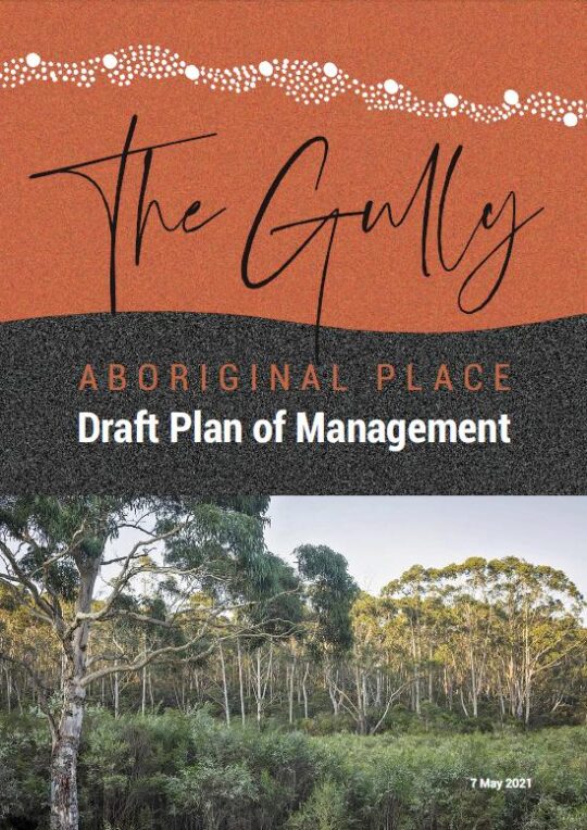
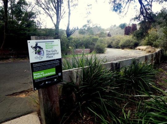
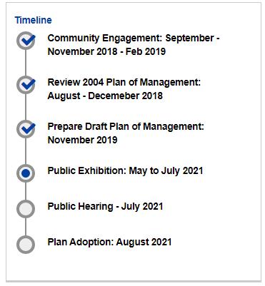
This was the May 2022 draft, however on this website we include Blue Mountains {city} Council’s complete final version dated 4th October 2022, which numbers 145 pages.  Click our internal website link below to download a PDF copy of this entire Gully Plan of Management 2021 (Final), ^https://www.habitatadvocate.com.au/wp-content/uploads/2021/11/The-Gully-POM-4-Oct-2021.pdf


Local residents in and around The Gully water catchment area situated on the western side of the rural township of Katoomba may be astounded by the following truths we at The Habitat Advocate have gleamed of late about Blue Mountains Council’s legacy of plans for The Gully.

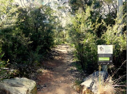
An analysis by our editor into the archival records maintained by The Habitat Advocate reveals that this current report/plan by Blue Mountains Council entitled The Gully Aboriginal Place Draft Plan of Management dated 7th May 2021 is actually Plan Number 19.   There could well be more out there. 

Don’t believe it?   Well we have a copy of almost every one of the nineteen reports, and these are just the ones we know about.  This revelation comes after being a member of one of the longest lasting environmental groups in the Blue Mountains region, ‘The Friends of Katoomba Falls Creek Valley Inc.’ which lasted for 28 years initially forming informally in 1988 to protest and lobby against the Catalina Raceway from 1988 incensed by Bob Jane’s helicopter buzzing low over residents’ homes around what was then Catalina Park.   Over the span of half a lifetime, The Friends fought many a campaign against a host of environmental threats to the valley/gully and amassed a considerable record of material during that period.

The following is our list of the planning reports into The Gully:


List of Plans for The Gully, so far…


  1. Katoomba Falls Creek Valley Environmental Study A & B (date TBA)
  2. FWP – ‘Bushland Management and Report’, (date TBA)
  3. Frank Walford Park Master Plan for Development 1955 (car racetrack), by Katoomba Municipal Council
  4. Draft Assessment of Frank Walford Park, Katoomba – Land Suitability, Environmental Constraints, circa 1980
  5. Frank Walford Park Management Plan 1981, 54 pages
  6. Katoomba Falls Creek Valley by Neil Stuart (provided to Wentworth Falls TAFE Library on special reserve), 1988 and revised in 1991
  7. Katoomba Falls Reserve Draft Plan of Management, Volume 1, by Mandis Roberts Consultants for Blue Mountains City Council and  the NSW Department of Lands, April 1990 (possibly a Volume 2 as well)              
  8. Katoomba Falls Creek Valley Environmental Study – Part 1 (Draft Report and Management Plan of 87 pages) and Part 2 (Technical Reports, Data and Analysis of 55 pages) by Fred Bell of F.& J. Bell and Associates Pty Ltd and Dr Val Attenbrow, June 1993
  9. The Gully Archaeological Grant Project, 16th August 1995
  10. ‘Katoomba Falls Creek Valley Draft Plan of Management – Main Report’, by Des Brady of Connell Wagner Pty Ltd, of approximately 150 pages, April 1996       
  11. Frank Walford Park Plan of Management, December 1998
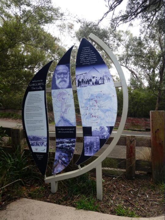
  12. Upper Kedumba Valley, Katoomba – Report on the cultural significance of Upper Kedumba Valley for declaration as an Aboriginal Place prepared by Dianne Johnson with Dawn Colless for NPWS, 162 pages, 3rd July 2000
  13. Draft Katoomba-Leura Vegetation Management Plan by Blue Mountains City Council, December 2000, 46 pages,
  14. Upper Kedumba River Valley Plan of Management (The Gully Aboriginal Place – Council Revised Edition, (Spiral Bound, 105 pages) by Environmental Partnership, February 2004
  15. Final Report for Sydney Catchment Authority – Catchment & Improvement Grant No. 44 Upper Kedumba River Vallkey, prepared by members of Kedumba Creek Bushcare 7 Blue Mountains City Council March 2005, 27 pages.
  16. A Heritage Study of the Gully Aboriginal Place, Katoomba, New South Wales by Allan Lance of Heritage Consulting Australia Pty Ltd August 2005 (2 versions – a detailed confidential version for the local Aboriginal peoples and a second summary version for Blue Mountains City Council, 113 pages)
  17. Construction Environmental Management Plan – Blue Mountains Sewer Trunk Mains Amplification: Upper Kedumba River Valley, South Katoomba Sewerage Catchment by Total Earth Care Pty Ltd for Sydney Water and Blue Mountains City Council, 17th October 2007, approximately 50 pages.
  18. Reconnecting to Country – Progress Report #2 by Rouse Water, Council, Gully Traditional Owners, Sustainable Futures Australia, Widjabul Custodians, September 2009. (possibly a Progress Report #1 as well)
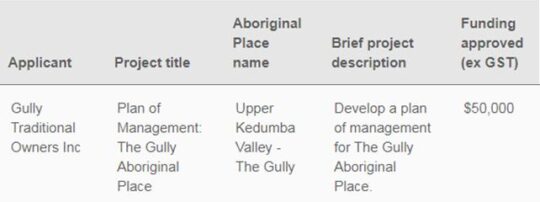
  19. The Gully Aboriginal Place Draft Plan of Management 7th May 2021, by Soren Mortensen and Brad Moore, Blue Mountains City Council, 142 pages.


As Council currently prepares its final version of its 2021 plan version for The Gully, the obvious critique we posit to Council is that it is about time Council actually focuses on implementing its plans rather repeatedly spending money having more plans written.   

We point out that the only plan on The Gully that Council has funded out of its budget (ratepayers’ money) and not from external grants was the construction of the racetrack in 1959.   And then the funding was a loan to the then Blue Mountains Sporting Drivers’ Club Ltd, a collection of wealthy local business men who persuaded Council to bulldoze the homes of the poor residents so they could race cars on a new racing circuit. 

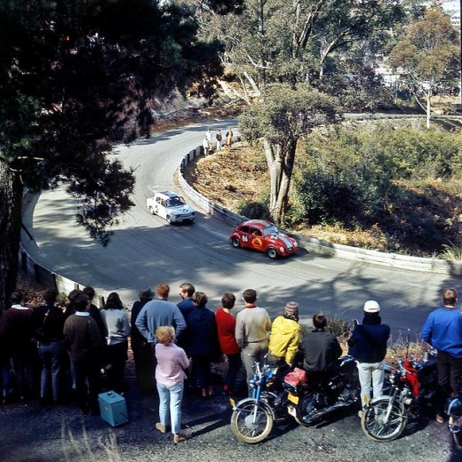
Catalina Park Raceway operated officially from 1961 to 1971 when the organisation running it, the Blue Mountains Sporting Drivers Club went into liquidation.


Council’s loan was in excess of £20,000 (say a conservative $40,000 equivalent at the time, since at the Australian government’s switch to decimal currency back in 1966 set the conversion rate of $2 to being equivalent to £1 (Australian).

[SOURCE:  Minutes of Special Meeting of the Council (duly convened) , Tuesday 13th day of January 1959, page 8, Item 45, signed as validated by the Mayor and Town Clerk and verbatim thus:

“Car Racing Track – Catalina Park, Katoomba. Page A12 Town Clerk’s Report.

Resolved on the motion of Alderman K. Smith and W. Smith that consideration be given when dealing with the Loan Estimates for 1959/60 to the inclusion of an amount of about £20,000 for the construction of a blacktopped surface to the racing track and the provision of adequate safety fencing.”

In today’s value that $40 000 would be valued at about $700,000 in today’s money in 2022.  That budget excludes the costs of Council’s contracted bulldozer work to  demolishing The Gully homes, then grade the new racetrack circuit, or the deforestation, or the construction of the changing sheds beside the lake, or the red brick toilet block inside the track circuit, or the addition of the dirt Rallycross circuit or the  other racing infrastructure. 

Loan calculation (estimate only):

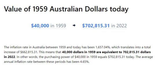
SOURCE: InflationTool.com website, ^https://www.inflationtool.com/australian-dollar/1959-to-present-value?amount=40000&year2=2022&frequency=yearly


That ratepayer loan by Council to the Blue Mountains Sporting Drivers’ Club Ltd was never repaid.   The opportunity cost of ratepayers’ wealth for more vital needs of the Blue Mountains would have been considerable.  It was an indulgence by certain councillors and their wealthy business mates and off-Mountains petrol heads to provide an exclusive hobby.  It was all bugger The Gully residents and the surrounding local residents with the decades of thunderous racetrack noise in the process.  Whilst the official racing ended in 1971, unofficial racing continued to 2002 when The Gully was gazetted an Aboriginal Place.  But the illegal motor racing  persisted for another three years until up to December 2005 – The Habitat Advocate as a local has records to support this.

Irresponsibly, council management and councillors at the time were mindful of Council’s massively over-indebtedness to the tune of £155,460 (excluding Electricity debts).   Records show that Council at the time had been threatened by legal action to withdraw its claim for loan recovery.  So likely due to Council’s then dire indebtedness at the time, Council cowered, backed off and wrote off racing track loan to its business mates.


Secret 2021 plans to sell off Gully bushland

Saturday, August 21st, 2021

The Gully in Katoomba – yet another vacuous draft Plan of Management by Council, 7 May 2021


A Brief Background


Back in 2004 a Plan of Management was published for The Gully in Katoomba by its government custodial owner Blue Mountains Council (Council).  This followed three years of Council delegating an off-Mountains consulting firm ‘Environmental Partnership‘ (Ultimo-based) to research and draft an expensive and length report of some 105 pages. 

This 2004 Plan followed a host of previous studies, reviews and reports including ‘The Bell Report’ of 1993 – its correct title being ‘Katoomba Falls Creek Valley Environmental Study‘ of some 87 pages undertaken by environmental consultants F. & J. Bell and Associates Pty Ltd.  This plan in 1993 had been commissioned by local Katoomba environmental activist group ‘The Friends of Katoomba Falls Creek Valley Inc.‘ (1989-2016) thanks to a $10,000 government grant which was the cost of this very details and independent study into Katoomba Falls Creek Valley, which was Council’s official name of The Gully at the time.   For more information on this study please refer to the Further Reading reference section at the end of this article.


The Gully’s evolving names


Note that the term ‘The Gully‘ was first officially applied to this creek valley in Katoomba by Council in the 2004 Plan of Management.  This is the 2004 Plan -was ridiculously long title of 16 words verbatim as:  

‘UPPER KEDUMBA RIVER VALLEY Plans of Management Covering the Community Lands within “The Gully” Aboriginal Place’. 

Put that up your jumper!   Here’s the original for reading, download and printing in the public domain:

Loader Loading...
EAD Logo Taking too long?

Reload Reload document
| Open Open in new tab

Download [2.12 MB]

It followed That draft document was entitled, which is an affectionate term used by former residents and their descendants from the 1950s and generation prior.  Other terms for The Gully have been:

  1. Blacks Camp‘ (a colonial disparaging term [1870s up to the 1950s] as cited in the book ‘Artificial Horizon – Imagining the Blue Mountains’, p.198, by Martin Thomas, 2004) (being the northern section)
  2. Katoomba Falls Creek Valley‘ (being the entire 70+ hectare creek valley of riparian bushland area still not yet sold off by Council for housing)
  3. Frank Walford Park‘ (being also the northern section)
  4. Walford Park’ (being also the northern section without Cr Walford’s first name ‘Frank’)
  5. McRae’s (horse) Paddock‘ (being the central section)
  6. Selby Street Reserve‘ (being the central section’s eastern side watercourse creek gully from a spring at now Hinkler Park)
  7. Katoomba Falls Reserve Cascades section‘ (being the same central section’s eastern side watercourse creek gully from a spring at now Hinkler Park)
  8. Catalina Park‘ (being the northern section named by Council in the late 1950s on behalf of the Blue Mountains Sporting Car Club Ltd)
  9. Upper Kedumba River Valley‘ (being the entire creek valley as renamed by Council in 2002)
  10. ‘Katoomba Falls Reserve’  (being the southern section dominated by two grass ovals named by Council)
  11. The Gully Aboriginal Place‘ (being a lesser portion of the entire 70+ hectare creek valley of riparian bushland, since many bushblocks of what as Community Land has been sold off for housing, or else rezoned or proposed for rezoning so that Council’s coffers can be boosted by land sales for more housing)
  12. Garguree‘ is apparently a regional Gundungurra Aboriginal word meaning ‘gully’ which was purportedly provided by a local historian into Blue Mountains Aboriginal heritage Jim Smith PhD acting as a consultant to The Gully Traditional Owners (group) circa 2007. 


Of note, two significant side watercourse gullies flowing into The Gully from the west are excluded from The Gully’s geographic scope by Council’s mapping. 

One side watercourse flows into The Gully through a very large bushland/riparian zone side gully having a land title address of 21 Stuarts Road, Katoomba.  The second to the south flows through what was clear-felled bushland/riparian zone and then bulldozed, graded and fertilized into the now defunct Katoomba Golf Course which Council had backed financially.  This year the site of the old Katoomba Golf Course is being prepared by Council, external consultants again enticing two universities to develop it as believe it or not a ‘Planetary Health Leadership Centre‘ – how hypocritical on a site of ecological destruction!

Recalling the 2004 Plan of Management and its drafting, despite many efforts by locals expressing a keen desire to constructively engage with Council to provide input into this Plan, Council arrogantly shunned these requests, so very little local community consultation went into this 2004 Plan.   

On page 101 under the sub-heading ‘Review of the plan of management‘ it reads as follows:

“It was the intention of the authors (Environmental Partnership) that the progress of implementation should be assessed by Council on an annual basis in terms of the performance measures described in Table 7 and updated or reviewed as appropriate.  It was also outlined in the plan of management that a more comprehensive review should be made after five years to assess the effectiveness of the plan and need for review.”


This is the Table 7:


Well, neither the annual assessment of progress nor the five year review took place.  None of the core objectives has been achieved by Council since 2004 (nor prior from the Bell Report of 1993) and it is now 2021. 

From our experience over the past twenty years as local activists to save and protect the ecology of The Gully, Council’s ongoing neglect and abuse of The Gully has persisted and particularly Council management’s disdain for local Bushcare volunteers to altruistically request Council to commit to caring for and rehabilitating The Gully’s natural ecology after decades of harm.   

It has taken until 2017 for Council to finally get around to reviewing its 2004 Plan of Management after some thirteen years, because Council was legally required to undertake a formal review of the 2004 Plan of Management – still pending in 2021…

“in accordance with the requirements of the Local Government Act 1993 (NSW) and the Crown Land Management Act 2016, and the Office of Environment and Heritage (OEH) Declared Aboriginal Place Guidelines for Development Management Plans.”     

[SOURCE: ‘Public Hearing for the Proposed Recategorisation of Community Land  in The Gully Aboriginal Place, July 2021, by Parkland Planners, Background Information, page 1, >https://www.habitatadvocate.com.au/wp-content/uploads/2021/08/Public-Hearing-for-Proposed-Recategorisation-of-Community-Land-in-The-Gully-Aboriginal-Place-July-2021.pdf]

The 2021 Plan has been prepared by Council’s contracted Environmental Planning Officer Soren Mortensen and Council’s Aboriginal Community Development Officer Brad Moore is vastly different to the 2004 plan.  However a quick comparison of the 2004 Plan and the current 2012 draft Plan reveals that most of 2004 Plan’s 105 pages have been ignored in the 2012 draft plan.   The current 2012 draft plan reads more like a cultural document borrowed from elsewhere and applied to The Gully instead of being as a place-based plan of management for a natural place as is the 2004 plan.


Our concerns about Council’s proposed “Re-categorisation” of ‘Community Land’ in The Gully


After 20 years experience in trying to consult with Blue Mountains Council about The Gully (respecting this valley, caring for this valley and rehabilitating the valley’s neglected and abused ecology) we have learned not to trust Council management.


Whilst The Habitat Advocate is receptive to Council’s proposed reclassification of the current Council-owned community land specifically and only to the defunct Catalina Raceway from being a ‘Sportsground’ to being a ‘Natural Area’, this proposed reclassification is noticeably absent in the Table 2 on page 14 (copy below) of the ‘Background Information document supplied.  The relevant column headed ‘Proposed Categories’ in the table is blank (“-“).  Is this an oversight or intentional?

History is history, and the impost of the racetrack and motocross circuit in the northern section of The Gully back in 1957 involved Council’s forced eviction of numerous poor residents from their simple bush homes, including the violent demolition of their homes by mechanical excavators.  The racetrack remnants remain since the track was ultimately shut down to vehicles permanently in 2003.  We consider it is important the history of the racetrack and this traumatic story is not lost to current and future generations.

We are opposed to the remnants of the bitumen racetrack being destroyed by any excavation works, but rather the track be allowed to be significantly narrowed in width, and to be maintained to facilitate passive recreation use for following purposes:

  1. Recreational Walking (NOT organised running/marathon events)
  2. On-Leash Dog Walking (NOT off-leash and no more mass gatherings of many dogs like the RSPCA’s annual Millions Paws Walk event that invaded The Gully back in May 2004)
  3. Individual Cycling (NOT large groups of cyclists or organised cycling events)
  4. Fire Truck Emergency Access (track to a maximum width of 4 metres wide) in order to facilitate the extinguishing of a bushfire (NOT RFS bush arson/‘hazard reduction’). NB.  The original racetrack width was at least 10 metres wide and has since has the natural bushland retake the invasive bitumen.
  5. Other Passive Uses – such as interpretation and for cultural purposes by the local Aboriginal peoples.


However, we are otherwise opposed to Council’s proposed reclassification of the Council-owned community land in The Gully because there are numerous land parcels shown in the supplied mapping on Page 16 (copy below) that indicate their removal from the current community land categorisation shown on page 15 (copy below).  The fear is that this removal will result in Council’s selling the excludes land parcels for housing development and so again profiteer from The Gully as it has in the past. 


We also opposed Council’s proposed reclassification because the supplied mapping scale (approx. 1:10,000) is too small a scale ratio to read and to discern the boundary changes accurately.   A more readable map scale ration would be 1:5,000 and we request that Council provide this to all registered stakeholders included in:

  1. Council’s Stakeholder Engagement Methodology (2018-2019)
  2. Council’s Public Hearing for Proposed Re-categorisation of Community Land in The Gully (2021)

Council’s supplied mapping is also obscure.  Whereas the supplied map for the current categorisation (Figure 3 on page 15) is cadastral (that is, shows land parcels) and is overlayed with colour-coded categorisations; the supplied map for Council’s proposed re-categorisations is an aerial photo with the colour-coding overlay in heavy bold which makes it impossible to read accurately.   The comparisons between the two map styles are also difficult to discern.


Council’s exclusion of multiple bushland sites from ‘Community Land’ status (protection)


Based upon a quick comparison of the two maps, we have concern for the following identified land parcel proposed for removal from current Council –owned Community Land included within The Gully Aboriginal Place, and we ask Council what it the justification and have explanation before this 2021 Draft Plan of Management goes before Council to be approved.

This site is the bushland block across the road from the Katoomba Sports and Aquatic Centre which covers about a hectare at address 34-46 Gates Avenue.

This natural bushland block significantly represents one of the last natural landscapes interconnecting The Gully between the northern section and the central section. It must be naturally preserved intact as part of The Gully’s Community Land zoning (land categorisation).


Close inspection of Council’s proposed re-categorisation of Community Land map, shows that this site has been excluded from Council’s Community Land in The Gully Aboriginal Place.  The logical presumption is that Council intend to rezone it ‘Operation Land’ so Council can then legally sell the hectare off to private land use developers into for or five housing lots.  So the bushland gets bulldozed and Council management profiteer with a million dollar bounty. 


On the above bases, we reject Council’s current (2021) proposed re-categorisation of Council-owned community land in the Gully.

Our concerns above were contributed by The Habitat Advocate to Council in its dedicated Public Hearing held via Zoom online software on Saturday 7th  August 2021 as well as with a follow up email dated 12th August 2021 to Council’s delegated Environmental Planning Officer Soren Mortensen.    However, no acknowledgement of that email has been received from Council.

We have sourced land title mapping of The Gully Water Catchment from Google Maps dated 2021.  There are six maps that cover the water catchment extent of The Gully extending from the Cox’s watershed (Great Western Highway) in the north, down through what was Frank Walford Park and Catalina Raceway, as well as the side watercourse through Selby Reserve (from Hinker Park), and the two watercourses that flow from the west and then to Katoomba Falls Reserve and to Katoomba Falls itself.

We have compared Council’s proposed land re-categorisation map (Figure 4 above) with the land titles on these six mapped sections from Google Maps, and placed an ‘X’ on each identified the land parcel that are bushland within The Gully but which have been excluded in Council proposed recategorisation. 

Not all these bushland lots are Community Land, but many are.   Bushland and swampland land parcels that are categorised by Council as ‘Community Land’ are generally protected from land use development.  However those bushland and swampland land parcels that are excluded from Council’s colouring in Figure 3 above, are NOT protected.  Council could then easily rezone them as ‘Operation Land’ which is the next stage before selling them off for housing development.   Council has a record or doing this throughout the Blue Mountains local government area over decades, including on the periphery of the Gully.

What we wish to illustrate here in these six maps is the scale to which the bushland amenity risks being destroyed for likely housing development and so alter the natural amenity of The Gully forever.

Each map below is in Adobe Acrobat (PDF).  We allow for each map to be zoomed into so as to enable enlarging the map on the screen via Google Docs (free software), as well to be downloaded and printed.

Loader Loading...
EAD Logo Taking too long?

Reload Reload document
| Open Open in new tab

Download [598.08 KB]

Loader Loading...
EAD Logo Taking too long?

Reload Reload document
| Open Open in new tab

Download [739.36 KB]

Loader Loading...
EAD Logo Taking too long?

Reload Reload document
| Open Open in new tab

Download [649.61 KB]

Loader Loading...
EAD Logo Taking too long?

Reload Reload document
| Open Open in new tab

Download [721.59 KB]

Loader Loading...
EAD Logo Taking too long?

Reload Reload document
| Open Open in new tab

Download [657.25 KB]

Loader Loading...
EAD Logo Taking too long?

Reload Reload document
| Open Open in new tab

Download [769.63 KB]


Further Reading:


[1]  The Gully Report No. 8, ‘Katoomba Falls Creek Valley Environmental Study‘, published in 1993, by F.J. Bell and Associates Pty Ltd, (Fred Bell), Sutherland NSW, contains 87 pages in A4 spiral softcover binding, (available internally on this website) >https://www.habitatadvocate.com.au/gully-report-no-8-the-bell-report-of-1993/


[2]  The Gully Collection, by The Habitat Advocate (available internally on this website), >https://www.habitatadvocate.com.au/consultancy/the-gully-in-katoomba/the-gully-collection/


Excavator in The Gully getting stuck in with Council approval.  We don’t forget.   This is comparable of how Council forcibly evicted the original residents back in 1957.  (Photo by Editor Sunday 17th February 2008).


The Gully Plan of Management 2021

Sunday, August 8th, 2021

The Gully: Blue Mountains {city} Council’s notice of an updated Plan of Management for its 2004 plan, being on public exhibition in 2021.  It was only 7 years overdue.


Council’s current review of The Gully Plan of Management (2004) has been undertaken over the past five years between 2017 and 2021.  Council has published four key reports in this review process currently published on Council’s webpage: https://yoursay.bmcc.nsw.gov.au/gully-plan

These four key reports are as follows:

Report A:    Upper Kedumba River Valley – Plans of Management (revised edition 2004)


Report B:    The Gully – Stakeholder Engagement Report [2018-2019] (June 2019)


Report C:    Public Hearing for Proposed Recategorisation of Community Land in The Gully Aboriginal Place (July 2021)


Report D:    The Gully Aboriginal Place Draft Plan of Management (7th May 2021)


We anticipate that Council’s above outsourced ‘yoursay…’ webpage will likely be publicly available only for the duration of Council’s current review process, then it will be deleted by Council soon after Council’s review process has concluded.   So in the local community interest, since these reports and their research have been both publicly funded and concern a public place ‘The Gully’ in Katoomba, we herein provide an enduring online record for the interested public.

Each of these reports are provided below as links to the same reports stored internally on our website in Adobe Acrobat format and available to the public to download and to print…


A:  Upper Kedumba River Valley – Plans of Management (revised edition 2004)


>Upper Kedumba River Plans of Management – revised edition in 2004


B:  The Gully – Stakeholder Engagement Report ‘Talking with the Community’ (2018-2019) (Report dated June 2019)


>The Gully – Stakeholder Engagement Report (June 2019)


C:  Public Hearing for Proposed Recategorisation of (Council-owned) Community Land in The Gully Aboriginal Place (Report dated July 2021)


>Public Hearing for Proposed Recategorisation of Community Land in The Gully Aboriginal Place (July 2021)


D:  The Gully Aboriginal Place Draft Plan of Management (Report dated 7th May 2021)


Preparation of this draft document was partly funded by Blue Mountains Council and supplemented by the NSW Government out of its ‘NSW Heritage Grants – Aboriginal Heritage Projects’ in 2017-2018 from NSW taxpayer funding, that is, by the wider general community.   

SOURCE:  ^https://www.heritage.nsw.gov.au/grants/grants-recipients/2017-18-heritage-grants/


This draft document comprises some 140 pages with an Adobe Acrobat file size of 22 MB.   So for community access and download convenience, we have divided the original document into smaller sections in order via hyperlinks internally within our website to sections in Adobe Acrobat format, each of which is downloadable to the general public in perpetuity.  We consider this is in the public interest since the community lands concerned within The Gully are publicly owned through Council and the draft plan has also been public funded.

  1. >Contents and Foreword
  2. >Executive Summary
  3. >Introduction
  4. >The Gully is Country
  5. >A Declared Aboriginal Place
  6. >Working with Legislation
  7. >Speaking with the Community
  8. >Caring for Country
  9. >Implementation
  10. >Monitoring and Review
  11. >References


Background

‘Blue Mountains Council* ‘has prepared a Draft Plan of Management (PoM) for The Gully Aboriginal Place in accordance with the requirements of the Local Government Act 1993 and the Crown Land Management Act 2016, and Office of Environment and Heritage (OEH) Declared Aboriginal Places Guidelines for Developing Management Plans.

The Draft Plan of Management updates the 2004 Plans of Management for Upper Kedumba River Valley, covering the Blue Mountains City Council managed community lands within The Gully including Frank Walford Park 2003, Katoomba Falls Reserve McRae¡¦s Paddock Section and Katoomba Falls Reserve Cascades Section 2003.  The draft 2021 Plan of Management for The Gully includes the addition of three parcels of Crown land, covering all public land within The Gully Aboriginal Place.

Council has placed The Gully Aboriginal Place Draft Plan of Management on public exhibition for comment until Monday 26 July 2021. The Draft Plan of Management is available to view online at the Blue Mountains City Council website https://yoursay.bmcc.nsw.gov.au/gully-plan

The existing community land categories (as defined under Section 36 of the Local Government Act 1993) over Council managed land are being amended to:

    1. Remove the Sportsground category over the race track in Frank Walford Park to be replaced by the Natural Area category;
    2. Reflect changes in boundaries between the Park and General Community Use categories in Frank Walford Park;
    3. Reflect an update to vegetation mapping within the Natural Area category in Frank Walford Park, McRae’s Paddock and Katoomba Falls Reserve.

The proposed recategorisation of these parts of The Gully Aboriginal Place is set out in the Draft Plan of Management and in Section 3 of this document.’

SOURCE:  ^https://ehq-production-australia.s3.ap-southeast-2.amazonaws.com/c0e5c124cb2929162a0942fcfcee07de890b5aac/original/1627515069/354392a69f60ca0079d9a997cd17832d_The_Gully_Aboriginal_Place_Public_Hearing_Background_Information.pdf?X-Amz-Algorithm=AWS4-HMAC-SHA256&X-Amz-Credential=AKIAIBJCUKKD4ZO4WUUA%2F20210819%2Fap-southeast-2%2Fs3%2Faws4_request&X-Amz-Date=20210819T034250Z&X-Amz-Expires=300&X-Amz-SignedHeaders=host&X-Amz-Signature=b0977255885e5498dcb3f910d5cddb6707ed197ccd2cf2556ad4d655d0e60b91


NOTE 2:  We do not expect that Council’s above hyperlink will last for very long, hence why we have downloaded Council’s’ publicly funded documents to our website in the public interest.

* NOTE 2:  The Habitat Advocate disagrees with Council’s propaganda to incorporate the word ‘City’ into its organisational title. 


Katoomba Falls Creek (in 2002 Council unilaterally renamed the creek ‘Upper Kedumba River’)


Community Consultation Restricted (yet again)

Council’s chosen community consultation process continues to be restricted on a one-way basis.  Members of the community only have the choice of the following one-way communication means:

A.  Internet by mandatory registration and completing an online submission form at https://yoursay.bmcc.nsw.gov.au/gully-plan

B.  In writing by: email: council@bmcc.nsw.gov.au  Attention: Andrew Johnson/Soren Mortensen; and to Environmental Planning Officer smortensen@bmcc.nsw.gov.au

C.   In writing by post to Blue Mountains City Council, Locked Bag 1005, KATOOMBA NSW 2780 Attention: Andrew Johnson/Soren Mortensen

No public forum either face-to face or online was offered by Council to the general community.   The only public forum offered by Council to the general community was a Public Hearing held on Saturday 8th August 2021 (1pm-3pm).  This hearing took place via Zoom meeting software in compliance with the NSW Government’s public health order social lockdown in response to the Coronavirus pandemic.

However, this ‘public hearing’ did not address this Draft Plan of Management, but was instead strictly limited to Council’s proposed re-categorisation of various land parcels throughout The Gully gazetted as ‘Council-owned Community Land‘. 

The only material provided by Council on this specific sub-topic was a table and two tiny maps.  This was not made clear in advance to the community participants (which numbered just 32). 

The material relevant to the public hearing was actually not part of the Draft Plan of Management, but in a quite separate document entitled ‘Public Hearing For Proposed Recategorisation of Community Land in The Gully Aborigional Pace – Background Information‘, dated July 2021.  This hearing was only offered by Council only because legally Council had to comply with Section 40A of the Local Government Act 1993, which as at 10th June 2021 reads as follows:

‘LOCAL GOVERNMENT ACT 1993 – SECT 40A: Public hearing in relation to proposed plans of management

(1) The council must hold a public hearing in respect of a proposed plan of management (including a plan of management that amends another plan of management) if the proposed plan would have the effect of categorising, or altering the categorisation of, community land under section 36(4).

(2) However, a public hearing is not required if the proposed plan would merely have the effect of altering the categorisation of the land under section 36(5).

(3) A council must hold a further public hearing in respect of the proposed plan of management if–

(a) the council decides to amend the proposed plan after a public hearing has been held in accordance with this section, and

(b) the amendment of the plan would have the effect of altering the categorisation of community land under section 36(4) from the categorisation of that land in the proposed plan that was considered at the previous public hearing.’


Planning Review Timeline:


error: Content is copyright protected !!