Sometime back in early 2022, Blue Mountains {city} Council, in its insular ‘ivory tower’ bureaucratic wisdom, reckoned that wasting thousands of grant funding from the NSW Government on a so-called sandstone ‘yarning circle‘ for The Gully in Katoomba would be a public relations hoot!
Council’s yarning circle site was strategically chosen for maximum PR exposure for visitors to The Gully, just by the lake off Madge Walford Fountain carpark, just off Gates Avenue in Katoomba. Sure enough, the project, completed in February 2022, found its way to a press release in the local newspaper, the Blue Mountains Gazette, on 20th April 2022 entitled ‘Transforming The Gully’.
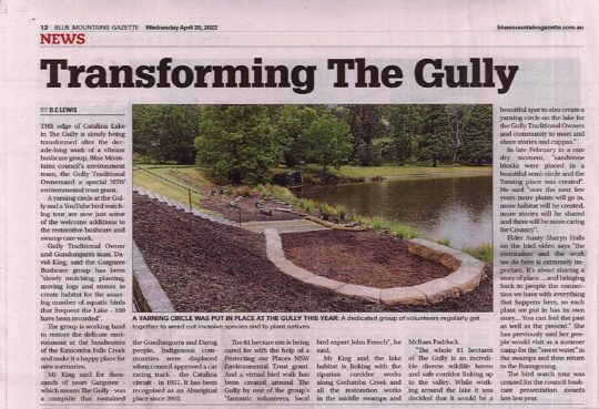
Council’s press release in the local Blue Mountains Gazette newspaper on page 12, dated 20th April 2022.
This press release states that this new stone yarning circle on..
“the edge of Catalina Lake in The Gully is slowly being transformed after the decade-long work of a vibrant bushcare group, Blue Mountains council’s environment team, the Gully Traditional Owners and a special NSW environmental trust grant…. a yarning circle at the Gully and a YouTube bird watching tour are now just some of the welcome additions to the restorative Bushcare and Swampcare work.”
A stone yarning circle being part of restorative bushcare? Seriously?
Council previously had approved three similar stone circles nearby in The Gully back in 2008. That’s where an external grant of some $600,000 went – on an Aboriginal-only interpretative history path.
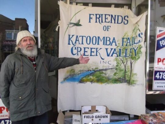
Sure, the dedicated group of volunteers of Garguree Swampcare Group who frequently convene in The Gully to weed out invasive plant species and plant out locally native plants do certainly effect restorative bushcare. The group formed a decade ago back in 2011 under the New South Wales Government’s Landcare NSW umbrella (not Council’s). As a local, the regenerative on-ground results of this volunteer group’s Swampcare efforts are readily observed by one walking around The Gully, especially noted inside the Dunlop Corner section of the old racetrack with the removal of all the blackberry and cotoneaster and the landscaping and planting out our of locally native plants and trees.
Former members of ‘The Friends’ would be well pleased that the native habitat restoration in this creek valley has continued since 2011. Yet sadly, no mention is made of the 27+ years of the Friends of Katoomba Falls Creek Valley Bushcare Group [1989 – 2016] and their related subgroups who continue to work in adjacent McRae’s Paddock and Selby Reserve, contributing many thousands of volunteer hours weeding The Gully of invasive plant species. Let the truth be told.
The Habitat Advocate has been based in The Gully Water Catchment since 2001 and over the two decades we have become very familiar with this rather special creek valley. Our editor walks around it weekly for exercise and peace of mind in Nature, not just the old racetrack, but south from the aquatic centre through MacRaes Paddock, Selby Reserve and to Katoomba Falls. He observes the goings on – the creek health, the landslips, continuing off-leash dog walkers, and the incremental new housing replacing the bushland along Wellington Street, etc.
Council’s press release states that the group’s volunteer co-ordinator David King (being a son of a former Gully resident) has been..“slowly mulching, planting, moving logs and stones to create habitat for the amazing number of aquatic birds that frequent the Lake – 100 have been recorded..The group is working hard to restore the delicate environment at the headwaters of the Katoomba Falls Creek and make it a happy place for new memories.”
The Habitat Advocate supports David King’s Swampcare leadership, wholeheartedly.
Council’s press release goes on…
‘Mr King said for thousands of years Garguree – which means The Gully – was a campsite that sustained the Gundungurra and Darug people. Indigenous communities were displaced when council approved a car racing track – the Catalina circuit – in 1957. It has been recognised as an Aboriginal place since 2002.
The 81 hectare site* is being cared for with the help of a Protecting our Places NSW Environmental Trust grant…Mr King said the lake habitat is linking with the riparian corridor works along Gedumba (sic) Creek and all the restoration works in the middle swamps and McRaes Paddock. The whole 81 hectares of The Gully is an incredible diverse wildlife haven and safe corridor linking up to the valley. While working around the lake it was decided that it would be a beautiful spot to also create a yarning circle on the lake for the Gully Traditional Owners and community to meet and share stories and cuppas.”
Garguree Swampcare has previously won the prestigious regional Indigenous Land Management Landcare Award in 2017.’
[* Editor: “81-hectare site?”
The Gully Water Catchment covers 290 hectares/2.9 km2 Dr Fred Ball’s 1993 Plan. So, Mr King’s 81 hectares represents a tiny 28% remnant of the creek valley’s water catchment area. However in fact, Blue Mountains {city} Council’s 2021 Plan at page 17 states the land area is 73.1 hectares as per the extract below, not 81 hectares; that is, unless Council’s doing another sneaky ursurp of its zoned community lands?…]
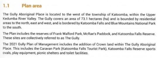
SOURCE: ‘The Gully Aboriginal Place of Management’, 2021-10-04, Section 1.1 Plan Area, page 17, by Blue Mountains {city} Council, with input by The Gully Traditional Owners, and funded by the NSW Government.
Again, The Habitat Advocate supports this habitat restoration endeavours wholeheartedly. But the timing of Council’s yarning circle is apposite. It took place during the period between July 2018 and October 2021 when Council was undertaking a revision of its 2004 Plan of Management for The Gully Aboriginal Place. Yet in both Council’s 2004 plan and subsequent 2021 plan, ‘yarning circles’ were not suggested, discussed, featured, nor budgeted for.
Instead, Council’s latest ‘yarning circle’ in The Gully seems to be some unplanned whim from grant funding undisclosed and outside any of the now 19 plans for and reports on The Gully. Maybe it was some bureaucrat’s whim within council with connections to the Parks Service to utilise excess stone blocks over-ordered for heli-upgrading of nearby hiking tracks in the national park. Voilà, another Council stone yarning circle crops up!
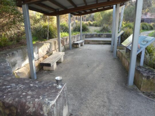
Anyway, so today we checked out this Council’s yarning circle down by the old artificial dam; a ten minute walk each way and took a few photos of it. Currently in the depth of winter, sitting on these fifteen cold hard sandstone blocks for too long would likely bring on a bout of haemorrhoids, so wise to bring a rug or two. The following photo was taken from the steps leading down to the lake, which originally provided the main access for swimming in the 1940s and 1950s before Council built its aquatic centre. Note the old changing sheds in the background.

Council’s transforming urbane vision in February 2022: It’s priority ‘yarning circle’ due to be just as another unused white elephant like Council’s $6 million concrete amphitheatre installed at Echo Point in 2019, save for PR media releases. [Photo by Editor, 2022-08-03]
Now this new ‘yarning circle’ is situated right by existing picnic tables on the lawn area behind next to the old racetrack and these serve to provide quite adequate seating for picnicking and if you like, some yarning. So it is an extraneous folly indeed.
For some reason Council in its wisdom, also recently decided to remove the only rubbish bin on this side of the lake.
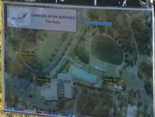
Council’s notice on the old racetrack near the lake
This is possibly because there is no Council ranger assigned to empty it. Instead there is a bin at the Madge Walford Fountain carpark side of the lake, and two of Council’s aquatic centre car park, meaning Council’s ranger now doesn’t have to walk far from his/her car to empty them – must be to do with OH&S walking.
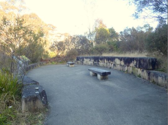
Speaking of safety, the site of this yarning circle is just metres down slope from a small freshwater spring that causes the grass in the vicinity to be constantly boggy. The site was originally a sedge swamp within the original natural riparian zone of the central creek; that is, before the artificial lake was constructed. The problem is that constant ground water seepage drains around and down the only steps leading to this new yarning circle below.
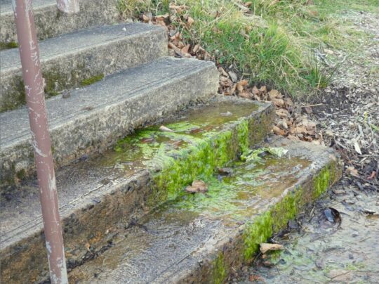
Concrete steps down to Council’s new stone yarning circle #4: Perennial spring ground water here causes moss to grow on the only downward step approach to the yarning circle, so creating a public trip hazard. Council is known to manage occasional grant funding for PR purposes, but has form in neglecting regular maintenance. May be the contractor for the yarning circle on the day responsibly swept away the moss; alas only to return. Council has no interest in The Gully besides its mandatory legal compliance, timely PR on occasion for the local rag and its glossy brochures despatched to ratepayers with their rate notices.
This is simply local knowledge by those like The Habitat Advocate who know this creek valley intimately. But Council in its ivory tower mindset constantly chooses not to consult with locals knowledge about its actions in The Gully. Yes, Council must first legally consult with The Gully Traditional Owners (GTO) as custodians of The Gully Aboriginal Place, yet despite none living within ‘Cooee!‘ of The Gully.
But the GTO would not have designed this folly and not at this location. When the interpretative walking pathway was designed, a primary feature was to enable disabled access so the pathway and boardwalks were all pre-designed to facilitate wheelchair access throughout.

The Gully’s interpretative pathway is wheelchair friendly so that it is accessible to anyone with a physical disability and mindful of the former residents (pre-1959) who are elderly to access this pathway – such a thoughtful design gesture. But the funding did not come from Council’s Environmental Levy as the now deteriorated sign to the right claims. It cam from a NSW Government Grant of $600,000 in 2008.
Key problem with this Interpretation Pathway biasely tell an Aboriginal-only story, not the true account about dispossessed poor folk who were Black and White and mixed. Council funded any of it, rather all the funding was external – NSW Government and Rous Water in the Northern Rivers region. Council did not seek or obtain a development application. Council did not seek or obtain any local community consultation, but only from the Gully Traditional Owners who were by 2008 usurping control in all decision making of The Gully to the deliberate exclusion of all other locals. Council deliberately and hatefully ostracised The Friends of Katoomba Falls Creel Valley Inc., who had undertaken considerable bushcare rehabilitation and lobbied Council since 1989 to protect this creek.
Council did not seek or obtain a development application. Council received no official clearance. It just thought it up and did it.
Sound familiar?
Apocalypse Now quote:
“Kurtz staged Operation Archangel with combined local forces, rated a major success.
He received no official clearance. He just thought it up and did it.
What balls.
They were gonna nail his ass to the floorboards for that one.
But after the press got a hold of it, they promoted him to full colonel instead.
Oh, man, the bullshit piled up so fast in Vietnam, you needed wings to stay above it.”
^https://movie-sounds.org/war-movie-sound-clips/quotes-with-sound-clips-from-apocalypse-now/he-received-no-official-clearance-he-just-thought-it-up-and-did-it
Former residents of The Gully (pre 1957-59) are elderly and many are observed by this author as being physically disabled, having attended a number of invited gatherings with former residents in The Gully. This points to this ‘yarning circle’ down by the lake, accessible by only by the steps, as being is a Council thing and likely contrived by some person without knowledge in perhaps Council’s PR department or by another one of Council’s external consultants driven in from distant Sydney.
Since at least 1981, a whole series of plans and reports to local Blue Mountains {city} Council on this creek valley have prescribed many environmental rehabilitation actions to be undertaken throughout. However precious little has been done by council as the custodial land manager. For instance, the ‘Bell Report’ of 1993 (plan #8) to Council on this creek valley in its executive summary on pages 6 and 7 identifies some sixty recommended actions for this creek valley of varying priorities as part of a prescribed environmental management plan. [Read More]. Had Council acted upon these recommendations then the Gully would have been truly transformed back to approximating its original ecological landscape and health as it was before the colonising usurpation since perhaps the mid-1800s.
Neither the Bell Report nor any of the 19 plans/reports (at least) on this creek valley include any ‘yarning circle’ nor ‘stone circle’, nor even a ‘crop circle’.
Council holds a condescending penchant for installing ‘yarning circle ‘follies for Aboriginal use, with now three in The Gully and one at Echo Point. So where’s this nutty motivation coming from?
Blue Mountains {city} Council has already approved three other such stone block gathering places or ‘yarning circles’ in The Gully. These were part of its approval in 2008 for an Aboriginal interpretative meandering pathway concreted inside its terminated Catalina Park motor racing circuit. It serves to showcase the history of prior Aboriginal residents of The Gully – which Council forcibly evicted between 1957 and 1959 for its motor racing mates.
Evidential of the truth, Council’s meeting minutes recorded this back in 1959:
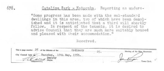
Truth telling
So why the need for a fourth stone circle in The Gully? And why position it adjacent to an invasive dam that was built by non-Aboriginal people over the top of the pre-existing riparian zone of the creek?
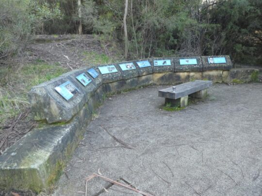
Here we show Council’s other three ‘stone circles’ in The Gully.
Stone Yarning Circle #1 – Notice how blackened the sandstone has become over time to moisture attracting mould in the wet pervious sandstone after 14 years and the lack of Council maintenance. Not exactly an aesthetically welcome look now
Stone Yarning Circle #2. Actually this is the site where in 2001 Council provided dump truck access so the RTA could dump hundreds of tonnes of sand and rock fill on top of The Gully sedge swamp from its highway cutting at the Soldiers Pinch bypass excavation project near Mount Victoria. More black mould neglected by Council.
Stone Yarning Circle #3. More black mould neglected by Council. We predict Council’s latest fourth yarning circle will similarly deteriorate in a few years time due to its record of ignoring maintenance.
The invasive non-Aboriginal history of this creek valley
Council’s stone ‘yarning circle’ is artificial just like the artificial lake adjacent. It is pure aesthetics and seems to be a public relations ploy by Council to showcase: “Look, Council is actually doing something constructive in The Gully!”
But Council’s latest haemorrhoid yarning circle achieves precious little in rehabilitating the riparian zone habitat of this decades-long neglected and abused creek valley.
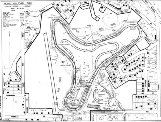
For starters, the lake adjacent is actually a dam that was constructed post-WWII over the top of the old ‘Frogs Hollow’ spring/swamp riparian area of Katoomba Falls Creek by local tourist entrepreneur at the time, one Horace Gates. It was part of his grand scheme to impose a carnival amusement park called ‘Catalina Park’ in the valley.. offering ‘every facility for fun and food’.
Horrie in 1948 seconded the shell of an old Catalina PBY-5 flying boat for his new dam as a unique tourist attraction to his amusement park. By 1949 he arranged for local council to supply 100,000 gallons of water for it, metered at 1/6d. per thousand litres. [Council of the Blue Mountains meeting minute :’Supply of Water to H. Gates for Catalina Park’, dated 11th January 1949, 7 pm, page 3.]
Horrie also paid £500 towards the £2,500 cost of constructing new Plantation Street westward between Cascade Street and his Catalina Park that same year. [Council of the Blue Mountains meeting minute :’Plantation Street: Katoomba’, dated 15th February 1949, 7:30 pm, page 183.]
Horries’ new ‘Catalina Park’ subsequently served to provide various attractions and activitioes including speedboat rides, tearooms, miniature train, a Ferris wheel, merry-go-round, swimming pool and a Giggle House showing Charlie Chaplin films.
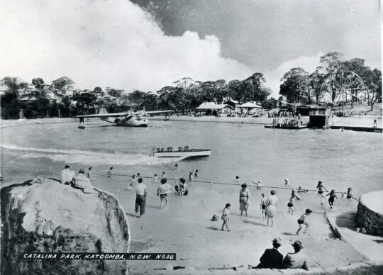
Horace Gates’ Catalina Park circa 1950. This was during summer of course, since the water temperature can get down to 4o degrees celsius in winter months. The concrete steps to the now stone ‘yarning circle’ would be off picture to the right.
Horrie also locally owned an amusement parlour on the north-west corner of Katoomba and Waratah Streets, as well as his ‘Homesdale Guesthouse‘ at 207 Katoomba Street including its Wentworth Cabaret nightspot downstairs. Subsequently the guesthouse was replaced to become the much larger Katoomba Corps branch of the Salvation Army, then in 2021 it was converted into backpacker accommodation of international Youth Hostels Association (YHA).
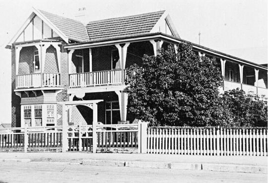
Homesdale Guesthouse in the 1920s. Horrie wasn’t exactly short of a few bob and had influence on Council to acquire the portion of The Gully he named Catalina Park in the post-war 1940s.
Katoomba tourism was Horrie’s thing 1920s into the 1950s. He was a relatively successful entrepreneurial businessman of Katoomba. But he used his wealth to be one of the many usurpers of The Gully.
But Horrie cared not for the welfare or quite enjoyment of the adjacent residents of The Gully. They were mostly Aboriginal impoverished families subsisting in meagre self-made shacks in the bush with no utilities – having no running water, no electricity, no gas, may be septic tanks pre-1907. Thereafter Council imposed town sewage be trenched throughout the creek valley, yet not connected to any of the Gully shacks (councillors didn’t want to encourage what they regarded as a shanty bush settlement on the edge of town).
A walking visit to The Gully these days reveals interpretative signage record of the simple subsistence living conditions that former residents endured before Council’s forced evictions and calling in the bulldozers 1957-1959.
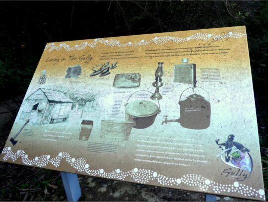
Living in The Gully was basic bush camping
May be there was one toilet block for the entire Gully if they were lucky. May be that tiny brick one below Wells Street, or was it a more recent addition for overnighting campers attending motor race meets later in the 1960s and 1970s?
By the early-1950s, Catalina Park as then an amusement park was pretty dated and run down. When Horrie died, Council named Plantation Street adjacent as ‘Gates Avenue’ and Horrie’s dam as ‘Catalina Lake’. Council in the 2000’s renamed a nearby short portion of Farnells Road as ‘Catalina Avenue’ as an appeasement gesture to the petrol-head fraternity bemoaning Council’s 2002 closure of their Catalina Park motor racing circuit just by the lake.
This use of The Gully was all entirely non-Aboriginal use and exploitation by wealthy outsiders – the amusement park (1946-1950s) followed by the raceway (1957-2001). So the pertinent question in relation to this fourth stone yarning circle by Council is why spend money complementing an unnatural part of The Gully. This is just another whim, indeed a folly.
Who’s idea was it? How much did it cost? Why did this civil works project take priority over many other priority ecological rehabilitation actions in the valley as prescribed by many plans of management since at least 1981? Surely, given the latest Plan of Management of October 2021, the use of that “special NSW environmental trust grant” as quoted in the newspaper article, should have applied to the action items listed in that plan. The 2021 plan lists a mere 6 action items on page 111. , just 10% of the 1993 plan.
In comparison to the 1993 plan of management’s 60 recommended action items, Council’s 2021 plan list a mere 6 ‘governance actions’ on page 111 budgeted to cost $54,950. How much did this fourth stone yarning circle project cost? On page 113 indicates a massive budget of $4,742,910 to implement the latest plan of management. But this list is not about habitat restoration of The Gully, its all about human usage as the following cost summary reveals:
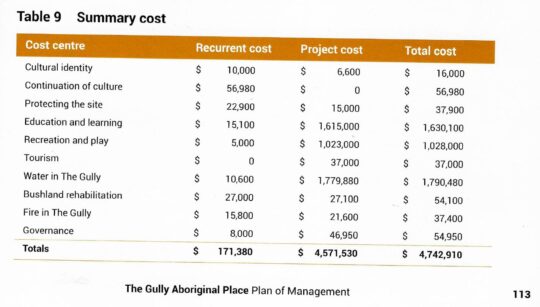
Truth telling: The Gully Aboriginal Place 2021 Plan of Management
Council’s 2021 plan includes a pie-in-the-sky budget totalling a massive $4,742,910. Co-incidentally Council’s 2004 plan budgeted a similar $4,682,000. Didn’t happen.
Council’s 1996 (Connell Wagner) Plan listed many distinct habitat restoration focuses and action plans for each portion of the creek valley, then respectively named Frank Walford Park, McRaes Paddock, Katoomba Park, and included Katoomba Golf Course. Featured in all four portions included regenerating of re-vegetation degraded areas and rehabilitating swamps and bushland. Budgeted total costs came in at $794,500.
Didn’t happen.
Council’s 2021 plan won’t happen. This latest plan is set to be mothballed by Council again, because like the 18 previous reports and plans on this riparian valley, the 2021 plan contains the usual escape clause to allow Council to do again nothing in The Gully. A funding excuse. Council is legally compelled by the New South Wales Government to prepare a plan of management for a public (community) land it controls/owns such as The Gully, but Council in its history is yet to seek the requisite budgeted external funding for any plan for The Gully in order to complete the recommended action items.
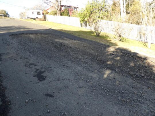
May we suggest to the insular thought bubble that is Blue Mountains {city} Council that rather than it have imposed a 4th Celtic yarning circle in The Gully for the rarely seen Aboriginal folk around, that Council instead focus its cash on more pressing public safety measures in and around The Gully?
Below is one such pressing public safety problem deserving Council’s prompt maintenance.
It’s possibly the largest pothole currently besetting the Blue Mountains at some 4×2 metres in size!
It’s situated down the very steep road of Warriga Street on the eastern approach to The Gully. Such being the months of this pothole’s deterioration, one almost needs 4×4 vehicle to currently negotiate through it!
Further Reading:
[1]
Garguree Swampcare Group, ^https://garguree.bushcarebluemountains.org.au/
[2]
Catalina Park (motor racing circuit 1961-2001), ^
https://www.racingcircuits.info/australasia/australia/catalina-park.html
[3] (
Photos of Catalina Park), Blue Mountains Library, ^
https://www.flickr.com/photos/blue_mountains_library_-_local_studies/2627033062/in/photostream/ | ^https://www.flickr.com/photos/blue_mountains_library_-_local_studies/2493550745
[4]
Catalina Park (amusement park 1946-1950s), Blue Mountains Local Studies, ^
https://bmlocalstudies.blogspot.com/2010/06/catalina-park-katoomba.html

 Loading...