Author Archive
Tuesday, November 12th, 2013
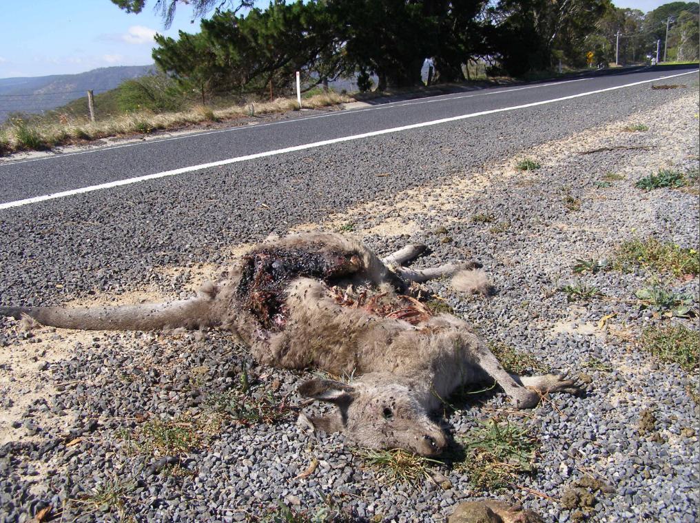 Australian roadkill on the Jenolan Caves Road to Oberon
west of the Blue Mountains, New South Wales
[Photo by Editor 20131109, © under ^Creative Commons] Australian roadkill on the Jenolan Caves Road to Oberon
west of the Blue Mountains, New South Wales
[Photo by Editor 20131109, © under ^Creative Commons]
.
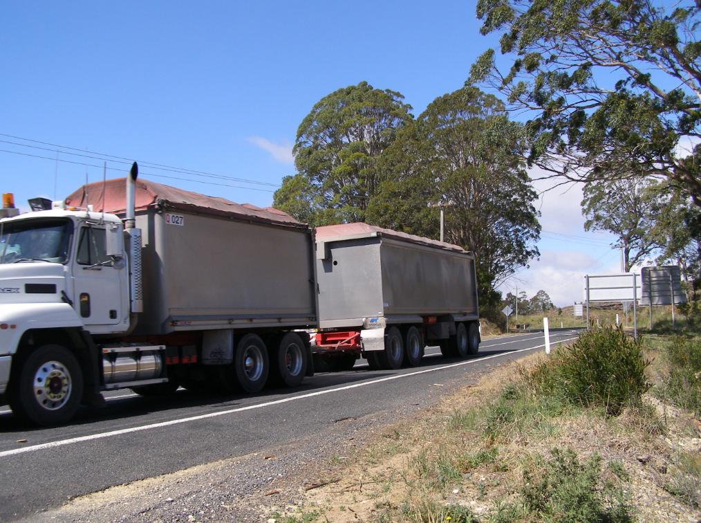
Taking the tourist drive out to Oberon last weekend, we must have counted two dozen dead, mangled and fly blown Australian animals along the roadside. Kangaroos and wombats mainly; and a few feral cats and foxes.
It was a bizarre ‘Welcome to Oberon’ along the Jenolan Caves Road and then along the Duckmaloi Road into the logging and quarry town of Oberon.
We first passed by Hytec’s Austen Quarry outside Hartley which carves into the hillside to produce road making aggregate crushed rock.
.
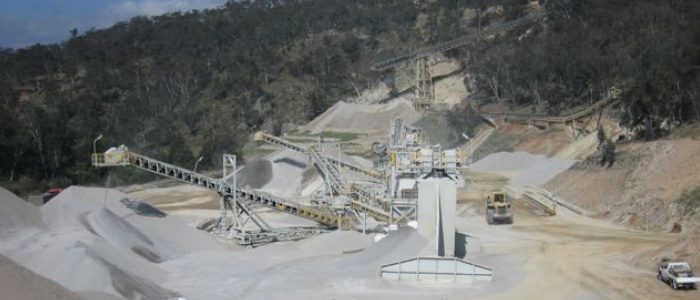 Hytec’s Austen Quarry
Jenolan Caves Road
[Source: ^http://www.hy-tec.com.au/products/Aggregates/austen.aspx] Hytec’s Austen Quarry
Jenolan Caves Road
[Source: ^http://www.hy-tec.com.au/products/Aggregates/austen.aspx]
.
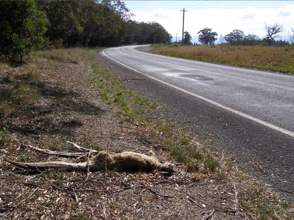
We passed by this fly-blown wombat grossly mangled by the massive B-double sand trucks.
.
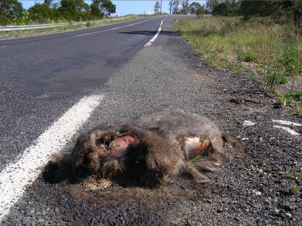 What’s left of a Wombat
Jenolan Caves Road
[Photo by Editor 20131109, © under ^Creative Commons] What’s left of a Wombat
Jenolan Caves Road
[Photo by Editor 20131109, © under ^Creative Commons]
.
The B-doubles hoon along as if racing motorbikes. We were tailgate bullied by one on the road out to Oberon. The B-double sand trucks travel through the night at speed and so the wildlife has no chance.
.
 Duckmaloi Road to Oberon
[Photo by Editor 20131109, © under ^Creative Commons] Duckmaloi Road to Oberon
[Photo by Editor 20131109, © under ^Creative Commons]
.
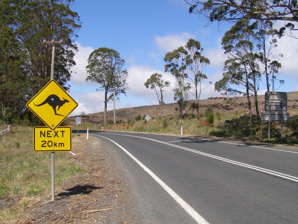 Kangaroo sign more of a token gesture
Situated on the Jenolan Caves Road opposite clearfell native forest.
[Photo by Editor 20131109, © under ^Creative Commons] Kangaroo sign more of a token gesture
Situated on the Jenolan Caves Road opposite clearfell native forest.
[Photo by Editor 20131109, © under ^Creative Commons]
.
 Less kangaroos next 20km
Jenolan Caves Road
[Photo by Editor 20131109, © under ^Creative Commons] Less kangaroos next 20km
Jenolan Caves Road
[Photo by Editor 20131109, © under ^Creative Commons]
.
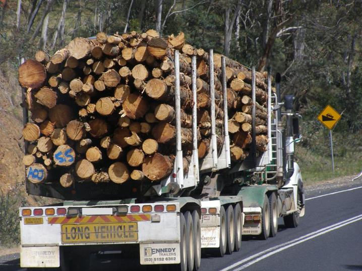 B-Double Logging Truck
Loaded up from Jenolan State Forest, along the Duckmaloi Road to Oberon’s Timber Mill
[Photo by Editor 20131109, © under ^Creative Commons] B-Double Logging Truck
Loaded up from Jenolan State Forest, along the Duckmaloi Road to Oberon’s Timber Mill
[Photo by Editor 20131109, © under ^Creative Commons]
.
One Oberon based tourism operator promotes things to do around Oberon thus:
“Explore the spectacular Blue Mountains High Country on horseback and quad bikes, ride beneath a canopy of pine forests, marvel at the unspoiled bushland, gaze into a crystal clear creek, breathe the clean mountain air.”
.
Sunday, November 10th, 2013
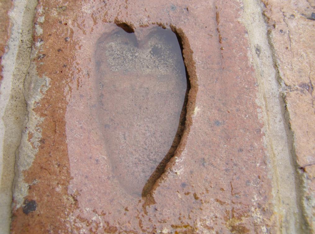 Our home’s lucky John Clew heart bricks, today full of drenching rain water
[Photo by Editor, 20131110, photo © under ^Creative Commons] Our home’s lucky John Clew heart bricks, today full of drenching rain water
[Photo by Editor, 20131110, photo © under ^Creative Commons]
.
It’s very wet. It’s actually soaking wet up here in the Blue Mountains. How welcoming are the rains? They took long enough. Poor bloody bush has been long parched out there; too parched, too tinder dry. Now the rains are over us and they are staying for while, and they can stay as long as they like.
Some dates stick in one’s mind. Friday 12th October 2012 is a date that I have personally etched into my memory. It was the day that constant snow suddenly blanketed the Upper Blue Mountains out of nowhere. The snow on the ground was a foot thick and we lost tree branches to the weight of it. It was a memorable Friday, as it no longer snows up here.
Apparently, it used to snow most winters in the Upper Blue Mountains. Living memory recalls that a few opportunistic locals even once skiied down Katoomba Street during Winter Magic.
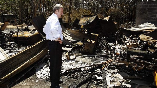
Residents of the townships of Winmalee and Mount Victoria in the Blue Mountains will now remember Thursday 17th October 2013, but not for happy times. It was an awful day. For those affected and involved likely the worst ever. Out of nowhere separate wildfires suddenly ravaged through their communities and took away many homes and memories.
I have happened to drive past Linksview Road involuntary over recent days. Passing by incinerated homes just off the side of the road feels voyeuristic and so immoral. Luck is perhaps a curse, like pretending routine life-as-usual between others’ total loss. No way.
None of it’s fair to anyone affected or not affected but no less it about Mountains folk not knowing what to say or do for the blackened ruins down the street. Nothing wrong with outpouring and I think it is a right.
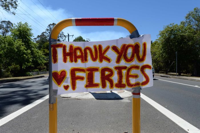
Only the firies know it could have been worse.
And I shouldn’t have driven down St Georges Parade yesterday on the way home, but I wanted to just to know the trauma hidden off limits by the authorities. Now its incinerated street and homes haunt me. I walked this street just after the 2006 Grose Fires, observing the hazard reduction above Lawsons Long Alley. Many new homes on a no through road ridge nestled above Blue Mountains bush. Bloody lucky then.
I awoke very early this morning realising how lucky I am as one of the 99.9% of Blue Mountains residents with a home, just as per usual. For us it is life as usual and we have rain on our roof. It is because we have a roof and a house.
Over three hundred residents this time on the morning of the 17th October did too like me, but since then they no longer do. I can’t imagine the ravage and the total loss. But I write this because catastrophe needs to be said because it is just that. All Blue Mountains people need to be affected by the incinerated homes down sealed off crime scene streets that could have been theirs.
If I had lost my home, I expect that I would not be in a state to write coherently, but I am so I choose to because I take an active interest. I witnessed wildfire threaten my home in 2001, seeing my garden hose drizzle to a horrifying dribble rendering me castratingly helpless and useless. I have taken an empathetic very personal interest in bushfire threats ever since.
My father lost his entire family records in a garage fire when I was 18. He was probably devastated at the time, but I don’t recall him expressing or showing grief because he was probably brave facing to us kids and probably because of my immature age. Over time he realised that the now and family are most important to one’s life. He has re-affirmed this over the subsequent years, with time and with a strength of family to move on. Sounds easy and simple in hindsight, but hindsight is what the memories are about, and as part of our survival instinct we tend to recall in most detail the good times, and confine the bad times to snippets.
Now that today, three week’s hence the rains are over us, I can happily stand under them and get happily soaked quite eccentrically for all it matters. So what matters at the end of the day when the sympathy has packed up and move on?
It is about why we made the choice and it was a soul thing. We live for hope and so we should. We live in the Blue Mountains because we choose because the Mountains are a special place for reasons us here know.
Bless you.
.  A memorable sunny day at a Blue Mountains Winter Magic
[Photo by Editor, 20080621, photo © under ^Creative Commons]
.
It is 2013 and we are to become wise, in our own time.
.
Tuesday, November 5th, 2013
 “This will be as bad as it gets”
So we kicked ass better than the Victorians in 2009,
we only had two deaths “This will be as bad as it gets”
So we kicked ass better than the Victorians in 2009,
we only had two deaths
.
The State Mine Bushfire
.
On Wednesday afternoon 16 October 2013, government Defence Force recklessly over-indulged in a live munitions exercise at the Marrangaroo army range. The range is situated on the outskirts of the town of Lithgow, New South Wales, upwind of the Greater Blue Mountains World Heritage Area. The exercised directly sparked a fire in dry grass on the range. Fanned by strong, hot, westerly winds it rapidly moved eastwards to the forested hillside on the northern side of Lithgow.
The fire spread into bushland and over the following week extended out of control burning out most of the northern region of the Blue Mountains National Park, parts of Wollemi National Park, and triggered the evacuation of most of the Lithgow region. The communities affected included Bell, Berambing, Bilpin, Clarence, Dargan, Hartley Vale, Lithgow, McKellars Park, Mount Irvine, and Mount Wilson. The fire burnt out more than 55,000 hectares (140,000 acres) between Lithgow and Bilpin.
Rural Fire Service Dad’s Army suppression delays meant that instead of waterbombing a small grassfire on the 16th, what was allowed to grow into a massive wildfire front saw fire bombing of vast hillsides in a multi-flank head burning response. Many more thousands of hectares of bushland habitat in and around the Greater Blue Mountains World Heritage Area were incinerated. But the total area of fire impact has not been made public by the RFS.
During that week fighting fires across New South Wales, two men tragically died. A 63-year-old man suffered a heart attack while fighting a fire at his home at Lake Munmorah on the Central Coast. Agricultural Pilot David Black, 43, from Trangie in the Central NSW died when his Dromader aircraft crashed while contracted to the RFS to waterbomb the Wirritin Ridge Bushfire in the Budawang National Park.
.
<< ”This will be as bad as it gets,” Rural Fire Service Commissioner Shane Fitzsimmons said. ”On days like [this], there’s a very real potential for more loss of homes and life. There’s is real potential for more homes and lives lost on Wednesday, says the NSW Rural Fire Commissioner.
 RFS Armageddon RFS Armageddon
.
Weather worse than the extremes already predicted, combined with large bushfires burning out of control, and the real potential for others to spark up, have prompted a very grim warning. The RFS had warned since the weekend about the potential devastation Wednesday’s weather could cause but the revised forecast on Tuesday was even more worrying, Mr Fitzsimmons said.
Wednesday would be hotter, drier and windier than the dire predictions previously forecast, posing a grave challenge to one of the largest firefighting contingents assembled in NSW history. They would have to battle an active 1500-kilometre fire edge in the Blue Mountains where three major fires, one at Bilpin now linked to the second at Mount Victoria and a third at Springwood, burned out of control. ”It’s a difficult, dynamic, dangerous fire-ground situation,” Mr Fitzsimmons said. >>
.
[Source: ‘This will be as bad as it gets’: Blue Mountains fire crews prepare for the worst‘, 20131022, by Nick Ralston, Emma Partridge, Sydney Morning Herald, ^http://www.smh.com.au/environment/weather/this-will-be-as-bad-as-it-gets-blue-mountains-fire-crews-prepare-for-the-worst-20131022-2vz3h.html]
.
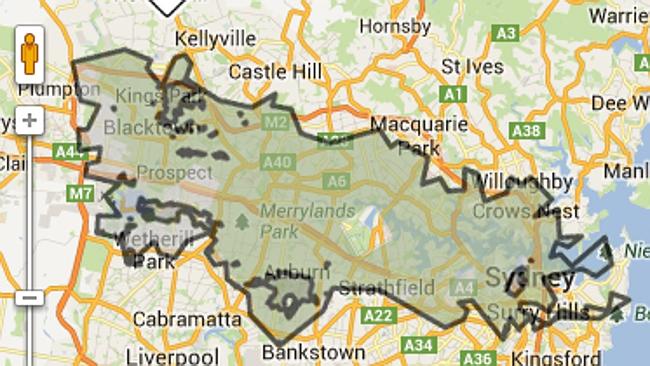
 RFS Homebush doing staged PR shoot…when?
.
<< Two weeks after the worst of NSW’s bushfire emergency, the O’Farrell Government is refusing to say whether it will consider burying power lines in fire-prone areas or buy back properties razed in risky locations – key responses to the Black Saturday fires.
The Rural Fire Service says a power line started a blaze that jumped a road and then engulfed almost 200 houses at Springwood, Winmalee and Yellow Rock in the Blue Mountains on October 17.
Fallen or damaged power lines caused most of the 173 deaths in Victoria’s Black Saturday disaster of 2009. After the royal commission on those fires recommended action to address overhead power lines, the state government announced a $1 billion plan to replace them with underground cables.
That royal commission also recommended the government buy back houses in areas at extreme fire risk, and Victoria has spent $25.6 million on 116 properties. Some of the land will be sold to surrounding neighbours, who will use it as a buffer between the bush and their homes.
On Tuesday, Fairfax Media sent specific questions about power lines and property buy-backs to Emergency Services Minister Mike Gallacher. The Planning Department responded but did not address the questions, instead saying NSW had the toughest bushfire planning approvals regime in Australia.
When pressed on the need for a ministerial response, his spokesman said: ”The priority of this government at this point in time is responding to both the uncontained fires still burning across the state and the high winds this afternoon.”
When the same questions were put to Mr O’Farrell’s office on Thursday, it responded with a statement the Premier made that day in Parliament. “After events such as these there are always lessons that can be learned and applied to the future and we are determined to do so,” Mr O’Farrell had said.
”There are several investigations under way into the fires. The government will closely examine the work of those investigations.”
The statement made no mention of the lessons of Black Saturday. >>
.
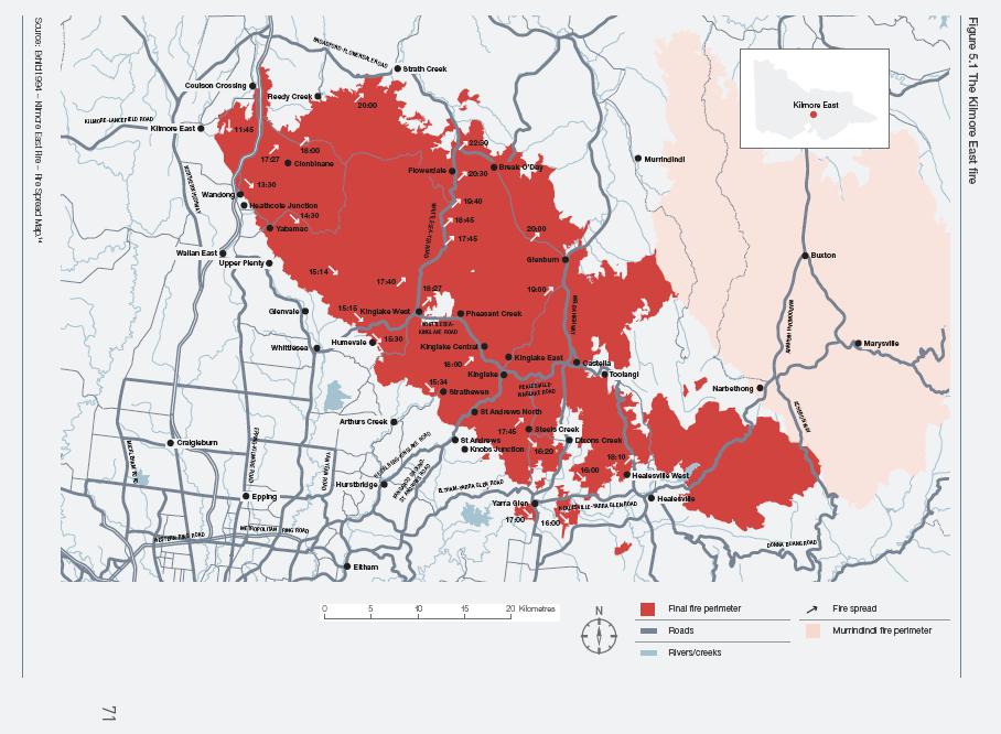 Kilmore East Fire Victoria
Started by Government neglect on 7th February 2009 Kilmore East Fire Victoria
Started by Government neglect on 7th February 2009
.
 Comparative scale of the State Mine Fire (Lithgow, NSW)
Started by Government neglect on 16th October 2013
..that diverted critical firefighting resources from Winmalee Comparative scale of the State Mine Fire (Lithgow, NSW)
Started by Government neglect on 16th October 2013
..that diverted critical firefighting resources from Winmalee
.
.
[Source: ‘O’Farrell fans flames of frustration as experts warn it is time to act‘, 20131103, by Rick Feneley, News and features writer, Sydney Morning Herald, ^http://www.smh.com.au/federal-politics/political-news/ofarrell-fans-flames-of-frustration-as-experts-warn-it-is-time-to-act-20131102-2wtdq.html]
.

.
Sunday, November 3rd, 2013
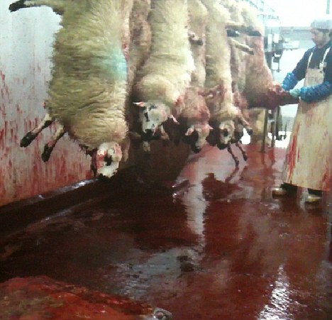
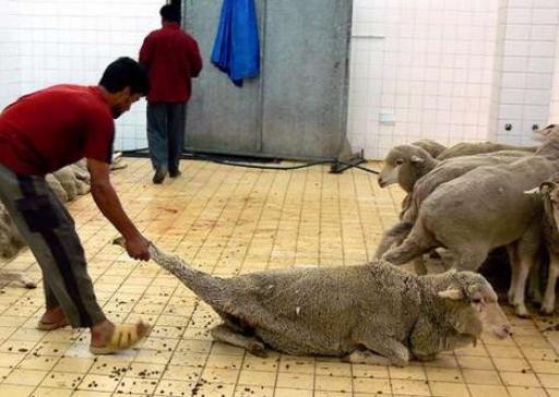
Australian live sheep endure halal torture in a Kuwait livestock market, October 2013
[Source: Animals Australia, ^http://www.banliveexport.com/take_action/kuwait-sheep-sold-illegally/]
.
<< On streets, in backyards and in back rooms at markets, countless sheep, during the Festival of Sacrifice, endure the agony of having their throats cut whilst fully conscious. Often killed by untrained hands, there’s no guarantees of a quick end to their suffering.
In the week leading up to the Festival of Sacrifice, Australian sheep were again found being illegally sold from a notoriously cruel livestock market in Kuwait.
They were destined to be sold to individual buyers for ‘sacrificial’ slaughter.
This very market was the scene of some of the most distressing and confronting cruelty that Animals Australia has ever documented. In 2010 our investigators gathered evidence of sheep being dragged, thrown, trussed and stuffed into car boots, tied onto roof racks and having their throats brutally cut – all while fully conscious.
https://www.youtube.com/watch?feature=player_embedded&v=G0Vmx0n6QYg
‘Strict’ live export rules were meant to protect animals from this fate.
But this is the third time Animals Australia investigators have found sheep in this market. Fourteen months ago we lodged our first complaint with the Department of Agriculture. As a result they imposed additional conditions on the export licences of the three exporters who sent Australian animals into Kuwait.
This footage was taken at Al Rai market in August 2012, and sparked Animals Australia’s first complaint to the Department of Agriculture:
.
.
Despite the additional conditions placed on the exporter, when our investigators returned in February this year, Australian sheep were STILL being offered for sale from this marketplace. A second complaint supported by extensive evidence was lodged and this investigation is still ongoing – nine months later.
Again, in October this year, Australian sheep were still there. This time on the eve of the Festival of Sacrifice – the peak time of animal cruelty and suffering in the region.
Regulations will continue to be disregarded and animals will continue to suffer unless the exporters responsible face severe penalties for breaches. >>
[Source: ‘Sheep suffer as exporters break rules again’, Aussie sheep endure cruel slaughter in Kuwait livestock market, Animals Australia, Oct 2013]
.
<< Sydney-based Halal Certification Authority Australia chairman Mohamed El-Mouelhy, Australia’s leading halal certifier, said it was impossible to stop people in the Middle East slaughtering animals at home or in the street.
“It’s part of the culture, and this is something that everyone has to do to give two-thirds to the poor and one-third they keep,” he said.
Fahad Saddique, manager of the Al Yasin halal butchery in Sydney’s Lakemba has called on animal-rights activists to show greater religious and cultural tolerance over live exports.
Australia’s Agriculture Minister Barnaby Joyce has conceded cruelty to exported livestock could not entirely be wiped out. Australia’s Prime Minister Tony Abbott says only “very foolish governments” make “policy on the run on the basis of one or two media reports”.
Animals Australia Lyn White said the problem was not religious, but simply about animal cruelty:
“This case is first and foremost about an Australian export company which has broken the law and whose ongoing disregard for Australian regulations in Jordan should attract the strongest sanctions. Australian export requirements permit halal, fully conscious slaughter, but they state that it needs to occur in abattoirs with appropriate infrastructure and trained workers so that the risks of cruel treatment are reduced.
The on-selling of Australian animals to private buyers for slaughter was strictly banned because of the welfare repercussions, especially during religious festivals. Animals Australia said 10,000 Australian sheep were sold outside the current Exporter Supply Chain Assurance Scheme introduced to make exporters responsible for animal welfare throughout the supply chain. >>
.
[Source: ‘Call for cultural tolerance over live exports as activists release film’, by Lauren Wilson, Rachel Baxendale, Jared Owens, The Australian (newspaper), 20131101, ^http://www.theaustralian.com.au/national-affairs/policy/call-for-cultural-tolerance-over-live-exports-as-activists-release-film/story-fn59nm2j-1226750892608]
.
 Most chain fast food outlets in Australia now stipulate that only Halal tortured animal meat be served in their stores
Buy Maccas, KFC, Hungry Jacks, Subway, Sumosalad, or any kebab takeaway and so condone halal torturing of livestock animals. Most chain fast food outlets in Australia now stipulate that only Halal tortured animal meat be served in their stores
Buy Maccas, KFC, Hungry Jacks, Subway, Sumosalad, or any kebab takeaway and so condone halal torturing of livestock animals.
.
.
.
Further Reading:
.

.
[1] Animals Australia, ^http://www.animalsaustralia.org/
.
[2] Ban Live Export, ^http://www.banliveexport.com/
.
[3] Get Up, ^https://www.getup.org.au/campaigns/animals/live-export/
.
[4] World Society for the Protection of Animals, ^http://www.wspa.org.au/wspaswork/liveexport/
.
[5] Australian Government’s official encouragement of live animal export, ^http://www.daff.gov.au/animal-plant-health/welfare/export-trade
.
Saturday, October 12th, 2013
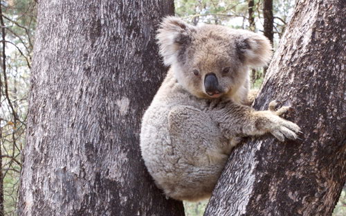
 Ecological consultant David Paul with a koala found in the Leard State Forest
[Source: Photo by Tania Marshall, Front Line Action on Coal,
^http://frontlineaction.wordpress.com/] Ecological consultant David Paul with a koala found in the Leard State Forest
[Source: Photo by Tania Marshall, Front Line Action on Coal,
^http://frontlineaction.wordpress.com/]
.
Environmentalists are urging the New South Wales and Australian governments to save the Leard State Forest. They are concerned about the catastrophic impact of major mining expansion on an isolated and vulnerable koala colony in its natural habitat within the Leard State Forest.
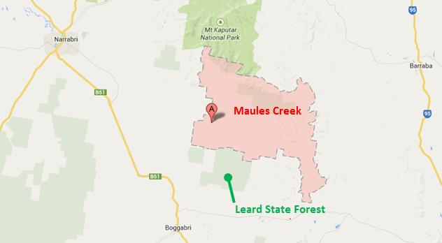
The Leard State Forest is situated near Maules Creek within the Namoi River catchment about 10km north-east of the township of Boggabri on the North West Slopes of New South Wales, about 500km nor’-nor’-west of Sydney.
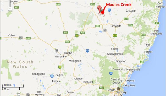 Maules Creek Mine location map
[Source: Google Maps] Maules Creek Mine location map
[Source: Google Maps]
.
The nearby town of Boggabri lies on the Namoi River, a major perennial river and floodplain within the Murray-Darling Basin. The landscape is naturally subjected to infrequent seasonal rains and widespread flooding.
.
 . .
The native vegetation has been naturally dominated by Box-Gum Woodland ecological communities featuring the endemic species of White Box, Pilliga Box and Bimble Box. These provide vital habitat for numerous woodland bird and microbat species and a small community of Koalas.
 The Leard State Forest
An isolated remnant box woodland The Leard State Forest
An isolated remnant box woodland
.
The region was originally the Aboriginal land of the Kamilaroi people and their ‘place of many creeks‘. However, two hundred and twenty five years of colonial pastoral settlement and associated widespread deforestation has seen the region denuded of most native vegetation historically for sheep and wheat; and more recently for irrigated cropping, particularly water thirsty cotton.
.
 Box Woodland decimated for industrial scale cotton
The farming model is entirely artificially dependent river-diverted irrigation for export produce.
[Source: Promotional tourism advertisement by the NSW Government,
^http://www.visitnsw.com/destinations/country-nsw/moree-and-narrabri-area/gallery] Box Woodland decimated for industrial scale cotton
The farming model is entirely artificially dependent river-diverted irrigation for export produce.
[Source: Promotional tourism advertisement by the NSW Government,
^http://www.visitnsw.com/destinations/country-nsw/moree-and-narrabri-area/gallery]
.
Native habitat has been sadly reduced to a few isolated islands of land set aside as ‘State Forests’. These include the Pilliga Forest, the largest remnant temperate forest in Eastern Australia, as well as Jacks Creek, Plagyan, Rusden and Leard State Forests, as well as the rugged Mount Kaputar National Park.
Leard State Forest includes the most extensive and intact stands of the nationally listed and critically endangered Box-Gum Woodland remaining on the Australian continent and is home to nearly 400 native species of plants and animals, and includes habitat for 34 threatened species and several endangered ecological communities.
.
 Leard State Forest location map
[Source: Google Maps] Leard State Forest location map
[Source: Google Maps]
.
It’s believed as few as 20 koalas are left in the Leard State Forest, which is considered its primary habitat. The primary food source for the koalas is thought to be the Pilliga Box, Red Gums and Yellow Boxes. This Koala population is very fragile and could be significantly impacted on by the future mining plans.
Ecological consultant David Paul:
“If they are part of the same population as the Pilliga koala, then Leard is a very important area for allowing the dispersal of these animals in an east west direction. Leard Forest is a stepping stone between habitat in the Pilliga and to the east and south. While there are not many koalas there it’s a very important area to allow the dispersal of koalas in the region.”
 Koala in Leard State Forest
[Source: Photo by Tania Marshall, Front Line Action on Coal,
^http://frontlineaction.wordpress.com/] Koala in Leard State Forest
[Source: Photo by Tania Marshall, Front Line Action on Coal,
^http://frontlineaction.wordpress.com/]
.
.
Whitehaven Coal mining expansion into the Leard State Forest
.
<< Approval has been given for one of the biggest open-cut coal mines in the world in the state’s north-east. Whitehaven’s Maules Creek Project, near the Leard State Forest, will extract 12 million tonnes of raw coal a year.
If given the final go ahead from the Federal Government, Whitehaven expects production to start mid-2013, with operations predicted to last around 30 years.
Managing director Tony Haggarty:
“The mine will be good for the region economically and good for the state. It’s one of the best coal developments in the world. It’s a large reserve, it’s very good quality. It’s the sort of coal that is in demand in the market place, and because the reserve is large and because it has a long life, there will be a significant area of land involved.”
.
But Federal Environment Minister Tony Burke says the project will now face Commonwealth scrutiny. It will examine the mine’s potential impacts on the nearby critically endangered white box woodland.
An Environment Department spokeswoman says once the assessment is complete, it will go before Mr Burke who will consider the advice of the department, the Independent Expert Scientific Committee on possible water impacts, and any public comments.
Environmentalist Phil Spark:
“The planning commission’s approval is a blow to the endangered trees and animals that live in the forest. My biggest concern is that the environment has been totally undervalued. You just can’t destroy a forest and think it’s going to be compensated. It’s an endangered ecological community and it just can’t be replaced.”
The Maules Creek Project is about 18 kilometres north of Boggabri in the Gunnedah Basin. >>
.
[Source: ‘Go ahead for one of world’s largest coal mines’, 20121025, ^http://www.radioaustralia.net.au/international/2012-10-25/go-ahead-for-one-of-worlds-largest-coal-mines/1035960]
.
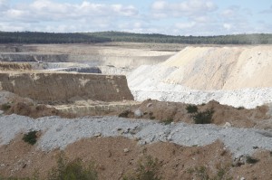 Nearby Boggabri Open Cut Coal Mine, owned by Whitehaven Coal
Saw thousands of hectares of native Box Woodland bulldozed in 2006. Nearby Boggabri Open Cut Coal Mine, owned by Whitehaven Coal
Saw thousands of hectares of native Box Woodland bulldozed in 2006.
.
Environmentalists are up in arms over a proposal to mine two thousand hectares of state forest, among it, this remnant koala habitat.
The Maules Creek Mine adjoining the Leard State Forest has received NSW government approval to expand into the forest, which will see most of the forest and its flora and fauna all but completed bulldozed into history.
Whitehaven Coal wants a new open-cut coalmine that will extract up to 13 million tonnes of coal a year to earn it $767 million. It also wants a second nearby Idemitsu Boggabri open cut mine to extract 7 million tonnes a year.
Greens Senate Candidate Cate Faehrmann:
“These approvals will literally change the face of the township of Gloucester as well as the small community of Maules Creek near Narrabri in the state’s north-west. The Maules Creek and Boggabri proposals were referred to the Federal environment minister Tony Burke because they are going to wipe out critically endangered forest which is home to many threatened species. How can any Environment Minister in their right mind approve this?
The Maules Creek coal mine alone will emit the same amount of carbon emissions each year as New Zealand during its proposed 30 year life span. This is disgraceful and it’s why communities everywhere are starting to call on the government to transition away from coal and towards a secure renewable energy future.
I have visited the site of the proposed Maules Creek coal mine recently to see the forest firsthand and saw a koala up close in the forest. Tony Burke has just approved a coal mine which will wipe out a small and vulnerable koala population
“The farmers who have been fighting coal mine proposals in Leard State Forest for years will continue to fight for the protection of their forest.”
.
Up until recently, Whitehaven Coal has been owned by multimillionnaire Nathan Tinkler. Its chief executive is Paul Flynn and one of its directors is former National Party leader Mark Vaile. In June 2013, after securing his Maule’s Creek Mine expansion approval, Tinkler sold off most of his shareholdings in Whitehaven Coal to an American profiteering investment capital firm, Farallon Funds.
Whitehaven Coal has been challenged in the courts against its proposal to mine the Leard State Forest by the Northern Inland Council for the Environment. This community based not-for-profit group has said the Federal government was wrong to approve the project. They are challenging the approval process of both the Maules Creek and nearby Idemitsu Boggabri coalmines “because of the dodgy process by which they were approved and the devastating impacts they will have”.
Whitehaven Coal chief executive Paul Flynn has insisted the court challenge to the approval of the Maules Creek mine in NSW will not stop the project and is merely a “frustrating niggle“.
Last financial year Whitehaven made a loss of $82 million.
.
[Sources: ‘Whitehaven carries on with project despite legal challenge’, 20130720, by Michael Hobbs and AAP, ^http://www.afr.com/p/national/whitehaven_carries_on_with_project_z0EwnCKbgJE1Xnrp3wJVoO; ‘Whitehaven Coal falls to $82m loss’, 20130827, by Greg Roberts, Sydney Morning Herald, ^http://news.smh.com.au/breaking-news-business/whitehaven-coal-falls-to-82m-loss-20130827-2sndo.html; ‘Tinkler sells out of Whitehaven’, 20130619, by Glenda Kwek, Sydney Morning Herald, ^http://www.smh.com.au/business/mining-and-resources/tinkler-sells-out-of-whitehaven-20130619-2ohnj.html; ‘Mining proposal puts koala habitat under threat’, 20121109, by Liv Casben, ABC media, ^http://www.abc.net.au/news/2012-11-09/mining-proposal-puts-koala-habitat-under-threat/4363234; ‘Concern for Koala’s in the Leard State Forest’, 20121112, by Kelly Fuller, ABC media, ^http://www.abc.net.au/local/audio/2012/11/12/3630754.htm; ‘Labor turns back on NSW environment’, 20130211, by Cate Faerhmann, ^http://catefaehrmann.org/tag/mining/]
.
Listen to ABC Radio interview with Ecologist David Paul in 2012:
 (Click icon and play audio on the ABC Radio website, turn up volume to listen)
[Source: ‘Concern for Koala’s in the Leard State Forest’, 20121112, radio interview by Kelly Fuller, Morning Show, ABC Radio New England NSW,
^http://www.abc.net.au/local/audio/2012/11/12/3630754.htm] (Click icon and play audio on the ABC Radio website, turn up volume to listen)
[Source: ‘Concern for Koala’s in the Leard State Forest’, 20121112, radio interview by Kelly Fuller, Morning Show, ABC Radio New England NSW,
^http://www.abc.net.au/local/audio/2012/11/12/3630754.htm]
.
.
.
Further Reading:
.
[1] Front Line Action on Coal, (a community-based environmental activist group), ^http://frontlineaction.wordpress.com/
.
[2] ‘Koala habitats in danger as bushland areas are bulldozed‘, 20121011, Sydney Morning Herald, ^http://www.smh.com.au/environment/animals/koala-habitats-in-danger-as-bushland-areas-are-bulldozed-20121011-27fjw.html
.
[3] ‘Mining proposal puts koala habitat under threat‘, 20121109, ABC News, ^http://www.abc.net.au/news/2012-11-09/mining-proposal-puts-koala-habitat-under-threat/4363234
.
[4] ‘Burke approves huge gas and coal plans‘, 20130212, by Ben Cubby, Paddy Manning, Sydney Morning Herald, ^http://www.smh.com.au/federal-politics/political-news/burke-approves-huge-gas-and-coal-plans-20130211-2e8vh.html
.
<< A clutch of big coal and coal seam gas projects, including the controversial Whitehaven mine near Narrabri in NSW, have been approved by the federal Environment Minister, Tony Burke. He signed conditional approvals for Whitehaven’s Maules Creek mine, planned for the Leard State Forest, Idemitsu’s neighbouring Boggabri coalmine expansion, and a coal seam gas development planned by AGL for Gloucester in NSW.
Together, the three resources projects would have a huge carbon footprint of 47 million tonnes of greenhouse gases a year – about 8 per cent of Australia’s total emissions – according to environmental impact assessments. Whitehaven, part-owned by embattled coal baron Nathan Tinkler, was subject to a damaging hoax when anti-coal campaigner Jonathan Moylan issued a fake press release claiming ANZ had stopped funding the project, causing a temporary drop in the miner’s share price. His protest is being investigated by the Australian Securities and Investments Commission.
The mining projects had all been approved at state level. Mr Burke’s signature was seen as the final obstacle to development.
”Of all the decisions I have ever made, this is the one where I have the least idea of whether the projects are going to go ahead,” he said. ”For all three projects there are substantial issues.”
Some of the hurdles yet to be overcome are the preservation of a ”biodiversity corridor” in the Leard Forest to allow koalas and other vulnerable animals to survive, high quality offsets to partially compensate for sections of the forest which would be cut down, and a hydrogeological survey around Gloucester.
Mr Burke compared Monday’s decision to the approval granted by former environment minister Malcolm Turnbull to the proposed Gunns pulp mill in Tasmania. That process involved a series of separate ”modules” that stretched the approvals process out for years, before the project was finally canned.
Asked if his coal and coal seam gas decisions then amounted to ”Clayton’s approvals”, Mr Burke said: ”It’s a completely fair criticism. I would have much preferred to do things in the usual way, and give clear approvals or rejections. Unfortunately the NSW government chose to leak commercial information, and caused this process.”
Mr Burke was referring to a confidential letter from him to the NSW government, obtained by Fairfax Media, flagging his intention to approve the Whitehaven mine late last year. He said NSW would be excluded from the further approvals process because the letter was leaked.
Also on Monday, the NSW government granted conditional approval for an expansion of BHP Billiton’s Dendrobium coalmine south-west of Sydney. Five longwall coal panels will be dug beneath Sydney’s drinking water catchment, with some surface damage expected to eight ”upland swamps” – rare ecosystems that support a variety of plants, birds and amphibians.
The managing director of Whitehaven, Tony Haggarty, welcomed the approval and said: ”Notwithstanding the stringent environmental conditions which have been placed on the project and the difficult coal market at present, this is an excellent project and Whitehaven will be seeking to bring it into production as soon as possible.”
An AGL spokeswoman also welcomed the approval and said it would work on satisfying the 36 conditions on matters of national environmental significance and protection of groundwater.
”Conservationists are furious about Minister Burke’s decision,” said the chief executive of the Nature Conservation Council of NSW, Pepe Clarke. ”Leard Forest is a rich natural habitat, teeming with life, and this decision marks the death knell of this extraordinary area.” The NSW Greens said the series of approvals made for ”a very black day for the environment in NSW”. >>
.
[5] ‘Whitehaven Coal gets Maules Creek green light‘, 20130926, The Australian Newspaper, ^http://www.theaustralian.com.au/business/mining-energy/whitehaven-coal-gets-maules-creek-green-light/story-e6frg9df-1226727476581]
.
[6] ‘Leighton to build Maules Creek rail loop‘, 20131010, Sydney Morning Herald, ^http://news.smh.com.au/breaking-news-business/leighton-to-build-maules-creek-rail-loop-20131010-2v9ic.html,
.
<< Whitehaven Coal has contracted Leighton Holdings to build a rail loop for its $766 million Maules Creek project in NSW. The rail loop is a key part of the coal mine’s infrastructure and an important milestone in its construction, Whitehaven said.
The mine, in the Gunnedah basin in the state’s north, is slated to begin production in the first quarter of calendar 2015, providing 10.5 million tonnes of saleable thermal and coking coal.
Environmentalists are fighting the federal government’s approval of the mine in the Federal Court, with a decision expected in November. >>
.
[7] Maules Creek Community Council, ^http://maulescreek.org/
.
 Community protest meeting against local coal mining
[Source: ‘Sea of hands support gasfield free region at Tamworth public meeting’, 20130226,
^http://maulescreek.org/news/page/3/] Community protest meeting against local coal mining
[Source: ‘Sea of hands support gasfield free region at Tamworth public meeting’, 20130226,
^http://maulescreek.org/news/page/3/]
.
[8] Whitehaven Coal – the dirty face of the Coal Industry

Whitehaven Jobs: << With a workforce which will surpass 1000 people in the next five years, we are the place for opportunity. We are independent, we have a high quality portfolio of producing mines and we are developing three of Australia’s most significant new coal projects.
We want smart, committed, motivated people who value a dynamic culture and quick decision making. We want people who value being part of a community and achieving goals. At Whitehaven people can make a difference, and do make a difference. Our operations are currently underpinned by our Narrabri underground longwall operation and our three existing open cut mines – all situated in NSW’s Gunnedah Basin.
Our Maules Creek Project, also in the Gunnedah Basin, was fully approved in July 2013 and will provide significant and exciting career opportunities across a wide range of mining-related professions. Maules Creek is one of the last major undeveloped and significant multi-seam coal deposits in New South Wales and is expected to sustain a potential project life in excess of 30 years. It is approved to extract up to 13 Mt of coal per annum and rail 12.4 Mt of product from the site in any calendar year.>>
[Source: <<http://www.whitehavencoal.com.au/careers.cfm]
.
[8] ‘Icons under threat‘, Nature Conservation Council of New South Wales, 2012, report, ^http://nccnsw.org.au/content/icons-under-threat
.
Saturday, October 5th, 2013
 ‘Typus Orbis Terrarum’ (Spherical Model of the Earth) of 1564
[Source: ‘World map showing the Great South Land, or ‘Terra Australis nondum cognita’, from Abraham Ortelius’ ‘Theatrum orbis terrarum’, No 41 Autumn 1988, The La Trobe Journal State Library of Victoria, State Government of Victoria Australia, ^http://www3.slv.vic.gov.au/latrobejournal/issue/latrobe-41/fig-latrobe-41P001a.html]
Click image to enlarge ‘Typus Orbis Terrarum’ (Spherical Model of the Earth) of 1564
[Source: ‘World map showing the Great South Land, or ‘Terra Australis nondum cognita’, from Abraham Ortelius’ ‘Theatrum orbis terrarum’, No 41 Autumn 1988, The La Trobe Journal State Library of Victoria, State Government of Victoria Australia, ^http://www3.slv.vic.gov.au/latrobejournal/issue/latrobe-41/fig-latrobe-41P001a.html]
Click image to enlarge
.
This is one of the earliest walled atlases of the world by Flemish cartographer and geographer, Abraham Ortelius (b.1527). Ortelius is generally recognized as the creator of the first modern atlas, here adopting the Theatrum Orbis Terrarum or “Theatre of the World” projected interpretation. Across the south of the world he extrapolated a then yet to be discovered ‘Terra Australis nondum cognita’ or Great South Land not yet known’.
Once known, it became abbreviated to ‘Terra Australis’ and subsequently named by British explorer Matthew Flinders’ simply as ‘Australia’. Since then Australians have abbreviated everything possible..
Ortelius is also believed to be the first to imagine that the continents were joined together before drifting to their present positions. So perhaps Ortelius should be a scholar of Gondwana.
 . .
The following extracts have been taken from the Introduction in a 1987 book by Ian G. Read entitled, ‘The Bush – a Guide to the Vegetated Landscapes of Australia‘.. Images have been added by our Editor.
<< Australia is a vast land of never-ending horizons, broken back ranges, eerily silent forests and golden, blue shores. It is also a land of vast suburban sprawls, monotonous cropping country, eroded hillsides and long lanes of traffic leading to the beach. It is a land that has been populated for millennia and a land that has attracted new populations to its more equable southern and eastern fringes. It is both an old and a new Australia.
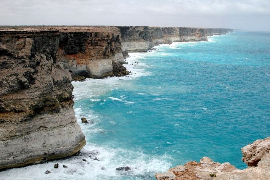 Perhaps each Australian would gain from pilgrimage to the infinite horizon of The Great Australian Bight,
to grasp its awe and so with it, their own smallness.
[Ed: Note the curvature of the horizon. The planet is not as unlimited as many babyboomers imagine.] Perhaps each Australian would gain from pilgrimage to the infinite horizon of The Great Australian Bight,
to grasp its awe and so with it, their own smallness.
[Ed: Note the curvature of the horizon. The planet is not as unlimited as many babyboomers imagine.]
.
To the European man Australia as firstly a mere conception, a conjecture on the earliest world maps, the Great South Land. With exploration and discovery the land grew in the minds of explorers, the map makers and the ruling classes of Europe. To Asian man Australia was a reality, particularly its northern shores which were frequently visited by peoples of the islands to the north. To the Aborigines Australia was home and has been for at least 40,000 years.
Europeans, being the latest of mankind’s races to make contact with Australia are, due to their history and traditions, the least capable of understanding the land. Having only settled here for seven or eight generations many European types have yet to establish a connection with the land beyond that of viewing the land as a resource. The last two hundred (and twenty five) years has seen the land undergo significant changes, the changes of occupation. No longer is the land in a state of balance but a state of change based on economic development.
.
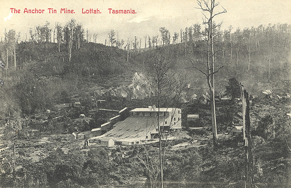 Anchor Tin Mine , Lottah Tasmania
(Tasmaniana Library, State Library of Tasmania) Anchor Tin Mine , Lottah Tasmania
(Tasmaniana Library, State Library of Tasmania)
.
As this development gained momentum during the twentieth century the new arrivals became less dependent on the land for their existence. There was a shift of values regarding the land; values which alienated the land further from the occupiers. European man did not see the land as nurturer but as a resource to be exploited. >>
.
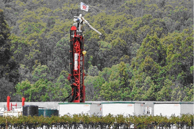 Coal Seam Gas Mining in the Hunter Valley north of Sydney, 2012
^http://www.huntervalleyprotectionalliance.com/HVPA_brochure_20120109.html Coal Seam Gas Mining in the Hunter Valley north of Sydney, 2012
^http://www.huntervalleyprotectionalliance.com/HVPA_brochure_20120109.html
.
<<..The history of European occupation of the lands of Australia is not a good one. Through fear, ignorance, greed or power much of the land has suffered. It is thought that the earliest settlers wanted to create landscape similar to where they came from so they imported planst and animals and a way of life in order to tame what they thought was a harsh environment.
.
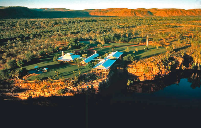 El Questro Station, The Kimberleys
Some things don’t change. The cattle station was initially established in 1903.
In 1991, an English aristocrat bought the cattle station and developed into a tourist park, and continues to run 8,000 head of cattle.
[Source: ^http://www.broomeandthekimberley.com.au/gibb-river-road-and-gorges/] El Questro Station, The Kimberleys
Some things don’t change. The cattle station was initially established in 1903.
In 1991, an English aristocrat bought the cattle station and developed into a tourist park, and continues to run 8,000 head of cattle.
[Source: ^http://www.broomeandthekimberley.com.au/gibb-river-road-and-gorges/]
.
The discovery of gold brought (considerably) more people who came to exploit the land without returning anything to it; needless to say many remained on the goldfields though most returned to coastal cities or to whence they came. Then followed a period of pastoral expansion whereby over ten per cent of the land was cleared of trees and another sixty per cent was grazed, browsed and trampled by sheep and cattle. Even today vast tracts of country are being cleared of vegetation.
.
 Queensland Premier Campbell Newman’s government this week passed the Vegetation Management Framework Amendment Bill, which effectively removes protection of two million hectares of mature and recovering bushland.
[Source: ‘Newman takes axe to Abbott’s Direct Action, and Qld bush’, 20130524, by Giles Parkinson, Australian and New Guinea Fishes Association – QLD Inc. ^http://www.angfaqld.org.au/aqp/blog/2013/05/24/newman-takes-axe-to-abbotts-direct-action-and-qld-bush/] Queensland Premier Campbell Newman’s government this week passed the Vegetation Management Framework Amendment Bill, which effectively removes protection of two million hectares of mature and recovering bushland.
[Source: ‘Newman takes axe to Abbott’s Direct Action, and Qld bush’, 20130524, by Giles Parkinson, Australian and New Guinea Fishes Association – QLD Inc. ^http://www.angfaqld.org.au/aqp/blog/2013/05/24/newman-takes-axe-to-abbotts-direct-action-and-qld-bush/]
.
Much of the Brigalow country of Queensland is disappearing; plans have been put forward to clear parts of the Western Division of New South Wales for crops while the conservative elements in Western Australia had plans to clear the Yilgarn and Dundas wilderness so that the sons of farmers could work their own properties. All this was (and is?) to occur in the face of unreliable rainfall, rising salt in the soil (which makes the land useless in less than three generations), and a loss of countless habitats.
.
 Brigalow Ecological Community (Acacia harpophylla) Brigalow Ecological Community (Acacia harpophylla)
Listed as Endangered in 2001 due to two centuries of continuing mass deforestation for cropping and pasture.
^http://www.environment.gov.au/cgi-bin/sprat/public/publicshowcommunity.pl?id=28&status=Endangered
.
Though fear of the land may have been reduced over the last two hundred (and twenty five) years ignorance, greed or power are still potent masters, and each still operates to alienate the European from his or her new landscapes.
The landscape does not evoke fear or alienation, the mind does. The landscape can trigger those feelings but it is the perception of that landscape through ignorance or a lack of understanding that induces a negative reaction.
Changing one’s perception requires more than changing one’s mind but it may be that understanding and interpreting what is being seen is all that is required. Interpretation need not be involved because all it requires is a knowledge of its components. It’s how these components fit together that is complicated. To be able to put a name to something greatly assists in interpreting what is being seen while to actually discover that named ‘something’ is an experience in itself. >>
.
~ Extracts from the Introduction, in The Bush – a Guide to the Vegetated Landscapes of Australia, by Ian G. Read, 1987, Reed Books, pp. 9-10.
.
Perceived character of natural areas (1978):
.
<<
- Less than 4% see natural areas as bad, ugly, noisy, dirty, repulsive, evil, wasteful, boring, dead, uninviting, dull, useless or depressing
- Between 4% and 25% see natural areas as bleak, dangerous or fragile
- Between 25% and 50% see natural areas as happy, friendly, sacred, huge, roadless or pure
- More than 50% see natural areas as good, remote, alive, exciting, unique, wild, challenging, inspiring, valuable, restful, unspoiled, free, beautiful or natural. >>
.
~ Based upon research for a doctoral thesis by Keith McKenry, contained in Mosley, 1978.
.
“Too far South for spices and too close to the rim of the earth to be inhabited by anything but freaks and monsters.”
.
~ Abel Tasman upon sighting the West Coast of Tasmania in November 1642.
.
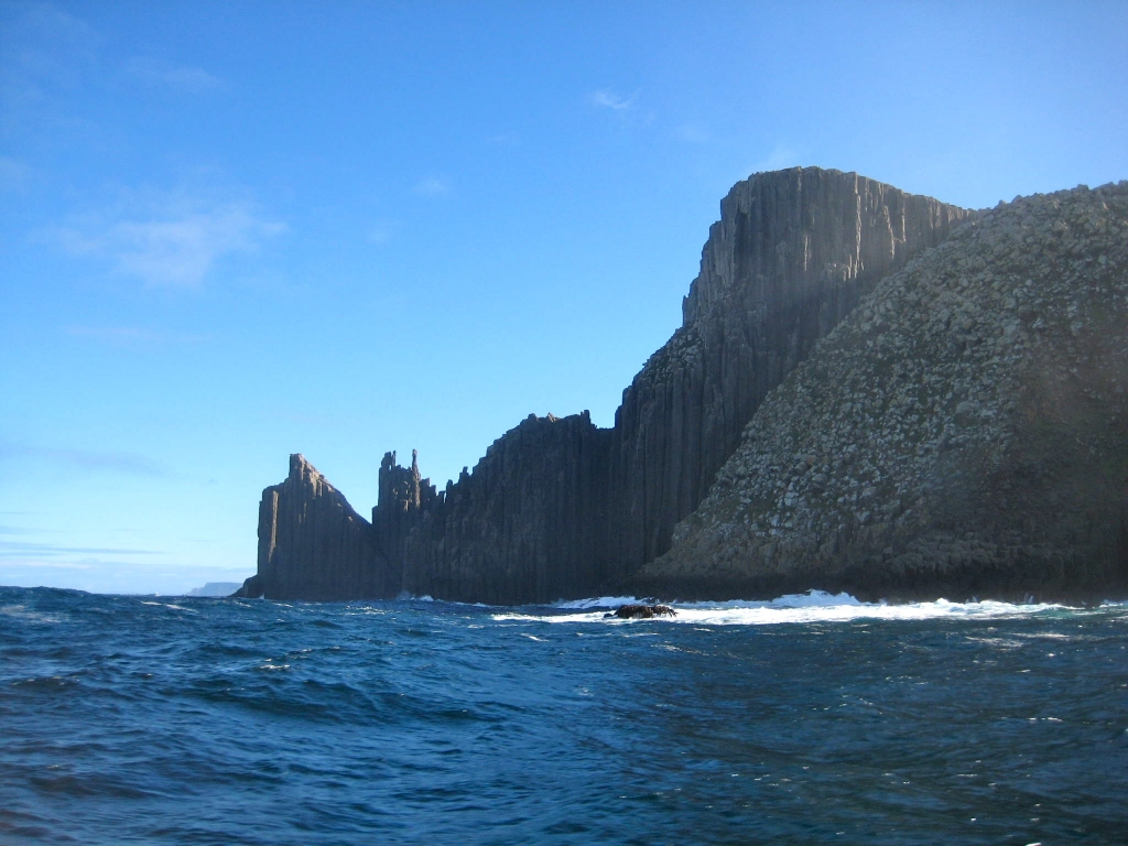 Photograph of Cape Point Raoul, South West Wilderness, Tasmania.
[Source: Jane Stadler, ^http://www.australian-cultural-atlas.info/CAA/listing.php?id=72] Photograph of Cape Point Raoul, South West Wilderness, Tasmania.
[Source: Jane Stadler, ^http://www.australian-cultural-atlas.info/CAA/listing.php?id=72]
.
<< Australia’s most important environmental case, ‘the Franklin Dams Case’, a successful High Court challenge, influenced the outcome of a federal election and resulted in World Heritage nomination for south-west Tasmania in 1982.
Enlarged in 1989 to cover 20 per cent of Tasmania’s land area, the Tasmanian Wilderness World Heritage Area (1.38 million hectares) failed to protect the tall eucalypt forests excluded by a convoluted eastern boundary. These ancient forests are being progressively decimated by industrial forestry, despite an international outcry. The south-west is recognised as one of the earth’s few remaining extensive temperate wilderness areas, a significant tourist drawcard posing fresh challenges as increasing visitor numbers impact on its outstanding natural values. >>
..
[Source: South West, by Helen Gee, 2006, in Companion to Tasmanian History, Centre for Tasmanian Historical Studies, University of Tasmania,^http://www.utas.edu.au/library/companion_to_tasmanian_history/S/South%20west.htm]
.
<< Overall, Australia has lost nearly 40% of its forests, but much of the remaining native vegetation is highly fragmented. As European colonists expanded in the late 18th and the early 19th centuries, deforestation occurred mainly on the most fertile soils nearest to the coast.
In the 1950s, south-western Western Australia was largely cleared for wheat production, subsequently leading to its designation as a Global Biodiversity Hotspot given its high number of endemic plant species and rapid clearing rates. Since the 1970s, the greatest rates of forest clearance have been in south-eastern Queensland and northern New South Wales, although Victoria is the most cleared state.
Today, degradation is occurring in the largely forested tropical north due to rapidly expanding invasive weed species and altered fire regimes. Without clear policies to regenerate degraded forests and protect existing tracts at a massive scale, Australia stands to lose a large proportion of its remaining endemic biodiversity. The most important implications of the degree to which Australian forests have disappeared or been degraded are that management must emphasize the maintenance of existing primary forest patches, as well as focus on the regeneration of matrix areas between fragments to increase native habitat area, connectivity and ecosystem functions. >>
.
[Source: ‘Little left to lose: deforestation and forest degradation in Australia since European colonization’, by Corey J. A. Bradshaw, School of Earth and Environmental Sciences, The University of Adelaide, article in Journal of Plant Ecology, Vol. 5, Issue 1, pp. 109-120, ^http://jpe.oxfordjournals.org/content/5/1/109.full]
.
.
.
Further Reading:
.
[1] ‘A Terrible Beauty‘, by Richard Flanagan, , Melbourne, 1985, Greenhouse Publications
.
[2] ‘The South West Book’, by Helen Gee & Janet Fenton,1978, Melbourne, William Collins and the Australian Conservation Foundation
.
[3] ‘Trampled Wilderness’, by R & K Gowlland, Devonport, 1975, C.L. Richmond and Sons Pty Ltd
.
[4] ‘History of West and South-West Tasmania’, by T Jetson & R Ely, Hobart, 1995, Tasmanian Historical Research Association
.
[5] ‘Patriots: Defending Australia’s Natural Heritage‘, by William J. Lines, 2006, University of Queensland Press
.
[6] ‘The Biggest Estate on Earth: How Aborigines Made Australia‘, by Bill Gammage, 2012, Allen & Unwin
.
[7] ‘Woodland to Weeds – Southern Queensland Brigalow Belt‘, by Nita C. Lester, 2008, 2 ed, Brisbane: Copyright Publishing
.
[8] ‘ The Discovery of Tasmania: Journal Extracts from the Expeditions of Abel Janszoon Tasman and Marc-Joseph Marion Dufresne, 1642 & 1772‘, rare book by Abel Tasman.
.
Wednesday, October 2nd, 2013
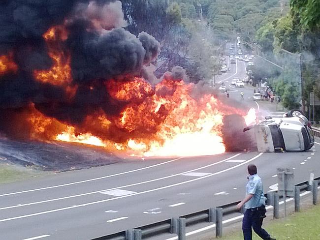
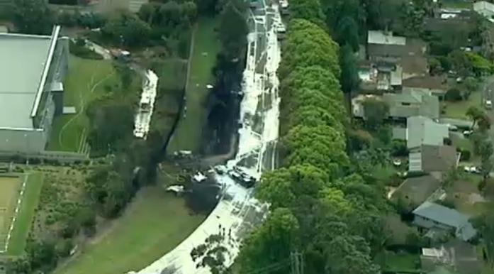
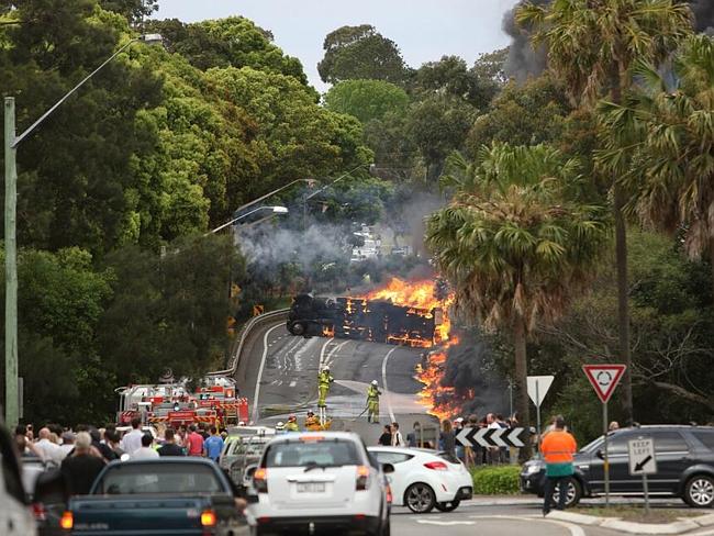 An out of control petrol tanker semi-trailer speeding 80kph down Mona Vale Road rolls and explodes, burning two motorists to death. An out of control petrol tanker semi-trailer speeding 80kph down Mona Vale Road rolls and explodes, burning two motorists to death.
A further six people remain in hospital. The truck was carrying 18,000 litres of fuel when it rolled and erupted into a fireball. Mona Vale in is Sydney’s north.
[Source: The Daily Telegraph, 20131001, ^http://www.adelaidenow.com.au/news/driver-a-8216hero8217-after-runaway-tanker-explodes-in-mona-vale-victims-never-had-a-hope-witnesses-say/story-e6frea6u-1226730998888]
.
The cause is unknown at this stage, but it is the consequence that is the issue, irrespective.
Hardly a day goes past without some news story about a truck crash on a Sydney road and this is compounded across Australia.
Yet in transport policy unison, governments across Australia at state and federal levels have abandoned rail freight and instead are headlong encouraging more and bigger trucks on our roads. They are encouraging larger and long trucks and spending billions to accommodate them. Road making has become governments’ panacea for solving linehaul freight challenges. The numbers of trucks on local, suburban and regional roads across Australia must have doubled in the past decade or so.
At the same time, both levels of government have been lax for decades to ensure high standards of heavy vehicles and the professional competency of truck drivers. Australian trucking has become a cowboy game plagued by industry cost cutting and unreasonable delivery expectations. The industry’s problems compound down to the truckie.
Truck drivers across Australia are no longer paid a fair hourly rate for their work, but have been reduced to being paid by a minimalist ‘trip rate’. So the more trips they do, the more they get paid. Overnight linehaul trucking is a ticking time bomb.
Truck drivers across Australia more often than not are no longer paid employees who are professionally trained by their employers. They are typically owner driver sub contractors with a massive bank mortgage tied to the truck or prime mover they own. They only get paid by the runs they do and have all the burden of maintenance, repairs, insurance and loan repayments. That is before paying themselves a wage. Forget leave and superannuation.
Trucking industry professionalism is out the door. Anyone can get a truck licence. The concept of trucking being a profession in Australia in the days of TNT and Mayne Nickless has long become a distant memory. It is a mugs game now.
Truck drivers, motorists and roadside communities are the victims of dumbed down bad government transport policy. The only ones who are benefiting from cheap dumbed down trucking are the trucking magnates and their corporate retail clients. The politicians save money building trucking roads instead of big picture rail and integrated multimodal logistics. But roads for trucks is short term thinking. It is a policy that has ignored road users’ rights to expect the highest standards of road safety.
Australia’s trucking regime is sapping billions for faster and wider roads instead of long term investment in freight rail,just like their doing to the Great Western Highway to freight produce and goods across the continent. It’s to hell with the local communities they rip up along the way. It’s to hell with the native habitat they rip up to build wider and new trucking expressways. When fuel and toxic chemicals spill from overturned trucks, it’s to hell with the downstream environment.
More roadside communities are increasing exposed to the risk of deadly speeding trucks, and people are dying as a result.
.
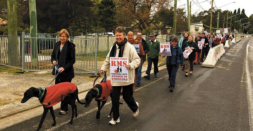 Safety First
Residents of the roadside community of Woodford in the Blue Mountains west of Sydney protest over losing their pedestrian crossing so that trucks can cruise nudging 90kph through their village. [Photo by Jodi McConaghy, 20130608] Safety First
Residents of the roadside community of Woodford in the Blue Mountains west of Sydney protest over losing their pedestrian crossing so that trucks can cruise nudging 90kph through their village. [Photo by Jodi McConaghy, 20130608]
.
The NSW Government’s RTA-come-RMS (roads authority) has “ripped the heart” out of Woodford.
Woodford Progress Association spokesman Ian Robinson told 100 residents in a protest rally last June that Woodford was “once known as the heart of the Mountains but the RMS has ripped the heart right out of our town”. Mr Robinson says the current plans leaves the elderly stranded, splits the town in two and forces school children to make a large detour to get to their bus stop, he said.
“Without lights across the highway within the vicinity of the Woodford Academy, not only children, but also residents and fire brigade volunteers on the north side are cut off from south side neighbours [and] the elderly … are stranded in their own village,” he said.
The truck-centric civil engineers with the RTA-come-RMS expect local residents to take a two kilometre detour to use the pedestrian bridge at Woodford railway station.
Mr Robinson said:
“They also now tell us that they do not regard Woodford as a ‘town’ and that they want to run four lanes of traffic at 80 km/hr right through the heart of Woodford.”
Cheap but dangerous seagull intersections are to be built in the centre of the new wider trucking expressway between massive trucks doing 90kph down the hill through Woodford.
A third resident petition to the NSW Roads Minister has again been ignored. It’s all about trucks with the politicians.
(Former) councillor Geordie Williamson, a Woodford resident, says the plan also threatens the lives of the 2500 Woodford residents.
“The very least RMS can do is grant residents a safe means of crossing the newly-widened highway. Failing to do so will virtually guarantee injury or loss of life in the years to come,” Clr Williamson said. “The highway should not only be designed to massage the bottom line of freight haulage companies.”
[Source: ‘Woodford fights for safer passage’, 20130620, by B. C Lewis, Blue Mountaisn Gazette, ^http://www.bluemountainsgazette.com.au/story/1585708/woodford-fights-for-safer-passage/]
.
 The Mona Vale Road trucking experience
Coming to a roadside community near you. The Mona Vale Road trucking experience
Coming to a roadside community near you.
.
Footnote
.
Government belatedly issues Cootes Transport with 126 Defect Notices
.
 . .
<< Police believe mechanical problems are the most likely cause of the fatal crash involving the Cootes Transport petrol tanker since the out-of-control fuel tanker ploughed into a power pole and four cars before erupting in a fireball on Mona Vale Road.
A Mr Shane Day has been identified as the driver of the petrol tanker, who works for Cootes Transport. It is not clear if he is an employee or a contractor, but industry probability would like be the latter and not paid by Cootes by the hour.
So two men were burnt alive when this Cootes petrol tanker lost control on Mona Vale Road at Mona Vale about 3:40pm (AEST) yesterday. Police say the dead men are a 71-year-old local and a man in his 60s from interstate. Both men were travelling in the same car, when this trucking wall of death bore down upon them.
Assistant Police Commissioner John Hartley:
“It certainly looks like they were killed at the scene by the fire rather than the crash itself.”
They were burnt alive.
Twelve trucks operated by Cootes Transport have been taken off the road. Inspectors from the New South Wales Government’s Roads and Maritime Services have subsequently inspected more than 80 Cootes Transport trucks at checking stations in Sydney and Newcastle late this afternoon. The company has been issued with 26 defect notices and 12 trucks have been taken off the road.
[Ed: A belated slap on the wrist for purported negligence causing two men to burn to death, just to pacify the media and political fallout. Government reactive and random monitoring of safety is negligent cost cutting and so life costing. At no time should unroadworthy trucks be in service. At no time should unprofessional heavy vehicle drivers be behind the wheel. It must cost more, and so be it. Next week as the media interest fades, it’ll be government trucking as usual and billion dollar truck magnate profit as usual].
.
Mr Hartley:
“We’re investigating a number of factors that may have contributed to the crash but at this stage we’re looking at the possibility of mechanical failure on the truck itself. That’s probably the most important lead we have at this stage. The vehicle needs to be fully examined properly. At the end of the day we’ll find that something quite simple such as mechanical failure or a mistake by the driver has caused these fatal consequences.”
.
Meanwhile, the toxic spill caused by a fuel tanker’s 18,000 litres of petrol from the exploded tanker has flooded and contaminated surrounding waterways and bushland.
A mix of fuel and fire retardant has leaked into the surrounding waterways for at least a 1.5 kilometre radius.
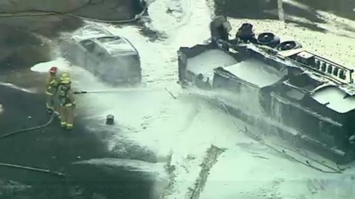 A toxic mix of 18,000 litres of petrol and fire retardant polluting surrounding waterways.
Without trucks Australia may stop, but with the current trucking mentality people are dying, like the two men burnt to death in the above car.
(Source: ABC News) A toxic mix of 18,000 litres of petrol and fire retardant polluting surrounding waterways.
Without trucks Australia may stop, but with the current trucking mentality people are dying, like the two men burnt to death in the above car.
(Source: ABC News)
.
NSW Fire Brigade Superintendent Ian Krimmer:
“It is a big operation to clean up the leaking fuel which has seeped into drains and waterways at Mona Vale. We’re placing sand in a number of those drains to contain the fuel spillage,” he said. It’s still unknown how much fuel has leaked into those drains. It could take several days to mop up and clean up that particular situation.”
.
 With Trucks Australia Stops With Trucks Australia Stops
.
[Sources: ‘Cootes trucks taken off the road after fatal tanker explosion in Mona Vale’, 20131002, ^http://www.abc.net.au/news/2013-10-02/mechanical-failure-suspected-cause-of-tanker-explosion/4994502; ‘Truck driver’s name revealed’, 20131004, ^http://www.dailyadvertiser.com.au/story/1819612/truck-drivers-name-revealed/?cs=332; ‘Toxic spill clean-up continues after fatal tanker crash at Mona Vale in Sydney’s north’, 20131002, ^http://www.abc.net.au/news/2013-10-01/two-dead-in-fuel-tanker-crash-in-sydney27s-north/4991974]
.
Tags: fuel and toxic chemicals, Great Western Highway, Mona Vale Road, overnight linehaul trucking, Petrol Tanker Crash, professional trucking, Roads and Maritime Services, RTA, RTA-come-RMS, speeding semi trailer, truck spills, trucking expressway, With Trucks Australia Stops, Without Trucks Australia Stops, Woodford pedestrian lights
Posted in Threats from Road Making | No Comments »
Add this post to Del.icio.us - Digg
Monday, September 30th, 2013
 Hawkesbury Heights hazard reduction negligence
Well our fire “escaped”. Sorry, we’re immune from prosecution. Hawkesbury Heights hazard reduction negligence
Well our fire “escaped”. Sorry, we’re immune from prosecution.
[Photo by our Investigator along Hawkesbury Road, Blue Mountains, Australia, 20130921, photo © under ^Creative Commons]
.
Partners in crime: big ego Blue Mountains National Parks with even bigger ego Blue Mountains RFS, have jointly stuffed up big this time.
.
 A hazard reduction north of the Hawkesbury Road from the previous weekend was left abandoned.
A few days later the forecast wind picked up and voila: HR come wildfire. Woops.
Sound familiar? Warrumbungles (2013), Macleay River (2012), Grose Valley (2006), Canberra Firestorm (2003) A hazard reduction north of the Hawkesbury Road from the previous weekend was left abandoned.
A few days later the forecast wind picked up and voila: HR come wildfire. Woops.
Sound familiar? Warrumbungles (2013), Macleay River (2012), Grose Valley (2006), Canberra Firestorm (2003)
[Source: Fairfax, ^http://www.smh.com.au/nsw/hazard-reduction-burn-started-major-sydney-bushfire-20130913-2tois.html]
.
Hawkesbury Heights residents will recall last year’s escaped hazard reduction along the Springwood Ridge inside the Blue Mountains National Park. It was left for few days, then the forecast prevailing sou’wester picked up on 30th August 2012. The fire jumped containment lines then threatened the Bowen Mountain community to the nor’ east.
<<More than 30 firefighters from the NSW Rural Fire Service and National Parks and Wildlife Service have worked behind homes in the community of Bowen Mountain to contain this fire. Crews backburned to establish containment lines around the fire with the assistance of helicopters and earth moving machinery.>>
 National Park ablaze thanks to government-sanctioned arson National Park ablaze thanks to government-sanctioned arson
[Source: Blue Mountains RFS, ^ http://www.bluemountains.rfs.nsw.gov.au/dsp_more_info_latest.cfm?CON_ID=18199, Reference will probably disappear within days of publication.]
How much did that stuff up cost? This is where donations to the RFS are going.
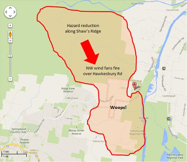
The Habitat Advocate reconstructs that the HR folly at Hawkesbury Heights two weeks ago probably unfolded as follows:
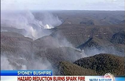
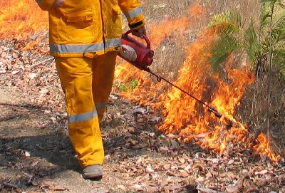
Blue Mountains National Parks decides that its a good idea to set fire to the Blue Mountains National Park along Shaws Ridge. Shaws Ridge is over two kilometres from the Hawkesbury Road. It has nothing to do with ‘asset protection’ to private properties. So the Parks Service just calls it ‘strategic’ or an ‘ecological burn’ – good for the bush.
“Generally over an 8-12 year cycle it [vegetation] needs to be burnt, which allows it to regenerate.” ~ Blue Mountains RFS district manager David Jones, 20130918.
The bush and its wildlife likes being burnt. Parks Service’s gospel Fire Maps shows in bright red that this part of the protected Blue Mountains National Park (World Heritage Area) hasn’t been burnt for 8 years, so it must to be burned, just in case it burns!
So the fire cult’s mindset is fixated. Parks Service includes the area to its annual hazard reduction burning programme and checks the weather forecast. The Bureau of Meteorology forecasts low winds but with expected changes later in the week. She’ll be right. The job will be over in a day. Parks Service sees the low wind HR window and goes for it.
Parks Service musters up their fire friendly mates at the RFS down at Winmalee and Hawkesbury Heights and complicitous stations. The HR is on! So all the cracks had gathered to the fray. All the tried and noted firies from the stations near and far mustered along Shaws Ridge fire trails. For the firies love the smell of wood smoke along the fire trails and the old red Isuzu’s snuff the battle with delight.
 Hazard Reduction: Reducing the World Heritage Hazard
‘Cos see when there’s a real wildfire, Dad’s Army can’t cut the mustard Hazard Reduction: Reducing the World Heritage Hazard
‘Cos see when there’s a real wildfire, Dad’s Army can’t cut the mustard
.
The hazard reduction proceeds on the Sunday 8th September with hardly a breeze in hilly timbered terrain, using trucks only along ‘fire’ trails. We won’t need choppers. They’ll only blow the budget. Sunday night falls, job done and the vols go home. Monday a bit windy, then Tuesday really warm and the wind picks up, gusty to blazes.
The media reports as follows:
<<A hazard-reduction burn that got out of control sparked one of four major bushfires that ravaged western Sydney and the Blue Mountains this week, fire authorities have revealed.
NSW Rural Fire Service Deputy Commissioner Rob Rogers said the National Parks and Wildlife Service had been conducting a hazard-reduction burn near Hawkesbury Road in Winmalee last weekend, which flared up in Tuesday’s soaring temperatures and high winds. [Ed: Winmalee? Close, but try Hawkesbury Heights further north.]
Rob Rogers:
“Basically it was burnt on the weekend, it was patrolled on Monday, there was smouldering activity. That fire then jumped containment lines [on Tuesday].”
.

.
 The Parks Service and RFS secretively keep fire operational matters behind closed doors for fear of embarrassment and of being sued.
So our research investigator conducted a post-fire inspection on Saturday 20130921 and has estimated the above impact and scenario.
Perhaps those in charge can prove us wrong? We invited them to.
[Source: The Habitat Advocate, assisted with Google Maps] The Parks Service and RFS secretively keep fire operational matters behind closed doors for fear of embarrassment and of being sued.
So our research investigator conducted a post-fire inspection on Saturday 20130921 and has estimated the above impact and scenario.
Perhaps those in charge can prove us wrong? We invited them to.
[Source: The Habitat Advocate, assisted with Google Maps]
.
<<Just 10 minutes earlier the family had been told by firefighters to remain calm before a freak wind change sent the blaze roaring uphill towards their house. “Evacuate” was the order.>>
[Source: ‘I put my foot down and drove through the fire’: Mother tells how she fled with children in Winmalee’, 20130911, by Taylor Auerbach, The Daily Telegraph, ^http://www.dailytelegraph.com.au/news/nsw/i-put-my-foot-down-and-drove-through-the-fire8217-mother-tells-how-she-fled-with-children-in-winmalee/story-fni0cx12-1226716604185]
.
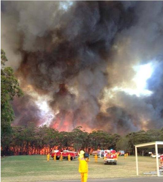
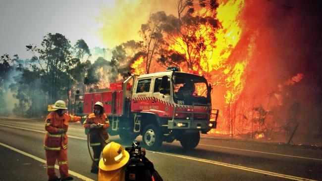 Tackling the Winmalee Hazard Reduction come Wildfire on Hawkesbury Road.
Heroes extinguishing the neglect of their Parks Service cousins. Tackling the Winmalee Hazard Reduction come Wildfire on Hawkesbury Road.
Heroes extinguishing the neglect of their Parks Service cousins.
.
<<A fire burning in the area of Hawkesbury Road at Winmalee has already claimed one property, with more than 100 firefighters working to contain the blaze. Five firefighters have suffered from smoke inhalation and two received minor burns battling the fire in Winmalee.>>
[Source: ‘Bushfire burns Winmalee home, others at risk in Blue Mountains’, 20130910, Sydney Morning Herald, Photo by Nick Moir, ^http://www.smh.com.au/nsw/bushfire-burns-winmalee-home-others-at-risk-in-blue-mountains-20130910-2ths1.html]
.
<< Firefighters have contained a blaze that has burnt through more than 1000 hectares of bushland west of Sydney. The fire, at Winmalee in the Blue Mountains, has been burning since Tuesday fanned by high temperatures and strong winds, plunging the region into emergency. Firefighters were still water bombing the burning bushland on Thursday.
The Rural Fire Service on Friday said the fire had been contained.
RFS spokeswoman Laura Ryan:
“It was brought fully under control last night just before a community meeting at Winmalee High School. Firefighters (unpaid) would today work to extinguish the blaze, but said it was too early to say how long that would take. Firefighters will be working hard to get every bit of that fire out.”
The RFS and NSW Police say they have launched investigations into the cause of the bushfire, with some locals raising concerns that recent hazard reduction burns in the area may be responsible. [Ed: NSW Police need not investigate far beyond the operational records of the Blue Mountains National Parks and Wildlife Service, with internal documents circulated to the RFS]
.
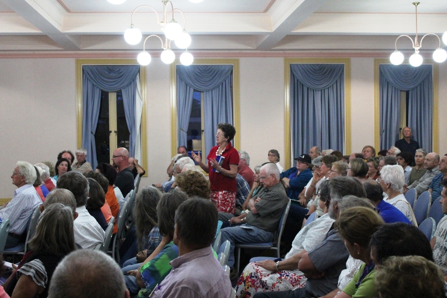
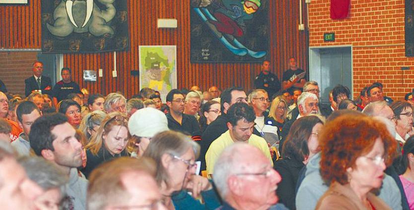 More than 350 Blue Mountains residents pack the Winmalee High School on Thursday night 12th September, fearful whether they could lose their homes to Hazard Reduction.
[Source: ^http://news.ninemsn.com.au/national/2013/09/13/07/00/winmalee-bushfire-contained-rfs]
More than 350 Blue Mountains residents pack the Winmalee High School on Thursday night 12th September, fearful whether they could lose their homes to Hazard Reduction.
[Source: ^http://news.ninemsn.com.au/national/2013/09/13/07/00/winmalee-bushfire-contained-rfs]
.
<< A Rural Fire Service organised community meeting held last week at Winmalee to discuss the fire situation in Winmalee and Yellow Rock was well attended.
Winmalee and Yellow Rock residents aired their bushfire concerns at a community meeting organised by the NSW Rural Fire Service (RFS) at Winmalee High School last Thursday night.
Despite the meeting only being publicised that day, the school hall was nearly full with 350 residents. At least 10 people in the room did not receive an RFS emergency safety warning text message to take shelter.
Blue Mountains RFS district manager David Jones said he would, “feed that back up the line … it may be a service provider issue, I’m not sure, that may be part of it” and that he would look further into the issue.
A Yellow Rock resident asked what hazard reduction burns would take place in Yellow Rock in the near future.
Supt Jones said the weather conditions last week hadn’t been suitable to maintain control of a backburn.
“It’s a one-way, one-road in and its never received the recognition it deserves on that basis in terms of protection,” the Yellow Rock resident said. “I would hate to see a real emergency situation develop here at Yellow Rock.”
Supt Jones said he’d look at the RFS organising a meeting with Yellow Rock residents in the near future to address these issues. Supt Jones said residents could have a fire mitigation officer assess if hazard reduction was needed in their area by lodging a hazard complaint with the RFS.
“Generally over an 8-12 year cycle it [vegetation] needs to be burnt, which allows it to regenerate,” he said.
National Parks and Wildlife Service (NPWS) Upper Mountains area manager Richard Kingswood said there weren’t many days a year suitable for conducting hazard reduction burns — only 10 days in the Upper Mountains and a few more in the Lower Mountains, although last autumn and spring had provided more opportunities. He said in the last financial year NPWS had initiated 38 burning operations over 50,000 hectares, which was more than usually occurred.
Another resident asked why, with safety concerns with overhead powerlines, they couldn’t go underground, especially as the highway was being widened. An Endeavour Energy spokesman said cost was an issue. “It costs about 10 times more to put mains underground.”
Others were concerned about issues around road blocks, where children as well as adults were allowed to walk past roadblocks to return home, yet people couldn’t get their vehicles through. It didn’t make sense from a safety perspective, the resident said.>>
[Source: ‘Concerns aired at Winmalee fire meeting’, 20130918, by Ilsa Cunningham, Blue Mountains Gazette, ^http://www.bluemountainsgazette.com.au/story/1782194/concerns-aired-at-winmalee-fire-meeting/]
.
 Hawkesbury Road well and truly hazard reduced
[Photo by our Investigator along Hawkesbury Road, Blue Mountains, Australia, 20130921, photo © under ^Creative Commons] Hawkesbury Road well and truly hazard reduced
[Photo by our Investigator along Hawkesbury Road, Blue Mountains, Australia, 20130921, photo © under ^Creative Commons]
.
<< More than 1200 firefighters were involved in battling the four major fires on Tuesday along Hawkesbury Road in Winmalee; in Marsden Park in the Blacktown area; near Tickner Road in Castlereagh; and Richmond Road at Windsor. Fourteen helicopters and 350 trucks from the Rural Fire Service, Fire and Rescue NSW and the National Parks and Wildlife Service were involved in the firefight.
Just before 1.30pm on Tuesday, the temperature in Sydney was 31.6 degrees. Mr Rogers said strong wind also made fire conditions worse, with gusts reaching 90 kilometres an hour, which was much higher than forecast.
He said RFS firefighters helped in the hazard-reduction operation in Winmalee, which was under the supervision of the NPWS, and he apologised to anyone who experienced property damage.
“Combined with the winds, how dry it is, the temperature and the steep terrain, fire takes hold very, very quickly.”
He said the RFS also was investigating whether a hazard-reduction burn escaped and forced the closure of the M1 (formerly the F3) Motorway on Thursday.
“You would have to obviously be suspicious that it did come from a hazard-reduction, given that it was in a very close proximity to it. That’s something that we’re going to be looking at very, very closely,” he said.>>
<<Fire authorities have issued an emergency warning for a bushfire threatening homes in Castlereagh in Sydney’s west, and alerts for other out of control bushfires in Blacktown and Hawkesbury.
NSW Rural Fire Service Deputy Commissioner Rob Rogers said National Parks and Wildlife Service had been conducting a hazard reduction burn near Hawkesbury Road in Winmalee last weekend. The fire flared with Tuesday’s soaring temperatures and high winds.
..He apologised to anyone who experienced property damage from the Winmalee fire. ”..It appears on first look that it’s a case of the weather was worse than was predicted, the fire jumped out, it took hold really..quickly.” >>
Even though the fire ripped through Hawkesbury Heights, the National Parks and Wildlife Services has released a public notice asking any Winmalee residents who experienced property damage or loss have been urged to contact NPWS on 1300 361 967 for sympathy and counselling.
New South Wales Rural Fire Service (paid) Deputy Commissioner Rob Rogers has said that his (unpaid) RFS firefighters helped in the hazard-reduction operation in Winmalee, which was under the supervision of the NPWS, and he apologised to anyone who experienced property damage.
.
 RFS: Sorry about that
Property loss at Hawkesbury Heights (Wheatley Road?) but who pays?
Owner: “we won’t need hazard reduction for a while.”
[Source: ‘Bushfire wake-up call’, 20130918, by Shane Desiatnik,
^http://www.theleader.com.au/story/1782048/bushfire-wake-up-call/] RFS: Sorry about that
Property loss at Hawkesbury Heights (Wheatley Road?) but who pays?
Owner: “we won’t need hazard reduction for a while.”
[Source: ‘Bushfire wake-up call’, 20130918, by Shane Desiatnik,
^http://www.theleader.com.au/story/1782048/bushfire-wake-up-call/]
.
[Sources: ‘Hazard reduction burn started major Sydney bushfire’, by Megan Levy, 20130913, ^http://www.smh.com.au/nsw/hazard-reduction-burn-started-major-sydney-bushfire-20130913-2tois.html; and ‘Burn-offs and arson suspected as cause of two bushfires’, by Megan Levy and Peter Hannam, 20130914, ^http://www.smh.com.au/nsw/burnoffs-and-arson-suspected-as-cause-of-two-bushfires-20130913-2tq15.html]
.
National Parks and Wildlife Advisory Council Report
(42nd meeting held on 28-29 May 2013)
.
<< Council noted the following details regarding the current status of fire management activity by NPWS:
- The 135 000ha annual target has been met with a total of 176 000ha now treated.
- Almost 3 times more area treated than the average for last five years.
- 6-7000ha hazard reduction activity planned over the next week.
- Opportunity to increase positive community profile for NPWS.
- Statewide strategy with performance indicators in place at state and regional levels. >>
.
[Source: New South Wales Government, NSW National Parks and Wildlife Service, ^http://www.environment.nsw.gov.au/resources/about/NPWAdvisoryCouncMay2013.pdf]
.
 In Parks we Trust In Parks we Trust
.
In New South Wales the National Parks and Wildlife Act became law on 1 October 1967. The legislation created a single agency, the National Parks and Wildlife Service, to care for, control and manage the original nineteen parks and any new ones created in the future.
.
.
.
Further Reading:
.
[1] ‘NPWS Fire Fighters Recognised for Service as NSW Gets 10 Year Fire Plan‘, 20130422, NSW Government, ^http://www.environment.nsw.gov.au/resources/MinMedia/MinMedia13042201.pdf
.
[2] ‘National Parks and Wildlife Advisory Council Report‘, 42nd meeting held 20130528-29, NSW Government, ^http://www.environment.nsw.gov.au/resources/about/NPWAdvisoryCouncMay2013.pdf
.
[3] ‘Fire Management Manual, 2012-2013‘, NSW National Parks and Wildlife Service, NSW Government, ^http://www.environment.nsw.gov.au/resources/firemanagement/final/OEH20120645FireMgmtManual.pdf
.
[4] ‘Blue Mountains National Park Plan of Management‘, May 2001, NSW National Parks and Wildlife Service, ^http://www.environment.nsw.gov.au/resources/parks/pomfinalbluemountains.pdf
.
[5] ‘Greater Blue Mountains World Heritage Area – Strategic Plan‘, January 2009, Department of Environment and Climate Change (NSW) with funds supplied by the Australian Government, ^http://www.environment.nsw.gov.au/resources/parks/StategicPlanNPWS.pdf
.
[6] ‘National parks and forest conservation‘, 2006, by Brett J. Stubbs, School of Environmental Science and Management, Southern Cross University, Lismore, New South Wales ^http://fennerschool-associated.anu.edu.au/environhist/links/publications/anzfh/anzfh1stubbs.pdf
.
Tags: Blue Mountains, bush arson, Greater Blue Mountains World Heritage Area, Hawkesbury Heights, Hawkesbury Road, Hawkesbury Road Winmalee Fire, hazard reduction, hazard reduction out of control, National Parks and Wildlife Service, NSW Rural Fire Service, Shaws Ridge, Winmalee Hazard Reduction, Yellow Rock
Posted in Blue Mountains (AU), Threats from Bushfire | 2 Comments »
Add this post to Del.icio.us - Digg
|
|