This article was initially written by Tigerquoll and published on CanDoBetter.net under the title ‘Selfish Murray River Rice Growers downstream continue to castrate the Snowy River‘ on 20100131
.
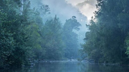
") The Mighty Snowy
The Mighty Snowy
Australia’s High Country
[Source: Adventure Pro, ^http://www.adventurepro.com.au/forums/yabbfiles/Attachments/phpePMK2XAM.jpg]
.
‘What does the Snowy River mean to Australians?
To many ancestral Australians, particularly Eastern Victorians, ‘The Snowy’ is a legendary, wild river.
To the traditional Ngarigo, Walgalu and Southern Ngunnawal people – who asked their opinion, requested their approval?
Would traditional owner’s approval been given? Likely, if open and honest, no bloody way!
The Snowy represents the untamed heart and soul of Australia’s cold frontier High Country
It is a mighty, wild river demanding respect.
But in 1950s Australia, when the colonist Government built its Hydro Scheme, it set out with disrespect to castrate this thundering stallion of a river down to a humiliating prostate trickle.’
~ Ed.

.
Our (stolen) Snowy River, reduced to a trickle
.
 .
.
“Gone are the days
When the Snowy was a river not just a creek.
When the snow water flushed out the entire river.
When the river was deep enough to take large sized boats and ships.
When as a youngster I had picnics on the Curlip paddle-steamer up and down the Snowy River.
When the river bank had several landings to load and unload goods and produce.
When the entrance was deep enough to be safe for all who wished to use it.
The Snowy is just like a ship that has run aground.
Both are no longer able to do what was required of them.
Having lived in Orbost – Marlo all my life
It’s a sad sight to see our Snowy water vanish over the hills to the other side.”
~ bush poem by W. B. Dreverman, born Orbost 12-1-1910.
.PS. I have worked in Orbost all my life; moved from Orbost to Marlo during 1965; now retired; my wife and I enjoy looking at the ocean and the Snowy when the tide comes in. During our lives we have seen the Snowy change from a beautiful river to a sandy bottom creek.
.
 Kosciusko Main Range above the source of the Snowy River
[Source: ^http://forum.weatherzone.com.au/ubbthreads.php/topics/1095133/154]
Kosciusko Main Range above the source of the Snowy River
[Source: ^http://forum.weatherzone.com.au/ubbthreads.php/topics/1095133/154]
.
Account by Charlie Robertson, born in 1919 at Dalgety:
.
“I lived one kilometre from the Snowy River for most of my life.
We could always hear the Snowy singing from home. That is how I used to describe the sound of the river. It used to be quieter in the summer. Now we don’t hear it at all. You wouldn’t know there was a river there now. It was a clear river most of the time, 99 per cent pure. It’s hard water now. Before it was soft.
The river had a gravelly sandy bed with rocks and boulders but they’re overgrown now and you can’t see them. During the spring thaw it used to flow for three months at least in a good strong flow, bank to bank. The level used to be up into the first ring on the pylon for that period.”

…It was a very popular river for fishing. You could see the fish from the bridge. You could just about get to the river anywhere you wanted with some exceptions. Now you can hardly get to it for the weeds, willows and blackberries.
When the river was dammed there was nothing to fish. There was no fish in the dams just after they were built. I have been up there and it doesn’t interest me at all, especially when you’ve spent much of your life fishing the river. It’s a different kind of fishing all together. I used to fish at night for native fish.
They are all gone now. I gave up fishing when they dammed the river. “

The Snowy Mountains Hydro-Electric Scheme is the most complex, multi-purpose, multi-reservoir hydro scheme in the world with 80 kilometres of aqueducts, 140 kilometres of tunnels, 16 large dams and seven power stations, two of which are underground. The project was drievn by then Labor Prime Minister Ben Chifley. It commenced under an Act of Federal Parliament in October 1949 with the goal of diverting the Murrumbidgee, Snowy and Tumut Rivers in south western NSW essentially to provide irrigation water for the western side of the Great Dividing Range, and in the process generate hydro-electric power. This irrigation facilitated settlement of mass immigration.
.
Account by Pip Cogan, born in 1913 at Dalgety and resident 85 years, a grazier:
.
“The Snowy River was part of my life until it was dammed.
I had fished the river since I was a young fellow action against the NSW Government for failing to honour a five-year review of the Snowy Hydro Corporation’s water licence. The Alliance is arguing the legal provisions allowing the Mowamba water flow to be increased without compensationary payments.
It is clear from reading the Snowy Scientific Committee’s three reports so far that the Snowy upper reaches are sick, despite the $425 million agreement in 2002 by three governments to restore it. Sacrificed long ago to humanity’s needs for hydroelectricity and irrigation water for the Murray Darling food bowl, in drought the river has become so deprived of lusty water flow that its cobbles do not turn over. Its deep pools alienate life forms, forbiddingly hot on top and cold on the bottom.
Last month the scientific committee warned the NSW Government that the limited environmental flows allowed from Snowy Hydro dams provide mere ”life support” for plants and animals in the river.”
The continued demise of the magnificent Snowy River is attributed to the political influence of the long downstream self-interested rice growers, cotton growers and citrus and grape growers, all wholly artifically dependent on irrigation from the Murray River, fed by the Snowy River upstream.
But such exploitive irrigation-dependent industries have powerful political friends like the Australian Government Rural Industries Research and Dever the way that it was and it to look at it today is simply heartbreaking.”
 The Snowy River was dry as a bone at Island Bend Dam in February 2010.
(Snowy River Alliance: Louise Crisp)
The Snowy River was dry as a bone at Island Bend Dam in February 2010.
(Snowy River Alliance: Louise Crisp)
.
Account by Kevin Schaefer, born 1925 at Dalgety, resident for 73 years:
.
“The Snowy River was a real river.
In the spring the river flowed very strong after the snow melt. This strong flow existed for many months, usually from August to November. Whilst the spring was characterised by strong flows, the Snowy River could have heavy flows or flooding any time of the year. For example the biggest flood in my lifetime occurred in the summer of 1934.
All the mountain water came down here. The Snowy River’s water was clean and pure.
In fact when you drank it, you couldn’t get enough of it. I can remember the years between 1949 and 1956 as being particularly wet, with a peak in river flow in March 1950 when it flooded. The river could rise and fall all year round depending on the rainfall.
In my lifetime I never saw the river any where near as low as it has been since the damming. …I haven’t seen the platypus like I used to. You could see colonies of platypus along the river before.
Now you’re lucky to see one.”
.
") Talbingo Dam artificially flooded the Snowy River
(‘Tumut 3’ Power Station below)
Talbingo Dam artificially flooded the Snowy River
(‘Tumut 3’ Power Station below)
.
The Snowy River Alliance down here in Victoria is right. Australia’s most famous wild river, the Snowy River, deserves to have its natural flows restored.
The Alliance argues that if the Hydro schemers release just a third of the Snowy’s original flows, its ecology could be restored. But the current life sucking 5% dished out by the Snowy Hydro Ltd corporation is exploitative, selfish and wrong.
The Snowy River Alliance, according to Glenice White of Orbost, deep in Victoria’s East Gippsland, started off back in 1971 as a reaction to the Snowy’s “pronounced signs of degradation“. This local community reaction culminated in the Snowy River Interstate Catchment Co-ordinating Committee Report, which outlined the problems of the river and its catchment and made a number of recommendations including that more water was required to improve the river’s ecology.
It soon became apparent to the Snowy River community that the Snowy Hydro was steering the river’s water to the irrigation agriculturalists down the Murray River, trying to artificially grow rice, citrus and grapes in an otherwise parched hot semi-arid climate.
.
Whereas the much hyped electricity generation in reality became a small part of the operation.
Instead of supplying 17% of the South Eastern Grid as the Snowy Mountains Hydro Electric Authority would want the public to believe,
it supplies only 4-5%.
.
The propaganda from the Authority is not only misleading but downright wrong.
Since the Snowy Mountains Hydro Electric Scheme of the 1950s, the choice of water allocation has always been political. The construction of the Jindabyne Dam in 1967 destroyed the 150 year old local community of Dalgety, which had the Snowy running wild through the town.
.
Dalgety’s fresh water supply was reduced to a token 1% flow!
The township of Dalgety has not recovered to this day.
The original townships of Adaminaby, Jindabyne and Talbingo were inundated by the Hydro Scheme.
These communities deserve not to be forgotten
Nor the millions of hectares of dismissed wildlife habitat, flooded for irrigation of exotic crops.
.
In 1996 a report commissioned and prepared by the NSW Department of Land and Water Conservation, Victorian Department of Natural Resources and Environment (now the Department of Sustainability and Environment) and the Snowy Mountains Hydro Electric Authority recommended that a minimum of 28% of the original flow that passed Jindabyne before the dams were built, be reinstated to the river.
A key perception problem is that Hydro industrialists argue that any water not piped to hydro-electricity or to fill dams is wasted water flow that just runs into the sea. These water industrialists reject the concept of ecological river flows as barbarian. Then recently, the Snowy River Alliance has flagged the opening of the Mowamba River which is a headwater tributary to the Snowy. Currently, it is captured by a weir where it is whipped away via an aqueduct to Lake Jindabyne.
 Lake Jindbyne is a flooded Snowy River
.
An article, ‘Standoff over the Snowy’ by Debra Jopson, 30-Jan-10, (Fairfax media) has highlighted that the Snowy River Alliance plans legal action against the NSW Government for failing to honour a five-year review of the Snowy Hydro Corporation‘s water licence. The Alliance is arguing the legal provisions allowing the Mowamba water flow to be increased without compensationary payments.
It is clear from reading the Snowy Scientific Committee’s three reports so far that the Snowy upper reaches are sick, despite the $425 million agreement in 2002 by three governments to restore it.
Sacrificed long ago to humanity’s needs for hydroelectricity and irrigation water for the Murray Darling food bowl, in drought the river has become so deprived of lusty water flow that its cobbles do not turn over. Its deep pools alienate life forms, forbiddingly hot on top and cold on the bottom. Last month the scientific committee warned the NSW Government that the limited environmental flows allowed from Snowy Hydro dams provide mere ‘‘life support” for plants and animals in the river.
The continued demise of the magnificent Snowy River is attributed to the political influence of the long downstream self-interested rice growers, cotton growers and citrus and grape growers, all wholly artifically dependent on irrigation from the Murray River, fed by the Snowy River upstream.
 A diverted river
.
But such exploitive irrigation-dependent industries have powerful political friends like:
- The Australian Government Rural Industries Research and Development Corporation
- The Australian Government Department of Agriculture, Fisheries and Forestry (whatever its latest political reincarnation)
- Ricegrowers Association of Australia
- SunRice
- Rabobank
- Wesfarmers Federation Insurance
- CopRice
- Rice Marketing Board of NSW
- Go Grains Health & Nutrition Ltd
- Coleambally Irrigation
- Goulburn-Murray Water
- Murray Irrigation Limited
- Snowy Hydro
- NSW Irrigators’ Council
- Snowy Mountains Engineering Corporation
- The Kondinin (agricultural) Group
- Cotton Australia
- NSW Farmers’ Association
- National Farmers’ Federation
- The Australian Rural Leadership Program
- amongst others.
 Upper reaches of The Snowy
.
‘Dairy industry is a big environmental burden’
(comment by Milly on CanDoBetter.net, 20100131):
.
Dairy exports make Australia one of the world’s largest exporter of virtual water, despite it being one of the driest continents on the planet! Dairy production takes place in all states, but it is particularly significant in Victoria, where more than 60 per cent of all dairy farming enterprises are located. The number of dairy farms has declined steadily over recent decades, but the industry is trending towards larger and intensive farming.
Approximately 569 GL/year is transferred across from the Snowy River Basin and released to the Murray River upstream of Hume Reservoir. Fifty percent of this water is allocated to the Victorian River Murray diverters. The other fifty percent is allocated to New South Wales. Dairying is the heaviest user of irrigated water, often requiring irrigated pasture.
 Hume Weir
..dammed and flooded the Murray and Mitta Rivers to create artificial Lake Hume for irrigation farming.
Hume Weir
..dammed and flooded the Murray and Mitta Rivers to create artificial Lake Hume for irrigation farming.
.
Constructed over a 17-year period from 28 November 1919 to 1936 with a workforce of thousands, a branch siding from the Wodonga – Cudgewa railway was built to supply materials. It was extended during the 1950s, and completed in 1961, necessitating the wholesale removal of Tallangatta township and its re-establishment at a new site eight kilometres west of the original, as well as railway and road diversions.
In 2007 Japanese beverage giant Kirin acquired dairy processor National Foods for $2.8 billion. The emergence of large multi-national companies as significant players in the Australian dairy industry was forcing producers to bulk up to larger farms. Dairy Australia’s managing director Mike Ginnivan said the industry would remain a major user of water in the Murray Darling Basin for at least the next 10 years and would necessitate continued improvements in water use efficiency. By banning the export of dairy products and reducing our own consumption we may have a chance to save our ailing river systems!
 Close to the source of the Snowy River
[Source: ^http://unauthorised.org/ronni/bioregion/rivers.html]
.
Close to the source of the Snowy River
[Source: ^http://unauthorised.org/ronni/bioregion/rivers.html]
.
‘The Snowy Hydro Con – it was all about mass irrigation and mass immigration’
.
Since Australia’s Gold boom and the exponential immigration growth it attracted, European colonists had dreamed of controlling the seasonally flooding rivers of the ranges along eastern Australia into dams, in order to provide reliable irrigation to harvest inland plains for agriculture and resist Australia’s periodic long droughts – i.e. provide for ‘drought security‘.
The wild Snowy River was long regarded by many European colonists as a wasted resource, because it flowed to the sea through country that was already well watered. Proposals to divert the river for irrigation and power generation were presented from as early as the 1880s but it was not until the 1940s that the necessary resources and technological capacity were realised with the Snowy Mountains Scheme.
In 1949, the Chifley Labor Government was enraptured with its post-War ‘populate or perish‘ mantra. It embarked on Australia’s greatest immigration scheme and channelled 100,000 migrant jobs into building the Snowy Mountains Hydro Scheme and designated the Riverina Region to mass agricultural settlement and production. The Government decided to dam the snow-fed headwaters of the east flowing Snowy River and divert them into the Murray River, which heads west through farmland along the NSW-Victoria border.
 Labor Prime Minister Ben Chifley (1945-49)
.
Construction started on 17 October 1949, when the Governor General Sir William McKell, Prime Minister Ben Chiffley and the Scheme’s first Commissioner, Sir William Hudson, fired the first blast at Adaminaby. The Snowy River was finally dammed twice: first at its headwaters at Island Bend in 1965, and again downstream at Jindabyne in 1967.
After Lake Jindabyne was created, 99% of the river’s water was retained and diverted for power generation and irrigation.
The Chifley Labor Government promised the Snowy Hydro Scheme would deliver ‘cheap hydro-electric power‘ but when completed in 1974, the Snowy Mountains Scheme had cost $1.16 Billion (Ed: equivalent to perhaps $5 Billion in 2012 money – ^http://www.dollartimes.com/calculators/inflation.htm).
[Source: ^http://www.powerhousemuseum.com/australia_innovates/?behaviour=view_article&Section_id=1020&article_id=10047]
.
The Snowy Mountains Hydro Scheme (since abbreviated to ‘Snowy Hydro‘) consists of 16 major dams; 7 power stations; a pumping station; and 225 kilometres of tunnels, pipelines and aqueducts in the high country of New South Wales and Victoria .
The amount of electricity Snowy Hydro generates has always depended upon winter rains and mountain snow falls. So, in times of drought, hydro output drops significantly. Snowy Hydro is dependent upon how much snow falls on the Australian Alps, and therefore how much water goes into predominantly lakes Eucumbene and Jindabyne. In 2004-05, Snowy Hydro’s output was just 4,388 GWh (13.5% capacity) during a time of prolonged drought.
[Source: ‘Why Snowy prefers to keep its water’, by Alan Kohler, 20060524, ^http://www.smh.com.au/news/business/why-snowy-prefers-to-keep-its-water/2006/05/23/1148150255347.html]
.
As at 20111128, NSW hydro-electric power stations include four in the Snowy Scheme plus one at Shoalhaven and another at Warragamba:
- Blowering (Snowy Hydro) 80 MW
- Guthega (Snowy Hydro) 60 MW
- Murray (Snowy Hydro) 1500 MW
- Tumut (Snowy Hydro) 2116 MW
- Shoalhaven (Eraring Energy) 240 MW
- Warragamba (Eraring Energy) 50 MW
.
[Source: ‘Electricity generation’, NSW Government, ^http://www.trade.nsw.gov.au/energy/electricity/generation]
.
Of the current 18,000 megawatts (MW) of installed electricity generation capacity of New South Wales, Snowy Hydro provides about 20% of NSW electricity, mainly to supply the additional power needed in morning and evening peak use. Victoria’s hydroelectricity is sourced from the state’s major dams, including Lake Eildon, Hume and Dartmouth. Overall, Snowy Hydro provides 17% of the electricity for south-eastern Australia and 5% of Australia’s total electricity generation (2007-08).
[Source: ‘Hydroelectricity’, Victorian Government, ^http://www.dpi.vic.gov.au/energy/sustainable-energy/hydroelectricity]
.
 Tumut Pond Dam at Cabramurra
.
The Snowy Mountains Scheme diverted and stopped the natural flows of major rivers including the Snowy and Tumut rivers. It caused irrevocable damage to a natural cherished landscape. It created the Murray Irrigation Area and the Murrumbidgee Irrigation Area which have collectively since been referred to as the Riverina, sustaining dozens of agricultural communities. In 1968 an entire town, Coleambally, was created as a result of the new flow of water. Main cropping includes stone fruit, grain, and rice.
 Murrumbidgee River Catchment
[Source: ^http://www.kathleenbowmer.com.au/pubs/fenner030531.htm]
Murrumbidgee River Catchment
[Source: ^http://www.kathleenbowmer.com.au/pubs/fenner030531.htm]
.
Over the decades, deforestation and excessive irrigation of the region has raised the salt table and caused extensive to dry land salinity, undermining the viability of irrigated cropping.
 Dry Land Salinity
..caused by clearfell deforestation and excessive irrigation
Dry Land Salinity
..caused by clearfell deforestation and excessive irrigation
.
‘Beautiful memory of The Snowy’
Comment by ‘Quark’ on CanDoBetter.net, 20100131:
.
In 1975 I visited the Snowy with friends and camped in the area.
I remember swimming in the river. The water was about 1.5 metres deep, very clear with smooth white pebbles and rocks on the bottom. It was so clean and soft that I was drinking it as I swam and I remember thinking that my immersion in this element at that moment was sheer perfection. There was no-one else around.
This post dates the damming of the river but maybe they had let more water through and the irrigation demands were less than they are now.
More than a decade before when I was at school, one of our prescribed books was “Above the snow line”- a novel about the Snowy project and the immigrant workers. That was my introduction to this feat of engineering. I don’t recall the environmental impacts ever being discussed in class.
The following year my parents took me up to see the Snowy project on a guided motoring tour – I recall high dam walls turbines and things which meant little to me. I wouldn’t have known what had been lost in the creation of this scheme. I still have coloured photographs (slides) of this trip.
It was 1962.
") Snowy River
[Source: ^http://forum.weatherzone.com.au/ubbthreads.php/topics/1095133/154]
Snowy River
[Source: ^http://forum.weatherzone.com.au/ubbthreads.php/topics/1095133/154]
.
‘Bugger the bush mentality’
Comment by Tigerquoll on CanDoBetter.net, 20100201:
.
Thanks Milly & Quark for your feedback.
Agriculture that profits from robbing resources (like potable water) from one region is inequitable. The Murray Valley, Riverina and Murray Darling irrigation regions are robbing Australia’s Alpine region of its water for artificial agriculture that is out of synch with its climate and so wholly dependent on artificial resources – water, fertilizer insecticides and GM.
It is State-sanctioned river theft underwritten by corrupt cronyism where politicians meter out favours to influential lobbyists that justify their claim on providing Australian export revenue and jobs – be it drought rice growers, drought citrus growers, drought orchards, drought dairy farmers. And then they give us the dust storms as their topsoil is eroded. Why do we need so much milk, cheese and yoghurt on our supermarket shelves anyway? The supply is excessive to the extent that it is exported, so our primary industry policy has us ruining the Australian environment (river depletion, irrigation salinity/acidification) for export revenue. Primary Industry policy clearly has ripped up Triple Bottom Line accountability.
In 1975, I visited the Snowy with friends and camped in the area. I remember swimming in the river. The water was about 1.5 metres deep, very clear with smooth white pebbles and rocks on the bottom. It was so clean and soft that I was drinking it as I swam and I remember thinking that my immersion in this element at that moment was sheer perfection. There was no-one else around.
Spring Street will argue the food bowl utilitarian justification that river water from the bush is needed to feed the urban millions swelling from more arriving at Tullamarine like ants out of a nest. Only the human test is applied to resource allocation. The locals in the bush are ignored because the millions of votes are increasingly in the cities.
Quark, traditional Australian values like fresh stream water have been forgotten in urbane Australia. Melbourne’s water used to be the best. Now it is metallic with all the additives. Now they are ruining the Wonthaggi region and buggering its locals to cater for a desal plant for monstrous Melbourne.
The Snowy Scheme history should be re-written from the point of view of the promises versus the outcomes, and from the point of view of the benefits with the costs, and from the point of view of the national economy versus the local destruction.
.
Australian 1950s politicians just copied big brother America, to emulate its hydro ‘progress’.
.
Most of the employment went to immigrants. The sixteen dams were to provide irrigation to the Riverina and Murray-Goulburn to create a food bowl to feed a growing Melbourne and Sydney fuled by massive immigration. The turbine generated electricity was a secondary output. The seven power stations supply only 10% of the electricity for VIC and NSW, mush of which is lost over the hundreds of kilometres of transmission lines that have scarred many fragile ecosystems.
.
The justification that Hydro-electricity is clean, efficient and renewable energy is wrong.
The Snowy Hydro Scheme cost $820 million (‘billion’ in 2012 money) and destroyed vast river valleys.
.
Building a dam effectively decommissions a wild river and the ecosystems it supports. The environmental damage is irreversible. Irreversible damage is not clean and not renewable. The only renewable aspect of hydro is rain re-filling artificial dams. Rivers are a non-renewable resource and the classification of hydro as a “renewable” energy source is a misnomer.
It’s a bugger the bush mentality.
.
Tiger Quoll
Suggan Buggan
Snowy River Region
Victoria 3885
Australia

.
Further Reading:
.
[1] ‘
Oral history of the Snowy River‘, Snowy River Alliance, ^
http://www.snowyriveralliance.com.au/reports/snowy%20enquiry/chap2.html
.
[2]
Snowy Water Enquiry 1998, ^
http://www.snowyhydro.com.au/levelTwo.asp?pageID=44&parentID=6
(Note: Link since deleted by Snowy Hydro – this is what it read:
‘The Snowy Water Inquiry was commissioned in 1998 with a brief to recommend environmental water release options to the Commonwealth, Victorian, and NSW Governments so that corporatisation of the Snowy Mountains Scheme could proceed. These release options related to the Snowy River below Jindabyne, the Murray River and other rivers associated with the Scheme. The Inquiry objectives were that the recommendations would not adversely impact on water supplies to existing irrigators or the viability of the Snowy Mountains Scheme.
The Commonwealth, Victorian and NSW governments will contribute $375 million over ten years to fund water-saving efficiency initiatives associated with the Murray and Murrumbidgee Irrigation Systems. These water-saving initiatives will subsequently reduce the amount of water to be released from the Scheme to the Murray and Murrumbidgee Rivers, thus allowing increased releases to the Snowy River below Jindabyne.
Environmental releases from the montane rivers will be equivalent to 150 GWh (gigawatt hours) of lost energy production from the Scheme each year. These releases are to be implemented at a similar rate to the releases to the Snowy River from Jindabyne. The combined impact of the Snowy, Murray and montane river releases will reduce generation from the Scheme by up to 540 GWh per year or an average of 11%.
Substantial outlet works have been built at Jindabyne and Tantangara Dams to allow for the environmental releases. Minor modifications to a number of aqueducts was also required to enable the environmental releases from the montane rivers to be implemented and measured.
Snowy Hydro is committed to the future of the Snowy Mountains Scheme and river health, while meeting the primary role of supplying renewable energy and water for irrigation.
Healthy rivers are vital to the Snowy Mountains Scheme for many reasons – our prosperity, our environment, our communities and our future depend on it.’
.
The Snowy Water Inquiry Outcomes Implementation Deed (SWIOID), ^www.water.nsw.gov.au [>Read Deed]
")
.
[3] Snowy River Alliance, ^http://www.snowyriveralliance.com.au/
.
[4] Man from Snowy River Museum, Corryong, Victoria’s High Country ^http://www.manfromsnowyrivermuseum.com/home/index.htm
.
[5] ‘Snowy River in dire straits‘, Australian Broadcasting Corporation (ABC), Broadcast: 20100401, Reporter: Emma Griffiths, ^http://www.abc.net.au/7.30/content/2010/s2863039.htm
.
‘The massive floodwaters flowing out of Queensland into western New South Wales have revitalised the parched Murray Darling Basin – but the ailing snowy river in southern New South Wales won’t see a drop.’
.
Transcript:
.
KERRY O’BRIEN, PRESENTER: The massive floodwaters flowing out of Queensland into Western New South Wales are in the process of revitalising parts of the parched Murray-Darling basin at least.
But the ailing Snowy River in southern New South Wales won’t see a drop. Its survival depends on water released from the massive Snowy Hydro system of dams, at the say-so of the New South Wales Government.
This past summer those flows have hit a high-water mark, with the biggest releases rushing down the Snowy since the hydro scheme was built in the 1960s. But conservation groups say it hasn’t made up for the years of political neglect and broken promises that they say have left the Snowy in dire straits.
.
Emma Griffiths reports.
JOHN GALLARD, SNOWY ALLIANCE: They said they were going to fix it. They haven’t fixed it.
SAM WILLIAMSON, BUSINESSMAN: We haven’t got a lot of water and everybody wants it, so who gets it? That is the fight at the moment isn’t it? Who gets the water?
EMMA GRIFFITHS, REPORTER: The Snowy River starts with a trickle in the highest of Australia’s High Country. Its tributaries form rocky creeks that gather in pace until they hit the massive system of dams and weirs that form the Snowy Hydro scheme, but this year the river has roared again.
JOHN GALLARD: We need a lot more flows like this to make the whole process worthwhile.
EMMA GRIFFITHS: John is a former park ranger. In retirement, the Snowy River has become his obsession.
JOHN GALLARD: It will make a little bit of a difference but it’s only a very small amount of water by comparison with what is needed.
EMMA GRIFFITHS: For two days this year the water has burst free of Jindabyne Dam.
In the biggest release since the Snowy scheme was built, 870 megalitres each day have flowed down the river. The extraordinary release was prompted by dire scientific warnings that isolated pools downstream were in danger of becoming stagnant.
JOHN GALLARD: It would be beautiful to have it every day but I don’t think there is any likelihood of that happening in the near future.
EMMA GRIFFITHS: Those who want to protect the river thought they had already fought the battle to save the Snowy and won.
Eight years ago the Commonwealth, along with Victoria and New South Wales, promised to let more water flow down the river purely for environmental reasons. But since then, the activists say, that promise has been forgotten and the Snowy is in worse trouble than ever.
JOHN GALLARD: You’ve got sections of river up there now that are totally dry for a major part of the season.
EMMA GRIFFITHS: Back in 2002 the governments in charge of the Snowy made a major political announcement. They closed the weir on one of the river’s main tributaries, the Mowamba. With much fanfare, then Premiers Bob Carr and Steve Bracks donned waders, unveiled a plaque and inspected the outcome of their decision – freely flowing water.
But three years later the weir was back in operation. The authorities say that was always the plan and now the river is again but a dribble.
JOHN GALLARD: Everybody thought it was going to be gone forever and we were going to have a free flowing river eventually. So you know, we are back to square one.
EMMA GRIFFITHS: One man who was there that day had doubts from the start.
SAM WILLIAMSON: I think eight years ago they were probably dreaming that it may rain, that we might have record snow falls. Maybe it was worth the promise, maybe not.
EMMA GRIFFITHS: Steve Williamson has been casting a line into the waters of the Snowy Mountains for more than 35 years and he has built successful fishing business out of the hobby he loves.
He doesn’t blame the politicians for the river’s woes. He doesn’t blame the Snowy Hydro. For him, the culprit is the drought.
SAM WILLIAMSON: There is only so much water in the glass and everybody wants – needs to learn to share it.
PHILIP COSTA, NSW WATER MINISTER: The best solution is for it to rain then we will all be very happy. It will certainly make my job a lot easier.
EMMA GRIFFITHS: As the New South Wales Water Minister, Philip Costa is the man largely responsible for determining who gets what out of the Snowy River system.
PHILIP COSTA: Some critics sometimes don’t accept the fact that we are in a drought. We are in a very severe drought. The drought has been around for some time now and what we have been doing is we have been putting water – as is the case now – down through the system when we can. When we have the available water.
EMMA GRIFFITHS: That political pledge eight years ago also centred on a commitment to increase the Snowy’s water allocation to 15 per cent of its original flows by this year. But the reality has fallen far short.
We’re getting 4 per cent – that’s all we are getting. That’s all we’ve got for 7 years since they have made the first environmental releases.
Unfortunately all of the agreements that they’ve made, we’ve found out are non-binding agreements.
PHILIP COSTA: We haven’t met what all the expectations might be simply because there isn’t enough water but we have delivered water to all of those discrete users and we do levit (phonetic) it in an equitable way. No one is getting more water than their share.
EMMA GRIFFITHS: The Murray River is a key beneficiary of the Snowy Hydro Scheme and those on the Eastern fall can’t help feeling short changed.
JOHN GALLARD: They’ve forgotten about the Snowy and now they’re saying to everybody they’re going to fix the Murray Darling system.
My comments are, this was the litmus test. They haven’t fixed this one, how are they possibly going to fix the Murray Darling system? They couldn’t even get the Snowy right.
EMMA GRIFFITHS: The Snowy River campaigners are determined to keep on fighting. But they have long ago recognised that even with more water and promised political action, they will never see the Snowy return to its glory days.
JOHN GALLARD: It’s a different river altogether. It’s a senile, old geriatric river now, whereas once it was very dynamic and quite dramatic. But it can be a relatively healthy river again and it can be much better than it is now.
EMMA GRIFFITHS: For some, the only solution is a hope shared Australia wide
SAM WILLIAMSON: The positive is it is going to rain one day, hopefully.
EMMA GRIFFITHS: And that’s what you are praying for?
SAM WILLIAMSON: We’re praying for it. That’d keep everybody happy.
KERRY O’BRIEN: That report from Emma Griffiths.
.
 Blowering Dam of the Tumut River, New South Wales, part of the Snowy Mountains Scheme.
Completed in 1968, the Blowering Dam holds 1,628,000 megalitres used for irrigation along the Murrumbidgee River, Yanco/Colombo/Billabong Creeks system, the Murrumbidgee Irrigation Area and the Colleambally Irrigation Area.
The Blowering Power Station delivers electricity generation capacity of just 80 megawatts (MW), which is 0.004% of the total electricity capacity of New South Wales (18,000 MW).
.
[6] ‘Snowy River back to a trickle – water turned off‘, Exploroz.com website, Comment submitted: Monday, Feb 20, 2006 at 16:46, by Member – Willie , Epping .Syd., ^http://www.exploroz.com/Forum/Topic/30970/SNOWY_RIVER_BACK_TO_A_TRICKLE_-_WATER_TURNED_OFF.aspx
.
‘The Sydney Morning Herald Feb 18-19 carried a full page article on the fact that the flow in the Snowy River in February dropped from 275 megalitres to 70 overnight when the Hydro Scheme diverted the water from the Mowamba River back into their dams .
The SMH says no one new this was going to happen , but after doing some research and going to the site , ^http://www.snowyriveralliance.com.au/newsletter.htm#3
it appears that at least the people in the Snowy River Alliance new about it and had been making submissions to the Government to stop the flow being redirected in February .
Does anybody know the real story behind this ? Putting water back into the Snowy is a great project and I would like to try and help them somehow .
Cheers ,
Willie .
.
[7] ‘Reflections of a River‘ – The Snowy River, ^http://www.thesnowyriver.com/
.
…”While most of the river runs through country that is largely uninhabited, the majority being protected by the Snowy River National Park, it’s flow was drastically reduced to less than 1% when the construction of The Snowy Mountains Hydro Electric Scheme was completed in the 1970′s.
Today the river is but a shallow of it’s former self.
It’s significance to Australian folk lore due to Banjo Patterson’s poem – The Man from Snowy River – establishes The Snowy River as a important part of our national identity.”
.
") The natural Snowy River
Circa 1890
The natural Snowy River
Circa 1890
.
[8] The making of a legend…
.
‘The Man from Snowy River’
by A.B. “Banjo” Paterson
.
There was movement at the station, for the word had passed around
That the colt from old Regret had got away,
And had joined the wild bush horses – he was worth a thousand pound,
So all the cracks had gathered to the fray.
All the tried and noted riders from the stations near and far
Had mustered at the homestead overnight,
For the bushmen love hard riding where the wild bush horses are,
And the stockhorse snuffs the battle with delight.
.
There was Harrison, who made his pile when Pardon won the cup,
The old man with his hair as white as snow;
But few could ride beside him when his blood was fairly up –
He would go wherever horse and man could go.
And Clancy of the Overflow came down to lend a hand,
No better horseman ever held the reins;
For never horse could throw him while the saddle girths would stand,
He learnt to ride while droving on the plains.
.
And one was there, a stripling on a small and weedy beast,
He was something like a racehorse undersized,
With a touch of Timor pony – three parts thoroughbred at least –
And such as are by mountain horsemen prized.
He was hard and tough and wiry – just the sort that won’t say die –
There was courage in his quick impatient tread;
And he bore the badge of gameness in his bright and fiery eye,
And the proud and lofty carriage of his head.
.
But still so slight and weedy, one would doubt his power to stay,
And the old man said, “That horse will never do
For a long a tiring gallop – lad, you’d better stop away,
Those hills are far too rough for such as you.”
So he waited sad and wistful – only Clancy stood his friend –
“I think we ought to let him come,” he said;
“I warrant he’ll be with us when he’s wanted at the end,
For both his horse and he are mountain bred.
.
“He hails from Snowy River, up by Kosciusko’s side,
Where the hills are twice as steep and twice as rough,
Where a horse’s hoofs strike firelight from the flint stones every stride,
The man that holds his own is good enough.
And the Snowy River riders on the mountains make their home,
Where the river runs those giant hills between;
I have seen full many horsemen since I first commenced to roam,
But nowhere yet such horsemen have I seen.”
.
So he went – they found the horses by the big mimosa clump –
They raced away towards the mountain’s brow,
And the old man gave his orders, “Boys, go at them from the jump,
No use to try for fancy riding now.
And, Clancy, you must wheel them, try and wheel them to the right.
Ride boldly, lad, and never fear the spills,
For never yet was rider that could keep the mob in sight,
If once they gain the shelter of those hills.”
.
So Clancy rode to wheel them – he was racing on the wing
Where the best and boldest riders take their place,
And he raced his stockhorse past them, and he made the ranges ring
With the stockwhip, as he met them face to face.
Then they halted for a moment, while he swung the dreaded lash,
But they saw their well-loved mountain full in view,
And they charged beneath the stockwhip with a sharp and sudden dash,
And off into the mountain scrub they flew.
.
Then fast the horsemen followed, where the gorges deep and black
Resounded to the thunder of their tread,
And the stockwhips woke the echoes, and they fiercely answered back
From cliffs and crags that beetled overhead.
And upward, ever upward, the wild horses held their way,
Where mountain ash and kurrajong grew wide;
And the old man muttered fiercely, “We may bid the mob good day,
No man can hold them down the other side.”
.
When they reached the mountain’s summit, even Clancy took a pull,
It well might make the boldest hold their breath,
The wild hop scrub grew thickly, and the hidden ground was full
Of wombat holes, and any slip was death.
But the man from Snowy River let the pony have his head,
And he swung his stockwhip round and gave a cheer,
And he raced him down the mountain like a torrent down its bed,
While the others stood and watched in very fear.
.
He sent the flint stones flying, but the pony kept his feet,
He cleared the fallen timber in his stride,
And the man from Snowy River never shifted in his seat –
It was grand to see that mountain horseman ride.
Through the stringybarks and saplings, on the rough and broken ground,
Down the hillside at a racing pace he went;
And he never drew the bridle till he landed safe and sound,
At the bottom of that terrible descent.
.
He was right among the horses as they climbed the further hill,
And the watchers on the mountain standing mute,
Saw him ply the stockwhip fiercely, he was right among them still,
As he raced across the clearing in pursuit.
Then they lost him for a moment, where two mountain gullies met
In the ranges, but a final glimpse reveals
On a dim and distant hillside the wild horses racing yet,
With the man from Snowy River at their heels.
.
And he ran them single-handed till their sides were white with foam.
He followed like a bloodhound on their track,
Till they halted cowed and beaten, then he turned their heads for home,
And alone and unassisted brought them back.
But his hardy mountain pony he could scarcely raise a trot,
He was blood from hip to shoulder from the spur;
But his pluck was still undaunted, and his courage fiery hot,
For never yet was mountain horse a cur.
.
And down by Kosciusko, where the pine-clad ridges raise
Their torn and rugged battlements on high,
Where the air is clear as crystal, and the white stars fairly blaze
At midnight in the cold and frosty sky,
And where around The Overflow the reed beds sweep and sway
To the breezes, and the rolling plains are wide,
The man from Snowy River is a household word today,
And the stockmen tell the story of his ride.
.
~ The Bulletin, 26 April 1890.
.
 In memory of Jack Riley
.
Audio Readings of this magnificent pioneer poem:
.
[a] Australia’s Jack Thompson’s reading: ^
http://www.youtube.com/watch?v=oqyP3eKJ8p0
.
[b] Another reading: ^
http://www.youtube.com/watch?v=fs_-DKUimeo
.


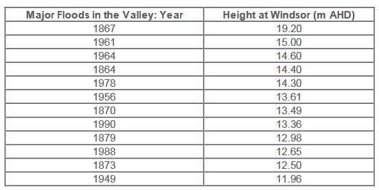 Source: SW SES, 2005, Hawkesbury/Nepean Flood Emergency Sub Plan, NSW State Disaster Plan.
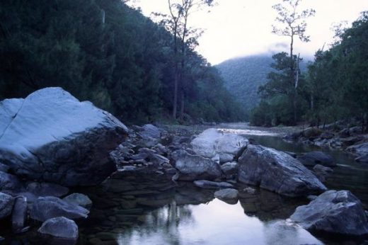


")


")


")


")
")
")


")


