Archive for the ‘Threats from Mining’ Category
Monday, October 24th, 2011
")
A New South Wales mining company has committed to pay $1.45 million after causing damage to a nationally threatened ecological community.
An investigation by the federal environment department found that the long wall coal mining operations of Centennial Coal on the Newnes Plateau, near Lithgow, New South Wales, had caused a significant impact on the endangered Temperate highland peat swamps on sandstone ecological community.
The mining activities caused a loss of ecosystem function shown by loss of peat, erosion, vegetation dieback and weed invasion in three swamps.
They also caused the formation of a large slump hole, several metres wide and more than one metre deep, at the East Wolgan Swamp.
These changes mean the swamps can no longer serve their important hydrological role of acting as water filters and releasing water slowly to downstream watercourses.
Centennial Coal will pay $1.45 million towards a research program to be administered by the Fenner School of Environment and Society at the Australian National University.
This research program will be of great conservation benefit for these protected swamps and inform better understanding of the impacts of land use change.
The program will map the distribution and extent of the swamps, explore their functions, water dynamics, ecology and history, and look at human impacts on the swamps. It will provide valuable knowledge to protect Temperate highland peat swamps on sandstone and to promote land management practices that minimise impacts on these swamps.
The payment will be made as an ‘enforceable undertaking’ under national environment law—the Environment Protection and Biodiversity Conservation Act 1999.
This is an effective way to hold companies accountable for environmental damage without going through lengthy and costly legal proceedings.
This outcome shows the Australian Government takes environmental protection seriously, and will not tolerate companies causing needless damage to the environment.
.
[Source: ‘Mining company to pay for environmental damage’, 20111021, by Justin McKee, ‘Gardens of Stone’ Campaigner, Blue Mountains Conservation Society]
.
Editor: If the New South Wales (NSW) Government agency responsible and accountable for environmental protection of threatened species cannot do its job and it takes the federal government agency to do its job for it , then the NSW agency is redundant and should be dissolved and responsibility handed to the federal government.
.
.
 Swamp on Newnes Plateau, Blue Mountains region
.
‘Blue Mountains Swamps are a biologically diverse plant community that occurs nowhere else in the world. The vegetation in these swamps range from low buttongrass clumps to large shrubs such as Hakea and Grevillea species. The swamps provide essential habitat to several Threatened Species, such as the Blue Mountains Water Skink (Eulamprus leuraensis) and the Giant Dragonfly (Petalura gigantea).
.
Blue Mountains swamps play a vital part in maintaining the water flows in the areas creeks and waterfalls, by storing water and slowly releasing it over time. Swamps also act as filters, purifying water prior to the release into creeks. Other threatened species such as Epacris hamiltonii and Microstrobos fitzgeraldii rely on the continued seepage from hanging swamps for survival in their specialized habitats.
.
There are less than 3,000 ha of Blue Mountains Swamp in existence. As they predominantly comprise many small areas, they are very susceptible to edge effects.’.[Source: Blue Mountains Council, ^http://www.bmcc.nsw.gov.au/sustainableliving/environmentalinformation/livingcatchments/swampsandswampcare]
.
.
Swamps on Newnes Plateau provide critical habitat for the endangered Blue Mountains Water Skink
")
‘The Blue Mountains Water Skink (Eulamprus leuraensis) is a medium sized semi- aquatic lizard. It is one of Australia’s rarest lizards, and has only been found in 30 locations in the middle and upper Blue Mountains in New South Wales. Surveys suggest that the Blue Mountains Water Skink is restricted to an isolated, highly fragmented habitat of sedge and shrub swamps that occur between Newnes in the north and west and Hazelbrook in the south and east. Potential habitat to the south and northwest of known sites may extend the range of this species, however further survey work is required to determine whether the species utilises these areas.
The small number and apparent isolation of known populations, in conjunction with the limited geographic distribution of the Blue Mountains Water Skink make it vulnerable to the operation of threatening processes. Clearing for urban development and associated disturbance to habitat has resulted in the reduction of the area of known and potential habitat and the apparent extinction from areas where this species previously occurred. The small size of some swamps increases the risk of loss of one or more of the populations, and recolonisation of disjunct areas appears unlikely (LeBreton 1994c).
Possible threats include urban development (some locations are almost completely surrounded by houses and other locations have land zoned for further development adjacent to them), pollution and sedimentation (including stormwater run-off), alterations to hydrological regimes (through construction of roads, tracks, plantations and mining subsidence), weed invasion, visitor disturbance (trail bikes, 4WD) and predation by cats.
This recovery plan describes our current understanding of the Blue Mountains Water Skink and documents the research and management actions undertaken to date. The plan also identifies the parties responsible for the management actions required to ensure the ongoing viability of the species in the wild.
") Known distribution of the Endangered Blue Mountains Water Skink Known distribution of the Endangered Blue Mountains Water Skink
.
‘The species has been listed as Endangered for the following reasons. It is an ecological specialist and is restricted to a highly fragmented montane swamp habitat. Many populations appear isolated and the small size of some swamps makes them vulnerable to ‘edge effects’ and increases the risk of loss of one or more populations through chance events. The ability of the Blue Mountains Water Skink to recolonise an area in the event of a local extinction may be low as a result of the discontinuity of the habitat and the apparently limited scope for dispersal (LeBreton 1996). These factors in conjunction with the limited geographic distribution of the Blue Mountains Water Skink make it particularly vulnerable to the operation of threatening processes.
A substantial number of known sites are located wholly or partially in national park (17 locations). The most significant threat facing these populations may be further urbanisation of adjacent areas as several of the sites occur in close proximity to residential areas or areas zoned for residential development. Other threats may include disturbance by visitors, invasion by weeds, inappropriate fire regimes and predation by cats.
Eight populations are recorded at Newnes Plateau on land managed by SFNSW. These populations may also face threats from weed invasion, inappropriate fire regimes and predation by cats. They could also face threats associated with timber harvesting activities and mining subsidence.’
.
[Source: The Recovery Plan for the Blue Mountains Water Skink (Eulamprus leuraensis), NSW National Parks and Wildlife Service, 200106, ISBN 0 7313 6283 7, ^http://www.environment.gov.au/biodiversity/threatened/publications/recovery/blue-mtns-water-skink/index.html]
.
.
Longwall Mining declared a ‘Key Threatening Process’ since 2005…hello!
.In 2005, the Scientific Committee, established by the Threatened Species Conservation Act, has made a Final Determination to list Alteration of habitat following subsidence due to longwall mining as a KEY THREATENING PROCESS in Schedule 3 of the Act. Listing of key threatening processes is provided for by Part 2 of the Act.The Scientific Committee has found that:
1. Longwall mining occurs in the Northern, Southern and Western Coalfields of NSW. The Northern Coalfields are centred on the Newcastle-Hunter region. The Southern Coalfield lies principally beneath the Woronora, Nepean and Georges River catchments approximately 80-120 km SSW of Sydney. Coalmines in the Western Coalfield occur along the western margin of the Sydney Basin. Virtually all coal mining in the Southern and Western Coalfields is underground mining.
2. Longwall mining involves removing a panel of coal by working a face of up to 300 m in width and up to two km long. Longwall panels are laid side by side with coal pillars, referred to as “chain pillars” separating the adjacent panels. Chain pillars generally vary in width from 20-50 m wide (Holla and Barclay 2000). The roof of the working face is temporarily held up by supports that are repositioned as the mine face advances (Karaman et al. 2001). The roof immediately above the coal seam then collapses into the void (also known as the goaf) and a collapse zone is formed above the extracted area. This zone is highly fractured and permeable and normally extends above the seam to a height of five times the extracted seam thickness (typical extracted seam thickness is approximately 2-3.5 m) (ACARP 2002). Above the collapse zone is a fractured zone where the permeability is increased to a lesser extent than in the collapse zone. The fractured zone extends to a height above the seam of approximately 20 times the seam thickness, though in weaker strata this can be as high as 30 times the seam thickness (ACARP 2002). Above this level, the surface strata will crack as a result of bending strains, with the cracks varying in size according to the level of strain, thickness of the overlying rock stratum and frequency of natural joints or planes of weakness in the strata (Holla and Barclay 2000).
3. The principal surface impact of underground coal mining is subsidence (lowering of the surface above areas that are mined) (Booth et al. 1998, Holla and Barclay 2000). The total subsidence of a surface point consists of two components, active and residual. Active subsidence, which forms 90 to 95% of the total subsidence in most cases, follows the advance of the working face and usually occurs immediately. Residual subsidence is time-dependent and is due to readjustment and compaction within the goaf (Holla and Barclay 2000). Trough-shaped subsidence profiles associated with longwall mining develop tilt between adjacent points that have subsided different amounts. Maximum ground tilts are developed above the edges of the area of extraction and may be cumulative if more than one seam is worked up to a common boundary. The surface area affected by ground movement is greater than the area worked in the seam (Bell et al. 2000). In the NSW Southern Coalfield, horizontal displacements can extend for more than one kilometre from mine workings (and in extreme cases in excess of three km) (ACARP 2002, 2003), although at these distances, the horizontal movements have little associated tilt or strain. Subsidence at a surface point is due not only to mining in the panel directly below the point, but also to mining in the adjacent panels. It is not uncommon for mining in each panel to take a year or so and therefore a point on the surface may continue to experience residual subsidence for several years (Holla and Barclay 2000).
4. The degree of subsidence resulting from a particular mining activity depends on a number of site specific factors. Factors that affect subsidence include the design of the mine, the thickness of the coal seam being extracted, the width of the chain pillars, the ratio of the depth of overburden to the longwall panel width and the nature of the overlying strata; sandstones are known to subside less than other substrates such as shales. Subsidence is also dependent on topography, being more evident in hilly terrain than in flat or gently undulating areas (Elsworth and Liu 1995, Holla 1997, Holla and Barclay 2000, ACARP 2001). The extent and width of surface cracking over and within the vicinity of the mined goaf will also decrease with an increased depth of mining (Elsworth and Liu 1995).
5. Longwall mining can accelerate the natural process of ‘valley bulging’ (ACARP 2001, 2002). This phenomenon is indicated by an irregular upward spike in an otherwise smooth subsidence profile, generally co-inciding with the base of the valley. The spike represents a reduced amount of subsidence, known as ‘upsidence’, in the base and sides of the valley and is generally coupled with the horizontal closure of the valley sides (ACARP 2001, 2002). In most cases, the upsidence effects extend outside the valley and include the immediate cliff lines and ground beyond them (ACARP 2002).
6. Mining subsidence is frequently associated with cracking of valley floors and creeklines and with subsequent effects on surface and groundwater hydrology (Booth et al. 1998, Holla and Barclay 2000, ACARP 2001, 2002, 2003). Subsidence-induced cracks occurring beneath a stream or other surface water body may result in the loss of water to near-surface groundwater flows. If the water body is located in an area where the coal seam is less than approximately 100-120 m below the surface, longwall mining can cause the water body to lose flow permanently. If the coal seam is deeper than approximately 150 m, the water loss may be temporary unless the area is affected by severe geological disturbances such as strong faulting. In the majority of cases, surface waters lost to the sub-surface re-emerge downstream. The ability of the water body to recover is dependent on the width of the crack, the surface gradient, the substrate composition and the presence of organic matter. An already-reduced flow rate due to drought conditions or an upstream dam or weir will increase the impact of water loss through cracking. The potential for closure of surface cracks is improved at sites with a low surface gradient although even temporary cracking, leading to loss of flow, may have long-term effects on ecological function in localised areas. The steeper the gradient, the more likely that any solids transported by water flow will be moved downstream allowing the void to remain open and the potential loss of flows to the subsurface to continue. A lack of thick alluvium in the streambed may also prolong stream dewatering (by at least 13 years, in one case study in West Virginia, Gill 2000). Impacts on the flows of ephemeral creeks are likely to be greater than those on permanent creeks (Holla and Barclay 2000). Cracking and subsequent water loss can result in permanent changes to riparian community structure and composition.
 Longwall Mining Consequences
Total Environment Centre, ^http://www.tec.org.au/component/docman/doc_view/201-longwall-rep07 Longwall Mining Consequences
Total Environment Centre, ^http://www.tec.org.au/component/docman/doc_view/201-longwall-rep07
.
7. Subsidence can also cause decreased stability of slopes and escarpments, contamination of groundwater by acid drainage, increased sedimentation, bank instability and loss, creation or alteration of riffle and pool sequences, changes to flood behaviour, increased rates of erosion with associated turbidity impacts, and deterioration of water quality due to a reduction in dissolved oxygen and to increased salinity, iron oxides, manganese, and electrical conductivity (Booth et al. 1998, Booth and Bertsch 1999, Sidle et al. 2000, DLWC 2001, Gill 2000, Stout 2003). Displacement of flows may occur where water from mine workings is discharged at a point or seepage zone remote from the stream, and in some cases, into a completely different catchment. Where subsidence cracks allow surface water to mix with subsurface water, the resulting mixture may have altered chemical properties. The occurrence of iron precipitate and iron-oxidising bacteria is particularly evident in rivers where surface cracking has occurred. These bacteria commonly occur in Hawkesbury Sandstone areas, where seepage through the rock is often rich in iron compounds (Jones and Clark 1991) and are able to grow in water lacking dissolved oxygen. Where the bacteria grow as thick mats they reduce interstitial habitat, clog streams and reduce available food (DIPNR 2003). Loss of native plants and animals may occur directly via iron toxicity, or indirectly via smothering. Long-term studies in the United States indicate that reductions in diversity and abundance of aquatic invertebrates occur in streams in the vicinity of longwall mining and these effects may still be evident 12 years after mining (Stout 2003, 2004).8. The extraction of coal and the subsequent cracking of strata surrounding the goaf may liberate methane, carbon dioxide and other gases. Most of the gas is removed by the ventilation system of the mine but some gas remains within the goaf areas. Gases tend to diffuse upwards through any cracks occurring in the strata and be emitted from the surface (ACARP 2001). Gas emissions can result in localised plant death as anaerobic conditions are created within the soil (Everett et al. 1998).
9. Subsidence due to longwall mining can destabilise cliff-lines and increase the probability of localised rockfalls and cliff collapse (Holla and Barclay 2000, ACARP 2001, 2002). This has occurred in the Western Coalfield and in some areas of the Southern Coalfield (ACARP 2001). These rockfalls have generally occurred within months of the cliffline being undermined but in some cases up to 18 years after surface cracking first became visible following mining (ACARP 2001). Changes to cliff-line topography may result in an alteration to the environment of overhangs and blowouts. These changes may result in the loss of roosts for bats and nest sites for cliff-nesting birds.
10. Damage to some creek systems in the Hunter Valley has been associated with subsidence due to longwall mining. Affected creeks include Eui Creek, Wambo Creek, Bowmans Creek, Fishery Creek and Black Creek (Dept of Sustainable Natural Resources 2003, in lit.). Damage has occurred as a result of loss of stability, with consequent release of sediment into the downstream environment, loss of stream flow, death of fringing vegetation, and release of iron rich and occasionally highly acidic leachate. In the Southern Coalfields substantial surface cracking has occurred in watercourses within the Upper Nepean, Avon, Cordeaux, Cataract, Bargo, Georges and Woronora catchments, including Flying Fox Creek, Wongawilli Creek, Native Dog Creek and Waratah Rivulet. The usual sequence of events has been subsidence-induced cracking within the streambed, followed by significant dewatering of permanent pools and in some cases complete absence of surface flow.
11. The most widely publicised subsidence event in the Southern Coalfields was the cracking of the Cataract riverbed downstream of the Broughtons Pass Weir to the confluence of the Nepean River. Mining in the vicinity began in 1988 with five longwall panels having faces of 110 m that were widened in 1992 to 155 m. In 1994, the river downstream of the longwall mining operations dried up (ACARP 2001, 2002). Water that re-emerged downstream was notably deoxygenated and heavily contaminated with iron deposits; no aquatic life was found in these areas (Everett et al. 1998). In 1998, a Mining Wardens Court Hearing concluded that 80% of the drying of the Cataract River was due to longwall mining operations, with the balance attributed to reduced flows regulated by Sydney Water. Reduction of the surface river flow was accompanied by release of gas, fish kills, iron bacteria mats, and deterioration of water quality and instream habitat. Periodic drying of the river has continued, with cessation of flow recorded on over 20 occasions between June 1999 and October 2002 (DIPNR 2003). At one site, the ‘Bubble Pool”, localised water loss up to 4 ML/day has been recorded (DIPNR 2003). Piezometers indicated that there was an unusually high permeability in the sandstone, indicating widespread bedrock fracturing (DIPNR 2003). High gas emissions within and around areas of dead vegetation on the banks of the river have been observed and it is likely that this dieback is related to the generation of anoxic conditions in the soil as the migrating gas is oxidised (Everett et al. 1998). An attempt to rectify the cracking by grouting of the most severe crack in 1999 was only partially successful (AWT 2000). In 2001, water in the Cataract River was still highly coloured, flammable gas was still being released and flow losses of about 50% (3-3.5 ML/day) still occurring (DLWC 2001). Environmental flow releases of 1.75 ML/day in the Cataract River released from Broughtons Pass Weir were not considered enough to keep the river flowing or to maintain acceptable water quality (DIPNR 2003).
12. Subsidence associated with longwall mining has contributed to adverse effects (see below) on upland swamps. These effects have been examined in most detail on the Woronora Plateau (e.g. Young 1982, Gibbins 2003, Sydney Catchment Authority, in lit.), although functionally similar swamps exist in the Blue Mountains and on Newnes Plateau and are likely to be affected by the same processes. These swamps occur in the headwaters of the Woronora River and O’Hares Creek, both major tributaries of the Georges River, as well as major tributaries of the Nepean River, including the Cataract and Cordeaux Rivers. The swamps are exceptionally species rich with up to 70 plant species in 15 m2 (Keith and Myerscough 1993) and are habitats of particular conservation significance for their biota. The swamps occur on sandstone in valleys with slopes usually less than ten degrees in areas of shallow, impervious substrate formed by either the bedrock or clay horizons (Young and Young 1988). The low gradient, low discharge streams cannot effectively flush sediment so they lack continuous open channels and water is held in a perched water table. The swamps act as water filters, releasing water slowly to downstream creek systems thus acting to regulate water quality and flows from the upper catchment areas (Young and Young 1988).
13. Upland swamps on the Woronora Plateau are characterised by ti-tree thicket, cyperoid heath, sedgeland, restioid heath and Banksia thicket with the primary floristic variation being related to soil moisture and fertility (Young 1986, Keith and Myerscough 1993). Related swamp systems occur in the upper Blue Mountains including the Blue Mountains Sedge Swamps (also known as hanging swamps) which occur on steep valley sides below an outcropping claystone substratum and the Newnes Plateau Shrub Swamps and Coxs River Swamps which are also hydrologically dependent on the continuance of specific topographic and geological conditions (Keith and Benson 1988, Benson and Keith 1990). The swamps are subject to recurring drying and wetting, fires, erosion and partial flushing of the sediments (Young 1982, Keith 1991). The conversion of perched water table flows into subsurface flows through voids, as a result of mining-induced subsidence may significantly affect the water balance of upland swamps (eg Young and Wray 2000). The scale of this impact is currently unknown, however, changes in vegetation may not occur immediately. Over time, areas of altered hydrological regime may experience a modification to the vegetation community present, with species being favoured that prefer the new conditions. The timeframe of these changes is likely to be long-term. While subsidence may be detected and monitored within months of a mining operation, displacement of susceptible species by those suited to altered conditions is likely to extend over years to decades as the vegetation equilibrates to the new hydrological regime (Keith 1991, NPWS 2001). These impacts will be exacerbated in periods of low flow. Mine subsidence may be followed by severe and rapid erosion where warping of the swamp surface results in altered flows and surface cracking creates nick-points (Young 1982). Fire regimes may also be altered, as dried peaty soils become oxidised and potentially flammable (Sydney Catchment Authority, in lit.) (Kodela et al. 2001).
14. The upland swamps of the Woronora Plateau and the hanging swamps of the Blue Mountains provide habitat for a range of fauna including birds, reptiles and frogs. Reliance of fauna on the swamps increases during low rainfall periods. A range of threatened fauna including the Blue Mountains Water Skink, Eulamprus leuraensis, the Giant Dragonfly, Petalura gigantea, the Giant Burrowing Frog, Heleioporus australiacus, the Red-crowned Toadlet, Pseudophryne australis, the Stuttering Frog Mixophyes balbus and Littlejohn’s Tree Frog, Litoria littlejohni, are known to use the swamps as habitat. Of these species, the frogs are likely to suffer the greatest impacts as a result of hydrological change in the swamps because of their reliance on the water within these areas either as foraging or breeding habitat. Plant species such as Persoonia acerosa, Pultenaea glabra, P. aristata and Acacia baueri ssp. aspera are often recorded in close proximity to the swamps. Cliffline species such as Epacris hamiltonii and Apatophyllum constablei that rely on surface or subsurface water may also be affected by hydrological impacts on upland swamps, as well as accelerated cliff collapse associated with longwall mining.
15. Flora and fauna may also be affected by activities associated with longwall mining in addition to the direct impacts of subsidence. These activities include clearing of native vegetation and removal of bush rock for surface facilities such as roads and coal wash emplacement and discharge of mine water into swamps and streams. Weed invasion, erosion and siltation may occur following vegetation clearing or enrichment by mine water. Clearing of native vegetation, Bushrock removal, Invasion of native plant communities by exotic perennial grasses and Alteration to the natural flow regimes of rivers and streams and their floodplains and wetlands are listed as Key Threatening Processes under the Threatened Species Conservation Act (1995).
The following threatened species and ecological communities are known to occur in areas affected by subsidence due to longwall mining and their habitats are likely to be altered by subsidence and mining-associated activities:
.
Endangered Species
-
Epacris hamiltonii a shrub
-
Eulamprus leuraensis Blue Mountains Water Skink
-
Hoplocephalus bungaroides Broad-headed Snake
-
Isoodon obesulus Southern Brown Bandicoot
-
Petalura gigantea Giant Dragonfly
.
Vulnerable species
- Acacia baueri subsp. aspera
- Apatophyllum constablei
- Boronia deanei
- Cercartetus nanus Eastern Pygmy Possum
- Epacris purpurascens var. purpurascens
- Grevillea longifolia
- Heleioporus australiacus Giant Burrowing Frog
- Ixobrychus flavicollis Black Bittern
- Leucopogon exolasius
- Litoria littlejohni Littlejohn’s Tree Frog
- Melaleuca deanei
- Mixophyes balbus Stuttering Frog
- Myotis adversus Large-footed Myotis
- Persoonia acerosa
- Potorous tridactylus Long-nosed Potoroo
- Pseudophryne australis Red-crowned Toadlet
- Pteropus poliocephalus Grey-headed Flying Fox
- Pterostylis pulchella
- Pultenaea aristata
- Pultenaea glabra
- Tetratheca juncea
- Varanus rosenbergi Rosenberg’s Goanna
.
Endangered Ecological Communities
- Genowlan Point Allocasuarina nana Heathland
- Newnes Plateau Shrub Swamp in the Sydney Basin Bioregion
- O’Hares Creek Shale Forest
- Shale/Sandstone Transition Forest
.
Species and populations of species not currently listed as threatened but that may become so as a result of habitat alteration following subsidence due to longwall mining include:
- Acacia ptychoclada
- Almaleea incurvata
- Darwinia grandiflora
- Dillwynia stipulifera
- Epacris coricea
- Grevillea acanthifolia subsp. acanthifolia
- Hydromys chrysogaster Water rat
- Lomandra fluviatilis
- Olearia quercifolia
- Pseudanthus pimelioides
.
16. Mitigation measures to repair cracking creek beds have had only limited success and are still considered experimental (ACARP 2002). Cracks less than 10 mm wide may eventually reseal without active intervention provided there is a clay fraction in the soil and at least some water flow is maintained. Cracks 10-50 mm wide may be sealed with a grouting compound or bentonite. Cracks wider than 50 mm require concrete (ACARP 2002). Pattern grouting in the vicinity of Marhnyes Hole in the Georges River has been successful at restoring surface flows and reducing pool drainage following fracturing of the riverbed (International Environmental Consultants 2004). Grouting of cracks also appears to have been relatively effective in Wambo Creek in the Hunter Valley. Installation of a grout curtain in the Cataract River, however, has been only partially successful and it was concluded in 2002, after rehabilitation measures had taken place, that the environment flows released from Broughtons Pass Weir by the Sydney Catchment Authority were insufficient to keep the Cataract River flowing or to maintain acceptable water quality (DIPNR 2003). Mitigation measures themselves may have additional environmental impacts due to disturbance from access tracks, the siting of drilling rigs, removal of riparian vegetation, and unintended release of the grouting material into the water. Furthermore, even measures that are successful in terms of restoring flows involve temporary rerouting of surface flows while mitigation is carried out (generally for 2-3 weeks at each grouting site). Planning for remediation measures may also be hampered by the lack of predictability of some impacts, and difficulties gaining access to remote areas where remedial works are needed. The long-term success of mitigation measures such as grouting is not yet known. It is possible that any ongoing subsidence after grouting may reopen cracks or create new ones. Further, it is not yet known whether the clay substance bentonite, which is often added to the cement in the grouting mix, is sufficiently stable to prevent shrinkage. Grouting under upland and hanging swamps that have no definite channel is probably not feasible.17. Empirical methods have been developed from large data sets to predict conventional subsidence effects (ACARP 2001, 2002, 2003). In general, these models have proved more accurate when predicting the potential degree of subsidence in flat or gently undulating terrain than in steep topography (ACARP 2003). A major issue identified in the ACARP (2001, 2002) reports was the lack of knowledge about horizontal stresses in geological strata, particularly those associated with river valleys. These horizontal stresses appear to play a major role in the magnitude and extent of surface subsidence impacts. The cumulative impacts of multiple panels also appear to have been poorly monitored. The general trend in the mining industry in recent years toward increased panel widths (from 200 up to 300 m), which allows greater economies in the overall costs of extraction, means that future impacts will tend to be greater than those in the past (ACARP 2001, 2002).18. In view of the above the Scientific Committee is of the opinion that Alteration of habitat following subsidence due to longwall mining adversely affects two or more threatened species, populations or ecological communities, or could cause species, populations or ecological communities that are not threatened to become threatened.’
.
by Dr Lesley Hughes, Chairperson, Scientific Committee, Proposed Gazettal date: 15/07/05
[Source: ^http://www.environment.nsw.gov.au/determinations/LongwallMiningKtp.htm]
.
.
Further Reading:
.
[1] Colong Foundation for Wilderness Ltd ^http://www.colongwilderness.org.au/Gardens_of_Stone/GoS2_Swamp_monitoring.htm
.
[2] ‘NPWS confirms long wall mining is a key threatening process‘, ^http://archive.lee.greens.org.au/index.php/content/view/1345/65/
.
[3] ‘Impacts of Longwall Coal Mining on the Environment in New South Wales‘ report, Total Environment Centre ^http://www.tec.org.au/component/docman/doc_view/201-longwall-rep07 [Read Report]
.
[4] The BushDoctor Pty Ltd, ^http://www.bushdoctor.com.au/experience_blueMountains.htm
.
[5] The Scientific Committee of NSW, Determination on Longwall Mining, 20050715, ^http://www.environment.nsw.gov.au/determinations/LongwallMiningKtp.htm]
.
[6] ‘Blue Mountains Water Skink Recovery Plan‘, National Parks and Wildlife Service 2001, [Read Plan]
.
Tags: Blue Mountains, Blue Mountains Conservation Society, Blue Mountains Sedge Swamps, Blue Mountains Water Skink, Centennial Coal, Colong Foundation for Wilderness, East Wolgan Swamp, enforceable undertaking, Environment Protection and Biodiversity Conservation Act 1999, Epacris hamiltonii, Fenner School of Environment and Society, Giant Dragonfly, hanging swamps, long wall coal mining, loss of ecosystem function, Microstrobos fitzgeraldii, Newnes Plateau, Subsidence due to longwall mining, threatened ecological community
Posted in Blue Mountains (AU), Threats from Mining | No Comments »
Add this post to Del.icio.us - Digg
Tuesday, August 9th, 2011
 Pilliga Forest
The early morning sun illuminates fresh forest grasses
beneath a stand of young native White Cypress Pine (Callitris glaucophylla), Feb 2010
^http://huntervalleyjournal.blogspot.com/2010_02_01_archive.html Pilliga Forest
The early morning sun illuminates fresh forest grasses
beneath a stand of young native White Cypress Pine (Callitris glaucophylla), Feb 2010
^http://huntervalleyjournal.blogspot.com/2010_02_01_archive.html
.
The Pilliga Forests
.
‘The Pilliga‘, also traditionally known as ‘The Pilliga Scrub‘ is a vast western woodland – the largest continuous remnant of semi-arid woodland in temperate New South Wales, Australia. The Pilliga comprises the largest remaining area of native forest west of the Great Dividing Range, covering about 500,000 hectares between the Namoi River in the North and Warrumbungle Ranges in the South. The Pilliga is part of the Brigalow Belt South bioregion. Australian land mass is divided into 85 bioregions. Each bioregion is a large geographically distinct area of similar climate, geology, landform, vegetation and animal communities. [Read More]
The Pilliga is characterised by native white cypress and iron bark forests, broom bush plains, vivid spring flowers and abundant fauna. The forest contains at least 300 native animal species, with at least 22 endangered animal species including such favorites as the Glossy Black-Cockatoo, Squirrel Glider, Koala, Pilliga Mouse (Pseudomys pilligaensis) and Rufous Bettong, and at least 900 plant species including species now widely grown in cultivation as well as many threatened plant species. The forest spans about 3,000 square kilometres of land. Some towns that surround the forest include Narrabri, Pilliga, Gwabegar, Baradine, Coonabarabran, Boggabri and Baan Baa. Some areas of the forest, particularly in the Western Pilliga, are completely dominated by “cypress pine” (Callitris spp.), however there are a vast number of distinct plant communities in the forest, some of which do not include Callitris pine. Another dominant sub-canopy genus are the Casuarinas, while Eucalypts dominate the canopy throughout the forest. Much of the area is State Forest under the management of the New South Wales Government, which effectively means that it is unprotected.
The name ‘Pilliga’ (or ‘Billarga‘) is an Aboriginal word meaning swamp oak (Casuarina trees). The name was borrowed back in the mid 1800’s as the name of one of the original grazing runs, near where the town of Pilliga now stands. [This theory is contracted by Les Murray in his Forward in Eric Rolls‘ seminal 1981 book ‘A Million Wild Acres‘, who accounts at page iv…”the Pilliga (from Kamilaroi peelaka, a spearhead”).
")
The geology of the area is dominated by the Pilliga Sandstone, a coarse red/yellow Jurassic sandstone containing about 75% quartz, 15% plagioclase and 10% iron oxide,[2] although local variations in soil type do occur. Sandstone outcrops with basalt-capped ridges are common in the south, while the Pilliga outwash areas to the north and west are dominated by alluvial sediment from the sandy, flooding creeks.
") Nuable Creek in flood, Pilliga 2004
Source: David Brodrick, 2004, ^http://www.narrabriweather.net/events/10Dec2004.html Nuable Creek in flood, Pilliga 2004
Source: David Brodrick, 2004, ^http://www.narrabriweather.net/events/10Dec2004.html
.
There is a vast network of roads throughout the scrub, many of which are former forestry roads. The forest once supported a large forestry industry in the surrounding towns (harvesting mostly cypress pine and ironbarks) however this has been greatly scaled back since 2005 when much of the forest was set aside for environmental conservation by the NSW government.
[Sources: ^ http://en.wikipedia.org/wiki/Pilliga_forest, ^ http://narrabri.net/Document1.aspx?id=1872]

According to the Narrabri Shire Visitor Information Centre, the Pilliga Forest… ‘is one of the largest native cypress forests in Australia and hosts an abundance of wildlife including koalas, kangaroos, possums, echidnas, goannas, emus and its very own species of mouse, the Pilliga Mouse. The area is renowned for its glorious wildflowers which can be found in the Forest year round, with particularly impressive displays in Spring. The Baradine Community has developed three wildflower routes through the Forest. The “Wildflowers of Baradine and the Pilliga’.
[Source: ^ http://www.visitnarrabri.cfm.predelegation.com/index.cfm?page_id=1051&page_name=Wildflowers%20in%20the%20Pilliga]
.
.
.
‘The Pilliga’..after rain
.

‘Prolific rain on the northwest plains of New South Wales
quickly results in a swelling of rivers and creeks,
followed by a profusion of growth and renewal.
.
Many centimetres of very welcome rain covered the black soil grazing pastures and agricultural properties
surrounding the village of Baradine over the first weekend of February, 2010.
We were there to witness this amazing natural event.
Sheets of water rapidly cover the vast plains,
draining into gullies and creeks, and filling rivers.
Many outlying unsealed roads become impassable,
and the town is temporarily isolated.
But life goes on with relative normality,
albeit with joyous appreciation of the blessings the downpour will bring.’
[Source: HunterValleyJournal, http://huntervalleyjournal.blogspot.com/2010_02_01_archive.html, Feb. 2010,]
.
.
Where is ‘The Pilliga’?
 Location of ‘The Pilliga’ as shown by the distribution map of the native Pilliga Mouse
Australian Department of Environment et al.
[Source: ^http://www.environment.gov.au/cgi-bin/sprat/public/publicspecies.pl?taxon_id=99#recovery_plan_loop] Location of ‘The Pilliga’ as shown by the distribution map of the native Pilliga Mouse
Australian Department of Environment et al.
[Source: ^http://www.environment.gov.au/cgi-bin/sprat/public/publicspecies.pl?taxon_id=99#recovery_plan_loop]
.
") The Pilliga Forests
lie between the towns of Coonabrabran in the south and Narrabri in the north
situated in north western New South Wales in the Brigalow Belt South bioregion.
[Source: ^http://maps.bonzle.com/c/a?a=p&p=56925&cmd=sp] The Pilliga Forests
lie between the towns of Coonabrabran in the south and Narrabri in the north
situated in north western New South Wales in the Brigalow Belt South bioregion.
[Source: ^http://maps.bonzle.com/c/a?a=p&p=56925&cmd=sp]
.
.
The Pilliga’s history of colonial exploitation
.
‘Following many thousands of years of Aboriginal occupation, European settlers started arriving around the early 1830’s. These settlers established grazing runs throughout the forests, which then comprised a few well-scattered large trees over a grassy understorey. Aboriginal burning and grazing by Kangaroo Rats had kept the forest floor clear of regeneration until that time.

The introduction of cattle and sheep resulted in significant ecological changes. The soils deteriorated and the mix (and grazing quality) of the native grasses changed. The Kangaroo rats were displaced. The 1970’s and 1880’s produced a prolonged drought that saw most of the grazing runs abandoned. Then, during the late 1880’s and early 1890’s, there was a succession of good seasons and, in the absence of grazing pressure and regular burning; massive regeneration of native cypress and eucalyptus took place across much of the Pilliga.
The spread of rabbits to the area in the early 1900’s prevented any further regeneration events in the Pilliga until the introduction of myxomatosis in the 1950’s. With the demise of the Rabbit, a new pulse of young cypress and eucalypt seedlings was able to get up and away.
The cypress regeneration from the late 1800’s forms the basis of the timber industry operating from the Pilliga today. The 1950’s and subsequent growth is being managed to provide a sustainable supply of timber to industry for generations to come. In 1999, there were over 150 jobs dependant on the timber resources of the Pilliga and the industry provides the backbone of many small communities on the fringe of the Pilliga.
 Wooleybah Sawmill, Pillaga
(NSW Heritage Office) Wooleybah Sawmill, Pillaga
(NSW Heritage Office)
.
Between the 1920’s and mid 1990’s, over 5 million railway sleepers were cut from ironbark grown in the Pilliga.

Ironbark is still used to produce fence posts and drops for electric fencing systems, where the non-conductivity of its heartwood provides a unique advantage.’ [Source: ^http://narrabri.net/Document1.aspx?id=1872]
 The Pilliga is susceptible to bushfire – by lighting, arsonists and incompetence.
[Source: clubr8255’s photostream, http://www.flickr.com/photos/32053650@N03/with/3038473001/ The Pilliga is susceptible to bushfire – by lighting, arsonists and incompetence.
[Source: clubr8255’s photostream, http://www.flickr.com/photos/32053650@N03/with/3038473001/
.
.
The endemic ‘Pilliga Mouse’
")
‘Endemic‘ means found naturally nowhere else on the planet.
The Pilliga Mouse (Pseudomys pilligaensis ) is a small native murid rodent found in the Pilliga Forests ecosystem. It is listed as Vulnerable in Australia and is endemic to the Pilliga Forests of New South Wales.
The Pilliga Mouse is very sparsely distributed and appears to prefer moist gullies, areas dominated by extensive coverage of low grasses and sedges, broombush and areas containing an understorey of kurricabah (Acacia burrowii) with a bloodwood (Corymbia trachyphloia) overstorey. It is nocturnal and appears to live in burrows.
Its main threats are from logging operations that destroy the understorey particularly broombush, inappropriate fire regimes (broadscale and frequent bushfire management), predation by ferals (foxes, cats and wild pigs/boars)
.
[Source: ^http://www.environment.gov.au/cgi-bin/sprat/public/publicspecies.pl?taxon_id=99]
.
.
The Pilliga… now threatened by Mining

‘Eastern Star Gas coal seam expansion in Pilliga under federal investigation’
(Article on ABC Rural, 20110721, ^http://www.abc.net.au/rural/news/content/201107/s3274633.htm]
.
The Federal Government is investigating whether Eastern Star Gas is in breach of the Environment Protection Biodiversity Conseration Act at its coal seam gas project in NSW’s Pilliga forest.
The project is expected to result in the first large-scale coal seam gas operation in NSW. The Pilliga forest is the largest remaining temperate woodland in eastern Australia.
Chief Executive Officer of the National Conservation Council, Pepe Clark is calling on Santos, which owns Eastern Star Gas, to either desist or defer work until they have Federal approval.
 A Silhouette of Pillage
Eastern Star Gas’s coal seam gas development in the Pilliga State Forest, A Silhouette of Pillage
Eastern Star Gas’s coal seam gas development in the Pilliga State Forest,
which is having a profound effect on the Bohema creek water quality and flow which flows into the Murray River
© The Wilderness Society, Photo by Dean Sewell, May 2011
.
.
‘Pilliga coal seam gas developments breach Federal environmental law: report’
(Article by Nature Conservation Council of NSW, 20110719, ^http://www.nccnsw.org.au/media/pilliga-coal-seam-gas-developments-breach-federal-environmental-law-report)
.
‘Eastern Star Gas has conducted coal seam gas exploration and production activities in the Pilliga forest without seeking federal assessment on matters of national environmental significance, according to a report by the Northern Inland Council for the Environment, The Wilderness Society and the Nature Conservation Council of NSW.
The report, Under the Radar, was released today following the recent purchase of Eastern Star Gas by one of Australia’s largest domestic gas producers, Santos.
 
“Eastern Star Gas has undertaken extensive coal seam gas exploration and production without seeking federal approval. This is likely to have damaged the habitat of iconic threatened species such as the Pilliga Mouse and the Regent Honeyeater,” said Warrick Jordan, Campaign Manager at the Wilderness Society Newcastle.
“Santos is taking on the most environmentally destructive and contentious gas project in NSW. As the new owner, Santos should look carefully at the damaging impacts of this proposal and immediately desist or refer all existing operations in the Pilliga for proper assessment.
“We are asking Tony Burke to immediately ‘call-in’ all existing Eastern Star Gas operations in the Pilliga under federal environment laws. Eastern Star should not be able to get away with destroying our natural heritage,” he said.

The Under the Radar report found coal seam gas operations in the Pilliga have cleared more than 150ha and fragmented 1,700ha of bushland, drilled 92 coal seam gas wells, constructed 56.6km of pipelines, and operated 35 production wells without seeking approval under the Federal EPBC Act. These activities have occurred in habitat for federally-listed threatened species, such as the South-Eastern Long-eared Bat.
“Under Commonwealth legislation, any potential impacts on nationally-threatened species must be referred to the Environment Department for approval. Eastern Star Gas has been flying under the radar to avoid this process in the Pilliga,” said Pepe Clarke, CEO of the Nature Conservation Council of NSW.
“Eastern Star has recently applied for Commonwealth approval for a large new coal seam gas field in the same area of the Pilliga as existing operations. If these future operations trigger federal environment laws, then so do the existing operations and Santos should immediately cease those operations and be refer them to the Federal Government”,” he said.
“The question remains, will Santos continue Eastern Star’s reckless attempts to turn the iconic Pilliga Forest into an industrial coal seam gas field? If Santos can’t be trusted to abide by environmental laws now, they cannot be trusted to manage the environmental impacts of NSW’ biggest coal seam gas development,” said Carmel Flint, of the Northern Inland Council for the Environment.
Under the Radar report summary
The Federal Environment Protection and Biodiversity Conservation Act 1999 (EPBC Act) makes it illegal to undertake an activity that has, or is likely to have, a significant impact on matters of national environment significance. These prohibitions are set down in Part 3 of the EPBC Act 1999, in s18 and s20 respectively.
There are at least 24 matters of national environmental significance, as defined by the EPBC Act, which occur within the Pilliga Forest section of the Eastern Star Gas Petroleum Exploration Licence 238 and Petroleum Assessment Lease 2. These include known, likely, and potential habitat for 15 nationally threatened species (4 endangered, 11 vulnerable), and known or potential habitat for 9 migratory birds listed under international conventions.
Environment groups have conducted a detailed assessment of the likely impacts of current coal seam gas activities in the Pilliga Forest on matters of national environmental significance, by applying the Guidelines for Significant Impact set down by the Department of Sustainability, Environment, Water, Population and Communities (SEWPaC). These are the same guidelines that should have been applied by Eastern Star Gas to assess the impacts of the activities.
The following coal seam gas activities have been undertaken in PEL 238 and PAL2:
1. The drilling and on-going management of more than 92 coal seam gas bores and coreholes
2. The conduct of 482km of seismic surveys
3. The construction and management of 56.6km of gas and water gathering pipelines
4. The development and management of five production fields, encompassing 35 production bores
5. The construction and management of a gas-fired power station at Wilga Park, including an upgrade of the station from 10MW to 40MW
6. The construction and operation of 1 reverse osmosis unit
7. The construction and management of 13 major water treatment dams/impoundments and numerous drill ponds
8. The discharge of treated produced water into the Bohena Ck, part of the Murray-Darling Basin.
9. The bull-dozing of numerous roads and tracks to facilitate the construction and operation of works listed above.
None of these activities, nor the whole action combined, has ever been referred to the Federal Government for consideration of the likely impacts on federally-listed species under the EPBC Act 1999. There is no Federal approval in place for the action.
The environmental impacts of these activities include: direct destruction of at least 150ha of native vegetation that is habitat for federally-listed species; heavy fragmentation of an area of 1,700 ha of native vegetation leading to the spread of invasive species; creation of artificial watering points at more than 13 different locations representing a risk to wildlife; introducing numerous sources of pollution through the use of chemicals and the handling and disposal of produced water; direct alteration of the ecology of a creek system for up to 22km; increased fire ignition sources and introduction of a flammable gas into an already fire prone environment; an overall disturbance footprint across 44,700ha of bushland.
Applying the Guidelines for Significant Impact, the report concludes that the impacts on federally-listed species are likely to be significant because of the intensity at which they have occurred, as well as:
- The extraordinary national and international conservation significance of the environment in which it is occurring;
- The sensitivity of the ecosystem given the scale of extinctions that have already occurred in the mammal fauna and the scale of decline now evident in the bird fauna;
- The substantial geographic area affected;
- The high cumulative impact in the context of other threats (other mining and gas developments, background clearing rates, climate change, invasive species, logging, and high intensity and frequent fires);
- The low level of confidence with which the impacts are understood; and
- the context in which it occurs of a heavily cleared and highly fragmented landscape with very low levels of reservation.
- The measures put in place by Eastern Star Gas to avoid or mitigate impacts are inadequate to prevent such impacts, and their effectiveness is uncertain and not scientifically established.
..
.
‘Farmers see threat in $900m Santos buyout’
(Article by Ben Cubby and Brian Robins, in Sydney Morning Herald, 20110719, ^http://www.smh.com.au/environment/farmers-see-threat-in-900m-santos-buyout-20110718-1hlq7.html)
.
‘A GAS exploration company chaired by the former deputy prime minister John Anderson will be bought out for $900 million, in a move expected to pave the way for the first large-scale coal seam gas drilling operation in NSW.
The resources giant Santos will buy Mr Anderson’s Eastern Star Gas, which has plans to drill more than 500 gas wells in the Pilliga scrub, near Narrabri, the largest surviving remnant of temperate woodland in eastern Australia.
The plan has already sparked fierce resistance from some farmers, who have said they will lock their gates rather than allow drilling rigs on their grazing land. Many are concerned that the controversial fracking technique, which can lead to groundwater contamination, will be used.
Santos said it recognised the objections people had to coal seam gas drilling, and would campaign to win public support.
”We are confident these issues can be addressed,” said the chief executive, David Knox. ”We’re going to set the right pace and bring [the community] along, as we prove things up … We recognise the criticality of working with local communities.”
Last month Santos launched a television advertising campaign, saying that coal seam gas was ”a fuel for the future” and that the company had previously forged good relationships with rural land-holders.
Mr Knox said the federal government’s introduction of a carbon price would increase demand for gas instead of coal, which generally had higher greenhouse gas emissions.
The acquisition will make Santos the state’s biggest holder of coal seam gasfields.
Opponents say the construction of hundreds of wells, and a network of roads linking them, would industrialise the landscape. ”What’s being allowed here is an uncontrolled experiment on the Australian environment,” said Drew Hutton, a campaigner with the anti-coal seam gas group Lock the Gate Alliance.
Initial surveys prepared for Eastern Star indicate the area is home to many threatened animal and plant species, including the Pilliga mouse, black-striped wallaby, glossy black cockatoo, painted honeyeater and barking owl.
From the beginning of June the Moree Plains Shire Council has placed a 60-day moratorium on seismic surveys, drilling or exploration for coal seam gas, to allow the council and community time to study the implications of proposals.
A report produced by the Wilderness Society said the project was of national significance and should be independently assessed by the federal Environment Minister, Tony Burke.
“The Pilliga project, if it proceeds, will have a devastating impact on the environment,” said a Wilderness Society campaigner, Warrick Jordan.
”It will clear 2410 hectares of valuable bushland across the eastern Pilliga, including in a state conservation area, pose risks to the Great Artesian Basin, produce massive amounts of saline water, and the associated pipelines and wells will impact surrounding agricultural areas.”
The Nature Conservation Council of NSW also said that work already done on the site meant it should be referred to the federal government.
Tony Pickard, a farmer whose land falls within the proposed gas well area, said the first he had heard of the proposal was on a government website that showed dots on his land representing gas wells. Mr Pickard has vowed not to allow drilling on his land.
A NSW Greens MP, Jeremy Buckingham, is travelling through the state speaking to people who oppose coal seam gas extraction.
”To have an energy giant like Santos move in and take over means that the project is much more likely to go ahead,” Mr Buckingham said.
 Santos footprints in The Pilliga Santos footprints in The Pilliga
.
‘Under the Radar – new report lifts the lid on Eastern Star Gas operations’
– Article by The Wilderness Society, [Source: ^http://www.wilderness.org.au/campaigns/coal-seam-gas/under-the-radar-new-report-lifts-the-lid-on-eastern-star-gas-operations]
.
‘Eastern Star Gas has been trashing parts of the Pilliga since 2004, avoiding environmental laws in the process. A new report by the Wilderness Society, the Northern Inland Council for the Environment, and the Nature Conservation Council has exposed this scandal.
The Pilliga Forest is home to a host of threatened species, including the Pilliga Mouse and the Regent Honeyeater. Many of these species are listed under the federal Environmental Protection and Biodiversity Conservation Act.
When a company wants to develop a project on a site with nationally listed threatened species, they are required by law to refer the project to the federal environment department.
Eastern Star Gas has been exploring for and producing coal seam gas in the Pilliga Forest since 2004. This has resulted, amongst other actions, in the clearing of 150 hectares of forest, fragmentation of a further 1700 hectares, and the dumping of waste water into creeks.
The ‘Under the Radar‘ (1.35MB – pdf) report concludes that Eastern Star Gas has impacted threatened species habitat, and should have sought federal environmental assessment for its operations. All current and proposed activities should be suspended, and assessed by the Commonwealth Environment Department.
Eastern Star Gas, after ignoring environmental legislation, now wants to build the biggest coal seam gas project in NSW in the Pilliga. They promote this destructive project as environmentally friendly and well managed.
Eastern Star has been exposed as a company that will get away with what it can if it thinks no-one is looking.
Well, now we are watching, and we’ll be ensuring, with your help, that the unique Pilliga Forest won’t become an industrial wasteland.’
.
.
‘A national treasure or an industrial wasteland?’
– Article by Carmel Flint in the Colong Bulletin, No. 241, July 2011, pp.1-2, reproduced with premission of The Colong Foundation for Wilderness, Inc.
.
Coal seam gas has recently emerged as a massive threat to the future of the Pilliga Forest, in north-west NSW. The Pilliga is located between Narrabri and Coonabarabran, and covers an extraordinary 500,000 hectares of intact and contiguous bushland.
") The Bibblewindi water pollution ponds are one of ten constructed during the Pilliga ‘exploration’ phase.
So far there are 1,100 well heads planned for gas extraction just in the eastern quarter of the Pilliga alone.
Photo: T Pickard The Bibblewindi water pollution ponds are one of ten constructed during the Pilliga ‘exploration’ phase.
So far there are 1,100 well heads planned for gas extraction just in the eastern quarter of the Pilliga alone.
Photo: T Pickard
One tends to run out of superlatives very quickly when it comes to the conservation significance of the Pilliga.
It is the largest temperate woodland left in eastern Australia and the southern recharge area for the Great Artesian Basin. It’s surface waters flow into the rivers of the Murray-Darling Basin. It is the single most important biodiversity refuge area remaining in the NSW Wheat-Sheep Belt.
The Pilliga is home to more than 25 threatened or migratory species that are listed under federal laws and at least 48 threatened species under NSW law. It includes the only known population of the endemic Pilliga Mouse, the largest Koala population in western NSW and the only known Black-striped Wallaby population in western NSW. It represents the national stronghold for populations of the Barking Owl and the Southeastern Long-eared Bat within eastern Australia.
It is an internationally recognised Important Bird Area, with particular significance for the Painted Honeyeater and Diamond Firetail. It is also recognised as an important part of the East Australian Bird Migration System, and is located in the Brigalow Belt South bioregion which is one of only 15 biodiversity hotspots recognised by the Federal Government across the nation. It is mostly public land, either State Forest, State Conservation Area or National Park, and it has recognised wilderness values.
Coal seam gas companies have been conducting exploration in the Pilliga for about 10 years now, and they have already done considerable damage. Under the guise of exploration, they have to date drilled 92 coal seam gas wells, constructed 46.2km of pipelines, conducted 394.2km of seismic surveys, constructed 1 gas compression station and 1 reverse osmosis unit, developed five pilot production fields encompassing 35 boreholes, produced and delivered gas to a local power station, constructed
10 major water treatment dams/impoundments, discharged produced water into a local creek system and bulldozed numerous roads and tracks. This, however, is just the tip of the iceberg. In April this year Eastern Star Gas applied to the Federal Government for
an environmental approval to move to full production in the Pilliga Forest.
They want to put in 1,100 wellheads and 1,000km of pipelines across the eastern section of the Pilliga, clearing at least 2,410 hectares and fragmenting 85,000 hectares.
.
Associated with this proposal are two pipelines – one to a proposed gas-fired power station at Wellington and another to a proposed new LNG export facility at Newcastle. By incorporating the first ever major LNG export facility, this Pilliga proposal will effectively open up the whole state to a massive expansion in coal seam gas. And, if that is not enough, it is very clear that this is only the beginning of the project. Having reviewed the data on coal seam gas potential across the companies full exploration licence (PEL238) we estimate that they will ultimately drill 7,100 boreholes, develop 7,000km of pipeline and clear more than 8,000 hectares of land across the Pilliga Forest and farmlands to the north.
Coal seam gas will destroy, fragment and degrade the integrity of this natural treasure. It will transform a thriving, living ecosystem into a heavy industrial zone with massive impacts on fauna and flora. It will dramatically increase fire risk and forever
change the nature of this wildflower wonderland.
.
If you don’t accept such an appalling transformation, then please act now to do something about it.
Email carmelflint@tpg.com.au to get involved and keep updated on what you can do.
.
.
.
Further Reading:
.
[1] ‘Under the Radar: How Coal Seam Gas Mining in the Pilliga is impacting matters of national environmental significance‘, 201106, a joint publication by The Wilderness Society Newcastle, The Nature Conservation Council of NSW and Northern Inland Council for the Environment. [>Open PDF document]
[2] ^http://en.wikipedia.org/wiki/Pilliga_forest,
[3] ^http://narrabri.net/Document1.aspx?id=1872
[4] ^http://huntervalleyjournal.blogspot.com/2010_02_01_archive.html
[5] ^http://www.nccnsw.org.au/media/pilliga-coal-seam-gas-developments-breach-federal-environmental-law-report
[6] ‘A Million Wild Acres’, 1981, by Eric Rolls, $32.95, GHR Press, ^http://ghrpress.com/shoppingcart/index.php?main_page=product_info&products_id=7
.
‘Thirty years ago, a bomb landed in the field of Australian consciousness of itself and its land in the form of Eric Rolls’ A Million Wild Acres. The ensuing explosion has caused extensive and heated debate ever since amongst historians, ecologists, environmentalists, poets and writers. Now reprinted in a commemorative 30th Anniversary Edition for a new generation of readers and against the backdrop of renewed and urgent concern about climate change, it includes Tom Griffiths’ seminal essay, The Writing of A Million Wild Acres, and a foreword by Les Murray drawn from his work Eric Rolls and the Golden Disobedience.
Here is a contentious story of men and their passion for land; of occupation and settlement; of destruction and growth. By following the tracks of these pioneers who crossed the Blue Mountains into northern New South Wales, Eric Rolls – poet, farmer and self-taught naturalist – has written the history of European settlement in Australia. He evokes the ruthlessness and determination of the first settlers who worked the land — a land they knew little about.
Rolls has re-written the history of settlement and destroyed the argument that Australia’s present dense eucalypt forests are the remnants of 200 years of energetic clearing.
Neither education nor social advantage decided the success of the first settlers, or those squatters, selectors, stockmen and timber getters who helped grow the Pilliga forest. Few men were more violent than John Macarthur, few rogues more vigorous than William Cox, few statesmen more self-seeking than William Wentworth.
Rolls’ environment teems with wildlife, with plants and trees, with feral pigs; with the marvellous interaction of insects and plants, rare animals and birds. The lovely tangle which is the modern forest comes to life as Rolls reflects on soils, living conditions, breeding and ecology.
Winner of the prestigious Age Book of the Year Award, A Million Wild Acres is also an important account of the long-term effect man – both black and white – has had upon the forest.’
")
“The story of the Pilliga forest is one of advance, disappointment and retreat by pastoralists and then by small farmers“. [Les Murray]
May Santos and its Eastern Star Gas venture follow suit and show The Pilliga the respect it so long deserves.
.
.
.
Related Reading:
.
[1] Wollembi Valley Against Gas Extraction,
^http://wage.org.au/news/
.
.
[2] The Permaculture Research Institute of Australia, ‘Save Pilliga – NSW’s Largest Temperate Woodland’,
^http://permaculture.org.au/2011/05/25/save-pilliga-nsws-largest-temperate-woodland/
‘Save Pilliga – NSW’s Largest Temperate Woodland’
— by Cate Faehrmann May 25, 2011
Introduction
Eastern Star Gas has applied for approval under both state and federal regulations to develop a massive coal seam gas field of around 550 gas wells in the State Forests of The Pilliga. Commonly known as the ‘Pilliga Scrub’, this unique woodland is near Narrabri in northern NSW. The gas project is set to clear over 2,400 hectares of native vegetation and will forever change the landscape of the Pilliga.
The Pilliga Scrub is a highly significant area in terms of the state’s biodiversity. It is known to be the largest continuous remnant of semi-arid woodland in temperate New South Wales and contains many threatened animal and plant species such as the Pilliga Mouse, Black-striped Wallaby and South-eastern Long-eared Bat.
Email the Minister now and ask him to protect the Pilliga Scrub from coal seam gas.
Black-striped Wallaby, a mostly nocturnal animal under threat from land clearing, and now, coal seam gas.
The gas field and the related infrastructure proposals (including two major regional pipelines) have been determined to be ‘controlled actions’ under the Environment Protection and Biodiversity Conservation (EPBC) Act. This means they will require the approval of Minister Tony Burke and the Federal Department of Environment. There is also a proposal from Eastern Star Gas being referred for a LNG export processing facility at Kooragang Island at Newcastle.
At the NSW Government level, the projects are being assessed by the Department of Planning under Part3A. The Director General’s Requirements (DGRs) for the environmental assessments were issued in December 2010, but this was not made public until after the recent state election. You can view them here.
This is the biggest coal seam gas field ever proposed in NSW and the first ever LNG export facility in the state. However, it looks to be just the beginning. Eastern Star Gas, headed by former Nationals Leader and Deputy Prime Minister John Anderson, has not revealed their full plans for the area. Coal seams extend underneath almost the entire Pilliga Scrub, and this initial proposal covers 85,000ha of a 500,000ha vegetation remnant. Extrapolating these figures, 550 wells now could mean as many as 3,000 wells in the future. You can read more about the EPBC referrals for the Narrabri Gas Field here at the Federal Environment Department’s website.
The four project components
- Development of a major coal seam gas field in the Pilliga Scrub
- A pipeline from Narrabri to Wellington (via Coolah)
- A pipeline from Coolah to Newcastle
- An LNG export facility at Kooragang Island at Newcastle
Existing activities
Eastern Star Gas Limited (ESG) is the operator of the Narrabri CSG Joint Venture (NJV). Some 35% of the CSG interest in PEL 238 is strata titled to Santos. The Chairman of ESG is John Anderson, former National Party politician. The Narrabri Coal Seam Gas Project is being developed by the NJV.
ESG developed the Wilga Park Power Station in 2004, and supplied it with gas from the Coonarah Gas Field on private land to the north of the Pilliga.
In 2006, a number of closely spaced well production pilots were developed in the Bohena and Bibblewindi fields in the Pilliga Scrub. In 2008, approval was granted for a gas pipeline from the pilot wells in the Pilliga to the Wilga Park Power Station and the expansion of the power station. The expected supply of gas from the Coonarah Gas fields did not eventuate, and the station has been utilising production gas from the pilot wells. The NJV currently has an MOU with ERM Power for the provision of gas to a new gas fired power station at Wellington over a 20 year period commencing in 2013.
Gas field development
The proposed gas field development area covers approximately 85,000 ha and includes Pilliga East State Forest, Bibblewindi State Forest, Jacks Creek State Forest, and Pilliga East State Conservation Area, plus some small areas of Crown Land and private land. The project aims to produce, process, compress and transport CSG from within Petroleum Exploration Licence 238, Petroleum Production Lease 3 and Petroleum Assessment Lease 2.
The project proposal includes the following:
- 550 production well sets, initially, on a 500m spacing
- 1,000 km of gas and water gathering systems (ie pipelines)
- access tracks (through the Pilliga Forests)
- a co-located gas processing and compression plant
- a centralised water management facility
- Ancillary infrastructure such as offices and workshops.
Impacts
The gas production will clear at least 2,410 hectares of native vegetation!
The area that is being targeted includes:
- A rich variety of heritage sites, including a rock shelter, burials, a grinding groove, scarred trees, open sites, stone artefact scatters and isolated finds.
- An Internationally recognised Important Bird Area.
- Known or likely habitat for 25 nationally listed threatened species and five nationally listed Endangered Ecological Communities.
- Known or likely habitat for 48 state-listed threatened species and five state-listed Endangered Ecological Communities including:
- Pilliga Mouse – known only from the Pilliga Scrub, this nationally vulnerable species has a total distribution of only 100,000 hectares. It will be severely impacted by the direct habitat loss, increased predation, and fragmentation leading to impacts on dispersal.
- Black-striped Wallaby – endangered in NSW, the northern Pilliga is the only known location of this species in western NSW. Requiring dense vegetation, it is extremely vulnerable to clearing, fragmentation and increased predation.
- Malleefowl – considered endangered in NSW and nationally vulnerable, has been recorded previously in eastern Pilliga. It is highly vulnerable to increased predation and fire.
- South-eastern Long-eared Bat – the Pilliga Scrub is recognised as the likely national stronghold for this vulnerable species (NSW and Federal). It prefers large, intact stands of native vegetation, and is at risk of fragmentation, loss of hollow trees, and uncovered saline ponds. Numerous other threatened bat species face similar risks from the proposal.
- Glossy Black Cockatoo – a very significant western population of the Glossy Black Cockatoo occurs in the Pilliga Scrub.
- Squirrel Glider, Koala and Eastern Pygmy Possum – which are all likely to be severely impacted by the direct habitat loss, fragmentation (and particularly its impacts on mobility and dispersal), and increased predation.
- Grey-crowned Babbler, Diamond Firetail, Hooded Robin, Speckled Warbler – and numerous other declining woodland birds for which the Pilliga represents a major refuge area. Those species are all threatened by increased fragmentation and predation.
- This area of the Pilliga Scrub is prone to severe, high intensity fires that burn very quickly through vast areas. The proposal to have a massive compressor facility located in the Pilliga, and 550 well production sets, represents a very serious fire risk and has the potential to render a regular Pilliga hot burn to a catastrophic level.
Water resources
The Eastern Star Gas proposal suggests that it intends to use lateral drilling rather than hydraulic fracturing (fracking), but it does not explicitly prohibit or rule it out. There is inadequate assessment of the impacts on groundwater and aquifers, including the Great Artesian Basin. The proposal is extremely vague as to what it plans to do with the water that is produced as a by-product of the extraction process. Currently it states that it will use “a combination of storage and evaporation with tertiary treatment and discharge (environmental flows) for co-produced water management”. Produced water contains a range of naturally occurring substances that are likely to be harmful to the environment and human health. It is highly saline, and can also contain toxic drilling and fracturing chemicals. Eastern Star Gas commits to the development of a Water Management Strategy, but in the absence of such a strategy it is not possible to assess the potential impacts on biodiversity or the environment of produced water.
Take action to save the Pilliga Scrub
The Pilliga campaign will no doubt be the next big fight to protect biodiversity in NSW. The coal seam gas industry is expanding rapidly, and governments are largely taking the advice of industry on the environmental impacts.
As a first step, please send a message to the Federal Environment Minister requesting he reject the project under the EPBC Act. You can write your own personal email by contacting him here. Or simply fill out the form here to send him a generic message.
As the Greens environment spokesperson, together with my colleague Jeremy Buckingham as the Greens mining spokesperson, we’ll be building a campaign to save the Pilliga from coal seam gas and to protect its unique biodiversity. Check back here soon for more information on how you can help save the Pilliga Scrub.
.
.
[3] Pilliga Nature Reserve
^http://www.environment.nsw.gov.au/nationalparks/parkHome.aspx?id=N0464
.
.
[4] GreenLeft, ‘Pilliga Forest new CSG battlefront‘
^http://www.greenleft.org.au/node/47934
‘Pilliga forest new CSG battlefront’
By Kate Ausburn, 20110618
.
The Pilliga State Forest in northern NSW will be turned into a gas field if the government approves Eastern Star Gas‘s (ESG) mining proposal for the region. The proposal set out by ESG seeks to develop the Pilliga into the state’s largest coal seam gas (CSG) project.
The development would include the drilling of more than 1000 gas wells and the clearing of vast stretches of native bushland to make way for gas pipelines and other associated infrastructure, such as a water treatment facility and access roads. ESG is already carrying out smaller scale gas development in the Pilliga, as the operator of the Narrabri CSG Joint Venture.
In 2006, ESG developed coal seam gas production pilot wells in the Pilliga. A gas pipeline was also approved and built to carry gas from these wells to the Wilga Park Power Station, which was built by ESG in 2004.
As well as the wells now used to produce gas, some capped, unused gas wells remain behind barbed wire fences in cleared areas of the Pilliga. At least one expansive pond holding wastewater produced by coal seam gas extraction sits amassing algae on its surface.
ESG’s plans for large-scale expansion of coal seam gas operations in the Pilliga have been criticised by environmental groups and landowners from the region.
The Greens NSW environment spokesperson Cate Faehrmann explained the scale of ESG’s proposal: “The proposed gas field development area covers approximately 85,000 hectares and includes Pilliga East State Forest, Bibblewindi State Forest, Jacks Creek State Forest, and Pilliga East State Conservation Area, plus some small areas of Crown Land and private land.”
Despite the NSW government’s recent introduction of “transitional agreements” to regulate the expanding coal seam gas industry, ESG’s Managing Director David Casey is hopeful about the future of his company’s proposal for the Pilliga.
In a May 25 Open Briefing document, Casey said ESG continues to “monitor opportunities and development pathways with a view to ensuring early commercialisation of the project for the benefit of shareholders …
“Currently, our best estimate is that Federal and NSW regulatory approvals will be in place … in early 2012.”
However, The Wilderness Society’s Warrick Jordan said on June 16 that “given the scale of the project and current uncertainty over NSW mining and planning policy” ESG’s timeline would be difficult to fulfil.
“Estimates of state and federal approval being in place in six months appear wildly optimistic,” he said.
“The assessment requires full community consultation and proper consideration of environmental impacts on 85,000 hectares of forest, 1600 km of pipeline, a RAMSAR wetland, the marine environment, and the Great Artesian Basin.”
Local community and environmental groups came together on June 9 to tour the Pilliga and discuss campaigning strategy to minimise risks associated with coal seam gas and safeguard the environmental integrity of the region.
The coalition of groups will combine their efforts to campaign against expansion of coal seam gas mining in the Pilliga.
The Wilderness Society said on June 16:
“The project area in the Pilliga is a recharge area for the Great Artesian Basin and includes habitat for threatened species, endangered ecological communities, and an area protected under legislation for its natural values.”
.
.
Links to articles on the dangers of Fracking Coal Seam Gas:
.
[5] ^http://www.thegreenpages.com.au/news/fracking-coal-seam-gas-may-poison-organic-farms/
[6] ^http://ntn.org.au/wp-content/uploads/2011/07/NTN-CSG-Report-July-2011.pdf
[7] ^http://www.envirowiki.info/Coal_seam_gas
[8] ^http://www.brisbanetimes.com.au/environment/energy-smart/origin-stops-coal-seam-gas-drilling-after-chemicals-found-in-water-20101020-16ud7.html
[9] ^http://www.perthnow.com.au/news/special-features/fracking-threatens-wa-water-resources/story-e6frg19l-1226010221897
[10] ^http://lockthegate.org.au/csg-facts/csg-factsheet.cfm
[11] ^http://dea.org.au/news/article/fracking_for_coal_gas_is_a_health_hazard
[12] ^http://theconversation.edu.au/coal-seam-gas-could-be-a-fracking-disaster-for-our-health-1493
.
.
.
Community Solidarity:
.
The Coal Seam Gas industry is selfishly exploiting Australian resources for corporate profit, much of which is channelled to foreign owners and investors offshore. In the process, coal seam gas exploration, drilling, fracking and the carcinogenic B-TEX chemicals used are destroying Australia’s natural environment and arable land – bulldozing habitat and spewing salt above ground, while below ground chemically poisoning Australia’s Great Artesian Basin and ground water. The industry is one of extreme discretionary greed and arrogance, perpetuating local environmental rape, pillage and plunder.
If you think your area is the only one concerned about coal seem gas , think again.
The following communities around Australia are being exploited by coal seam gas corporations:
-
Camden, NSW
-
Helensburgh and the Illawarra, NSW
-
Pilliga, NSW
-
Liverpool Plains, NSW
-
Wellington, NSW
-
Gunnedah Basin, NSW
-
Gloucester, NSW
-
Broke, NSW
-
Wollombi, NSW
-
Northern Rivers, NSW
-
Cooper Plains, SA,
-
Otways, Vic
-
Tara, Qld
-
Cecil Plains, Qld
-
Darling Downs, Qld
")
.
Follow similar community campaigns at the following links:
.
[1] ^http://www.gabpg.org.au/downs-farmers-challenge-csg-water-claims
[2] ^http://stop-csg-illawarra.org/
[3] ^http://www.keerronggassquad.org/
[4] ^http://www.stopcoalseamgas.com/
[5] ^http://www.kateausburn.com/2011/07/05/first-for-nsw-protest-stops-coal-seam-gas-rig/
[6] ^http://www.couriermail.com.au/news/queensland/tara-residents-blockade-queensland-gas-company-to-stop-seismic-testing/story-e6freoof-1225903149452
[7] ^http://lockthegate.org.au/tara/
[8] ^http://huntervalleyprotectionalliance.com/
[9] ^http://macarthur-chronicle-camden.whereilive.com.au/news/story/insert-web-head-here-62/
[10] ^http://www.zimbio.com/Australia/articles/P4B7C9pLq7Y/STOP+GLOUCESTER+Coal+Seam+Gas+Mining+near
(The above websites were accessed 20110809)
.
-end of article –
Tags: A Million Wild Acres, a silhouette of pillage, AGL, Apex Energy NL, B-TEX, Bringalow Belt South, Eastern Star Gas, former deputy prime minister John Anderson, fracking coal seam gas, Origin Energy, Pilliga Coal Seam Gas, Pilliga Forests, Pilliga Mouse, Pilliga yowie, Queensland Gas Company, Santos, the Pilliga, what the frack
Posted in Mice (native) and Antechinus, Pilliga (AU), Threats from Bushfire, Threats from Colonising Species, Threats from Deforestation, Threats from Mining | No Comments »
Add this post to Del.icio.us - Digg
Wednesday, July 27th, 2011
 (click to enlarge photo) (click to enlarge photo)
‘There is a proposal by (Queensland-based) Coalpac Pty Ltd to mine coal, using high wall and open cut mining techniques. This activity would occur within the Ben Bullen State Forest, this forest adjoins the Gardens of Stone, an amazing area containing rock formations called pagodas.
If this destructive mine is approved, at least 1088 ha of old growth forest will be destroyed, with its iconic, rare flora and fauna. We have an unenviable record of species extinctions, locally and nationally.
Lyrebirds use the sides of the pagodas to nest and raise their young. The area is home to tiger quolls, powerfull owls and more than 30 native animals, five of which are listed as endangered.
Local residents will not suffer from dust in the air, but they, and others further afield, will have their water supply contaminated.
Please write to Mrs Roza Sage (Liberal Party Member for Blue Mountains electorate) to express your concern about this irreplaceable environment at risk frominappropriatre and unnecessary mining development.’
Anne Dillon, Blackheath.
.
[Source: Blue Mountains Gazette, ‘Threat to forest’, 20110713, page 12, Blue Mountains, New South Wales Australia]

.
Further reading:
.
[1] ^http://fatcanyoners.org/2011/05/14/gardens-of-stone-protest/
Friday, July 22nd, 2011
 A proper ‘National Park” – Yellowstone National Park, USA A proper ‘National Park” – Yellowstone National Park, USA
© Photo by Jim Peaco, October 1992
[Source: http://www.longislandpress.com/wp-content/uploads/2011/07/14566-1.jpg]
.
One hundred and thirty nine years ago in 1872, Yellowstone National Park was established in the United States of America, leading the world in national conservation..
Australia supposedly followed suit quickly afterwards in 1879, declaring The National Park just south of Sydney the second national park in the world. It was renamed Royal National Park following Queen Elizabeth II’s visit in 1954.
But it is one thing to be seen to be following America in environmental leadership. It is publicly misleading to be disingenuous about ‘national‘ environmental protection.
 A ‘vulnerable’ Royal National Park (New South Wales, Australia)…
. A ‘vulnerable’ Royal National Park (New South Wales, Australia)…
.
National Parks in New South Wales are currently subject to the whims of incumbent State governments (both Labor and Liberal) and mining vested interests with such demands as to explore coal seam gas mining using fracking and chemical contamination from the likes of Apex Energy and Peabody Pacific’s joint Metropolitan Mine near Helensburgh in 2010.
National parks are typically large natural areas of land that are protected because they have unspoilt landscapes and a diverse number of native plants and animals. This means that commercial activities such as farming are prohibited and human activity is strictly monitored. The purpose of the ‘national parks’ concept is to protect native flora and fauna and their habitat.
 Victorian Alps Victorian Alps
.
Disturbingly, the powers that be in National Parks have grown a mindset that national parks are created primarily not for altruistic genuine conservation but for tourism – human use, benefit and exploitation. The sell is that national parks “are also there so Australians and foreign visitors can enjoy and learn about our unique environment, heritage and culture.”
Australia has over 500 national parks covering some 28 million hectares accounting for 4% of Australia’s land mass. But similarly disturbing is that the Australia legal concept of a ‘national park’ is one typically managed not by the national government, but a custodial responsibility delegated to the States and Territories of Australia. This means that across Australia, national parks are a hollow label for ‘reserve’, or in the case of Victoria’s Alpine National Park, an endless free cow paddock!
 Cattle in the Alpine National Park?
© Photo Trevor Pinder Herald Sun 20110412 Cattle in the Alpine National Park?
© Photo Trevor Pinder Herald Sun 20110412
.
The state/territory custodial role for national parks is a left-over legacy from pre-Federation colonial Australia of the Nineteenth Century, in much the same way the Crown Land is a leftover legacy from when the Australian colonies were subservient to Britain. And sure enough, the management records demonstrate that the spirit of national park protection has not been respected by the state and territory custodial governments.
National Park ‘protection’ in the United States has national clout. But in Australia the term is politically expedient and superficial. This has caused the conservation movement to increasingly look to UNESCO World Heritage, because state and territory governments cannoit be trusted. ‘National park’ status has become meaningless. Just consider the Kakadu, Kosciuszko, and the Great Barrier Reef national parks and their abuse and mismanagement legacies!
 Alpine National Park
10,000 hectares was allowed to burn in 2003
~ so much for National Park ‘protection’, more like ‘abandonment’. Alpine National Park
10,000 hectares was allowed to burn in 2003
~ so much for National Park ‘protection’, more like ‘abandonment’.
.
.
Media Release by the National Parks Association of NSW:
[22 July 2011]
.
‘National Parks to be given national status’
.
National Parks Association of NSW CEO, Kevin Evans, has welcomed moves by Federal environment minister Tony Burke to add Commonwealth protection to Australia’s national parks.
“Stronger Federal protection for national parks is a groundbreaking move that will ensure the long-term integrity of Australia’s most loved natural places and vital habitat for threatened plants and animals,” Mr. Evans said.
“It will also make sure that politically motivated interference in park protection, including proposals for inappropriate tourism infrastructure, mining, cattle grazing and hunting will be more difficult in the future.
“We need to be clear that such proposals are not in the national interest,” Mr. Evans said. “Our protected areas are part of much bigger systems working at a landscape scale as the corner stone of Australia’s biodiversity conservation strategy.”
Speaking at the Sydney Institute on Thursday evening, Mr. Burke said “that there was a principle that once an area was protected there shall be no backward steps”.
He referred to the move by the Victorian government to return cattle to the Alpine National Parks earlier this year as treating a national park like a farm.
“Importantly, if implemented, this proposal would allow Australia to honour its commitment to international treaties designed to protect the world’s natural heritage” Mr. Evans said.
“It won’t change the way national parks are managed but as the minister says, it will make sure that there will be ‘no backward steps’ in that management.
“Most people already assume that national parks have national protection, as they do in most countries of the world. But almost all of our most important natural areas are actually set up and managed under the laws of each state and territory.”
Minister Burke announced last night that he has written to all states and territories seeking their views on a plan to amend federal laws to better protect national parks.
NPA encourages the NSW government to cooperate with the Federal environment minister on his proposal.
“Under the proposed federal law, states will still be in control of setting park boundaries, and there will be no change to existing activities in parks,” said Mr. Evans.
Mr. Evans said,
“What it does mean is that the protection offered by state laws will be backed up by national law.”
Our national parks will be truly part of our national heritage, securely protected by all Australians, for all Australians, for all time.

.
.
Editor’s comments:
This revelation confirms that Australians have been hoodwinked about ‘National Park Protection’ since 1879.
It one of the biggest greenwashing cons in Australian history. National Parks are but a convenient propaganda label until alternative land use demands are proposed.
The message is that the States and Territories simply cannot be trusted with Australia’s valuable natural heritage.
So if such jurisdictions are so unrepresentative of Australian values, then why do the States and Territories continue to exist?
 Sunrise on Mount Feathertop, Alpine National Park, Victoria
© http://good-wallpapers.com/places/4689. Sunrise on Mount Feathertop, Alpine National Park, Victoria
© http://good-wallpapers.com/places/4689.
.
.
Background:
.
‘High country ought stay a cattle no-go zone’
by Geoff Mosley, 20110308, The Age
.
‘The Baillieu government’s decision to reintroduce cattle into the Alpine National Park not only snubs 80 years of research highlighting the environmental damage they can do, it also undermines co-operative management of Australia’s alpine parks. This move was undertaken without any consultation with the federal government and, since the Alpine National Park is on the National Heritage List, all eyes are on whether Environment Minister Tony Burke will intervene to protect the area’s nationally significant natural heritage values.
 Victorian Premier, Ted Ballieu
© Sunday Herald Sun, 20110424 Victorian Premier, Ted Ballieu
© Sunday Herald Sun, 20110424
.
In deciding, Burke must take into account strong opposition to the Baillieu government’s move from the Australian Academy of Science and the World Commission on Protected Areas. These organisations have pointed to the bad example it would set when more than 3000 people attend the World National Parks Congress in Melbourne in 2014.
The planned ‘‘study’’ was also criticised by Melbourne University’s School of Land and Environment, whose acting head, associate professor Gerd Bossinger, said in an email: ‘‘much of the work being proposed has already been done’’. This response elicited a threat from the Baillieu government over millions of dollars in research funding.
Burke should also consider the damage that Victoria’s action would do to the co-ordinated approach to interstate management of the alpine parks, which has operated since 1986.
The states have been in charge of public land, including national parks, which by then had been established in several states, since Federation in 1901. Federation also introduced a possible role for the federal government in encouraging co-operative endeavours in heritage protection.
Co-operation did not come easily. The first initiative for a cross-state national park in the Alps came from the environment movement.
But, in 1943, the Victorian government rejected the proposed ‘Snowy-Indi National Park‘, embracing parts of the NSW (17,200 ha) and Victoria’s high country (22,000 ha), because of the ‘‘dangers to which large areas of country would be exposed by prohibiting occupation’’ – whatever that meant.
Instead the individual states established separate protected areas in their territories – Kosciusko State Park in 1944 (which became Kosciusko National Park in 1967), Gudgenby Nature Reserve in 1979 (became Namadgi National Park in 1984), and the Alpine National Park (formed from several disparate parks) in 1989.
The case for co-operative management of these adjacent alpine parks was obvious but who would initiate it?
The potential for Commonwealth leadership in such an enterprise was greatly increased in the 1970s with the passage of legislation to protect the national estate and with Australia’s ratification in 1974 of the World Heritage Convention. Apart from Queensland’s Great Barrier Reef and south-west Tasmania, there appeared to be no part of Australia more deserving of such a federal commitment than the Alps.
A clear case in point was the need for a uniform approach to alpine grazing. NSW ended the practice in Kosciusko National Park in 1969. The ACT followed suit. But the Victorian government dithered. So in 1984, I, as then director of the Australian Conservation Foundation, took 15 Victorian MPs on a tour of Kosciusko National Park. The visitors were so impressed by the recovery of the land after the removal of grazing that they agreed on a ‘‘Memorandum of Understanding for Co-operative Management of the Australian Alps National Parks’’, signed on July 15, 1986.
After an extensive review, in 2006 the Victorian government terminated the last of several of grazing licences in the Alpine National Park, bringing the state into line with NSW and the ACT. The Baillieu government’s reintroduction of grazing puts this hard-won co-operation in jeopardy.
Tony Burke’s decision also has consequences for the fate of the world heritage-listing proposal, in limbo since prime minister Bob Hawke announced in 1989 that the Australian Alps would be assessed.
World heritage listing of the Alps and adjacent forests – the ‘‘sea to snow concept’’ – would give the federal government enhanced power to act as Hawke did in 1983 to stop the Franklin Dam in Tasmania’s Wilderness World Heritage Area. Five reports later and nothing has happened. Meanwhile, the presence of cattle in the Alpine National Park could mean that a nomination would fail the ‘‘integrity’’ test for listing.
Burke has an opportunity to not only protect the Alpine National Park but to advance the overall cause of national heritage protection. If the word ‘‘national’’ means anything, he must do the right thing by the people of Australia and send the cattle back down the hill.’
– – – – – – – – – –
[Geoff Mosley has been involved with establishing and management national parks in the alpine areas of ACT, New South Wales and Victoria for 50 years. He was chief executive of the Australian Conservation Foundation from 1973 to 1986 and remains a member of the ACF council.]

.
.
.
Further Reading:
.
[1] ‘Burke demands a halt to alpine cattle grazing‘, 20110318, ABC Rural, ^http://www.abc.net.au/rural/news/content/201103/s3167854.htm
[2] ‘High country ought stay a cattle no-go zone‘, by Geoff Mosley, 20110308, ^http://www.smh.com.au/opinion/high-country-ought-stay-a-cattle-nogo-zone-20110307-1bka1.html
[3] ‘ Cattle Don’t Belong in Parks‘, Victorian National Parks Association ^ http://vnpa.org.au/page/bushwalking-and-activities/events/public-meeting-_-cattle-don%27t-belong-in-parks
[4] ‘ Coal Seam Gas Mining Threatens NSW and Australia‘, ^ http://www.stopcoalseamgas.com/helensburgh.php
[5] ‘ Wildlife under threat from shooters in NSW‘ (National Parks), ^ http://www.animalsaustralia.org/take_action/wildlife-under-threat-from-shooters–in-NSW/
[6] ‘ Uranium mining in Kakadu National Park‘, ^ http://en.wikipedia.org/wiki/Uranium_mining_in_Kakadu_National_Park
[7] ‘ Great Barrier Reef Environmental Threats‘ ^ http://www.workincairns.com/great-barrier-reef/environmental-threats.asp
[8] ‘ Human Impact on the Great Barrier Reef‘, University of Michigan, ^ http://sitemaker.umich.edu/gc2sec7labgroup3/pollution
.
(All references accessed 20110722)
.
22 July 2011
National Parks to be given national status
National Parks Association of NSW CEO, Kevin Evans, has welcomed moves by Federal environment minister Tony Burke to add Commonwealth protection to Australia’s national parks.
“Stronger Federal protection for national parks is a groundbreaking move that will ensure the long-term integrity of Australia’s most loved natural places and vital habitat for threatened plants and animals,” Mr. Evans said.
“It will also make sure that politically motivated interference in park protection, including proposals for inappropriate tourism infrastructure, mining, cattle grazing and hunting will be more difficult in the future.
“We need to be clear that such proposals are not in the national interest,” Mr. Evans said. “Our protected areas are part of much bigger systems working at a landscape scale as the corner stone of Australia’s biodiversity conservation strategy.”
Speaking at the Sydney Institute on Thursday evening, Mr. Burke said “that there was a principle that once an area was protected there shall be no backward steps”. He referred to the move by the Victorian government to return cattle to the Alpine National Parks earlier this year as treating a national park like a farm.
“Importantly, if implemented, this proposal would allow Australia to honour its commitment to international treaties designed to protect the world’s natural heritage” Mr. Evans said.
“It won’t change the way national parks are managed but as the minister says, it will make sure that there will be ‘no backward steps’ in that management.
“Most people already assume that national parks have national protection, as they do in most countries of the world. But almost all of our most important natural areas are actually set up and managed under the laws of each state and territory.”
Minister Burke announced last night that he has written to all states and territories seeking their views on a plan to amend federal laws to better protect national parks.
NPA encourages the NSW government to cooperate with the Federal environment minister on his proposal.
“Under the proposed federal law, states will still be in control of setting park boundaries, and there will be no change to existing activities in parks,” said Mr. Evans.
Mr. Evans said, “What it does mean is that the protection offered by state laws will be backed up by national law. Our national parks will be truly part of our national heritage, securely protected by all Australians, for all Australians, for all time.
“It will be good for nature protection and good for ecologically sustainable tourism,” said Mr. Evans.
Tags: Alpine National Park, Baillieu government, Cattle in the Alpine National Park, Cattle no-go zone, national parks, National Parks Association of NSW, NPA, Tony Burke, Victoria's High Country, World National Parks Congress 2014
Posted in Australian Alps (AU), Threats from Farming, Threats from Greenwashing, Threats from Mining, Threats from Tourism and Recreation | No Comments »
Add this post to Del.icio.us - Digg
Monday, May 30th, 2011
 Land holders of Illford take a stand against the corporate mining threat
(Central Tablelands, New South Wales, Australia) Land holders of Illford take a stand against the corporate mining threat
(Central Tablelands, New South Wales, Australia)
(©Photo SMH, 20110530)
.
Illford rural landholder, Nell Schofield, has learned of deals by the New South Wales government and corporate miners to dig up rural land around her and the local community and bugger the environment in the process.
Greedy Sydney-based coal exporter Centennial Coal and Swiss-based coal-mining multinational Xtrata have secretly secured underground mining exploration licenses from the previous unscrupulous Labor Government of New South Wales in the rural Illford area, situated north-west of the Blue Mountains in the Central Tablelands of New South Wales.
In true Labor Party style, the big coal companies have strategically taken on a divide and conquer tactic over the local landholders to secure a legal foothold, by offering financially enticing agreements to individual land holders, slyly one by one.
”The way they come into the community is divide and conquer … they throw contracts down in front of landowners who don’t have lawyers. They just get done over“, says Schofield.
This reverberates of the similar scheming tactics employed by the NSW Roads and Transport Authority (RTA) across the nearby Blue Mountains. Under the past decade of NSW Labor Government direction, the RTA has village by village, bulldozed its juggernaut B-Double expressway through the Central Blue Mountain’s, urbanising villages into suburbs and dividing locals geographically in the process.
But these corporate miners will have a fight on their hands as their baby boomer boards pursue their 20th Century dirty energy agendas.
The locals of Illford and surrounding districts affected by this mining threat are set to follow the ame reaction by hundreds of Queensland farmers who have already vowed to lock their gates to keep coal and gas explorers at bay. They are also not alone – check the links below.
[Source: ‘Not in my backyard, actor tells coalminers’, by Cosima Marriner, The Sun-Herald, Sunday 29th May 29, 2011, http://www.smh.com.au/nsw/not-in-my-backyard-actor-tells-coalminers-20110528-1f9fr.html, viewed 20110529].
.
.
.
Find out about the Gas Industry Report in NSW 2009-10, click HERE
(Go to page 27, and be aware that from 1st March 2011, thanks to the previous NSW Labor Government, Origin Energy acquired the remaining dominant retail energy providers of New South Wales: Integral Energy and Country Energy).
.(Go
 Drew Hutton and friends, the Greens
(Darling Downs, south-west Queensland)
(prepared to get arrested for campaigning against coal seam gas…and he did).
. Drew Hutton and friends, the Greens
(Darling Downs, south-west Queensland)
(prepared to get arrested for campaigning against coal seam gas…and he did).
.
Massive coal seam gas projects in the Darling Downs have received government approvals, but not community approval. The scam laws negotiated with the Queensland Government, under Section 804 of the Petroleum and Gas Act, permits mining and gas companies access to private land and provides for $50 000 fines for hindering the companies’ access.
This corporate intimidation of locals at its worst, and Origin Energy stands to be one of the largest investors, buyers and beneficiaries.
.
.
‘Origin Energy to invest additional $114 million in Queensland Coal Seam Gas’
(ASX/Media Release, 25th July 2006)
‘Australian integrated energy company Origin Energy will invest an additional $114 million in its Spring Gully Coal Seam Gas Project to double its production capacity to around 85TJ/Day thereby providing further security to Queensland’s energy supply. This investment will see Origin supply natural gas to prominent Queensland businesses QAL, Incitec Pivot and Energex.
.
Located 90km north of Roma in central Queensland, the original $200 million Spring Gully Gas Project entered into commercial service in July 2005 and has been performing above expectations by delivering higher than expected levels of natural gas. The Plant was officially opened in November 2005 by Premier Peter Beattie.
.
Origin Chief Operating Officer, Karen Moses, said the expansion of the Spring Gully Project further underpins and secures Coal Seam Gas as a reliable and key energy source for Queensland in the decades ahead. “There is a strong and ongoing role for Coal Seam Gas in the mix of Queensland’s energy supply,” said Ms Moses.
.
“Since Origin was listed in 2000 it has invested over $800 million in Queensland in oil and gas production, power generation and LPG distribution. Doubling the output of our Spring Gully Project maintains Origin’s position at the forefront of the gas industry in Queensland, as well as one the major providers of commercially proven Coal Seam Gas.”
.
“One of the most significant changes in Australia’s gas supply in recent years has been the emergence of Coal Seam Gas as a reliable and viable major new energy source for Queensland. We are particularly pleased that our Coal Seam Gas developments in Queensland are playing a crucial role in supporting the State Government’s Clean Energy Strategy* ”
.
“Origin is already committed to clean energy and, with over 100,000 customers, sells green power to more customers than any other energy retailer in Australia. Indeed, Origin has introduced GreenEarth Gas, the first product of its type in Australia to offset a customer’s greenhouse gas emissions from their use of natural gas” added Ms Moses.
.
Origin is also seeking Government approval for a nominal 1,000 MW gas fired power station to be co-located with the Spring Gully Gas Plant.’
.
[Source: http://www.originenergy.com.au/news/email-article/asxmedia-releases/682]
.
Live in NSW and concerned whether you’re at risk from mining leases under you?
.
Check this NSW Government Mining Lease map and make sure that you’re not in either of the two chlorine blue zones:
 NSW State Mining Lease Map (‘TAS’)
(Source: http://www.dpi.nsw.gov.au/minerals/titles/online-services/tasmap)
.
.
.
Further Information:
.
[1] ‘ Not in my backyard, actor tells coalminers‘, by Cosima Marriner, The Sun-Herald, Sunday 29th May 29, 2011, ^http://www.smh.com.au/nsw/not-in-my-backyard-actor-tells-coalminers-20110528-1f9fr.html
[2] Lock the Gate Alliance, Inc. ^http://lockthegate.org.au
.
[3] ‘ New Era for Mining Consultation in NSW‘, by Suzanne Hill, Thursday 14th April 2011, ABC Rural (NSW), ^http://www.abc.net.au/rural/nsw/content/2011/04/s3191549.htm?site=sydney
[4] ‘ New Mining Minister says reaching balance between mining and agriculture a challenge‘, by Suzanne Hill, Friday 15th April 2011, ^http://www.abc.net.au/rural/nsw/content/2011/04/s3192718.htm?site=sydney
[5] ‘ Anti-mining activists protest in Sydney‘, by Jessica Burke, 22nd March 2011, CoalMining.com.au, ^ http://www.miningcoal.com.au/news/anti-mining-activists-protest-in-sydney?utm_source=20110530&utm_medium=email&utm_campaign=newsletters
[6] ‘ The Impact of Coal Mining on the Gardens of Stone‘, by Keith Muir, March 2010, The Colong Foundation for Wilderness, ^http://www.colongwilderness.org.au/Gardens_of_Stone/Impact_of_coal_mining_on_GoS2_final_low_res.pdf
[7] (Various media releases on this issue), The Colong Foundation for Wilderness, ^ http://www.colongwilderness.org.au/media_releases/media_archive09.htm
[8] ‘ More on the death of Thirlmere Lakes‘, by Chris, 30th November 2010, Rivers SOS, ^http://riverssos.org.au/tag/colong-foundation-for-wilderness/
[9] Campaign against Mining & Gas, Nature Conservation Council (NCC), ^http://www.nccnsw.org.au/campaigns/mining-and-gas
[10] ‘ Open Cut Mine for Blackalls Park? – Where will you be when it all hits the fan? ‘, published in the interest of the community by webmaster: John Woods, ^http://www.anzacs.net/Awaba.htm (Lake Macquarie Electorate, NSW)
[11] ‘ Protest Centennial Coal AGM‘, Rising Tide Australia, ^http://www.risingtide.org.au/node/255 (Dated 2004, but organisation still very active)
[12] ‘ Charged Green won’t take foot off the gas‘, Daniel Hurst, 31st March 2011, Brisbane Times, ^http://www.brisbanetimes.com.au/environment/charged-green-wont-take-foot-off-the-gas-20110330-1cg57.html
[13] ‘ Farmers to ‘lock the gates’ on mining companies‘, Sunday 28th November 2010, by Jim McIlroy, ^http://www.greenleft.org.au/node/46263
[14] Environmental Defenders Office (EDO) on Mining, ^http://www.edo.org.au/edonsw/compliance/mining.html
.
 © Photo: Groomgreens.org © Photo: Groomgreens.org
.
.
-end of article –
Saturday, May 14th, 2011
In the north-western area of the Blue Mountains region of New South Wales (eastern Australia) lies the ancient Gardens of Stone. The area is so named because of its spectacular and rare sandstone rock formations known as ‘pagodas’ (large tapered, stepped or laminated sandstone formations) along with the abundance of native flora and fauna that thrive there.
Yet since November 2009, part of this beautiful pagoda country (some 1088 hectares of the Ben Bullen State Forest) with its important wildlife habitat, has come under threat of destruction from proposed open cut coal mining.
") Johnson’s Grass Trees on Genowlan Mountain
© Photo by Jaime Plaza van Roon
(click photo to enlarge) Johnson’s Grass Trees on Genowlan Mountain
© Photo by Jaime Plaza van Roon
(click photo to enlarge)
.
Gardens of Stone National Park
.
In 1994, a Gardens of Stone National Park was created covering 15,000 hectares and joining Wollemi National Park on the northern part of Newnes Plateau. Other large landscape features include the outstanding mesas of Donkey Mountain in the Wolgan Valley and Pantoneys Crown in the Capertee Valley. Pantoneys Crown was previously protected in a much smaller nature reserve, and is the centrepiece of the commanding view of the valley from Pearsons Lookout on the Castlereagh Highway.
 Pantoneys Crown, Gardens of Stone National Park, NSW
© Photo by David Braddon-Mitchell
[Source: ^http://dbm305.smugmug.com/Other/Pantoneys-Crown/13102823_B2fHx#950356269_VhEUF]
(click photo to enlarge) Pantoneys Crown, Gardens of Stone National Park, NSW
© Photo by David Braddon-Mitchell
[Source: ^http://dbm305.smugmug.com/Other/Pantoneys-Crown/13102823_B2fHx#950356269_VhEUF]
(click photo to enlarge)
.
Gardens of Stone Proposed Stage 2
‘But Gardens of Stone is an unfinished park. Environment groups, including Blue Mountains Conservation Society, have advanced a plan to protect much more of this unique landscape, by extending the park and creating a new state conservation area over adjacent plateaus and escarpments which are presently state forest and Crown land. The overall proposal is known as Gardens of Stone Stage 2, situated just north of the town of Lithgow. (The state conservation area classification allows underground coal-mining to continue.)
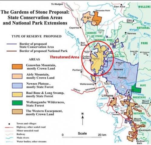 [Source: ^http://www.bluemountains.org.au/gos2.shtml] [Source: ^http://www.bluemountains.org.au/gos2.shtml]
‘These unprotected areas are just as valuable as the existing park, and are rich in special environments such as pagodas and canyons, nationally endangered high altitude shrub swamps and an unusual heathland on Genowlan Mountain. Rare and threatened species include the beautiful yellow Pagoda Daisy, Deane’s Boronia, Blue Mountains Water Skink, Wolgan Snow Gum, Giant Dragonfly, Regent Honeyeater, Genowlan Pea and Beautiful Firetail. In the western parts of the area the moist mountain vegetation begins to give way to drier inland communities, including grassy box woodlands, one of the most diminished and threatened environments in Australia.
‘The Gardens of Stone Stage 2 provides one of the most beautiful displays of sandstone geodiversity in Australia, comprising dramatically coloured sandstone escarpments and promontories, narrow canyons, cave overhangs, swamps and the complex arrays of rock pinnacles known as pagodas. The area has one of the Blue Mountains’ areas of highest plant diversity including ancient windswept montane heathlands, nationally endangered upland swamps, a unique species of snowgum (E. gregsoniana) and other high plateau woodlands representing the highest development of native vegetation on Sydney Basin sedimentary rocks, poorly conserved grassy white box woodlands on slopes below the sandstone, fascinating oil shale mining ruins on spectacular Airly Mesa, and outstanding Aboriginal cultural sites on and around Newnes Plateau.
") Gardens of Stone
© Photo by Hamilton Lund, Tourism NSW
Blue Mountains – Visit NSW, ^http://www.visitnsw.com/destinations/blue-mountains (click photo to enlarge) Gardens of Stone
© Photo by Hamilton Lund, Tourism NSW
Blue Mountains – Visit NSW, ^http://www.visitnsw.com/destinations/blue-mountains (click photo to enlarge)
.
The area embraces the last unprotected part of the 1934 Greater Blue Mountains National Park proposal compiled by Myles Dunphy for the National Parks and Primitive Areas Council. It also includes the Blue Mountains Western Escarpment lands from Blackheath to Lithgow. The Gardens of Stone Stage 2 proposal advanced by The Colong Foundation for Wilderness, the Blue Mountains Conservation Society and the Colo Committee is to include all of the remaining parts of Newnes Plateau and surrounding sandstone uplands – an area of 40,000 hectares. It would protect the most spectacular pagoda landscapes in Australia.
Associated with these pagoda landforms are found large caves, mazes, ancient montane heathlands, endangered upland swamps, snowgums, grassy woodlands and moist gullies that contain tree ferns, stands of old growth forest and rainforest, and, in some places, slot canyons.
Reservation of Stage Two would also secure the outstanding ochre coloured cliffs of the Blue Mountains’ Western Escarpment and the rare plant communities that lie above them. Reservation of the remaining unprotected parts of the Gardens of Stone as a State Conservation Area is urgently required to rein in ongoing and accelerating environmental degradation.
[Sources: Gardens of Stone National Park, http://www.worldheritage.org.au/resources/national-parks/gardens-of-stone-national-park/ and Blue Mountains Conservation Society, http://www.bluemountains.org.au/gos2.shtml]
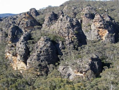 Pagodas of the Gardens of Stone (still outside the National Park) Pagodas of the Gardens of Stone (still outside the National Park)
© Photo by Andrew Valja
[Source: Blue Mountains Conservation Society, http://www.bluemountains.org.au/gos2.shtml]
(click photo to enlarge)
.
.
.

Threats from Coalpac Pty Ltd
.
CoalPac is a private Queensland coal mining company headquartered in Pullenvale in outer eastern Brisbane. In 1989, CoalPac took over coal mining operations outside the town of Lithgow in New South Wales, at the Cullen Valley Open Cut Mine and the Invincible Open Cut Mine. The Mines currently operate at 2 mtpa and Coalpac has plans for significant expansion of coal mines in the Gardens of Stone area.
 Coalpac’s CullenValley Mine
[Source: Lithgow Environment Group, Inc.]
(click photo to enlarge) Coalpac’s CullenValley Mine
[Source: Lithgow Environment Group, Inc.]
(click photo to enlarge)
.
‘Coalpac is seeking approval for the consolidation and expansion of the existing Cullen Valley Mine and Invincible Colliery operations to produce up to a total of 3.5 million tonnes per annum.’ [Source: http://cetresources.com/about-us]
This proposed extension of its open-cut and highwall mining will intrude into a large area of the publicly-owned Ben Bullen State Forest (BBSF), NSW. The extension area is equivalent of 2,176 football fields of predominantly old growth forest will be clear-felled and excavated if this goes ahead. The pagoda’s features and stability may be threatened by collapse.
 Cracked Hassans Walls, Lithgow ~ caused by nearby mining
[Source: Lithgow Environment Group, Inc.] Cracked Hassans Walls, Lithgow ~ caused by nearby mining
[Source: Lithgow Environment Group, Inc.]
.
“The NSW National Parks and Wildlife Service (now within the Office of Environment and Heritage) has acknowledged its wish to add BBSF to the conservation reserve system as a matter of priority” says Lachlan Garland, President of the Blue Mountains Conservation Society.
“Allowing this operation would mean the equivalent of 2,176 football fields of predominantly old growth forest of the BBSF being clear-felled and excavated.
“This forest is a publicly-owned area of conservation and recreational importance. The community expects state forests to be protected from destruction in perpetuity.
 ‘Baal Bone Creek’ area at risk
©Photo by Ian Brown.
‘Baal Bone and Long Swamp (7,800 hectares) comprise massed pagoda ‘villages’ above the Long Swamp, a diverse swampy plain. They collectively form an evocative landscape of broken stone, reminiscent of Cambodia’s forest of State Forest temples, while nearby indigenous cave art honours this landscape.’
(click to enlarge, then click again to enlarge further) ‘Baal Bone Creek’ area at risk
©Photo by Ian Brown.
‘Baal Bone and Long Swamp (7,800 hectares) comprise massed pagoda ‘villages’ above the Long Swamp, a diverse swampy plain. They collectively form an evocative landscape of broken stone, reminiscent of Cambodia’s forest of State Forest temples, while nearby indigenous cave art honours this landscape.’
(click to enlarge, then click again to enlarge further)
.
“Habitats for the Regent Honeyeater, Tiger Quoll and Powerful Owl and at least 32 threatened native animals, 5 of which are listed under the EPBC Act, will be completely removed.
“Our iconic Lyrebirds also use the sides of pagodas to nest and raise their young. Mining will completely remove the protective pathways for adult birds foraging between nesting sites and will destroy their food habitats within the more fertile valley floors.
“The effective privatisation and liquidation of a large part of the forest is an outrageous precedent that should not be set; it is a direct challenge to the state’s efforts to reduce deforestation.
“The Blue Mountains Conservation Society seeks to work with the Minister for the Environment and Heritage, Robyn Parker, to continue our important work and safeguard the future of the Gardens of Stone.
“We invite all politicians to visit the Gardens of Stone area with us on Sat 14th May, 2011 to see first hand the stunning areas under threat from mining.”
The NSW Department of Planning finalised the Director-General’s Requirements (guidelines) for the Environmental Assessment on 16 October 2010. The proponent is preparing the Environmental Assessment. Once finalised, this will be released for public comment. The project, prior to the election of the NSW Coalition Government, was to be assessed by an accredited process under Part 3A, which on 7th April 2011 was scrapped by the incoming O’Farrell Liberal Government of New South Wales. [read article below]
 The very yellow Pagoda Daisy (at risk)
©Photo by Ian Brown
(click to enlarge, then click again to enlarge further) The very yellow Pagoda Daisy (at risk)
©Photo by Ian Brown
(click to enlarge, then click again to enlarge further)
.
Environment groups take action to protect Gardens of Stone
The uniquely scenic and biodiverse Gardens of Stone is under imminent threat due to a consolidation proposal by Coalpac Pty Ltd. If approved, wildlife habitat and natural heritage will be lost forever, water systems will be stressed and there would be direct impacts for local residents. On Saturday 14th May, 2011 environment groups and their supporters will be taking action to help protect this iconic landscape from irredeemable destruction.
“Coalpac Pty Ltd seeks to extend open-cut and highwall mining into a large area of the publicly-owned Ben Bullen State Forest, NSW. The NSW National Parks and Wildlife Service has acknowledged its wish to add this forest to the conservation reserve system as a matter of priority” says Tara Cameron, Vice President of Blue Mountains Conservation Society.
“Many of the highwall scarps will abut strata directly below the ‘pagoda’ rock formations, their features and stability may be threatened by collapse. Environment groups are outraged at this proposal” says Tara Cameron.
“This forest is a publicly-owned area of conservation and recreational importance. The community expects state forests to be protected from destruction in perpetuity. If the NSW Government’s Strategic Regional Landuse Policy is to mean anything for sensitive, natural lands, then the Gardens of Stone must be protected from destructive mining operations, ” says Keith Muir, Director of Colong Foundation for Wilderness.
“This landscape is biodiversity hotspot, characterised by rich old-growth forests. Our iconic Lyrebirds use the sides of pagodas to nest and raise their young. Mining will completely remove their food habitats as well as the habitats of at least 32 threatened native animals” says Belinda Fairbrother, Campaigns Manager for The Wilderness Society NSW.
“Water management and impacts over such a large, exposed open-cut area are of great concern. The large open cut will also create significant dust and air quality issues which will impact directly on local residents” says Caroline Graham, Vice President of Rivers SoS.
“Environment groups are calling on the government to reject this mining proposal and act to protect the region within a State Conservation Area. We are coming together at this event to send a clear message that ‘We say No to open cut mining!’ in this iconic area of our state” says Kevin Evans, EO of National Parks Association of NSW.
“Across NSW, areas of high conservation value and great beauty are under threat from the rapid expansion of the coal and coal seam gas industries. During this time of transitional arrangements on the regulation of coal mining, the State government has an opportunity to deliver on its promise of better protection of water resources and the environment by rejecting further mining at the iconic Gardens of Stone,” says Pepe Clarke, CEO of the Nature Conservation Council of NSW.’
[Source: National Pars Association of NSW, http://www.npansw.org.au/index.php?option=com_content&view=article&id=718:environment-groups-take-action-to-protect-gardens-of-stone&catid=172:2011&Itemid=564]
.
.
‘Part 3A scrapped’
[8 Apr 11, by Tyron Butson, Southern Courier newspaper, http://southern-courier.whereilive.com.au/news/story/part-3a-scrapped/]
PREMIER Barry O’Farrell has given increased planning powers back to local councils after scrapping the controversial Part 3A amendment.
He announced the decision to drop Part 3A of the 1979 Environmental Planning and Assessment Act at yesterday’s first State Cabinet meeting.
Local councils will now have final say on many outstanding applications, while others will be referred to the NSW Planning Assessment Commission.
No new Part 3A application for residential, commercial, retail or coastal development will be accepted and the State Government hope to push through legislation that will see the amendment repealed from the Statute books when Parliament resumes.
“This means a return of planning powers to councils and local communities,” Mr O’Farrell said.
“The days of giving the Planning Minister sweeping powers to approve developments at the stroke of a pen with virtually no consultation with local communities are over.
“That extreme power only leads to the sort of suspicion and shady deals we have seen in NSW over the past 16 years.”
The scrapping of Part 3A was a core election promise of the Liberal party, but the government will still have to push legislation through the Upper House.
Mr O’Farrell said he had not attempted to convince opposition members but had directed the Minister for Planning Brad Hazzard to draw up plans.
Until then transitional arrangements will be put into place to deal with more than 500 Part 3A applications already in the system.
About half of the applications will now face the Planning Assessment Commission for assessment, while the rest will either be sent to local councils to vote on or allowed to lapse.
Part 3A was introduced in 2005 and gave planning ministers the ability to overrule local councils and communities on any project the minister deemed to be of state or regional importance.’
.
.
‘Cliffs crumbled due to coal mining, says new report’
(by Ben Cubby, Environment Editor, Sydney Morning Herald, April 27, 2010)
‘DOZENS of cliffs have crumbled or collapsed, Aboriginal rock art has been destroyed and metre-wide cracks opened in the earth as a result of coalmining in the Gardens of Stone wilderness area near Lithgow, an independent report has found.
The damage, inflicted over three decades by five coal mines and continuing today, is caused by subsidence from longwall mining, which now almost surrounds the Gardens of Stone National Park, part of the Greater Blue Mountains World Heritage Site. It is likely to be extended further if a new mine plan is approved by the NSW government.
The report, to be launched today by the former premier Bob Carr, documents wide-scale, unpublicised damage, including the destruction of some of the area’s unique sandstone pagodas and rock arches.
”In its monitoring reports to government, the coal industry regularly understates the damage caused,” said Keith Muir, the executive officer of the Colong Foundation for Wilderness, which produced the report. ”Mine operations do not work to minimise environmental damage and have been largely unresponsive to environmental concerns.”
The study based this conclusion on visual observation in the remote bushland and examination of the the environmental assessments used to justify the expansion of mining. In some cases, the assessments predicted that cliffs could crumble but no remedial action was taken.
The report looks at the six coalmines around the national park: the Angus Place, Springvale and Airly mines operated by Centennial Coal, Baal Bone and Clarence collieries operated by Coalex, and Invincible mine, operated by Coalpac. All the mining companies have met the requirements of their environmental assessment processes and have continued to monitor the impact of subsidence.
Reports produced by consultants employed by the companies showed more than 100 recorded cliff falls in the past three decades. Some led to changes in sites and techniques, but in the majority of cases the warnings were not heeded.
The damage was significantly worse above longwall mines, which cut out long, broad panels of coal, leaving the surface above to crack and subside. The Clarence and Airly mines use the bord and pillar technique, which involves leaving more coal in the ground to support the rock above, resulting in less surface damage.
Aboriginal rock art sites were also photographed with major fractures running through them and, in some cases, entire rock faces destroyed by the effects of subsidence.
”Crevasses, cliff falls and rock fractures are spoiling the sandstone beauty of the Gardens of Stone,” Mr Muir said.
The organisation is calling for a state-sanctioned conservation area that would provide a buffer zone around the park. It would cover part of the Baal Bone mine area, where a further expansion is planned, and the Newnes Plateau, where many swamps have been drained when the rock beneath them cracked open.
”The Department of Environment, Climate Change and Water has been considering proposals for additions to the Gardens of Stone National Park and an evaluation process is under way,” a spokeswoman said.
Read more: http://www.smh.com.au/environment/cliffs-crumbled-due-to-coalmining-says-new-report-20100426-tnbk.html#ixzz1MGS62mRx
.
.
Previously in 2007…

.
.
Further Reading:
.
[1] Previous article on this website: ‘Gardens of Stone at Risk from Coal Mining’, > https://www.habitatadvocate.com.au/?p=4021
[2] Blue Mountains Conservation Society, ^http://www.bluemountains.org.au/gos2.shtml
[3] Gardens of Stone National Park, ^http://www.worldheritage.org.au/resources/national-parks/gardens-of-stone-national-park/
[4] The Colong Foundation for Wilderness, ^ http://www.colongwilderness.org.au/Gardens_of_Stone/GoS2_home.htm
[5] Lithgow Environment Group, Inc. ^http://www.lithgowenvironment.org/mine_watch.html
[6] Lithgow Tourism, ^http://www.lithgow-tourism.com/gardenstone.htm
[7] Rivers SOS, ^http://riverssos.org.au/2011/04/27/help-us-protect-the-gardens-of-stone/
[8] National Parks Association of NSW, ^http://www.npansw.org.au/index.php?option=com_content&view=article&id=718:environment-groups-take-action-to-protect-gardens-of-stone&catid=172:2011&Itemid=564
[9] ‘Cliffs crumbled due to coalmining, says new report’, by Ben Cubby, Sydney Moring Herald, April 27, 2010, ^http://www.smh.com.au/environment/cliffs-crumbled-due-to-coalmining-says-new-report-20100426-tnbk.html

– end of article –
Environment groups take action to protect Gardens of Stone
The uniquely scenic and biodiverse Gardens of Stone is under imminent threat due to a consolidation proposal by Coalpac Pty Ltd. If approved, wildlife habitat and natural heritage will be lost forever, water systems will be stressed and there would be direct impacts for local residents. On Saturday 14th May, 2011 environment groups and their supporters will be taking action to help protect this iconic landscape from irredeemable destruction.
“Coalpac Pty Ltd seeks to extend open-cut and highwall mining into a large area of the publicly-owned Ben Bullen State Forest, NSW. The NSW National Parks and Wildlife Service has acknowledged its wish to add this forest to the conservation reserve system as a matter of priority” says Tara Cameron, Vice President of Blue Mountains Conservation Society.
“Many of the highwall scarps will abut strata directly below the ‘pagoda’ rock formations, their features and stability may be threatened by collapse. Environment groups are outraged at this proposal” says Tara Cameron.
“This forest is a publicly-owned area of conservation and recreational importance. The community expects state forests to be protected from destruction in perpetuity. If the NSW Government’s Strategic Regional Landuse Policy is to mean anything for sensitive, natural lands, then the Gardens of Stone must be protected from destructive mining operations, ” says Keith Muir, Director of Colong Foundation for Wilderness.
“This landscape is biodiversity hotspot, characterised by rich old-growth forests. Our iconic Lyrebirds use the sides of pagodas to nest and raise their young. Mining will completely remove their food habitats as well as the habitats of at least 32 threatened native animals” says Belinda Fairbrother, Campaigns Manager for The Wilderness Society NSW.
“Water management and impacts over such a large, exposed open-cut area are of great concern. The large open cut will also create significant dust and air quality issues which will impact directly on local residents” says Caroline Graham, Vice President of Rivers SoS.
“Environment groups are calling on the government to reject this mining proposal and act to protect the region within a State Conservation Area. We are coming together at this event to send a clear message that ‘We say No to open cut mining!’ in this iconic area of our state” says Kevin Evans, EO of National Parks Association of NSW.
“Across NSW, areas of high conservation value and great beauty are under threat from the rapid expansion of the coal and coal seam gas industries. During this time of transitional arrangements on the regulation of coal mining, the State government has an opportunity to deliver on its promise of better protection of water resources and the environment by rejecting further mining at the iconic Gardens of Stone,” says Pepe Clarke, CEO of the Nature Conservation Council of NSW.
Tags: Baal Bone, Barry O'Farrell, Ben Bullen State Forest, Blue Mountains World Heritage Area, Capertee Valley, Coal Mining, Coalpac Pty Ltd, Gardens of Stone, Genowlan Mountain, Hassans Walls, Lithgow Coal, Minister for Planning Brad Hazzard, Minister for the Environment and Heritage Robyn Parker, Newnes Plateau, Pantoneys Crown, Part 3A, Powerful Owl, Regent Honeyeater, Tiger Quoll, Wolgan Valley
Posted in Blue Mountains (AU), Threats from Mining | No Comments »
Add this post to Del.icio.us - Digg
Wednesday, January 26th, 2011
") Capetree Valley looking toward Pentoney’s Crown,
Gardens of Stone NP
Blue Mountains region, New South Wales, Australia
© Photo by Henry Gold, wilderness photographer Capetree Valley looking toward Pentoney’s Crown,
Gardens of Stone NP
Blue Mountains region, New South Wales, Australia
© Photo by Henry Gold, wilderness photographer
.
Gardens of Stone is a national park in the Australian state of New South Wales, 125 km northwest of Sydney. At 15,010 ha it is part of the Greater Blue Mountains Area World Heritage Site. [Wikipedia]

.
Yet much larger and similarly high conservation areas featuring pagodas of the Gardens of Stone and other incredibly rare natural landscapes and ecosystems lie adjacent to this national park. Similar rugged natural areas adjoining the Gardens of Stone National Park span some additional 40,000 hectares, featuring rare and magnificent sandstone escarpments, ancient natural pagodas and plateau country of the north western Blue Mountains – a natural part of the declared Greater Blue Mountains World heritage area park system.
Read below to learn more about proposed protection ‘Stage Two’ …
.
.
The Gardens of Stone Park Proposal Stage Two
.
Joint Media Release 28 November, 2005 by Colong Foundation for Wilderness, Blue Mountains Conservation Society and the Colo Committee:
.
‘Today the Colong Foundation for Wilderness, the Blue Mountains Conservation Society and the Colo Committee launched a new proposal to protect 40,000 hectares. The proposal, centred on the township of Lithgow, is called the Gardens of Stone.
“The Gardens of Stone area is scenically, environmentally and historically unparalleled. Its current low level of protection shows a scandalous disregard of this magnificent heritage. The Gardens of Stone proposal is an innovative approach that will ensure better protection of these unparalleled areas and greatly enhance tourism in the western Blue Mountains-Lithgow region”, said Dr Brian Marshal, President of the Blue Mountains Conservation Society.
“’This area for too long has been taken for granted, yet is truly a national gem. Its geology is dramatic and spectacular, its biodiverisity is fascinatingly diverse, and its cultural history is extensive. It is time at last for the overlooked to be valued and acknowledged. This is a fantastic area that truly deserves reserve status!”, said Haydn Washington, Secretary of the Colo Committee.
“The Gardens of Stone is a place worth saving that has great potential for quiet, family-based recreation. The proposed system of new Gardens of Stone parks will greatly enhance tourism opportunities in the central and western Blue Mountains around Lithgow,” said Keith Muir, director of the Colong Foundation for Wilderness.
The Gardens of Stone has iconic heritage of national significance. The park proposal aims to protect and manage:
- the first three rugged mountain passes west to the interior of Australia;
- the outstanding Aboriginal cultural sites on and around Newnes Plateau;
- the wonderful oil shale mining ruins on spectacular Airly Mesa;
- some of the highest plant diversity in the Blue Mountains; and
- some of the most beautiful and intricate sandstone formations in Australia.
.
“The plant, animal and Aboriginal heritage of the proposal reflect the landscape’s diversity. The proposal’s many rare plants, unique snowgrass-snowgum woodlands, shrub swamps and heathlands are not protected elsewhere, said Mr Washington.
“The Gardens of Stone is a geological wonderland of coloured escarpments, narrow canyons, rock arches, cave overhangs, lonely sandstone peninsulas and remnant forested sand dunes from the last ice age”, Dr Marshall said.
Mr Muir believes that “Heritage-based tourism could draw Lithgow toward a more environmentally sustainable future”.
“The proposal provides an integrated plan of action to protect, manage and interpret the area but recognises the realities of existing coalmining operations”, he added.
[Source: http://www.colongwilderness.org.au/media_releases/media_archive05.htm#MR05112800]
.
.
The following article is that by Ian Brown of the Colong Foundation for Wilderness which may be located under the heading ‘Seeing the Gardens by Ian Brown.’ It is based upon a report on the recreational and tourism potential of the Gardens of Stone Stage 2 park proposal, jointly commissioned by the Blue Mountains Conservation Society and the Colong Foundation.)
.
‘The Gardens of Stone Park Proposal Stage Two (GoS2) was launched by the Colong Foundation in 2005. It covers an area of 40 000 hectares of sandstone escarpment and plateau in the western Blue Mountains , on the western side of the existing Greater Blue Mountains World heritage area park system. The proposal takes in parts of the upper Capertee Valley , Coxs River headwaters, Turon River headwaters, Newnes Plateau and Blue Mountains western escarpment.
The objective of the GoS2 proposal is to achieve better management and protection of this area’s many important natural and cultural values. The GoS2 park system is proposed to be a mixture of state conservation area (SCA) and national park tenure. SCA status allows underground coal mining to continue.
The GoS2 area’s outstanding conservation values have been well documented in the Colong Foundation’s The Gardens of Stone Park Proposal Stage Two (October 2005). There is no doubt that the area’s scenery and heritage can also offer a diverse range of low impact recreational activities attracting significant visitor numbers, thus expanding the local tourism industry. One purpose of the current study was to show that GoS2 can deliver significant economic benefits to local communities.
.
An under-valued landscape
.
‘GoS2 offers the part of the Gardens of Stone landscape that is easily accessed and enjoyed by the general public. The nearby parks offer similar features and experiences, but they tend to be accessible to visitors with bush skills due to more rugged topography. GoS2, which is largely of more subdued terrain, brings the unique landscape of the Gardens of Stone to the majority of people.
This article will focus on the northern sectors that make up most of the proposal and which have the greatest potential for improved conservation and recreation management. These include the Airly-Genowlan mesas and Ben Bullen, Wolgan and Newnes State Forests. The other main sector, the western escarpment Crown reserves extending from Hassans Walls at Lithgow to Medlow Bath, is already well developed for recreation with increasingly effective management by local councils.
But the existing management regime over Airly-Genowlan and the state forests can best be characterised as lassez faire in relation to recreation and relatively passive in relation to conservation. The dominant land uses of coal mining and forestry have led to a devaluation of the important natural and cultural heritage values of the area in the public mind. Off-road vehicle activity, particularly trail bike riding, has been allowed by neglect to become the dominant recreation, even though most of it is illegal (unregistered vehicles, unlicensed riders and creating new tracks). This has further alienated less damaging activities such as walking, which mainly takes place on the fringes of the plateaus.
The GoS2 area has not yet been presented or promoted to the public as a great place to enjoy a remarkable landscape. Hence, the strong potential of the GoS2 area for low-impact, nature-based recreation and tourism has been under recognised and under-utilised.”
.
A better future
.
‘This can be changed by implementing the GoS2 reserve proposal and advancing a recreation and tourism plan for the area. With the right presentation and promotion, environmentally benign recreational use of GoS2 can be expanded dramatically.The natural and cultural attractions are many, varied, widespread across the area and highly appealing. Some features (e.g. Lost City , Carne Creek gorge, new Hartley mining heritage, Wolgan Valley Rail Trail) have the potential to become iconic attractions. A number of easy wildlife viewing opportunities exist and several Aboriginal heritage experiences are available.
This alternative vision presents an existing network of touring routes for motor vehicles and bicycles, accessing a range of potential camping areas, bushwalks, lookouts and cultural and wildlife experiences. Most of the proposed places of interest can be linked into a ‘Gardens of Stone Grand Tour’ which could be taken over one to three days by 4WD vehicle or mountain bike.
Although providing for these recreational activities will have some localised impacts, a number of already-disturbed sites can be utilised. Furthermore, the likely impacts are minor when compared to the existing and future impacts of the current recreational regime.
The current controversy over government plans to expand private tourism development within national parks has been taken into account, and the GoS2 plan seeks to demonstrate how low-key, low impact visitor facilities can provide the backbone of local tourism without damaging the parks with accommodation and similar developments.
The proposed network of visitor experiences would provide the basis of a whole new nature-based marketing initiative for the western Blue Mountains, promoting the Gardens of Stone as the very distinctive other side of the Blue Mountains. Just two hours from Sydney and with all the services any visitor could need in adjacent towns, GoS2 could become an iconic venue for campers, bushwalkers, tourers, cyclists and nature and heritage enthusiasts. The suite of opportunities creates a sound basis for commercial tourism enterprises such as guided tours and local off-park accommodation.
Such a future could realise significant economic opportunities through visitor expenditure, and for both specialised services (tours, eco-accommodation) and more general commercial activity in the surrounding area.”
.
Economic benefits
.
Estimating tourism to protected areas and resultant economic benefits can be difficult. Based on comparable statistics and studies from NSW, Queensland and Victoria, a conservative upper estimate for tourism to a GoS2 park with the proposed facilities is 50,000 visitors a year. This level of tourism activity has been estimated to produce substantial net benefits to the community in the order of $28M to $38M, depending on the discount rate used. These net benefits may represent a minimum value since management costs savings to Forests NSW have not been able to be included and the levels of timber production and royalties assumed may be conservatively high.The regional economic benefit produced by 50,000 visitors to GoS2 is estimated as a direct spend of around $3M to $4M. Over and above this would be expenditure on park management, and the expansion of commercial tour activities and the establishment of new visitor accommodation in nearby areas which is likely to follow.
The case for protecting the GoS2 lands for both conservation and direct community benefit is strong. It is now up to the NSW Government to do it.’
.
[Source: http://www.colongwilderness.org.au/features.htm]
.
.
But the Gardens of Stone are being destroyed by Centennial Coal
.
The magnificent rugged and rare geomorphology and high plateau ecosystems of the Bkue Mountains region is under serious irreverible threat of destruction by coal mining. The natural heritage values of the Gardens of Stone are being impacted by coal mining, causing bedrock subsidence, longwall mining is cracking the creekbeds and mine effluent pumping are destroying the natural groundwater acquifers. The rare geodiversity is being destroyed as Centennial Coal’s mining at Angus Place Colliery and Baal Bone Colliery cause cliff falls.
Aboriginal heritage rock art is being fractured. Creeks, rivers and upland swamps such as East Wolgan Swamp are being polluted by heavy metals from Centennial Coal’s mines. The mining is causing surface subsidence, stream flows are disappearing in Kangaroo Creek and the Wolgan River
A media release by the Colong Foundation for Wilderness 27 April 2010, highlighted current threats posed by Coal Mining:
The Gardens of Stone – a story to break the hardest heart
‘Imagine, New South Wales has its very own Bungle Bungle Range just 2½ hours from Sydney on the western edge of the Blue Mountains. It is a place of superlative scenery and tremendous botanical diversity. Today the Colong Foundation reveals that this little known wonderland called the Gardens of Stone may soon be spoiled if high impact coal mining is not curbed..“The Colong Foundation’s recent report (The impact of coal mining on the Gardens of Stone) documents how the coal industry’s environmental record is being etched and caved onto the Gardens of Stone landscape,” said Keith Muir Director of the Colong Foundation for Wilderness.
“Coal mining has:
- Caused several hundred cliff collapses in the most beautiful part of the Blue Mountains;
- Monitored these cliffs falls for 30 years, rather than acted to reduce the damage;
- Turned (nationally endangered) swamps to dust by cracking near-surface aquifers;
- Poisoned (nationally endangered) swamps with eco-toxic mine effluent;
- Turned the Wolgan River red;
- Claimed an environmental award for providing dirty, saline mine effluent to a power plant that shortly afterwards required a major repairs to its condensers costing tens of millions of dollars;
- Blighted the landscape with a network of roads, pipes, survey lines and power lines;
- Polluted drinking water supplies for Lithgow with nickel.
.The list goes on”, Mr Muir said.“In its monitoring reports to government the coal industry regularly understate the damage caused,” he said. “Mine operations do not work minimise environmental damage and have been largely unresponsive to environmental concerns”, he added.
“Crevasses, cliff falls and rock fractures are spoiling the sandstone beauty of the Gardens of Stone. Yet despite the intense study of mine subsidence for 30 years, the natural geomorphological processes that control cliff falls are not understood”, said Mr Muir.
“The Gardens of Stone in NSW is as spectacular as the Bungle Bungle Ranges, with a far greater floristic diversity. It must not be needlessly degraded by coal mining, as it can be preserved for everyone to enjoy,” Mr Muir said.
The damage can be curbed by reducing mining intensity. Taking such action would actually employ more miners and save this outstanding environment. One colliery has reduced its mining intensity, and a new one is about to start that will be far less damaging than previous operations. The State and Federal Governments should step in to protect from further damage the nationally endangered shrub swamps, the streams, cliffs and the sandstone pinnacles called pagodas that make up this natural wonderland”, Mr Muir said.
.
.
.
New mining prospect for Capertee
[Article from the local newspaper, The Lithgow Mercury, 20080705]
.

‘The Capertee community could benefit from a significant economic boost in the near future, including the direct creation of 80 jobs, if Centennial Coal’s Airly Project proceeds. Airly is an 80 million tonne coal resource located approximately 3 km north east of the Capertee township and is a project acquired by Centennial Coal in 1997 with an existing planning consent (originally granted in 1993).
There had been previous activity on the site including underground mining to obtain a bulk sample and verify mining conditions. Further work required to establish a trial mine commenced in April 1998. A Trial Mine Phase commenced in December 1998 when about 70,000 tonnes of coal was extracted over a 12 month period. An access road and other surface works were also completed.
“Lately, locals will have noticed an increase in traffic movement around Airly as a variety of visitors to the site complete studies, update data and review planning and engineering options for the site,” Centennial’s General Manager: Projects, Richard Tacon said.
“The proposed mine design would include the construction of a rail loading facility to ensure all coal from the site can be transported by rail.
“We anticipate the internal assessment process will be finalised over the next few months placing Centennial in a position to formalise a decision to proceed with the project,” Mr Tacon said.
“If Centennial does decide to proceed with this project, we will inform the community, place an utmost priority on minimising environmental impacts and strictly comply with the appropriate planning laws.”
[Source: http://www.lithgowmercury.com.au/news/local/news/general/new-mining-prospect-for-capertee/804919.aspx ]
.
.
.
Wolgan Road Project
.
On Centennial Coal’s website, under ‘Operations’ there is mention of a proposed Wolgan Road Project to be located within the Angus Place Colliery Lease. The project area is approximately 14km northwest of Lithgow, approximately 5km to the east of Mount Piper Power Station and 4km north of Wallerawang Power Station.
The area contains a small shallow coal resource between the underground workings of Wallerawang and Angus Place, with an estimated mine reserve of approximately 4.9 million tonnes, recoverable by open cut methods. Further detailed work including geotechnical investigations, environmental management assessment, community consultation and detailed mine planning would need to be completed before the requisite approvals could be sought.
[Source: http://www.centennialcoal.com.au/index.php?option=com_content&view=article&id=46&Itemid=54, accessed 20110126]
Sounds inoccuous enough, except that the Angus Place Colliery Lease is not ‘north west‘, but north of Lithgow. This places it within the Wolgan River catchment in sensitive escarpment country within the proposed Gardens of Stone NP Stage Two.
 Map from the 2008 NSW Coal Industry Profile.
. Map from the 2008 NSW Coal Industry Profile.
.
.
Centennial Coal’s Environmental Claims
.
Centennial Coal on its website under the heading of ‘Environmental Management‘ claims that Centennial’s Directors and Management are:
“committed to continual improvement in environmental and community management and performance.”
Centennial recognises the importance of effectively managing the environmental impacts associated with each mine and, over the years, has developed an Environmental Policy that commits the Company to continual improvement in its environmental management and performance.
 ‘Impact of Coal Mining on the Gardens of Stone’
©2010 Colong Foundation for Wilderness ‘Impact of Coal Mining on the Gardens of Stone’
©2010 Colong Foundation for Wilderness
.
CENTENNIAL COAL’S VISION
“To conduct our business in an efficient and environmentally responsible manner, that is compatible with the expectations of our Shareholders, government, employees and the community.”
 ‘Impact of Coal Mining on the Gardens of Stone’
©2010 Colong Foundation for Wilderness
.
. ‘Impact of Coal Mining on the Gardens of Stone’
©2010 Colong Foundation for Wilderness
.
.
CENTENNIAL COAL’S GUIDING PRINCIPLES FOR ENVIRONMENTAL MANAGEMENT
.
1. Appropriate decisions are made
2. Risk management strategies are implemented based on clear science and valid data
3. Stakeholders are identified and respected
4. Environmental impacts are recognised and minimised
5. Legal obligations are known and respected
6. Environmental management is integrated into our business
7. Environmental performance is continually improved
8. Natural resources are used efficiently
9. Performance is assessed and reported
 ‘Impact of Coal Mining on the Gardens of Stone’
©2010 Colong Foundation for Wilderness
.
. ‘Impact of Coal Mining on the Gardens of Stone’
©2010 Colong Foundation for Wilderness
.
.
The Centennial Environmental Vision and logo designed to assist in raising the awareness and visibility of the group’s environmental effort, seeks to deliver two messages:
- Firstly, that the environment matters to Centennial, ie it is a fundamental part of Centennial’s business; and
- Secondly, environmental matters, or elements of the biophysical environment (air, plants and animals, ground/soil and water) that sustain society can be affected by Centennial’s activities if not appropriately managed

‘In a “branding” sense, the motto ” environment matters” is designed to be a distinctive reminder of Centennial’s aims and commitments.’
[Source: http://www.centennialcoal.com.au/index.php?option=com_content&view=article&id=4:environmental-management&catid=10:who-we-are&Itemid=12]
Such is this company’s calculated greenwashing
to the extent of strategic misinformation,
so long as it exploits,
scams impunity from its heavy metal contamination,
inflicts irreversible bedrock subsidence….
Somehow justified by
‘temporary jobs, temporary jobs, temporary jobs’.
.
 …an ethical investment?
.
…an ethical investment?
.

.
Further Reading:
.
[1] Gardens Of Stone Stage 2 Proposal, ^http://bluemountains.org.au/gos2.shtml
.
[2] The Impact of Coal Mining on the Gardens of Stone [ read full publication],
http://www.colongfoundation.org.au
.
[3] Gardens of Stone National Park – Draft Plan of Management [ read full publication]
http://www.environment.nsw.gov.au/resources/parks/PoMDraftGardensOfStoneNP.pdf
.
[end of article]
.
Tags: Airly mine, Airly-Genowlan mesas, Angus Place Colliery, Baal Bone Colliery, Banpu, Ben Bullen State Forest, Blue Mountains Conservation Society, Blue Mountains western escarpment, Blue Mountains World Heritage Area, Capertee Valley, Carne Creek Gorge, Centennial Coal, Centennial Coal’s Airly Project, Clarence Colliery, Coal Mining, Coalex Pty Ltd, Coalpac Pty Ltd, Colong Foundation for Wilderness, Coxs River headwaters, DECCW, Gardens of Stone, Gardens of Stone National Park, Gardens of Stone Park Proposal Stage Two, GoS2, Hassans Walls, Henry Gold, Kores Aust. Pty Ltd, Lost City, Newnes Plateau, SK Corporation Pty Ltd, Springvale Colliery, Sydney Catchment Authority, Turon River headwaters, Wolgan River pollution, Wolgan Valley Rail Trail
Posted in 07 Habitat Conservation!, Blue Mountains (AU), Threats from Mining | 1 Comment »
Add this post to Del.icio.us - Digg
|
|
")
") Known distribution of the Endangered Blue Mountains Water Skink
Known distribution of the Endangered Blue Mountains Water Skink Longwall Mining Consequences
Total Environment Centre, ^http://www.tec.org.au/component/docman/doc_view/201-longwall-rep07
Longwall Mining Consequences
Total Environment Centre, ^http://www.tec.org.au/component/docman/doc_view/201-longwall-rep07

")

")


")


")

")


")


