Council’s Frank Walford Park Plan of 1981
We have stumbled across another old local government plan for The Gully, adding to The Gully Collection of The Habitat Advocate.
This one dates back to 1980 in brief draft form and was published in 1981 by landholder Blue Mountains {city} Council (local council). We only have the first eight pages of the 1980 draft, but we have the entire 53-page document of the 1981 ‘Frank Walford Park – Plan of Management‘.
We are also aware of prior land use plans for this valley extending back after WWII in the mid-1950s to impose the racing car circuit; and even back to the 1870s, when the first private colonial landholder of the area, John Britty North, subdivided a ridgetop portion for the first tranch of profiteering housing development. Befitting his robber baron ego, North dubbed it ‘North’s Estate’.
We at The Habitat Advocate are actually situated on the old North’s Estate since 2001, as our later reasearch tought us. We chose to live here because it was old established residential and so not to cause more deforestation by buying a finge ‘bush block’. So we research this area where we live in order to better understand its history, stories and so to better appreciate its conservation values.
We embed on this webpage below the draft document extract entitled ‘Assessment of Frank Walford Park Katoomba – Land Suitability, Environmental Constraints, Management‘. It appears to be hand typed, in the days before computers.
We also embed below the subsequent ‘Frank Walford Park – Plan of Management‘ of 1981 by local council. Both documents are supplied in PDF format and are made available here to the public for printing and downloading. Both the draft extract and the final plan of management relate to what was/remains ‘community land’, so we have no qualms in reproducing them here and making them freely publicly available.
Both documents are instructive in that they prescribe land use planning for what is currently termed ‘The Gully’ (or ‘Gungaree’ in native Gundungurra) that have subsequently been reguritated by council with many reiterations and renamings ever since. Consistently, as has been local council’s form similarly for decades, that is solely about being seen to comply with New South Wales Government’s mandatory planning laws for community lands.
Yet equally consistently, local council has serial form in implementing little if any on-ground action in this creeek valley. Why? Simply because of the lack of political/bureacratic will, and council’s decided to not even apply for external funding to have any of its plans of management for rehabilitating ‘The Gully’ implemented – since its 1972 demise of the racetrack. It’s a classic case of persistent organisation cultural guilt that continues to be seeded across subsequent generations of politically swayed bureaucratic management and incoming councillors decade after decade. Council’s cultural hate toward The Gully is despicable.
The contents focuses on the natural environmental features of the then ‘Park’, its historical and existing (human) uses, proposed land uses and a management plan.

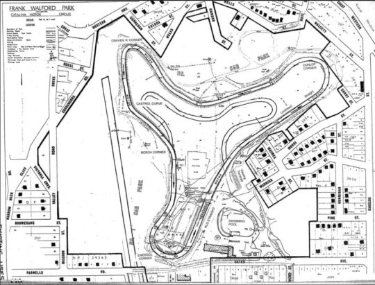
Frank Walford Park – Catalina Motor Circuit Map (circa 1980) showing the symetrical three-leafed shamrock shapped loop 1.3 miles in length. [SOURCE: Frank Walfors Park Managament Plan 1981, Blue Mountains {city} Council].
The above included street map shows hand written existing uses of the Park as approved by Council (utilising a good magnifying glass):
- Catalina Motor Racing Circuit
- Rally Cross Circuit (inside the circuit)
- BMX Track (inside the circuit)
- Three car parks (2 for spectators, 1 for competitors’ cars)
- Pit Area (inside the circuit)
- Four food stalls (outside the circuit) including the Apex Club food stall (top left)
- Three toilet blocks for spectators (outside the circuit)
- One toilet blocks for spectators (outside the circuit)
- One shower block for competitors (outside the circuit)
- Catalina Lake (for swimming)
- Indoor Recreation Centre (Council’s)
- Swimming Complex (outdoor pool)
- Bushfiire Shed (Rural Fire Service)
- An archery field
So at the time, the predominant appproach by Council to the use of the Park was for recreational and tourism use, less so environmental conservation and ecological rehabilitation.

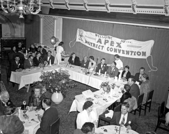
Note that the aforementioned ‘Apex Club food stall‘ at the motor racing circuit reveals key connection with the then Council Mayor Frank Walford. In 1956 Frank with his wife Madge were guests of honour at this fundraising Apex District Convention held at the then Katoomba Town Hall on nearby Parke Street situated on the ridgetop overlooking Frank Walford Park. Frank and Madge Walford are seen sitting at the head table (top left in this photo). [SOURCE: Blue Mountains Library – Local Studies, copyright licensing: Attribution, share alike, creative commons].
Frank Walford Park Management Plan of 1981
After Blue Mountains Mayor Frank Walford [1882-1969] passed away at age 80 years, Blue Mountains {city} councillors decided to name the creek valley after him as Frank Walford Park, probably sometime during the 1970s. Frank Walford had been a key supporter on council that approved a motor racing circuit to be constructed from 1957 in this small amphitheatre-shaped creek valley on the western fringe of the township of Katoomba.

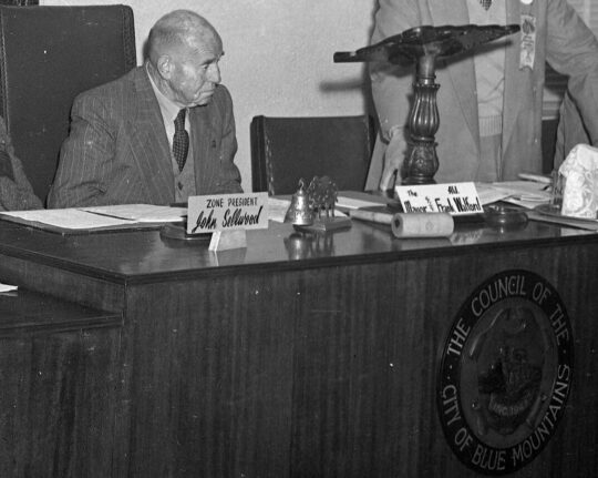
Mayor Frank Walford in 1956 (then aged 76) at a council meeting in the old Town Hall situated in Parke Street on the ridgetop just above the creek valley. The Town Hall was demolished in the 1960s and not replaced. Instead councillors voted to build a brutalist monolithic Council Chambers highrise building at a site isolated from the Katoomba business community.
Local residents who had lived in this small creek valley before 1957 had affectionately referred to it as ‘The Gully’. Council as the landowner of the valley, forcibly evicted all the local residents between 1957 and 1959, which involved council sending in a bulldozer to raze all their homes in order to make way for the new racetrack for a group fo locally influential and wealthy businessmen who were avid sportscar racing enthusiasts. Dubbed ‘Catalina Racetrack’ by council, the track operated between 1961 and 1971, after which the organisation running it went bankrupt.
By 1980, New South Wales Government planning laws required local councils throughout the state of New South Wales to periodically produce appropriate land use plans of management for community lands under their control, such as in the case of locl council, Frank Walford Park.
The draft extract of the 1980 plan would seem for the first time to start respecting the environmental values of this creek valley portion referred to by local council as Frank Walford Park. Local council’s draft assessment of Frank Walford Park is divided into two sections:
- Section 1: Reviewing the existing landscape, natural features, persent land use and historcial uses and :
- Section 2: Proposed land use development options
 Loading...


