July 11th, 2013
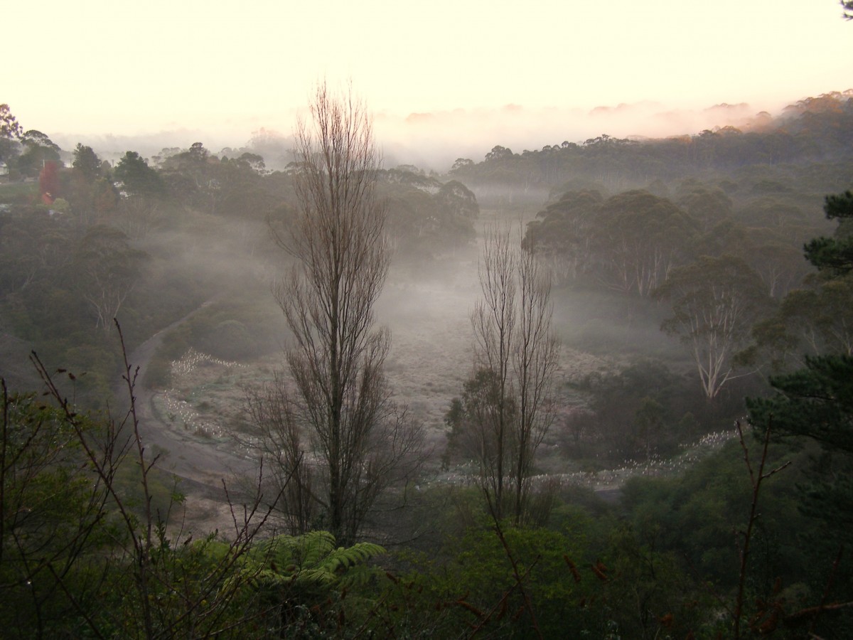 Frosty Morning in the Gully
[Photo by Editor, 20130711, Photo © under ^Creative Commons]
Click image to enlarge Frosty Morning in the Gully
[Photo by Editor, 20130711, Photo © under ^Creative Commons]
Click image to enlarge
.
Calling Me Home
.
<< I can feel the souls of my ancestors calling me back home
To all the familiar places and tracks I once did roam
I can see my Grandmother’s house at the end of Adams Street,
Where all the Aunties, Uncles and Cousins I did meet
To the banks of the Bokhara River running under the Richmond Bridge
You can hear the waters flow to the sound of an Elder’s didge
I can smell the boogalies cooking in a camp oven at my Aunty’s place
I can see the sun arising on the wrinkles of my Pop’s face
I can recall how my uncle taught me how to ride
In a paddock near their place with Robbo by my side
But I know I must stay here to get a good education
For I want to go back home after my graduation
To see the many family, friends and familiar faces I have known
I can feel the souls of my ancestors calling me back home
They’re calling me back, my ancestors in Mother Earth
I want to go back home, to the country of my birth. >>
.
[Source: ‘Calling Me Home’, by Lyndon Lane, Goodooga, NSW, in Koori Mail 507, p.23, ^http://www.creativespirits.info/aboriginalculture/arts/calling-me-home]
.
Leave a Reply
You must be logged in to post a comment.
July 10th, 2013
 They’re only Kangaroos
..Canberra just needs to expand, so it is easier to just get rid of the native kangaroos.
Katy Gallagher, ACT Chief Minister for Canberra and not much else. They’re only Kangaroos
..Canberra just needs to expand, so it is easier to just get rid of the native kangaroos.
Katy Gallagher, ACT Chief Minister for Canberra and not much else.
.
Katy’s blood lusting for another 2,000 Canberra Kangaroos
.
Katy Gallagher‘s ACT Government want to kill off thousands of pesky kangaroos so that Canberra can develop and expand its housing further into kangaroo feeding grounds.
<< The ACT Civil and Administrative Tribunal today has approved Gallagher’s government licences for kangaroos to be culled at seven sites around Canberra.
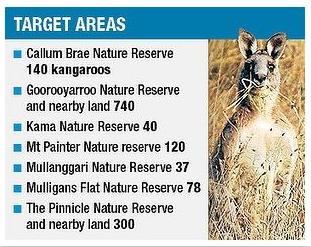
Appeal President Bill Stefaniak and Senior Members Allan Anforth and Adrian Davey varied some of the licences so that only 1244 kangaroos could be shot, not the 1455 originally approved the Conservator of Flora and Fauna. >>
.
[Ed: So Stefaniak has justified that 211 fewer kangaroos seems probably about right. Kill the rest?]
.
<< The seven reserves will be closed at Midday on Thursday to allow culling to take place before the end of July. Animal liberationists have vowed to try and disrupt the shooting of kangaroos in ACT nature reserves after a tribunal approved a scaled-back culling operation..
Carolyn Drew:
“Activists will protest at all seven sites but concentrate much of their efforts on the Goorooyarroo Nature Reserve where a licence has been granted for 740 kangaroos to be culled. We will focus on very intensely on that particular reserve. But the other reserves will also have teams of activists who sit around the various gates so we wait, watch and then we take action as needed.
Many more kangaroos than the 1,244 could die because the figure did not take into account small dependant animals that would be orphaned. “It’ll be within the range of closer to 2,000 that they’ll end up killing if they manage to kill that many.” 2,000 that they’ll end up killing if they manage to kill that many.”
.
The Australian Society for Kangaroos launched action in the tribunal in June to stop the cull.
The Tribunal accepted evidence from government ecologist Don Fletcher that an appropriate number of kangaroos per hectare was between 0.6 and 1.5, which The Government aimed to have one kangaroo per hectare. But the tribunal decided that the cull should aim to leave about 1.5 kangaroos per hectare.
The Australian Society for Kangaroos expert witness, Raymond Mjadwesch, had told the tribunal that it was ecologically appropriate for several more kangaroos per hectare to live on the reserves.

Mr Mjadwesch also challenged Dr Fletcher’s estimates of the number of kangaroos living in the reserves. But the tribunal preferred Dr Fletcher’s evidence over the evidence given by Mr Mjadwesch.
Outside the tribunal, ACT Parks and Conservation Service director Daniel Iglesias said as much of the cull would be completed as possible before a July 31 deadline.
“We originally had an eight week period and now we’ve only got a period of four weeks or so. So we will do our best to do what we can with the time that we have available to us,’’ Mr Iglesias said. Kangaroo culling only takes place in the ACT during the colder months to reduce the chances of younger animals being killed.
Fiona Corke, a former Neighbours star who is president of the Australian Society for Kangaroos, said she was disappointed the cull would go ahead. “We are disappointed that the cull will be proceeding but we are also encouraged by the fact that the tribunal has recognised that number of kangaroos should be and will be reduced,’’ she said.
Ms Corke declined to comment on whether her group would join protest efforts to disrupt the cull. >>
.
[Source: ‘Activists vow to disrupt shooting as roo cull approved by tribunal’, 20130710, by Peter Jean, Chief Assembly Reporter, The Canberra Times, ^http://www.canberratimes.com.au/act-news/activists-vow-to-disrupt-shooting-as-roo-cull-approved-by-tribunal-20130710-2ppeg.html]
.
.
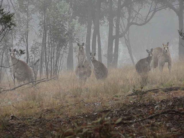 Eastern Grey Kangaroos were around Canberra before Canberra was thought of,
before developers profited from housing sprawl into kangaroo feeding grounds,
before the ACT government fenced them in so they overbred.
Now Katy Gallagher brands kangaroos not Native, but a pest,
just like British colonials treated Aborigines up until the ^1928 Coniston Massacre.
Eastern Grey Kangaroos were around Canberra before Canberra was thought of,
before developers profited from housing sprawl into kangaroo feeding grounds,
before the ACT government fenced them in so they overbred.
Now Katy Gallagher brands kangaroos not Native, but a pest,
just like British colonials treated Aborigines up until the ^1928 Coniston Massacre.
.
<< Known as the “Bush Capital”, Canberra has many nature reserves, but the present Legislative Assembly approved the slaughter – during June 2012 – of 2,000 kangaroos on these reserves.
Although the government-ordered slaughter has now ended for this year, the government fell short of its quota, with ‘only’ 1,154 killed, and has threatened to raise the quota for next season to make up for the shortfall.
However, the joeys aren’t counted in this number – as if they don’t ‘count’ or matter – so we’ll never know how many babies were murdered – by decapitation, bashed in heads – and other brutality – as the officially approved method. >>
.
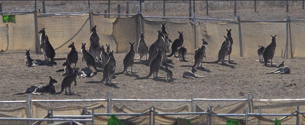
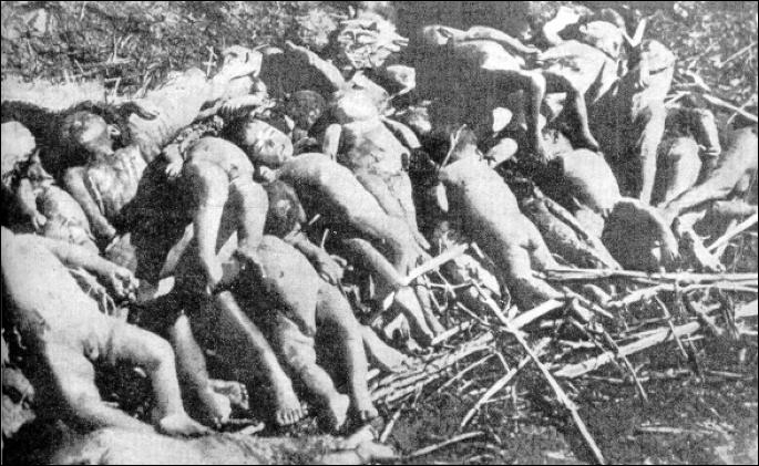
Monday May 19, 2008, government contractors started herding and slaughtering kangaroos on a former naval base in Canberra.
By May 29, 514 kangaroos were dead (including all in this photo).
[Source: Day Drew, Warning: this site contains images of animal suffering that may disturb some viewers.
^http://www.kangaroolives.com/]
.
I have several soul-destroying photos of the killing fields’ burial pits filled up with adult kangaroos and tiny joeys. The photos – including the one (below) – and the following description of events from those in the field were what drove me to start this petition.

<< “Unearthing the slaughter in Canberra, June 3rd: In the early hours of Sunday morning, activists uncovered a large mass burial pit at the Kama Nature reserve containing an estimated 300 or more slain kangaroo bodies.
Evidence was discovered amidst a slurry of mud and blood, illustrating unethical and illegal practices including throat shots, partially severed joeys and mature kangaroos with smashed heads. Amidst the twisted pile of discarded iconic Australians, a mature buck stands amongst his once proud mob – gunned down by faceless ignorance in Australia’s Capital.” >>
.

.[Source: ‘Stop the Slaughter of Kangaroos in Canberra’, 2013, a petition by Honour Leigh, ^http://www.change.org/en-AU/petitions/stop-the-slaughter-of-kangaroos-in-canberra]
.
Canberra’s 100 years of ecological slaughter to justify a ‘Bush Capital‘
.

.
2013: Katy Gallagher wants to slaughter 1,455 kangaroos this year in Canberra nature reserves
.
2012: Katy’s Cull included 407 joeys slaughtered
.
2009 – 2012, 3,000 kangaroos of Canberra were slaughered in various so-called ‘Nature Parks’.
.
[Source: ‘ACT kangaroos live another day’, ^http://www.al-act.org/]
.
Katy, wasn’t your 2011 massacre bad enough?
.
<<More than three thousand kangaroos will be shot over the next month as part of the ACT Territory’s annual cull, which starts tomorrow. ACT Parks and Conservation, which oversees the contractors conducting the cull, is this year targeting 3427 kangaroos on six sites in the Canberra Nature Park. The sites that will be closed to the public while the cull is underway are Mulligans Flat Nature Reserve, Goorooyaroo Nature Reserve, Mount Painter Nature Reserve, Callam Brae Nature Reserve, Jerrabomberra West Nature Reserve, Kama Nature Reserve and unleased territory land adjacent to Kama Nature Reserve.
ACT Parks and Conservation Service manager Daniel Iglesias said this morning that kangaroo numbers continued to rise despite the Government’s Kangaroo Management Plan culling program. “The cull of up to 3427 kangaroos is needed to maintain kangaroo populations at appropriate levels to protect the integrity of ecosystems, several of which contain endangered flora and fauna,” he said. “The numbers to be culled have been based on kangaroo counts in each location. “Ensuring the grasslands and woodlands are not overgrazed will protect threatened species and ecosystems, provide habitat for creatures such as ground-feeding birds, prevent excessive soil loss and maintain sustainable numbers of kangaroos.”
Mr Iglesias said the kangaroos would be humanely culled by experienced marksmen. “The cull will be conducted according to a strict Code of Practice that has the endorsement of all relevant authorities including the RSPCA. “Rangers and security staff have been engaged to patrol areas to ensure the safety of the public with warning signs also being installed at all entry points to the reserves,” he said. The ACT Government Vet would conduct spot checks during the program to ensure compliance with the relevant code of practice.>>
.
[Source: Canberra Times, ^http://www.kangaroo-protection-coalition.com/CanberraKangarooKill.html]
.
What about 2012, running out of kangaroo meat pet food?
.
 Wildlife Slaughter Sponsor Wildlife Slaughter Sponsor
.
<< More than 2,000 eastern grey kangaroos will be culled across nine reserves across the ACT over the next three weeks.
Nine nature reserves will be closed from Tuesday until June 12 to allow expert shooters to complete the cull. The reserves include Callum Brae, Crace, Goorooyaroo, Jerrabomberra, Kama, Mt Painter, Mulligans Flat, The Pinnacle and Wanniassa Hills.
Daniel Iglesias from Parks and Conservation says the high number of roos is damaging the environment.
“We’re fortunate in the ACT that we have really good quality natural environment so close to where we live,” he said. “So it’s a park service intention to manage kangaroo numbers so that they do not degrade their environment.”
The cull is part of the ACT Government’s Kangaroo Management Plan and will be conducted according to a strict code of practice endorsed by the RSPCA.
“We have gone out to almost all the areas in which we are going to cull and we have taken an estimate of the total numbers,” Mr Iglesias. “So in those nine areas that we are focusing on we’re looking at removing animals which may represent 10 – 15 per cent of the total population.” >>
.
 Wildlife Slaughter Sponsor Wildlife Slaughter Sponsor
.
[Source: ‘Canberra roo cull begins, parks closed’, 20120521, ^http://www.abc.net.au/news/2012-05-21/canberra-roo-cull-begins/4023910]
.
Ed: Sufficient power, means and justification can achieve anything one desires.
Anything!
.
 The Nankin Massacre of 300,000 unarmed Chinese men women and children by the Japanese military on December 13, 1937.
Because they were in the way of Japanese plans for economic expansion into Manchuria
It is a territorial thing.
What’s the moral difference Katy Gallagher? The Nankin Massacre of 300,000 unarmed Chinese men women and children by the Japanese military on December 13, 1937.
Because they were in the way of Japanese plans for economic expansion into Manchuria
It is a territorial thing.
What’s the moral difference Katy Gallagher?
.
Leave a Reply
You must be logged in to post a comment.
July 9th, 2013
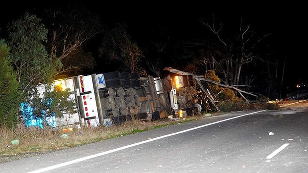 Another heavy linehaul truck crashes on another wide, fast, multi-laned highway
Truck drivers paid on a trip rate, not the safer hourly rate. Another heavy linehaul truck crashes on another wide, fast, multi-laned highway
Truck drivers paid on a trip rate, not the safer hourly rate.
.
Hume Highway at Marulan July 2013:
.
<< A man has died in a crash involving a truck and several cars on the Hume Highway, about 15km south of Marulan.
A NSW Police spokeswoman:
“The male driver of the semi-trailer was ejected from his vehicle and died at the scene. Emergency services responded to reports of a collision between a semi-trailer, a smaller truck and two cars in the southbound lanes of the Hume Highway” at 6.25pm (last night). The drivers of the other vehicles and their passengers were assessed by paramedics on site before being taken to Goulburn Base Hospital for further treatment.”
One southbound lane of the highway remained closed on Tuesday morning as traffic was directed around the crash site. >>
.
.
Hume Highway at Kyeamba Gap (same night):
.
<< Meanwhile, northbound lanes remain closed on the Hume Highway at Kyeamba Gap between Tumbarumba Road and Little Billabong Road following a truck accident there early this morning. >>
.
[Source: ‘One dead in Hume Highway crash’, 20130709, by Tom McIlroy and Stephanie Anderson, The Canberra Times, ^http://www.canberratimes.com.au/act-news/one-dead-in-hume-highway-crash-20130708-2pm8b.html]
.
.
Hume Highway at Marulan March 2012:
.
<< About 12.45am (Tuesday March 27, 2012) a B-double semi-trailer was travelling north laden with furniture , about 5km south of Marulan overnight.
The semi rolled onto its side spilling its load onto the highway, blocking all northbound lanes. A semi-trailer travelling behind the B-double truck crashed into the rear of the B-Double.
The driver of the B-double was taken to Goulburn Base Hospital suffering a possible fractured rib, while the driver of the second truck was not hurt. A salvage operation is underway following a double truck crash on the Hume Highway.
.
[Source: ‘Truck crash causes Hume Highway delays’, 20120326, The Yass Tribune, ^http://www.yasstribune.com.au/story/215489/truck-crash-causes-hume-highway-delays/]
.
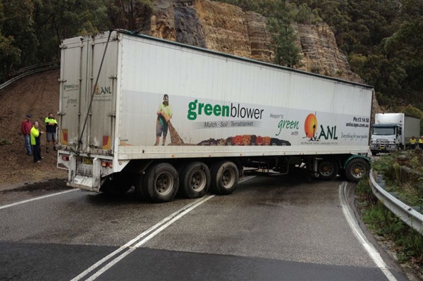 Australian Native Landscapes linehaul semi jack-knifes
One of many speeding over the B,ue Mountains
Truck drivers paid on a trip rate, not the safer hourly rate. Australian Native Landscapes linehaul semi jack-knifes
One of many speeding over the B,ue Mountains
Truck drivers paid on a trip rate, not the safer hourly rate.
.
<< Jack knifed … a truck accident shut the Great Western Highway at Mount Victoria this morning. The highway was shut for over an hour after a truck jack knifed blocking both lanes of the highway. A heavy tow truck was brought in to remove the truck. The road reopened around midday.
.
[Source: ‘Truck blocks Great Western Highway’, 20120418, ^http://www.westernadvocate.com.au/story/96085/truck-blocks-great-western-highway/]
.
.
Hume Highway at Marulan 29 July 2011
.
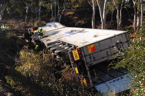 Australia Post (government-owned) StarTrack Express B-Double truck crashes off the Hume Highway
The overnight linehaul truck driver fell asleep on cruise control
Truck drivers paid on a trip rate, not the safer hourly rate.
[Photo: CHRIS GORDON] Australia Post (government-owned) StarTrack Express B-Double truck crashes off the Hume Highway
The overnight linehaul truck driver fell asleep on cruise control
Truck drivers paid on a trip rate, not the safer hourly rate.
[Photo: CHRIS GORDON]
.
<<The 47-year-old driver of this rig died when it ran off the Hume Highway near Marulan in the early hours of July 29. A report is being prepared for the coroner.
ROAD CLOSURE: The scene of Wednesday morning’s accident 500 metres south of Goulburn’s northern exit at 6am when for unknown reasons a B-double left the road. The driver suffered minor injuries.
With another two serious truck accidents on the Hume Highway near Goulburn in the past two weeks – one of them fatal – the Goulburn Post examines whether cruise control is a possible factor. LEIGH BOTTRELL reports.
IS cruise control on long-distance trucks – often allied with automatic transmission – contributing to serious accidents on our main highways?
This question increasingly is being raised as big semis and B-doubles proliferate and speed limits are increased on some major NSW country roads. Or, is boredom leading to drowsiness, brought on by modern “easy driving” truck technology and improved highways, the real culprit?
The jury is still out on this, while there is not yet definitive accident survey evidence pointing to cruise control’s role in accidents. But anecdotal evidence and practical knowledge of people long-associated with big rigs and their drivers suggests cruise-auto can be a mixed blessing.
Bert Cool has seen the aftermath of more truck accidents than probably anyone else in his 30 years with Royans, the Wagga Wagga-headquartered heavy vehicle recovery and repair group.
Now operating Australia-wide, Royans over the years have been called on to haul thousands of trucks back onto the road from every imaginable predicament. Too often, the smashed or burnt cabs tell the story of lives lost and families shattered.
And Bert Cool has no doubt that drivers falling asleep while their long-haul rigs are running on cruise control is a contributing factor to a growing number of highway accidents.
.
Bert Cool:
“Definitely. It happens more often now. A driver can nod off and the truck just keeps going, because he doesn’t have his foot on the accelerator. Before he wakes up, they’re in the scrub, or they hit something.
Before cruise control, if a driver dropped off at the wheel his foot nearly always fell away from the accelerator and the truck slowed down. He usually was woken up before they got into real trouble.”
.
However, Sergeant Rod Cranston, of Goulburn police highway patrol, doubts that cruise control by itself is a contributing factor to truck accidents.
.
[Source: ‘Cruise control, fatigue’, 20110811, by Leigh Bottrell, The Goulburn Post, ^http://www.goulburnpost.com.au/story/972063/cruise-control-fatigue/]
.
[Ed (ex-trucker): Overnight driving is inherently dangerous, and with trucks the risk is exacerbated. Linehaul (long-distance) freight should travel by rail for reasons of safety away from ordinary road users and economy of scale. Local distribution freight should travel BY DAY on the roads until governments can adequately safeguard local communities from the unacceptable risks and consequences of heavy-vehicle driver fatigue.
Linehaul rail freight is inherently safer that linehaul road freight when professional management is on par. Linehaul rail freight is cheaper per unit of freight over a large volume. This will be moreso as the price of imported diesel structurally increases.
For hundreds of linehaul trucks driven by hundreds of drivers to do the job of one linehaul train say Sydney to Darwin is uneconomic. The door delivery component either end requires logistical design and efficiency (pulling bureaucratic fingers out).
Immorally, trucking companies exploit truck drivers by denying them employee status and benefits, selfishly to shift decent driver wages and benefits to employer profit.
Yet both Federal and State governments across Australia are stuck in a 20th Century truck-centric mindset when it comes to freight logistics strategic planning, disregarding the environment ruined in the process of building bigger, more and wider highways, disregarding the permanent negative impacts upon local communities, and driving truck drivers to early graves. It is all very selfish and ^Robber Baron in thinking. The main beneficiaries are the trucking barons.]
.
 Bullaburra, its vegetation and rural amenity destroyed
So that more and bigger trucks can cruise on 80kph (nudging 90kph)
Like Woodford, the RTA-come-RMS will soon deem Bullaburra not to be a village, as if it never existed.
[Photo by Editor, 20130630, Photo © under ^Creative Commons, click image to enlarge] Bullaburra, its vegetation and rural amenity destroyed
So that more and bigger trucks can cruise on 80kph (nudging 90kph)
Like Woodford, the RTA-come-RMS will soon deem Bullaburra not to be a village, as if it never existed.
[Photo by Editor, 20130630, Photo © under ^Creative Commons, click image to enlarge]
.
Read More:
.
.
.
.
Linehaul has a smarter way: Intermodal Rail/Road Logistics
.
") Bucharest International Rail Freight Terminal (BIRFT) Bucharest International Rail Freight Terminal (BIRFT)
A semi-trailer from the first scheduled train with intermodal wagons to arrive from Germany and Austria at BIRFT is transferred to a road vehicle by ‘Big George’ on 29 October. The terminal is operated by Tibbett Logistics, part of the UK-based Keswick Enterprises Group
.
<< Romanian-based ^Tibbett Logistics, the operator of South-Eastern Romania’s prime intermodal rail terminal, has this week received the first scheduled train with intermodal wagons from Germany and Austria. The new service will initially comprise two trains a week in each direction.
The first train arrived early on the morning of 29th October 2012 with 38 units – eight semi-trailers and 30 45’ pallet-wide continental containers, destined for import customers in the south east of Romania, primarily Bucharest and Ploiesti.
Tibbett Logistics has recently renamed the terminal as the Bucharest International Rail Freight Terminal, or BIRFT, because it has become clear to the company – which is part of the UK-based Keswick Enterprises Group – that a large proportion of the marketplace in Eastern Europe remains unaware that the services offered at the terminal go well beyond simple domestic road-rail transportation.
The open-access terminal is used to transfer shipping containers arriving on rail wagons to road trailers, and vice versa. BIRFT is the only such facility in Romania operating regular scheduled block trains between Constanta Port and Bucharest, on both import and export movements. Customers include the major shipping lines and freight forwarders, as well as direct users.
In addition, it is the only intermodal rail terminal offering CFS (Container Freight Station) and warehousing services within the terminal itself, linked directly to the rail tracks. The terminal accommodates domestic and international conventional rail wagon traffic, and Tibbett Logistics combines these activities with conventional road transport whenever the latter is more efficient than collecting or delivering containers using its own rail wagons.
Completing the services offered at the terminal are stripping/stuffing containers, customs clearance and transit operations, along with container management, repair and storage.
Tibbett Logistics CEO, David Goldsborough, commented: “We believe that – via the Port of Constanta – Romania is the natural entry point to Europe from the East and elsewhere. Our aim is to facilitate the efficient transportation of goods from the Port to end-destinations throughout Europe, as well as from EU states back to Romania.
“Since the inception of our regular block trains between Constanta and Bucharest we have had many discussions with users and potential users regarding other rail-related services – including the handling of conventional wagons, where we already have an excellent infrastructure in place. We have developed additional services so that we can customise the mix of rail-based and road-based transportation in either containers or conventional trucks – depending on the exact needs of the customer. Given the increasing cost of diesel, this is being very well received by both existing clients and those coming to the service for the first time.”
Tibbett Logistics is Romania’s largest privately owned contract logistics specialist. In addition to intermodal activities, it offers comprehensive supply chain management services to the automotive, textiles, retail and other FMCG sectors throughout Romania and across South East Europe. It operates approximately 70,000 square metres of warehousing, plus a distribution fleet comprising tilt trailers, double- and triple-chamber reefers and container chassis – along with its own intermodal rail wagons. >>
.
[Source: Bucharest International Rail Freight Terminal receives first intra-EU train, 20121102, ^http://www.keswickenterprises.com/news.php]
.
Tags: B-double truck, Bullaburra, Drivers paid on a trip rate, Great Western Highway, heavy-vehicle driver fatigue, Hume Highway, Marulan, not the safer hourly rate, overnight linehaul trucking, RTA-come-RMS, Smart Rail/Road Logistics, truck crash, truck menace, trucking thinking, Woodford
Posted in Blue Mountains (AU), Threats from Road Making | No Comments »
Add this post to Del.icio.us - Digg
Leave a Reply
You must be logged in to post a comment.
July 8th, 2013
 Rosemary Donovan outside Mandurah Magistrate’s Court, Western Australia today Rosemary Donovan outside Mandurah Magistrate’s Court, Western Australia today
after being found guilty of 24 counts of animal cruelty.
[Photo by ABC News]
.
The RSPCA is calling for a West Australian woman to be banned from ever owning animals again after she was found guilty of animal cruelty.
Rosemary Muriel Donovan was charged after RSPCA inspectors visited her residential property in Coodanup, south of Perth, in July 2011.
The inside of the house, where the birds and cats were living, was in a filthy condition. There they found about 80 animals in what the society has described as “seriously appalling conditions” at her residential Coodanup property.
RSPCA inspectors said they found 30 cats in the living room, faeces on the floor and the smell of ammonia so strong that one inspector had to leave the house because he felt sick. Among the animals RSPCA inspectors found an aviary where a rabbit was found walking over dead budgies lying on the floor. Dead guinea pigs were also found on the floor in some of their cages.
Former RSPCA inspector Nat McWhinney said the stench in the house reminded her of a piggery. Another former inspector, Ken Ostle, claimed there were guinea pigs and birds in cages in some bedrooms of the house. He said there were 50 birds and some rabbits in aviaries in the backyard.
The court was told about cats allegedly riddled with mites, fleas and ringworm. Witnesses for the prosecution described a rabbit with an infected eye and another rabbit with wounds.
RSPCA inspectors said the cats had ringworm and fleas, the guinea pig cage had dead animals on the floor, and birds were kept in cages that were too small.
The RSPCA says the animals did not have sufficient food or water. The RSPCA has called for a large fine and a ban on Rosemary Donovan owning any more animals.
Donovan is facing five years in prison or a $50,000 fine after being found guilty of 24 counts of cruelty. She will be sentenced on Friday.
.
[Source: ‘Woman found guilty of 24 counts of animal cruelty’, 20130708, ABC News and local media, ^http://www.abc.net.au/news/2013-07-08/woman-found-guilty-of-animal-cruelty/4806206?section=wa]
.
Leave a Reply
You must be logged in to post a comment.
July 5th, 2013
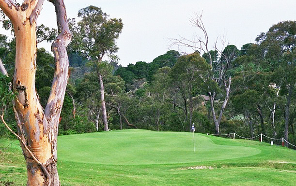
 Katoomba Golf Club this week has been placed into administration – about time!
[Photo by Editor, 20130507, Photo © under ^Creative Commons] Katoomba Golf Club this week has been placed into administration – about time!
[Photo by Editor, 20130507, Photo © under ^Creative Commons]
.
Actor Bing Crosby used to famously play golf back in the 1950s, but in 2013 who plays golf but the last of retired male Baby Boomers? The sport is a ‘has been’ and most courses have been constructed necessitating broadscale habitat destruction, and arrogantly so.

Golf’s origins date back to 15th Century Scotland and to the exclusive pastime of its landed gentry – male gentry, one for Gentlemen Only Ladies Forbidden. Along with croquet and lawn bowls, it dates to a bygone era – up there with duelling, archery practice and pheasant hunting.
This week we learn about the demise of another golf club struggling to attract new members as its 20th Century members ‘pass on’.
In the Blue Mountains west of Sydney, the Katoomba Golf Club as registered body formed just over a hundred years ago back in 1911. The land on which Katoomba Golf Club sited Katoomba Golf Course after the war in May 1923, had few previous owners in historic times.
A brief reflection on relevant colonial history
In the 18th Century, the island continent we now call Australia, was considered ‘undiscovered’ by the then dominant global European powers that be. In 1768, the then head of state of the Kingdom of Great Britain and Ireland, King George III commissioned his Royal Navy to undertake a world expedition voyage under the command of Lieutenant James Cook (combined with Botanist Joseph Banks of the Royal Society) to the south Pacific Ocean aboard HMS Endeavour, which took place between 1768 to 1771. Amongst the voyage’s prescribed tasks were to observe the 1769 transit of Venus across the Sun (3–4 June that year), and to seek evidence of the postulated Terra Australis Incognita or “undiscovered southern land”, plus other exploratory, naturalist and mapping duties.
In April 1770, the voyage famously became the first known European expedition to reach the east coast of Australia, mapping the coastline and making landfall near present-day Point Hicks, and then proceeding north to Botany Bay, naming the land New South Wales.
On 21st August 1770, Cook’s exploration party stepped ashore on an island in the Torres Strait situated 2km off now Cape York Peninsula (since called Possession Island) and declared possession of this “undiscovered southern land” to the British Crown. This was on the basis of unilateral possession – the land perceived as ‘terra nullius’, being Latin for ‘land belonging to no one’, because Cook and Banks considered there were few ‘natives’ along the coast and deduced that there would be fewer or none inland.
Subsequently, the British colonial First Fleet arrived at Botany Bay then Port Jackson in 1788 to establish a British convict settlement was set up in New South Wales.. The Proclamation of NSW Governor Richard Bourke in 1835 implemented the legal principle of terra nullius in Australian law as the basis for British settlement, 47 years later. Such were the powers that prevailed at the time. Various ‘frontier wars’ were waged sporadically between the Aboriginal peoples and the vastly out-weaponed British military and colonists for 46 years (1788-1934). By 1901, Australia was universally declared a unified federated nation state – The Commonwealth of Australia.
This island continent had been ‘legally owned’ (possessed) by the British Crown since Cook’s authorised declaration of possession in 1770. From 1788, the British penal colony of New South Wales was ruled by successive British military governors of the Colony of New South Wales. Until 1824, the military governors of New South Wales were absolute rulers with rights granted to them under an Act of the British Parliament of 1787. The only power superior to them being the British Parliament at Westminster in London, England.
History is history.
So, back to the land of Katoomba Golf Course – obtained historical written records show that the land site was then ‘legally owned’ by the London Chartered Bank of Australia from at least as far back as the 1870s. Katoomba was then not a settlement. Only a sandstone rock quarry ‘The Crushers‘ is historically documented to be in the area to supply ballast for the new railway line roll-out from the 1860s to 1874 when a railway siding was built. It appears that soon afterwards, English migrant (entrepreneurial merchant, miner then property developer) John Britty North acquired vast acreage around the south western area of The Crushers, which would become called the township of Katoomba.
Thus far, our research has not revealed how the local council happened to acquire the land of what would become granted to Katoomba Golf Club in 1920 to deforest the bushland for a golf course. In 1889, Blue Mountains Council did not exist, rather it was one of a number of smaller regional municipal councils across the central Blue Mountains, then it being termed the Katoomba Municipal Council Incorporated).
This is an historic legal document we have obtained that reveals the original deal dated 28th January 1920 between the Katoomba Golf Club and the then local council. At the time the deal was in fact legally between ‘The South Katoomba Land Company Limited‘ and ‘The Council of the Municipally of Katoomba‘. The former was the registered legal body that certain local business owners had established as a legal entity, and the then legally named local council.
 Loading...
Now this is a good revealing read. How’s these stated legal requirements for instance:
-
“Council at its own expense… (read Clause 1), (read Clause 2)”
-
(Clause 3) “THAT the said Council its successors and assign will not at any time erect on the said land any dwelling house or other building except a golf club house or a tennis court or croquet cloub house or a club house for any other purpose for recreation as allowed by paragraph (a) 2 and sheds outhouses stables and other buildings in connection herewith.”
The land was then owned by the then Katoomba Council (i.e. by the local community). The land was acquired from the local council for £1500 by property developers under the name of the South Katoomba Land Company. Was the escarpment land paid for, loaned or gifted? A nearby Gully was acquired a generation later from the Katoomba Council via a £27,000 loan to build a motor racing track, but the loan was never repaid.
So golf playing at the Katoomba Golf Club was in full swing from the 1920’s, and when Bing Crosby was playing during the post War 1950’s, golf was in its heyday. But by the end of the 1980s for reasons of waning interest, other competing interests for a four hour round of golf, busy lifestyles and basic economics; the Baby Boomer golf fad was fading. This was not just across Australia, but across America and elsewhere. Read the article at the end of this one by Nancy Keate, in The Wall Street Journal.

[Source: ‘Is Economy Or Lack Of Interest Hurting Golf?’, 20110523, by Ian Hutchinson ,
^http://www.golfnewsnow.ca/2011/05/23/is-economy-or-lack-of-interest-hurting-golf/]
.
“Over the past week, we’ve been discussing the declining number of golfers, both in Canada and the United States, a topic sparked by this story (see below) by Gene Yasuda of Golfweek.
Of course, the U.S. numbers used by Yasuda were provided by the National Golf Foundation, but here in Canada, we have no recent official numbers to go by, so it could be argued that there’s no cause for alarm about the number of Canadian golfers.
Some might even be tempted to lean on the crutch that Canada is among the world leaders in golfers per capita. Even if that is still the case, it doesn’t necessarily mean that the number of golfer isn’t dwindling.
All golf operators need to do is look out on their fairways and compare the number of golfers out there today to what it was five or 10 years ago to come to a realistic conclusion on how the number of golfers is affecting their businesses and whether it’s up, down or stagnant.
Of course, that number may be affected by the number of golf courses in a saturated market, but the feeling I get from different regions of the country leads me to believe that the number of overall golfers in this country is stagnating at best. If only there were numbers to back that up.
The consensus in the Golfweek story is that the U.S. numbers are affected mainly by the struggling American economy more than a lack of interest in the game.
Here in Canada, however, we’ve come out of the economic downturn a lot quicker that the U.S., but economic factors such as the price of gas and other inflation and the possibility of rising interest rates may be playing a part.
On the other hand, Canadian golf may be feeling the competition from other entertainment and recreation sources, which could indicate a waning interest in the game. While economic pressures on golfers might be a temporary factor, waning interest is more long term.
Which of those two factors do you feel is affecting the number of golfers in Canada? That’s the subject of this week’s GNN Poll.”
U.S. golf participation falls for third consecutive year
May 9, 2011 [SOURCE: http://golfweek.com/news/2011/may/09/us-golf-participation-falls-third-consecutive-year/]
“For the third consecutive year, the number of golfers in the U.S. declined, falling 3.6 percent to 26.1 million in 2010, according to the National Golf Foundation.
The slide, from 27.1 million golfers in 2009, wasn’t unexpected in light of the heavy toll the recession has had on the sport and the economy in general.
The silver lining, if any, according to NGF officials, is that the participation falloff is more linked to financial pressures rather than golf losing popularity among consumers.
“Multiple NGF studies of golfers since 2008 would attribute the gradual decline in golfers and rounds primarily to the impact of lower job security and concern over personal finances, not waning appeal for the game,” said Joe Beditz, NGF president and CEO.
The NGF supported that conclusion by citing golf’s continuing ability to attract “new” participants – in 2010 a total of 3.6 million, including 1.5 million first-time beginners and 2.1 million returning former golfers.
That gain, however, was negated by the loss of 4.6 million golfers who played in 2009 but not in 2010. According to the NGF, the number of new golfers held steady while the number of those who left the game decreased significantly. In recent years, golf industry leaders have been emphasizing improving the retention of golfers.
For all their efforts, though, the downward trend of participation remains a major concern. By comparison, the number of golfers in the U.S. in 2000 and 2005 was 28.8 million and 30 million, respectively.
Among the other findings:
-
-
- The number of “core” golfers (eight or more rounds annually) dropped to 14.8 million – down 3.6 percent from 15.3 million in 2009.
- “Occasional” golfers suffered a similar decline: a drop of 3.7 percent to 11.3 million from 11.8 million in 2009.
- The number of rounds played in 2010 was 475 million, down 2.3 percent from 486 million in the previous year. (By comparison, rounds played in 2000 and 2005 was 518 million and 500 million, respectively.)
The participation study defines a golfer as a person, age 6 or older, who plays at least one round of golf in a given year. Its results are “derived from a multi-sport study of 40,000 Americans, executed in conjunction with the Sporting Goods Manufacturers Association,” the NGF stated.
Yet, despite this general waning interest in golf and despite specifically the falling membership at both Katoomba and nearby Leura golf clubs, some Baby Boomers in complete denial decided in the 1990s to expand the Katoomba golf course from 9 holes to 18. [Editor’s Corrigendum: Correspondence received from an informed reader after publication, has confirmed that the golf course was in fact expanded from 9 holes to 18 holes circa 1927 (^Source). The development works circa 1995 instead relate to expansion of the course acquiring 5.6 hectares of adjoining community zoned woodland alongside Narrow Neck Road in order to build 13 townhouses and a resort hotel. Also circa 2007, a fairway/green was extended into bushland near Stuarts Road.] Further, they had grandiose notions of building a dozen new dedicated golfing townhouses next to the clubhouse, so perpetuating the ‘has-been’ American trend of the 1980s.
Where did the millions in development finance come from and how much was put up by local Blue Mountains Council negotiated behind closed doors claiming a dubious excuse fo commercial in confidence” dealing with this being zoned ‘Community Land‘ ?
Of course, this development necessitated a considerable acquisition of more surrounding bushland to be logged, the vegetation slashed and bulldozed, the soils landscaped, grassed and fertilised. This has meant permanent destruction of the ecosystem just like open cut mining. All this occurred immediately above and upstream of the Jamison Valley wilderness, now part of the Blue Mountains World Heritage Area.
.
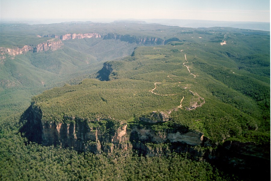
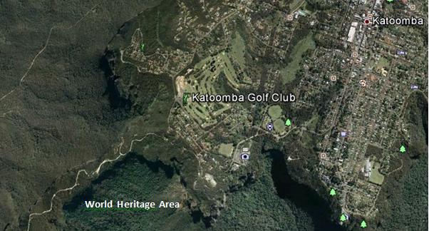 Juxtaposition of the Katoomba Golf Club (light green coloured fairways) replacing virgin habitat across the escarpment; all so that a few retiring Baby Boomer men can selfishly play golf at the expense of Ecology.
[Source: Google Earth, 2013] Juxtaposition of the Katoomba Golf Club (light green coloured fairways) replacing virgin habitat across the escarpment; all so that a few retiring Baby Boomer men can selfishly play golf at the expense of Ecology.
[Source: Google Earth, 2013]
.
During the construction of the additional nine holes [Editor’s Corrigendum: The construction instead related to building 13 townhouses and a resort hotel], the development proposal submitted to the local Blue Mountains Council, specified a new track would be constructed through adjacent bushland to connect two fairways. It was deceptive, because that track became a new wide fairway, complete with soil replacement, landscape contouring, grass seeding and fertilizer.
Repeated instances of sediment run-off from the construction were formally reported to the local Blue Mountains Council by concerned local residents, yet no remediation action was undertaken and no punitive fines were issued.
.
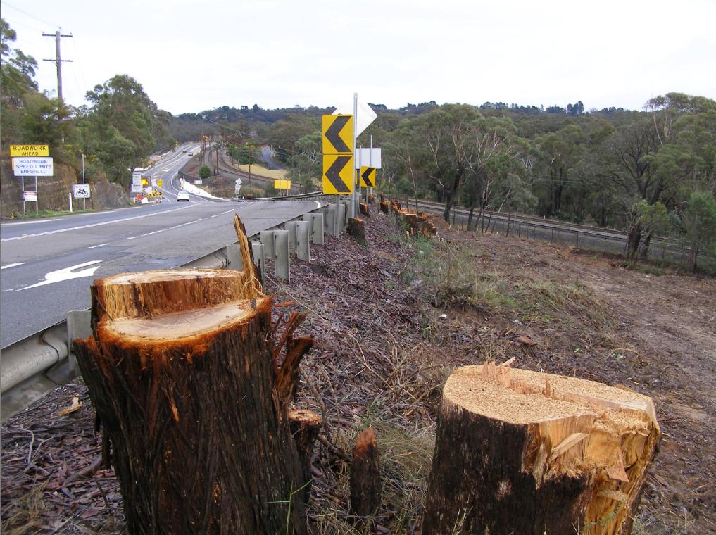
 Native bushland along the Blue Mountains escarpment slashed and woodchipped to expand the Katoomba Golf Club out to 18 holes
[Editor’s Corrigendum: The construction instead related to building 13 townhouses and a resort hotel]
[Photo by Editor, 20071110, Photo © under ^Creative Commons] Native bushland along the Blue Mountains escarpment slashed and woodchipped to expand the Katoomba Golf Club out to 18 holes
[Editor’s Corrigendum: The construction instead related to building 13 townhouses and a resort hotel]
[Photo by Editor, 20071110, Photo © under ^Creative Commons]
.
.
 Native bushland bulldozed to make way for golfing townhouses adjacent to the Katoomba Golf Club
Erosion and sediment run-off has been rife for years
[Photo by Editor, 20071110, Photo © under ^Creative Commons]
Native bushland bulldozed to make way for golfing townhouses adjacent to the Katoomba Golf Club
Erosion and sediment run-off has been rife for years
[Photo by Editor, 20071110, Photo © under ^Creative Commons]
.
Golf courses not only necessitate absolute ecological destruction in such places, but the ongoing maintenance of the fairways and greens demands constant fresh water irrigation. Irrigation, as with farming, risks causing saline intrusion into the groundwater.
The keeping of golfing greens green to uphold the lush traditional image, necessitates that golf courses use extensive amounts of chemical fertilizers containing elevated levels of nitrogen (as sulphate of ammonia), potash , sulphur and phosphorus, as well as the application of pesticides and herbicides. All such chemicals are toxic to Australian native vegetation and to aquatic wildlife in the downstream watercourses. Effectively they are environmental pollutants and so next to and upstream of vital World Heritage, use of such chemicals needs to be legally banned.
The local Blue Mountains Council has failed to monitor run-off from the construction activity into the surrounding natural environment. The custodian of the World Heritage Area, National Parks and Wildlife Service, simply isn’t interested.
.
.
 White Elephant golfing townhouses adjacent to the Katoomba Golf Club that have since stood vacant for years
[Photo by Editor, 20071110, Photo © under ^Creative Commons]
.
 << It’s big, blue and beautiful! Blue Mountains National Park is located just 60 kilometres west of Sydney. It is unique in it’s history, its wildlife and world famous scenery…includes the Grose Wilderness, dedicated for its wild unspoilt natural beauty. At Katoomba see the Three Sisters and Katoomba Falls… 300 kilometres of heritage walking tracks and hundreds of lookouts, most within easy reach of a string of train stations. It’s a wilderness made easy to get to! >> << It’s big, blue and beautiful! Blue Mountains National Park is located just 60 kilometres west of Sydney. It is unique in it’s history, its wildlife and world famous scenery…includes the Grose Wilderness, dedicated for its wild unspoilt natural beauty. At Katoomba see the Three Sisters and Katoomba Falls… 300 kilometres of heritage walking tracks and hundreds of lookouts, most within easy reach of a string of train stations. It’s a wilderness made easy to get to! >>
[Source: NSW Government, ^http://www.visitnsw.com/destinations/blue-mountains/katoomba-area/blackheath/attractions/blue-mountains-national-park]
.
[Ed: No mention of golf in the tourism promotion these days]
.
Katoomba Golf Club R.I.P.
.
<<..“the locksmith has been in” and the club is no longer trading.
Unfortunately the club has temporarily closed its doors to the public. They have appointed administrators to handle the business. We are no longer employed. We, the staff thank all of you for your patronage, your friendship, your laughs and your well wishes – it has been a wonderful and memorable time for all of us. A bit of a sad day for us, so thank you. >>
[Source: ‘Katoomba Golf Club shuts its doors’, 20130703, Blue Mountains Gazette, print, p.5, ^http://www.bluemountainsgazette.com.au/story/1614280/katoomba-golf-club-shuts-its-doors/?cs=2062]
.
 Escarpment Karma?
Yet over 50 hectares of vital escarpment habitat has been lost
to a Baby Boomer selfish pastime. Escarpment Karma?
Yet over 50 hectares of vital escarpment habitat has been lost
to a Baby Boomer selfish pastime.
.
Notice of First Meeting of Creditors of Company Under Administration
.
Company: Katoomba Golf Club Ltd
ACN: 000 952 992
Status: Administrators Appointed
Appointed: 01 July 2013
.
Meeting details:
Notice is given that a first meeting of the creditors of the Company, or a first meeting for each of the Companies, (for multiple companies), will be held:
Location: Katoomba Golf Club, Acacia Street, Katoomba New South Wales
Meeting date: 10 July 2013
Meeting time: 12:00PM
.
[Source: ASIC Insolvency Notices].
.
.
‘Fore Sale – Luxury golf communities have hit a rough patch’
[Source: ‘Fore Sale – Luxury golf communities have hit a rough patch’, 20120724, by Nancy Keate, The Wall Street Journal, ^http://online.wsj.com/article/SB10001424052702303703004577474563368632088.html]
.
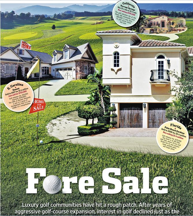 Photo Illustration: Jeff Huang
.
<< After years of aggressive golf course expansion, interest in golf declined just as the market for luxury homes plunged. Now, once-pricey real estate is available at below-par prices. Selling a lot for $1.
Debbie Bowers and her husband, tired of life in their cold Ohio town, spent eight years looking for a home near a sunny luxury golf course in a Southern state. Everything they saw was too expensive. Then this past May, they got a call: A lot was available at South Carolina’s Colleton River Plantation, one of the country’s premiere golf communities—for free.
Prices at luxury private golf communities are crashing, done in by rampant overdevelopment, the economic downturn and waning national interest in the sport. Nancy Keates has details on Lunch Break.
The seller was even willing to pay the $15,000 club initiation fee and the first year of $17,000 annual membership dues at Colleton River, which includes three celebrity-designed courses (two by Jack Nicklaus, one by Pete Dye), a Stan Smith-designed tennis center and a new 6,000-square-foot fitness center. Mrs. Bowers, 55, met her husband that day at the site and signed the papers. They’re now building a 3,000-square-foot house that should be finished by November.
The past two decades saw an unprecedented boom in the building of high-end golf courses linked to luxury real-estate communities. Betting that aging Baby Boomers would embrace golf as their pastime of choice, the National Golf Foundation set a goal of building “A Course a Day” beginning in 1988. Real-estate developers teamed up with top-name golf-course architects, building exclusive communities adjacent to courses, and requiring homeowners to pay annual club dues—sometimes even if they didn’t play. Then, in a moment of spectacularly bad timing, both the golf industry and the real-estate market took a nose-dive at once.
Now, private golf communities are dealing with the fallout. Many sellers are dropping their prices radically, in some cases even paying people to take their land. Gated communities that once traded on their exclusivity are aiming to appeal to a wider swath of buyers, building family-friendly “village centers” with ice cream shops, hiking trails and bowling alleys. A few are even “repurposing” by reducing courses to nine holes from 18 and selling off the reclaimed land.
At golf communities near Bluffton, S.C., like Belfair Plantation, Colleton River Plantation and Berkeley Hall, several lots that initially sold for at least $150,000 are now on sale for $1 apiece. Investors who bought but never built on the sites are trying to unburden themselves of the thousands of dollars—typically $12,000 to $17,000—they still have to pay in annual club dues.
At the Mizner Country Club in Delray Beach, Fla., which has an Arnold Palmer golf course, a lakefront home with five bedrooms, a pool and a spa is asking $795,000. It sold for $1.6 million in 2007. A lot in Horseshoe Bay Resort, near Austin, Texas, that sold previously for $300,000, is on sale for $39,000.
In Bend, Ore., interior designer Ronda Fitton and her husband paid $500,000 for a lot at Pronghorn, a gated community with golf courses designed by Tom Fazio and Jack Nicklaus, in 2006. A similar-size lot sold for $10,000 earlier this year. Ms. Fitton is hopeful values will go up but she says the lot is “worth nothing now. It’s a real bummer.” (Lot prices exclude membership fees.) Lots at Rams Hill in Borrego Springs, Calif. are also selling for about $10,000, compared with $100,000 at the peak.
The housing downturn is partly responsible. But the crash in value has been exacerbated by a development binge that resulted in too many courses just as the sport of golf began to fade in popularity.
From 1990 to 2003, some 3,000 new courses were built in the U.S., swelling the total number of courses nationally by 19% and costing about $20 billion, according to the National Golf Foundation.
Many of these new courses were inextricably linked to the luxury-real-estate market. About 40% of the courses built during the 1990s were tied to real-estate communities—a shift from the previous decades, when that number was closer to 18% and the vast majority of golf courses didn’t have people living on them. The golf courses were the lure to get people to buy houses: The bigger the name of the architect who designed them, the greater the prestige and the more expensive the real estate.
Soon after, however, the sport started to lose its allure. The percentage of the overall population in the U.S. that plays golf is down over the past 10 years, from 11.1% in 2000 to 9.2% in 2010, according to the National Golf Foundation.
Last year the number of rounds played in the U.S. dropped to 463 million from 518 million in 2000. The number of golfers fell to 25.7 million in 2011 from 28.8 million in 2000. A net of more than 350 golf courses have been closed since 2005. In 2011, more than 150 courses closed, outpacing the 19 courses that debuted last year.
Compounding the problem: Real-estate developers didn’t think about the viability of the golf courses themselves, says Art West, founder of Golf Course Advisors, a golf-course consulting company. Many of these courses designed by brand-name golf-course architects were championship-level, too difficult for the average player. They took a long time to play and cost millions a year to maintain, pushing up annual dues.
“It was a perfect storm,” says David Hueber, former president and CEO of the National Golf Foundation, who wrote a paper called ” ‘Code Blue’ for U.S. Golf Course Real Estate Development” stemming from research for his Ph.D. in real-estate development at Clemson University.
Across the country, about 2,000 of the 16,000 golf courses are “financially distressed,” according to the National Golf Foundation. Mr. Hueber estimates that 4,000 to 5,000 golf courses will be in financial danger if they don’t change their model.
Membership fees for many clubs have tumbled. The initiation fee at Old Palm Golf Club in Palm Beach Gardens, Fla., which was as high as $250,000 in 2007, is now down to $175,000, while the fee at Tiburon Golf Club in Naples, Fla., is now at $50,000, compared with $145,000 at its peak.
In some parts of the country, the premium that home buyers are willing to pay for a house on a golf course versus a house that isn’t on a course has dropped to about 25%, from 50% in 2007, says Doug Schwartz, who runs the sales, marketing and homebuilding operations for WCI Communities, in Bonita Springs, Fla., which currently owns four golf communities. Lisa Treu, an agent with the Treu Group in Palm Beach County, says homes on golf courses in Southeast Florida could at one time command a 25% premium over non-golf-course homes; that premium has now dropped to about 10%, she says. (Some areas are still strong, like Palm Springs, Calif., where agents say the premiums are as much as 35%).
“There are a lot of people who would like to get out of here because of the economy,” says Don Davis, who with his wife bought a house in South Carolina’s Colleton River for $970,000 in 2001. The couple, who have loved living in the community but want to move back to Atlanta to be closer to their grandchildren, say it doesn’t make financial sense to move without selling their house because they’d still have to pay the community’s annual membership dues of some $17,000. Their house, listed at $775,000, hasn’t had any offers in its six months on the market.
Real-estate agent Dick Datz of Carolina Realty Group says Belfair and Colleton River are offering agents a $5,000 bonus when they sell a $1 lot; otherwise the commission would be pennies. Rob Norton, president of the Colleton River Plantation Board, says houses in the community are selling and there’s lots of new construction. It’s mostly the people who bought the land as an investment who are having a hard time, he says.
Some developers are recasting their golf communities to appeal to a broader swath of home buyers, including more families and young people. One example: Tuscany Reserve, a 450-plus-acre private golf community in Naples, Fla., which had about $200 million invested in its infrastructure, including a golf course designed by Pete Dye and Greg Norman, before it went bankrupt. Florida developer Syd Kitson recently bought the community for $30 million and changed the name to Talis Park, which he thought sounded more youthful. Instead of building a clubhouse as planned, Mr. Kitson, will build a “village center” with a cafe, a spa and walking paths. Homes are now expected to be in the $700,000-to-$2 million range instead of up to $6 million, as originally intended.
“The model of a country club in its current form is gone forever,” says Mr. Kitson.
After seeing sharp decreases in its sale prices, Pronghorn, the gated community in Bend, Ore., opened its gates, launching a 48-suite lodge in 2010 and inviting the public to use one of its two golf courses. The Resort Group, a resort operator based in Honolulu, Hawaii, took over in February and announced it will bring in Auberge Resorts to manage the property, turning it into a five-star resort with a spa, three restaurants, two pools, tennis courts and a kids club.
The Cliffs—a group of eight residential developments spread among 20,000 acres between Greenville, S.C., and Asheville, N.C., with golf courses designed by Jack Nicklaus and Tom Fazio—filed for U.S. Bankruptcy Court protection in February, with estimated liabilities between $100 million and $500 million. A planned golf course for the Cliffs, designed by Tiger Woods, hasn’t been started. According to a 2007 news release, the Cliffs sold 40 lots in the $500,000 price range, and lots at that time couldn’t be purchased below $200,000. Earlier this year a lot sold in one high-end community for less than $10,000, according to real-estate agent Justin Winter.
Owners at the Cliffs, who tried to bail it out earlier by putting up $64 million to keep the club operating, say they are optimistic and are in the midst of a reorganization with Carlile Group, a diversified company based in Marshall, Texas. Carlile is working with two other groups.
Owners say the revamped club will have more options for membership. The initiation fee, which was $150,000, is now $50,000. “We are working diligently to find and deliver the best solution for all members and property owners at the Cliffs,” Steve Carlile of Carlile Group says in a statement.
Golf-course architect Bobby Weed of Bobby Weed Golf Design has been helping residential golf communities over the past few years “repurpose”—by compressing the properties. He is currently working on several proposals to shrink 18-hole courses to nine holes. At the Deltona Club in Deltona, Fla., he helped reduce the amount of land used by the clubhouse and the golf course to create a separate, 17-acre parcel for development.
The steep decline in prices is a boon for potential buyers, of course. “Now I’m getting worried I’m going to miss out if I don’t move quickly,” says Gordon Flach, 44, who has been looking for a golf resort home in Montana, Utah or Oregon for the past three years. Mr. Flach, who is part owner of a resort in the Bahamas, has his eye on a $425,000, 3,800-square-foot four-bedroom house in Pronghorn. A similar house was going for $1.1 million when he first started looking.
Ron Ruff, a 55-year-old semiretired anesthesiologist, got his lot at Pronghorn free about a year ago. The seller also kicked in part of the $115,000 reimbursement of his golf-club membership initiation fee he got back when he “sold” the land. Mr. Ruff says that he felt, despite the dire climate and other people thinking he was crazy, that Pronghorn has a “magical” feel and that the value would be realized again, just as he had seen happen in other areas before. His house is now complete.
John Reed, the original developer of Colleton River Plantation, Belfair Plantation and Berkeley Hall, concedes there are too many golf-course communities. “There’s a train wreck in the industry now,” he says. “We overbuilt and the market stopped.” He had Pete Dye and Tom Fazio design a golf course for his latest development, called Hampton Lakes, but decided to nix it in favor of a 165-acre freshwater fishing and boating lake.
“The best golf course we ever did is 9 feet underwater,” he jokes. >>
.
Tags: baby boomer, Blue Mountains Council, Blue Mountains Escarpment, Blue Mountains World Heritage Area, BMCC, broadscale habitat destruction, chemical fertilizers, Community Land, eco-rapist sport, escarpment slashed, golf, golf course development, golfing townhouses, institutionalised sport, irrigation, Jamison Valley Wilderness, Katoomba Golf Club, run-off, The Escarpments
Posted in Blue Mountains (AU), Threats from Development, Threats from Selling Public Land, Threats from Tourism and Recreation | 8 Comments »
Add this post to Del.icio.us - Digg
Leave a Reply
You must be logged in to post a comment.
July 2nd, 2013
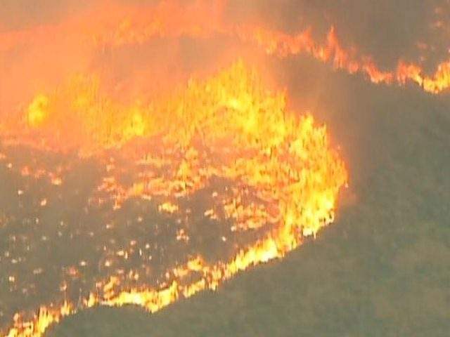 America tragically loses 19 elite firefighters in an Arizona Wildfire
[Source: ‘Arizona firefighter deaths’, 20130702, by Holly Yan, Eliott C. McLaughlin and Jason Hanna, CNN, ^http://edition.cnn.com/2013/07/01/us/arizona-firefighter-deaths/index.html] America tragically loses 19 elite firefighters in an Arizona Wildfire
[Source: ‘Arizona firefighter deaths’, 20130702, by Holly Yan, Eliott C. McLaughlin and Jason Hanna, CNN, ^http://edition.cnn.com/2013/07/01/us/arizona-firefighter-deaths/index.html]
.
An American elite squad of wildfire firefighters perished last Sunday 28th June 2013 while actively setting up containment barriers in front of an out-of-control wildfire front.
The 19 firefighters who tragically perrished in the blaze were members of the Prescott Fire Department’s Granite Mountain Hotshots. The fire concerned was termed the Yarnell Hill Wildfire, about 80 km northwest of the city of Phoenix, Arizona.
Prescott Fire Chief Dan Fraijo, who sent the unit at the request of regional authorities, said he was told that one of the firefighters had radioed they were about to deploy their fire shelters, a sort of aluminum blanket that protects against the flames and heat — and a measure of last resort.
.
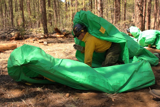 Flawed Survival Strategy demands questions/ Class Action
.
.
Yarnell Hill Wildfire
.
Day 1
.
The wildland fire is believed started by lighting at around 5:30 pm on Sunday 28th June 28, 2013 near the township of Yarnell (pop. 700) Arizona.
Medium winds at the time (up to 35 kph) whipped up the flames and pushed the fire out of control into a wildlife front through a tinder dry forest vegetation long subjected to an extended drought. By day’s end the wildfire has spread to over 2,000 acres (810 hectares).
A highest qualified, Type 1 elite squad of 19 wildfire firefighters (members of the Prescott Fire Department’s Granite Mountain Hotshots) were sent in ahead of the fire front to set up containment barriers to prevent the fire impacting the downwind township of Yardell. They were all overrun by the fire and perished. In the late afternoon, a Type 2 Incident Management Team (IMT) was in charge of the fire. A Type 2 fire-fighting team is a State-certified but has less training, staffing and experience than Type 1 IMTs, and is typically used on smaller scale national or state incidents.
Firefighting resources included 16 tank engines, eight water tenders, two crash/rescue vehicles, two structure protection vehicles, one bulldozer, one hotshot crew (that perished), seven type 2 handcrews and a camp crew.
On order were an additional four Type 2 crews, four Type 1 hotshot crews, one Very Large Airtanker (VLAT) and an air attack unit.
The nearby Arizona State Route 89 was shut down shortly after the fire started and the total evacuation of Yarnell and partial evacuation of Peeples Valley was ordered as well. Some 600 people were put under mandatory evacuation orders. An evacuation shelter was set up at Yavapai College in Prescott, with members of the Red Cross providing cots and blankets for overnight stays. Meals and medical assistance were also provided to residents.
A second evacuation shelter was set up at Wickenburg High School in nearby Wickenburg because the closure of State Route 89 made it impossible for some people to reach the first shelter. The two shelters are serving individuals, families and small animals; large animals were sheltered at the Hidden Springs Ranch in Peeples Valley.
.
Day 2
.
The Clay Templin’s Southwest Area Type 1 Incident Management Team assumed management of the fire. About 200 more firefighters arrived to the scorching mountains, doubling the number of firefighters battling the blaze.
By day end, half of Yarnell, about 200 to 250 homes, had been destroyed and the fire had grown to over 8,300 acres (3,360 ha).
.
Day 3
.
By the morning of July 2 the fire had grown another 798 acres to a total of 9,172 acres, as mapped by an infrared aircraft flight. The fire was still at zero containment. Resources included five Type 1 (hotshot) crews, seven Type 2 crews, three Type 1 (heavy) helicopters, two Type 2 (medium) helicopters, two Type 3 (light) helicopters, and 36 engines.
The fire was still completely uncontrolled, with more than 400 firefighters on the line.
.
Questions of the U.S. Fire Administration
.
Before the 19 deaths in Arizona, 43 firefighters had been killed so far in 2013, according to the U.S. Fire Administration. A total of 83 firefighters died last year while on duty.
This is unacceptable in 2013 in the wealthiest and most technologically advanced country on the planet.
.
- What is the cost-benefit of putting ANY firefighters (paid or otherwise) in the direct path of a firestorm? Benefit: nil? Cost: the ultimate cost?
- What were the methods of wildfire detection used by the U.S. Fire Administration at this known high risk region under extreme wildlfire weather conditions 24/7?
- Are infrared geostationary satellites in place to immediately detect wildfire ignitions in known high risk regions at known high risk weather conditions 24/7? If not, why not?
- Are wildfire ignitions monitored by satellite immediately communicated to the U.S. Fire Administration and incident crews 24/7? If not, why not?
- What was the elapsed time delay:
- Between estimated actual ignition(s) and detection by the U.S. Fire Administration? Is this time lapse acceptable to communities vulnerable during such extreme risk conditions?
- Between detection by the U.S. Fire Administration and actual onground firefighting response? Is this time lapse acceptable to communities vulnerable during such extreme risk conditions?
- Between detection by the U.S. Fire Administration and airborne water dumping hitting the fire front? Two hours? Five hours?
- Why was not multiple co-ordinated airborne response not immediately deployed within the first critically hour of the ignition to suppresss the fire while it was small and comparatively containable?
- Would such a dedicated co-ordinated military strategy have saved the 19 Granite Mountain Hotshots and the town of Yardell?
- Is the massive cost of military-scale wildlife monitoring and readiness justified to avoid loss of life in future? This is a value decision for vulnerable communuties.
.
 In 1804, one William Clark recorded perhaps the first account of a wildland fire fatality in US history.
“The Prarie was Set on fire (or cought by accident) by a young man of the Mandins, the fire went with such velocity that it burnt to death a man & woman, who Could not get to any place of Safty (sic).”
Two hundred years hence, Americans have wised up some or have they? In 1804, one William Clark recorded perhaps the first account of a wildland fire fatality in US history.
“The Prarie was Set on fire (or cought by accident) by a young man of the Mandins, the fire went with such velocity that it burnt to death a man & woman, who Could not get to any place of Safty (sic).”
Two hundred years hence, Americans have wised up some or have they?
.
Leave a Reply
You must be logged in to post a comment.
June 30th, 2013
The following article was initially published on ^CanDoBetter.net 20091218 by Tigerquoll.
.
.
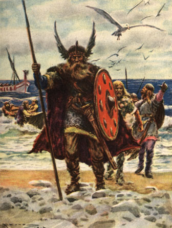
Copenhagen was a deadline without a plan.
Like Vikings, they rushed in. Too many issues, too many causes, too many delegates, too much reading, too many options and yet forced to deliver a global consensus solution in just 2 weeks!
Copenhagen’s approach ought to have been pragmatic. It needed to come down from the stratosphere in idealistic thinking to have focused on what could be the fastest means to offer the greatest reduction in greenhouse gases commencing in 2010.
Money is the obvious facilitator. The G11 response to the Global Financial Crisis ‘Mark I’ demonstrated the sheer scale of quick cash available from developed nations. Since developing nations need the cash, therein lies an obvious negotiating connector.
Try this scenario… rank countries on the basis of their aggregate carbon emissions and also carbon emissions per capita. The size of reduction responses and the amount of funding for carbon reduction programmes should be proportional on both bases. That is, the worst emitting developed nations pay more, and the worst emitting/deforesting developing nations get compensated more not to log.
Pay compensation to countries to stop deforestation is simply a matter of money and there is certainly enough of that around it seems. This should start by Christmas – calculate the forest area, calculate the compensation value, sign the agreement, developing countries contribute to a trust account, transfer the funds electronically to the host country of the forests, send in UN monitors to enforce the agreement to make sure no trees fall. If Copenhagen just did that, it would have achieve a significant inroad – 20% reduction in one year or something in that order.
News of the pledge by US based Climate Progress of US$1 billion over three years towards decreasing deforestation is an excellent outcome. The funding will go to developing countries that develop REDD (Reducing Emissions from Deforestation and Degradation) programs.
But horse trading in emissions is pure problem avoidance. Perhaps a less patriarchal culture may have helped too. Perhaps less Viking patriarchal culture and perhaps a more matriarchal approach to negotiation would have achieved better. The alpha male approach has clearly failed.
‘COP15’ was also a silly name. It just meant the 15th United Nations Climate Change Conference. Rather than the meaningless ‘COP15’ (‘Conference of Parties’ #15) , such a vital global forum series deserves a more accessible and meaningful name in order to better engage with ordinary folk.
Perhaps instead a better name should be ‘Greenhouse 2009’, then work towards ‘Greenhouse 2010’, ‘Greenhouse 2011’ – for each year, setting and achieving a distinct global reduction outcome by legal treaty. Such numbering and annual frequency would better convey the sense of urgency.
.
 This is Malaysia
Don’t holiday in Malaysia. Don’t fly Malaysian Airlines.
This is Malaysia
Don’t holiday in Malaysia. Don’t fly Malaysian Airlines.
.
Leave a Reply
You must be logged in to post a comment.
June 29th, 2013
 Toxic liquid chemicals being trucked through the Blue Mountains World Heritage Area
.
The New South Wales Government decision in the late 1990s to permit 19-metre B-doubles to operate along the Great Western Highway was recognised by many informed Blue Mountains residents as the thin end of the wedge to encourage bigger and faster trucks and to extend Sydney sprawl.
Its planning minister in 2008, Frank Sartor, famously heralded:
.
“Few understand how much transport influences land use patterns. Transport leads land use. Once an expressway or railway is built, it is easy to change the zoning and development laws to increase the population along the corridor.”
.
~ Frank Sartor, NSW Planning Minister, Sydney Morning Herald, 20080929, p11.
.
The Greater Blue Mountains is a vast forested wilderness covering over one million hectares, characterised by ancient sandstone tablelands and escarpments, ancient temperate eucalypt forest types, rainforests, heathlands and swamps containing rare and endemic flora and ecological communities. It was formally inscribed on the World Heritage List on 29 November 2000 and constitutes one of the largest and most intact tracts of protected bushland in Australia.
.
 Jamison Valley wilderness and beyond
Blue Mountains World Heritage Area
[Photo by Editor, 20130307, Photo © under ^Creative Commons,
click image to enlarge] Jamison Valley wilderness and beyond
Blue Mountains World Heritage Area
[Photo by Editor, 20130307, Photo © under ^Creative Commons,
click image to enlarge]
.
Along the headwaters of the Jamison Valley above Wentworth Falls, the Jamison Creek flows as a stormwater drain underneath the Great Western Highway.
On or about 7th July 2012, a large quantity of toxic pyrethrin, used as a fumigation pesticide, was dumped into the creek resulting in extermination of all aquatic wildlife downstream and into the World Heritage below. [Source: ‘Health risk posed by Wentworth Falls creek, 20120711, Blue Mountains Gazette newspaper, ^http://www.bluemountainsgazette.com.au/story/273589/health-risk-posed-by-wentworth-falls-creek/]
A year on and still no prosecution has been made against the culprit known by both the local council and the EPA. The contamination could easily have come from the overturning of one of the many trucks that ply the highway now carting toxic chemicals, nudging 90kph.
The Great Western Highway winds its way over the central plateau ridgeline of the Blue Mountains east to west from Sydney. In every respect, the Greater Blue Mountains World Heritage Area is juxtaposed downstream of this highway.
.
 Great Western Highway at Boddington Hill before the Trucking Expressway conversion
The notorious greenwashing sign
[Photo by Editor, 20100327, Photo © under ^Creative Commons]
Great Western Highway at Boddington Hill before the Trucking Expressway conversion
The notorious greenwashing sign
[Photo by Editor, 20100327, Photo © under ^Creative Commons]
.
Increasingly, the Great Western Highway is becoming dominated by larger trucks and an increasing frequency of B-Double Trucks carting sand and soil, containers, palletised freight, heavy machinery and bulk liquids. Transport companies are not delivering to the Blue Mountains; they are transiting through the Blue Mountains for destinations far beyond including Perth and Darwin.
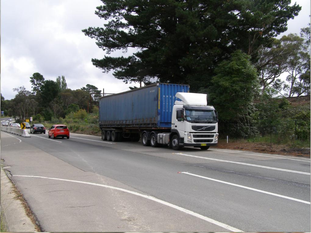 One of the many thousands of larger trucks that now dominate the Great Western Highway
Political lobbying by trucking companies continues to be the prime driver for the multi-billion conversion of this regional highway into a 4-laned interstate Trucking Expressway nudging 90kph.
[Photo by Editor at Bullaburra looking west, 20130406, Photo © under ^Creative Commons] One of the many thousands of larger trucks that now dominate the Great Western Highway
Political lobbying by trucking companies continues to be the prime driver for the multi-billion conversion of this regional highway into a 4-laned interstate Trucking Expressway nudging 90kph.
[Photo by Editor at Bullaburra looking west, 20130406, Photo © under ^Creative Commons]
.
However, local Blue Mountains supporters of this website have informed us that recently the trend is worse, with chemical tank containers now being sighted. The company transporting these bulk chemicals is Chemtrans, a subsidiary of corporate trucker, Scott Corporation, based in Sydney’s west industrial suburb of Padstow.

The tanks display hazardous warnings on the sides.

What chemicals are being trucked over the Blue Mountains anyway?
.
-
Sulphuric Acid?
-
Phosphoric Acid?
-
Anhydrous Ammonia?
-
Vinyl Chloride Monimor?
.
Kills Nature

How can this be? What if there is a crash and a spill?
.
With substandard toxic containment infrastructure, World Heritage dies.
.
The Great Western Highway is not designed to contain large flash runoff from storms, let alone contain chemical spills toxic to ecology from entering the downstream headwaters and water courses that flow from the ridgeline down into the surrounding Greater Blue Mountains World Heritage Area.
.
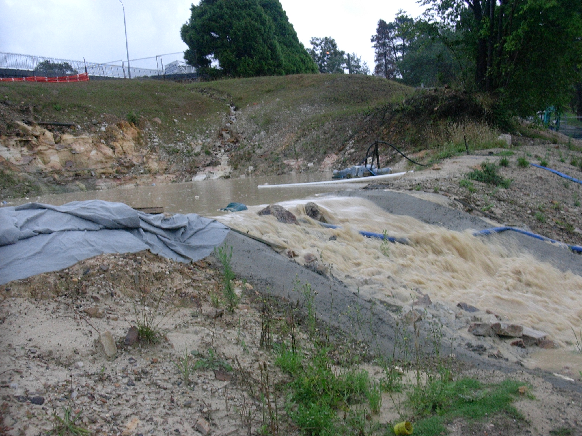 The notorious Leura Retention Basin overflowing during the construction of the Trucking Expressway in 2006
The NSW Government allowed hundreds of tonnes of piled construction sand to wash into and fill the surrounding watercourses and into the World Heritage Area
The then RTA Project Manager, Iain MacLeod, tried excuse the seasonal frequent and heavy rainfall as ‘One in a Hundred Year Events’
[Photo by Editor at Leura north side of highway, 20060116, Photo © under ^Creative Commons]
The notorious Leura Retention Basin overflowing during the construction of the Trucking Expressway in 2006
The NSW Government allowed hundreds of tonnes of piled construction sand to wash into and fill the surrounding watercourses and into the World Heritage Area
The then RTA Project Manager, Iain MacLeod, tried excuse the seasonal frequent and heavy rainfall as ‘One in a Hundred Year Events’
[Photo by Editor at Leura north side of highway, 20060116, Photo © under ^Creative Commons]
.
So when did the NSW Government give permission for bulk toxic chemicals to be transported through the Blue Mountains? What community consultation did the government not engage in? What legislative safety and governance restrictions were not enacted?
.
  . .
She’ll Be Right, eh Barry O’Farrell?
.
..Just like when in May this year, a FULLY-LADEN DOUBLE FUEL TANKER overturned in a short, straight, three-laned section of the highway between Katoomba and Medlow Bath in the early hours of Sunday, May 12. The giant rig owned by Orange-based Ron Finemores Transport was being driven west when it veered onto the road shoulder and overturned down an embankment, coming to rest with the twin tankers upside down.
She’ll Be Right, eh Barry O’Farrell?
.

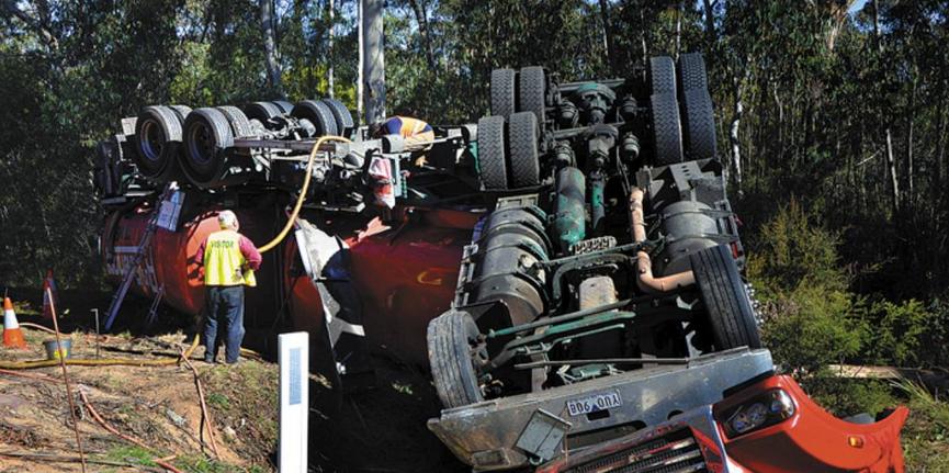 The scene at Sunday morning’s truck crash near Medlow Bath.
Driver fatigue is suspected as a possible cause of the smash.
[Source: Photo: Len Ashworth, Lithgow Mercury, in article ‘Lucky escape for truck driver, 20130515, by Len Ashworth, Blue Mountains Gazette newspaper, ^http://www.bluemountainsgazette.com.au/story/1500162/lucky-escape-for-truck-driver/]
The scene at Sunday morning’s truck crash near Medlow Bath.
Driver fatigue is suspected as a possible cause of the smash.
[Source: Photo: Len Ashworth, Lithgow Mercury, in article ‘Lucky escape for truck driver, 20130515, by Len Ashworth, Blue Mountains Gazette newspaper, ^http://www.bluemountainsgazette.com.au/story/1500162/lucky-escape-for-truck-driver/]
.
The tanker overturned in bushland just upstream from the Cascade Water Catchment that stores drinking water for the region and in which fines for tresspass are $44,000.
But Ron Finemores Transport was not fined the $44,000. Why not?
.
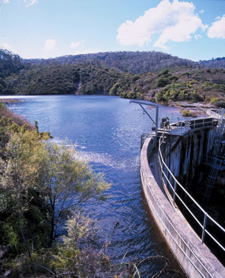
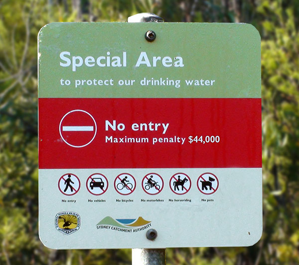
.
Sydney Water ‘Special Areas’ prohibit public entry in order to protect water quality.
This benefits the community by:
- Protecting water quality
- Protecting large areas of bushland and plant and animal habitats
- Protecting threatened plants and animal species
- Preserving evidence of Aboriginal occupation dating back many thousands of years, and
- Preserving evidence of non-Aboriginal exploration, early settlement and phases of development such as forestry, mining and dam building.
.
[Source: Sydney Catchment Authority, NSW Government, ^http://www.sca.nsw.gov.au/the-catchments/special-areas]
.
What Next? Trucking nuclear waste through the Blue Mountains?
.

Don’t put it past them. There are plans afoot to truck radioactive waste and parts of Australia’s old 1960s nuclear reactor out of Sydney under plans to clean up the Lucas Heights nuclear facility and develop a national hazardous-waste dump in the outback.
The trucks will necessarily pass by residential homes carrying a radioactive high-flux reactor’ and spent fuel rods.
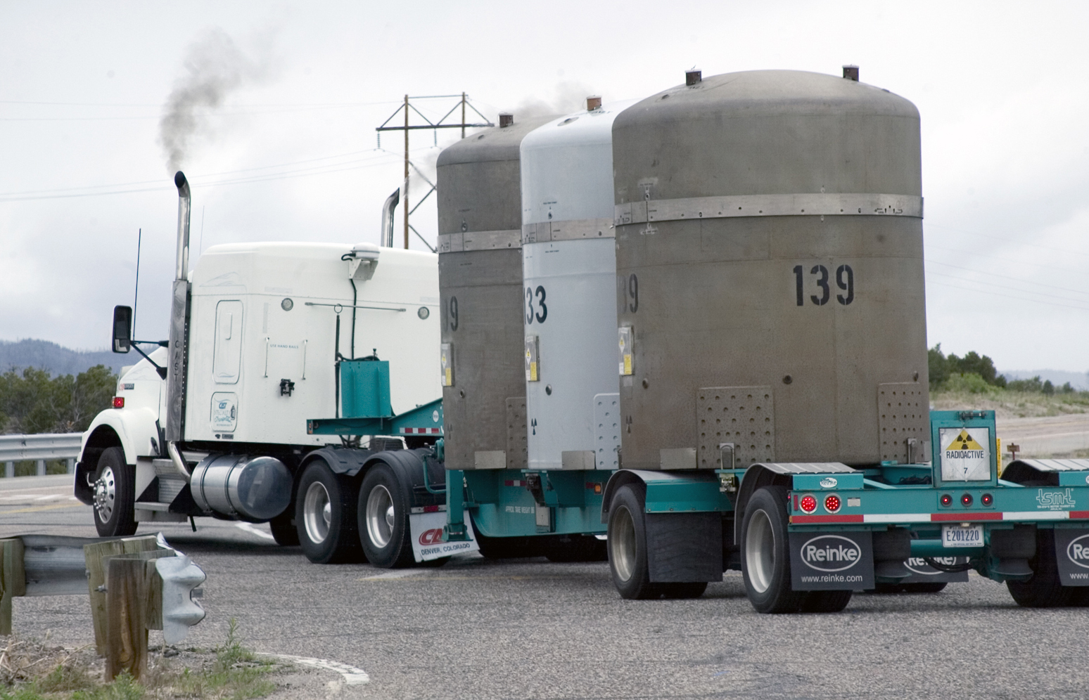
The Sources of Radioactive Waste
.
- The Australian Nuclear Science and Technology Organisation, which manages the Lucas Heights Nuclear Reactor, has been given $28.7 million to prepare for the move. The four-year funding package will pay for ‘pre-disposal conditioning of existing radioactive waste in preparation for long-term underground storage, including radioactive contaminated buildings and infrastructure at Lucas Heights.
- Also planned to be trucked is nuclear contaminated soil waste from the former uranium smelter site at Hunters Hill.
- Also planned to be trucked is spent fuel rods after they were reprocessed at a nuclear facility in France.
.
The target waste disposal site is on remote Aboriginal land near Muckaty, 800 km south of Darwin (specifically 100 km north of Tennant Creek) in the Northern Territory. The most direct trucking route, some 2,387 km from Lucas Heights, is via the Great Western Highway through the Blue Mountains World Heritage Area.
The only other feasible trucking route is via the Pacific Highway to Newcastle and then north-west along the Golden Highway, which is unlikely because it would pass through more densely populated communities.
The Australian Government approved its Radioactive Waste Dump at Muckaty in the Northern Territory under the National Radioactive Waste Management Bill 2010, passed through the Senate on 13 March, 2012.
This was in blatant contradiction to years of resistance and opposition from from the remote and marginalised Muckaty indigenous community and supportive environmental groups. Traditonal Owners maintain that both the Northern Land Council and the Commonwealth failed to accurately identify, consult with and receive their consent and are seeking to reverse the decision.
What’s new?
Responsible radioactive waste management needs an approach based on:
- Non-imposition
- Community consent
- Scientific and procedural rigour.
.
None of the approaches was observed during the opaque transition of this proposal into law.
.
[Source: ‘Nuclear waste on the move in clean-up’, 20130516, by Heath Aston, Political reporter, Sydney Morning Herald, ^http://www.smh.com.au/nsw/nuclear-waste-on-the-move-in-cleanup-20130515-2jmu5.html; and ‘Muckaty radioactive dump’, not dated (2013?), by Manuwangku, Australian Conservation Foudnation, ^http://www.acfonline.org.au/be-informed/northern-australia-nuclear/muckaty-radioactive-dump]
.
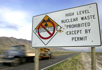 The Australian Government’s preferred site for Nuclear Waste
is Muckaty Station, near Tennant Creek,
trucked from Lucas Heights, Botany and Hunters Hill through the Blue Mountains.
The Australian Government’s preferred site for Nuclear Waste
is Muckaty Station, near Tennant Creek,
trucked from Lucas Heights, Botany and Hunters Hill through the Blue Mountains.
.
In 1997, a train carrying 180 tonnes of high-level nuclear waste derailed in France. In 2004, a truck spilled strontium-90 onto Highway 95 in Roane County, Tennessee.
.
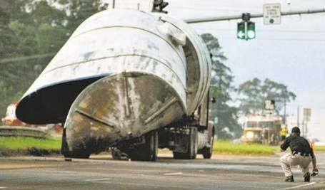
She’ll be Right!
.
America 2011:
.
<< With the passage of Senate Bill 1504 in the Texas Senate (Texas Low-Level Radioactive Waste Disposal Compact) , radioactive waste could soon be barreling down Texas highways and through our neighborhoods by way of Interstate 10 through Houston, San Antonio and El Paso; Interstate-20 and Interstate-30 though Dallas and Forth Worth, Midland and Odessa ; and Interstate-27 though Lubbock and Amarillo.
The greatest risk we face is having an accident with vehicles containing waste. Cleanup estimates range from $100 to a billion dollars or more according to the U.S. Department of Energy, but the state of Texas has set aside only $500,000. Taxpayers would pay the rest.
And what if an accident happens next to a school, playground or hospital? Don’t we want to make sure that our local emergency responders have the training and equipment needed to handle an accident where a truck is leaking radioactive waste?
Thanks to Senator Seliger’s leadership, there have been some important protections added in, but a number of loopholes remain that dramatically increases the risk and liability assumed by Texas taxpayers. There is still a chance to close these loopholes. This bill goes to the Texas House floor next week and Texans should ask their legislators to make sure that there is an immediate thorough analysis of transportation risks, costs of cleaning up contamination from accidents or leaks, and waste capacity at the site.
As the Japanese nuclear disaster has taught us, cleaning up after radioactive waste can be a costly and dangerous process. We urge the house to make sure we have protective measures in place before an accident. >>
.
[Ed: The Texas Senate Bill 1504 was made effective 9th January 2011]
.
[Source: Radioactive Waste Could Be Rumbling Through Your Town Unless State Legislators Close Loopholes in SB 1504, 20110414, by Citizen Carol,
^http://texasvox.org/2011/04/14/radioactive-waste-could-be-rumbling-through-your-town-unless-state-legislators-close-loopholes-in-sb-1504/]
.
Tags: B-Double Trucks, Blue Mountains, Chemtrans, Great Western Highway, Greater Blue Mountains World Heritage Area, Muckaty, National Radioactive Waste Management Bill 2010, nuclear waste, Radioactive Waste Dump, Ron Finemores Transport, Scott Corporation, trucking expressway, Trucking nuclear waste
Posted in Threats from Pollution, Threats from Road Making | No Comments »
Add this post to Del.icio.us - Digg
Leave a Reply
You must be logged in to post a comment.
|
|
")
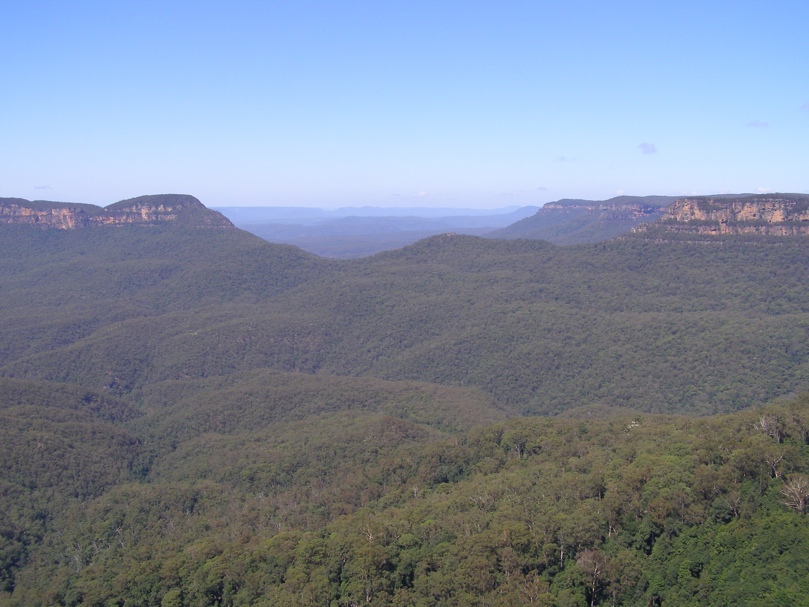


Get your facts straight. Katoomba Golf Club has been 18 holes for nearly 100 years. The houses that were built were constructed on land that was already part of the course. To say the club destroyed bushland so they could expand is totally incorrect.
Jim,
You’re not the only one rather nit picking incidentals in this article; while we are somewhat disappointed that you have ignored its main messages.
Our source of the Katoomba Golf Club in fact being a 9 hole course comes from the club’s official website on its history page, which for your benefit we reproduce its text below. That history only extends up to 1923, 90 years ago. No history since is mentioned. So if yours or anyone else’s records are more accurate/subsequent than the official website, then raise this with club management.
We have received further material that relates to the bulldozing of surrounding bushland around the club since the early 1990s relating to The Escarpments townhouses development, but also the extension/creation of fairways and greens into the bush. We will publish a follow up article shortly, given the special interest.
Constructive feedback from readers is appreciated and we aim to be factual in what is published.
Thank you for your interest.
Ed.
“History
1911 The formation of the Municipal Golf Links came before Council in July.
1913 Land selected by South Katoomba Land Co. Permission sought to close certain roads for the construction of a 9 hole golf course.
1917 Approach was made to Council in May to take over the designated area. Offer was declined. Another approach was made in August and was again declined.
1918 Another approach was made in February and was declined yet again. Council finally accepted the proposal in October with ammended conditions.
1919 Council valued the land at £1500 and the transfer was made in August. The South Katoomba Land Co had expenses of £3300 for clearing and contouring the site.
1921 Interested citizens from the Municipality of Katoomba approached Council to form a Golf Club.
1922 Katoomba Golf Club was inaugrated in January with the promise by Council to back the club with £1 for every £1 raised.
1923 Council appointed a groundsman to work under the direction of the Golf Committee.
On May 5th, the Mayor of Katoomba, Alderman W.Rumble officially opened the 9 hole course.”
[Source: http://www.katoombagolf.com.au/members/history/%5D
It is sad to say that people are nit picking when the writer’s main message are based on a faulty platform.
Whilst Katoomba Golf Club’s historian states a 9 hole course was opened in 1923, the fact that he does not document when the course became an 18 hole course does not excuse the writer from the sloppy research carried out for his/her article.
The writer bases his/her main messages on the the assumption that the course was converted to an 18 hole course in the 1990s. A little research would show how wrong this assumption is. The additional 9 holes were in place in the 1950s. (Source Documents – Katoomba Golf Club journals)
The golf club was re-developed during the early to mid 1990s. During this time some of the 9 holes were not used.
I am sure any member of Katoomba Golf Club would willingly show you the changes that were made to the course.
Could I refer you to the minutes of the Council’s Meeting held on 27 April 2012 (P62)? This will help clear up some of the faulty assumptions in the article.
John and Jim,
We have since publication of this article received material showing that the golf course was expanded to 18 holes circa 1927. The development works commencing in the mid-1990s relate to expansion of the course acquiring 5.6 hectares of community zoned woodland alongside Narrow Neck Road in order to build 13 townhouses and a resort hotel. Also circa 2007, a fairway/green was extended into bushland near Stuarts Road.
We have now noted this as a corrigendum in the article’s text.
We have also received considerable details about the development and council involvement, which we shall collate as follow up articles.
Ed.
Hi
Ed.
I am pleased to see your modifications to the text as they clarify some of the issues that I saw as being clearly wrong.
The point that you raise regarding the acquisition of 5.6 hectares of community zoned land woodland surprises me. Would you be able to give me your source for this as I understood from my readings of Council documents and discussions with golf course members that existing fairways was proposed/used for the units.
I also thought that the resort was to be built on the golf course. Perhaps I am wrong there.
Thanks
John C.
Hello John,
We shall be running subsequent articles on this issue in due course, including the background concerning The Escarpments development.
In the interim, according to our sources, you may obtain the development information from the delegated authority, Blue Mountains Council – the relevant DA being X98/0905, or X/905/198/E.
Ed.
Your article continues to be misleading. It still reads as though the course was expanded to 18 holes in the 1990’s. And that is simply not true. Was any follow up article ever published on this topic?
We have all the history of the dodgy deals over the years between council and the developer. It will be published in its entirety in due course.