Posts Tagged ‘Barry O’Farrell’
Friday, June 14th, 2013
 Longwall Mining is permanently destroying to rivers of the Illawarra.
Waratah Coal, owned by Clive Palmer, wants more mining there. Longwall Mining is permanently destroying to rivers of the Illawarra.
Waratah Coal, owned by Clive Palmer, wants more mining there.
.
Waratah Rivulet is a stream that is located just to the west of Helensburgh (55km south of Sydney) and flows into the Woronora Dam. Along with its tributaries, it makes up about 29% of the Dam catchment.
The Dam provides both the Sutherland Shire and Helensburgh with drinking water. The Rivulet is within the Sydney Catchment Authority managed Woronora Special Area.
There is no public access without the permission of the SCA. Trespassers are liable to an $11,000 fine. Yet mining companies are authorised to destroy complete river systems.
.
Longwall Mining under Waratah Rivulet
.
<<Metropolitan Colliery operates under the Woronora Special Area. Excel Coal operated it until October 2006 when Peabody Energy, the world’s largest coal mining corporation, purchased it. The method of coal extraction is longwall mining.
Recent underground operations have taken place and still are taking place directly below the Waratah Rivulet and its catchment area.
In 2005 the NSW Scientific Committee declared longwall mining to be a key threatening process. The Waratah Rivulet was listed in the declaration along with several other rivers and creeks as being damaged by mining. No threat abatement plan was ever completed.
In September 2006, conservation groups were informed that serious damage to the Waratah Rivulet had taken place. Photographs were provided and an inspection was organised through the SCA to take place on the 24th of November.
On November 23rd, the Total Environment Centre met with Peabody Energy at the mining company’s request. They had heard of our forthcoming inspection and wanted to tell us about their operation and future mining plans. Through a PowerPoint presentation they told us we would be shocked by what we would see and that water had drained from the Rivulet but was reappearing further downstream closer to the dam.
The inspection took place on the 24th of November and was attended by officers from the SCA and DEC, the Total Environment Centre, Colong Foundation, Rivers SOS and two independent experts on upland swamps and sandstone geology.
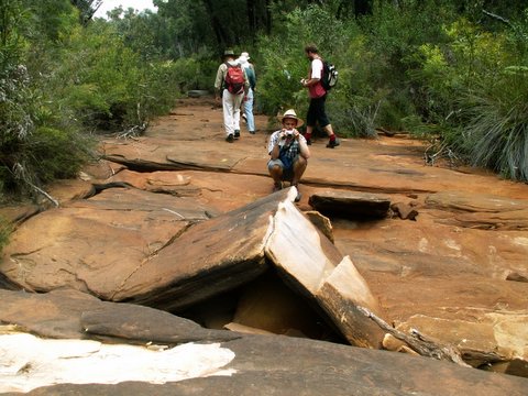
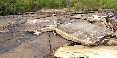
We walked the length of the Rivulet that flows over the longwall panels. Although, similar waterways in the area are flowing healthily, the riverbed was completely dry for much of its length. The cracking of the sandstone streambed caused is typical of that caused by longwall mining in the Southern Coalfield. The SCA officers indicated that at one series of pools, water levels had dropped about 3m. We were also told there is anecdotal evidence suggesting the Rivulet has ceased to pass over places never previously known to have stopped flowing.
The whole watercourse, where the coal has been extracted by the longwall machine, has tilted to the east as a result of the subsidence and upsidence. Rock ledges that were once flat now sloped. Iron oxide pollution stains in the streambed were also present. The SCA also told us that they did not know whether water flows were returning further downstream. There was also evidence of failed attempts at remediation with a distinctly different coloured sand having washed out of cracks and now sitting on the dry river bed or in pools.
Also undermined was Flat Rock Swamp at the southernmost extremity of the longwall panels. It is believed to be the main source of water recharge for the Waratah Rivulet. It is highly likely that the swamp has also been damaged and is sitting on a tilt.
The longwall panels that have damaged the river are LW 8-13. These pre-dated the new approvals process that came into force in 2004. A Subsidence Management Plan for LW 14-17 was recently approved by the DPI and LW 14 is currently being mined. The SMP states that land above LW 8-13 had subsided about 1.3m on average and that there has been no significant impact upon net flow or water quality.
The Total Environment Centre has applied under FOI legislation to the SCA for documents that refer to the damage to the Waratah Rivulet.
During the meeting with Peabody on 23rd November, the company stated its intentions sometime in 2007 to submit a 3A application under the Environmental Planning &Assessment Act 1974 to extract a further 27 longwall panels that will run under the Rivulet and finish under the Woronora Dam storage area.
This is very alarming given the damage that has already occurred to a catchment that provides the Sutherland Shire & Helensburgh with 29% of their drinking water. The dry bed of Waratah Rivulet above the mining area and the stain of iron oxide pollution may be seen clearly through Google Earth.>>
.
 Damaged: Cracked rocks along the Waratah Rivulet
[Source: Photo by Peter Turner, 20120528
^http://www.theleader.com.au/story/266961/fears-for-ruined-water-source/] Damaged: Cracked rocks along the Waratah Rivulet
[Source: Photo by Peter Turner, 20120528
^http://www.theleader.com.au/story/266961/fears-for-ruined-water-source/]
.
Longwall Mining under or close to Rivers and Streams
.
<<Seven major rivers and numerous creeks in NSW have been permanently damaged by mining operations, which have been allowed to go too close to, or under, riverbeds. Some rivers are used as channels for saline and acid wastewater pumped out from mines.
Many more are under threat. The Minister for Primary Industries, Ian Macdonald, is continuing to approve operations with the Department of Planning and DEC also involved in the process, as are a range of agencies (EPA, Fisheries, DIPNR, SCA, etc.) on an Interagency Review Committee. This group gives recommendations concerning underground mine plans to Ian Macdonald, but has no further say in his final decision. A document recently obtained under Freedom of Information rights by Rivers SOS shows that an independent consultant to the Interagency Committee recommended that mining come no closer than 350m to the Cataract River, yet the Minister approved mining to come within 60m.
The damage involves multiple cracking of river bedrock, ranging from hairline cracks to cracks up to several centimetres wide, causing water loss and pollution as ecotoxic chemicals are leached from the fractured rocks. Aquifers may often be breached. Satisfactory remediation is not possible. In addition, rockfalls along mined river gorges are frequent.
The high price of coal and the royalties gained from expanding mines are making it all too tempting for the Iemma (Labor NSW) Government to compromise the integrity of our water catchments and sacrifice natural heritage.>>
.
.
Longwall Mining in the Catchments
.
<<Longwall coal mining is taking place across the catchment areas south of Sydney and is also proposed in the Wyong Catchment.
A story in the Sydney Morning Herald in January 2005 stated that the Sydney Catchment Authority was developing a policy for longwall coal mining within the catchments that would be ready by the middle of that year. This policy is yet to materialise.
The SMP approvals process invariably promises remediation and further monitoring. But damage to rivers continues and applications to mine are approved with little or no significant conditions placed upon the licence. Remediation involves grouting some cracks but cannot cover all of the cracks, many of which go undetected, in areas where the riverbed is sandy for example. Sometimes the grout simply washes out of the crack, as is the case in the Waratah Rivulet.
The SCA was established as a result of the 1998 Sydney water crisis. Justice Peter McClellan, who led the subsequent inquiry, determined that a separate catchment management authority with teeth should be created because, as he said “someone should wake up in the morning owning the issue” of adequate management.
An audit of the SCA and the catchments in 1999 found multiple problems including understaffing, the need to interact with so many State agencies, and enormous pressure from developers.
Developers in the catchments include mining companies. In spite of government policies such as SEPP 58, stating that development in catchments should have only a “neutral or beneficial effect” on water quality, longwall coal mining in the catchments have been, and are being, approved by the NSW government. Overidden by the Mining Act 1992, the SCA appears powerless to halt the damage to Sydney’s water supply.>>
.
[Source: ‘Waratah Rivulet – The death of a river system from mine subsidence’, by Australian Coal Alliance, ^http://australiancoalalliance.com/waratah_rivulet.htmhttp://australiancoalalliance.com/waratah_rivulet.htm]
.
Clive Palmer’s Waratah Coal
.

.
<<Waratah Coal is an exploration and coal mine development company which is a wholly owned subsidiary of Mineralogy Pty Ltd.
Formed in 2005 and based in Brisbane, Waratah Coal is focused on the exploration and development of coal projects in Australasia. Along with another Mineralogy subsidiary, Galilee Pty Ltd, Waratah Coal proposes an $8 billion coal mine and infrastructure project in the Galilee Basin in Central Queensland.
The Galilee Coal Project includes a large scale thermal coal mine near Alpha, west of Emerald. The complex will include four underground mines, two surface mines and associated coal handling and processing facilities. The mine will be linked to a new coal terminal at Abbot Point near Bowen by a new 471km standard gauge, heavy haul railway line.
The Galilee Project and Waratah’s Galilee Power project have both been granted ‘significant project’ status by the Coordinator-General of Queensland in November, 2008, and September, 2009, respectively.
After being listed on the Toronto Stock Exchange and later the Australian Stock Exchange, Waratah Coal in December, 2008, accepted an offer from Mineralogy Pty Ltd for a controlling stake in the company.
Waratah Coal became part of the Mineralogy Group and the company is 100 per cent owned by Mineralogy Pty Ltd. The Mineralogy Group and associated entities have 25 years’ experience developing, managing, and funding a range of major projects. Mineralogy Group has a current market capitalisation of approximately $11 billion.
The Group currently employs around 2,200 Queenslanders in its activities in the state. Through its diversified interests (which includes the $6 billion Yabulu Nickel refinery in Townsville, oil and gas exploration in Papua New Guinea and the $5 billion Sino Iron magnetite iron ore development in Western Australia) the Group has formed major international alliances in China and domestically.>>
.
[Source: Waratah Coal, ^http://www.waratahcoal.com/corporate-profile.htm]
.
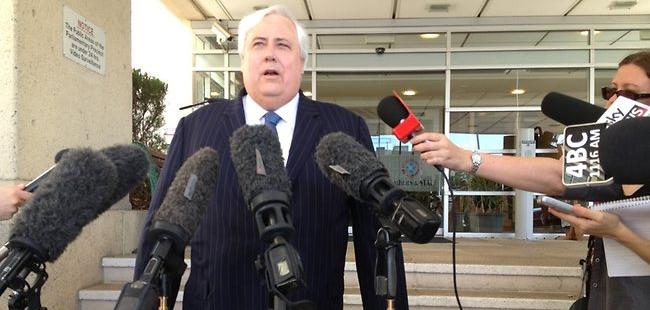
Waratha Coal’s Executive Chairman, Clive Palmer
..
Mining Jobs, Jobs, Jobs?
.
<<Waratah Coal believes that outstanding staff are a vital key to its success as an organisation and is committed to providing a rewarding and challenging environment for its staff.
Current Roles available at Waratah Coal: “There are currently no positions available.”>>
.
 The Jamison Valley Landslide
Blue Mountains Mining Legacy of Katoomba Colliery The Jamison Valley Landslide
Blue Mountains Mining Legacy of Katoomba Colliery
.
.
Further Reading
.
[1] 2010: BHP Billiton threatens Dharawal Swamps and Rock Art
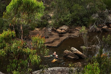 Possibly the cleanest water in New South Wales
Cobong Swim Hole in O’Hares Creek in the Dharawal State Conservation Area
Photo by Kate Geraghty Possibly the cleanest water in New South Wales
Cobong Swim Hole in O’Hares Creek in the Dharawal State Conservation Area
Photo by Kate Geraghty
.
<<A vast new coalmine planned for Sydney’s south-western outskirts will damage the city’s natural desalination plant – the ”hanging swamps” that filter pure water down into the Georges River.
More than 50 swamps in the little-known Dharawal State Conservation Area, south-east of Campbelltown, will be undercut by longwall coalmines, which the mine owner, BHP Billiton, admits are likely to crack the bedrock and drain swamps. Aboriginal rock art above the mine site is also at risk.
The proposal, being considered by the NSW Government, calls for a huge expansion of existing coalmines near Appin, which would lock in mining there for 30 years.Opposition to the plan is growing, and a coalition of local residents and environment groups and the National Parks Association are calling for mining to be excluded from the conservation area.
”It is literally underground and metaphorically under the public radar,” said Sharyn Cullis of the Georges River Environmental Alliance. ”There should be widespread outrage or, at the very least, public debate about whether we really want the landscape desiccated … sacrificed for the sake of coal.
”The hanging swamps are shallow sandstone bowls, packed with matted sedge, native grasses and banksias that act like a sieve and a sponge, holding water in dry times and allowing it to seep out and feed some of the state’s cleanest creeks.
”I would rather they mined under my own house than in the conservation area,” said Julie Sheppard, of environment group Rivers SOS, whose home lies above another planned longwall panel near Appin.
O’Hares Creek, which flows through the conservation area and provides more than two-thirds of the water to the Georges River, is itself fed by the swamps.
”A total of 226 swamps have been identified within the entire Bulli seam project area, of which the Dharawal State Conservation Area is a part,” a BHP Billiton spokeswoman said in a statement.
”There is some potential for impact but a monitoring and management plan has been developed.
”The company said its plans had been designed to minimise impact on larger rivers.”Illawarra Coal has not mined directly beneath rivers since 2002, and consistent with this commitment, we have positioned longwalls away from major rivers and streams in the Bulli seam project.
”A detailed study by the staff at the NSW Department of Environment and Climate Change found the swamp network to be a ”priority fauna habitat” for several endangered species, including the ground parrot and the giant burrowing frog.
The area also contains dozens of Aboriginal sites.”Once you take the coal away, there’s nothing to support the sandstone, and our artwork is cracking,” said Alan Carriage, an elder of the Wadi Wadi people.
A June 2009 report produced by Biosis Research for BHP Billiton found that 11 Aboriginal rock art sites in the southern coalfields had already been damaged by subsidence from longwall mining. But hypocritically and consistent with darkside consultants who will say anything for a buck concluded that “overall there is a low risk of significant impact to Aboriginal cultural heritage values”.
Before damaging a recognised Aboriginal site, a mining company must obtain a “permit to destroy” under the NSW heritage protection system. However Bev Manton, of the NSW Aboriginal Land Council, dismissed this process as a “regime to manage destruction”.
She said five permits allowing damage to Aboriginal heritage sites are being issued a week by the State Government, and called for a new regime that gives more power to Aborigines to protect their significant sites.>>
.
[Source: ‘Mining ‘threat to swamps and rock art’, 20100130, Ben Cubby with Andrew Small, Sydney Morning Herald, ^http://www.smh.com.au/environment/mining-threat-to-swamps-and-rock-art-20100129-n48w.html]
.
.
[2] 2012: Apex Energy’s coal seam gas threatens Sydney’s drinking water
.
<<A coal seam gas company’s bid to save its Illawarra exploration project has triggered a flood of community opposition and again raised fears about mining in the water catchment.
Apex Energy’s approval for a 16-borehole exploration project around Darkes Forest and Maddens Plains expires tomorrow.
Planning authorities are now considering its application to extend the expiry date for three years after the first borehole is drilled, effectively allowing an indefinite extension as no start date is listed.
Despite the fact the project itself has not changed, the application generated 129 public submissions plus another 16 from groups including Stop CSG Illawarra and the National Parks Association.
Last year, Apex’s application for the 16th borehole received 1045 submissions from the public. The scrutiny reflects the depth of community concern about environmental risks linked to CSG, and the political heat the O’Farrell government faces over it.
By comparison, coal company Gujarat NRE’s application to expand its mine and open a new longwall beneath the water catchment only received 23 public submissions and two from interest groups.Stop CSG Illawarra spokeswoman Jess Moore put the difference down to greater community awareness about Apex’s project and its threat to the catchment.‘‘It’s outrageous that I can be fined up to $44,000 for walking in the catchment yet the government will allow CSG development in that area,’’ she said.Gujarat’s proposal faced harsher criticism from government agencies than Apex’s, which is located partly in the water catchment and is still at the exploration stage.Further approvals would be required before production.Wollongong City Council opposed Apex’s time extension, saying even with stringent environmental controls it would be hard to argue CSG activities would have only a neutral or beneficial effect.The Office of Environment and Heritage said it would be ‘‘unlawful’’ to drill the three proposed boreholes in the national park.Apex’s application said more than 10,000 boreholes had been drilled in the southern Sydney basin during the Illawarra’s long mining history, but only 50 exploration boreholes had been drilled by the coalmining industry in the timeframe they had followed.An independent panel will determine the application. A spokesman for Planning Minister Brad Hazzard said the government’s new Strategic Regional Land Use Policy applied Australia’s ‘‘toughest protections and regulations’’ to CSG mining. .
[Source: ‘ Opposition grows to coal seam gas bid in Sydney’s drinking water catchment’, 20120921, ^http://coalseamgasnews.org/news/world/australia/nsw/opposition-grows-to-coal-seam-gas-bid-in-sydneys-drinking-water-catchment/]
.
.
[3] 2012: Peabody Energy’s Longwall Mining irreversibly cracking riverbed – government turns a blind eye
.
<<Sutherland Shire (New South Wales) environmentalists are calling on Peabody Energy to release information on the state of the Waratah Rivulet, which supplies drinking water to the Woronora Dam. They claim the company has failed to divulge the success or failure of its attempts to remediate the damaged riverbed.
The rivulet, which is in the Woronora special area and off-limits to the public, first hit the news in 2007 when cracks were discovered in the riverbed and some its waters disappeared underground. The damage was blamed on longwall coal mining underneath the riverbed undertaken by the Peabody-owned Metropolitan Colliery.
The National Parks Association of NSW has released a video documenting a visit to the rivulet by a group of environmentalists and Greens MP Jeremy Buckingham six months ago.
It shows unremediated cracks, as well as some of Peabody’s remediation attempts.
Nationa Parks Association Southern Sydney Branch Secretary, Gary Schoer:
“No one has been able to find out if the damage to the rivulet was ongoing or if remediation was actually working. When we visited we found out the remediation is still proceeding,” Mr Schoer said. “We saw many cracks which had not yet been filled. But we don’t know how extensive the damage is, or how successful the remediation is. The NPA has been trying to meet with Peabody for the past six months.”
.
Peabody Energy, NSW Environment Minister Robyn Parker and NSW Primary Industries Minister Katrina Hodginkinson, who is responsible for the Sydney Catchment Authority have all declined to comment.
 Turning a blind eye
Katrina Hodginkinson Turning a blind eye
Katrina Hodginkinson
.
Georges River Environmental Alliance Secretary Sharyn Cullis, who visited the rivulet with Mr Schoer:
“What I saw on a tour of inspection, inside what is supposed to be a protected catchment, really horrified me.
The riverbed of the Waratah Rivulet was smashed. What should have been clear, clean water in the stream, which is 30 per cent of the inflow into the (Woronora) dam, was a murky orange brown. What should have been drinking water didn’t look fit for a dog to drink.
Remediation attempts so far appeared to be “futile”.
.
Gary Schoer said tests conducted by environmentalists had confirmed chemical changes to the water which flowed through the damaged areas of the rivulet, but said he did not know, and had been unable to find out, how much of this water was flowing into the Woronora Dam.
Should there be greater protection for the rivulet? >>
.
[Source: ‘Fears for ruined water source’, 20120528, by Kate Carr, The Leader newspaper, St Georgeand Sutherland Shire, ^http://www.theleader.com.au/story/266961/fears-for-ruined-water-source/]
.
.
[4] 2013: BHP Billiton’s Illawarra Longwall Coal Mine threatens stream subsidence
.
 Ed: In what? Ed: In what?
.
<<An Illawarra Coal mine plan could cause significant cracking in parts of the Upper Nepean swampland leading to surface water loss, a Sydney Catchment Authority submission states.
The bulk of Macarthur’s drinking water is sourced from these catchments, where Illawarra Coal is proposing to operate a new underground coalmine, seven kilometres west of Port Kembla.
In its submission to the Planning Department, the Sydney Catchment Authority said: “Significant cracking is predicted that would lead to diversion of surface stream flow . . . resulting in surface water loss.”
An Illawarra Coal spokeswoman said BHP Billiton had been successfully mining at Dendrobium without any significant environmental impacts since the NSW Government approved mining in the area in 2001.
“Illawarra Coal has modified its mine plan to avoid significant impacts to key environmental features in the area such as Avon Dam and Wongawilli Creek,” she said.
“Illawarra Coal has developed a mine plan which has our longwall blocks positioned well away from the full supply level of Avon Dam and several kilometres away from the dam wall. We have no evidence of impacts to the dam.”
The National Parks Association has expressed fears Macarthur’s water catchments are under threat from the mine plan and called for a “rejig” of the longwall layouts to avoid damaging the swampland.
Illawarra Coal was granted conditional approval for the Dendrobium project in 2001 but is now seeking approval for its subsidence management plan to move into Area 3B.
National Parks Association spokeswoman Julie Sheppard said measures should be put in place to avoid harming an important part of the catchment.
The Sydney Catchment Authority, in its submission, recommends more stringent conditions be placed on the subsidence management plan.
The NSW Department of Urban Affairs and Planning says the Dendrobium project expects to extract 5.2 million tonnes of coal a year over 21 years. It also said the project expected to provide up to 261 full-time construction jobs and up to 277 direct jobs during the operational time.>>
.
[Source: ‘Swampland ‘at risk’, 20130122, by Michael Cox, journalist with Wollondilly Advertiser, ^http://www.wollondillyadvertiser.com.au/story/1250517/swampland-at-risk/]
.
.
[5] Rivers SOS
.
In 2005, Rivers SOS (a coalition of 30 groups) formed with the aim of campaigning for the NSW Government to mandate a safety zone of at least 1km around rivers and creeks threatened by mining in NSW. The peak environment groups of NSW endorse this position and it forms part of their election policy document.Rivers SOS, ^http://riverssos.org.au/
.
[6] Stop CSG Illawarra
.
.
[7] Coal Seam Gas News
.
<<The purpose of CoalSeamGasNews.org is to provide quick access to Coal Seam Gas mining news, research, forums and public meeting schedules, provide a voice for the many Australians who want a sustainable mining industry, and to help people get the facts – not myths – about the Coal Seam Gas industry. ^http://coalseamgasnews.org/
.
.
[8] Australian Coal Alliance
^http://australiancoalalliance.com/main.htm
.
.
 . .
.
Tags: Barry O'Farrell, Clive Palmer, Dharawal State Conservation Area, Ian Macdonald, Illawarra Coal, Katrina Hodginkinson, long wall coal mining, Metropolitan Colliery, O'Hares Creek, Peabody Energy, Subsidence due to longwall mining, Waratah Coal, Waratah Rivulet, Woronora Special Area, Wyong Catchment
Posted in Threats from Mining | 2 Comments »
Add this post to Del.icio.us - Digg
Sunday, May 26th, 2013
 Ada Ma Way! Ada Ma Way!
.
The New South Wales Government’s dictatorial roads department, the RTA-come-RMS, has again kowtowed to the trucking lobby by deciding in its infantile wisdom to remove centre double lines from the Hawkesbury Road through the Blue Mountains west of Sydney, so that big sand trucks with trailers (basically ‘B-Doubles‘) can hog both sides of the highway.
 Looka Me Looka Me Looka Me! Looka Me Looka Me Looka Me!
.
The idiots in the fancy new RTA-come-RMA headquarters in Parramatta want no restrictions on truck-length, no speed restrictions for these trucks along Hawkesbury Road – the bigger trucks the better, God Damn!
.
 Strategy to avoid a B-Double
An Outback vernacular joke, not so funny… Strategy to avoid a B-Double
An Outback vernacular joke, not so funny…
.
 Outback Crash
Often the End of Everyone’s Story! Outback Crash
Often the End of Everyone’s Story!
.
It’s a Northern Territory Outback Approach – unlimited speed and road trains – despite Hawkesbury Road winding tightly down the mountain at Hawkesbury Heights and passing through residential areas between Springwood and Richmond.
.
Winmalee ain’t trucking Tennant Creek!
.
 . .
According to Hawkesbury Road residents typically 90 tipper trucks with dog trailers (basically B-Doubles) hoon along the road daily.
 . .
In late 2012, the RTA-come-RMS removed the centre line marking on four hairpin bends at Hawkesbury Heights so that bigger trucks can cross the center of the road without crossing over centre double lines because the double lines have been painted over.
No centre lines, no road centre, see, just like Mount Panorama! No speed cameras, no police patrols, speeding cowboy truckers out of control. Car, motorbike and pedestrian traffic are just collateral damage.
 Bugger! Bugger!
Truck rollover along Mill Road at Kurrajong in the Blue Mountains
Cowboy Trucker going too fast – nuh.
[Source: Photo by Top Notch Video, in article ‘Lucky Easter accident escape’, 20120412, by Cerise Burgess, journalist, Hawkesbury Gazette, ^http://www.hawkesburygazette.com.au/story/273890/lucky-easter-accident-escape/]
.
The local Blue Mountains Council has rightly branded the RTA-come-RMS decision to remove these double centre lines as “absolutely insane”‘, “ridiculous” and “plain criminal” at its councillor meeting on 23rd April 23 2013. Councillor Brendan Christie stated, “I just think it is completely ridiculous that six bureaucrats from the RMS sat down for a nice lunch and this is all they could come up with.”
 Blue Mountains Council’s delegated Local Traffic Committee: Minutes of Meeting 20130326 Blue Mountains Council’s delegated Local Traffic Committee: Minutes of Meeting 20130326
.
Two years ago in 2011, the Blue Mountains Council reported on a Road Safety Action Plan. The report identified that:
<<the Blue Mountains has almost triple the amount of speed related crashes than the Sydney Region. Our rate of 33.73% is almost double that of the rate of NSW. This makes reducing speeding on our roads a clear road safety priority for the Blue Mountains community.>>
 . .
The report also identified trucks as a key issue:
<<The Blue Mountains has a significantly higher proportion of trucks involved in crashes than the Sydney Region, Western Sydney or NSW.
Over a five year period, light trucks constituted 9.53% of crashes in the Blue Mountains. This can be compared with 7.85% in Sydney, 8.31% in Western Sydney and 8.67% in New South Wales as a whole. The Blue Mountains also experienced significant increases in crashes involving trucks over the last five years.>>
.
.
Yet at the same time, the Blue Mountains Council is similarly embracing more trucks transiting through Blue Mountains by planning a new truck route through native bushland habitat and over the headwaters of Fitzgerald Creek and carved through critically endangered Sydney Turpentine Ironbark Forest in protected Deanii Reserve.
 Example of a Sydney Turpentine Ironbark Forest
[Source: ^http://www.georgesriver.org.au/Riverkeeper-Photo-Gallery.html] Example of a Sydney Turpentine Ironbark Forest
[Source: ^http://www.georgesriver.org.au/Riverkeeper-Photo-Gallery.html]
.
The Council has already spent $77,000 on a study to consider possible route options for a truck link road between Hawkesbury Road and the Great Western Highway at Valley Heights. The preferred route necessitates massively increasing the road weight limit, creating a two-lane, three-span bridge 35 metres above Fitzgerald Creek with a total the project construction cost of $26 million, all to encourage more trucks through the Blue Mountains.
Borrowing the same mealy-mouthed spin as the RTA-come-RMS, the Council’s consultants try to justify the new road would “improve traffic flow and reduce delays.” No doubt its environmental impact statement would be conjured up by darkside ecologists to pretend the road works and bridge works would cause minimal impact to endangered ecology.
The initial council study will go on public exhibition soon with a report back to council in August 2013. We shall be ready to rip the EIS apart, or will it be watered down to another Review of Environmental Effects as per usual?
.
[Source: ‘Springwood link road plan’, 20130508, by Shane Desiatnik, journalist, Blue Mountains Gazette, ^http://www.bluemountainsgazette.com.au/story/1486914/routes-named-for-springwood-link-road-plan/]
.
 Truck rollover in the Blue Mountains April, 2005
RTA-come-RMS is giving tacit approval for truckers to use excessive speed and ignore common safety measures. Truck rollover in the Blue Mountains April, 2005
RTA-come-RMS is giving tacit approval for truckers to use excessive speed and ignore common safety measures.
.
The RTA-come-RMS is the handmaiden to the truck industry and has allowed Hawkesbury Highway to become a trucking cowboy corridor.
The Bells Line of Road is just a bad:
 . .
Somewhere in the Blue Mountains there is a truck collision or rollover a week. The trucking menace is out of control and these are the bureaucrats responsible – New South Wales Premier Barry O’Farrell and his Roads Minister Duncan Gay.
 Premier Barry O’Farrell (left) and Roads Minister Duncan Gay
Handmaidens of Trucking Premier Barry O’Farrell (left) and Roads Minister Duncan Gay
Handmaidens of Trucking
.
Local residents and ordinary users of the Hawkesbury Road are intimidated by these trucking cowboys speeding, hogging the road and tailgating like their on a speedway circuit.
 Blackheath, Blue Mountains, already a statistical victim
Betty Dowdell of Blackheath, 16 Dec 2008, rest in peace
Your memory is not lost. Blackheath, Blue Mountains, already a statistical victim
Betty Dowdell of Blackheath, 16 Dec 2008, rest in peace
Your memory is not lost.
.
Drivers on the bends of Hawkesbury Road have raised concerns about the serious risks of heavy vehicles crossing to the wrong side of the road as they negotiate the narrow corners. The Roads and Maritime Service removed the centre lines on the bends late last year which residents say has only increased the problem.
 Trucker Wet Dreaming Trucker Wet Dreaming
.
With four schools on the 10km road, driver safety is paramount both on the Winmalee stretch and also for those people driving down from the Mountains via the bends. According to local politicians, the solution would be for a proper review of the road by the RTA-come-RMS, with a view to enforcing the road rules, including a return to the centre lane markings on the bends and looking at other engineering options.
But many local residents have had enough and are demanding a complete ban trucks from driving on Hawkesbury Road which would mean it would no longer be gazetted as a State Route.
.
Barry, unhitch from the greedy Trucking Lobby
Support the safety concerns of Residents
 No Articulated Trucks on Hawkesbury Road No Articulated Trucks on Hawkesbury Road
No Trucking Shortcuts!
.
[Source: ‘Hawkesbury Road residents driven round the bend’, 20130424, by Damien Madigan, editor, The Blue Mountains Gazette, ^ http://www.bluemountainsgazette.com.au/story/1454002/hawkesbury-road-residents-driven-round-the-bend/]
.
 Kredies Trucking speeding down Victoria Pass, 5th December 2011 Kredies Trucking speeding down Victoria Pass, 5th December 2011
.
<<A truck driver has been airlifted to hospital with suspected spinal injuries, and a major cleanup operation has been undertaken following a truck overturning on Mount Victoria Pass this afternoon (5 December 2011).
Emergency Services were called to the bottom of Mount Victoria Pass (Great Western Highway) just after 2:30pm today following reports an eastbound semi-trailer carrying scrap metal had rolled onto the concrete divider, leaving the driver trapped in the cabin.
Several Fire and Rescue NSW crews, Police Rescue, an Ambulance and a rescue helicopter responded to the scene. Rescue crews freed the driver about 4:45pm before he was airlifted to hospital suffering suspected spinal injuries.
The Great Western Highway has been closed for several hours while a clean up and salvage operation is underway with debris scattered across the roadway. The RTA has advised traffic is being diverted into the Darling Causeway with eastbound motorists being advised to use Chifley Road (Mort St) and the Darling Causeway as an alternative route.>>
.
[Source: ‘Truck Overturns at Mount Victoria’, 20111205, by NSW Incident Alerts, ^http://news.nswincidents.com/2011/12/05/traffic/persons-trapped/truck-overturns-mount-victoria/]
.
 Speeding Truck Overturns down Mt Victoria Pass, 3rd August 2011
Two truckers dead
The pass has been there and steep for a long time – nothing new. Speeding Truck Overturns down Mt Victoria Pass, 3rd August 2011
Two truckers dead
The pass has been there and steep for a long time – nothing new.
.
<<Two men have been crushed to death inside the cabin of a truck in the Blue Mountains today. Police said the truck rolled and crashed into a barrier on the Great Western Highway, near the top of Victoria Pass, just after 10am. The two men were found dead inside the cabin. Their ages are unknown. One eastbound lane of the highway is expected to be closed for some time while police investigate.>>
.
[Source: ‘Two killed in Blue Mountains truck crash’, 20110803, by Georgina Robinson, Sydney Morning Herald, ^http://www.smh.com.au/nsw/two-killed-in-blue-mountains-truck-crash-20110803-1iaqu.html]
.
 It’s like the approach to Bagdad after Allied Forces’ Battle of Bagdad in 2003 It’s like the approach to Bagdad after Allied Forces’ Battle of Bagdad in 2003
[Source: ‘F3 accident outpost clears way for network of depots’, 20111027, Sydney Morning Herald,
^http://smh.drive.com.au/roads-and-traffic/f3-accident-outpost-clears-way-for-network-of-depots-20111026-1mk7i.html]
.
Footnote
.
Again, we didn’t have to wait long to learn about yet another dangerous trucking cowboy in New South Wales.
In Sydney’s outer north this morning, a truck side-swiped a school bus and didn’t stop.
The small school bus was travelling along Bay Road at 9 am at Berrilee, when the bus driver was forced to swerve to avoid a head-on collision with the truck over the centre lines.
In avoiding the collision, the bus driver scraped along a rockface alongside the left hand side of the narrow section of Bay Road. Four bus windows were smashed, and seven children on the bus suffered minor cuts from the smashed glass. Two of them were taken to hospital. The truck driver drove on (another hit and run) following the incident and yet police decided not to contemplate pursuing criminal charges.
Unbelievably the police are sight unseen self-excusing the trucker for ‘perhaps’ not realising the damage, because of some fabricated personal presumption that the truck was too big for the driver to notice. “We don’t think he even realised something had gone wrong” the police spokesman said.
Was this comment correctly reported by the media? If so, how does the police spokesman know? Does it take a child to die for these police to treat seriously the near fatality of children on a supposedly safe school bus?
If so, these police should state this presumption to the faces of the children’s parents and see what response they get for excusing dangerous trucking behaviour endangering the lives of their children.
If so, then these police are ignorant of what could have happened, of the likely trauma experienced by both bus driver and the children who will never forget this incident that could have ended their lives. These police seem to nonchalantly care nothing for road safety or for proactive policing.
‘She’ll be right reckless trucking‘ is unacceptable and here we record yet another trucking cowboy excused by police, until next time when an innocent road user is killed.
Not good enough!
.
[Sources: ‘Children injured in school bus crash at Berrilee in Sydney’, 20130529, ABC News, ^http://www.abc.net.au/news/2013-05-29/three-children-injured-in-school-bus-crash/4719814?§ion=news; and ‘Sydney school bus crash injures children, 20130529, by AAP, ^http://www.news.com.au/breaking-news/national/children-hurt-in-sydney-bus-crash/story-e6frfku9-1226652814870]
.
 2005: Another B-Double truck slammed into the rear of a school bus while speeding in fog at 8:30 am (school transit time) in country Victoria. About 20 primary school children were lucky not be killed as the back of a school bus was ripped off in the collision near Ballarat.
[Source: Photo by Craig Sillitoe, in article: ‘Bus crash students lucky to be alive’, 20050513, by Adam Morton, The Age, Victoria,
^http://www.theage.com.au/news/National/Bus-crash-students-lucky-to-be-alive/2005/05/13/1115843345721.html]
2005: Another B-Double truck slammed into the rear of a school bus while speeding in fog at 8:30 am (school transit time) in country Victoria. About 20 primary school children were lucky not be killed as the back of a school bus was ripped off in the collision near Ballarat.
[Source: Photo by Craig Sillitoe, in article: ‘Bus crash students lucky to be alive’, 20050513, by Adam Morton, The Age, Victoria,
^http://www.theage.com.au/news/National/Bus-crash-students-lucky-to-be-alive/2005/05/13/1115843345721.html]
.
Tags: Ada Ma Way, Barry O'Farrell, Bay Road, Berrilee, Blue Mountains, Blue Mountains Council, centre double lines, cowboy truckers, Duncan Gay, Hawkesbury Heights, Hawkesbury Road, Mill Road, Road Safety Action Plan, RTA-come-RMS, sand trucks with trailers, school bus, Springwood, State Route, Sydney Turpentine Ironbark Forest, tipper trucks with dog trailers, truck crash, trucking expressway, Winmalee
Posted in Blue Mountains (AU), Threats from Road Making | No Comments »
Add this post to Del.icio.us - Digg
Saturday, May 14th, 2011
In the north-western area of the Blue Mountains region of New South Wales (eastern Australia) lies the ancient Gardens of Stone. The area is so named because of its spectacular and rare sandstone rock formations known as ‘pagodas’ (large tapered, stepped or laminated sandstone formations) along with the abundance of native flora and fauna that thrive there.
Yet since November 2009, part of this beautiful pagoda country (some 1088 hectares of the Ben Bullen State Forest) with its important wildlife habitat, has come under threat of destruction from proposed open cut coal mining.
") Johnson’s Grass Trees on Genowlan Mountain
© Photo by Jaime Plaza van Roon
(click photo to enlarge) Johnson’s Grass Trees on Genowlan Mountain
© Photo by Jaime Plaza van Roon
(click photo to enlarge)
.
Gardens of Stone National Park
.
In 1994, a Gardens of Stone National Park was created covering 15,000 hectares and joining Wollemi National Park on the northern part of Newnes Plateau. Other large landscape features include the outstanding mesas of Donkey Mountain in the Wolgan Valley and Pantoneys Crown in the Capertee Valley. Pantoneys Crown was previously protected in a much smaller nature reserve, and is the centrepiece of the commanding view of the valley from Pearsons Lookout on the Castlereagh Highway.
 Pantoneys Crown, Gardens of Stone National Park, NSW
© Photo by David Braddon-Mitchell
[Source: ^http://dbm305.smugmug.com/Other/Pantoneys-Crown/13102823_B2fHx#950356269_VhEUF]
(click photo to enlarge) Pantoneys Crown, Gardens of Stone National Park, NSW
© Photo by David Braddon-Mitchell
[Source: ^http://dbm305.smugmug.com/Other/Pantoneys-Crown/13102823_B2fHx#950356269_VhEUF]
(click photo to enlarge)
.
Gardens of Stone Proposed Stage 2
‘But Gardens of Stone is an unfinished park. Environment groups, including Blue Mountains Conservation Society, have advanced a plan to protect much more of this unique landscape, by extending the park and creating a new state conservation area over adjacent plateaus and escarpments which are presently state forest and Crown land. The overall proposal is known as Gardens of Stone Stage 2, situated just north of the town of Lithgow. (The state conservation area classification allows underground coal-mining to continue.)
 [Source: ^http://www.bluemountains.org.au/gos2.shtml] [Source: ^http://www.bluemountains.org.au/gos2.shtml]
‘These unprotected areas are just as valuable as the existing park, and are rich in special environments such as pagodas and canyons, nationally endangered high altitude shrub swamps and an unusual heathland on Genowlan Mountain. Rare and threatened species include the beautiful yellow Pagoda Daisy, Deane’s Boronia, Blue Mountains Water Skink, Wolgan Snow Gum, Giant Dragonfly, Regent Honeyeater, Genowlan Pea and Beautiful Firetail. In the western parts of the area the moist mountain vegetation begins to give way to drier inland communities, including grassy box woodlands, one of the most diminished and threatened environments in Australia.
‘The Gardens of Stone Stage 2 provides one of the most beautiful displays of sandstone geodiversity in Australia, comprising dramatically coloured sandstone escarpments and promontories, narrow canyons, cave overhangs, swamps and the complex arrays of rock pinnacles known as pagodas. The area has one of the Blue Mountains’ areas of highest plant diversity including ancient windswept montane heathlands, nationally endangered upland swamps, a unique species of snowgum (E. gregsoniana) and other high plateau woodlands representing the highest development of native vegetation on Sydney Basin sedimentary rocks, poorly conserved grassy white box woodlands on slopes below the sandstone, fascinating oil shale mining ruins on spectacular Airly Mesa, and outstanding Aboriginal cultural sites on and around Newnes Plateau.
") Gardens of Stone
© Photo by Hamilton Lund, Tourism NSW
Blue Mountains – Visit NSW, ^http://www.visitnsw.com/destinations/blue-mountains (click photo to enlarge) Gardens of Stone
© Photo by Hamilton Lund, Tourism NSW
Blue Mountains – Visit NSW, ^http://www.visitnsw.com/destinations/blue-mountains (click photo to enlarge)
.
The area embraces the last unprotected part of the 1934 Greater Blue Mountains National Park proposal compiled by Myles Dunphy for the National Parks and Primitive Areas Council. It also includes the Blue Mountains Western Escarpment lands from Blackheath to Lithgow. The Gardens of Stone Stage 2 proposal advanced by The Colong Foundation for Wilderness, the Blue Mountains Conservation Society and the Colo Committee is to include all of the remaining parts of Newnes Plateau and surrounding sandstone uplands – an area of 40,000 hectares. It would protect the most spectacular pagoda landscapes in Australia.
Associated with these pagoda landforms are found large caves, mazes, ancient montane heathlands, endangered upland swamps, snowgums, grassy woodlands and moist gullies that contain tree ferns, stands of old growth forest and rainforest, and, in some places, slot canyons.
Reservation of Stage Two would also secure the outstanding ochre coloured cliffs of the Blue Mountains’ Western Escarpment and the rare plant communities that lie above them. Reservation of the remaining unprotected parts of the Gardens of Stone as a State Conservation Area is urgently required to rein in ongoing and accelerating environmental degradation.
[Sources: Gardens of Stone National Park, http://www.worldheritage.org.au/resources/national-parks/gardens-of-stone-national-park/ and Blue Mountains Conservation Society, http://www.bluemountains.org.au/gos2.shtml]
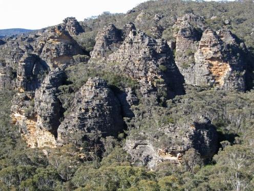 Pagodas of the Gardens of Stone (still outside the National Park) Pagodas of the Gardens of Stone (still outside the National Park)
© Photo by Andrew Valja
[Source: Blue Mountains Conservation Society, http://www.bluemountains.org.au/gos2.shtml]
(click photo to enlarge)
.
.
.

Threats from Coalpac Pty Ltd
.
CoalPac is a private Queensland coal mining company headquartered in Pullenvale in outer eastern Brisbane. In 1989, CoalPac took over coal mining operations outside the town of Lithgow in New South Wales, at the Cullen Valley Open Cut Mine and the Invincible Open Cut Mine. The Mines currently operate at 2 mtpa and Coalpac has plans for significant expansion of coal mines in the Gardens of Stone area.
 Coalpac’s CullenValley Mine
[Source: Lithgow Environment Group, Inc.]
(click photo to enlarge) Coalpac’s CullenValley Mine
[Source: Lithgow Environment Group, Inc.]
(click photo to enlarge)
.
‘Coalpac is seeking approval for the consolidation and expansion of the existing Cullen Valley Mine and Invincible Colliery operations to produce up to a total of 3.5 million tonnes per annum.’ [Source: http://cetresources.com/about-us]
This proposed extension of its open-cut and highwall mining will intrude into a large area of the publicly-owned Ben Bullen State Forest (BBSF), NSW. The extension area is equivalent of 2,176 football fields of predominantly old growth forest will be clear-felled and excavated if this goes ahead. The pagoda’s features and stability may be threatened by collapse.
 Cracked Hassans Walls, Lithgow ~ caused by nearby mining
[Source: Lithgow Environment Group, Inc.] Cracked Hassans Walls, Lithgow ~ caused by nearby mining
[Source: Lithgow Environment Group, Inc.]
.
“The NSW National Parks and Wildlife Service (now within the Office of Environment and Heritage) has acknowledged its wish to add BBSF to the conservation reserve system as a matter of priority” says Lachlan Garland, President of the Blue Mountains Conservation Society.
“Allowing this operation would mean the equivalent of 2,176 football fields of predominantly old growth forest of the BBSF being clear-felled and excavated.
“This forest is a publicly-owned area of conservation and recreational importance. The community expects state forests to be protected from destruction in perpetuity.
 ‘Baal Bone Creek’ area at risk
©Photo by Ian Brown.
‘Baal Bone and Long Swamp (7,800 hectares) comprise massed pagoda ‘villages’ above the Long Swamp, a diverse swampy plain. They collectively form an evocative landscape of broken stone, reminiscent of Cambodia’s forest of State Forest temples, while nearby indigenous cave art honours this landscape.’
(click to enlarge, then click again to enlarge further) ‘Baal Bone Creek’ area at risk
©Photo by Ian Brown.
‘Baal Bone and Long Swamp (7,800 hectares) comprise massed pagoda ‘villages’ above the Long Swamp, a diverse swampy plain. They collectively form an evocative landscape of broken stone, reminiscent of Cambodia’s forest of State Forest temples, while nearby indigenous cave art honours this landscape.’
(click to enlarge, then click again to enlarge further)
.
“Habitats for the Regent Honeyeater, Tiger Quoll and Powerful Owl and at least 32 threatened native animals, 5 of which are listed under the EPBC Act, will be completely removed.
“Our iconic Lyrebirds also use the sides of pagodas to nest and raise their young. Mining will completely remove the protective pathways for adult birds foraging between nesting sites and will destroy their food habitats within the more fertile valley floors.
“The effective privatisation and liquidation of a large part of the forest is an outrageous precedent that should not be set; it is a direct challenge to the state’s efforts to reduce deforestation.
“The Blue Mountains Conservation Society seeks to work with the Minister for the Environment and Heritage, Robyn Parker, to continue our important work and safeguard the future of the Gardens of Stone.
“We invite all politicians to visit the Gardens of Stone area with us on Sat 14th May, 2011 to see first hand the stunning areas under threat from mining.”
The NSW Department of Planning finalised the Director-General’s Requirements (guidelines) for the Environmental Assessment on 16 October 2010. The proponent is preparing the Environmental Assessment. Once finalised, this will be released for public comment. The project, prior to the election of the NSW Coalition Government, was to be assessed by an accredited process under Part 3A, which on 7th April 2011 was scrapped by the incoming O’Farrell Liberal Government of New South Wales. [read article below]
 The very yellow Pagoda Daisy (at risk)
©Photo by Ian Brown
(click to enlarge, then click again to enlarge further) The very yellow Pagoda Daisy (at risk)
©Photo by Ian Brown
(click to enlarge, then click again to enlarge further)
.
Environment groups take action to protect Gardens of Stone
The uniquely scenic and biodiverse Gardens of Stone is under imminent threat due to a consolidation proposal by Coalpac Pty Ltd. If approved, wildlife habitat and natural heritage will be lost forever, water systems will be stressed and there would be direct impacts for local residents. On Saturday 14th May, 2011 environment groups and their supporters will be taking action to help protect this iconic landscape from irredeemable destruction.
“Coalpac Pty Ltd seeks to extend open-cut and highwall mining into a large area of the publicly-owned Ben Bullen State Forest, NSW. The NSW National Parks and Wildlife Service has acknowledged its wish to add this forest to the conservation reserve system as a matter of priority” says Tara Cameron, Vice President of Blue Mountains Conservation Society.
“Many of the highwall scarps will abut strata directly below the ‘pagoda’ rock formations, their features and stability may be threatened by collapse. Environment groups are outraged at this proposal” says Tara Cameron.
“This forest is a publicly-owned area of conservation and recreational importance. The community expects state forests to be protected from destruction in perpetuity. If the NSW Government’s Strategic Regional Landuse Policy is to mean anything for sensitive, natural lands, then the Gardens of Stone must be protected from destructive mining operations, ” says Keith Muir, Director of Colong Foundation for Wilderness.
“This landscape is biodiversity hotspot, characterised by rich old-growth forests. Our iconic Lyrebirds use the sides of pagodas to nest and raise their young. Mining will completely remove their food habitats as well as the habitats of at least 32 threatened native animals” says Belinda Fairbrother, Campaigns Manager for The Wilderness Society NSW.
“Water management and impacts over such a large, exposed open-cut area are of great concern. The large open cut will also create significant dust and air quality issues which will impact directly on local residents” says Caroline Graham, Vice President of Rivers SoS.
“Environment groups are calling on the government to reject this mining proposal and act to protect the region within a State Conservation Area. We are coming together at this event to send a clear message that ‘We say No to open cut mining!’ in this iconic area of our state” says Kevin Evans, EO of National Parks Association of NSW.
“Across NSW, areas of high conservation value and great beauty are under threat from the rapid expansion of the coal and coal seam gas industries. During this time of transitional arrangements on the regulation of coal mining, the State government has an opportunity to deliver on its promise of better protection of water resources and the environment by rejecting further mining at the iconic Gardens of Stone,” says Pepe Clarke, CEO of the Nature Conservation Council of NSW.’
[Source: National Pars Association of NSW, http://www.npansw.org.au/index.php?option=com_content&view=article&id=718:environment-groups-take-action-to-protect-gardens-of-stone&catid=172:2011&Itemid=564]
.
.
‘Part 3A scrapped’
[8 Apr 11, by Tyron Butson, Southern Courier newspaper, http://southern-courier.whereilive.com.au/news/story/part-3a-scrapped/]
PREMIER Barry O’Farrell has given increased planning powers back to local councils after scrapping the controversial Part 3A amendment.
He announced the decision to drop Part 3A of the 1979 Environmental Planning and Assessment Act at yesterday’s first State Cabinet meeting.
Local councils will now have final say on many outstanding applications, while others will be referred to the NSW Planning Assessment Commission.
No new Part 3A application for residential, commercial, retail or coastal development will be accepted and the State Government hope to push through legislation that will see the amendment repealed from the Statute books when Parliament resumes.
“This means a return of planning powers to councils and local communities,” Mr O’Farrell said.
“The days of giving the Planning Minister sweeping powers to approve developments at the stroke of a pen with virtually no consultation with local communities are over.
“That extreme power only leads to the sort of suspicion and shady deals we have seen in NSW over the past 16 years.”
The scrapping of Part 3A was a core election promise of the Liberal party, but the government will still have to push legislation through the Upper House.
Mr O’Farrell said he had not attempted to convince opposition members but had directed the Minister for Planning Brad Hazzard to draw up plans.
Until then transitional arrangements will be put into place to deal with more than 500 Part 3A applications already in the system.
About half of the applications will now face the Planning Assessment Commission for assessment, while the rest will either be sent to local councils to vote on or allowed to lapse.
Part 3A was introduced in 2005 and gave planning ministers the ability to overrule local councils and communities on any project the minister deemed to be of state or regional importance.’
.
.
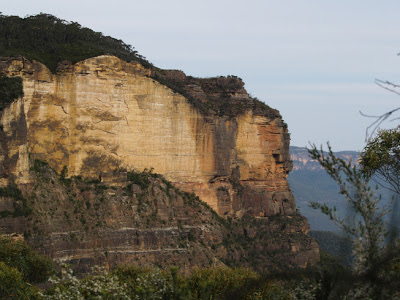
‘Cliffs crumbled due to coal mining, says new report’
(by Ben Cubby, Environment Editor, Sydney Morning Herald, April 27, 2010)
‘DOZENS of cliffs have crumbled or collapsed, Aboriginal rock art has been destroyed and metre-wide cracks opened in the earth as a result of coalmining in the Gardens of Stone wilderness area near Lithgow, an independent report has found.
The damage, inflicted over three decades by five coal mines and continuing today, is caused by subsidence from longwall mining, which now almost surrounds the Gardens of Stone National Park, part of the Greater Blue Mountains World Heritage Site. It is likely to be extended further if a new mine plan is approved by the NSW government.
The report, to be launched today by the former premier Bob Carr, documents wide-scale, unpublicised damage, including the destruction of some of the area’s unique sandstone pagodas and rock arches.
”In its monitoring reports to government, the coal industry regularly understates the damage caused,” said Keith Muir, the executive officer of the Colong Foundation for Wilderness, which produced the report. ”Mine operations do not work to minimise environmental damage and have been largely unresponsive to environmental concerns.”
The study based this conclusion on visual observation in the remote bushland and examination of the the environmental assessments used to justify the expansion of mining. In some cases, the assessments predicted that cliffs could crumble but no remedial action was taken.
The report looks at the six coalmines around the national park: the Angus Place, Springvale and Airly mines operated by Centennial Coal, Baal Bone and Clarence collieries operated by Coalex, and Invincible mine, operated by Coalpac. All the mining companies have met the requirements of their environmental assessment processes and have continued to monitor the impact of subsidence.
Reports produced by consultants employed by the companies showed more than 100 recorded cliff falls in the past three decades. Some led to changes in sites and techniques, but in the majority of cases the warnings were not heeded.
The damage was significantly worse above longwall mines, which cut out long, broad panels of coal, leaving the surface above to crack and subside. The Clarence and Airly mines use the bord and pillar technique, which involves leaving more coal in the ground to support the rock above, resulting in less surface damage.
Aboriginal rock art sites were also photographed with major fractures running through them and, in some cases, entire rock faces destroyed by the effects of subsidence.
”Crevasses, cliff falls and rock fractures are spoiling the sandstone beauty of the Gardens of Stone,” Mr Muir said.
The organisation is calling for a state-sanctioned conservation area that would provide a buffer zone around the park. It would cover part of the Baal Bone mine area, where a further expansion is planned, and the Newnes Plateau, where many swamps have been drained when the rock beneath them cracked open.
”The Department of Environment, Climate Change and Water has been considering proposals for additions to the Gardens of Stone National Park and an evaluation process is under way,” a spokeswoman said.
Read more: http://www.smh.com.au/environment/cliffs-crumbled-due-to-coalmining-says-new-report-20100426-tnbk.html#ixzz1MGS62mRx
.
.
Previously in 2007…

.
.
Further Reading:
.
[1] Previous article on this website: ‘Gardens of Stone at Risk from Coal Mining’, > https://www.habitatadvocate.com.au/?p=4021
[2] Blue Mountains Conservation Society, ^http://www.bluemountains.org.au/gos2.shtml
[3] Gardens of Stone National Park, ^http://www.worldheritage.org.au/resources/national-parks/gardens-of-stone-national-park/
[4] The Colong Foundation for Wilderness, ^ http://www.colongwilderness.org.au/Gardens_of_Stone/GoS2_home.htm
[5] Lithgow Environment Group, Inc. ^http://www.lithgowenvironment.org/mine_watch.html
[6] Lithgow Tourism, ^http://www.lithgow-tourism.com/gardenstone.htm
[7] Rivers SOS, ^http://riverssos.org.au/2011/04/27/help-us-protect-the-gardens-of-stone/
[8] National Parks Association of NSW, ^http://www.npansw.org.au/index.php?option=com_content&view=article&id=718:environment-groups-take-action-to-protect-gardens-of-stone&catid=172:2011&Itemid=564
[9] ‘Cliffs crumbled due to coalmining, says new report’, by Ben Cubby, Sydney Moring Herald, April 27, 2010, ^http://www.smh.com.au/environment/cliffs-crumbled-due-to-coalmining-says-new-report-20100426-tnbk.html

– end of article –
Environment groups take action to protect Gardens of Stone
The uniquely scenic and biodiverse Gardens of Stone is under imminent threat due to a consolidation proposal by Coalpac Pty Ltd. If approved, wildlife habitat and natural heritage will be lost forever, water systems will be stressed and there would be direct impacts for local residents. On Saturday 14th May, 2011 environment groups and their supporters will be taking action to help protect this iconic landscape from irredeemable destruction.
“Coalpac Pty Ltd seeks to extend open-cut and highwall mining into a large area of the publicly-owned Ben Bullen State Forest, NSW. The NSW National Parks and Wildlife Service has acknowledged its wish to add this forest to the conservation reserve system as a matter of priority” says Tara Cameron, Vice President of Blue Mountains Conservation Society.
“Many of the highwall scarps will abut strata directly below the ‘pagoda’ rock formations, their features and stability may be threatened by collapse. Environment groups are outraged at this proposal” says Tara Cameron.
“This forest is a publicly-owned area of conservation and recreational importance. The community expects state forests to be protected from destruction in perpetuity. If the NSW Government’s Strategic Regional Landuse Policy is to mean anything for sensitive, natural lands, then the Gardens of Stone must be protected from destructive mining operations, ” says Keith Muir, Director of Colong Foundation for Wilderness.
“This landscape is biodiversity hotspot, characterised by rich old-growth forests. Our iconic Lyrebirds use the sides of pagodas to nest and raise their young. Mining will completely remove their food habitats as well as the habitats of at least 32 threatened native animals” says Belinda Fairbrother, Campaigns Manager for The Wilderness Society NSW.
“Water management and impacts over such a large, exposed open-cut area are of great concern. The large open cut will also create significant dust and air quality issues which will impact directly on local residents” says Caroline Graham, Vice President of Rivers SoS.
“Environment groups are calling on the government to reject this mining proposal and act to protect the region within a State Conservation Area. We are coming together at this event to send a clear message that ‘We say No to open cut mining!’ in this iconic area of our state” says Kevin Evans, EO of National Parks Association of NSW.
“Across NSW, areas of high conservation value and great beauty are under threat from the rapid expansion of the coal and coal seam gas industries. During this time of transitional arrangements on the regulation of coal mining, the State government has an opportunity to deliver on its promise of better protection of water resources and the environment by rejecting further mining at the iconic Gardens of Stone,” says Pepe Clarke, CEO of the Nature Conservation Council of NSW.
Tags: Baal Bone, Barry O'Farrell, Ben Bullen State Forest, Blue Mountains World Heritage Area, Capertee Valley, Coal Mining, Coalpac Pty Ltd, Gardens of Stone, Genowlan Mountain, Hassans Walls, Lithgow Coal, Minister for Planning Brad Hazzard, Minister for the Environment and Heritage Robyn Parker, Newnes Plateau, Pantoneys Crown, Part 3A, Powerful Owl, Regent Honeyeater, Tiger Quoll, Wolgan Valley
Posted in Blue Mountains (AU), Threats from Mining | No Comments »
Add this post to Del.icio.us - Digg
Wednesday, April 13th, 2011
April 13th, 2011
The New South Wales Liberal Party has safely held the State electoral seat of Terrigal on the New South Wales Central Coast under its local party politician Chris Hartcher since 1988. In the March 2011 NSW election, Hartcher increased his margin by 15.9%, enough to run riot with a Liberal wish list.

Bulbararing Bay (Avoca Beach)
New South Wales, Australian east coast.
.
.
‘HMAS Adelaide’ scuttled off Avoca Beach today
[Source: No Ship Group, Wednesday 13th April 2011]
.
‘On the Liberal wish list has been dumping HMAS Adelaide in the clean waters off Avoca Beach (Bulbararing Bay) , which lies within the Terrigal electorate.
Today the NSW Liberal Party leader Barry O’Farrell, fresh in power, has fast tracked the scuttling of a scrap Navy warship off the coast of North Avoca Beach.

The Royal Australian Navy has conveniently saved money by sinking its scrap warship, HMAS Adelaide, off Avoca Beach. It is no different an environmental blight than all the sunk warships still polluting the Pacific after World War II. Obviously Navy culture harks to 20th Century habits and until local resident action group, No Ship Action Group, took legal action the Navy irresponsibly was happy to conveniently leave all the toxic polychlorinated biphenyls aboard for the scuttling.
[Read more about the health effects of ^polychlorinated biphenyls].
 HMAS Adelaide (Navy Frigate)
. HMAS Adelaide (Navy Frigate)
.
‘On March 27 the State Government arranged a party to dump this “clean” warship in our bay without proper community consultation or an Environmental Impact Statement. A community had to raise $70 000 to obtain the truth and they have now been ordered to remove additional toxic materials at a cost of over a million dollars. They have already admitted that much of this toxic material will remain on the vessel and our request for transparent scrutiny of the completed work has been denied.’
.

.
.
So the cost of the scuttling has been estimated to cost Australian taxpayers up to $8.5 million! What does the Navy care? Costs don’t seem to matter to the Navy, let alone environmental costs or community costs.
What does Chris Hartcher care about the impacts of dumping a scrap metal wreck to the values of local traditional owners, or to local marine life, to migrating humpback whales, to public health, to surf patterns,to sand drift or to beach erosion? None of them has enough votes, which is all that counts in party politics. Co-incidental that senior members of the Central Coast Artificial Reef Project, driving this scuttling project are ex-Navy divers.
 Humpback whale off Avoca Beach Humpback whale off Avoca Beach
.
The No Ship Action Group has highlighted comparable problems from the Adelaide’s sister ship, ex-HMAS Canberra, which was scuttled 2.3km off Ocean Grove, Victoria, in 2009.
Instead, the now promoted ‘Minister for the Central Coast’ Chris Hartcher said the wreck would generate millions of dollars in tourism and follow-on revenue for the coast’s economy.
“This will deliver significant recreational, tourism and economic benefits to the region, as well as educational and scientific research opportunities,” he said.
[Source: HMAS Adelaide sunk off Avoca Beach in NSW by Vince Morello 13th April 2011, AAP, ^http://news.smh.com.au/breaking-news-national/hmas-adelaide-sunk-off-avoca-beach-in-nsw-20110413-1dddv.html ]
Shame on the Navy, (as if it hasn’t enough shame already) for dumping its unwanted scrap on Australia’s coastline. Shame on MP Chris Hartcher and on Premier Barry O’Farrell. Dumping toxic ships in the ocean is an ‘archaic, reckless and wasteful act‘.
The so-called artificial reef will benefit selfish exploitist divers like the very vocal Terrigal Dive Centre.
.
.

‘HMAS Adelaide – The Only Thing Sinking on the Coast is Labor’s Resolve’
Tuesday, 09 June 2009
Shadow Minister for the Central Coast, Chris Hartcher, today called on Minister for the Central Coast, John Della Bosca and Member for Robertson, Belinda Neal, to get their act together and deliver the comparatively small amount of funding needed to bring the HMAS Adelaide to the Central Coast.
“This is a major project for the Central Coast. It has the potential to generate jobs and serious tourist dollars. I just can’t understand why the Labor Party have lost interest.
“This is one of the biggest issues facing local members, State and Federal but we’ve had nothing but eerie silence from Labor Members.
“Grant McBride mumbled some sorry excuse about bureaucracy but the reality is that he has the ear of the Premier. He’s right there in Nathan Rees’ party room. All he has to do is stick up his hand or pick up the phone.
“John Della Bosca is a Minister in the NSW Government – he helps hold the purse-strings. He could write the cheque today if he wanted to.
“And Belinda Neal has the ear of the Prime Minister – the man who stood by her through the Iguanagate scandal. Why won’t she just pick up the phone and ask for another favour?
“Coast residents shouldn’t be fooled – each and every Labor Member on the Central Coast is a mere phone call away from the money required to sink the Adelaide.
“But as usual, the Labor Party is full of excuses.
“It was a bureaucratic bungle, it was a mistake or they can’t find the funding.
“It’s all a bit ridiculous.
“Federal Labor and State Labor are under the same roof – why can’t they just get it together and cough up the cash?
“The State Labor Government has failed the Central Coast.
“The Federal Labor Government has failed the Central Coast.
“My message to each and every Labor MP on the Coast is a simple one; stand up against your own party’s incompetence and give us our artificial reef.
“The only thing sinking on the Central Coast at the moment is the Labor Members’ resolve.”
.
[Source: ^ http://www.chrishartcher.com/news_and_events/media_releases/hmas_adelaide_-_the_only_thing_sinking_on_the_coast_is_labors_resolve.html, accessed 13th April 2011.]

.
Lest We Forget the Local Protest
.
‘600 people join Avoca Beach protest against sinking ex-HMAS Adelaide’
[The Express Advocate, 8th March 2010, ^ http://express-advocate-gosford.whereilive.com.au/news/story/600-people-join-avoca-beach-protest-against-sinking-ex-hmas-adelaide/]

The golden sands of Avoca Beach turned to a sea of red Saturday morning when around 600 people turned up for a rally protesting the sinking of the ex-HMAS Adelaide.
Organisers had asked people to wear red as a sign of their opposition to the sinking of the ship 1.7km off Avoca Beach.
The concern that had been growing since residents discovered in January the ship would be scuttled off Avoca and not Terrigal culminated in Saturday’s rally where protesters danced and waved their hands to songs by Midnight Oil, the rock band formerly fronted by Peter Garrett, the environment minister who will sign off on the sea dumping, and cheered guest speakers who all spoke passionately about their environmental and lifestyle concerns.
Organised by the No Ship Action group, the rally was addressed by Dr Ian Charlton, a GP in the area and keen surfer, Quentin Riley, a long time Avoca Beach resident, Ben Smith an oceanographer and commercial pilot, Scott Forty, a doctor and dive enthusiast, Gary Whittaker, a builder, and Avoca Beach residents Kylie Hobin, Neil Robinson and Susan O’Connor.
“We all love Avoca Beach,’’ Mr Riley said.
“We are here to tell the truth about this situation. “We’re not just worried, we’re frightened, very frightened about the repercussions of the sinking of this ship.’’
Speakers spoke of the lack of consultation, the lack of an environmental impact statement (EIS), the lack of communication with the authorities organising the sinking, and the fear the ship will contain toxic materials including PCBs.
“If there has been an EIS, we would have been consulted 18 months ago,’’ Mr Riley said.
“We would have asked our questions then and we would have got answers. Around 4000 people never got the chance to comment or question the project.’’
Mr Smith, an Avoca Beach resident and commercial pilot, said he had grave concerns about the future of the beach and described the sinking as a ‘wanton act of vandalism’.
He said no other ship had been scuttled so close to shore.
“Stand up and be counted,’’ he said.
“This is our home and we don’t want that dam boat.’’
Mr Forty, a dive enthusiast, said most dive wrecks were located where they had met an unfortunate end, not placed in a pristine environment so close to shore.
“For a dive experience this is too good to be true, just a six minute boat ride from Terrigal and in only 30 metres of water,’’ he said.
“It will be like a Queensland theme park. “It should be scuttled further out and it would be a more interesting dive.
“Put it our further and it’s only a 20 minute ride, please rethink the site.’’
The two-hour rally finished up with the protesters lining up on the beach to spell out NO SHIP.
Lands Minister Tony Kelly said on Friday the scuttling was on schedule and would take place on March 27.
He said independent tests found no traces of PCBs on the vessel.
“I hope this now puts to bed unfounded claims being spread through the local community,’’ Mr Kelly said.
“All potential impacts have been considered including marine life, flora, fauna, water quality, swell conditions and sediment movement in the bay.
“The community can feel assured by these painstaking preparations and investigations.’’
.
.Common questions (from the HMAS Adelaide Reef website, before the scuttling):
.
1. Where is the Ex-HMAS ADELAIDE now?
The Ex-HMAS ADELAIDE is at the Sydney ports Corporation Berth No. 2 at Glebe Island on White Bay. It is undergoing final preparation for scuttling and its future as a dive site.
2. How is the site being designed for diving?
The Land & Property Management Authority (LPMA) has engaged the services of a team of designers who have been responsible for the design of every other military wreck around Australia. Assisting this team is a reference group which consists of representatives from local dive clubs, professional divers (such as the Navy, Police and Army divers), industry regulators such as Workcover and rescue personnel.
3. Who approves the environmental standard of preparation of the ship?
The ship will be prepared to the stringent environmental standards required by the Commonwealth Department of Sustainability, Environment, Water, Population and Communities (DSEWPC). They are responsible for approving the scuttling of the ship under the Environment Protection (Sea Dumping) Act 1981. You can also read our Environmental Fact Sheet about the Ex-HMAS Adelaide.
4. When and where will the Ex-HMAS ADELAIDE be sunk?
The scuttling of the Ex-HMAS ADELAIDE is scheduled to take place on Wednesday 13 April, so long as weather conditions are favourable. The vessel’s final resting place will be approximately 1.4km south of the Skillion at Terrigal and 1.8km off Avoca Beach in around 32m of water.
5. What will happen at this time?
On 11 April the Ex-HMAS ADELAIDE will be towed to the Central Coast. It will be escorted by police and other authorities and will have an exclusion zone in place. It will be anchored off Avoca Beach whilst final preparations are made such as cutting dive access holes above the water line. On the day of scuttling an exclusion zone of around 1000m will remain in place until after the Ex-HMAS ADELAIDE in scuttled and all safety checks have been completed.
6. What constitutes a successful scuttling?
The intention is for the Ex-HMAS Adelaide to be sunk in an upright position at the designated location and orientation, approximately ESE. Should the vessel not scuttle exactly as planned, this will not adversely affect its operation as a dive site and artificial reef. Some divers even suggest that it might be more interesting as a dive site if it is not perfectly upright.
For the scuttling process, an exclusion zone will be in place for the safety of spectators, and a spotter helicopter will check that there are no passing whales, dolphins etc.
7. Why are the weather conditions so important?
When the ship is towed out to be scuttled it will have no power or ability to move independently. It will also have many pre-cut panels in the hull above the water line which will become dive access holes once the panels are removed after arriving at the scuttling site. Calm weather conditions, little wind and low swell are required to safely take the ship out to sea and scuttle it.
In the event that weather conditions are not suitable to commence the tow from Sydney, towing will be postponed until Saturday 16 April, with the scuttling to take place on Monday 18 April, subject to favourable weather conditions.
Once the Ex-HMAS ADELAIDE is anchored off Avoca and planned scuttling is not possible due to unfavourable weather conditions, the scuttling will take place at the first available opportunity when weather conditions are suitable.
8. Where will the Ex-HMAS ADELAIDE be finally located?
The Ex-HMAS ADELAIDE will be located approximately 1.4km south of the Skillion at Terrigal and 1.8km off Avoca Beach in around 32m of water.
9. How many moorings will there be?
There will be six moorings placed around the ship. Two of these will be exclusively licensed to commercial operators, another two will be available for any commercial operator to book on a casual basis. The final two moorings will be available to recreational divers.
10. How will the dive site be managed?
A Crown reserve (the HMAS Adelaide Reserve) has been declared over the final resting place of the Ex-HMAS ADELAIDE. An agent will be engaged to market the opportunity to the dive and tourism industries, issue permits to dive the Ex-HMAS ADELAIDE and take bookings for moorings.
11. Will I have to pay to dive the Ex-HMAS ADELAIDE?
Yes. The ongoing management and maintenance of the dive site to ensure it remains a world class dive attraction will cost money. As such it is expected that a per dive fee will be collected to recover the cost of these activities. Pricing is yet to be determined.
12. How will I buy a ticket to dive?
A ticket to dive the Ex-HMAS ADELAIDE will be able to be purchased from the LPMA’s commercial agent. Before being issued with a permit all divers will be required to provide evidence that they have the necessary dive qualifications and agree to abide by a Code of Conduct whilst on the dive site.”
 Central Coast Artificial Reef Project Committee Central Coast Artificial Reef Project Committee
The CCARP committee is comprised of members of Brisbane Water Aqualung Club, Terrigal Underwater Group, Terrigal Diving School.
CCARP was originally created with the aim of lobbying the Commonwealth and NSW governments for acquisition of the decommissioned destroyer HMAS Brisbane. For a number of years the Australian Federal Government has had a policy of ceding to the states its warships as they become surplus to requirements and are decommissioned.
.
~ ~
.
…’Selfishness is not living as one wishes to live, it is asking others to live as one wishes to live’.
~ Oscar Wilde
..when
 Blessing Ceremony by local Indigenous people of Bulbararing Bay in 2008
^http://www.5landswalk.com.au/avoca-beach
.
~ WE NEVER ‘CEDED‘ ! Blessing Ceremony by local Indigenous people of Bulbararing Bay in 2008
^http://www.5landswalk.com.au/avoca-beach
.
~ WE NEVER ‘CEDED‘ !
 . .
‘Scuttling of warship will be a disaster’
[Source: Sydney Morning Herald, 20110412, ‘Scuttling of warship will be a disaster’, by Garry Trompf, Arcadia, Letters to the Editor, http://www.smh.com.au/national/letters/ , viewed 20110412.]
‘I am deeply concerned about the scuttling of HMAS Adelaide at Avoca (”Ombudsman sinks last bid to stop scuttling of frigate”, April 11, smh.com.au).
If the break-up of Adelaide’s sister ship, HMAS Canberra, is anything to go by, there will debris all over the beaches around Avoca within the next 18 months.
The navy’s destroyers which have previously been scuttled are all intact, but they are not constructed like frigates. The frigate HMAS Canberra has broken up after just 16 months. A New Zealand frigate lasted just six weeks before breaking into three and spreading debris all over nearby beaches.
The disintegration of HMAS Adelaide will also involve the dispersal of 23,000 square metres of lead paint and other dangerous contaminants in an area where migratory humpback whales (including calves) take shelter and where many families and children enjoy the beaches. It is a recipe for disaster.
Under the plan of management for the ex-HMAS Canberra, the dive site will be closed as a commercial site if the ship falls over or breaks up.
These issues are not mentioned in the review of environmental factors for the scuttling of HMAS Adelaide.
The NSW Ombudsman’s office has rightly asked for explanations on a range of issues. It has to be decided whether the state government has been complying with the orders of the Administrative Appeals Tribunal. The Premier should defer the sinking until the Ombudsman’s questions are answered.
I believe a reconsideration of the matter will reveal the utter lack of wisdom in allowing the vessel to be dumped in such environmentally sensitive waters.’
.
.
.
.
Naval history of ‘frigate dumping‘ on communities
.
The Royal Australian Navy has a history of dumping its friggin frigates on coastal communities. At 2 pm on Sunday, 4 October 2009, the Navy’s unwanted Guided Missile Frigate FFG02 HMAS Canberra was scuttled off the Victorian seaside town of Ocean Grove. Two years earlier, the Federal Government had committed $7 million of taxpayers money to prepare the ship for scuttling.
[Source: http://www.hmascanberra.com.au/sink-the-canberra.htm]
Just like the scuttling of ex-frigate HMAS Adelaide, the scuttling of ex-frigate HMAS Canberra was all so that local divers could have somewhere fun to play.
Seems a bunch of ex-Navy divers have come up with a novel way for the Navy to rid itself of old stock, while dive schools reap the promise of dive tourism revenue. But at whose expense?
Problem is that Victorian Artificial Reef Society and local divers may not get that chance to play, since the HMAS Canberra has been reported breaking up and is now deemed unsafe to dive on, and may never be. What is certain is that the Navy has dumped on Australia’s coastline. (Read article extract below: ‘EXCLUSIVE: HMAS Canberra breaking up‘).
Can Australian taxpayers expect to get their $7 million recompensed from the Nay from its botched HMAS Canberra scuttling? What chance is the $8.5 million from the HMAS Adelaide another botched scuttling? Couldn’t Australia’s Navy better spend the combined $15.5 million that it has scuttled, instead on meeting Australia’s important strategic Defence obligations?
In May 2007 the Navy was funded $52 million over four financial years for the continued surveillance of Australia’s northern approaches as part of Operation Resolute. $15.5 million represents about a third of that funding, which could have been better spent on more effective surveillance of Australia’s northern approaches.
[Sources: ^ http://www.navy.gov.au/Budget_boost_for_ADF, ^ http://www.navy.gov.au/Operation_Resolute]
.
Couldn’t Australia’s Navy be more responsible with its unwanted vessels by dismantling them and cost-recovering the parts for scrap/recycling?
.
.
.
EXCLUSIVE: HMAS Canberra breaking up
.
[Source: Ocean Grove Voice community newspaper, February 2011, ^ http://www.oceangrovevoice.com/2011/02/exclusive-hmas-canberra-breaking-up/]
.
‘PARKS Victoria has warned divers the ex-HMAS Canberra off the coast of Ocean Grove has begun to break up and could be dangerous, writes Carly Helweg.
.
The Victorian Government’s website reports the helicopter hanger on the port side of the ex-HMAS Canberra, scuttled in October 2009, “has separated from the main super structure.”
.
A statement issued on the Parks Victoria website said, “As a result the frames and plating on the port side are moving 30mm vertically and 150mm horizontally which may pose a hazard to divers in this area as the structure may move unexpectedly.”
“There are a large number of loose items in the lower deck and mid-ships areas of the vessel including lockers, cabinets, panelling and ducting.”
It warns, “It is strongly recommended that recreational divers stay away from these areas of the vessel to avoid the risk of personal injury.”
.
A NSW environmentalist group has used HMAS Canberra as an example in protesting the scuttling of sister ship, HMAS Adelaide, off Avoca Beach on the Central Coast.
According to an article in the Sydney Morning Herald on February 9, the No Ship Action Group at Avoca spokeswoman, Michelle Meares, said the Canberra has already tipped from an angle of 3 degrees to an angle of 22 degrees.
It is claimed if the Canberra leans over a certain angle it will fall, making it unusable as a dive site.
“When it gets to 27 or 30 degrees, it will likely tip over and not be able to be used as a diving wreck,” Ms Meares said to the Herald.
The Herald also reported, “according to Parks Victoria source, fiberglass insulation, foam insulation from wall and ceiling cavities, panelling and other debris is floating in the bay or has washed onto the beach.”
.
.
.
Further Reading:
.
[1] No Ship Action Group, ^ http://noship.com.au/
[2] HMAS Adelaide Artificial Reef website, ^ http://www.hmasadelaide.com/
[3] Search the Internet on the subject of ‘ artificial reefs impacts‘
[4] Now the Navy wants to sink another old ship at Jervis Bay…’ Sinking the HMAS Manoora in Jervis Bay‘, 201108 “Shoalhaven City Council has confirmed it’s in principle support on a proposal for the sinking of the HMAS Manoora as a dive site in Jervis Bay at last night’s extraordinary Council meeting.”
[Read Shoalhaven Council Report]
[Read http://sites.google.com/site/whathappenedatavoca/ex-hmas-manoora]
.
.– end of article –
Tags: Barry O'Farrell, Bulbararing Bay, CCARP, Central Coast Artifical Reef Project, Chris Hartcher, frigate dumping, HMAS Adelaide scuttling, HMAS Canberra, humpback whales, McMahon Services, No Ship at Avoca, noship.com.au, Operation Resolute, Parks Victoria, polychlorinated biphenyls, Royal Australian Navy, Sinking the HMAS Manoora in Jervis Bay, Terrigal Dive Centre, Terrigal Electorate, Victorian Artificial Reef Society
Posted in Threats from Dumping, Threats from Pollution | 3 Comments »
Add this post to Del.icio.us - Digg
|
|


")

")


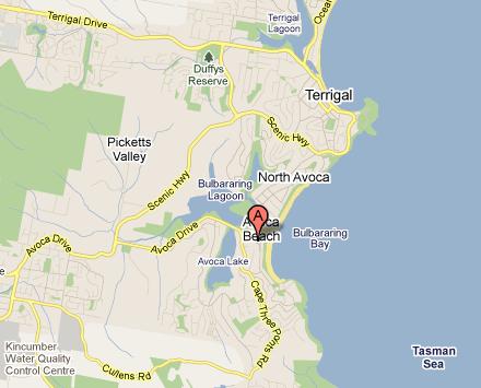
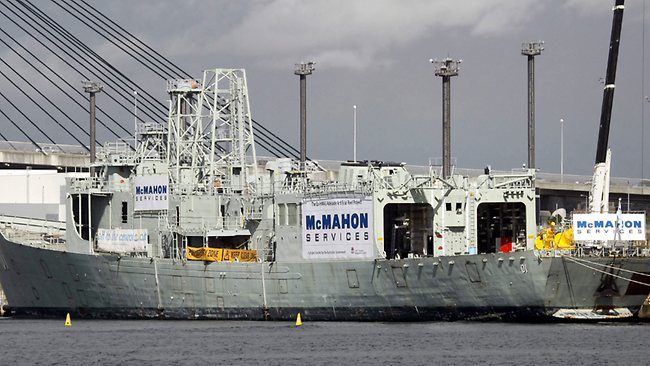