Temperate Highland Peat Swamps on Sandstone
Thursday, September 26th, 2013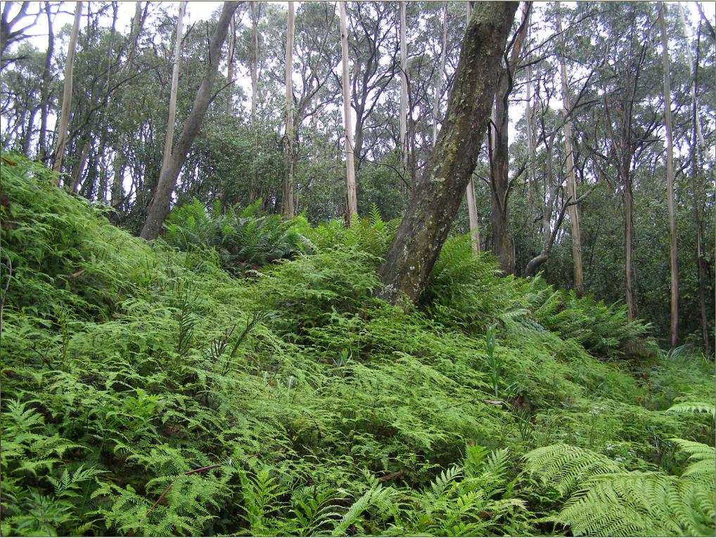 This is a Blue Mountains Swamp
It is a surviving remnant of Blue Mountains Swamps in the Sydney Basin Bioregion ecological community, which in 2005 were listed as Endangered by the Commonweath Threatened Species Scientific Committee.
[Photo by Editor 20120128, photo © under ^Creative Commons]
Click image to enlarge
This is a Blue Mountains Swamp
It is a surviving remnant of Blue Mountains Swamps in the Sydney Basin Bioregion ecological community, which in 2005 were listed as Endangered by the Commonweath Threatened Species Scientific Committee.
[Photo by Editor 20120128, photo © under ^Creative Commons]
Click image to enlarge
.
Blue Mountains Swamps?
.
Blue Mountains Swamps are globally restricted to the Central (and upper) Blue Mountains and to Newnes Plateau at altitudes between 600 m to 1200 m AMSL. They exist on peat soils above a sandstone substrate geomorphology. The soil tends to be water logged due to the presence of constant groundwater seeping over the impermeable claystone layers in the sandstone which impedes their drainage, however some swamps can be constantly flooded or else ephemeral, varying with seasonal rainfall patterns and more long term with El Niño/La Niña climatic phases.
Blue Mountains Swamps are typically situated at the headwaters of watercourses below ridges, but can also be hanging swamps on steep ridges, or valley bottom swamps. The structure and species composition of Blue Mountains Swamps varies with localised geology, topographic location, depth of the water table, extent and duration of water logging, drainage gradients, sedimentation and soil type.
Blue Mountains Swamp vegetation structure can range from being open or closed variants of sedgeland, rushland, heath, tussock grassland, tussock grassland, tall grassland, scrub and tall shrubland. The vegetation is typically under 3 metres in height, although taller shrubs may be present. Emergent tree species favouring wet root systems can occur on the swamp margins, and the vegetation here tends to be closed woodland in their undisturbed natural state.
Both the structure and species composition of swamp vegetation vary from site to site, and the individual species and structural types shown below do not all occur at every site. Within a single swamp area a complex mosaic of vegetation types (structure and species composition) may be present.
The structure of Temperate Highland Peat Swamps on Sandstone vegetation includes sedgeland, closed sedgeland, open-rushland, open-heath, closed-heath, tussock grassland, closed-tussock grassland, tall closed-grassland, open-scrub and tall shrubland. The vegetation is usually less than 3 m in height, although taller shrubs may be present. Emergent trees may occur on swamp margins, and the vegetation here tends to open woodland.
Typical vegetation is characterised by the presence of sedges, graminoids (grass-like plants) and forbs (herbaceous non-grass or grass-like plants) with or without shrubs. They are endemic to the upper Blue Mountains, comprising numerous small patches which aggregate to being about 3,000 heactares in total area. They occur naturally nowhere else on the planet.
Blue Mountains Swamps are scientifically included as a class within the nationally recognised Temperate Highland Peat Swamps on Sandstone ecological community. On 29th April 2005, Temperate Highland Peat Swamps on Sandstone was included in the list of nationally threatened ecological communities under section 181 of Australia’s Environment Protection and Biodiversity Conservation Act 1999. [Source: ^http://www.comlaw.gov.au/Details/F2005L01134]. This was mainly due to Threatened Species Scientific Committee recognising its limited distribution and vulnerability to ongoing threats.
It followed a ten year campaign by Blue Mountains environmentalists..
.
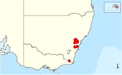 Global distribution map of Temperate Highland Peat Swamps on Sandstone ecological community.
[Source: Temperate Highland Peat Swamps on Sandstone, Biodiversity, Species Profile and Threats Database, Department of the Environment, Australian Government, ^http://www.environment.gov.au/cgi-bin/sprat/public/publicshowcommunity.pl?id=32#status]
Global distribution map of Temperate Highland Peat Swamps on Sandstone ecological community.
[Source: Temperate Highland Peat Swamps on Sandstone, Biodiversity, Species Profile and Threats Database, Department of the Environment, Australian Government, ^http://www.environment.gov.au/cgi-bin/sprat/public/publicshowcommunity.pl?id=32#status]
.
Twynam Swamp
.
Twynam Swamp is essentially an upland Blue Mountains Sedge Swamp dominated by coral fern (Gleichenia dicarpa).
It is situated on a hillside at the headwaters of Katoomba Creek in the heart of the distribution area for Temperate Highland Peat Swamps on Sandstone. The swamp here is predominantly a sedge swamp and is permanently water logged, probably due to the localised presence of natural groundwater springs.
This particular upland swamp area features a diverse ecological community including the following indicator swamp flora species:
.
-
Coral Fern (Gleichenia dicarpa),
-
King Fern (Todea barbara)
-
Tasman Flax-lily (Dianella tasmanica)
-
Soft Twig Rush (Baumea rubiginosa)
-
Fork-leaved sundew (Drosera binata)
-
Red-fruit Saw Sedge (Gahnia sieberiana)
-
Alpine Heath (Epacris paludosa)
-
Spreading Rope Rush (Empodisma minus)
-
Mat Rush (Lomandra longifolia)
-
Peat Moss (Sphagnum cristatum) in the ground layer
.
and a range of Hakea and Grevillea shrub species.
.
Characteristic of this upper Blue Mountains ridgeline landscape, above this swamp margin stands emerging Eucalyptus oreades, endemically rare in their own right.
Twynam Swamp is but one of the Blue Mountains Swamps localised fragile ecosystems coming under increased pressure mainly by deforestation for housing development and by frequent bushfires especailly from broadscale hazard reduction regimes. Both practices are not only facilitated by government, but sanctioned and enshrined in legislation, despite being scientifically recognised as key threatened processes.
.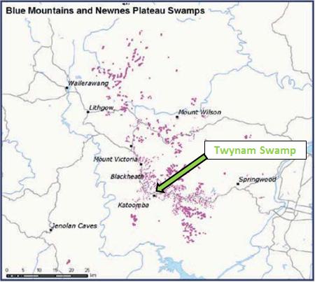 Larger scale distribution map of Blue Mountains and Newnes Plateau Swamps
[Source: ‘Nationally threatened species and ecological communities’, Department of the Environment, Australian Government,
^http://www.environment.gov.au/biodiversity/threatened/publications/pubs/temperate-highland-peat-swamps.pdf]
Larger scale distribution map of Blue Mountains and Newnes Plateau Swamps
[Source: ‘Nationally threatened species and ecological communities’, Department of the Environment, Australian Government,
^http://www.environment.gov.au/biodiversity/threatened/publications/pubs/temperate-highland-peat-swamps.pdf]
.
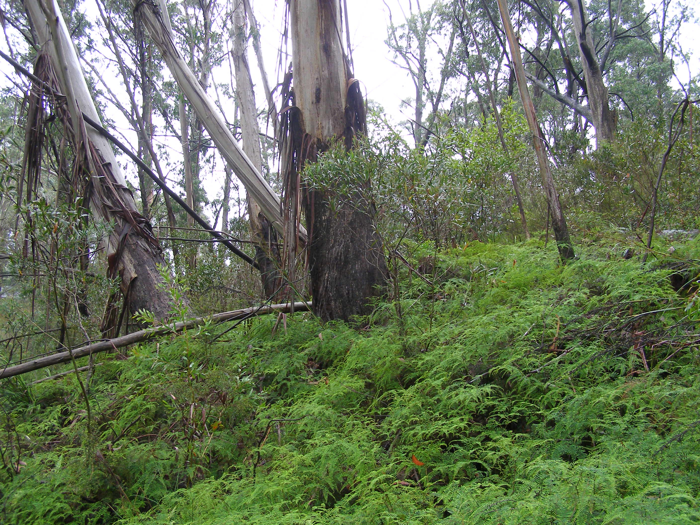 This Blue Mountains Swamp also contains a rare significant stand of Eucalyptus oreades (Blue Mountains Ash) around its periphery, which in itself holds rare ecological value.
[Photo by Editor 20120128, photo © under ^Creative Commons]
Click image to enlarge
This Blue Mountains Swamp also contains a rare significant stand of Eucalyptus oreades (Blue Mountains Ash) around its periphery, which in itself holds rare ecological value.
[Photo by Editor 20120128, photo © under ^Creative Commons]
Click image to enlarge
.
But try telling this to the local Blue Mountains Council. Council has just approved the bulldozing through and above this endangered and protected swamp for housing development.
Council’s zoning under its own Local Environment Plan of 1991 actually recognises this particular swamp as being environmentally protected. The swamp covers much of the Katoomba Creek headwaters site that has just been approved for housing development at the end of Twynam Street. It practically adjoins a restricted Sydney Water Catchment area on the ridgetop.
This site is a swamp. It has no connected water, power, gas or telephone. It has no stormwater connection. It is a swamp.
Not surprisingly, the developer’s Flora and Fauna Assessment has concluded that the bulldozing of the swamp will “unlikely.. (cause) any significant impact on any endangered ecological community, population or any threatened species and as such a Species Impact Statement.” [Source: Anderson Environmental Consultants, May 2012, for 121 Twynam Street, p. 13]
So Blue Mountains Council’s Senior Environmental Health and Building Surveyor, Daniel Roberts, approved construction two weeks ago (12th September 2013) for a two storey dwelling and driveway to carve through this Blue Mountains Swamp. The consent conditions for this development application (X/673/2012) read as if the site was just an urban block of land in downtown Sydney; nothing special.
Rules for some?
Still council’s wholesome vision advocates “respecting our heritage and safeguarding our fragile environment” – a clear disconnect between propaganda and practice.
.
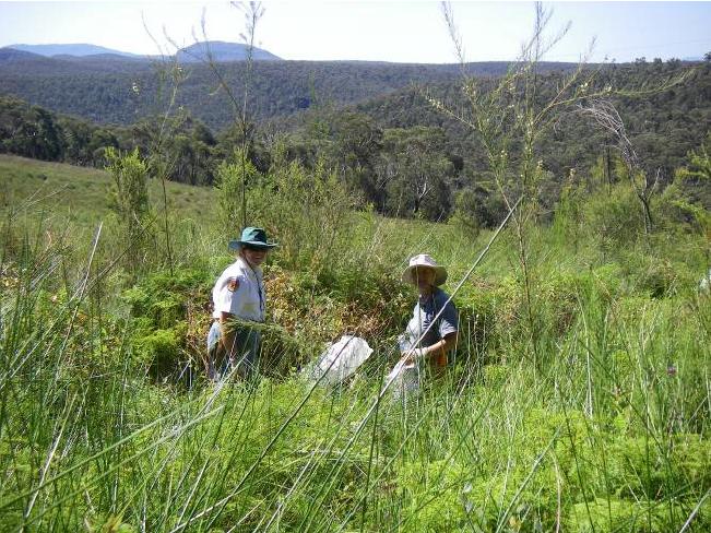 Blue Mountains Swampcare at Kittyhawke Swamp, Wentworth Falls.
Similar swamp characteristics, just more convenient location for Council and Parks Service to jointly show they care.
[Source: Blue Mountains Council’s Upland Swamp Rehabilitation Programme (2007) enticing community volunteers.]
Blue Mountains Swampcare at Kittyhawke Swamp, Wentworth Falls.
Similar swamp characteristics, just more convenient location for Council and Parks Service to jointly show they care.
[Source: Blue Mountains Council’s Upland Swamp Rehabilitation Programme (2007) enticing community volunteers.]
.
Ed: To Blue Mountains Council development staff, ‘Temperate Highland Peat Swamps on Sandstone’ national legislation is a discretionary matter depending upon where the swamp happens to be situated.
.
Blue Mountains Council is content to be hypocritical about its stance on protecting Blue Mountains Swamps under its Swampcare Programme, while at the same time its development planning staff authorise destruction of these swamps. It is in flagrant breach of national legislation.
Fortunately, there remain many in the local Blue Mountains community who place high value and have due respect for Blue Mountains Swamps and their need for consistent protection under the national legislation, irrespective of where the swamps happen to be situated. Next door resident, Francis Scarano, has repeatedly objected to the Blue Mountains Council about this development’s certain destructive impact upon the swamp:
.
“The swamp out the front will die along with the E. Oreades as they are not able to cope with excavation for the drive way across roots and concrete next to them and the swamp cannot cope with cut ground water supplies.
What happens when you build above a swamp? You kill a swamp even if you do not build on it. Development above is more than enough to do the job. Winding roads around Eucalyptus oreades grove and building turning bays is enough to make the trees in groves to fall down. Even though the developer is not clearing the oreades grove or swamp his actions will kill them all the same but more slowly.
The swamp particularily depends on the hydrology ie underground springs being undisturbed. They do not understand that building above a swamp will kill it anyway.”
.
Her concerns have fallen on deaf, ignorant ears at Blue Mountains Council.
But council ignorance has not stopped local residents making a stand to save this precious remnant swamp.
.
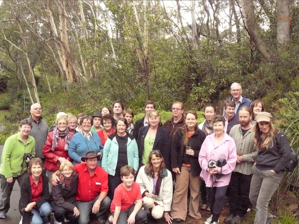 Friends of Twynam Swamp
A collective of friends of Francis Scarano who stand in solidarity with Frances Scarano
to save Twynam Swamp (behind) from the developer’s bulldozer.
[© Photo by Francis Scarano, 20130327]
Friends of Twynam Swamp
A collective of friends of Francis Scarano who stand in solidarity with Frances Scarano
to save Twynam Swamp (behind) from the developer’s bulldozer.
[© Photo by Francis Scarano, 20130327]

")
")
")
")

")


")


 Blue Mountains Swamp")

")
")


