Posts Tagged ‘Leionema lachnaeoides’

Elphinstone Plateau deserves World Heritage

Wednesday, July 26th, 2017

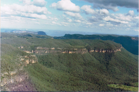
Elphinstone Plateau from the north

© c.1991 Wyn Jones (biologist, NPWS)

Elphinstone Plateau is magnificently wild, forming an outstanding undeveloped peninsula-plateau jutting out into the Megalong.  It has long been a favourite wilderness destination for bushwalkers and rock climbers alike.

This predominantly natural and undisturbed plateau is mistakenly also referred to as ‘radiata plateau‘ due to a small invasive private pine plantation from the 1970s covering less that 5% of the plateau along an access track .  The plantation failed and the owner went broke.

Yet little known Elphinstone Plateau remains special home to rare and threatened regionally native species, culturally significant to local Aboriginal peoples and a magnet for the local outdoor community.

Sitting on the southern escarpment, Elphinstone Plateau, just west of Katoomba, towers high above rolling valleys has outstanding topography.  It remains the last remaining undeveloped peninsula-plateau in the upper Blue Mountains.   The Plateau has significant biodiversity, including vegetation communities such Blue Mountain Swamps, Eucalyptus Oreades Open Forest and Blue Mountains Heath.   It is also home to many endangered species including the Flame Robin, Glossy Black Cockatoo, Gang-Gang Cockatoo and the Varied Sittella as well as the Tiger Quoll, frequently sighted by locals.  Threatened plants include one of only ten places on the planet where the Dwarf (Blue) Mountain Pine (Pherosphaera fitzgeraldii) is endemic on the planet to the immediate upper Central Blue Mountains with its distribution fragmented to a few south-facing hanging swamp cliff faces on the Blue Mountains western escarpment at Elphinstone above Nellies Glen and nearby around Wentworth Falls above the Jamison Valley.

The IUCN reports that this taxon is endangered. It faces a very high risk of extinction in the wild in the near future due to a small population size and severe population fragmentation, with no sub-population estimated to contain more than 250 mature individuals.

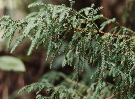
The Dwarf Mountain Pine endemic on the planet to wet rocks within the spray of waterfalls of Elphinstone and Wentworth Falls

(Harden 1990, Hill 1998)

Steven, one of our local conservationists says that this wild plateau has significant biodiversity – Blue Mountain Swamps, rare Eucalyptus oreades Open Forest and many endangered species including the Flame Robin, Glossy Black Cockatoo, Gang-Gang Cockatoo, and the almost unknown Tiger Quoll.  


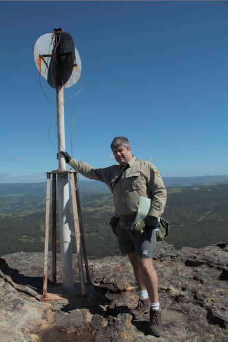
One of our local conservationists at Megalong Head on Elphinstone Plateau

Steven says that the plateau and its immediate surrounds provide are the only locality on the planet to naturally support the critically endangered Dwarf Mountain Pine and the little-known yellow flowering shrub Elphinstone Boronia (Leionema lachnaeoides).  Both are threatened with extinction and their survival depends on the area remaining undisturbed.

 
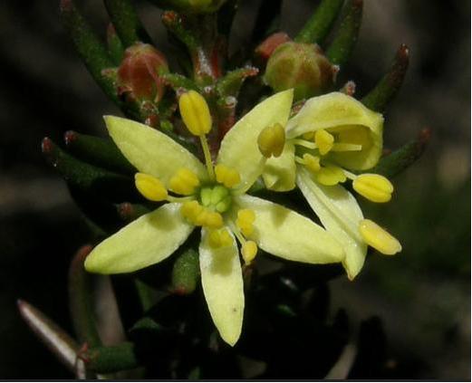
Threatened species Elphinstone Boronia  (Leionema lachnaeoides)

Endemic to Elphinstone Plateau (that means it grows natively nowhere else on the planet)

© Waratah Software


Survival depends on the area remaining undisturbed. 

Steven says local resident Glenn Humphreys has been involved with trying to protect and save Mount Elphinstone from housing development on and off for more than 25 years, successfully halting all sorts of elaborate development proposals.  

But now this wild and unique haven is at risk.   An integrated part of the Blue Mountains western escarpment has come under threat of land use development again – Mount Elphinstone (also mistakenly called Radiata Plateau) situated a few kilometres west of Katoomba.   Apart from a small area of Crown Land the majority of the Plateau is privately owned by a group that have repeatedly lodged development applications since the 1990s.  


Elphinstone Namesake


Mount Elphinstone, being the highest rise on the plateau is believed named after Major General Sir Howard Craufurd Elphinstone, VC, KCB, CMG (1829 – 1890) who was a British Army officer and a recipient of the Victoria Cross.

Born in Livonia (now Estonia), Elphinstone joined the British Corps of Royal Engineers as a gentleman cadet at the Royal Military Academy, Woolwich and was commissioned as a second lieutenant in December 1847.  With the outbreak of the Crimean War, Elphinstone was posted to the Crimea.  

On 18 June 1855, he was 25 years old, and a lieutenant in the Royal Engineers, during the Siege of Sebastopol when the following deed took place for which he was awarded the Victoria Cross.VC.

His citation read:

“For fearless conduct, in having, on the night after the unsuccessful attack on the Redan, volunteered to command a party of volunteers, who proceeded to search for and bring back the scaling ladders left behind after the repulse; and while successfully performing this task, of rescuing trophies from the Russians, Captain Elphinstone conducted a persevering search, close to the enemy, for wounded men, twenty of whom he rescued and brought back to the Trenches.”

With the end of the war he was decorated by both Napoleon III, Emperor of France being appointed as a Knight of the Legion of Honour.


Private Development Threats to the Plateau


A proposed private development threatens its future.  Currently, two of three development applications recently lodged have been refused, leaving one approved for two dwellings.  They pose an inappropriate development wedge to future residential exploitation of this still wild plateau.

Now is the time to prevent any building and move the Plateau in public ownership for protection.   This could be the public’s last chance to secure the future of this stunning area and have Elphinstone Plateau become part of the National Park estate.

Blue Mountains residents,  the local outdoor community, and the Blue Mountains Conservation Society are all firmly committed to seeking protection for the Plateau.  We were delighted with all the community support our campaign received at Winter Magic – with lots of cheers from the crowd during the parade and most importantly all the letters sent off to the Minister for the Environment.

We are seeking to have Elphinstone Plateau purchased by the New South Wales or Australian Commonwealth governments and be incorporated into the Blue Mountains World Heritage Area.

But the battle is not yet won.  The local Blue Mountains Conservation Society is championing an environmental campaign to oppose the land use development and to have the plateau incorporated into the adjacent Blue Mountains World Heritage Area.

The Society is inviting locals and those passionate about protecting this special place, to join in a rally on Sunday 30th July at 1.30pm at Cahill’s Lookout, Cliff Drive, Katoomba.


Further Reading:

.

[1]  Leave Radiata Plateau Wild Campaign,  ^http://www.bluemountains.org.au/leaveradiataplateauwild/

.

[2] Elphinstone (Radiata) Plateau – Bushwalk: Bottleneck Pass and The Devils Hole (29 June 2016) by Dave Noble (NPWS), ^http://www.david-noble.net/blog/?p=11300

.

[3]  Dwarf Mountain Pine (Pherosphaera fitzgeraldi), The Gymnosperm Database, ^http://www.conifers.org/po/Pherosphaera_fitzgeraldi.php

.

[4]  Major General Sir Howard Craufurd Elphinstone, ^https://en.wikipedia.org/wiki/Howard_Craufurd_Elphinstone

.

Bushland housing driving BM deforestation

Saturday, May 28th, 2011

Valuable fringe bushland of the Central Blue Mountains (BM) is steadily disappearing as a consequence of Blue Mountains (city) Council-approved housing development integrated with the associated hazard reduction burning that it invites.

Blue Mountains Council has become culturally conditioned to automatically squirm and acquiesce when any threat of a State Environmental Court appeal process that may be instigated to dare challenge Blue Mountains Council, despite a fair and rigorous environmental assessment and ruling.   Local political pressure is such that now Blue Mountains Council staff are encouraged to give up and bend over, as if so urbane as to be beholden to developer intimidation.  Yet for years such has become Blue Mountains Council’s urbane squeamish mindset, as if the staff and management came from overdeveloped Western Sydney (which most of them they have).

There are morally corrupt politics controlling land use development in the Blue Mountains ~ many are receiving a cut of perceived cheap, yet increasingly scarce, bushland habitat.

Thick natural bushland habitat just west of Katoomba
Central Blue Mountains Region.
New South Wales, eastern Australia.

.

.

Case in point:

.

Not so long ago, Blue Mountains Council approved this cypress pine cottage be built in/abutting thick timbered bushland on a west facing slope downwind of the prevaling westerly winds.

Bushfire risk mapping rated the site as ‘extreme’ bushfire risk, yet the cypress pine cottage got built.  The builder/developer has long since profited and so moved on, leaving behind a bushfire vulnerable cottage on a site that should never have been built on in the first place.

But try telling a pro-development council that a property owner can’t develop his/her land!

The cypress pine cottage, 2008
.

The site was purchased in/abutting dense wooded bushland, which was slashed and bulldozed.   Down from the house, around a dozen mature native trees were chainsawed to provide for escarpment views to the west.

One of the chainsawed native trees
.

The property has since been sold.   Yet, the issue of a cypress clad cottage being approved in extreme fire risk bushland was raised with Blue Mountains Council’s senior development officer, Lee Morgan, on 25-Feb-2009 (Council ref.  Customer Service Request #106889).  But there was no response.

The cottage was sold in 2008…with views
…less the dozen chainsawed Eucalypts to make way for the views.

.

It is typical of Blue Mountains Council’s planning approvals that they encourage development encroachment on the fringe bushland which separates the Blue Mountains National Park from the townships of the Central Blue Mountains.

A nearby cottage of remarkably similar cypress pine cladding
has surrounding trees chainsawed and the vegetation slashed to bare earth.

.

.

Then comes the ‘hazard’ reduction

.

Housing development encroachment is being wedged deeper into fringe bushland, closer to the Blue Mountains National Park, many seeking the profit that escarpment views bring.  The sites are indefensible against bushfire.  Many are zoned extreme bushfire risk, yet these bush houses received Council building approval.

The Rural Fire Service (RFS) calls for hazard reduction because, with just its truck resources,  it would not have access to defend these houses in the event of a serious bushfire.   Co-incidentally, the property owners (developers) now cry for RFS hazard reduction to protect their ‘assets’ from the risk of bushfire.   Co-incidentally, many property owners (developers) in the vicinity who have these new bush houses do the same.

Of course, to the fire-lighting cult, this is music to their ears and so the Rural Fire Service in cohorts with Blue Mountains Council rustled up a hazard reduction certificate.  In September 2008, Blue Mountains Council’s Bushfire Technical Officer, Peter Belshaw, issued a Hazard Reduction Certificate for over 11 hectares of bushland and escarpment heath across Bonnie Doon Reserve to be burnt under a ‘hazard’ reduction programme.   Click on image below for details.

Click image to open PDF document

.

Earlier that year in mid February (2008), some seven months prior, slashing of heathland and a watercourse had been carried out by a Rural Fire Service contractor in preparation for the hazard reduction burning ~ the fire-lighters just couldn’t wait.

Blue Mountains escarpment is slashed by the RFS, a kilometre west of the cottage site.

.

.
 
The RFS contractor slashed a trail for over 700m through heathland and through a riparian zone,
even before the Hazard Reduction Certificate was issued.
.


Then comes the intense HR burning:

.


Three years hence, mid afternoon on Friday 11th February 2011, smoke can be smelt and seen rising to the west on the horizon near Bonnie Doon Reserve. A call to emergency ‘000’ confirms that it is not a bushfire, but that official hazard reduction operations are underway.  It is still well within the bushfire risk season.

.

Bonnie Doon Reserve is a natural wild area of about 22 hectares that includes a mix of bushland, heathland and upland swamp situated on the Blue Mountains escarpment at the western fringe of the township of Katoomba.  It lies above Bonnie Doon Falls.  The area is zoned ‘community land’ and ‘environmental protection’ and comes under the control and custodianship of the Blue Mountains Council.  Bonnie Doon Reserve has a history of volunteer bushcare to conserve the still wild Blue Mountains escarpment habitat.  The reserve is immediately upstream of the endangered Dwarf Mountain Pine (Microstrobos fitzgeraldii) and Leionema lachnaeoides (yellow flowering shrub) found almost nowhere else on the planet.  The habitat conservation of both species, particularly the exclusion of fire are considered critical to their survival as a species.

The ‘hazard’ reduction (HR) burning commences

.

From a distance of about two kilometres, I can see the smoke billowing strongly and its lasts for over two hours.   The direction of the smoke places it around Bonnie Doon Reserve.   The strength and density of the smoke indicates that it is more than light burning of ground cover.  It is an intense but localised fire.

.

The aftermath of the burning:

.

We have our suspicions, but with other commitments we can’t get around there for some time to investigate the location affected to determine the scale and severity of the burning.  In fact it isn’t until nearly three months later on Sunday 1st May 2011, that we inspect the burnt site.  The fire was localised.

The aftermath
Three months on, evidence of more than just ground-cover has been burnt.
Deliberate intense burning has been allowed to penetrate deep into mature Eucalypts

.

.

The fire was so intense that the flames reached into the tree canopy.
It must have been a blaze and half for RFS fire-lighters.

.

.

RFS telltale
.

The fire was indeed localised.  It is very clear, still three months on, that this ‘hazard’ reduction burn had specifically targeted the native bushland surrounding the cypress cottage – an area of perhaps two hectares.

Consequence:

So not only has the developer of the cottage site completely destroyed the bushland on the site, but he has succeeded in having an additional two hectares burnt in the process all associated with the one cottage.  Council’s initial approval of the cottage construction has directly led to the destruction of two hectares of what began as intact native bushland.   The developer has profited from the bush, but in the process the ecological cost has been ignored ~ it is a perpetuation of a 19th and 20th Century single bottom line exploitation of the natural environment.  It is happening across the Blue Mountains and being encouraged by Blue Mountains Council rules, practices and attitudes.

.


The cottage relative to the HR burn (aftermath)

.


The cottage now with great views, plus an extra 2 hectares of cleared bush done cheap
Blue Mountains (city) Council making bushland-fringe development cheap
 

.

The ‘hazard’ reduction certificate process has become an insidious part of the development process across the Blue Mountains.  The catalyst that is Council’s lax bushland protection zoning, is facilitating fringe deforestation.    The combination of Council’s housing approvals on bush blocks with its ‘hazard’ reduction approvals have become a self-perpetuating twin mechanism for incremental encroachment into Blue Mountains fringe bushland, and it shows no sign of stopping.


Bushland habitat at Bonnie Doon at risk of further burning

.

Hazard reduction has become a cosy win-win-win-win outcome for all collaborators:  (1) the builder/developer who profits, (2) the real-estate agent who get the sales commission (first when the bush block is sold, then again when the house is sold with views), (3) Council which earns developer charges in the short term and an expanded rate revenue base over the long-term, and (4) the RFS fire lighters who have become more adept and occupied lighting bushfires than putting them out.

Fire-lighters look on during the Hazard Reduction Burn, Bonnie Doon Reserve

.

More bushland for sale
~ a ‘lose-lose’ outcome for native habitat and the remnant disappearing wildlife is supports.

.

An harbinger of more burning for Bonnie Doon:

.

Of the eleven odd hectares of the 22 ha Bonnie Doon Reserve targeted by the RFS for slashing and burning on the hazard reduction certificate, nine hectares of bushland and escarpment heathland still stands to be burnt, which could happen anytime.

Bonnie Doon Reserve
on the western fringe of Katoomba township
(click photo to enlarge)
(Photo by us, so free in public domain)


.

– end of article –


.

 
Blue Mountains escarpment is slashed a kilometre west of the house site

, in preparation for over 11 hectares of buring Bonnie Doon Reserve

error: Content is copyright protected !!