From our personal experience, we would NOT describe The Carrington Hotel as being a good neighbour in Katoomba where we live.
On Saturday late morning 26th October 2024, from where we live in The Gully Catchment of Katoomba, we were dozing at home as not feeling particularly well.
Suddenly, we then get this pounding deep bass sound reverberating from somewhere not far away. It was so loud that it became impossible to sleep through. Where was it coming from?
Ours is a quiet residential neighbourhood set in the oldest heritage precinct of the Blue Mountains. Our street dates to the 1870s, even before The Carrington Hotel of 1883 up on the hill.
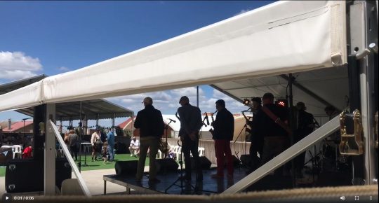
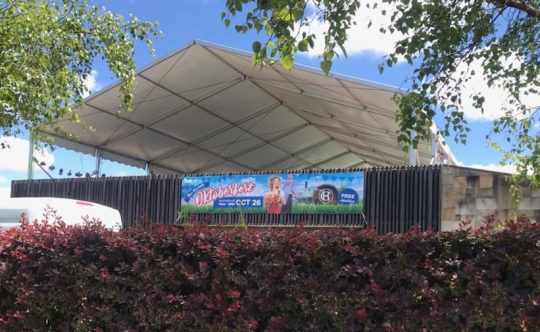
So we get up and dress to investigate the noisy racket. We shortly find the source just three short streets away. We reproduce two samples below, but the volume is ten times louder that what the AMR software on our iPhone has captured. Most of the band playing sounds out of tune.
It’s that bloody Carrington Hotel again, thumping its amplified festival music from what is supposed to be its large car park rooftop on nearby Parke Street on the top of the hill in our township of Katoomba.
We had previously raised our concerns about a similar car park festival episode directly with one of The Carrington’s joint owners on a previous occasion back in February 2024, when some other concert started up on top of the same car park playing loud amplified music (multiple large stage speakers pointing in direction of our home) so audible as to be heard down into The Gully, half a kilometre away.
On this occasion, 26th October, it was some blood brass band amplified up at full volume, again! WTF!
Yet there are residential homes just across Parke Street, just metres away from the stage where the band is playing, like ours about 300 metres away from the now fabricated temporary stage.
This is what we heard and saw on the car park second storey upon our investigation after having just woken up…
This is just not fair! A festival with loud amplified music set up juxtaposed to residential homes? It’s so selfish and arrogant and it’s not right. It’s hardly respecting the rights of immediate locals like us to our quiet enjoyment. It’s a noise impost.
And it’s also so unnecessary that this particularly large accommodation hotel with options of utilising its multiple internal entertainment spaces and on such an extensive site, should resort to re-purposing its purpose built guest car park into a festival venue and so cause annoyance to locals immediately across the street (Parke Street) and on to adjoining quiet back streets like ours within earshot.
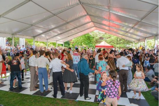
We say this because The Carrington Hotel has ready onsite access also to a similarly sized level grassed area at the front of the hotel site just off retail Katoomba Street. The Carrington has long used this level open lawned space for various festivals and events. It’s a perfect location in the retail heart of Katoomba!
The Lady Luck Festival has been run for the past 14 years using both this marquee for dancing plus the inside of the Carrington’s sizeable ballroom.
So, then why move the Carrington’s marquee from here in town to the rear car park opposite residences?
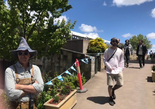
Today, unable to sleep and feeling a bit crook, we approached the entrance to the car park festival and briefly expressed our concerns to some bloke in a pixie hat and joker costume about the loud amplified noise and that we lived just a few streets away. The bloke happened to be one of The Carrington’s joint owners in disguise. He promptly got agitated with one’s comments and then immediately ordered me to leave his property, as in “bugger off”!
The Carrington’s nasty pixie (left). Note the body language.
As a Katoomba resident where we live since 2001, we provide some instructional background.
A few years back, Blue Mountains Council granted The Carrington Hotel development approval to double the size of its car park off Parke Street on its very large site. The approval was to build a second storey car park above the existing car park so as to double off-street parking capacity for its in-house guests. This followed substantial renovations of many rooms which so increased the hotel’s accommodation capacity.
We have no problem about The Carrington Hotel’s enlarged car park being used as a car park for its staying guests. The investment into restoring, upgrading and diversifying the Carrington continues to wonderfully appreciated for Katoomba. As long locals we know of no other tourism establishment that has done so this this extent. This is a credit to its joint owners.
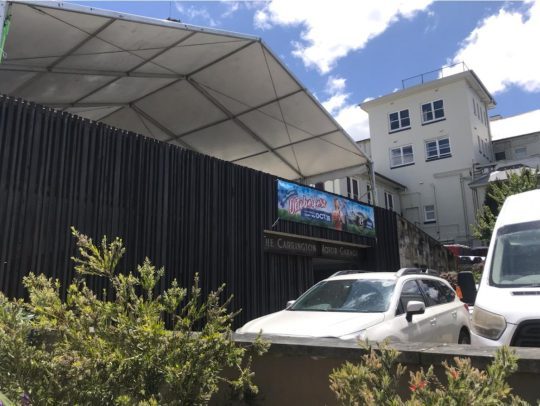
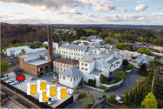
The car park concrete structure is about the size of a narrow-elongated basketball court and further dominates the hotel’s 4 storey high-rise landscape on top of the hill in uptown Katoomba.
This festival is the Carrington’s own Oktoberfest on 26th October since 2023. We were away at the time that year.
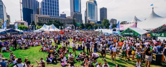
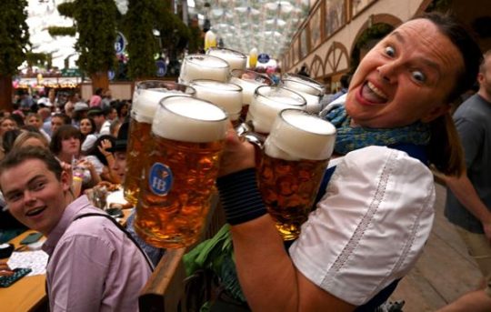
But why a decision for a remote miniature Oktoberfest festival in Katoomba outside Sydney, when there has long been a huge one in Sydney’s Botanic Gardens annually every October attracting thousands? It’s held on the very same day on the 26th!
So why the hell would tourists in Sydney not conveniently head close by to the real big deal in Sydney, to instead choose a 4-hour return train ride to The Carrington car park in Katoomba for a half-pint to bad music? No chance!
Sydney’s ‘Oktoberfest in the Gardens’ 26th October
A big double storey concrete car park is one thing, but then we discover they’re starting to use it for ticketed music festivals and even lease it out to independent festival organisers. So they’re profiting from festivals despite never having had such Council approval to do so. We would have objected had the development application plans included converting the car park into a venue for external festival hire.
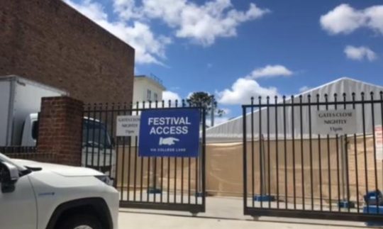
This is the car park in question showing its driveway entrance off Parke Street. The brass band is playing behind the car park gates on a stage behind the calico screen inside the temporary marquee.
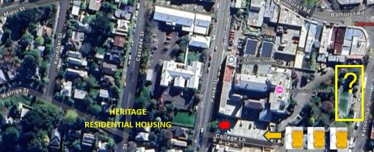
The following aerial view of this precinct in Katoomba (Google Maps) shows the relevant juxtaposition of The Carrington hotel with its car park used as a band stage (shown in red), plus the remaining section of the car park for audience seating and outdoors drinking of German beers in large jugs.
It also shows the proximity of the residential housing and also the similar sized garden lawn (yellow rectangle) situated within the Carrington grounds off Katoomba Street.
The Carrington Hotel and its juxtaposition
Same problem, different camera angle. Who approved a car park for festival hire?
So why doesn’t the Carrington simply return to using the Council-approved outdoor entertainment space it had purposely re-developed on its flat lawned area right in the retail heart of Katoomba, rather than pissing off local residents to the west of the hotel.
Some big business people presume they can do what they want and bugger everyone else? Perhaps the owners would benefit more by investing quality time researching negotiation pathways with local Council to mitigate the costs of returning to utilising the grassed area for events as before and the Carrington’s similarly sized large ballroom. But diversifying into illegally using the hotel’s guest car park to hock for event leasing to external festival organisers for a pittance return?
Indeed the event is promoted as “free admission” as per the banner outside (see below). So what its the point of this event? The musicians would not be performing for free. Only the beer it seems, is for sale. So the whole thing appears to be a loss making exercise. Is this for the indulgence of the pixie who just likes getting dress down and drinking beer? Or is he just wanting to piss off the neighbours?
The event banner reads “Free Admission”
Of course, while the car park has been leased out, many of The Carrington’s in-house guests will be denied the brochured off-street parking, so be relegated to use Council’s on street paid parking, costing over $100 per day. We suggest this pet project to annoy locals is a false economy. So as Katoomba long-time locals, we wont be frequenting The Carrington any time soon. The actions of The Carrington are so unneighbourly.
The big concern we have is that this illegal use of the car park repurposed for festivals, risks setting a precedent for drunken crowds and on a more frequent basis. The toilets are not convenient to the car park. The only toilets are well inside the hotel itself, passed reception, passed the bar if you now where to find them. So what is preventing drunken party goers after downing a full German beer jug or three, desperate for a leak, taking advance of the adjacent brick walls of the adjoining Blue Mountains Cultural Centre and the front fences of local homes to urinate into the wee hours. There are no toilets in the car park. Is the car park a licensed venue to serve alcohol? We’ve not heard.
What is to come if this is allowed to snowball into a more regular Carrington Hotel Booze Fest, fuelled by incoming bus loads of yobbos on bucks nights.
Surely, no Katoomba local here wants this problem. The festival lease brain-snap for a re-purposing of the car park needs to stopped in it tracks before it morphs out of control!
As if Katoomba doesn’t already have enough booze outlets!
Where is local Blue Mountains Council in all this?
Comment:
Judy Harding:
“I text the Carrington saying I was considering staying there but have been told it’s too noisy because of the bands playing in the car park so I have decided to stay in Leura.”
[2] ‘Oktoberfest in the Gardens‘, Botanic Gardens of Sydney, ^https://www.botanicgardens.org.au/whats-on/oktoberfest-gardens, Australia’s biggest and best Oktoberfest celebration returns to Sydney in 2024, Abstract: “Inspired by a love of the traditional Bavarian festival and great beer. Oktoberfest in the Gardens Sydney features two massive beer halls, authentic German food stalls, roving performers, sideshow alley, silent disco and an eclectic mix of entertainment and competitions across multiple stages throughout the afternoon and evening. Taste your way across Europe with a large selection of imported German beer, cider, wine and a range of other beverages.”
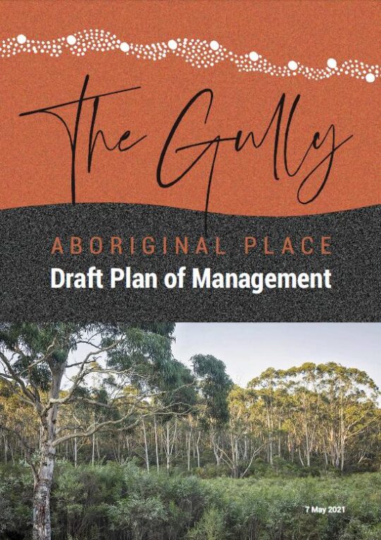
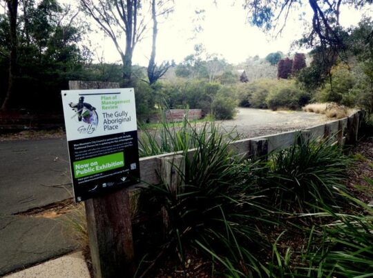
This was the May 2022 draft, however on this website we include Blue Mountains {city} Council’s complete final version dated 4th October 2022, which numbers 145 pages. Click our internal website link below to download a PDF copy of this entire Gully Plan of Management 2021 (Final), ^https://www.habitatadvocate.com.au/wp-content/uploads/2021/11/The-Gully-POM-4-Oct-2021.pdf
Local residents in and around The Gully water catchment area situated on the western side of the rural township of Katoomba may be astounded by the following truths we at The Habitat Advocate have gleamed of late about Blue Mountains Council’s legacy of plans for The Gully.
An analysis by our editor into the archival records maintained by The Habitat Advocate reveals that this current report/plan by Blue Mountains Council entitled The Gully Aboriginal Place Draft Plan of Management dated 7th May 2021 is actually Plan Number 19. There could well be more out there.
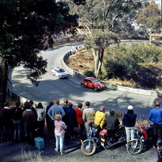
Don’t believe it? Well we have a copy of almost every one of the nineteen reports, and these are just the ones we know about. This revelation comes after being a member of one of the longest lasting environmental groups in the Blue Mountains region, ‘The Friends of Katoomba Falls Creek Valley Inc.’ which lasted for 28 years initially forming informally in 1988 to protest and lobby against the Catalina Raceway from 1988 incensed by Bob Jane’s helicopter buzzing low over residents’ homes around what was then Catalina Park. Over the span of half a lifetime, The Friends fought many a campaign against a host of environmental threats to the valley/gully and amassed a considerable record of material during that period.
The following is our list of the planning reports into The Gully:
List of Plans for The Gully, so far…
Katoomba Falls Creek Valley Environmental Study A & B (date TBA)
FWP – ‘Bushland Management and Report’, (date TBA)
Frank Walford Park Master Plan for Development 1955 (car racetrack), by Katoomba Municipal Council
Draft Assessment of Frank Walford Park, Katoomba – Land Suitability, Environmental Constraints, circa 1980
Frank Walford Park Management Plan 1981, 54 pages
Katoomba Falls Creek Valley by Neil Stuart (provided to Wentworth Falls TAFE Library on special reserve), 1988 and revised in 1991
Katoomba Falls Reserve Draft Plan of Management, Volume 1, by Mandis Roberts Consultants for Blue Mountains City Council and the NSW Department of Lands, April 1990 (possibly a Volume 2 as well)
Katoomba Falls Creek Valley Environmental Study – Part 1 (Draft Report and Management Plan of 87 pages) and Part 2 (Technical Reports, Data and Analysis of 55 pages) by Fred Bell of F.& J. Bell and Associates Pty Ltd and Dr Val Attenbrow, June 1993
The Gully Archaeological Grant Project, 16th August 1995
‘Katoomba Falls Creek Valley Draft Plan of Management – Main Report’, by Des Brady of Connell Wagner Pty Ltd, of approximately 150 pages, April 1996
Frank Walford Park Plan of Management, December 1998
Upper Kedumba Valley, Katoomba – Report on the cultural significance of Upper Kedumba Valley for declaration as an Aboriginal Place prepared by Dianne Johnson with Dawn Colless for NPWS, 162 pages, 3rd July 2000
Draft Katoomba-Leura Vegetation Management Plan by Blue Mountains City Council, December 2000, 46 pages,
Upper Kedumba River Valley Plan of Management (The Gully Aboriginal Place – Council Revised Edition, (Spiral Bound, 105 pages) by Environmental Partnership, February 2004
Final Report for Sydney Catchment Authority – Catchment & Improvement Grant No. 44 Upper Kedumba River Vallkey, prepared by members of Kedumba Creek Bushcare 7 Blue Mountains City Council March 2005, 27 pages.
A Heritage Study of the Gully Aboriginal Place, Katoomba, New South Wales by Allan Lance of Heritage Consulting Australia Pty Ltd August 2005 (2 versions – a detailed confidential version for the local Aboriginal peoples and a second summary version for Blue Mountains City Council, 113 pages)
Construction Environmental Management Plan – Blue Mountains Sewer Trunk Mains Amplification: Upper Kedumba River Valley, South Katoomba Sewerage Catchment by Total Earth Care Pty Ltd for Sydney Water and Blue Mountains City Council, 17th October 2007, approximately 50 pages.
Reconnecting to Country – Progress Report #2 by Rouse Water, Council, Gully Traditional Owners, Sustainable Futures Australia, Widjabul Custodians, September 2009. (possibly a Progress Report #1 as well)
The Gully Aboriginal Place Draft Plan of Management 7th May 2021, by Soren Mortensen and Brad Moore, Blue Mountains City Council, 142 pages.
As Council currently prepares its final version of its 2021 plan version for The Gully, the obvious critique we posit to Council is that it is about time Council actually focuses on implementing its plans rather repeatedly spending money having more plans written.
We point out that the only plan on The Gully that Council has funded out of its budget (ratepayers’ money) and not from external grants was the construction of the racetrack in 1959. And then the funding was a loan to the then Blue Mountains Sporting Drivers’ Club Ltd, a collection of wealthy local business men who persuaded Council to bulldoze the homes of the poor residents so they could race cars on a new racing circuit.
Catalina Park Raceway operated officially from 1961 to 1971 when the organisation running it, the Blue Mountains Sporting Drivers Club went into liquidation.
Council’s loan was in excess of £20,000 (say a conservative $40,000 equivalent at the time, since at the Australian government’s switch to decimal currency back in 1966 set the conversion rate of $2 to being equivalent to £1 (Australian).
[SOURCE: Minutes of Special Meeting of the Council (duly convened) , Tuesday 13th day of January 1959, page 8, Item 45, signed as validated by the Mayor and Town Clerk and verbatim thus:
“Car Racing Track – Catalina Park, Katoomba. Page A12 Town Clerk’s Report.
Resolved on the motion of Alderman K. Smith and W. Smith that consideration be given when dealing with the Loan Estimates for 1959/60 to the inclusion of an amount of about £20,000 for the construction of a blacktopped surface to the racing track and the provision of adequate safety fencing.”
In today’s value that $40 000 would be valued at about $700,000 in today’s money in 2022. That budget excludes the costs of Council’s contracted bulldozer work to demolishing The Gully homes, then grade the new racetrack circuit, or the deforestation, or the construction of the changing sheds beside the lake, or the red brick toilet block inside the track circuit, or the addition of the dirt Rallycross circuit or the other racing infrastructure.
That ratepayer loan by Council to the Blue Mountains Sporting Drivers’ Club Ltd was never repaid. The opportunity cost of ratepayers’ wealth for more vital needs of the Blue Mountains would have been considerable. It was an indulgence by certain councillors and their wealthy business mates and off-Mountains petrol heads to provide an exclusive hobby. It was all bugger The Gully residents and the surrounding local residents with the decades of thunderous racetrack noise in the process. Whilst the official racing ended in 1971, unofficial racing continued to 2002 when The Gully was gazetted an Aboriginal Place. But the illegal motor racing persisted for another three years until up to December 2005 – The Habitat Advocate as a local has records to support this.
Irresponsibly, council management and councillors at the time were mindful of Council’s massively over-indebtedness to the tune of £155,460 (excluding Electricity debts). Records show that Council at the time had been threatened by legal action to withdraw its claim for loan recovery. So likely due to Council’s then dire indebtedness at the time, Council cowered, backed off and wrote off racing track loan to its business mates.
The Gully in Katoomba – yet another vacuous draft Plan of Management by Council, 7 May 2021
A Brief Background
Back in 2004 a Plan of Management was published for The Gully in Katoomba by its government custodial owner Blue Mountains Council (Council). This followed three years of Council delegating an off-Mountains consulting firm ‘Environmental Partnership‘ (Ultimo-based) to research and draft an expensive and length report of some 105 pages.
This 2004 Plan followed a host of previous studies, reviews and reports including ‘The Bell Report’ of 1993 – its correct title being ‘Katoomba Falls Creek Valley Environmental Study‘ of some 87 pages undertaken by environmental consultants F. & J. Bell and Associates Pty Ltd. This plan in 1993 had been commissioned by local Katoomba environmental activist group ‘The Friends of Katoomba Falls Creek Valley Inc.‘ (1989-2016) thanks to a $10,000 government grant which was the cost of this very details and independent study into Katoomba Falls Creek Valley, which was Council’s official name of The Gully at the time. For more information on this study please refer to the Further Reading reference section at the end of this article.
The Gully’s evolving names
Note that the term ‘The Gully‘ was first officially applied to this creek valley in Katoomba by Council in the 2004 Plan of Management. This is the 2004 Plan -was ridiculously long title of 16 words verbatim as:
‘UPPER KEDUMBA RIVER VALLEY Plans of Management Covering the Community Lands within “The Gully” Aboriginal Place’.
Put that up your jumper! Here’s the original for reading, download and printing in the public domain:
It followed That draft document was entitled, which is an affectionate term used by former residents and their descendants from the 1950s and generation prior. Other terms for The Gully have been:
‘Blacks Camp‘ (a colonial disparaging term [1870s up to the 1950s] as cited in the book ‘Artificial Horizon – Imagining the Blue Mountains’, p.198, by Martin Thomas, 2004) (being the northern section)
‘Katoomba Falls Creek Valley‘ (being the entire 70+ hectare creek valley of riparian bushland area still not yet sold off by Council for housing)
‘Frank Walford Park‘ (being also the northern section)
‘Walford Park’ (being also the northern section without Cr Walford’s first name ‘Frank’)
‘McRae’s (horse) Paddock‘ (being the central section)
‘Selby Street Reserve‘ (being the central section’s eastern side watercourse creek gully from a spring at now Hinkler Park)
‘Katoomba Falls Reserve Cascades section‘ (being the same central section’s eastern side watercourse creek gully from a spring at now Hinkler Park)
‘Catalina Park‘ (being the northern section named by Council in the late 1950s on behalf of the Blue Mountains Sporting Car Club Ltd)
‘Upper Kedumba River Valley‘ (being the entire creek valley as renamed by Council in 2002)
‘Katoomba Falls Reserve’ (being the southern section dominated by two grass ovals named by Council)
‘The Gully Aboriginal Place‘ (being a lesser portion of the entire 70+ hectare creek valley of riparian bushland, since many bushblocks of what as Community Land has been sold off for housing, or else rezoned or proposed for rezoning so that Council’s coffers can be boosted by land sales for more housing)
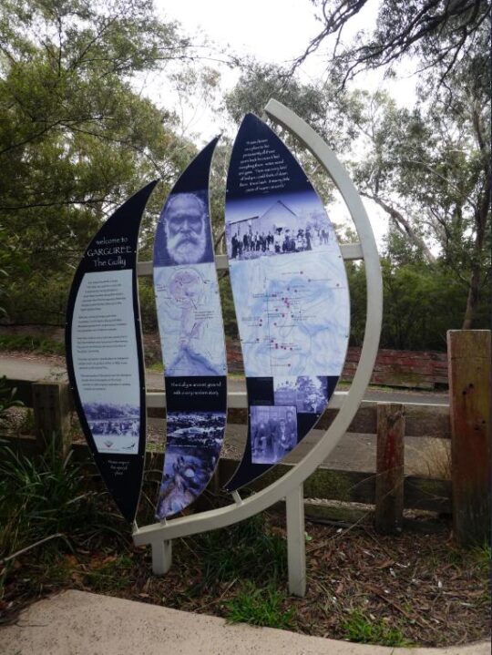
‘Garguree‘ is apparently a regional Gundungurra Aboriginal word meaning ‘gully’ which was purportedly provided by a local historian into Blue Mountains Aboriginal heritage Jim Smith PhD acting as a consultant to The Gully Traditional Owners (group) circa 2007.
Of note, two significant side watercourse gullies flowing into The Gully from the west are excluded from The Gully’s geographic scope by Council’s mapping.
One side watercourse flows into The Gully through a very large bushland/riparian zone side gully having a land title address of 21 Stuarts Road, Katoomba. The second to the south flows through what was clear-felled bushland/riparian zone and then bulldozed, graded and fertilized into the now defunct Katoomba Golf Course which Council had backed financially. This year the site of the old Katoomba Golf Course is being prepared by Council, external consultants again enticing two universities to develop it as believe it or not a ‘Planetary Health Leadership Centre‘ – how hypocritical on a site of ecological destruction!
Recalling the 2004 Plan of Management and its drafting, despite many efforts by locals expressing a keen desire to constructively engage with Council to provide input into this Plan, Council arrogantly shunned these requests, so very little local community consultation went into this 2004 Plan.
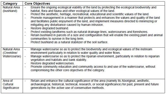
On page 101 under the sub-heading ‘Review of the plan of management‘ it reads as follows:
“It was the intention of the authors (Environmental Partnership) that the progress of implementation should be assessed by Council on an annual basis in terms of the performance measures described in Table 7 and updated or reviewed as appropriate. It was also outlined in the plan of management that a more comprehensive review should be made after five years to assess the effectiveness of the plan and need for review.”
This is the Table 7:
Well, neither the annual assessment of progress nor the five year review took place. None of the core objectives has been achieved by Council since 2004 (nor prior from the Bell Report of 1993) and it is now 2021.
From our experience over the past twenty years as local activists to save and protect the ecology of The Gully, Council’s ongoing neglect and abuse of The Gully has persisted and particularly Council management’s disdain for local Bushcare volunteers to altruistically request Council to commit to caring for and rehabilitating The Gully’s natural ecology after decades of harm.
It has taken until 2017 for Council to finally get around to reviewing its 2004 Plan of Management after some thirteen years, because Council was legally required to undertake a formal review of the 2004 Plan of Management – still pending in 2021…
“in accordance with the requirements of the Local Government Act 1993 (NSW) and the Crown Land Management Act 2016, and the Office of Environment and Heritage (OEH) Declared Aboriginal Place Guidelines for Development Management Plans.”
The 2021 Plan has been prepared by Council’s contracted Environmental Planning Officer Soren Mortensen and Council’s Aboriginal Community Development Officer Brad Moore is vastly different to the 2004 plan. However a quick comparison of the 2004 Plan and the current 2012 draft Plan reveals that most of 2004 Plan’s 105 pages have been ignored in the 2012 draft plan. The current 2012 draft plan reads more like a cultural document borrowed from elsewhere and applied to The Gully instead of being as a place-based plan of management for a natural place as is the 2004 plan.
Our concerns about Council’s proposed “Re-categorisation” of ‘Community Land’ in The Gully
After 20 years experience in trying to consult with Blue Mountains Council about The Gully (respecting this valley, caring for this valley and rehabilitating the valley’s neglected and abused ecology) we have learned not to trust Council management.
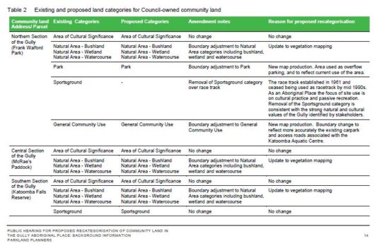
Whilst The Habitat Advocate is receptive to Council’s proposed reclassification of the current Council-owned community land specifically and only to the defunct Catalina Raceway from being a ‘Sportsground’ to being a ‘Natural Area’, this proposed reclassification is noticeably absent in the Table 2 on page 14 (copy below) of the ‘Background Information document supplied. The relevant column headed ‘Proposed Categories’ in the table is blank (“-“). Is this an oversight or intentional?
History is history, and the impost of the racetrack and motocross circuit in the northern section of The Gully back in 1957 involved Council’s forced eviction of numerous poor residents from their simple bush homes, including the violent demolition of their homes by mechanical excavators. The racetrack remnants remain since the track was ultimately shut down to vehicles permanently in 2003. We consider it is important the history of the racetrack and this traumatic story is not lost to current and future generations.
We are opposed to the remnants of the bitumen racetrack being destroyed by any excavation works, but rather the track be allowed to be significantly narrowed in width, and to be maintained to facilitate passive recreation use for following purposes:
On-Leash Dog Walking (NOT off-leash and no more mass gatherings of many dogs like the RSPCA’s annual Millions Paws Walk event that invaded The Gully back in May 2004)
Individual Cycling (NOT large groups of cyclists or organised cycling events)
Fire Truck Emergency Access (track to a maximum width of 4 metres wide) in order to facilitate the extinguishing of a bushfire (NOT RFS bush arson/‘hazard reduction’). NB. The original racetrack width was at least 10 metres wide and has since has the natural bushland retake the invasive bitumen.
Other Passive Uses – such as interpretation and for cultural purposes by the local Aboriginal peoples.
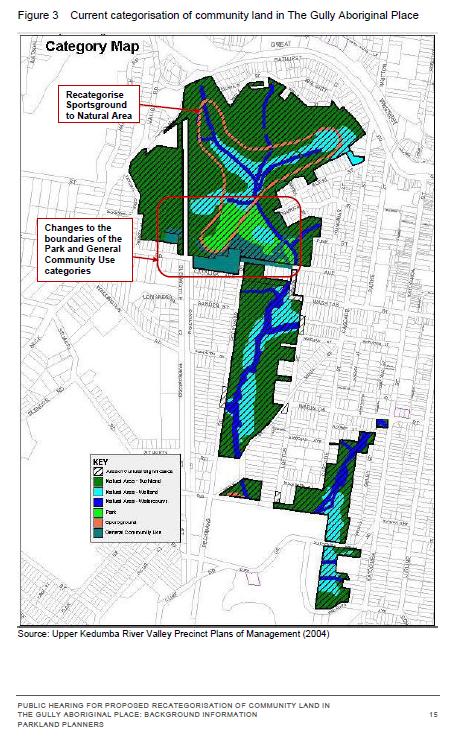
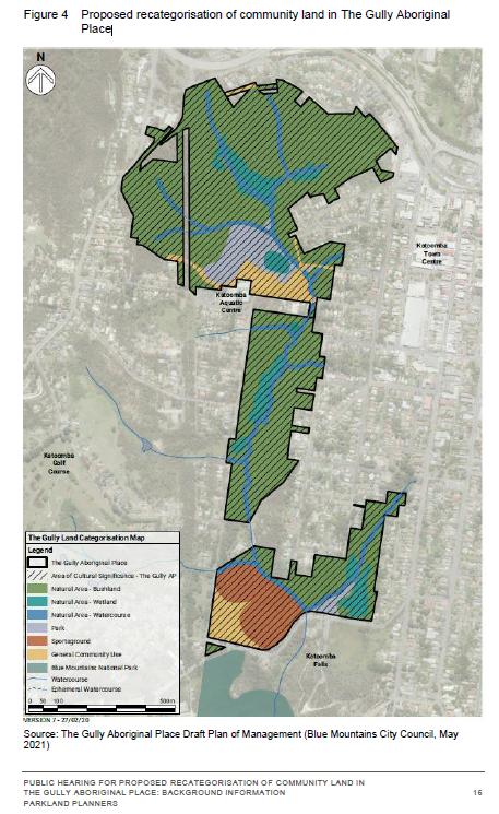
However, we are otherwise opposed to Council’s proposed reclassification of the Council-owned community land in The Gully because there are numerous land parcels shown in the supplied mapping on Page 16 (copy below) that indicate their removal from the current community land categorisation shown on page 15 (copy below). The fear is that this removal will result in Council’s selling the excludes land parcels for housing development and so again profiteer from The Gully as it has in the past.
We also opposed Council’s proposed reclassification because the supplied mapping scale (approx. 1:10,000) is too small a scale ratio to read and to discern the boundary changes accurately. A more readable map scale ration would be 1:5,000 and we request that Council provide this to all registered stakeholders included in:
Council’s Public Hearing for Proposed Re-categorisation of Community Land in The Gully (2021)
Council’s supplied mapping is also obscure. Whereas the supplied map for the current categorisation (Figure 3 on page 15) is cadastral (that is, shows land parcels) and is overlayed with colour-coded categorisations; the supplied map for Council’s proposed re-categorisations is an aerial photo with the colour-coding overlay in heavy bold which makes it impossible to read accurately. The comparisons between the two map styles are also difficult to discern.
Council’s exclusion of multiple bushland sites from ‘Community Land’ status (protection)
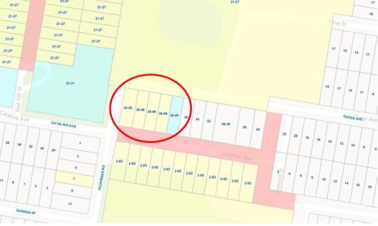
Based upon a quick comparison of the two maps, we have concern for the following identified land parcel proposed for removal from current Council –owned Community Land included within The Gully Aboriginal Place, and we ask Council what it the justification and have explanation before this 2021 Draft Plan of Management goes before Council to be approved.
This site is the bushland block across the road from the Katoomba Sports and Aquatic Centre which covers about a hectare at address 34-46 Gates Avenue.
This natural bushland block significantly represents one of the last natural landscapes interconnecting The Gully between the northern section and the central section. It must be naturally preserved intact as part of The Gully’s Community Land zoning (land categorisation).
Close inspection of Council’s proposed re-categorisation of Community Land map, shows that this site has been excluded from Council’s Community Land in The Gully Aboriginal Place. The logical presumption is that Council intend to rezone it ‘Operation Land’ so Council can then legally sell the hectare off to private land use developers into for or five housing lots. So the bushland gets bulldozed and Council management profiteer with a million dollar bounty.
On the above bases, we reject Council’s current (2021) proposed re-categorisation of Council-owned community land in the Gully.
Our concerns above were contributed by The Habitat Advocate to Council in its dedicated Public Hearing held via Zoom online software on Saturday 7th August 2021 as well as with a follow up email dated 12th August 2021 to Council’s delegated Environmental Planning Officer Soren Mortensen. However, no acknowledgement of that email has been received from Council.
We have sourced land title mapping of The Gully Water Catchment from Google Maps dated 2021. There are six maps that cover the water catchment extent of The Gully extending from the Cox’s watershed (Great Western Highway) in the north, down through what was Frank Walford Park and Catalina Raceway, as well as the side watercourse through Selby Reserve (from Hinker Park), and the two watercourses that flow from the west and then to Katoomba Falls Reserve and to Katoomba Falls itself.
We have compared Council’s proposed land re-categorisation map (Figure 4 above) with the land titles on these six mapped sections from Google Maps, and placed an ‘X’ on each identified the land parcel that are bushland within The Gully but which have been excluded in Council proposed recategorisation.
Not all these bushland lots are Community Land, but many are. Bushland and swampland land parcels that are categorised by Council as ‘Community Land’ are generally protected from land use development. However those bushland and swampland land parcels that are excluded from Council’s colouring in Figure 3 above, are NOT protected. Council could then easily rezone them as ‘Operation Land’ which is the next stage before selling them off for housing development. Council has a record or doing this throughout the Blue Mountains local government area over decades, including on the periphery of the Gully.
What we wish to illustrate here in these six maps is the scale to which the bushland amenity risks being destroyed for likely housing development and so alter the natural amenity of The Gully forever.
Each map below is in Adobe Acrobat (PDF). We allow for each map to be zoomed into so as to enable enlarging the map on the screen via Google Docs (free software), as well to be downloaded and printed.
[1] The Gully Report No. 8, ‘Katoomba Falls Creek Valley Environmental Study‘, published in 1993, by F.J. Bell and Associates Pty Ltd, (Fred Bell), Sutherland NSW, contains 87 pages in A4 spiral softcover binding, (available internally on this website) >https://www.habitatadvocate.com.au/gully-report-no-8-the-bell-report-of-1993/
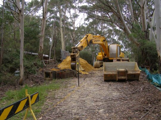
Excavator in The Gully getting stuck in with Council approval. We don’t forget. This is comparable of how Council forcibly evicted the original residents back in 1957. (Photo by Editor Sunday 17th February 2008).
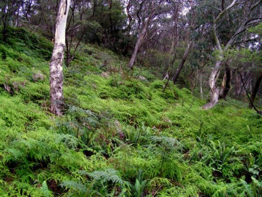
An upland swamp in The Gully sustained by irregular rain but more critically by reliable underlying groundwater that permeates year round filtered through the sandy loam substrate atop impervious sandstone bedrock. Photo by Editor years ago.
“The Bell Report” dated June 1993 was the first professionally academic study and report (environmental and archaeological) into Katoomba Falls Creek Valley, which subsequently is referred to as ‘The Gully’ by former residents and their descendants, of whom we greatly respect.
The Bell Report’s correct title is ‘Katoomba Falls Creek Valley Environmental Study‘ and was published in printed form as an A4 sized spiral binder of some 87 pages in length and in budget black and white.
This landmark environmental study included the first Environmental Management Plan outline for the Valley/Gully based upon the findings of the detailed study. The ground-based/evidence-based field study was undertaken over twelve weeks in 1992 by qualified and experienced environmental consultants F. & J. Bell & Associates Pty Ltd who was based in the Sydney suburb of Sutherland. The principal consultant was the late Dr Fred Bell BSc MSc PhD MEIA (1932-2009). [Ed: MEIA stood for Member of the Environment Institute of Australia, which was subsequently renamed to the Environment Institute of Australia and New Zealand (EIANZ). More info: ^https://www.eianz.org/]
Dr Fred Bell sadly passed away in 2009. More about Fred can be garnered by an obituary article written in The Sydney Morning Herald of that year – refer to our ‘Further Reading‘ appendix at the end of this article.
This first study into The Gully by Dr Fred Bell was commissioned by local Katoomba-based environmental activist group ‘The Friends of Katoomba Falls Creek Valley Inc.’ (‘The Friends’). It was thanks to this local resident group of Katoomba successfully applying for a $10,000 NSW Government grant for this landmark environmental study to be undertaken. Members of The Friends subsequently referred to this report affectionately just as ‘The Bell Report‘ after its lead author Dr Fred Bell. Further details are explained on Page i of the Executive Summary.
Assisting Dr Fred Bell received considerable field and investigative research contribution in this study specific to the local Aboriginal archaeological connection to The Gully by anthropologist Dr Val Attenbrow BA (Hons), PhD, who compiled Section 14 in Part 2 of this study. However, given the sensitive nature of that research which we hold we consider it prudent not to publish this or Part 2 of the study on this website.
Dr Fred Bell was known to ‘The Friends’ founder and leader, the late Neil Stuart BSc. (1937-2016), both environmental science graduates from The University of Sydney during the 1960s, who perhaps knew each other prior. Neil lived on the edge of the valley/The Gully.
For the benefit of the local community in and around The Gully catchment, we herein reproduce only Part 1 of this report of this study in its 87 page entirety, section by section. In the context of the many studies and reports into The Gully, this Bell Report was the eighth such plan/report. We replicate it below on this website in the public domain under Creative Commons copyright license type ‘Attribution-Non-Commercial’ [CC BY-NC]. This means that anyone is free to download it and print it and use it for non-commercial purposes in the interests of the natural rehabilitation of The Gully in Katoomba.
Upon this study (Part 1 and Part 2) being presented by Dr Fred Bell to The Friends of Katoomba Falls Creek Valley Inc. (The Friends) in June 1993, The Friends formally submitted the complete report to the General Manager of Blue Mountains City Council soon after.
Council did absolutely nothing with it and just filed it. Despite many years of The Friends seeking dialogue to act on the study’s recommendations and to establish a local community-based management consultative process with Council, Council shunned and ostracised The Friends continually over 28 years (1988-2016).
There have been some nineteen plans/reports into The Gully at the time of writing this article. Very little has been done on the ground in The Gully over the decades by Council despite Council being the supposed custodian of all the public/community lands within the Gully.
‘Fred Bell wanted to save the world. He lectured in climatology and environmental science around Australia and in other countries, worked for environmental action groups and put his ideas into practice by building eco-friendly houses ahead of their time and growing and eating native plants before it was fashionable.
Frederick Charles Bell was born in Sydney on September 12, 1932, the first of three sons of Charles Bell and his wife Edna Taylor. Charles had been orphaned at eight and was made a ward of the state, the advantage being that he was given a good education and with that went on to be a successful businessman.
A life dedicated to saving the planet … Fred and Joan Bell with their seven grandchildren.
Fred’s academic ability was soon recognised. He went from Rockdale Public School to the Erskineville opportunity classes and won a bursary to Canterbury Boys High, then selective.
He was an enthusiastic Boy Scout and later became a scout leader. He was also a talented middle-distance runner and later ran in almost every City to Surf race.
After marrying his bushwalking companion, Joan Mayman, an accountant, in 1959, Bell studied science and mathematics at the University of Sydney. After taking his bachelor degree in 1962, he moved to the University of NSW to do a masters in civil engineering in 1965 and a PhD in the mathematical modelling of natural processes in 1974. He started lecturing at the University of NSW in 1970 and by 1972 was a senior lecturer in climatology, geomorphology, biogeography and environmental science.
Dr Bell pursued a wide range of research projects while he was teaching. He was a passionate teacher, bridging the gap between hydrology and climate and in later years championing the introduction of study units in environmental impact analysis. These were the first of their kind in Australia and were a mixture of legal, social and physical science, including the useful art of writing environmental impact statements.
He also, at various times, worked with the University of Newcastle, the Department of Works in Darwin, the CSIRO in Brisbane and Cairns, Florida State University, Colorado State University and the University of East Anglia.
His research contributed significantly to environmental causes such as gaining world heritage listing for North Queensland rainforests, preserving forest ecosystems in NSW and restoring water to the Snowy River and the Macquarie Marshes. His mathematical models for predicting local convective rainfall were successfully adapted by India and several developing countries.
The three family houses that he and Joan designed and built contained ”contraptions” often ahead of their time to help the environment. They all had such innovations as passive solar energy design, compost heaps, worm farms and tanks to recycle waste water, and were often out of character in their areas.
In 1972, Bell joined the management committee of the newly formed Total Environment Centre and remained a member for more than 20 years. There in the 1980s he worked on a study of which NSW forests should be preserved and worked with the centre’s wildlife in peril group to make the first national list of endangered species.
He was on call for the Sutherland Shire Environment Centre from its beginning in 1991 and was also a foundation member of the Community Environment Network on the Central Coast.
Bell stayed at the University of NSW until 1989 then retired to form his own business with Joan, F & J Bell and Associates, an environmental and horticultural consultancy firm. In later years, he focused more attention on climate change, using his expertise in climatology to explain the science of climate change to the public.
He loved cooking and eventually took over the household cooking and shopping. He was always experimenting with new combinations of foods (such as peanut butter, alfalfa sprout and salmon sandwiches) and was highly knowledgeable about bush tucker. Visitors were likely to be offered snacks of cheeky yam, pig face, lemon myrtle, exocarpus, lilli pilli and bunya nuts.
Bell told friends that 2007 was his ”Eureka year” because decades of research and thought had coalesced as a vision of a new applied science, which he called ”pronomics”. It was a revision of mainstream economics with the aim of creating ”ethical economics” or ”sustainable economics” to satisfy present human needs without harm to humans or other life. Bell believed that pronomics would make responsible decision-making possible and address serious global problems such as climate change with scientific predictive techniques.
Bell continued his work all his life and died suddenly, leaving behind extensive notes for books he had planned to write when he had time.
Fred Bell is survived by Joan, their children Heather, Greg and Fiona, seven grandchildren and his brothers Graeme and Rodney.’
"We're coming to you from the custodial lands of the Hairygowogulator and Tarantulawollygong, and pay respects to uncle and grandaddy elders past, present and emerging from their burrows. So wise to keep a distance out bush."