Posts Tagged ‘World Heritage’
Saturday, November 15th, 2014
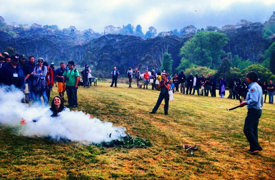 Smoking Ceremony or Smoke and Mirrors?
Staged for the delegates by National Parks and Wildlife Service of New South Wales (NPWS), somewhere outside Sydney, Australia
[Source: ‘Global First Nations environmentalists share stories at the World Parks Congress in Sydney.5:30’, ^https://twitter.com/nitvnews, 20141113] Smoking Ceremony or Smoke and Mirrors?
Staged for the delegates by National Parks and Wildlife Service of New South Wales (NPWS), somewhere outside Sydney, Australia
[Source: ‘Global First Nations environmentalists share stories at the World Parks Congress in Sydney.5:30’, ^https://twitter.com/nitvnews, 20141113]
.
Every ten years a World Parks Congress is a forum staged by the International Union for Conservation of Nature to discuss the effectiveness of World Heritage Listed Protected Areas. For 2014, Parks Australia put up Sydney’s hand to host and fund it.
<<“We (Parks Australia) are delighted to be co-hosting the IUCN World Parks Congress with our colleagues in the New South Wales National Parks and Wildlife Service – and look forward to welcoming inspiring leaders from around the world.”>>
IUCN’s vision is a “just world that values and conserves nature.” The theme for the 2014 conference is “Parks, people, planet: inspiring solutions”.
The last congress was in Durban, South Africa eleven years ago in 2003 and significant messages from that congress were that:
- Considerable progress has been made in the establishment of protected areas although significant gaps remain
- Protected areas face many challenges, and management effectiveness must be strengthened
- Protected areas play a vital role in biodiversity conservation and sustainable development
- A new deal is needed for protected areas, local communities and indigenous peoples
- There is a need to apply new and innovative approaches for protected areas, linked to broader agendas
- Protected areas require a significant boost in financial investment
- Protected areas management must involve young people
.
Congress Cost Benefits ?
.
The obvious first question for the 2014 Sydney Congress is what are the outcomes from these seven messages of 2003?
The second question is what is to be the conservation return on investment of staging the 2014 congress in Sydney? That starts with Parks Australia and NPWS disclosing the full costs of the congress. How much will it have cost by the time this week is over? Five million? Ten million? Twenty million? More? That also involves disclosure of the onground conservation outcomes, if any. The congress hosts more than 5000 delegates for a week-long event in Sydney.
If the answers are not forthcoming and/or the performances less than satisfactory, then perhaps the money could have been better spent (invested) by Parks Australia and NPWS on specific onground conservation of current and worthy Protected Areas in Australia. So the third question is what is the opportunity cost of the 2014 IUCN World Parks Congress which could have delivered the IUCN vision of a “just world that values and conserves nature”?
.
Congress Opportunity Costs
.
According to IUCN director general, Julia Marton-Lefevre, assessments during the past decade have found that half of the world’s protected areas at best — and possibly as few as 20 per cent — are managed effectively. “Some are what we refer to as ‘paper parks’ ” – parks just on paper.
The Australian Government’s $180 million allocation to expand the park reserve system expired last year.
The Great Barrier Reef Marine Park is a case in point. It is the iconic Protected Area in Australia. Its World Heritage listing along with various national zoning, management plans, permits, education and incentives are supposed to protect and conserve the marine ecosystems and migratory species from human threats. But farm and urban runoff continues to contaminate the rivers that flow into the Reef.
In 2009 and 2011, mining company Queensland Nickel discharged nitrogen-laden water and 516 tonnes of toxic waste water into the Great Barrier Reef.
On 21 July 2013, on the second day of the biennial joint training exercise Talisman Saber, two American AV-8B Harrier fighter jets launched from aircraft carrier USS Bonhomme Richard (LHD-6) dropped four bombs, weighing a total 1.8 metric tons (4,000 pounds), into more than 50 metres (164 ft) of water. On 3rd April 2010, The Shen Neng 1, a Chinese ship carrying 950 tonnes of oil, ran aground, causing the 2010 Great Barrier Reef oil spill.
In December 2013, Greg Hunt, the Australian environment minister, approved a plan for dredging to create three shipping terminals as part of the expansion of an existing coal port. According to corresponding approval documents, the process will create around 3 million cubic metres of dredged seabed that will be dumped within the Great Barrier Reef Marine Park.
On 31 January 2014, a permit was issued to allow three million cubic metres of sea bed from Abbot Point, north of Bowen, to be transported and unloaded in the waters of the Great Barrier Reef Marine Park, just outside of Abbot Bay. The dredge spoil will cloud the water and block sunlight, thereby starving sea grass and coral up to distances of 80 km away from the point of origin due to the actions of wind and currents. The dredge spoil will smother reef or sea grass to death, while storms can repeatedly resuspend these particles so that the harm caused is ongoing; secondly, disturbed sea floor can release toxic substances into the Great Barrier Reef Marine Park.
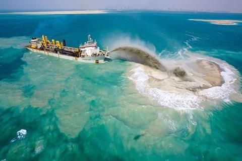 Dredging the Great Barrier Reef for bulk export shipping Dredging the Great Barrier Reef for bulk export shipping
.
The Great Barrier Reef Marine Park has become just a blue line on a map. The trickle of funds for Australia’s national parks betrays a lack of appreciation of their economic contribution. Annual funding for the authority that runs Australia’s most famous reserve, the Great Barrier Reef Marine Park, is about 1 per cent of the $5.2bn it earns the country in tourism revenue.
Yet if the IUCN World Parks Congress cost a conservative $20 million to stage then a key opportunity cost would be the June 2014 Federal budget cuts to the Great Barrier Reef Marine Park Authority.
The budget axed 17 staff including five of its’ directors positions. These positions included the director of heritage conservation, the director of policy and governance and the director of coastal ecosystems and water quality as part of an internal restructure. It’s being described as the greatest loss of expertise from Australia’s most important natural wonder and it comes at the very time the Great Barrier Reef is facing the greatest threat to its survival.
The Greater Barrier Reef Marine Park Authority has been reduced by the Australian Government to being in name only and ineffective at protecting the reef.
Until recently, one of those five directors, Adam Smith, was charged with dealing with the contentious Abbot Point coal terminal development and the proposal to dump three million cubic metres of dredge spoil into the marine park. Despite Dr Smith’s concerns, the sea dumping was approved by the Marine Park Authority.
Dr Smith has since accepted voluntary redundancy and moved on after disagreeing with the Authority’s new economic leadership and values. Heritage conservation director Jon Day has left after 21 years, disillusioned too with the direction the Authority has taken to compromise the reef.
Next year UNESCO will decide whether to put the reef on its world heritage in danger list. Native Dugongs are already endangered. The deliberate extermination of the dugong and turtles which habituated the Gladstone area is a national tragedy. Dugongs are species listed under the Federal Environment Protection Biodiversity & Conservation Act, which requires the Federal government to legally protect these animals.
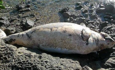
Prior to the massive dredging operation of 52 million cubic metres of seabed for the development of the world’s largest LNG Terminal, ( which is 62% completed) a study commissioned by the Gladstone Ports Corporation found that a take, or a quota, of more than zero dugongs would be unsustainable.
In the face of massive mortality of dugongs, turtles and inshore dolphins during the ongoing massive dredging, both the Federal and Queensland governments ignored the slaughter.
Look at the stranding data from the Queensland Department of Environment and Resource Management. Monthly cumulative Dugong strandings by year for Queensland, up to 31 January 2012.
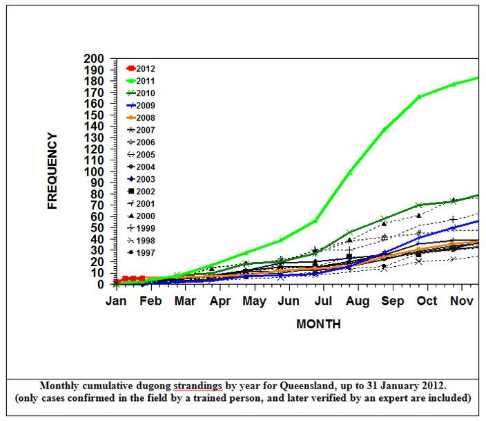
There are 22,000 vessel movements a month in Gladstone Harbour. No ship strikes of Dugongs or of Green Turtles need to be reported. No audit of environmental conditions has been undertaken by the Queensland or Federal Governments. The wholesale slaughter of our marine wildlife is the price Australians are paying for the transformation of the Great Barrier Reef World Heritage Area into the world’s largest unregulated quarry.
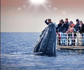 Mass tourism operators good for the economy
Getting up close to protected Humpback Whales within their 100 metre Protected Area Mass tourism operators good for the economy
Getting up close to protected Humpback Whales within their 100 metre Protected Area
.
Australian protected areas have seen rule changes in the eastern states have allowed cattle to graze, recreational shooters to hunt and hotel developers to build in national parks. Shore-based recreational fishing has been allowed in areas of NSW marine parks previously zoned as no-take sanctuaries. National parks on land and in the ocean are dying a death of a thousand cuts, in the form of bullets, hooks, hotels, logging concessions and grazing licences.
Yet as host of the 2014 World Parks Congress, Australia is showcasing “our own inspiring places, inspiring people and inspiring solutions.” The Global Eco Forum within the Congress programme focuses on tourism exploitation of Protected Areas because like the new Greater Barrier Reef Marine Park Authority, the new values are not about conservation by the billions in revenue opportunity to Australia’s economy.
The October 2006 issue of National Geographic published an article “The Future of Parks: Hallowed Ground – Nothing is Ever Safe”.
It stated:
“Landscape and memory combine to tell us certain places are special, sanctified by their extraordinary natural merits and by social consensus.
We call those places parks, and we take them for granted.”
.
Sydney’s 2014 World Parks Congress appears to be expensive window dressing, showcasing fraudulent conservation of Protected Areas in Australia.
It’s termed Greenwashing. The opportunity cost of the 2014 Congress could have instead funded the retention of the previously effective Great Barrier Reef Marine Park Authority and so done more for Protected Areas than all the pomp, promising, luncheons, showcasing, and talk-festing of the congress combined.
.
 Protest to stop Queensland Resources Council dumping dredge spoil inside the Reef
Protest by Cairns and Far North Environment Centre (CAFNEC), June 2014
^http://cafnec.org.au/wp-content/uploads/2014/03/rally-promo-photo.jpg Protest to stop Queensland Resources Council dumping dredge spoil inside the Reef
Protest by Cairns and Far North Environment Centre (CAFNEC), June 2014
^http://cafnec.org.au/wp-content/uploads/2014/03/rally-promo-photo.jpg
.
Further Reading:
.
[1] IUCN World Parks Congress (Sydney 2014), International Union for Conservation of Nature, ^http://worldparkscongress.org/
.
[2] ‘Global Eco-Tourism in Protected Areas‘, by EcoTourism Australia, >2014 Global Eco Tourism in Protected Areas.pdf (1.1MB, 2 pages)
.
[3] Great Barrier Reef Marine Park Authority (website), Australian Government, ^http://www.gbrmpa.gov.au/
.
[4] Fight for The Reef (website), Australian Marine Conservation Society, ^https://fightforthereef.org.au/risks/dredging/
.
[5] No Hunting in National Parks (website), The National Parks Association of NSW, ^http://nohunting.wildwalks.com/
.
[6] ‘An international perspective on tourism in national parks and protected areas‘, by J.G. Castley (2014), >An international perspective on tourism in national parks and protected areas.pdf (100kb, 10 pages)
.
[7] ‘EXTRA: ‘Nasho’, Royal National Park, Sydney’s neglected southern jewel‘, by Nick Galvin, Journalist, Sydney Morning Herald, 20140613, ^http://www.smh.com.au/nsw/extra-nasho-royal-national-park-sydneys-neglected-southern-jewel-20140613-zs6d8.html
.
[8] ‘Paradise lost: Australia’s heritage jewels under threat‘, (audio), ABC ‘Background Briefing’ radio programme, by Sarah Dingle, 20131208, ^http://www.abc.net.au/radionational/programs/backgroundbriefing/2013-12-08/5132224
.
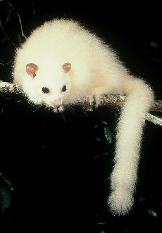 White Lemuroid Possum
(Wet Tropics of Queensland World Heritage Area in Danger)
Has the white lemuroid possum become the first mammal to go extinct due to global warming? White Lemuroid Possum
(Wet Tropics of Queensland World Heritage Area in Danger)
Has the white lemuroid possum become the first mammal to go extinct due to global warming?
The species, normally found above 1000m, has not been sighted during any nighttime spotlighting expedition since 2005. Experts fear a temperature rise of 0.8 degrees Celsius may be to blame for the animal’s disappearance.
[Source: ^http://www.wherelightmeetsdark.com/index.php?module=newswatch&NW_user_op=view&NW_id=453]
.
Tags: Dugong, Dugong strandings, Gladstone Harbour, Great Barrier Reef, Great Barrier Reef Marine Park, Green Turtle strandings, greenwashing, Humpback Whale, International Union for Conservation of Nature, iucn, national parks, National Parks and Wildlife Service, Parks Australia, Protected Areas in Australia, Queensland Government, The Great Barrier Reef Marine Park Authority, UNESCO world heritage in danger list, Wet Tropics of Queensland World Heritage Area in Danger, White Lemuroid Possum, World Heritage, World Parks Congress
Posted in Critically Endangered Wildlife (CR), Threats from Government Funding Neglect, Threats from Greenwashing, Threats from Pollution, Threats from Tourism and Recreation, Threats from Weak Environmental Laws | No Comments »
Add this post to Del.icio.us - Digg
Thursday, November 8th, 2012
") Oxley Wild Rivers National Park
Click image to enlarge
Inscribed on the asset register of World Heritage sites in 1994…but how much has been wiped out by October’s bushfires?
[Photo Source: New South Wales Government,
^http://www.nationalparks.nsw.gov.au/oxley-wild-rivers-national-park/travel-info] Oxley Wild Rivers National Park
Click image to enlarge
Inscribed on the asset register of World Heritage sites in 1994…but how much has been wiped out by October’s bushfires?
[Photo Source: New South Wales Government,
^http://www.nationalparks.nsw.gov.au/oxley-wild-rivers-national-park/travel-info]
.
 Location of Oxley Wild Rivers National Park
Click image to enlarge – note the patchy dark green of remnant forests Location of Oxley Wild Rivers National Park
Click image to enlarge – note the patchy dark green of remnant forests
[Source: Satellite Map – Google Maps]
.
The ‘Macleay River’ Bushfire (Oct 2012)
.
 Macleay River Bushfire October 2012
– left to burn for a week from 12th Oct 2012 because not a threat to private property
..then the wind picked up…unbelievable! Macleay River Bushfire October 2012
– left to burn for a week from 12th Oct 2012 because not a threat to private property
..then the wind picked up…unbelievable!
.
Over the past month, a single contiguous area covering some 60,000 hectares of vegetation has been left to burn by bushfire. That equates to 600 km2 or roughly 25km x 25km.
Much of what has been burned is/was of World Heritage values within the included Oxley Wild Rivers National Park. This is unacceptable custodial neglect.
If this was Sydney, this is the black boxed area that would have been incinerated: Putting this 60,000ha bushfire into a Sydney urban perspective
Professional urban fire fighting would not allow 60,000 hectares of private property and human lives to burn
– such would historically dwarf the Great Fire of London. Putting this 60,000ha bushfire into a Sydney urban perspective
Professional urban fire fighting would not allow 60,000 hectares of private property and human lives to burn
– such would historically dwarf the Great Fire of London.
.
The Rural Fire Service has labelled the bushfire the ‘Macleay River Fire‘. But it began as two separate bushfires on or before 12 October, nearly a month prior. One was then labelled ‘Georges Junction Fire‘ and the other ‘Freds Creek Fire‘, both purportedly ignited by bush arsonist(s). Seven days later, the Georges Junction Fire has burnt an estimated 8,931 ha, while the then much smaller Freds Creek Fire had burnt 1,688 ha. By the time the combined bushfire was extinguished 60,000 hectares had been burned, much within the World Heritage Area..
This is yet another classic case of bushfire neglect primarily by the delegated custodians of the National Park and World Heritage Area – the New South Wales National Parks and Wildlife Service. Is this due to chronic lack of resourcing; and/or symptomatic of a disturbing rationalist culture that believes that burning Australian vegetation, even ancient rainforest, could be somehow beneficial to biodiversity.
Remote ignitions go undetected, then unsuppressed, until many days later, bushfire weather conditions worsen and the fires get out of control, combine and destroy vast areas of important Nationl Park and World Heritage.
This 2012 Macleay River Fire is like the ‘2006 Grose Valley Fires‘ of the Blue Mountains repeated to script.
.
.
The Australian Government continues to be ultimately culpable for gross neglect in failing to protect its custodial listed natural heritage.
The Rural Fire Service has learnt to avoid accusatioins of incompetence by routinely removing timely records on its websites about the operational response in the days at the start of the ignitions. Details about the timings of ignition detection and initial suppression are deliberately withheld from the public.
The following bushfire updates are mainly from second-hand news media. A notable recurring theme across these news reports is that the media interest and the target of the fire fighting effort, just like in urban fire fighting, is to save humans lives and property. This is not a bad thing, but the glaring omission is the lack of interest in suppressing the bushfire in the National Park and World Heritage.
The Rural Fire Service policy and operational strategy is such that if human lives and properrty are not directly threatened by bushfire, then a bushfire is allowed to continue burning, irrespective of whether it is burning through National Park or World Heritage. Since the Rural Fire Service has the same terms of reference as the professionaly paid New South Wales Fire Brigade, then they are essentially doing the same urban job.
The only reason the Rural Fire Service exists in less populated rural areas instead of the professionaly paid New South Wales Fire Brigade, is traditionally so that the Australian Government and New South Wales Government can save money by relying on unpaid, under-resourced volunteers. Yet the environment in rural fire fighters work in is inherently more dangerous, demanding and in need of sophisticated resources for military-speed detection and suppressions of bushfires.
.
21 Oct: Bushfire Update
.
‘Blazes burn out of control: Permits suspended as hot, dry weather hits North West’
[Source: ”Blazes burn out of control: Permits suspended as hot, dry weather hits North West”, by Wendy Spooner, Northern Leader (regional newspaper), 20121021, ^http://www.northerndailyleader.com.au/story/411057/blazes-burn-out-of-control-permits-suspended-as-hot-dry-weather-hits-north-west/]
.
 Satellite infrared image of the fire called Georges Junction inside the Oxley Wild Rivers National Park
Having already burnt out a massive 14,000 hectares and is likely to join up with the Freds Creek fire.
The active edge of the fire shows up bright yellow; the red areas are the burnt areas.
(Photo by New England RFS) Satellite infrared image of the fire called Georges Junction inside the Oxley Wild Rivers National Park
Having already burnt out a massive 14,000 hectares and is likely to join up with the Freds Creek fire.
The active edge of the fire shows up bright yellow; the red areas are the burnt areas.
(Photo by New England RFS)
.
<<Two massive bushfires in the Oxley Wild Rivers National Park were basically running unchecked yesterday because of adverse firefighting conditions, incident controller for the New England bushfire emergency, Allyn Purkiss, said.
Mr Purkiss said the two Section 44-declared fires one named Freds Creek and the other Georges Junction were likely to join up yesterday and burn out a total of 30,000 hectares in the coming weeks.
“They took a big run under strong winds (on Saturday)..The fires had started after landholder burns had got away”, Mr Purkiss said.
..The fire named Freds Creek, which started on October 12, had burnt out 3,189 hectares and was crowning at 4am yesterday, with flames jumping from treetop to treetop.
“It means it’s very uncontrollable very dangerous conditions,” Mr Purkiss said yesterday.
The RFS had been unable to aerial-bomb the fires because of gusty winds. Mr Purkiss described it as “nigh-on impossible” to water-bomb in those conditions.
Instead, RFS volunteers had concentrated on saving property. He said it was hard to tell how many homes and remote-area shacks might be affected.
“We’re still trying to come to terms with that. We could have up to 50 in the area: there are shacks all through this country,” he said.
Mr Purkiss said the other fire, Georges Junction, had already burnt out 14,000 hectares. (Ed: Same as the 2006 Grose Valley Fires).
He said conditions in the New England RFS zone were “fairly similar” to strong, gusty winds on Saturday. “The forecast is for 50km/h winds by late afternoon,” Mr Purkiss said.
No homes had been lost in either fire yet. “None that we know of,” he said. The RFS was doing a “fairly extensive reconnaissance of the area”, he said.
Three other fires one about 40km east of Guyra, one near Walcha and one near Ebor had also started since Friday.
The Guyra fire, which started on Saturday, was located in the Mt Mulligan/Wards Mistake area.
Locals had alerted the RFS to the fire, which was in “very remote country … it’s difficult to get to no roads, no trails”, Mr Purkiss said.
“I’ve tasked an aircraft to get out there today and map it and give us some intel (intelligence),” he said..
“No properties were under threat: it was burning in scrub.“
.
Mr Purkiss said he was “not sure” how much land had been burnt out he would have to wait for information provided by the aircraft crew.
The Walcha fire, called Panhandle and in the Enfield State Forest, had burnt out five hectares by the time it was contained by mid-afternoon on Saturday.
The Ebor-area fire was located “in an area we can’t get to”, Mr Purkiss said. “We’re flying to map it today,” he said yesterday.
It had also burnt out five hectares.
“Local landholders and Ebor RFS assisted in containing it,” he said.
Mr Purkiss said the New England RFS zone was unlikely to lift its suspension of fire permits today.
“While ever we have a bushfire emergency like this going, all permits are suspended we’re already dealing with enough fires, so we don’t need any more mistakes giving us grief than we already have,” he said.
Mr Purkiss said this season had already started to play out differently compared to the past three years.
In the past three fire seasons, rain had usually come along and helped extinguish any fires but this season was different, with many more periods of extended dry weather.
“In talking to the local staff, they say that this (Georges Junction) is the largest fire they have had since 2009,” Mr Purkiss said. “We’re working hard to get it done. We thank the volunteers and employers for allowing us to fight these very large fires.”>>
.
22 Oct: Bushfire Update
.
‘Macleay River fire threatens homes’
[Source: ‘Macleay River fire threatens homes’, by Victoria Nugent, The Armidale Express (regional newspaper), 20121022, ^http://www.armidaleexpress.com.au/story/410559/macleay-river-fire-threatens-homes/?cs=469]
.") Properties between Georges Junction and Five Day Creek were at threat from fire yesterday
(Photo: The Armidale Express) Properties between Georges Junction and Five Day Creek were at threat from fire yesterday
(Photo: The Armidale Express)
.
<<Fire continues to threaten properties near Oxley Wild Rivers National Park after two blazes combined yesterday.
The Macleay River bushfire had already burnt about 20,000 hectares early yesterday afternoon as more than 30 firefighters battled the out of control blaze, NSW Rural Fire Service spokeswoman Bridie O’Connor said.
The inferno may have posed a threat to properties between Georges Junction and Five Day Creek, particularly on the Carrai and Fitzroy Tablelands and on the Macleay River in the vicinity of Lower Creek and Comara, Ms O’Connor said early yesterday afternoon.
“We’re looking at a minimum of six hours before some properties might be affected,” she said. “People should expect to see smoke and fire and be alert.”
Hot and windy conditions over the weekend (20th and 21st) saw the fires at Georges Junction and Freds Creek combine.
The Georges Junction fire, near Cochrane State Forest, which started on October 12 had burnt more than 14,859 hectares and was still burning out of control when it met with the Freds Creek fire early yesterday afternoon. The fire at Freds Creek was being controlled yesterday afternoon after three State Forest groups joined the NSW Rural Fire Service to use bulldozers to create fire breaks earlier in the week.
Meanwhile, the Armidale to Kempsey Road between Waterfall Way and Bellbrook was closed on Saturday and Sunday because of the fires.
The Rural Fire Service was concentrating its efforts on establishing containment lines.
People on properties near Georges Junction and on the Macleay were urged to be alert for fire warnings.>>
.
23 Oct: Bushfire Update
.
‘Total fire bans expected back in place by Thursday’
[Source: ‘Total fire bans expected back in place by Thursday’, by Campbell Walker, Namoi Valley Independent (newspaper), 20121023, ^http://www.nvi.com.au/story/415687/total-fire-bans-expected-back-in-place-by-thursday/]
.
<<…Adverse weather conditions on Sunday hindered attempts to subdue two massive bushfires in the Oxley Wild Rivers National Park. Fire crews were reduced to protecting property on the ground and the two fires merged late on Sunday as fire crews battled from the ground to protect property, unable to water bomb due to gusty winds across the region.
The fire, now named the Macleay River Fire had burnt out 28,733 hectares as of last night, Inspector Brett Loughlin, public liaison officer for Armidale Section 44 with the NSW Rural Fire Service, said.
Mr Loughlin was expecting the fire to burn out more land.
“We’re doing some mapping now and expect it to be around that 30,000-hectare mark,” he said. He said 52 firefighters were on the ground creating firebreaks, doing backburning and helping protect the property of landholders living within a few kilometres of the fire front.
“There are properties in close proximity,” Mr Loughlin said. “The fire has flared up a little this afternoon and some embers are falling around properties in the Lower Creek area.
“No property is under threat at the moment … the fire’s not doing anything like it was doing on Saturday (when it was out of control – a day of hot, gusty westerly winds).”
Five helicopters are currently tasked to water bombing the Macleay River Fire.
Oxley Wild Rivers National Park is still shut to the public…>>
.

.
25 Oct: Bushfire Update
.
‘Arson suspected in Macleay River fire‘
[Source: ‘Arson suspected in Macleay River fire’, by Kitty Hill, Northern Daily Leader (local print newspaper), 20121025, ^http://www.northerndailyleader.com.au/story/420443/arson-suspected-in-macleay-river-fire/]
.
<<Rural Fire Service forensic investigators have interviewed a ‘person of interest’ as the battle to contain the Macleay River fire enters its 15th day.
RFS investigators from Kempsey and Coffs Harbour arrived yesterday to investigate the possible cause of the blaze in the Oxley Wild Rivers National Park which has since burnt out 33,160 hectares of bush and pasture land.
RFS Public Liason Officer Inspector Brett Loughlin said all major fires were investigated as a matter of cause and investigations were ongoing.
Around 80 firefighters from the NSW RFS, FRNSW and NPWS, supported by five aircraft and four bulldozers are fighting the fire, which has a 247 kilometre perimeter.
Ember attack on properties around the Lower Creek area were reported yesterday but Inspector Loughlin said that firefighters were working with local landholders to protect at-risk homes.
Inspector Loughlin said that good containment lines had been established by fire crews in the last 24 hours and today “aerial incendiary” work by helicopter would be carried out on the south western side of the blaze. “It’s still an active fire but we’re starting to get a handle on it,” Inspector Loughlin said.
The Macleay River Fire is the culmination of the ‘Freds Creek Bushfire‘ and ‘Georges Junction Bushfire‘ that had merged last weekend. The fire is burning in the vicinity of the Comara, Georges Junction, Five Day Creek, Lower Creek, Blanches Creek and Smith Creek areas.
Another fire burning near Guyra, has been contained. The ‘Mulligans Bushfire‘, which has burnt out 3207 hectares near the Guy Fawkes National Park has been burning since Saturday.>>
") Macleay River Bushfire
(Photo by Sean Bremmer) Macleay River Bushfire
(Photo by Sean Bremmer)
.
1 Nov: Bushfire Update
.
Rural Fire Service Reported Operational Statistics:
[Source: New South Wales Government, Rural Fire Service, ^ http://www.rfs.nsw.gov.au/]
‘MACLEAY RIVER FIRE‘
ALERT LEVEL: Advice
LOCATION: 50 kms east of Armidale, 75 kms west of Kempsey, 65kms east of Walcha
COUNCIL AREA: Armidale Dumaresq
STATUS: Being Controlled (Ed: glass half-full spin)
TYPE: Bush fire
FIRE: Yes
SIZE: 51,405 ha
RESPONSIBLE AGENCY: Rural Fire Service
UPDATED: 1 Nov 2012 15:25
.
5 Nov: Bushfire Update
.
‘NSW fires declared natural disaster zones’
.
[Source: ‘NSW fires declared natural disaster zones’, by AAP, 20121105, ^ http://www.heraldsun.com.au/news/breaking-news/nsw-fires-declared-natural-disaster-zones/story-e6frf7kf-1226510654741]
.
<<Three local government areas have been declared natural disaster zones in the wake of a major fire that has been raging in northern NSW for two weeks.
The massive front formed on October 21 when the Freds Creek and Georges Junction fires combined at the Macleay River. It has damaged over 51,000 hectares of:
- National Parks
- State Forests
- Private Land
.
across three shires:
- Armidale Dumaresq shire‘
- Walcha shire
- Kempsey shire
.
“These fires have been burning in the area for a number of days and due to the conditions, they merged into one large fire, jumped containment lines and threatened numerous properties,” Emergency Services Minister Michael Gallacher said in a statement on Monday.
“This declaration triggers a number of disaster assistance schemes to assist with the cost of disaster relief and recovery.”
Over the last two weeks, bushfires have raged across the New England and Mid North Coast regions. Other fires under this declaration include the Clay fire in Armidale Dumaresq, the Panhandle fire in Walcha and the Mulligans fire in Guyra on the western side of Guy Fawkes National Park, which has burnt over 3,400 hectares of National Park and private land.
Mr Gallacher said the Macleay River fire had damaged significant portions of the Oxley Wild Rivers National Park, which is part of the Gondwana Rainforests of Australia World Heritage Area, a series of protected areas which were first inscribed on the World Heritage List in 1986 and extended in 1994.
.
5 Nov: Bushfire Update
.
<<Three separate fires burning out of control south-west of Casino since the weekend have been contained, the Clarence Valley Rural Fire District reports.
The ‘Dubadar Creek Bushfire‘, which was believed to have been started by arsonists before blowing out from 50ha to 300ha on Saturday, was contained on Sunday and was extinguished at midday today, the district’s incident controller Stuart Watts said.
Two separate blazes, also deliberately lit, at Mt Pickabooba 4km from the Dubadar Creek fire were expected to be contained by this afternoon following back-burning, Mr Watts said. The Rural Fire Service had 10 fire trucks, 19 personnel and two bulldozers working to bring the fires under control on the weekend. The Northern Star has approached the police for comment.
The battle with the blazes come as NSW Police and Emergency Services Minister Michael Gallacher declared natural disasters for the Mid North Coast – parts of which only a year ago were receiving the same declaration for floods – and New England areas.
“The main focus of this declaration is the Macleay River Fire, which developed on 21 October 2012 as the culmination of the Fred’s Creek and Georges Junction Fires,” Mr Gallacher said in a written statement.
“These fires have been burning in the area for a number of days and due to the conditions, they merged into one large fire, jumped containment lines and threatened numerous properties…Firefighters have been working hard to create containment lines around the Macleay River Fire to protect properties as the fire approaches.
“As of 1 November 2012, the Macleay River Fire continues to burn and is estimated to have damaged over 51,000 hectares of National Parks, State Forests and private land across the three LGA’s of Armidale Dumaresq, Walcha and Kempsey.
“The Macleay River Fire has damaged significant portions of the Oxley Wild Rivers National Park, which is part of the Gondwana Rainforests of Australia World Heritage Area, a series of protected areas which were first inscribed on the World Heritage List in 1986 and extended in 1994.“>>
.
Reader Comment:
by ‘coco50’ from Ballina 20111105:
<<When is our judicial system going to get serious about arsonists? It is difficult enough to catch them. Think about what they do. They destroy natural bushland and animal habitat. They put the lives of people at risk or even cause deaths. They destroy property which causes hardship and suffering and years to rebuild. This pushes up everyone’s insurance premiums. They out emergency services personnel at risk.
But when we get an arsonist in court, the defence counsel makes an argument like: “My client had a difficult childhood – his parents and peers didn’t understand him. He is remorseful”
The Judge almost cries while handing out a “slap on the wrist” sentence. It is much harder to start a fire in jail while you are doing 20 years time. Lock them up!>>
.
[Source: ‘Fires contained as disaster declared’ , 20121105, Northern Star (local print newspaper), ^http://www.northernstar.com.au/news/fires-contained/1609219/]
.
6 Nov: Bushfire Update
.
Rural Fire Service Reported Operational Statistics:
.
[Source: New South Wales Government, Rural Fire Service, ^ http://www.rfs.nsw.gov.au/]
.
‘MACLEAY RIVER BUSHFIRE’
ALERT LEVEL: Advice
LOCATION: 65km East of Walcha
COUNCIL AREA: Armidale Dumaresq
STATUS: Being Controlled
TYPE: Bush fire
FIRE: Yes
SIZE: 59, 663 ha
RESPONSIBLE AGENCY: Rural Fire Service
UPDATED: 6 Nov 2012 09:10
.
Oxley Wild Rivers National Park is World Heritage ‘protected‘
.

1986: Gondwana Rainforests of Australia inscribed on the World Heritage List.
.
 World Heritage Listing because local people thought it was so important to save before it was gone World Heritage Listing because local people thought it was so important to save before it was gone
.
Over twenty-five years ago, in 1986 the Gondwana Rainforests of Australia, then called the Central Eastern Rainforest Reserves of Australia (CERRA), were inscribed on the World Heritage List for their outstanding natural universal values.
Theses rainforest comprise the Great Escarpment of eastern New South Wales, then known as the Australian East Coast Sub-tropical and Temperate Rainforest Parks, were inscribed on the World Heritage list meeting the following three World Heritage Natural Criteria:
- Outstanding example representing significant ongoing geological processes and biological evolution (World Heritage Natural Criterion viii)
- Outstanding example representing major stages of the earth’s evolutionary history (World Heritage Natural Criterion ix)
- Containing important and significant habitats for the in situ conservation of biological diversity (World Heritage Natural Criterion x)
.
 Trying to save the surviving remnant patches of Gondwana Rainforest ecosystems
(Ed: These few green shades are emblematic of Australian ransacking)
Read: >Large Map
[Source: ^http://www.environment.gov.au/heritage/places/world/gondwana/pubs/gondwana-map.pdf] Trying to save the surviving remnant patches of Gondwana Rainforest ecosystems
(Ed: These few green shades are emblematic of Australian ransacking)
Read: >Large Map
[Source: ^http://www.environment.gov.au/heritage/places/world/gondwana/pubs/gondwana-map.pdf]
.
The Gondwana Rainforests contains the largest and most significant remaining stands of subtropical rainforest and Antarctic Beech (Nothofagus moorei) cool temperate rainforests in the world, the largest and most significant areas of warm temperate rainforest and one of only two remaining large areas of Araucarian rainforest in Australia.
") Enormous Antarctic Beech (Nothofagus moorei)
At Cobark Park, Barrington Tops, 50 metres tall Enormous Antarctic Beech (Nothofagus moorei)
At Cobark Park, Barrington Tops, 50 metres tall
.
The Gondwana Rainforests of Australia is a serial property comprising the major remaining areas of rainforest in southeast Queensland and northeast New South Wales. They include the most extensive areas of subtropical rainforest in the world, large areas of warm temperate rainforest and nearly all of the Antarctic beech cool temperate rainforest. Some of the oldest elements of the world’s ferns and conifers are found here and there is a concentration of primitive plant families that are direct links with the birth and spread of flowering plants over 100 million years ago.
A wide range of plant and animal lineages and communities with ancient origins in Gondwana, many of which are restricted largely or entirely to the Gondwana Rainforests, survive in this collection of reserves. The Gondwana Rainforests also provides the principal habitat for many threatened species of plants and animals.
The area is one of the best places on earth to see ancient ferns and Araucaria such as Hoop Pines.
 Hoop Pine
(Araucaria cunninghamii)
Found naturally in the dry rainforests of New South Wales and Queensland and in Papua New Guinea.
The trees can live up to 450 years and grow to a height of 60 m. Hoop Pine
(Araucaria cunninghamii)
Found naturally in the dry rainforests of New South Wales and Queensland and in Papua New Guinea.
The trees can live up to 450 years and grow to a height of 60 m.
.
Rainforest once covered most of the ancient southern supercontinent Gondwana and remains the most ancient type of vegetation in Australia. The Gondwana Rainforests provide an interesting living link with the evolution of Australia. Few places on earth contain so many plants and animals which remain relatively unchanged from their ancestors in the fossil record.
Due to two centuries of colonial deforestation across New South Wales and Queensland – timbergetting, ‘land clearing’ for agriculture and housing – the reserves of rainforest that comprise The Gondwana Rainforests in discontinuous patches, surrounded by fireprone eucalypt forest and cleared agricultural lands.
These patches range in size from tiny gully stands to lush forests covering large valleys and ranges. Collectively, these ‘serial sites’ despite their small size and scattered fragments, provide proximity and interconnection by corridors of semi-natural habitats and buffers. Their natural asset value is fragile and demands intensive management and protection in order to preserve their ecological integrity.
.
[Source: Australian Government, ^http://www.environment.gov.au/heritage/places/world/gondwana/resources.html]
.
The ecosystems of the Gondwana Rainforests contain significant and important natural habitats for species of conservation significance (World Heritage Natural Criterion x).
The Gondwana Rainforests provides the principal habitat for many species of plants and animals of outstanding universal value, including more than 270 threatened species as well as relict and primitive taxa. Many of the rare and threatened flora and fauna species are rainforest specialists, and their vulnerability to extinction is due to a variety of factors including the rarity of their rainforest habitat.
The Gondwana Rainforests also protects large areas of other vegetation including a diverse range of heaths, rocky outcrop communities, forests and woodlands. These communities have a high diversity of plants and animals that add greatly to the value of the Gondwana Rainforests as habitat for rare, threatened and endemic species. The complex dynamics between rainforests and tall open forest particularly demonstrates the close evolutionary and ecological links between these communities.
Species continue to be discovered in the property including the re-discovery of two mammal species previously thought to have been extinct:
- The Hastings River Mouse (Pseudomys oralis)
- Parma Wallaby (Macropus parma)
 Parma Wallaby (Macropus parma)
Endemic to rainforests and sclerophyll forests in New South Wales from the Watagan Mountains in the South to the Gibraltar Range in the North.
Parma wallabies were thought to have become extinct a century ago until being discovered again in the 1970s. Parma Wallaby (Macropus parma)
Endemic to rainforests and sclerophyll forests in New South Wales from the Watagan Mountains in the South to the Gibraltar Range in the North.
Parma wallabies were thought to have become extinct a century ago until being discovered again in the 1970s.
.
1994: Oxley Wild Rivers NP added to World Heritage
.
In 1994, large extensions of rainforests across south-east Queensland and New South Wales including the Oxley Wild Rivers National Park were added to the World Heritage listed Central Eastern Rainforest Reserves of Australia (CERRA), now entitled The Gondwana Rainforests of Australia (since 2007).
 OxleyWild Rivers National Park – location map
[Source: Google Maps]
. OxleyWild Rivers National Park – location map
[Source: Google Maps]
.
These reserves comprise almost 50 separate remnant reserves of unspoilt rainforest wilderness stretching from north-east New South Wales (the Oxley Rivers region) up through south-east Queensland. Each of these reserves contains important nature conservation values in its own right, however the full significance of the property becomes evident only when viewed as a whole, and collectively CERRA provides a significant network of habitats for many of Australia’s rare and endangered species.
Since 1994, the Australian Government in co-operation with both the New South Wales and Queensland Governments have recognised the need for coordinated, consistent and cooperative management, to ensure that the integrity of CERRA‘s values is protected. At the time, the World Heritage Committee requested the Australian Government complete management plans of individual sites. Six years later in 2000, the Australian Government published its ‘Strategic Overview for Management for the Central Eastern Rainforest Reserves of Australia to guide co-operative management by the three Governments in relation to the identification, protection, conservation, rehabilitation and presentation of the Gondwana Rainforests. In 2002, a Technical and Scientific Advisory Committee and a Community Advisory Committee were established.
The Gondwana Rainforests of Australia are managed principally by the New South Wales National Parks and Wildlife Service (part of the New South Wales Department of Environment and Climate Change) and the Queensland Environmental Protection Agency.
.
[Source: Central Eastern Rainforest Reserves of Australia – Strategic Overview for Management’, November 2000, Australian Government, ^http://www.environment.gov.au/heritage/publications/strategy/pubs/mgtoverview.pdf]
.
Later 1,850 ha of Winterbourne State Forest, also known at the Big Lease, was added to the reserves wilderness. Currently (2012), the remaining 1,560 ha of Winterbourne and 1,075 ha of Enmore State Forests are to be added to the National Park. Further inclusions include Green Gully headwaters and 1,439 ha of leasehold land in the lower Chandlers River gorge.
The Macleay Gorges Wilderness Area, covering 50,000 hectares, was declared World Heritage in 1996 and further extended in 1997.
In 2007, Macleay Gorges Wilderness Area and Oxley Wild Rivers National Park, along with the 50 separate Crown Land reserves of remnant ancient rainforest were collectively renamed under the umbrella term Gondwana Rainforests of Australia to better reflect their World Heritage values. These include important rainforested areas between Newcastle and Brisbane from Mount Royal National Park and Banrrington Tops National Park to Lamington National Park inland of Queensland’s Gold Coast.
.
[Source: Australian Government, ^http://www.environment.gov.au/biodiversity/invasive/publications/pubs/mainland-islands-oxley-wild-rivers-national-park.pdf]
.
 Aspley Falls in flood
Oxley Wild Rivers National Park Aspley Falls in flood
Oxley Wild Rivers National Park
.
High waterfalls crashing into steep gorges are spectacular examples of an important ongoing natural process – erosion. Erosion by coastal rivers created the Great Escarpment and the steep-sided caldera of the Tweed Valley surrounding Mount Warning. This towering mountain was once the buried plug of an ancient vast volcano. Today, rainforest grows on the fertile, well watered soils that remain.
The Macleay River on the Mid North Coast of New South Wales, Australia, has the world’s second-fastest flowing currents during flooding, when it can hold over 200,000 gigalitres.
Its headwaters flows from the Gara River on the eastern side of the Northern Tablelands near the tonwships of Armidale and Walcha. Key tributaries are the Chandler River, Styx River and Apsley River as well as the Tia River, Dyke River and Yarrowitch River, which pass through a number of spectacular gorges and waterfalls in the Oxley Wild Rivers National Park.
The Macleay River flows 400km south-east through Kempsey and into the Pacific Ocean at South West Rocks. Upon colonial discovery in the 1820s; the ancient, tall native Red Cedar (Toona ciliata) forests were completely deforested.
 Australian Red Cedar Forest
Tamborine National Park, Gold Coast Hinterland, Queensland
(such trees have long been logged through the Oxley Rivers region) Australian Red Cedar Forest
Tamborine National Park, Gold Coast Hinterland, Queensland
(such trees have long been logged through the Oxley Rivers region)
.
In 1976, the Apsley Macleay Gorges were identified as being of ‘true wilderness quality‘.
At that stage the public protection offered to the area was limited to two small reserves in the south, and a few local council run recreation areas at popular sites such as Wollomombi Falls, Dangars and Apsley Falls. With future land-use undecided, the NSW Electricity Commission began surveying the Apsley Valley for a hydro-electric scheme in the late 1970s. The Apsley Gorge National Park of 6,718 hectares was gazetted followed by the 3,456 hectare Yarrowitch Gorge National Park soon after.
In 1989 East Kunderang Station of 30,400 hectares passed to the National Parks and Wildlife Service (NPWS) and was proclaimed the Oxley Wild Rivers National Park.
.
Rich Wildlife through Oxley Wild Rivers National Park
.
Oxley Wild Rivers National Park is rich in fauna, with over 350 species recorded, including 55 mammals.
It is a major refuge for the Brush-tailed Rock-wallaby (Petrogale pencillata), with the largest confirmed population in the Green Gully area of Yarrowitch.
.
 Brush-tailed Rock Wallaby (Petrogale penicillata) in Oxley Wild Rivers National Park
This species is listed in New South Wales as ‘Vulnerable to extinction’, but that was by the NSW Scientific Committee in 2003, nine years ago
There have been two major bushfires through since then – one in 2009 and now in 2012
How many viable individuals have been lost to the Macleay River Bushfire – does the NSW NPWS know or care? Brush-tailed Rock Wallaby (Petrogale penicillata) in Oxley Wild Rivers National Park
This species is listed in New South Wales as ‘Vulnerable to extinction’, but that was by the NSW Scientific Committee in 2003, nine years ago
There have been two major bushfires through since then – one in 2009 and now in 2012
How many viable individuals have been lost to the Macleay River Bushfire – does the NSW NPWS know or care?
.
<<Oxley Wild Rivers National Park, including Green Gully Track, is closed until further notice due to wildfire.>>
[Source: ^http://www.environment.nsw.gov.au/NationalParks/parkFireClosure.aspx?id=N0043]
.
Other species found in the park include:
- Dingoes
- Bandicoots
- Bats
- Koalas
- Wombats
- Quolls
- Brushtail Possums
- Sugar gliders
- Platypus
- Echidnas
- Numerous small ground mammals
- Wedge-tailed Eagles
- Peregrine falcons
Over 173 bird species, 38 reptile and 19 amphibian species have been recorded in Oxley Wild Rivers National Park.
Skinks, goannas, tortoises, lizards, snakes, frogs and fish occur in the park, particularly on the river flats. A number of fish species have been recorded. Notable, is the speckled longfin eel (Anguilla reinhardtii), which breeds in the ocean with the juveniles eventually returning to the Apsley–Macleay River system.
There are fourteen known threatened species within the Oxley Wild Rivers National Park:
Six mammal species:
- Brush-tailed Phascogale (tuan) (Phascogale tapoatafa)
- Brush-tailed Rock Wallaby (Petrogale penicillata)
- Koala (Phascolarctos cinereus)
- Squirrel Glider (Petaurus norfolcensis)
- Tiger Quoll (Dasyurus maculatus)
- Hastings River Mouse (Pseudomys oralis)
.
Four bird species:
- Glossy Black Cockatoo (Calyptorhynchus lathami)
- Greater Sooty Owl (Tyto tenebricosa)
- Superb Fruit-dove (Ptilinopus superbus),
- Turquoise Parrot (Neophema pulchella)
One amphibian subspecies:
- Macleay River Turtle (Emydura macquarii dharra)
.
One reptile species:
- Carpet Python (Morelia spilota variegata)
.
Two frog species:
- Peppered Tree Frog (Litoria piperata)
-
The Glandular Frog or New England Tree Frog (Litoria subglandulosa)
.
 Brush-tailed Phascogale
[Source: Animal Hospital, ^http://www.chidlowmarsupialhospital.org.au/page-17-1-identification.html] Brush-tailed Phascogale
[Source: Animal Hospital, ^http://www.chidlowmarsupialhospital.org.au/page-17-1-identification.html]
.
All these wildlife were previously widespread, but now are vulnerable to extinction or worse; which has become an Australian cliché, but at the same time an indictment on Australians.
But how much of this protected wilderness region is left after last fortnight’s bushfire catastrophe?
How can it be deemed to be protected, when bushfire is allowed to ravage it and its vitally recognised flora and fauna? Was the World Heritage Area allowed to burn as a convenient bushfire management operational defacto Hazard Reduction? There were no human assets at risk. It was wilderness and so out of sight out of mind…such is the dominant bushphobic culture of the Australian and State Governments, so accused of neglect and incompetence after the 2009 Victorian Bushfires that killed 173 people.
To current anthropocentric (20th C babyboomer) governments, this ‘Macleay River Fire’, irrespective of its World Heritage ecological protection, is blanketly and culturally dismissed as just another hazardous fuel region to target within Australia’s continent-wide Government Arson strategy. Successive generations will revisit this prevailing cultural mindset of ‘hazard reduction‘ and cast it alongside 19th C ‘timbergetting‘ and 20th C ‘clearfelling‘.
In the Blue Mountains, some 40,000 hectares of native vegetation is currently approved by the same Australian and New South Wales Governments for deliberate burning.
If deliberately setting fire to the native vegetation is committed privately it is deemed bush arson and so attracts a poultry 14 years gaol or less even less, despite people having been burned to death as a direct consequence.
But if deliberately setting fire to the native vegetation is previously prescribed by Government, then participants are artificially deemed legally immune and impune from criminal liability, even if the prescribed bushfires they light get out of control, which is all too frequently.
The Australian Government’s official public relations message reads:
Institutional arrangements for the protection and management of Gondwana Rainforests are strong. The property is made up of 41 reserves, almost all of which are within the protected area estate, and primarily managed by the Queensland Parks and Wildlife Service and the New South Wales National Parks and Wildlife Service. Both States have legislation relating to protected areas and native flora and fauna that provide protection for the values of the Gondwana Rainforests.
All World Heritage properties in Australia are ‘matters of national environmental significance’ protected and managed under national legislation, the Environment Protection and Biodiversity Conservation Act 1999. This Act is the statutory instrument for implementing Australia’s obligations under a number of multilateral environmental agreements including the World Heritage Convention. By law, any action that has, will have or is likely to have a significant impact on the World Heritage values of a World Heritage property must be referred to the responsible Minister for consideration. Substantial penalties apply for taking such an action without approval. Once a heritage place is listed, the Act provides for the preparation of management plans which set out the significant heritage aspects of the place and how the values of the site will be managed.
National Heritage is also a matter of national environmental significance under the EPBC Act.
Importantly, this Act also aims to protect matters of national environmental significance, such as World Heritage properties, from impacts even if they originate outside the property or if the values of the property are mobile (as in fauna). It thus forms an additional layer of protection designed to protect values of World Heritage properties from external impacts.
The impacts of climate change and high levels of visitation, undertaking effective fire management, and mitigating the effects of invasion by pest species and pathogens present the greatest challenges for the protection and management of Gondwana Rainforests.
Climate change will impact particularly on those relict species in restricted habitats at higher altitudes, where particular microclimatic conditions have enabled these species to survive.
Management responses include improving the resilience of the property by addressing other threats such as inappropriate fire regimes and invasion by pest species, and trying to increase habitat connectivity across the landscape.
[Source: Australian Government, ^http://www.environment.gov.au/heritage/places/world/gondwana/values.html]
.
Recall 2009: 9,500 hectares of Oxley Wild Rivers left to burn
.
In December 2009, a lightning strike started a bushfire in the Youdales Hut area of the Oxley Wild Rivers region. The hut was unaffected (human property?), but 1,500 hectares of inaccessible steep country was burnt out before it was brought under control.
Another lightning strike started a large bushfire in the Reedy Creek region of the park. This fire has burnt out over 8,000 hectares of rough country.
.
[Ed: Yes, steep wilderness terrain without convenient fire trails carved through it, is naturally inaccessible to lumbering urban fire trucks – so RFS/NPWS where were the waterbombing aircraft on 12th Oct 2012, when the fires were tiny and manageable?]
.
Tags: Antarctic Beech, Australian East Coast Sub-tropical and Temperate Rainforest Parks, Australian Red Cedar Forest, Brush-tailed Phascogale, Brush-tailed Rock-wallaby, bush arsonists, bushfire out of control, Central Eastern Rainforest Reserves of Australia, Freds Creek Fire, Georges Junction Fire, Gondwana Rainforests of Australia, Green Gully Track, Hoop Pine, Macleay Gorges Wilderness Area, Macleay River Fire, Oxley Wild Rivers National Park, RFS, Rural Fire Service, wildfire, World Heritage
Posted in Kangaroos and Macropods, Threats from Bushfire | 3 Comments »
Add this post to Del.icio.us - Digg
Thursday, September 13th, 2012
 NSW National Parks and Wildlife Service setting fire to native habitat while the weather is calm.
What fauna, it’s an ‘Ecological Burn’?
This week’s hazard reduction burn in Barrington Tops NP, north of Dungog
[Source: Photo by Andy Boleyn, ^http://newcastleonhunter.com/2012/08/npws-burning-down-the-tops/] NSW National Parks and Wildlife Service setting fire to native habitat while the weather is calm.
What fauna, it’s an ‘Ecological Burn’?
This week’s hazard reduction burn in Barrington Tops NP, north of Dungog
[Source: Photo by Andy Boleyn, ^http://newcastleonhunter.com/2012/08/npws-burning-down-the-tops/]
.
It’s that time of year across Australia, when bush arson is deemed acceptable (even noble) , so long as it is ‘prescribed‘ by government, even when it often gets out of control.
Australia’s native habitat is deliberately set fire to by Australian Government agencies every year, just in case it burns, which means that frequently they can’t put it out.
 Dropping petrol bombs by immoral helicopter pilots Dropping petrol bombs by immoral helicopter pilots
..”hey man, this is like Nam all over again!”
.
None of the arson rationale respects native wildlife, as with illegal bush arsonists. There is little difference on wildlife impact as to who sets fire to their habitat – illegal or government sanctioned. In the above burn, Acting NPWS Barrington Tops Area Manager Peter Beard, justifies setting fire to wildlife habitat thus:
.
“Hazard reduction burn aims to protect lives and property, whilst maintaining the biodiversity of the World Heritage-listed park.”
.
Yet it is carried out without any thought or knowledge about the ecological impacts upon ground dwelling fauna populations or upon flora species that are fire sensitive nor the complex and fragile co-existences. Where are the independent scientific wildlife counts before and after each prescribed arson sortie? Where is the qualified wildlife ecologist’s report that made public that says burning this forest is not harmful?
The fire lighting is not even mosaic. It is blanket, broadscale and indiscriminate. Aerial incendiaries are dropped along the ridge top by helicopter casuing multiple ignition points so that the fire takes hold.
 Aerial ‘habitat reduction’ occurs across National Parks and World Heritage Areas
– no habitat is sacrosanct.
It is euphemistically branded ‘Biodiversity Burning’ – fire is good for wildlife – watch them run, watch the Echinas and Wombats burn! Aerial ‘habitat reduction’ occurs across National Parks and World Heritage Areas
– no habitat is sacrosanct.
It is euphemistically branded ‘Biodiversity Burning’ – fire is good for wildlife – watch them run, watch the Echinas and Wombats burn!
.
It is one of many hundred being conducted across New South Wales native landscapes by the National Parks and Wildlife Services as well as by the Rural Fires Service and with assistance from regional fire brigades. Another 25 burns covering 6000ha are planned in the next week, including burns in In Ku-ring-gai Chase National Park and the Blue Mountains World Heritage Area.
Rather through unrelenting government propaganda, all Australian native vegetation is demonised as a ‘threat‘, a ‘hazard‘ and as ‘fuel‘ – just like the Christian church has for centuries demonised non-believers as heathens.
") National Parks are deemed by Australian governments as a ‘hazards’!
It is a town park mentality – a bit of greenery for people to enjoy at weekends. National Parks are deemed by Australian governments as a ‘hazards’!
It is a town park mentality – a bit of greenery for people to enjoy at weekends.
.
It doesn’t take much effort by a layperson to access a computer, download Google Earth and zoom into New South Wales, then to realise that the native vegetation that remains is dotted in islands within vast landscapes of denuded cleared farmland, and then to respect that if the native wildlife exist anywhere, they are in these vegetation islands.
") This is Destination New South Wales..
about 90% deforested, or burned, or farmed, or mined, or housed or else deserted This is Destination New South Wales..
about 90% deforested, or burned, or farmed, or mined, or housed or else deserted
‘NSW.. see where it takes you’..enjoy!
[Click image to enlarge, or visit Google Earth’s website]
.
“There are some amazing natural attractions in New South Wales. From the coast to the country you’re spoilt for choice. All over this state you can meander at your own pace and discover a whole world of extraordinary natural wonders. With close to 900 ^NSW national parks, forests and reserves, the State features the most diverse nature experiences in Australia ranging from rainforests, marine parks, a city within a national park, outback landscapes, mountains, islands and World-heritage listed areas.”
[Source: New South Wales Tourism Department, ^http://www.visitnsw.com/things-to-do/nature-and-parks]
.
Then for these islands of native vegetation to be deliberately set fire to can only contribue to native wildlife extinctions. It doesn’t take more than a lay person to realise this by deduction. Yet wildlife extinction is exactly what these senseless fatalistic government bush arson culls are doing every year. Setting fire to wildlife habitat is wildlife desecration, just like an invading army razing a village.

Rural fire agencies throughout Australia are no different in mindset to paid professional urban fire brigades – their mandate is to serve only to protect human life and property – but all native vegetation and wildlife is demonised as a liability and dismissed as only a risk to human life and property. The key distinction between rural fire fighters and their urban counterparts is that the urban fire fighters are paid professionals. Governments save billions by not paying rural firefighters and by not training them to the skill level of urban firefighters – yet operationally their job is exactly the same. Volunteers have been conned by governments to being cheap fingers in the dyke, so that taxes can be channelled elsewhere instead of properly into emergency management.
When there is a wildfire under extreme bushfire weather conditions, the ill-equipped, under=prepared and under-resourced bushfire agenecies know full well, that they cannot reliably detect, reach or suppress ignitions most of the time. They are depressing forced to rely upon the vagrancies of wind changes to dictate the impact of wildfires and the fate to lives and property.
So that is why government is so keen to prescribe preventative fighting fire with fire. If the bush is burned so that there is litte to burn then when a wildfire erupts in hot, dry and windy conditions the risk is less.
.
.. one has to destroy the village to save it!
.
Oddly this mindset is not allowed to apply to plantation forests – because they are deemed ‘economic assets’ and so therefor evaluable and therefore worth protecting from fire.
Of course, after every major fire involving loss of human life, such as in Victoria in 2009, all the politicians come out crying “shocking, shocking, shocking”, promising expensive enquiries, promising more resourcing, and that it will never happen again. All the while, politicians full well know that when the media cameras lose interest, it is cheap volunteer business as usual, because by the time the next wildfire, they will be happily lifestyle pensioned out – polly gold card privileges and all.
The Victorian Bushfires of 2009 that caused the deaths of 173 people were in the main caused initially by either powerline neglect and arson. The fire brigade was not prepared for a catastrophe despite the bushfire danger index forecast days before to be well off the scale. The underprepared, under-resourced Dad’s Army preparedness contributed to the 173 deaths.
Instead, all Australian and State governments have blamed the Australian wildlife habitat for being the fuel like and ‘accessory before the fact’. It was the victim.
So hazard reduction is now ramped up Australia wide. In New South Wales hazard reduction this year is the NSW Government’s response strategy, costing $62 million “to boost wildfire preparedness“. Under the NSW NPWS ‘Enhanced Bushfire Management Programme’, NPWS aims to double the number of hazard reduction hectares each year, for the next five years. NSW Environment Minister Robyn Parker said hazard reduction work is part of an ongoing State-wide operation.
If there is unburnt bush, it will be targeted for burning! Burn it before it burns, god damn! If the Rural Fire Starters had access to B52s and Agent Orange, they sure the would deploy both, such is the inculcated bushphobic mindset.
“NPWS crews are already taking advantage of favourable spring weather to carry out 12 burns covering more than 2,500 hectares of national park in the past fortnight.”
The NSW Government is doing everything it can to reduce the risk of fire, including in our national parks – particularly with a drier, hotter summer than we’ve recently experience predicted.”
[Source: ^http://newcastleonhunter.com/2012/08/npws-burning-down-the-tops/]
.
 Broadscale Hazard Reduction
‘So when summer comes we should be right – there’ll be nothing left to burn!’
‘Job Done!‘ Broadscale Hazard Reduction
‘So when summer comes we should be right – there’ll be nothing left to burn!’
‘Job Done!‘
.
It is a wicked species-anhilating strategy that most in the broader community ignorantly accept as justified, because government propaganda threats say so and because few folk have the wisdom or courage to dare question the propaganda.
 Woops, the prescribed burn got out of control
That’s ok its only Fraser Island World Heritage – it’ll grow back! Woops, the prescribed burn got out of control
That’s ok its only Fraser Island World Heritage – it’ll grow back!
.
Last weekend, a 12-year-old boy was charged with lighting a bushfire at Watannobi on the Central Coast around lunch time. Just like the fire fighters he must be watching and learning from, the bushfire was lit using multiple ignition points so that it took hold. Sure enough, the blaze quickly escalated. In the end some eighty hectares of native vegetation and grassland were burnt before the fire was contained in the mid afternoon.
He may be charged now, but no doubt he is recruitment material for the local Rural Fire Starters when he gets older.
But unlike the State-sanctioned arsonists, the boy was publicly apologetic for what he had done, realising that it was wrong. To his credit he said:
.
“I’m sorry for what I have done .. and I won’t do it again.”
.
[Source: ‘Boy apologises for lighting F3 Fire’, Seven News (Sydney television), 20120911, ^http://au.news.yahoo.com/video/national/watch/30549030/boy-apologises-for-lighting-f3-fire/]
.
 Government-sanctioned arsonists know what they are doing is wrong
– but the Firie peer pressure is too great Government-sanctioned arsonists know what they are doing is wrong
– but the Firie peer pressure is too great
.
Why don’t gardeners of Australian native gardens follow the National Parks biodiversity burning mantra and set fire to their gardens? Because they respect the unburnt value of Australia’s flora.
.
Why do we not see much wildlife anymore in National Parks?
.
Wednesday, September 5th, 2012
 ‘National Parks’ in Australia are merely State Parks
They exist at the whim of State politicians ‘National Parks’ in Australia are merely State Parks
They exist at the whim of State politicians
.
In Australia, ‘National Parks‘ are a misnomer.
National Parks across Australia are not protected, conserved and managed by the Australian Government at national level, as the name would suggest. Instead, the custodial responsibility is delegated to the respective States.
National parks in each Australian State, such as in New South Wales, or Queensland or Tasmania, are protected, conserved and managed under that State’s national parks legislation, not under national legislation. So in Australia, the term ‘National Park‘ is quite misleading. Australians presume that our national parks are nationally protected, but they are not.
The respective ‘National Parks and Wildlife Services‘ are similarly also a misnomer. Each State and Territory has its own separate National Parks and Wildlife Service. In New South Wales (NSW), ‘national parks’ are managed by the NSW National Parks and Wildlife Service. In Tasmania, the State-controlled Parks and Wildlife Service manages national parks only in Tasmania.
In Victoria, the State-based agency is called Parks Victoria, which manages national parks in Victoria under Victorian legislation – the Parks Victoria Act 1998 and reports to the Victorian Minister for Environment and Climate Change. While in Queensland, the Queensland Parks and Wildlife Service comes under the Department of National Parks, Recreation, Sport and Racing.
When a government lumps national parks with racing, it regards the values of natural heritage in anthropocentric exploitative terms.
 . .
Neglectful Underfunding
.
Worse is that the delegated State Government custodians are invariably so short of funding, that critical funding to properly protect, control and manage national parks is not provided. The Australian Government knows this, yet withholds vital funding so that the primary duties of protecting and conserving national parks can be fundamentally fulfilled.
State Governments select other funding priorities according to election cycles. In the 2012-13 budget year, the NSW Government has cut $55 million in recurrent funding and $22 million in capital expenditure budget in its management of national parks and to help protect native fauna. [Source: ‘NSW environment suffers $77m budget cut’, Jun 12 2012, ^http://news.ninemsn.com.au/national/8482272/nsw-environment-suffers-77m-budget-cut]
In Queensland, the State Government in 2012 has not only removed one hundred jobs from the Queensland Parks and Wildlife Service, closed regional offices, and reduced the number of QPWS regions from nine to six, but plans to revoke 875,000 hectares of national parks land across the State. [Source: ‘LNP Government: Mean To Students, Tricky On National Parks’, by Annastacia Palaszczuk, 20120719, ^http://www.queenslandlabor.org/2012/07/19/lnp-government-mean-to-students-tricky-on-national-parks/]
In Victoria in 2012, more than 130 jobs have been cut from Parks Victoria and several hundred from the Department of Sustainability and Environment (DSE). [Source: ‘Jobs and courses feel Budget strain’, by Kate Dowler, Weekly Times Now, 20120509, ^http://www.weeklytimesnow.com.au/article/2012/05/09/479741_national-news.html]
Last Easter in April 2012, some state and national parks are facing industrial action by Parks Victoria rangers belonging to the Community and Public Sector Union.
‘On the surface this may appear to be a simple wage dispute, but in fact it’s just a symptom of a larger and much more serious disease. It’s no secret that Parks Victoria is suffering from chronic underfunding. Parks and reserves across Victoria are seeing the results of decades of government cut-backs. These funding cuts affect our parks and reserves in many ways. From the supply of basic amenities (such as toilet rolls), all the way to establishing and maintaining user facilities such as walking and mountain bike trails as well as creating new management and environmental plans for the future. Looking after our public spaces is, quite simply, a massive job and if it is to be done correctly it will require substantial government funding.
Many Parks Victoria rangers do an amazing job in increasingly difficult circumstances. One of my ranger friends commented that ‘productivity improvements’ was in fact government speak for ‘saving money’. [Source: ‘Parks Victoria: Death By a Thousand Cuts’, by lenn Tempest, April 6, 2012, ^http://osp.com.au/?p=3253]

.
Belittling the National Parks Status
.
Just as bad is that the role of National Parks and Wildlife Service at each State jurisdiction has become swallowed up within mega-departmental portfolios. Australia used to have dedicated ministers for environment. Environment was their sole responsibility and national parks featured as a key part of that responsibility. But over recent decades, all the state governments have seen fit to bundle the responsibility for national parks within a large range of disparate portfolio responsibilities to one government minister.
In Tasmania, national parks responsibility falls under the responsibility of the Department of Primary Industries, Parks, Water and Environment – tagged on at the end. The current minister responsible is Brian Wightman MP, who is also Minister for Environment, Parks and Heritage (a different department name) and simultaneously Minister for Justice. How much time and energy can Wightman dedicate to national parks in his working week?
In New South Wales, the NSW National Parks and Wildlife Service (NPWS) is part of the Office of Environment and Heritage (OEH), within the NSW Department of Premier and Cabinet. The delegated minister is Robyn Parker MP who is the Minister for the Environment and the Minister for Heritage. These functions are relatively compatible, yet only a few years prior under the previous government, NPWS came under the Department of Environment, Climate Change and Water, and the various ministers responsible for varying short stints, also had other unrelated yet demanding portfolios such Commerce and Health.
In Queensland, Steven Dickson MP is responsible for National Parks, Recreation, Sport and Racing. In Victoria, Parks Victoria is lumped in with the Department of Sustainability and Environment, Catchment Management Authorities, Commissioner for Environmental Sustainability, Environment Protection Authority Victoria, Landcare Victoria, Sustainability Victoria and Zoos Victoria, which all report to Ryan Smith MP is Minister for Environment and Climate Change as well as being Minister for Youth Affairs. How many minutes does Smith give Parks Victoria in a given week?
The extreme bundling of so many responsibilities with the national parks function, effectively belittles its role.
The dilution of the national parks role is compounded by the trend of the short term assignment of a given minister to the portfolio, even within the one term of government, let alone when governments change hands. And where is the ultimate guardian for Australia’s national parks in all this – wiping its hands of responsibility and accountability for Australia’s most precious ecological assets.
Further, one can think of no minister for the environment who has ever had formal training or qualifications in environmental scence, or having been a National Parks ranger. The ultimate responsibilities for environment are delegated to politicians with little or no understanding of managing the natural environment, with all its complexities. In New South Wales the current Minister for Environment and Heritage is qualified in child day care.
.

.
World Heritage managed at State Level
.
State delegation of national parks even applies to national parks in Australia that have been listed as World Heritage Areas, like the Blue Mountains National Park, Fraser Island National Park, Great Barrier Reef National Park, Kakadu National Park, and Tasmanian Wilderness. While the Australian Government has an international obligation to protect and conserve World Heritage properties, those World Heritage properties do not become Australian Commonwealth property. State and local laws still apply. The only protection afforded to World Heritage properties is that land uses must not threaten any of the outstanding universal values of the property.
World Heritage listed properties in Australia are supposed to be managed by the Australian Government under obligations that the Australian Government signs up to under the World Heritage Convention for each listed property.
 Rio Tinto’s Ranger uranium mine inside Kakadu World Heritage, Northern Territory
[Source: ‘Radioactive threat looms in Kakadu’, 20110416, by Lindsay Murdoch, Jabiru, Sydney Morning Herald,
^http://www.smh.com.au/environment/radioactive-threat-looms-in-kakadu-20110415-1dhvw.html] Rio Tinto’s Ranger uranium mine inside Kakadu World Heritage, Northern Territory
[Source: ‘Radioactive threat looms in Kakadu’, 20110416, by Lindsay Murdoch, Jabiru, Sydney Morning Herald,
^http://www.smh.com.au/environment/radioactive-threat-looms-in-kakadu-20110415-1dhvw.html]
.
The management objectives for World Heritage properties are part of Australia’s general obligations under the World Heritage Convention, which primarily includes protecting and conserving the World Heritage values of the given World Heritage property. However, the Australian Government chooses to achieve this objective by what it describes as “recognising the role of current management agencies in the protection of a property’s values” (that is by government agencies in their respective States), but also delegating custodial responsibility to the local community “in the planning and management of a World Heritage property.
In doing so, the Australian Government wipes its hands of its signed up custodial responsibility to protect and conserve Australia’s World Heritage listed properties. This is most evident with the Queensland Government currently allowing dredging in Gladstone Harbour within the Great Barrier Reef World Heritage. It is also most evident with the Tasmanian Government allowing clearfell logging adjacent to the Tasmanian Wilderness World Heritage.
The Australian Government is also liberal with its interpretation of protecting and conserving World Heritage values by what it describes as “allowing provision for use of the property which does not have a significant impact on the World Heritage values and their integrity.”
[Source: ‘Management of Australia’s world heritage listed places’, Australian Government, Department of Environment etc (currently called the Department of Sustainability, Environment, Water, Population and Community, ^http://www.environment.gov.au/heritage/about/world/managing.html]
.
‘We have become, by the power of a glorious evolutionary accident called intelligence, the stewards of life’s continuity on earth. We did not ask for this role, but we cannot abjure it. We may not be suited to it, but here we are.’
~ Steven Jay Gould, paleontologist
.
") Industrialisation of the Great Barrier Reef
The dredging in Gladstone Harbour for the seam gas has been blamed by local environmentalists for the area’s poor water quality
and a skin disease affecting marine life. Green activists say dredging has adversely affected whales and dugongs in the area.
[Source: Queensland slams UNESCO, defends gas on the barrier reef Industrialisation of the Great Barrier Reef
The dredging in Gladstone Harbour for the seam gas has been blamed by local environmentalists for the area’s poor water quality
and a skin disease affecting marine life. Green activists say dredging has adversely affected whales and dugongs in the area.
[Source: Queensland slams UNESCO, defends gas on the barrier reef
Posted on June 5, 2012, ^http://rowenadelarosayoon.wordpress.com/2012/06/]
.
Tags: Australian Government, Gladstone Harbour, Great Barrier Reef World Heritage, Industrialisation of the Great Barrier Reef, Kakadu mining, national parks, National Parks and Wildlife Service, National Parks Status, World Heritage, World Heritage cons, World Heritage Convention obligations
Posted in Threats from Government Funding Neglect | 2 Comments »
Add this post to Del.icio.us - Digg
Wednesday, May 2nd, 2012
 ‘Tarkine Tasmania: wild, unique, diverse’ ‘Tarkine Tasmania: wild, unique, diverse’
(A photographic essay of exploration into this unique wilderness)
Images and text courtesy of Jenny Archer and Jen Evans
Purchase book: ^http://www.tarkineimages.com.au/purchase.html
[$5 from every copy sold will be donated to the Tarkine National Coalition – an organisation committed to protecting the Tarkine]
.
The unique Tarkine
.
Tasmania’s Tarkine Wilderness is one of the few remaining wild temperate rainforest regions left on the planet!
‘The Tarkine‘ is named after the Tarkiner people who traditionally inhabited the region from 30,000 years ago. It stretches from Tasmania’s wild coastline to the west, the Arthur River to the north, the Pieman River to the south, and the Murchison Highway to the east.
The Tarkine contains remarkable natural and cultural values, including one of the world’s most significant remaining tracts of temperate rainforest. The Tarkine covers an expansive 447,000 hectare (4,470 km2) wilderness region of recognised World Heritage significance up in the North-West corner of Tasmania, containing the largest temperate (Myrtle-Beech) rainforest in Australia.
Tasmania’ Tarkine Wilderness is indeed ‘wild, unique and diverse‘.
 Myrtle Beech (Nothofagus cunninghamii)
An evergreen tree native to Victoria and Tasmania, but hardly any now left in Victoria.
Typically grow to 30–40 metres (98–130 feet) tall Myrtle Beech (Nothofagus cunninghamii)
An evergreen tree native to Victoria and Tasmania, but hardly any now left in Victoria.
Typically grow to 30–40 metres (98–130 feet) tall
.
 The Tarkine is the largest surviving region of Nothofagus Forest left on the planet
.
The Tarkine compared internationally
.
‘The Tarkine‘ is the same size as internationally well-respected national parks:
- New Zealand’s Kahurangi National Park (4,520 km2)
- United States’ Grand Canyon National Park in Arizona (4,927 km2)
- Indonesia’s Tanjung Puting National Park in southern Borneo (4,150 km2)
- Scotland’s Cairngorms National Park (4,528 km2) …per map below:
 Scotland has a Tarkine wilderness equivalent – ‘Cairngorms’ Scotland has a Tarkine wilderness equivalent – ‘Cairngorms’
.. respected as a National Park
.
 Rare ancient Caledonian Forest
in Cairngorms National Park, Scotland
(the same size as Tasmania’s Tarkine)
The Cairngorms National Park is special because it contains the best arctic-alpine landforms, habitats and species in Britain. This is one of the few places where wild nature is so easy to see and many of the plants and animals living here are at the extreme edges of their geographical ranges.
^http://www.cairngormslearningzone.co.uk/habitats-species.html
.
Compare The Cairngorms with The Tarkine of a similar size. The Tarkine is a relict from the ancient super-continent, Gondwanaland, characterised by highly diverse ecosystems from giant ancient forests to huge sand-dunes, sweeping beaches, rugged mountains and pristine river systems. [Sources: ^http://tarkine.org/, ^http://www.corinna.com.au/Story/Tarkine.aspx]

The Tarkine has more than 400 species of diverse flora, including a range of native orchids and many rare and threatened species. There are more than 250 vertebrate species of fauna, 50 of which are rare, threatened and vulnerable.
These include:
- Spotted-tailed Quoll
- Tasmanian Devil
- Eastern Pygmy Possum
- Wedge-tailed Eagle
- White-breasted Sea Eagle
- Grey Goshawk (white morph)
- Giant Freshwater Lobster
- Orange-bellied Parrot (on the brink of extinction)
.
") A now ‘Endangered‘ Tasmanian Devil captured on motion-sensitive camera
Walkers join forces with conservationists through Tasmania’s remote Tarkine rainforest to help bring the Tasmanian Devil back from the brink of extinction.
[Source: ‘Tourists to use cameras to help save Tasmanian Devil’ by Dominic Bates, The Guardian (UK), guardian.co.uk, 20120203, Read More: ^http://www.guardian.co.uk/environment/2012/feb/03/tourist-cameras-save-tasmanian-devil]
(Photo courtesy of Tarkine Trails, Feb 2012)
.
A now ‘Endangered‘ Tasmanian Devil captured on motion-sensitive camera
Walkers join forces with conservationists through Tasmania’s remote Tarkine rainforest to help bring the Tasmanian Devil back from the brink of extinction.
[Source: ‘Tourists to use cameras to help save Tasmanian Devil’ by Dominic Bates, The Guardian (UK), guardian.co.uk, 20120203, Read More: ^http://www.guardian.co.uk/environment/2012/feb/03/tourist-cameras-save-tasmanian-devil]
(Photo courtesy of Tarkine Trails, Feb 2012)
.
The Cairngorms are similarly ancient, a glacial landscape formed 40 million years before the last Ice Age. The area also features a rare ancient woodland, the Caledonian Forest, as well as unique alpine semi-tundra moorland habitat.
The moorland provides important habitat to many rare plants, birds including Ospreys, breeding Ptarmigan, Dotterel, Snow Bunting, Golden Eagle, Ring Ouzel, and Red Grouse, with Snowy Owl, Twite, Purple Sandpiper and Lapland Bunting seen on occasion. The Caledonian Forest supports rare birds such as the endangered Capercaillie and endemic Scottish Crossbill (found nowhere else on the planet), the Parrot Crossbill and the Crested Tit.
 The Scottish Crossbill
..unique to the Cairngorms The Scottish Crossbill
..unique to the Cairngorms
.
The Cairngorms is also home to:
- Red Deer
- Roe Deer
- Mountain Hare
- Pine Marten
- Red Squirrel
- Wild Cat
- Otter
- as well as the only herd of Reindeer in the British Isles..
 Cairngorms Reindeer
Source: ^http://www.scotlandweb.be/photos.htm
Cairngorms Reindeer
Source: ^http://www.scotlandweb.be/photos.htm
.
Meanwhile, The Tarkine is home to more than 130 different species of birds during the seasons throughout its variety of habitat types and landscapes. This includes eleven of Tasmania’s twelve endemic birds. The two migratory species that breed only in Tasmania, the ‘Endangered‘ Swift Parrot, and the ‘Critically Endangered‘ Orange-bellied Parrot, forage in the Tarkine.
 Orange–bellied Parrot (Neophema chrysogaster)
critically dependent upon The Tarkine
In 2010 it was ranked by the Tasmanian Parks and Wildlife Services as one of the world’s rarest and most endangered species and “on the brink of extinction“ Orange–bellied Parrot (Neophema chrysogaster)
critically dependent upon The Tarkine
In 2010 it was ranked by the Tasmanian Parks and Wildlife Services as one of the world’s rarest and most endangered species and “on the brink of extinction“
.
") Orange-bellied Parrot numbers down to about 20 individuals in existence!
Watch ABC News ^Video (February 2012) Orange-bellied Parrot numbers down to about 20 individuals in existence!
Watch ABC News ^Video (February 2012)
The Orange-bellied Parrot breeds in south-west Tasmania and migrates along the west coast (The Tarkine) and forages on coastal plants. Consequently the Tarkine’s coastal vegetation is extremely important habitat. The endangered Swift Parrot breeds predominantly in south-east Tasmania and feeds on the nectar from the Tasmanian Blue Gum, and in the Tarkine, the Swift Parrot forages on these trees during the post-breeding dispersal and migration season.
The Tarkine’s bird species richness is correlated to the Tarkine’s rich habitat diversity; the sea, coastal shores, freshwater wetlands, streams and estuaries, heathland-moorland mosaic of the coastal plains, woodland and open forests, wet eucalypt forests, mixed forest and extensive rainforest.’
[Source: Tarkine National Coalition, ^http://tarkine.org/birds/]
.
National Park Protection
.
The Cairngorms ecological values were recognised and protected as a National Park (NP) by the new Scottish Parliament in 2003. [Read More: ^www.cairngormscampaign.org]
But unlike the Cairngorms NP, Kahurangi NP, Grand Canyon NP and Tanjung Puting NP, just less than 5% of The Tarkine is protected as a National Park. Within the Tarkine region’s 4,470 km2, recognised as bounded by the coast to the west, the Arthur River to the north, the Pieman River to the south, and the Murchison Highway to the east, only Savage River National Park (180km2) , less than 5% of The Tarkine, provides any formal ecological protection.
The ‘Donaldson River Nature Recreational Reserve’, the ‘Meredith Range Recreational Reserve’ and the Arthur Pieman Conservation Area within The Tarkine offer no formal ecological protection and are open to mechanised recreational abuse. See map below. Propaganda by vested interests would have many believe that these reserves offer sufficient ecological protection, but such reserves permit multiple uses – motorised vehicular access including off-road, as well as road making, logging, burning, mining, poaching of wildlife, fishing, farming and tourism development – so effectively offering no ecological protection.
[Read the propaganda in The (Launceston) Examiner newspaper: ‘Mining heritage’, 20110320, ^ http://www.examiner.com.au/news/local/news/environment/mining-heritage/2108235.aspx?storypage=0]. The Examiner threatened: “If successful the campaign of the Tarkine National Coalition will perpetrate an injustice on local people leading to negative impacts on both the Tasmanian economy and the quality of life of its people.”
What scaremongering crock! But then who are the readership and who are the sources of advertising revenue of The Examiner?
 The Tarkine of North-West Tasmania
Note: dotted boundary above is only indicative
(Google Maps)
For a more detailed map of the proposed Tarkine National Park, click here)
[Source: ^http://development.savethetarkine.org/wp-content/uploads/2011/12/topo_tarkine_boundary.jpg] The Tarkine of North-West Tasmania
Note: dotted boundary above is only indicative
(Google Maps)
For a more detailed map of the proposed Tarkine National Park, click here)
[Source: ^http://development.savethetarkine.org/wp-content/uploads/2011/12/topo_tarkine_boundary.jpg]
.
Savage River National Park
(inside The Tarkine)
.
Savage River National Park is described by the Tasmanian Government’s Parks and Wildlife Service as follows:
 . .
‘Savage River National Park is a wilderness region in the north west of Tasmania. The park protects the largest contiguous area of cool temperate rainforest surviving in Australia and acts as a refuge for a rich primitive flora, undisturbed river catchments, high quality wilderness, old growth forests, geodiversity and natural landscape values.
The western portion of the park includes the most extensive basalt plateaux in Tasmania that still retains a wholly intact forest ecosystem. The upper Savage River, which lends the park its name, runs through a pristine, rainforested river gorge system. The park contains habitat for a diverse rainforest fauna and is a stronghold for a number of vertebrate species which have suffered population declines elsewhere in Tasmania and mainland Australia.
The parks remoteness from human settlement and mechanised access, its undisturbed hinterland rivers and extensive rainforest, pristine blanket bog peat soils and isolated, elevated buttongrass moorlands ensure the wilderness character of the park. Like the vast World Heritage listed Tasmanian Wilderness World Heritage Area to its south, the area is one of the few remaining temperate wilderness areas left on Earth.
Unlike other national parks, Savage River National Park remains inaccessible. In keeping with its wilderness character, there are no facilities and no roads or mechanised access to the park. However, the park is surrounded by the Savage River Regional Reserve, in which a number of rough 4WD tracks provide limited access. To the north of the reserve, a number of State Forest Reserves can be accessed by standard vehicles. They offer an insight into the magnificent rainforest ecosystem that lies to the southeast within the Savage River National Park.’
[Source: Parks and Wildlife Service, Tasmania, ^http://www.parks.tas.gov.au/index.aspx?base=3732]
.
But the above description is only a tiny snapshot of The Tarkine
The Tarkine still is undoubtedly one of the World’s great wild places
 Giant Eucalyptus regnans of The Tarkine
(click image to enlarge)
.
The Tarkine’s World Heritage significance
.
The Tarkine is a region of recognised World Heritage significance. It’s wilderness, vast rainforests, wildlife, landscapes and unique Aboriginal values are outstanding on a world scale.
However, the Tarkine is not protected as a National Park nor listed on the UNESCO World Heritage List. Only a fraction, less than 5%, of the Tarkine region is fully protected as a National Park. This means that many of the Tarkine’s outstanding natural and cultural values, are in dire peril due to repeated exploitation demands from industrial logging and more recently industrial mining.
These industrial threats mean that The Tarkine ecology could be lost forever!
 Logging legacy in The Tarkine Logging legacy in The Tarkine
.
Attempts have been made to have The Tarkine listed not only as a National Park, but also as a World Heritage Listed Area.
Local conservation champions of The Tarkine, the Tarkine National Coalition (TNC) have produced an extensive proposal that would protect the Tarkine and its unique values as a National Park and World Heritage area, for all people, for all time, just like Kakadu NP and Cairngorms NP.
Read More:
.
[Source: Australian Government, ^http://www.environment.gov.au/heritage/ahc/national-assessments/tarkine/pubs/tarkine-values-summary-2011.pdf]
.
The Tarkine would become recognised as one of Australia’s great iconic wild places, allowing locals, visitors, walkers, photographers, scientists, the Aboriginal community and tourists alike to see, visit and experience this unique place.
A number of prominent bodies have recognised the World Heritage significance of the Tarkine:
- The International Union for the Conservation of Nature (1990)
- The Tasmanian Department of Parks, Wildlife & Heritage (1990)
- The Australian government recognised the Tarkine’s outstanding national significance through listing the Tarkine on the register of the National Estate Leading Tasmanian & Australian environment groups (including The Wilderness Society and the Australian Conservation Foundation, amongst a wide range of others)
- The Australian Senate formally and unanimously recognised the World Heritage significance of the Tarkine (2007).
For the Tarkine to be inscribed on the World Heritage list, it would need to be formally put forward to UNESCO (the United Nations Body) by the Australian Government. Yet, there has been a failure by successive Environment Minister’s to instruct the Australian Heritage Council to commence assessment of the World Heritage values contained within the Tarkine.
.
[Source: ^http://tarkine.org/national-park-and-world-heritage-aspirations/]
.
") The natural ecological wealth of Tasmania’s Tarkine Wilderness
(Arthur River rainforest, Photo by Ted Mead) The natural ecological wealth of Tasmania’s Tarkine Wilderness
(Arthur River rainforest, Photo by Ted Mead)
.
On 11 December 2009, Australia’s Environment Minister (then Peter Garrett MP) entered The Tarkine in Australia’s National Heritage List under the emergency listing provisions of the Environment Protection and Biodiversity Conservation Act 1999. This emergency listing lapsed in December 2010.
The Australian Heritage Council has since completed a preliminary assessment of The Tarkine and found that The Tarkine might have one or more National Heritage values. It is now up to Australia’s Environment Minister (currently Tony Burke MP) to decide whether The Tarkine, or areas within it, should be listed of Australia’s National Heritage List. So, the fate of this magnificent wild region, effectively Australia’s Amazon, rests with one man, Tony Burke MP.
[Source: Australian Government, ^http://www.environment.gov.au/heritage/ahc/national-assessments/tarkine/information.html]
.
Tarkine Threatened by Industrial Miners
.
Despite The Tarkine’s many unique ecological values, there are some who chose to ignore and dismiss The Tarkine for their own self-serving gain. Industrial Miners are seeking to plunder The Tarkine for minerals below ground. If these miners get their way, they will open cut The Tarkine and irreversibly destroy it. The Tarkine’s natural future as a wild region and its dependent wildlife hang in the balance.
Currently limited mining occurs within parts of the Tarkine. The most significant mining operations within the Tarkine region is the Savage River Iron Ore Mine, which is currently managed by Grange Resources, and the Hellyer Mine managed by Bass Metals.
 Savage River Iron Ore Mine
..in the Tarkine Savage River Iron Ore Mine
..in the Tarkine
.
 Hellyer Zinc and Lead Mine
..in the Tarkine
Construction of a new underground mine at the Fossey deposit, near Hellyer, began in January 2010. Hellyer Zinc and Lead Mine
..in the Tarkine
Construction of a new underground mine at the Fossey deposit, near Hellyer, began in January 2010.
[Source: Mineral Resources Council (Tas Govt)
^http://www.mrt.tas.gov.au/portal/page?_pageid=35,831239&_dad=portal&_schema=PORTAL
.
Now there are another 10 new mines proposed to destroy The Tarkine!
.
") Tasmanian Government’s mining leases (Dec, 2012)
threaten to destroy most of The Tarkine Tasmanian Government’s mining leases (Dec, 2012)
threaten to destroy most of The Tarkine
.
Nine of the planned ten mines are nearby Savage River ‘open-cut’ style mines. The Tasmanian Government under the watch of Labor’s Bryan Green MP has overseen its Tasmanian Mineral Council grant some 56 exploration licences over the Tarkine to 27 different industrial mining companies.
 Savage River Mine location map
..already in The Tarkine Savage River Mine location map
..already in The Tarkine
.
") Savage River Open Cut Mine
..a harbinger for The Tarkine… landscape absolute anhiliation Savage River Open Cut Mine
..a harbinger for The Tarkine… landscape absolute anhiliation
.
 Savage River – a savage scar in The Tarkine
..courtesy of industrial miner Grange Resources
(Google Earth – click image to enlarge) Savage River – a savage scar in The Tarkine
..courtesy of industrial miner Grange Resources
(Google Earth – click image to enlarge)
.
Venture Minerals‘ proposed Tin Mine at Mount Lindsay (2011)
.
West Australian headquartered Venture Minerals has submitted mining permits to the Tasmanian Government to allow it to develop a tin/tungsten open cut mine at Mount Lindsay, so it can sell Tasmanian resource wealth to China. It will extend over 36,000 hectares (360 km2), creating a permanent scar through The Tarkine, roughly an area the size of the Tamar Valley from Launceston to Georgetown.
") Mount Lindsay Tin Mine Plans (Venture Minerals) Mount Lindsay Tin Mine Plans (Venture Minerals)
.
“The Mount Lindsay mine is a Pilbara style open cut super pit that will devastate a large area of the Tarkine rainforest wilderness within an existing reserve. The 3.5 x 3km disturbance area is the equivalent of 420 Melbourne Cricket Grounds and a 220m depth being over twice the height of the Sydney Harbour Bridge,” said Tarkine National Coalition spokesperson Scott Jordan.
“It is completely inconsistent with the protection of the Tarkine, and Minister Burke must act immediately to ensure that the Tarkine has the highest level of protection going into this assessment.”
[Source: ‘Mine plan prompts new Emergency National Heritage bid for Tarkine’, by Scott Jordan, Campaign Coordinator Tarkine National Coalition, 20111111, ^http://tasmaniantimes.com/index.php/article/mine-plan-prompts-new-emergency-national-heritage-bid-for-tarkine]
 . .
Venture Minerals plans to rely on Tasmanian hydro power (probably at a government subsidised discount and so further reducing the power available to Tasmanian residents). Tasmania’s precious natural heritage is pillaged to make West Australian and foreign corporate investors richer.
[Read More: ^ http://www.ventureminerals.com.au/projects_tas.html].
.
Shree Minerals proposed open-cut mine at Nelson Bay River (2011)
.
Shree Minerals wants an open cut mine on the upper reaches of Nelson Bay River. According to the Tasmanian Environmental Protection Authority (EPA), Shree Minerals Ltd has proposed to develop an open pit magnetitie/hematite mine and processing plant near Nelson Bay River, approximatley 7 kilometres east of Temma in northwest Tasmania. The proposed mine will target 4 million tonnes of the resource over a 10 year period producing 150,000 tonnes of product per year.
[Source: Tasmanian EPA, ^ http://epa.tas.gov.au/regulation/shree-minerals-ltd-nelson-bay-river-mine [> Read More (PDF, 7MB)]
. Shree Minerals proposed Tin Mine Near Nelson Bay River
..in The Tarkine
(click map to enlarge) Shree Minerals proposed Tin Mine Near Nelson Bay River
..in The Tarkine
(click map to enlarge)
.
Shree Minerals is an Indian company based in Madhya Pradesh in central India [Read More: ^http://www.shreemineralsandfuels.com/] So Tasmania’s precious natural heritage is pillaged to make Indian billionaires richer.
It has found to give scant regard to protecting fragile ecology in The Tarkine. Shree Minerals’ Environmental Impact Statement for the proposed Nelson Bay River open cut iron ore mine as a mismatch of omissions, flawed assumptions and misrepresentations, according to the Tarkine National Coalition.
- Key data on endangered orchids is missing
- Projections on impacts on Tasmanian devil and Spotted tailed quoll are based on flawed and fanciful data
- The EIS produced by the company as part of the Commonwealth environmental assessments has failed to produce a report relating to endangered and critically endangered orchid populations in the vicinity of the proposed open cut mine. The soil borne Mychorizza fungus is highly succeptible to changes in hydrology, and is essential to the germination of the area’s native orchids which cannot exist without Mychorizza. Federal Environment Minister Tony Burke included this report as a requirement in the project’s EIS guidelines issued in June 2011.
- Shree Minerals have avoided producing scientific claiming that its proposed 220 metre deep hole extending 1km long will have no impact on hydrologyor on cthe adjacent Nelson Bay River.
- Data relating to projections of Tasmanian devil roadkill from mine related traffic are flawed. The company has used a January-February traffic surveys as a current traffic baseline which skews the data due to the higher level of tourist, campers and shackowner during the traditional summer holiday season. DIER data indicates that there is a doubling of vehicles on these road sections between October and January. The company also asserted an assumed level of mine related traffic that is substantially lower than their own expert produced Traffic Impact Assessment. The roadkill assumptions were made on an additional 82 vehicles per day in year one, and 34 vehicles per day in years 2-10, while the figures the Traffic Impact Assessment specify 122 vehicles per day in year one, and 89 vehicles per day in ongoing years.“When you apply the expert Traffic Impact Assessment data and the DIER’s data for current road use, the increase in traffic is 329% in year one and 240% in years 2-10 which contradicts the company’s flawed projections of 89% and 34%”. “This increase of traffic will, on the company’s formulae, result in up to 32 devil deaths per year, not the 3 per year in presented in the EIS.”
“Shree Minerals either is too incompetent to understand it’s own expert reports, or they have set out to deliberately mislead the Commonwealth and State environmental assessors.”
.
[Source: ‘Shree Minerals’ Impact Statement documentation critically non-compliant’, by Scott Jordan, Campaign Coordinator Tarkine National Coalition, 20120222, ^http://tasmaniantimes.com/index.php/article/shree-minerals-impact-statement-documentation-critically-non-compliant]
.
 Nelson Bay River flows through pristine wilderness
Industrial Miners just don’t get it!
[Source: http://www.dpiw.tas.gov.au (Nelson Bay Report on water quality monitoring – >Read Report]
. Nelson Bay River flows through pristine wilderness
Industrial Miners just don’t get it!
[Source: http://www.dpiw.tas.gov.au (Nelson Bay Report on water quality monitoring – >Read Report]
.
In 2011, a visit to the Shree Minerals’ Nelson Bay River proposed mine site in the Arthur Pieman Conservation Area has discovered that the mining company has failed to cap at least nine drill holes, creating risks to the resident population of disease free Tasmanian devils.
Failing to cap drill holes is a serious breach of both the Mineral Exploration Code of Practice and the operating conditions of their Exploration License. If Tasmanian devils are found to have perished in the holes, the company may be in breach of the Threatened Species Protection Act 1995.
") Shree Minerals death traps for Tasmanian Devils Shree Minerals death traps for Tasmanian Devils
.
[Source: ‘Call for Moratorium on New Mines in Tasmania. ‘Shree’s deception makes them unfit’’, by Isla MacGregor, Tasmanian Public & Environmental Health Network (TPEHN), 20110930, ^http://tasmaniantimes.com/index.php/article/call-for-moratorium-on-new-mines-in-tasmania]
.
Ecological damage from ‘Mineral Exploration’
.
") Shree Minerals carving up wilderness across The Tarkine, even before mining commences Shree Minerals carving up wilderness across The Tarkine, even before mining commences
.
Even before actual mining commences, mineral exploration causes its own destructive impacts upon fragile ecosystems:
- New access roads are bulldozed through pristine wilderness to multiple exploration and drilling sites.
- Native vegetation and dependent ecology is destroyed as gridlines are bulldozed
- Fragile top soils are removed
- Soil erosion occurs at drills sites as soon as it rains, and rainfall is particularly intense across western Tasmania
- The eroded soil becomes sediment and chokes and pollutes nearby watercourses and further downstream
- Exposed soils also erode into watercourses, and without topsoil the native vegetation is unable to recover
- Rubbish is dumped
- Spills of chemicals and pollutants from drilling contaminate crystal pure watercourses and permeate into ground water and aquifers
- Spread of pests including plant diseases such as myrtle wilt is exacerbated
- Drill holes into ground water disturb and alter aquifers causing unknown impacts particularly in karst areas, which are prevalent across The Tarkine
.
These impacts are ignored by industrial miners.
 Industrial Miners eco-raping the fragile Tarkine
Wam, bam thank you mam! Industrial Miners eco-raping the fragile Tarkine
Wam, bam thank you mam!
.
Tasmania’s Minerals Council – one eyed to pillage
.
The Tasmanian Minerals Council exists so that Tasmania may be mined. Irrespective of what values are on the surface, the Tasmanian Minerals Council sees Tasmania as a quarry to be exploited. If it is not mining Tasmania, or talking about current and planned mines, or encouraging more mining of Tasmania, then it simply isn’t doing its job putting its very existence into question. Its mandate is one eyed.
Just as Forestry Tasmania is the industry driver of logging of Tasmania’s native forests, the Tasmanian Minerals Council is the industry driver of mining Tasmania’s native forests – same destructive outcome, just different type of industrial exploitation. Both are tacit Tasmanian government departments only with corporatised names and structures. See a map of Tasmania through the eyes of the Tasmanian Minerals Council below:
 Quarry Map of Tasmania Quarry Map of Tasmania
.
Tasmanian Minerals Council describes itself as “the representative organisation for the exploration, mining and mineral processing industries in Tasmania“. It counts among its members all of the main mines and mineral processing operations. So basically it is the Tasmanian Government’s Department of Mining, but named a ‘council‘ in order to convey a public impression of being an industry body, whereas it is just a policy arm of government.
And the board of directors are all executives employed by industrial miners. They each have vested interests in mining Tasmania for their own company benefits, and collectively to maximise the exploitation of Tasmania for mining. It is cosy chronyism, and accountable to the broader Tasmanian community.
 Terry Long
Tasmanian Minerals Council current CEO
Capable of seeing Tasmania only through miner’s subterranean eyes
Terry Long
Tasmanian Minerals Council current CEO
Capable of seeing Tasmania only through miner’s subterranean eyes
“You wouldn’t want to contemplate a Northern Tasmania economy without Temco (an industrial manganese-alloy smelter operation) and Bell Bay Aluminium”
~ Terry Long, 17th March 2012.
[Source: ‘Mining challenges are revealed at forum‘, by Brianna McShane, 20120317, ^http://www.examiner.com.au/news/local/news/general/mining-challenges-are-revealed-at-forum/2491279.aspx]
.
To justify its existence the Tasmanian Minerals Council thinks it and mining Tasmania is very important.
“The minerals industry is the cornerstone of Tasmania’s economy. It is important to the lives of every Tasmanian and brings with it a rich economic and cultural heritage and a capacity to ensure a prosperous future for Tasmania.”
.
The Tasmanian Labor Party (currently in government) and the Tasmanian Liberal Party both see mining as important to Tasmania because of the mining royalty revenue derived by the Tasmanian Government. Of course it is about money.
To be politically correct, the Tasmanian Minerals Council professes a catchphrase: “promoting the development of safe, profitable and sustainable mineral sector operating within Tasmania“. It may be sustainable, but sustainable for industrial miners, not Tasmania’s ecology.
It sees itself playing a role in developing the world’s natural resources to supply the demands of modern society, by digging up more of Tasmania. It says that it recognises modern societal expectations of good environmental management and claims that it is ensuring environmental impacts are minimised. It promises that ongoing problems from old mining operations in Tasmania will be rectified if possible. It talks about following a ‘Code for Environmental Management‘ and about observing a set of principles and encourages continual improvement for environmental performance, and indeed broadened the Code to encompass goals and actions that are more representative of a sustainable development framework.
Wonderful motherhood stuff, except the mining reality across Tasmania is completely different.
(Photo by Peter Sims, Fairfax)") 2011: Sludge from the Aberfoyle Mine runs into the river at Luina (Savage River National Park)
..in The Tarkine
(Photo by Peter Sims, Fairfax) 2011: Sludge from the Aberfoyle Mine runs into the river at Luina (Savage River National Park)
..in The Tarkine
(Photo by Peter Sims, Fairfax)
.
") Tasmania’s infamous Iron Blow Mine
Queenstown’s moonscape legacy of Mount Lyell copper mining
(Photo February 2010 – hardly rehabilitated]
[Source: ^http://www.sauer-thompson.com/junkforcode/archives/2010/02/]
Tasmania’s infamous Iron Blow Mine
Queenstown’s moonscape legacy of Mount Lyell copper mining
(Photo February 2010 – hardly rehabilitated]
[Source: ^http://www.sauer-thompson.com/junkforcode/archives/2010/02/]
.
 Queenstown’s sulphuric acid legacy of copper mining
..no plans to rehabilitate the moonscape. Queenstown’s sulphuric acid legacy of copper mining
..no plans to rehabilitate the moonscape.
.
 The confluence of the King River and Queen River, a few years ago.
Orange-coloured heavy metal toxins from Queenstown and Mt Lyell copper mining continue to flow into Macquarie Harbour.
No effort is made by the Tasmanian Minerals Council to rehabilitate these wild rivers.
Says the Council: “It was established well before the understandings and knowledge we have now, and the practice we expect today. The legacy from the old surface workings will be carried for a long time..”
And this council want more mines in The Tarkine? The confluence of the King River and Queen River, a few years ago.
Orange-coloured heavy metal toxins from Queenstown and Mt Lyell copper mining continue to flow into Macquarie Harbour.
No effort is made by the Tasmanian Minerals Council to rehabilitate these wild rivers.
Says the Council: “It was established well before the understandings and knowledge we have now, and the practice we expect today. The legacy from the old surface workings will be carried for a long time..”
And this council want more mines in The Tarkine?
‘Past damage caused from mining around Queenstown was a product of its times, although present and future generations live with its legacy. Historical practice is not modern practice. Mt Lyell Mine’s holocaust landscape legacy is testament to a past that did not have the technological knowledge or environmental vision we have today. The economic imperative was the main consideration.’
[Source: A mining propaganda brochure produced by The Tasmanian Mineral Council in 2004 entitled ‘Wilderness, Rivers and Mines – The West Coast Experience‘, ^http://www.tasminerals.com.au/west-coast.pdf]
What has changed? Nothing.
.
Tasmanian Minerals Council – ‘Group-Serving Bias’ Syndrome
.
Head in the ground, the Tasmanian Minerals Council is functionally fixed on the view that Tasmania exists so that it man be mined for profit.
The Tasmanian Minerals Council and its mining fraternity suffer from Group-Serving Bias – the tendency to evaluate ambiguous information in a way beneficial to the interests of miners, while auto-dismissing conservationists’ ecological concerns. They see themselves as unaccountable to the Tasmanian public – only to the government and mining vested interests.
The plethora of evidence showing the mining industries destructive impacts on the natural landscape and irreversible harm caused to wildlife and its habitat are ignored by industrial miners and the Tasmanian Minerals Council. The devastating moonscape and dead river legacies of mining across Tasmania are conveniently dismissed by the Tasmanian Minerals Council as ‘history’.
Those careered into the exploitative cultures of Industrial Logging and Industrial Mining, ignorant of Ecology, fail to respect vital and rare natural values even when immersed in a pristine and rare region like The Tarkine.
Why?
Industrialists during their working lives culturally learn a perception bias to dismiss Nature not as integrated Natural Assets, but as untapped Resources waiting to be exploited and profited for industrial gain.
This is an Industrial World View that emanated out of the Industrial Revolution in early 18th Century Britain. Industrialism has become synonymous with Human Progress and has exponentially grown into what has become known as 20th Century global multinational industrialism. Multinational Industrialism is all about large scale efficient exploitation of resources – Natural or Human in order to maximise self-serving interests. On a local level, this translates into exploitation. The Industrial World View is locally destructive, selfish, arrogant and short-sighted. The Tasmanian Minerals Council continues as a legacy of that time..
") Scott Jordan of Tarkine National Coalition at the so-called “rehabilitated” tailings dam at a tin mine in The Tarkine.
.. would mining executives drink this brown toxic, acidic, heavy metal water?
This is the Tasmanian Mineral Council being ‘sustainable‘ – they just don’t get it! Scott Jordan of Tarkine National Coalition at the so-called “rehabilitated” tailings dam at a tin mine in The Tarkine.
.. would mining executives drink this brown toxic, acidic, heavy metal water?
This is the Tasmanian Mineral Council being ‘sustainable‘ – they just don’t get it!
.
Tasmanian Mineral Council’s public image spin-doctoring claims that the Tasmanian mining industry did not have a good history when it came to good environmental management. Environmental awareness began to rise around the world in the late 1960s and early 1970s. Until then, the environmental performance of both industry and individuals was often poor, when measured against today’s standards.
Crap!
The Tasmanian Minerals Council does not recognise The Tarkine. Instead, it sees the west coast of Tasmania being “world famous for its geology and mineralisation and world class mineral deposits lie in an arc of volcanic lavas from Low Rocky Point in Tasmania’s South West, northwards through the great mining areas of Mt Lyell, the Dundas mineral field, Henty, Zeehan mineral field, Renison Bell, Rosebery, Tullah, Que River and Hellyer then eastwards to the Moina mineral field near SheffieldSuper…”
What Tarkine? What forests, where?
This year, the Tasmanian Minerals Council encouraged by the Labor Party’s pro-industrialist, Bryan Green MP, is ramping up mining activity, particularly in The Tarkine. Bryan Green is currently Tasmania’s Deputy Premier and Minister for Primary Industries, Water, Energy, Resources, Local Government, Planning, and Racing.
") Bryan Green MP
Tasmania’s current Labor Minister for Resources and Energy, etc
Caught drink driving in June 2011
[Source: ^http://www.themercury.com.au/article/2011/06/26/240875_tasmania-news.html] Bryan Green MP
Tasmania’s current Labor Minister for Resources and Energy, etc
Caught drink driving in June 2011
[Source: ^http://www.themercury.com.au/article/2011/06/26/240875_tasmania-news.html]
.
Bryan Green and Tasmanian Minerals Council are in a froth at present with ‘almost 80 companies spending a record $38.7 million last year looking for the mines of tomorrow’. Drill rigs are humming on many of the 194 exploration licences held by these companies and another 15 licences are pending approval’ – reports the Hobart Mercury newspaper.
Spending on exploration has now rebounded to above pre-global financial crisis levels and several projects have progressed to the point where new mining jobs are on the horizon.
Mining hopefuls are shoring up iron and tin deposits on the West Coast, while others are looking deeper into coal proposals at Fingal and silica projects at Maydena.
Venture Minerals is progressing its iron and iron, tungsten and tin mine at Mount Lindsay outside Burnie and Shree Minerals is working to get its iron ore mine running at Nelson Bay River, in the Tarkine.
Shree Minerals is one of about 20 companies with their eyes set firmly on the mining potential in the Tarkine, as conservationists are working to have the area protected through a Natural Heritage listing. Ultimately, green groups want the area to become a national park, which would stop mining development in its tracks.
At Zeehan, Melbourne-based company Stellar Resources is spending $6 million on a year-long drilling program as it progresses its plans to construct a $108-million tin mine and processing plant.
Stellar Resources chief executive Peter Blight said the company hoped to move into construction in 2014 and start producing tin concentrate in 2015. He said the company was excited by its Heemskirk Tin project which it took on as a solo venture last year.
The area has been investigated for its mineral potential before first by the West Coast’s mining pioneers and more recently by Aberfoyle. When Western Metals took over Aberfoyle, the Zeehan tin project sat in the bottom of a drawer.
But Mr Blight said early drilling and scoping studies looked promising and he expected to be working on financing the project by the end of next year.
Demand for tin continues to increase as the world shuns lead solder. Right now, there is a 70,000-tonne gap between global tin demand and supply.
When developed, the Heemskirk project would produce almost 4000 tonnes of tin concentrate a year and be only the second tin mine in Australia.
The other, Renison Bell, is just 18km away from Zeehan.’
.
[Source: ‘Drill rigs hum in $38m hunt‘, by Helen Kempton, The Mercury (Hobart), 20120416, ^http://www.themercury.com.au/article/2012/04/16/319021_tasmania-news.html]
.
Now Industrial Miners are set to exterminate The Tarkine!
 . .
Tags: Cairngorms National Park, Caledonian Forest, Code for Environmental Management, Grand Canyon National Park, Group-Serving Bias, industrial logging, industrial mining, Kahurangi National Park, Mount Lindsay, Myrtle Beech, Orange-bellied Parrot, Savage River Mine, Savage River National Park, Tanjung Puting National Park, Tasmania's Tarkine Wilderness, Tasmanian Devil, Tasmanian Minerals Council, The Tarkine, Venture Minerals, World Heritage
Posted in Tasmanian Devils, Threats from Mining | 3 Comments »
Add this post to Del.icio.us - Digg
Wednesday, March 21st, 2012
 When Coal Seam Gas fracking contaminates underground aquifers When Coal Seam Gas fracking contaminates underground aquifers
.
Since 2008, Anna Bligh’s Queensland Labor Government has encouraged and welcomed the establishment of Coal Seam Gas (CSG) across Queensland with open arms…
“The Queensland Government welcomes the establishment of a new energy industry, which diversifies our State’s fuel mix and capitalises on our state’s extensive coal seam gas (CSG) reserves to meet the growing global demand for liquefied natural gas (LNG). The LNG industry provides Queensland with an exciting opportunity to create new jobs in our regional centres, affected by the recent downturn in resource exports, and increases the potential prosperity of all Queenslanders through greater export revenue and royalty payments.”
[Source: ^http://www.industry.qld.gov.au/documents/LNG/Blueprint_for_Queenslands_LNG_Industry.pdf [>Read LNG Blueprint]
.
") Coal Seal Gas mining permeating across Queensland food bowl
and taking water from our precious Artesian Basin Coal Seal Gas mining permeating across Queensland food bowl
and taking water from our precious Artesian Basin
.
Geoscience Australia:
.
‘Coal Seam Gas (CSG) is a naturally occurring methane gas found in most coal seams and is similar to conventional natural gas. In Australia the commercial production of CSG commenced in 1996 in the Bowen Basin, Queensland. Since then production has increased rapidly, particularly during the first decade of the 21st century. CSG has now become an integral part of the gas industry in eastern Australia, particularly in Queensland.
Information about reserves of CSG has grown significantly, particularly in the Bowen and Surat basins in Queensland. In New South Wales reserves have been proven in the Sydney, Gunnedah, Clarence-Moreton and Gloucester basins. Exploration has been undertaken or is planned to be undertaken in other coal basins including the Galilee, Arckaringa, Perth and Pedirka basins.
A major driver for the growth in CSG was a decision in 2000 by the Queensland Government that required 13% of all power supplied to the state electricity grid to be generated by gas by 2005. That requirement has been increased to 15% by 2010 and 18% by 2020.
CSG reserves have grown to such an extent that a number of Liquid Natural Gas (LNG) plants have been proposed based on exports from Gladstone, Queensland.’
[Source: Geoscience Australia, ^http://www.ga.gov.au/energy/petroleum-resources/coal-seam-gas.html]
.
The grossly financial wasteful Labor Government in Queensland has become so desperate for new revenue that the promised millions in CGS royalties from this new LNG industry is tantalisingly irresistable to the extent that Queensland farms and environment have become deliberately ignored and railroaded by the Bligh Labor Government.
Bligh’s Labor Government has wasted:
- $2 billion on the Toowoomba water recycling plant, now a white elephant
- $1.1 billion on another rusting desalination plant at Tugun
- $600 million on the failed Traveston Dam plan
- $450 million on the Traveston Crossing plan
- $350 million on Wyaralong Dam, not even connected to the grid
- $283.5 million on the health payroill debacle
- $112 million on Smart Card drivers licenses that aren’t smart
- $7 million a month in government advertising
- $450,000 rental bill for an empty State Government office in Los Angeles
.
[Ed: This is criminally negligent misappropriation of the entrusted Queensland Treasury]
[Source: ^http://www.stoplaborwaste.com/]
.
") Goodna Sewage Pump Station (outer Brisbane)
designed to convert to drinking water to Toowoomba
..except Toowoomba residents won’t take city shit Goodna Sewage Pump Station (outer Brisbane)
designed to convert to drinking water to Toowoomba
..except Toowoomba residents won’t take city shit
.
So with $5 billion in Queenslander taxes squandered by Queensland Labor, no wonder the Bligh Labor Government has been so desperate for the lure of mining royalties.. at any cost including jeopardising the prime agricultural land of the Darling Downs.
The development of energy resources in the Surat Basin (Darling Downs and South West Queensland region) and associated LNG projects in the Gladstone (Fitzroy and Central West Queensland) region is set provide annual royalty returns of over $850 million to the Bligh Labor Government. Bligh is more than happy to send in the corporate miners to undermine the food bowl of Queenslanders and pollute their drinking water by fracking in the process.
")
As the above LNG Blueprint disloses above, it is all about ” greater export revenue and royalty payments.”…at any cost – social, heritage, environmental. Queensland Labor Premier Anna Bligh has prrepared to take on the Federal Government over any increase to red tape from its new oversight of the coal seam gas industry.
[Source: ‘Queensland Premier Anna Bligh offers coal seam gas industry help on red tape’, by John McCarthy, The Courier-Mail, 20111123, ^http://www.couriermail.com.au/news/bligh-offers-csg-help/story-e6freon6-1226203063565]
.
") Bligh – new CSG cash royalties
.. fracking Queensland in the process Bligh – new CSG cash royalties
.. fracking Queensland in the process
.
Federal Labor’s Environment Minister Tony Mr Burke has said that Queensland farmers are safeguarded by federal regulations that went much further than those of Queensland.
But in November 2011, confidential advice obtained by The Australian newspaper under Freedom of Information laws, shows that Tony Burke has known about coal-seam gas developments in southern Queensland have serious uncertainties about the impact on groundwater and salinity.
The documents include departmental briefings for Mr Burke’s decision to approve the APLNG project, a joint venture between Origin and Conoco Phillips that involves 10,000 production wells and more than 10,000km of access roads and pipelines.
It is the biggest CSG project ever approved in Australia.
 Tara (west of Dalby), south east Queensland
Coal Seam Gas pipelines now dominate the rural landscape
Tara (west of Dalby), south east Queensland
Coal Seam Gas pipelines now dominate the rural landscape
.
On the groundwater impact, the advice says Geoscience Australia warned of “high levels of uncertainty in the predicted impacts of CSG developments on groundwater behaviour and on EPBC (Environment Protection and Biodiversity Conservation Act) listed ecological communities”. It says that Geoscience Australia believed that “APLNG’s modelling requires further work to fully establish uncertainties”.
The advice to Mr Burke provided in February recommended he approve the $35 billion project because he had approved two smaller projects. This indicates the department has ignored the cumulative effects of these projects on groundwater and water use.
[Read More: ‘Tony Burke warned of ‘uncertain’ gas impact on groundwater‘, by Paul Cleary, The Australian, 20111107, ^http://www.theaustralian.com.au/national-affairs/burke-warned-of-uncertain-gas-impact/story-fn59niix-1226187080366]
.
Bligh’s Labor Mates in Canberra
.
14th March, 2012:
‘Federal Environment Minister Tony Burke (Ed: Labor Party) has removed a possible electoral problem for the Bligh government in Queensland by delaying environmental approval for the massive expansion of the Abbot Point coal terminal in north Queensland until well after the election.
The Queensland government plans to expand Abbot Point, near Bowen and directly beside the Great Barrier Reef, from its current capacity of 50 million tonnes of coal a year to 400 million tonnes, but the Environmental Impact Statement (EIS) for the expansion needs to be approved by the federal government first. The EIS was lodged in December and there is a statutory requirement for the federal minister to respond within 40 working days.
Last week, Mr Burke quietly slipped through an extension of the timeframe until the end of this year, although a hand-written note on the briefing paper written by him states that “I note the decision may still be made earlier than the extended deadline”.
The expansion of Abbot Point is particularly sensitive as the port is right beside the Great Barrier Reef. It is designed to cater for the new coalmining area in the Galilee Basin.
Concerns about possible damage to the reef through a build-up of coal ships passing through the reef have been highlighted in recent days by a visit from UNESCO officers.
Mr Burke’s decision will delay the construction of 12 coal-loading berths at the terminal that have been allocated to six companies, including Waratah Coal, owned by billionaire Clive Palmer.’
.
[Read More: ‘Sensitive Reef coal port decision off agenda‘, by Andrew Fraser, The Australian, 20120314, ^http://www.theaustralian.com.au/national-affairs/elections/sensitive-reef-coal-port-decision-off-agenda/story-fnbsqt8f-1226298622984]
.
Coal Seam Gas kills American cattle
.
Meanwhile, exposure to coal seam gas drilling operations in the United States has been strongly linked to serious health problems in humans, pets, livestock and other animals, a new US study has found. Australian environmentalists say the study shows the need for caution in opening the country up to coal seam gas extraction.
University of Massachusetts researchers interviewed 24 US farmers affected by shale gas drilling and found the practice was “strongly implicated” in serious health problems in humans and animals. In one case, 17 cows died in one hour from respiratory failure after shale gas fracking fluids were accidentally released into an adjacent paddock.
Fracking refers to the controversial method of injecting chemicals, water and sand at high pressures to crack rock and release gas.
On another farm, 70 of 140 cattle exposed to wastewater from fracking died, as did a number of cats and dogs from a neighbourhood where wastewater was spread on roads as a method of disposal.
The study also cites a case in which a child was hospitalised with arsenic poisoning soon after drilling and fracking began near their home. Occupants of another home near gas wells suffered headaches, nosebleeds and rashes, and their hearing and sense of smell was affected.
The study’s authors recommend more research into the effects of shale gas extraction in the US, or a total ban on the practice.
NSW Greens MP Jeremy Buckingham says the study shows the need for caution in the expansion of CSG mining in the state.
“Many of the methods, chemicals and techniques used in US conventional and unconventional gas extraction are the same as those used in Australia with coal seam gas,” he said in a statement.
The National Toxics Network called on Australia’s state governments to conduct a full assessment of the impacts of CSG on animals living close to gas wells.
“We know so little about the long term impacts on the health of wildlife and farm animals of this industry,” the network’s senior adviser Mariann Lloyd-Smith said in a statement.
.
[Source: ‘Study warns of CSG health risks‘, AAP, The West Australian, 20120110,^http://au.news.yahoo.com/thewest/business/a/-/business/12542344/study-warns-of-csg-health-risks/]
.
 ‘Centralia’, Pennsylvania (USA) and its 1000 residents the victims of a coal seam mine fire in 1962,which has been burning under the area ever since.
The entire town was condemned in 1992 and only a few stragglers are left behind. ‘Centralia’, Pennsylvania (USA) and its 1000 residents the victims of a coal seam mine fire in 1962,which has been burning under the area ever since.
The entire town was condemned in 1992 and only a few stragglers are left behind.
.
Coal Seam Gas poisons cattle in Pennsylvania
.
‘Stillborn and deformed cows, ponds that turned black and poisoned drinking water. Those are some of the little-reported effects being visited on Pennsylvania in the rush to tap natural gas from the Marcellus Shale, two angry Washington County farmers told about 100 people at a forum in Lancaster city Sunday afternoon.
“This has been nothing but hell for my family and neighbors,” said Ron Gulla, whose farm near Hickory was the second Marcellus Shale well drilled in the state….’
.
[Read More: ‘2 farmers assail gas drillers at forum‘, 20110515, LancasterOnline.com, ^http://coalseamgasnews.org/2011/2-farmers-assail-gas-drillers-at-forum/]
.
Back in Queensland, on 30th May 2011, Labor Prime Minister Julia Gillard, and Queensland Labor Premier Anna Bligh unveil the coal seam gas expansion plant at Curtis Island
 ‘New Gas Age’ for Queensland – enthusiastically opened by Bligh ‘New Gas Age’ for Queensland – enthusiastically opened by Bligh
Goodbye beautiful innocent Gladstone
.
‘Premier Anna Bligh and Prime Minister Julia Gillard herald the ‘new gas age’ as a liquefied natural gas (LNG) storage plant opens Curtis Island off Gladstone in central Qld.’
[Watch ABC Video: ‘Gillard, Bligh unveil coal seam gas expansion‘, ABC TV, ^http://www.abc.net.au/news/2011-05-27/gillard-bligh-unveil-coal-seam-gas-expansion/2734636]
.
Three months later in August 2011, Bligh’s Queensland Government was forced to investige traces of cancer-causing Benzene, toluene and xylene at Arrow Energy’s 14 CSG bores at Tipton West and Daandine gas fields near Dalby.
Benzene, toluene, ethylene and xylene (commonly known as BTEX) were outlawed last October in Queensland for use in fracking, a process used in the CSG industry to split rock seams and extract methane.
.
[Source: ‘Carcinogens found in water at coal seam gas site‘, by Kym Agius, 20110829, ^http://www.brisbanetimes.com.au/queensland/carcinogens-found-in-water-at-coal-seam-gas-site-20110829-1jgxb.html]
.
Queensland Conservation Community (QCC) on Coal Seam Gas

.
Expansion of the QLD Coal Seam Gas (CSG) industry has been occurring at a very rapid rate over recent years.
While the CSG industry is bringing wealth and jobs to areas like the Surat Basin, the immediate and longterm environmental impacts potentially caused by the industry are largely unmeasured and unchecked. This is mainly due to the rapid growth of the industry outstripping legislative and regulatory frameworks, resulting in an imbalance between the CSG industries, primary production and protecting the environment.
.
Key issues
.
The key environmental issues that QCC is concerned about include:
- Impacts to over and under lying aquifers
- Extraction of substantial volumes of groundwater as part of the CSG extraction process is likely to have a significant impact on over and under lying aquifers, which are connected to coal measures from where gas is extracted.
- Independent scientific assessment must determine that potential impacts to adjacent aquifers can be avoided and managed before CSG projects are approved.
.
Groundwater contamination
The quality of groundwater in coal seams is generally inferior to that in over- and underlying aquifers. There is a high risk that poorer quality coal seam water will leak into better quality aquifers from the large number of proposed gas wells and poor well management practices.
There is also a high risk of groundwater contamination caused by hydraulic fracturing, an industry process used to stimulate gas flows by using chemicals and applied at high pressures to fracture the coal seams.
.
Many of the chemicals used to fracture the coal seams are toxic and are known to affect human and environmental health.
- Independent scientific assessment must determine that inter aquifer contamination can be avoided and managed before CSG projects are approved
- Hydraulic fracturing must not occur until robust scientific assessment has demonstrated that groundwater contamination can be avoided.
.
Impacts to springs and groundwater dependent ecosystems (GDE)
The scale of potential long-term adverse environmental impacts to springs and groundwater dependent ecosystems caused by CSG extraction is largely unmeasured.
- Impacts to springs and GDE’s must be avoided. Independent scientific assessment must determine that potential impacts to springs and GDE’s can be avoided and remediated if impacts do occur.
- Protecting springs should be achieved by establishing set back distances around springs where CSG activities are prohibited.
- Using CSG water for beneficial purposes
.
While the Government has introduced regulations requiring CSG companies to treat CSG associated water to ‘fit for purpose’ standards, the potential environmental impacts that could occur from using treated CSG water for different purposes has not yet been fully assessed. The environmental impacts that could occur from using treated CSG water for beneficial purposes includes potential changes to soils chemistry, structure and biota; as well as water quality changes in waterways in areas where CSG water is used.
- CSG water used for a beneficial purpose must match the background environmental water quality conditions of areas where it is being used.
- Using waterways to distribute CSG water
CSG companies are seeking to release treated CSG water to rivers to distribute this water to areas where it will be used for beneficial purposes. As waterways in areas where CSG development is occurring are mostly ephemeral, introducing large volumes of CSG water year round to these waterways will change them from being ephemeral to permanently flowing. This will substantially alter the ecological composition and water quality of waterways, which will potentially cause significant adverse impacts to these aquatic environments. For these reasons, QCC does not support CSG water being introduced to river systems.
- CSG water should not be allowed to enter or be introduced to waterways

Disposal of salt and other contaminants
It is estimated that millions of tonnes of salt and other toxic substances will be produced from CSG operations. Under current arrangements CSG companies can hold untreated CSG water and brine effluent from reverse osmosis water treatment plants in storage ponds, and then dispose of this waste in a variety of ways.
.
Allowable disposal methods include:
- Creating useable and saleable products,
- Burying residual solid wastes on properties owned by CSG companies or
- By injecting the brine effluent into aquifers with a lesser water quality.
QCC does not support CSG companies being allowed to bury salt on their properties or injecting brine effluent underground due to the inherent environmental risks associated with these disposal methods. A more environmentally safe disposal method that QCC favours is to require CSG companies to rapidly dehydrate the brine effluent using waste heat generated from water treatment power plants; and then either marketing the residual solid waste or burying it in regulated hazardous substance landfill sites.
.
- Injection of brine effluent into aquifers should not be permitted
- Residual solid waste from CSG water treatment processes should only be disposed into registered hazardous substance landfill sites
- Avoiding good quality agricultural land
The CSG industry is seeking to expand into some of Queensland’s prime agricultural areas. The is likely to effect food and fibre production from impacts to groundwater resources that primary producers depend on.
Along with the impacts to groundwater, it is increasingly evident that the number of roadways, pipelines, brine storage dams and other necessary CSG infrastructure will have a significant impact on farming activities and operations.
- CSG exploration and development must be prohibited on good quality agricultural lands
.
Avoiding areas of High Ecological Significance (HES)
.
Under current legislative arrangements, the only tenure of land that is exempt from CSG exploration and development are National Parks. This means that important areas of High Ecological Significance outside of National Parks, such as wetlands, springs, biodiversity corridors and threatened ecological communities, can be degraded by CSG exploration
and development.
Although CSG companies are required to offset environmental impacts, it is unlikely that the full extent of environmental impacts caused by the expansion of the CSG industry as a whole can be effectively offset. This will result in an overall net loss of environmental values throughout the areas where CSG development occurs. That must not be allowed to occur.
.
- CSG exploration and development must be prohibited in areas of HES such as wetlands, springs, biodiversity corridors and threatened ecological communities
- Strategic re-injection of CSG water Estimates indicate that up towards 350,000Ml of groundwater per year could be extracted from coal seams as part of the gas production process.

There are significant concerns about the impacts that may occur to other aquifers that are connected to these coal seams. An effective way to mitigate impacts to over- and underlying aquifers is by strategically re-injecting treated CSG water either back into coal seams or into effected adjacent aquifers.
- Treated CSG water should be re-injected back into coal seams from where it has been extracted or into adjacent aquifers that have been affected by CSG operations
- Moratorium on CSG development
Many of the environmental issues associated with the CSG industry have yet to be satisfactorily addressed. QCC believes that a precautionary approach is needed and is calling for a moratorium to be placed on CSG projects until robust scientific assessment has determined that environmental impacts occurring from CSG operations can be avoided, mitigated and the industry can be managed sustainably.
.
- moratorium should be placed on CSG development until scientific assessment can demonstrate that environmental impacts can be avoided and mitigated
.
[Source: Queensland Conservation Community (QCC), 20101001, ^http://qccqld.org.au/docs/Campaigns/SaveWater/CSG%20Position%20Paper.pdf, >Read Paper 160 kb]
.
Threats by Coal Seam Gas to Australia’s Artesian Basin
.
‘The Australian Petroleum Production and Exploration Association acknowledge that CSG extraction has potential to deplete or contaminate local aquifers.
There are many of these in the northern Illawarra that recharge streams, creeks, lakes and dams in the water catchments and coastal plain.
The National Water Commission estimate that the Australian CSG industry will extract around 7,500 gigalitres (GL) of produced water from ground water systems over the next 25 years. To put this in perspective, that’s more than 13 times the capacity of Sydney Harbour. They also note that the potential impacts of CSG development on water systems, particularly the cumulative effects of multiple projects, are not well understood….’
.
[Source: ^http://stop-csg-illawarra.org/csg-risks/threats-to-water/]
.
The coal seam gas industry is facing a rural revolt, with farmers threatening to risk arrest and lock their gates to drilling companies.
 Organic farmer, Graham Back, at his property west of Dalby, southern Queensland
He won’t be rolling out the red carpet for drilling companies
[Photo: Cathy Finch Source: The Courier-Mail]
[Read article] Organic farmer, Graham Back, at his property west of Dalby, southern Queensland
He won’t be rolling out the red carpet for drilling companies
[Photo: Cathy Finch Source: The Courier-Mail]
[Read article]
.
Bligh’s gas infatuation is killing Gladstone Harbour
.
 Aerial views show Gladstone Harbour before and after dredging operations began. Aerial views show Gladstone Harbour before and after dredging operations began.
.
An independent report on Gladstone Harbour is scathing of State Government efforts to discover what is causing major disease problems.
The interim report by fisheries veterinarian and Sydney University lecturer Matt Landos says the Government has failed to adequately monitor animal mortality and used untrained observers despite evidence of a crisis.
Dr Landos says the Government has underestimated turtle deaths, made no baseline study of aquatic animal health before the harbour’s 46 million cubic metre dredging began, made no assessment of acoustic impacts and has not investigated dying coral.

The damning report was paid for by the Gladstone Fishing Research Fund with capital sought from public donations and fishermen.
The port is undergoing major expansion, mostly for the liquefied natural gas industry.
 The LNG industrial invasion of Gladstone’s Reef World Heritage Harbour
..when political gas royalties outweigh Queensland Nature
This will be Bligh’s legacy remembered, not her ‘we are Queenslanders’ spiel. The LNG industrial invasion of Gladstone’s Reef World Heritage Harbour
..when political gas royalties outweigh Queensland Nature
This will be Bligh’s legacy remembered, not her ‘we are Queenslanders’ spiel.
 Labor’s mantra: ‘jobs jobs jobs’ – while buggering Australia’s environment and local workers,
because Labor jobs mean foreign 457 jobs,
where Labor selfishly reaps industrial exploitation royalties as if it were a foreign power.
Labor is buggering Queensland’s precious Barrier Reef like it is buggering Queenslanders…all for coal seam gas royalties
Why did old Captain Bligh have a cruel reputation?
. Labor’s mantra: ‘jobs jobs jobs’ – while buggering Australia’s environment and local workers,
because Labor jobs mean foreign 457 jobs,
where Labor selfishly reaps industrial exploitation royalties as if it were a foreign power.
Labor is buggering Queensland’s precious Barrier Reef like it is buggering Queenslanders…all for coal seam gas royalties
Why did old Captain Bligh have a cruel reputation?
.
 Where is Bligh’s empathy for Queensland’s Great Barrier Reef World Heritage? Where is Bligh’s empathy for Queensland’s Great Barrier Reef World Heritage?
.
Former Queensland Seafood Industry Association president Michael Gardner, who helped organise funding, said yesterday that Dr Landos’ findings were at odds with the Government and Gladstone Ports Corporation view, which was that disease was related more to last year’s wet season than dredging.
 46 million cubic metre dredging of Gladstone Harbour for Coals Seam Gas
Killing dugongs, sea turtles and Reef marine life in the process 46 million cubic metre dredging of Gladstone Harbour for Coals Seam Gas
Killing dugongs, sea turtles and Reef marine life in the process
.
Environment Department director-general Jim Reeves said it was incorrect that studies had not been done to assess the impact of dredging. He said Fisheries Queensland had been conducting an extensive fish health survey since August last year and studies were continuing.
The department had monitored Curtis Island turtle populations for decades before dredging began and there was no evidence of turtle deaths being underestimated. All fisheries observers were trained scientists and surveys were conducted in April and June.
 . .
 Gladstone now has ‘Exploding Eye’ Barramundi
..thanks Anna Gladstone now has ‘Exploding Eye’ Barramundi
..thanks Anna
.
“So far all we have seen from the Bligh government is flawed water quality monitoring, constant assertions that the problems of marine species’ deaths and fish disease have nothing to do with developments in the harbour and the desire to see developments proceed at breakneck speed.”
“The Gladstone Port Corporation’s dredging program is one of the biggest in our history and we need to know if dredging up historic layers of industrial pollutants as well as the acid sulphate soils that are known to be in the area are linked with this catastrophe.”
.
 Derec Davies, a Friends of the Earth campaigner
[Source: ^http://indymedia.org.au/2011/11/09/how-to-use-a-bikelock-to-save-the-great-barrier-reef-protest-halts-gladstone-dredging] Derec Davies, a Friends of the Earth campaigner
[Source: ^http://indymedia.org.au/2011/11/09/how-to-use-a-bikelock-to-save-the-great-barrier-reef-protest-halts-gladstone-dredging]
.
Analysis showed water quality was consistent with historical trends, apart from the impacts of the January 2011 floods.
“There is no crisis for the green turtles and dugong that inhabit the area,” Mr Reeves said.
 Australia’s Dugong
A native Queenslander with Existence Rights
has called Gladstone Harbour and its sea grasses home for generations Australia’s Dugong
A native Queenslander with Existence Rights
has called Gladstone Harbour and its sea grasses home for generations
.
Dr Landos said he and Dr Ben Diggles had made preliminary observations of fish health, including barramundi.
“In simple terms, all the barramundi captured were quite sick,” he said. “The vast majority, even those with no apparent external skin abnormalities, displayed tucked up abdomens and all were lethargic when handled. I would not recommend human consumption.”
Dr Landos said that despite the fish having no feed in the gut, there were ample baitfish around upon which they could feed. Mullet sampled did not show any external signs of disease. A population of 27 queenfish were sampled near the dredge spoil dumping ground. All had skin organism infestations and 18 had skin redness.
“My findings … would suggest that the 2010 flood is unlikely to be involved in their causation,” Dr Landos said.
At Friends Point in the inner harbour, 17 of 76 crabs sampled had mild to severe shell changes. At Colosseum Inlet, south of the harbour, 12 of 33 crabs showed signs of lesions. Other problems included mangrove dieback, low fish numbers and few signs of juvenile animals. A final report is expected in one to two months.
.
[Source: ‘Dredging-report-blasts-authorities‘, The Courier-Mail, ^http://www.couriermail.com.au/news/queensland/dredging-report-blasts-authorities/story-e6freoof-1226297658256]
.
 A dead Dugong
– a dead Queenslander in Gladstone Harbour A dead Dugong
– a dead Queenslander in Gladstone Harbour
.
The ABC TV Four Corners current affairs Program 8th November 2011 aired an in depth report on port developments in Queensland and their impact on The Great Barrier Reef Marine Park and World Heritage Area.
Watch: ABC Four Corners programme, by Marian Wilkinson and Clay Hichens: Great Barrier Grief
.
Tags: 46 million cubic metre dredging, Anna Bligh, Anna Bligh poisoning Queenslanders, Artesian Basin, BTEX, Coal Seam Gas, Dugong, Federal Environment Minister Tony Burke, Gladstone Fishing Research Fund, Gladstone Harbour, Goodna, Great Barrier Reef, High Ecological Significance, Liquified Natural Gas, LNG, Queensland Labor, Queenslanders, Toowoomba, Waratah Coal, World Heritage
Posted in Threats from Mining | No Comments »
Add this post to Del.icio.us - Digg
|
|
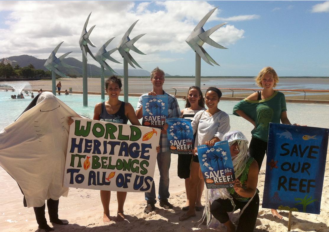 Protest to stop Queensland Resources Council dumping dredge spoil inside the Reef
Protest by Cairns and Far North Environment Centre (CAFNEC), June 2014
^http://cafnec.org.au/wp-content/uploads/2014/03/rally-promo-photo.jpg
Protest to stop Queensland Resources Council dumping dredge spoil inside the Reef
Protest by Cairns and Far North Environment Centre (CAFNEC), June 2014
^http://cafnec.org.au/wp-content/uploads/2014/03/rally-promo-photo.jpg
")


")

")


")
")

")


")


")

")

")


")

(Photo by Peter Sims, Fairfax)")


")
")
")


