Archive for the ‘Threats from Development’ Category
Saturday, August 21st, 2021
 The Gully in Katoomba – yet another vacuous draft Plan of Management by Council, 7 May 2021
A Brief Background
Back in 2004 a Plan of Management was published for The Gully in Katoomba by its government custodial owner Blue Mountains Council (Council). This followed three years of Council delegating an off-Mountains consulting firm ‘Environmental Partnership‘ (Ultimo-based) to research and draft an expensive and length report of some 105 pages.
This 2004 Plan followed a host of previous studies, reviews and reports including ‘The Bell Report’ of 1993 – its correct title being ‘Katoomba Falls Creek Valley Environmental Study‘ of some 87 pages undertaken by environmental consultants F. & J. Bell and Associates Pty Ltd. This plan in 1993 had been commissioned by local Katoomba environmental activist group ‘The Friends of Katoomba Falls Creek Valley Inc.‘ (1989-2016) thanks to a $10,000 government grant which was the cost of this very details and independent study into Katoomba Falls Creek Valley, which was Council’s official name of The Gully at the time. For more information on this study please refer to the Further Reading reference section at the end of this article.
The Gully’s evolving names
Note that the term ‘The Gully‘ was first officially applied to this creek valley in Katoomba by Council in the 2004 Plan of Management. This is the 2004 Plan -was ridiculously long title of 16 words verbatim as:
‘UPPER KEDUMBA RIVER VALLEY Plans of Management Covering the Community Lands within “The Gully” Aboriginal Place’.
Put that up your jumper! Here’s the original for reading, download and printing in the public domain:
It followed That draft document was entitled, which is an affectionate term used by former residents and their descendants from the 1950s and generation prior. Other terms for The Gully have been:
- ‘Blacks Camp‘ (a colonial disparaging term [1870s up to the 1950s] as cited in the book ‘Artificial Horizon – Imagining the Blue Mountains’, p.198, by Martin Thomas, 2004) (being the northern section)
- ‘Katoomba Falls Creek Valley‘ (being the entire 70+ hectare creek valley of riparian bushland area still not yet sold off by Council for housing)
- ‘Frank Walford Park‘ (being also the northern section)
- ‘Walford Park’ (being also the northern section without Cr Walford’s first name ‘Frank’)
- ‘McRae’s (horse) Paddock‘ (being the central section)
- ‘Selby Street Reserve‘ (being the central section’s eastern side watercourse creek gully from a spring at now Hinkler Park)
- ‘Katoomba Falls Reserve Cascades section‘ (being the same central section’s eastern side watercourse creek gully from a spring at now Hinkler Park)
- ‘Catalina Park‘ (being the northern section named by Council in the late 1950s on behalf of the Blue Mountains Sporting Car Club Ltd)
- ‘Upper Kedumba River Valley‘ (being the entire creek valley as renamed by Council in 2002)
- ‘Katoomba Falls Reserve’ (being the southern section dominated by two grass ovals named by Council)
- ‘The Gully Aboriginal Place‘ (being a lesser portion of the entire 70+ hectare creek valley of riparian bushland, since many bushblocks of what as Community Land has been sold off for housing, or else rezoned or proposed for rezoning so that Council’s coffers can be boosted by land sales for more housing)
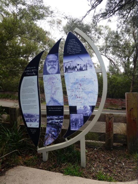
- ‘Garguree‘ is apparently a regional Gundungurra Aboriginal word meaning ‘gully’ which was purportedly provided by a local historian into Blue Mountains Aboriginal heritage Jim Smith PhD acting as a consultant to The Gully Traditional Owners (group) circa 2007.
Of note, two significant side watercourse gullies flowing into The Gully from the west are excluded from The Gully’s geographic scope by Council’s mapping.
One side watercourse flows into The Gully through a very large bushland/riparian zone side gully having a land title address of 21 Stuarts Road, Katoomba. The second to the south flows through what was clear-felled bushland/riparian zone and then bulldozed, graded and fertilized into the now defunct Katoomba Golf Course which Council had backed financially. This year the site of the old Katoomba Golf Course is being prepared by Council, external consultants again enticing two universities to develop it as believe it or not a ‘Planetary Health Leadership Centre‘ – how hypocritical on a site of ecological destruction!
Recalling the 2004 Plan of Management and its drafting, despite many efforts by locals expressing a keen desire to constructively engage with Council to provide input into this Plan, Council arrogantly shunned these requests, so very little local community consultation went into this 2004 Plan.
On page 101 under the sub-heading ‘Review of the plan of management‘ it reads as follows:
“It was the intention of the authors (Environmental Partnership) that the progress of implementation should be assessed by Council on an annual basis in terms of the performance measures described in Table 7 and updated or reviewed as appropriate. It was also outlined in the plan of management that a more comprehensive review should be made after five years to assess the effectiveness of the plan and need for review.”
This is the Table 7:
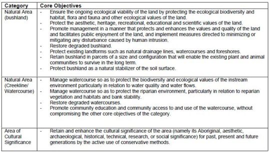
Well, neither the annual assessment of progress nor the five year review took place. None of the core objectives has been achieved by Council since 2004 (nor prior from the Bell Report of 1993) and it is now 2021.
From our experience over the past twenty years as local activists to save and protect the ecology of The Gully, Council’s ongoing neglect and abuse of The Gully has persisted and particularly Council management’s disdain for local Bushcare volunteers to altruistically request Council to commit to caring for and rehabilitating The Gully’s natural ecology after decades of harm.
It has taken until 2017 for Council to finally get around to reviewing its 2004 Plan of Management after some thirteen years, because Council was legally required to undertake a formal review of the 2004 Plan of Management – still pending in 2021…
“in accordance with the requirements of the Local Government Act 1993 (NSW) and the Crown Land Management Act 2016, and the Office of Environment and Heritage (OEH) Declared Aboriginal Place Guidelines for Development Management Plans.”
[SOURCE: ‘Public Hearing for the Proposed Recategorisation of Community Land in The Gully Aboriginal Place, July 2021, by Parkland Planners, Background Information, page 1, > https://www.habitatadvocate.com.au/wp-content/uploads/2021/08/Public-Hearing-for-Proposed-Recategorisation-of-Community-Land-in-The-Gully-Aboriginal-Place-July-2021.pdf]
The 2021 Plan has been prepared by Council’s contracted Environmental Planning Officer Soren Mortensen and Council’s Aboriginal Community Development Officer Brad Moore is vastly different to the 2004 plan. However a quick comparison of the 2004 Plan and the current 2012 draft Plan reveals that most of 2004 Plan’s 105 pages have been ignored in the 2012 draft plan. The current 2012 draft plan reads more like a cultural document borrowed from elsewhere and applied to The Gully instead of being as a place-based plan of management for a natural place as is the 2004 plan.
Our concerns about Council’s proposed “Re-categorisation” of ‘Community Land’ in The Gully
 After 20 years experience in trying to consult with Blue Mountains Council about The Gully (respecting this valley, caring for this valley and rehabilitating the valley’s neglected and abused ecology) we have learned not to trust Council management.
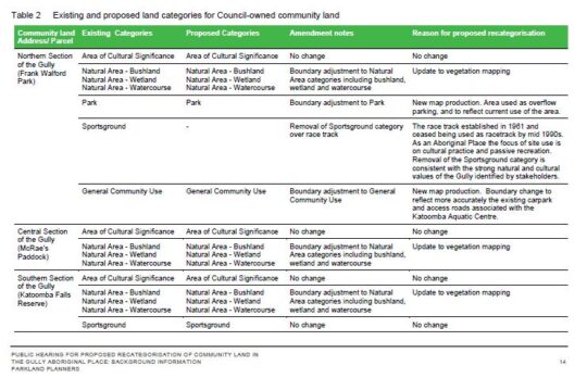
Whilst The Habitat Advocate is receptive to Council’s proposed reclassification of the current Council-owned community land specifically and only to the defunct Catalina Raceway from being a ‘Sportsground’ to being a ‘Natural Area’, this proposed reclassification is noticeably absent in the Table 2 on page 14 (copy below) of the ‘Background Information document supplied. The relevant column headed ‘Proposed Categories’ in the table is blank (“-“). Is this an oversight or intentional?
History is history, and the impost of the racetrack and motocross circuit in the northern section of The Gully back in 1957 involved Council’s forced eviction of numerous poor residents from their simple bush homes, including the violent demolition of their homes by mechanical excavators. The racetrack remnants remain since the track was ultimately shut down to vehicles permanently in 2003. We consider it is important the history of the racetrack and this traumatic story is not lost to current and future generations.
We are opposed to the remnants of the bitumen racetrack being destroyed by any excavation works, but rather the track be allowed to be significantly narrowed in width, and to be maintained to facilitate passive recreation use for following purposes:
- Recreational Walking (NOT organised running/marathon events)
- On-Leash Dog Walking (NOT off-leash and no more mass gatherings of many dogs like the RSPCA’s annual Millions Paws Walk event that invaded The Gully back in May 2004)
- Individual Cycling (NOT large groups of cyclists or organised cycling events)
- Fire Truck Emergency Access (track to a maximum width of 4 metres wide) in order to facilitate the extinguishing of a bushfire (NOT RFS bush arson/‘hazard reduction’). NB. The original racetrack width was at least 10 metres wide and has since has the natural bushland retake the invasive bitumen.
- Other Passive Uses – such as interpretation and for cultural purposes by the local Aboriginal peoples.
However, we are otherwise opposed to Council’s proposed reclassification of the Council-owned community land in The Gully because there are numerous land parcels shown in the supplied mapping on Page 16 (copy below) that indicate their removal from the current community land categorisation shown on page 15 (copy below). The fear is that this removal will result in Council’s selling the excludes land parcels for housing development and so again profiteer from The Gully as it has in the past.
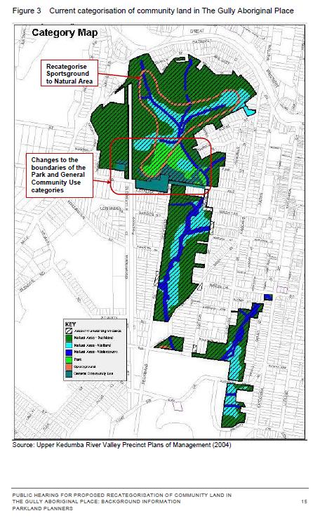
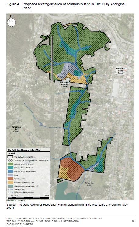
We also opposed Council’s proposed reclassification because the supplied mapping scale (approx. 1:10,000) is too small a scale ratio to read and to discern the boundary changes accurately. A more readable map scale ration would be 1:5,000 and we request that Council provide this to all registered stakeholders included in:
- Council’s Stakeholder Engagement Methodology (2018-2019)
- Council’s Public Hearing for Proposed Re-categorisation of Community Land in The Gully (2021)
Council’s supplied mapping is also obscure. Whereas the supplied map for the current categorisation (Figure 3 on page 15) is cadastral (that is, shows land parcels) and is overlayed with colour-coded categorisations; the supplied map for Council’s proposed re-categorisations is an aerial photo with the colour-coding overlay in heavy bold which makes it impossible to read accurately. The comparisons between the two map styles are also difficult to discern.
Council’s exclusion of multiple bushland sites from ‘Community Land’ status (protection)
Based upon a quick comparison of the two maps, we have concern for the following identified land parcel proposed for removal from current Council –owned Community Land included within The Gully Aboriginal Place, and we ask Council what it the justification and have explanation before this 2021 Draft Plan of Management goes before Council to be approved.
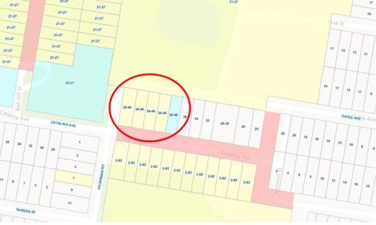
This site is the bushland block across the road from the Katoomba Sports and Aquatic Centre which covers about a hectare at address 34-46 Gates Avenue.
 This natural bushland block significantly represents one of the last natural landscapes interconnecting The Gully between the northern section and the central section. It must be naturally preserved intact as part of The Gully’s Community Land zoning (land categorisation).
Close inspection of Council’s proposed re-categorisation of Community Land map, shows that this site has been excluded from Council’s Community Land in The Gully Aboriginal Place. The logical presumption is that Council intend to rezone it ‘Operation Land’ so Council can then legally sell the hectare off to private land use developers into for or five housing lots. So the bushland gets bulldozed and Council management profiteer with a million dollar bounty.
On the above bases, we reject Council’s current (2021) proposed re-categorisation of Council-owned community land in the Gully.
Our concerns above were contributed by The Habitat Advocate to Council in its dedicated Public Hearing held via Zoom online software on Saturday 7th August 2021 as well as with a follow up email dated 12th August 2021 to Council’s delegated Environmental Planning Officer Soren Mortensen. However, no acknowledgement of that email has been received from Council.
We have sourced land title mapping of The Gully Water Catchment from Google Maps dated 2021. There are six maps that cover the water catchment extent of The Gully extending from the Cox’s watershed (Great Western Highway) in the north, down through what was Frank Walford Park and Catalina Raceway, as well as the side watercourse through Selby Reserve (from Hinker Park), and the two watercourses that flow from the west and then to Katoomba Falls Reserve and to Katoomba Falls itself.
We have compared Council’s proposed land re-categorisation map (Figure 4 above) with the land titles on these six mapped sections from Google Maps, and placed an ‘X’ on each identified the land parcel that are bushland within The Gully but which have been excluded in Council proposed recategorisation.
Not all these bushland lots are Community Land, but many are. Bushland and swampland land parcels that are categorised by Council as ‘Community Land’ are generally protected from land use development. However those bushland and swampland land parcels that are excluded from Council’s colouring in Figure 3 above, are NOT protected. Council could then easily rezone them as ‘Operation Land’ which is the next stage before selling them off for housing development. Council has a record or doing this throughout the Blue Mountains local government area over decades, including on the periphery of the Gully.
What we wish to illustrate here in these six maps is the scale to which the bushland amenity risks being destroyed for likely housing development and so alter the natural amenity of The Gully forever.
Each map below is in Adobe Acrobat (PDF). We allow for each map to be zoomed into so as to enable enlarging the map on the screen via Google Docs (free software), as well to be downloaded and printed.
Further Reading:
[1] The Gully Report No. 8, ‘Katoomba Falls Creek Valley Environmental Study‘, published in 1993, by F.J. Bell and Associates Pty Ltd, (Fred Bell), Sutherland NSW, contains 87 pages in A4 spiral softcover binding, (available internally on this website) >https://www.habitatadvocate.com.au/gully-report-no-8-the-bell-report-of-1993/
[2] The Gully Collection, by The Habitat Advocate (available internally on this website), > https://www.habitatadvocate.com.au/consultancy/the-gully-in-katoomba/the-gully-collection/
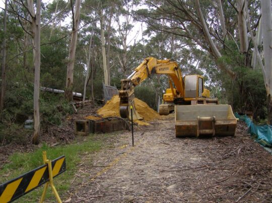 Excavator in The Gully getting stuck in with Council approval. We don’t forget. This is comparable of how Council forcibly evicted the original residents back in 1957. (Photo by Editor Sunday 17th February 2008).
Sunday, August 8th, 2021
The Gully: Blue Mountains {city} Council’s notice of an updated Plan of Management for its 2004 plan, being on public exhibition in 2021. It was only 7 years overdue.
Council’s current review of The Gully Plan of Management (2004) has been undertaken over the past five years between 2017 and 2021. Council has published four key reports in this review process currently published on Council’s webpage: https://yoursay.bmcc.nsw.gov.au/gully-plan
These four key reports are as follows:
Report A: Upper Kedumba River Valley – Plans of Management (revised edition 2004)
Report B: The Gully – Stakeholder Engagement Report [2018-2019] (June 2019)
Report C: Public Hearing for Proposed Recategorisation of Community Land in The Gully Aboriginal Place (July 2021)
Report D: The Gully Aboriginal Place Draft Plan of Management (7th May 2021)
We anticipate that Council’s above outsourced ‘yoursay…’ webpage will likely be publicly available only for the duration of Council’s current review process, then it will be deleted by Council soon after Council’s review process has concluded. So in the local community interest, since these reports and their research have been both publicly funded and concern a public place ‘The Gully’ in Katoomba, we herein provide an enduring online record for the interested public.
Each of these reports are provided below as links to the same reports stored internally on our website in Adobe Acrobat format and available to the public to download and to print…
A: Upper Kedumba River Valley – Plans of Management (revised edition 2004)
>Upper Kedumba River Plans of Management – revised edition in 2004
B: The Gully – Stakeholder Engagement Report ‘Talking with the Community’ (2018-2019) (Report dated June 2019)
>The Gully – Stakeholder Engagement Report (June 2019)
C: Public Hearing for Proposed Recategorisation of (Council-owned) Community Land in The Gully Aboriginal Place (Report dated July 2021)
>Public Hearing for Proposed Recategorisation of Community Land in The Gully Aboriginal Place (July 2021)
D: The Gully Aboriginal Place Draft Plan of Management (Report dated 7th May 2021)
Preparation of this draft document was partly funded by Blue Mountains Council and supplemented by the NSW Government out of its ‘NSW Heritage Grants – Aboriginal Heritage Projects’ in 2017-2018 from NSW taxpayer funding, that is, by the wider general community.
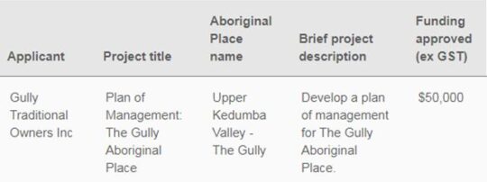 SOURCE: ^https://www.heritage.nsw.gov.au/grants/grants-recipients/2017-18-heritage-grants/ SOURCE: ^https://www.heritage.nsw.gov.au/grants/grants-recipients/2017-18-heritage-grants/
This draft document comprises some 140 pages with an Adobe Acrobat file size of 22 MB. So for community access and download convenience, we have divided the original document into smaller sections in order via hyperlinks internally within our website to sections in Adobe Acrobat format, each of which is downloadable to the general public in perpetuity. We consider this is in the public interest since the community lands concerned within The Gully are publicly owned through Council and the draft plan has also been public funded.
- >Contents and Foreword
- >Executive Summary
- >Introduction
- >The Gully is Country
- >A Declared Aboriginal Place
- >Working with Legislation
- >Speaking with the Community
- >Caring for Country
- >Implementation
- >Monitoring and Review
- >References
Background
‘Blue Mountains Council* ‘has prepared a Draft Plan of Management (PoM) for The Gully Aboriginal Place in accordance with the requirements of the Local Government Act 1993 and the Crown Land Management Act 2016, and Office of Environment and Heritage (OEH) Declared Aboriginal Places Guidelines for Developing Management Plans.
The Draft Plan of Management updates the 2004 Plans of Management for Upper Kedumba River Valley, covering the Blue Mountains City Council managed community lands within The Gully including Frank Walford Park 2003, Katoomba Falls Reserve McRae¡¦s Paddock Section and Katoomba Falls Reserve Cascades Section 2003. The draft 2021 Plan of Management for The Gully includes the addition of three parcels of Crown land, covering all public land within The Gully Aboriginal Place.
Council has placed The Gully Aboriginal Place Draft Plan of Management on public exhibition for comment until Monday 26 July 2021. The Draft Plan of Management is available to view online at the Blue Mountains City Council website https://yoursay.bmcc.nsw.gov.au/gully-plan
The existing community land categories (as defined under Section 36 of the Local Government Act 1993) over Council managed land are being amended to:
-
- Remove the Sportsground category over the race track in Frank Walford Park to be replaced by the Natural Area category;
- Reflect changes in boundaries between the Park and General Community Use categories in Frank Walford Park;
- Reflect an update to vegetation mapping within the Natural Area category in Frank Walford Park, McRae’s Paddock and Katoomba Falls Reserve.
The proposed recategorisation of these parts of The Gully Aboriginal Place is set out in the Draft Plan of Management and in Section 3 of this document.’
NOTE 2: We do not expect that Council’s above hyperlink will last for very long, hence why we have downloaded Council’s’ publicly funded documents to our website in the public interest.
* NOTE 2: The Habitat Advocate disagrees with Council’s propaganda to incorporate the word ‘City’ into its organisational title.
 Katoomba Falls Creek (in 2002 Council unilaterally renamed the creek ‘Upper Kedumba River’)
Community Consultation Restricted (yet again)
Council’s chosen community consultation process continues to be restricted on a one-way basis. Members of the community only have the choice of the following one-way communication means:
A. Internet by mandatory registration and completing an online submission form at https://yoursay.bmcc.nsw.gov.au/gully-plan
B. In writing by: email: council@bmcc.nsw.gov.au Attention: Andrew Johnson/Soren Mortensen; and to Environmental Planning Officer smortensen@bmcc.nsw.gov.au
C. In writing by post to Blue Mountains City Council, Locked Bag 1005, KATOOMBA NSW 2780 Attention: Andrew Johnson/Soren Mortensen
No public forum either face-to face or online was offered by Council to the general community. The only public forum offered by Council to the general community was a Public Hearing held on Saturday 8th August 2021 (1pm-3pm). This hearing took place via Zoom meeting software in compliance with the NSW Government’s public health order social lockdown in response to the Coronavirus pandemic.
However, this ‘public hearing’ did not address this Draft Plan of Management, but was instead strictly limited to Council’s proposed re-categorisation of various land parcels throughout The Gully gazetted as ‘Council-owned Community Land‘.
The only material provided by Council on this specific sub-topic was a table and two tiny maps. This was not made clear in advance to the community participants (which numbered just 32).
The material relevant to the public hearing was actually not part of the Draft Plan of Management, but in a quite separate document entitled ‘Public Hearing For Proposed Recategorisation of Community Land in The Gully Aborigional Pace – Background Information‘, dated July 2021. This hearing was only offered by Council only because legally Council had to comply with Section 40A of the Local Government Act 1993, which as at 10th June 2021 reads as follows:
‘LOCAL GOVERNMENT ACT 1993 – SECT 40A: Public hearing in relation to proposed plans of management
(1) The council must hold a public hearing in respect of a proposed plan of management (including a plan of management that amends another plan of management) if the proposed plan would have the effect of categorising, or altering the categorisation of, community land under section 36(4).
(2) However, a public hearing is not required if the proposed plan would merely have the effect of altering the categorisation of the land under section 36(5).
(3) A council must hold a further public hearing in respect of the proposed plan of management if–
(a) the council decides to amend the proposed plan after a public hearing has been held in accordance with this section, and
(b) the amendment of the plan would have the effect of altering the categorisation of community land under section 36(4) from the categorisation of that land in the proposed plan that was considered at the previous public hearing.’

Planning Review Timeline:
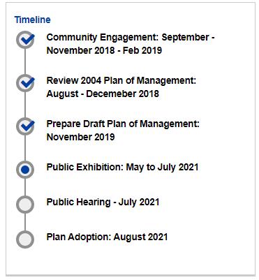
Wednesday, July 26th, 2017
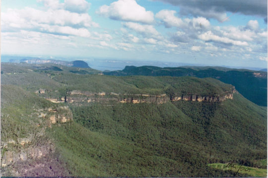 Elphinstone Plateau from the north Elphinstone Plateau from the north
© c.1991 Wyn Jones (biologist, NPWS)
Elphinstone Plateau is magnificently wild, forming an outstanding undeveloped peninsula-plateau jutting out into the Megalong. It has long been a favourite wilderness destination for bushwalkers and rock climbers alike.
This predominantly natural and undisturbed plateau is mistakenly also referred to as ‘radiata plateau‘ due to a small invasive private pine plantation from the 1970s covering less that 5% of the plateau along an access track . The plantation failed and the owner went broke.
Yet little known Elphinstone Plateau remains special home to rare and threatened regionally native species, culturally significant to local Aboriginal peoples and a magnet for the local outdoor community.
Sitting on the southern escarpment, Elphinstone Plateau, just west of Katoomba, towers high above rolling valleys has outstanding topography. It remains the last remaining undeveloped peninsula-plateau in the upper Blue Mountains. The Plateau has significant biodiversity, including vegetation communities such Blue Mountain Swamps, Eucalyptus Oreades Open Forest and Blue Mountains Heath. It is also home to many endangered species including the Flame Robin, Glossy Black Cockatoo, Gang-Gang Cockatoo and the Varied Sittella as well as the Tiger Quoll, frequently sighted by locals. Threatened plants include one of only ten places on the planet where the Dwarf (Blue) Mountain Pine (Pherosphaera fitzgeraldii) is endemic on the planet to the immediate upper Central Blue Mountains with its distribution fragmented to a few south-facing hanging swamp cliff faces on the Blue Mountains western escarpment at Elphinstone above Nellies Glen and nearby around Wentworth Falls above the Jamison Valley.
The IUCN reports that this taxon is endangered. It faces a very high risk of extinction in the wild in the near future due to a small population size and severe population fragmentation, with no sub-population estimated to contain more than 250 mature individuals.
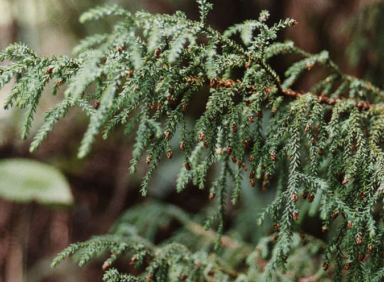 The Dwarf Mountain Pine endemic on the planet to wet rocks within the spray of waterfalls of Elphinstone and Wentworth Falls The Dwarf Mountain Pine endemic on the planet to wet rocks within the spray of waterfalls of Elphinstone and Wentworth Falls
(Harden 1990, Hill 1998)
Steven, one of our local conservationists says that this wild plateau has significant biodiversity – Blue Mountain Swamps, rare Eucalyptus oreades Open Forest and many endangered species including the Flame Robin, Glossy Black Cockatoo, Gang-Gang Cockatoo, and the almost unknown Tiger Quoll.
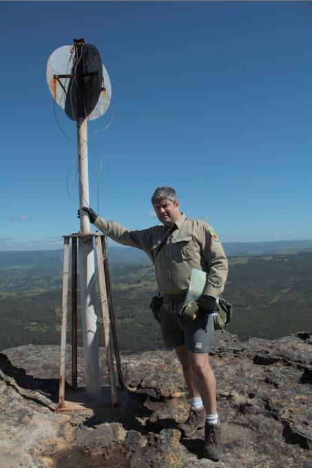 One of our local conservationists at Megalong Head on Elphinstone Plateau One of our local conservationists at Megalong Head on Elphinstone Plateau
Steven says that the plateau and its immediate surrounds provide are the only locality on the planet to naturally support the critically endangered Dwarf Mountain Pine and the little-known yellow flowering shrub Elphinstone Boronia (Leionema lachnaeoides). Both are threatened with extinction and their survival depends on the area remaining undisturbed.
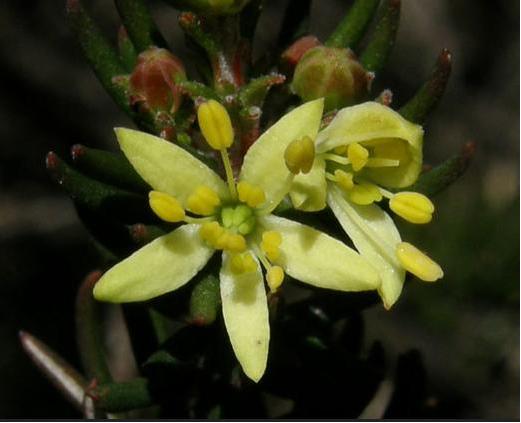 Threatened species Elphinstone Boronia (Leionema lachnaeoides) Threatened species Elphinstone Boronia (Leionema lachnaeoides)
Endemic to Elphinstone Plateau (that means it grows natively nowhere else on the planet)
© Waratah Software
Survival depends on the area remaining undisturbed.
Steven says local resident Glenn Humphreys has been involved with trying to protect and save Mount Elphinstone from housing development on and off for more than 25 years, successfully halting all sorts of elaborate development proposals.
But now this wild and unique haven is at risk. An integrated part of the Blue Mountains western escarpment has come under threat of land use development again – Mount Elphinstone (also mistakenly called Radiata Plateau) situated a few kilometres west of Katoomba. Apart from a small area of Crown Land the majority of the Plateau is privately owned by a group that have repeatedly lodged development applications since the 1990s.
Elphinstone Namesake
Mount Elphinstone, being the highest rise on the plateau is believed named after Major General Sir Howard Craufurd Elphinstone, VC, KCB, CMG (1829 – 1890) who was a British Army officer and a recipient of the Victoria Cross.
Born in Livonia (now Estonia), Elphinstone joined the British Corps of Royal Engineers as a gentleman cadet at the Royal Military Academy, Woolwich and was commissioned as a second lieutenant in December 1847. With the outbreak of the Crimean War, Elphinstone was posted to the Crimea.
On 18 June 1855, he was 25 years old, and a lieutenant in the Royal Engineers, during the Siege of Sebastopol when the following deed took place for which he was awarded the Victoria Cross.VC.
His citation read:
“For fearless conduct, in having, on the night after the unsuccessful attack on the Redan, volunteered to command a party of volunteers, who proceeded to search for and bring back the scaling ladders left behind after the repulse; and while successfully performing this task, of rescuing trophies from the Russians, Captain Elphinstone conducted a persevering search, close to the enemy, for wounded men, twenty of whom he rescued and brought back to the Trenches.”
With the end of the war he was decorated by both Napoleon III, Emperor of France being appointed as a Knight of the Legion of Honour.
Private Development Threats to the Plateau
A proposed private development threatens its future. Currently, two of three development applications recently lodged have been refused, leaving one approved for two dwellings. They pose an inappropriate development wedge to future residential exploitation of this still wild plateau.
Now is the time to prevent any building and move the Plateau in public ownership for protection. This could be the public’s last chance to secure the future of this stunning area and have Elphinstone Plateau become part of the National Park estate.
Blue Mountains residents, the local outdoor community, and the Blue Mountains Conservation Society are all firmly committed to seeking protection for the Plateau. We were delighted with all the community support our campaign received at Winter Magic – with lots of cheers from the crowd during the parade and most importantly all the letters sent off to the Minister for the Environment.
We are seeking to have Elphinstone Plateau purchased by the New South Wales or Australian Commonwealth governments and be incorporated into the Blue Mountains World Heritage Area.
But the battle is not yet won. The local Blue Mountains Conservation Society is championing an environmental campaign to oppose the land use development and to have the plateau incorporated into the adjacent Blue Mountains World Heritage Area.
The Society is inviting locals and those passionate about protecting this special place, to join in a rally on Sunday 30th July at 1.30pm at Cahill’s Lookout, Cliff Drive, Katoomba.
Further Reading:
.
[1] Leave Radiata Plateau Wild Campaign, ^ http://www.bluemountains.org.au/leaveradiataplateauwild/
.
[2] Elphinstone (Radiata) Plateau – Bushwalk: Bottleneck Pass and The Devils Hole (29 June 2016) by Dave Noble (NPWS), ^ http://www.david-noble.net/blog/?p=11300
.
[3] Dwarf Mountain Pine (Pherosphaera fitzgeraldi), The Gymnosperm Database, ^ http://www.conifers.org/po/Pherosphaera_fitzgeraldi.php
.
[4] Major General Sir Howard Craufurd Elphinstone, ^ https://en.wikipedia.org/wiki/Howard_Craufurd_Elphinstone
.
Monday, November 3rd, 2014
 ATLAS of Katoomba
[ © Photo by Editor 20140907, Katoomba, Blue Mountains World Heritage Area] ATLAS of Katoomba
[ © Photo by Editor 20140907, Katoomba, Blue Mountains World Heritage Area]
.
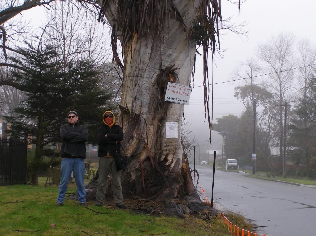
At an informal community meeting at ATLAS (a 200+ year old endemic Blue Mountains Ash) today, it has been made public that Blue Mountains Council’s tree officer had been inappropriately coerced by a councillor in 2010 to have this magnificent iconic tree conveniently killed. According to the officer it is because of a (very) close association with a property developer of the adjoining site.
Fortunately the tree officer, out of respect for this heritage tree and out of respect for the rule of law and for due process, personally stood up to the councillor’s intimidation and so appropriately arranged for an independent arborist to evaluate the viable health of this tree.
That independent arborist reported that the tree was healthy and ought to be retained, and so it has.
All credit to Council’s Public Tree Officer for resolutely following due process. The developer has a track record of ignoring Blue Mountains Councils development consent conditions relating to this tree. DA consent conditions 61, 62, 63, and 68 have all been ignored or breached.
Despite Council’s requirement for Tree Protection Measures and a Tree Protection Plan, neither were supplied, yet the industrial development was allowed to proceed.
The developer has illegally lopped a healthy branch from the tree.
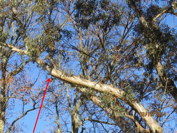 Main branch illegally lopped by the developer’s contractor without Council permission
[ © Photo by Angophora Consulting Arborist, 201410-03, Katoomba, Blue Mountains World Heritage Area] Main branch illegally lopped by the developer’s contractor without Council permission
[ © Photo by Angophora Consulting Arborist, 201410-03, Katoomba, Blue Mountains World Heritage Area]
.
The developer furnished no Tree Protection Measures, Tree Protection Plan or Tree Protection Zone. In the mind of the developer, the tree is situated on Council land after all. He knew as such and was likely told that his environmental bond was a farce.
He is correct. So this is why a string of Council bureaucrats have gone running for cover. .
Thursday, October 16th, 2014
 Elphinstone Plateau Elphinstone Plateau
(from Mount Mark cliff edge looking SW)
Blue Mountains World Heritage Area
[Photo Source: © Wyn Jones, circa 1991]
.
There exists a vast plateau unspoilt from the valley floor and it lies just west of Katoomba in the Blue Mountains.
It is Elphinstone Plateau, known mainly to locals and to informed bushwalkers. It’s deep gorges provide critical habitat to one of the world’s most endangered plants, Microstrobos fitzgeraldii, and to its integral waterfall spray dependent ecological community.
Elphinstone Plateau lies interconnected with the Cox’s Watershed traversing the Blue Mountains World Heritage Area, connected to National Parks owned land, to Narrow Neck and to the Jamison Valley. The photo above shows how country is interconnected in the Blue Mountains and that Elphinstone Plateau remains one of the last surviving wild places of the Central Blue Mountains area. We value it.
Elphinstone Plateau is an integral continuum of the Blue Mountains Great Southern Escarpment. Elphinstone Plateau’s uniqueness and its dependent habitat and wild values deem that it should be integrated into the Blue Mountains National Park and the Greater Blue Mountains World Heritage Area.
Elphinstone Plateau’s history contains stories, many sad and some a curse, and more recently of local community battles fought for years late into the night driven by a committed local few.
 Exploring Elphinstone Plateau
[Photo © The Habitat Advocate, no reproduction permitted] Exploring Elphinstone Plateau
[Photo © The Habitat Advocate, no reproduction permitted]
The website is about to embark on a protracted conservation campaign to “Save Elphinstone Plateau” from Developer Wars – Book 3. The Habitat Advocate has its origins within walking distance of Elphinstone Plateau. We have explored it, but we know little of its ecology, its history, its Aboriginal heritage, its recurring struggles against selfish developer exploitation. So we are about to research all this and share our research journey on this website in the months to follow.
In doing so, we shall be shining a light on the stories of battles that have come before, back to the 1980s. This promises to stir skeletons from closets and to reveal facts that some would prefer were forgotten. For those interested in documentaries and reading history, our series of articles pursuing this conservation campaign will be an epic ride connecting the present to the past.
So after months of online hibernation, The Habitat Advocate is back in conservation action, awoken by a conservation warrior, asking us for support.
Elphinstone Plateau is where this website and logo were conceived.
Friday, October 10th, 2014
 Katoomba residents Maureen and Peter Toy with Glenn Humphreys (right) marvel at Katoomba’s largest native tree
[Photo © Friends of Atlas, 20140907, click image to enlarge] Katoomba residents Maureen and Peter Toy with Glenn Humphreys (right) marvel at Katoomba’s largest native tree
[Photo © Friends of Atlas, 20140907, click image to enlarge]
.
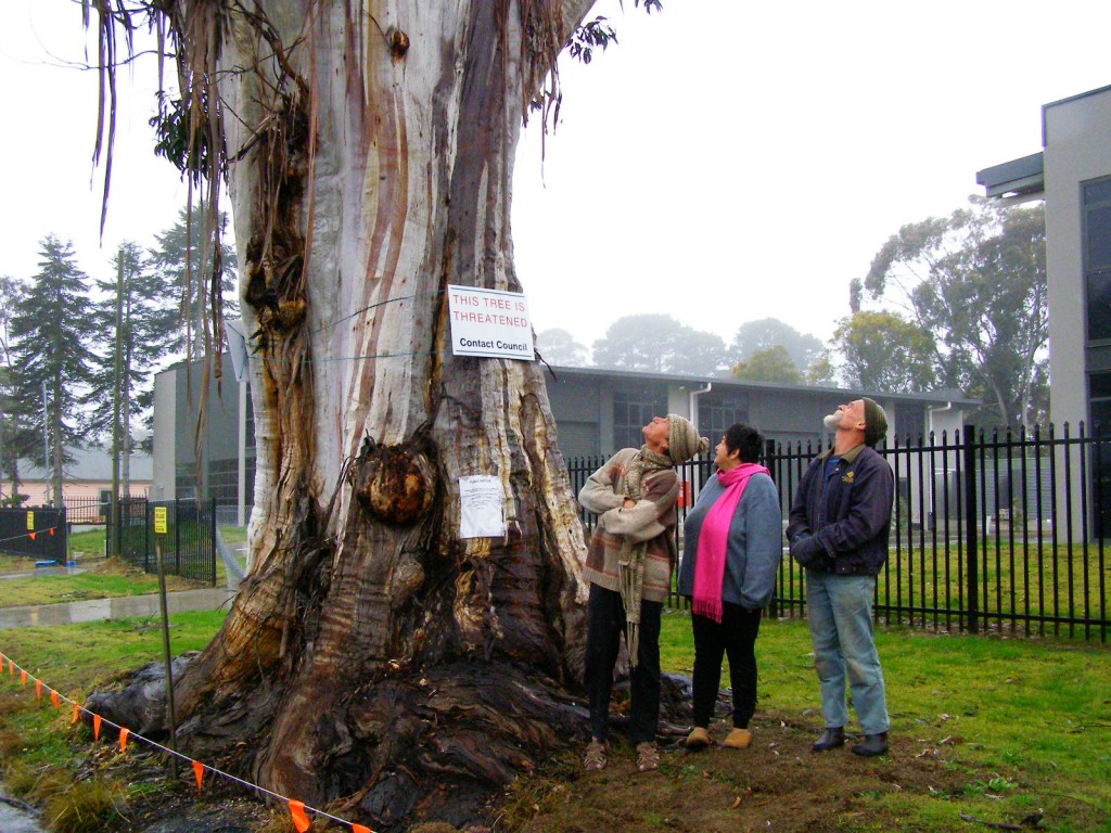
Residents of the Blue Mountains, Maureen and Peter Toy, were shocked to learn last month about an arbitrary claim for this magnificent tree (pictured) to be killed for what they consider can be no rational reason.
According to advice that the Toys received from local conservation consultancy The Habitat Advocate, this large Blue Mountains Ash (Eucalyptus oreades) is a native tree only found in the Upper Blue Mountains. This particular specimen probably dates to 19th Century colonial settlement in Australia.
Maureen says “It is a beautiful and rare specimen and Blue Mountains folk are fortunate that we have such a significant tree still growing right by Megalong Street in now an increasingly industrialised part of Katoomba.”
Over the many decades, this great tree has withstood fierce windstorms, bushfires, road-widening right up to its trunk and industrial development all around it. With a canopy about 40 metres high and a trunk girth of over 5 metres, the tree has become a recognised icon and reference point in the area. It is home to a flock of sulphur-crested cockatoos.
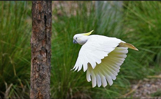 Sulphur-crested Cockatoo (Cacatua galerita)
These character parrots may be of ‘Least Concern’ to IUCN, but to the clan of cockies habitating Atlas, this is their home.
[Source: Zoos Victoria, ^http://www.zoo.org.au/healesville/animals/sulphur-crested-cockatoo] Sulphur-crested Cockatoo (Cacatua galerita)
These character parrots may be of ‘Least Concern’ to IUCN, but to the clan of cockies habitating Atlas, this is their home.
[Source: Zoos Victoria, ^http://www.zoo.org.au/healesville/animals/sulphur-crested-cockatoo]
.
Maureen affectionately calls the tree, ‘Atlas’, after the Greek God, for its towering size and for being so enduring. There is no other quite like it perhaps throughout the world renown Blue Mountains World Heritage Area.
Peter can’t understand why the tree is not on Council’s Significant Tree Register or why anyone would want to harm it. The tree is on community verge land and for the past few years there has been an industrial development constructed behind it. Peter and Maureen are vehemently opposed to any further harm being inflicted upon the tree and they have lodged a protest with council.
Several others in the local community have sided with the Toys and together have formed a local group ‘Friends of Atlas’ determined to protect the tree. Peter is looking to start a petition to garner local community recognition and support to protect the tree. He says “it is early days but he is ready for a sustained fight.”
A spokesperson from Blue Mountains (city?) Council has confirmed that the tree is situated on ‘Community Land‘ on the verdant verge strip between the street and the new industrial development at number 59 Megalong Street. The tree and its canopy and root system is not on private land, but on Community Land. Council has a duty as the community-delegated custodian of all community lands throughout the Blue Mountains Local Government Area. Council does not ‘own’ the tree per se, rather Council acts as the responsible custodian of this significant tree.
Council has stipulated in its development consent conditions for the adjoining industrial development application since 2010 that the tree must not be harmed by the current development activity.
But Peter disagrees. He says “guttering has been dug right into the tree roots system and just a month ago the developer had a bobcat grade the topsoil and roots around the tree for an entire day!.”
Council’s spokesperson says that council has not received any request for the tree to be destroyed.
A battle to save the tree is set to ensue.
.
Further Reading:
.
[1] Campaign Facebook Page: ^https://www.facebook.com/friendsofatlas
.
[2] Greater Blue Mountains World Heritage Area, ^http://whc.unesco.org/en/list/917
.
[3] Blue Mountains (city?) Council’s promotional tourism hypocrisy (or ‘greenwashing‘): ”
<<The Greater Blue Mountains World Heritage Area only exists today because of a 70-year campaign by conservationists to achieve a chain of reserves across the region. This culminated in the year 2000 with the acceptance of 10,000 square kilometres of wild bushland onto the World Heritage list – the ‘best of the best’.>>
Source: Blue Mountains (city?) Council, ^http://www.greaterbluemountainsdrive.com.au/
.
…70 years hence, this is the same reason why conservationists ‘Friends of Atlas’ have started a campaign. Atlas is the “best of the best”.
.
Wednesday, November 27th, 2013
 A rare and perhaps 150 year old and healthy endemic Eucalpytus Oreades tree
Land buyer: “Hey Asplundh, it’s in the way of where I want to build a house to sell for profit.” A rare and perhaps 150 year old and healthy endemic Eucalpytus Oreades tree
Land buyer: “Hey Asplundh, it’s in the way of where I want to build a house to sell for profit.”
.
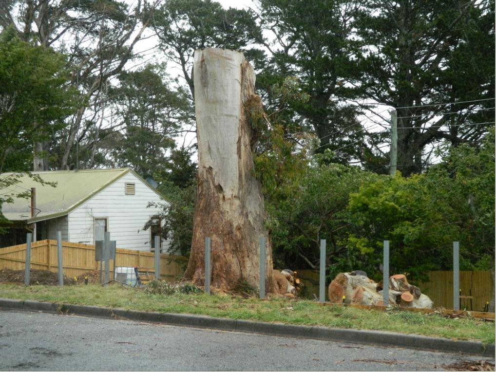
Our Investigative Journalist: “I think the E.Oreades was chopped down today (20131125) , as I heard a chainsaw coming from Loftus St.”
When 17 year olds were cut down in the prime of their life during The Great War for no reason or for someone else’s evil ends, all involved governments just sent in more to top up the slaughter with the stroke of a polly pen.
When it comes to preservating ecological life worth living, Blue Mountains Council in 2013 belongs to that same callous mindset. They continue to proclaim being a City within a World Heritage Area.
God knows why.
.
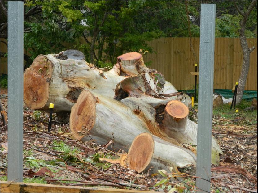 A healthy specimen of an Oreades with no signs of disease or rot.
We consider that what took place in Loftus Street Katoomba, Blue Mountains on Monday 25th November 2013, was an act of callous ecological murder
A healthy specimen of an Oreades with no signs of disease or rot.
We consider that what took place in Loftus Street Katoomba, Blue Mountains on Monday 25th November 2013, was an act of callous ecological murder
by Asplundh for one property developer’s personal greed.
.
“All that is necessary for the triumph of evil is that good men do nothing.”
.
~ Edmund Burke PC (b.1729) an Irish statesman, author, orator, political theorist and philosopher.
.
Thursday, September 26th, 2013
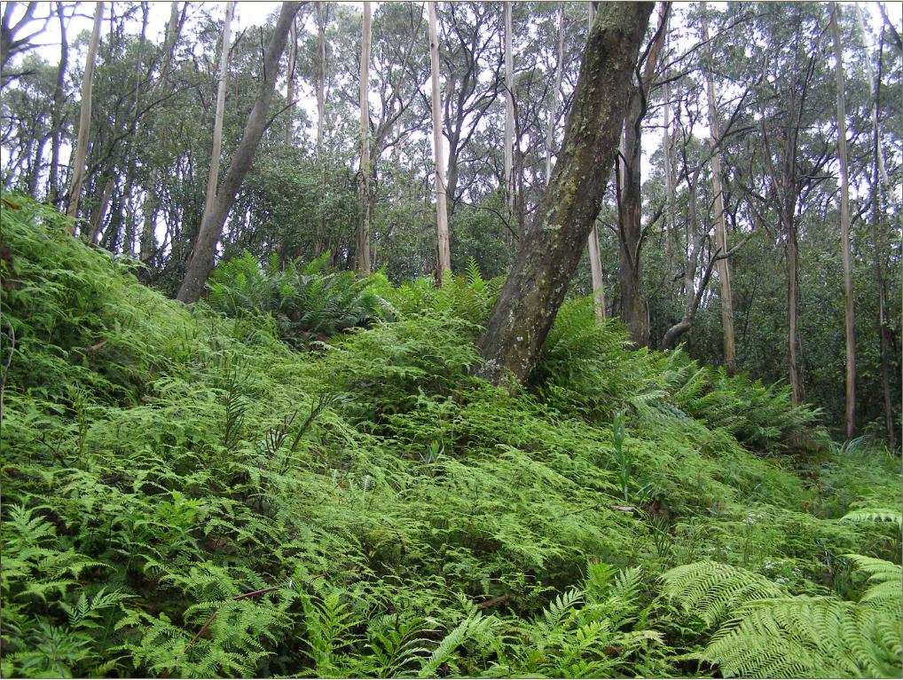 This is a Blue Mountains Swamp
It is a surviving remnant of Blue Mountains Swamps in the Sydney Basin Bioregion ecological community, which in 2005 were listed as Endangered by the Commonweath Threatened Species Scientific Committee.
[Photo by Editor 20120128, photo © under ^Creative Commons]
Click image to enlarge This is a Blue Mountains Swamp
It is a surviving remnant of Blue Mountains Swamps in the Sydney Basin Bioregion ecological community, which in 2005 were listed as Endangered by the Commonweath Threatened Species Scientific Committee.
[Photo by Editor 20120128, photo © under ^Creative Commons]
Click image to enlarge
.
Blue Mountains Swamps?
.
Blue Mountains Swamps are globally restricted to the Central (and upper) Blue Mountains and to Newnes Plateau at altitudes between 600 m to 1200 m AMSL. They exist on peat soils above a sandstone substrate geomorphology. The soil tends to be water logged due to the presence of constant groundwater seeping over the impermeable claystone layers in the sandstone which impedes their drainage, however some swamps can be constantly flooded or else ephemeral, varying with seasonal rainfall patterns and more long term with El Niño/La Niña climatic phases.
Blue Mountains Swamps are typically situated at the headwaters of watercourses below ridges, but can also be hanging swamps on steep ridges, or valley bottom swamps. The structure and species composition of Blue Mountains Swamps varies with localised geology, topographic location, depth of the water table, extent and duration of water logging, drainage gradients, sedimentation and soil type.
Blue Mountains Swamp vegetation structure can range from being open or closed variants of sedgeland, rushland, heath, tussock grassland, tussock grassland, tall grassland, scrub and tall shrubland. The vegetation is typically under 3 metres in height, although taller shrubs may be present. Emergent tree species favouring wet root systems can occur on the swamp margins, and the vegetation here tends to be closed woodland in their undisturbed natural state.
Both the structure and species composition of swamp vegetation vary from site to site, and the individual species and structural types shown below do not all occur at every site. Within a single swamp area a complex mosaic of vegetation types (structure and species composition) may be present.
The structure of Temperate Highland Peat Swamps on Sandstone vegetation includes sedgeland, closed sedgeland, open-rushland, open-heath, closed-heath, tussock grassland, closed-tussock grassland, tall closed-grassland, open-scrub and tall shrubland. The vegetation is usually less than 3 m in height, although taller shrubs may be present. Emergent trees may occur on swamp margins, and the vegetation here tends to open woodland.
Typical vegetation is characterised by the presence of sedges, graminoids (grass-like plants) and forbs (herbaceous non-grass or grass-like plants) with or without shrubs. They are endemic to the upper Blue Mountains, comprising numerous small patches which aggregate to being about 3,000 heactares in total area. They occur naturally nowhere else on the planet.
Blue Mountains Swamps are scientifically included as a class within the nationally recognised Temperate Highland Peat Swamps on Sandstone ecological community. On 29th April 2005, Temperate Highland Peat Swamps on Sandstone was included in the list of nationally threatened ecological communities under section 181 of Australia’s Environment Protection and Biodiversity Conservation Act 1999. [Source: ^http://www.comlaw.gov.au/Details/F2005L01134]. This was mainly due to Threatened Species Scientific Committee recognising its limited distribution and vulnerability to ongoing threats.
It followed a ten year campaign by Blue Mountains environmentalists..
.
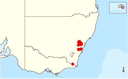 Global distribution map of Temperate Highland Peat Swamps on Sandstone ecological community.
[Source: Temperate Highland Peat Swamps on Sandstone, Biodiversity, Species Profile and Threats Database, Department of the Environment, Australian Government, ^http://www.environment.gov.au/cgi-bin/sprat/public/publicshowcommunity.pl?id=32#status] Global distribution map of Temperate Highland Peat Swamps on Sandstone ecological community.
[Source: Temperate Highland Peat Swamps on Sandstone, Biodiversity, Species Profile and Threats Database, Department of the Environment, Australian Government, ^http://www.environment.gov.au/cgi-bin/sprat/public/publicshowcommunity.pl?id=32#status]
.
Twynam Swamp
.
Twynam Swamp is essentially an upland Blue Mountains Sedge Swamp dominated by coral fern (Gleichenia dicarpa).
It is situated on a hillside at the headwaters of Katoomba Creek in the heart of the distribution area for Temperate Highland Peat Swamps on Sandstone. The swamp here is predominantly a sedge swamp and is permanently water logged, probably due to the localised presence of natural groundwater springs.
This particular upland swamp area features a diverse ecological community including the following indicator swamp flora species:
.
-
Coral Fern (Gleichenia dicarpa),
-
King Fern (Todea barbara)
-
Tasman Flax-lily (Dianella tasmanica)
-
Soft Twig Rush (Baumea rubiginosa)
-
Fork-leaved sundew (Drosera binata)
-
Red-fruit Saw Sedge (Gahnia sieberiana)
-
Alpine Heath (Epacris paludosa)
-
Spreading Rope Rush (Empodisma minus)
-
Mat Rush (Lomandra longifolia)
-
Peat Moss (Sphagnum cristatum) in the ground layer
.
and a range of Hakea and Grevillea shrub species.
.
Characteristic of this upper Blue Mountains ridgeline landscape, above this swamp margin stands emerging Eucalyptus oreades, endemically rare in their own right.
Twynam Swamp is but one of the Blue Mountains Swamps localised fragile ecosystems coming under increased pressure mainly by deforestation for housing development and by frequent bushfires especailly from broadscale hazard reduction regimes. Both practices are not only facilitated by government, but sanctioned and enshrined in legislation, despite being scientifically recognised as key threatened processes.
.
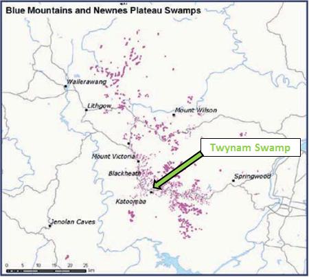 Larger scale distribution map of Blue Mountains and Newnes Plateau Swamps
[Source: ‘Nationally threatened species and ecological communities’, Department of the Environment, Australian Government,
^http://www.environment.gov.au/biodiversity/threatened/publications/pubs/temperate-highland-peat-swamps.pdf] Larger scale distribution map of Blue Mountains and Newnes Plateau Swamps
[Source: ‘Nationally threatened species and ecological communities’, Department of the Environment, Australian Government,
^http://www.environment.gov.au/biodiversity/threatened/publications/pubs/temperate-highland-peat-swamps.pdf]
.
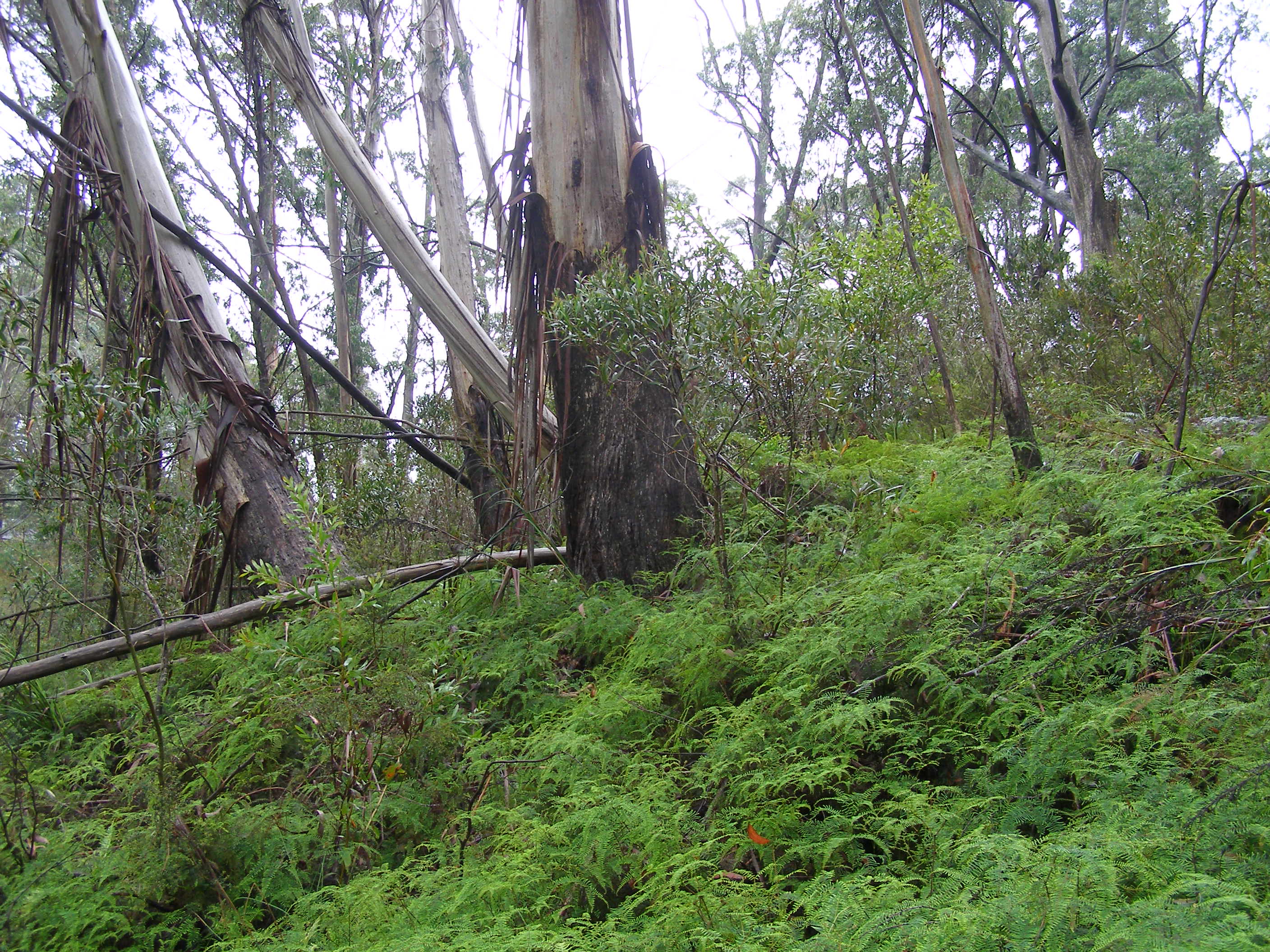 This Blue Mountains Swamp also contains a rare significant stand of Eucalyptus oreades (Blue Mountains Ash) around its periphery, which in itself holds rare ecological value.
[Photo by Editor 20120128, photo © under ^Creative Commons]
Click image to enlarge This Blue Mountains Swamp also contains a rare significant stand of Eucalyptus oreades (Blue Mountains Ash) around its periphery, which in itself holds rare ecological value.
[Photo by Editor 20120128, photo © under ^Creative Commons]
Click image to enlarge
.
But try telling this to the local Blue Mountains Council. Council has just approved the bulldozing through and above this endangered and protected swamp for housing development.
Council’s zoning under its own Local Environment Plan of 1991 actually recognises this particular swamp as being environmentally protected. The swamp covers much of the Katoomba Creek headwaters site that has just been approved for housing development at the end of Twynam Street. It practically adjoins a restricted Sydney Water Catchment area on the ridgetop.
This site is a swamp. It has no connected water, power, gas or telephone. It has no stormwater connection. It is a swamp.
Not surprisingly, the developer’s Flora and Fauna Assessment has concluded that the bulldozing of the swamp will “unlikely.. (cause) any significant impact on any endangered ecological community, population or any threatened species and as such a Species Impact Statement.” [Source: Anderson Environmental Consultants, May 2012, for 121 Twynam Street, p. 13]
So Blue Mountains Council’s Senior Environmental Health and Building Surveyor, Daniel Roberts, approved construction two weeks ago (12th September 2013) for a two storey dwelling and driveway to carve through this Blue Mountains Swamp. The consent conditions for this development application (X/673/2012) read as if the site was just an urban block of land in downtown Sydney; nothing special.
Rules for some?
Still council’s wholesome vision advocates “respecting our heritage and safeguarding our fragile environment” – a clear disconnect between propaganda and practice.
.
 Blue Mountains Swampcare at Kittyhawke Swamp, Wentworth Falls.
Similar swamp characteristics, just more convenient location for Council and Parks Service to jointly show they care.
[Source: Blue Mountains Council’s Upland Swamp Rehabilitation Programme (2007) enticing community volunteers.] Blue Mountains Swampcare at Kittyhawke Swamp, Wentworth Falls.
Similar swamp characteristics, just more convenient location for Council and Parks Service to jointly show they care.
[Source: Blue Mountains Council’s Upland Swamp Rehabilitation Programme (2007) enticing community volunteers.]
.
Ed: To Blue Mountains Council development staff, ‘Temperate Highland Peat Swamps on Sandstone’ national legislation is a discretionary matter depending upon where the swamp happens to be situated.
.
Blue Mountains Council is content to be hypocritical about its stance on protecting Blue Mountains Swamps under its Swampcare Programme, while at the same time its development planning staff authorise destruction of these swamps. It is in flagrant breach of national legislation.
Fortunately, there remain many in the local Blue Mountains community who place high value and have due respect for Blue Mountains Swamps and their need for consistent protection under the national legislation, irrespective of where the swamps happen to be situated. Next door resident, Francis Scarano, has repeatedly objected to the Blue Mountains Council about this development’s certain destructive impact upon the swamp:
.
“The swamp out the front will die along with the E. Oreades as they are not able to cope with excavation for the drive way across roots and concrete next to them and the swamp cannot cope with cut ground water supplies.
What happens when you build above a swamp? You kill a swamp even if you do not build on it. Development above is more than enough to do the job. Winding roads around Eucalyptus oreades grove and building turning bays is enough to make the trees in groves to fall down. Even though the developer is not clearing the oreades grove or swamp his actions will kill them all the same but more slowly.
The swamp particularily depends on the hydrology ie underground springs being undisturbed. They do not understand that building above a swamp will kill it anyway.”
.
Her concerns have fallen on deaf, ignorant ears at Blue Mountains Council.
But council ignorance has not stopped local residents making a stand to save this precious remnant swamp.
.
 Friends of Twynam Swamp
A collective of friends of Francis Scarano who stand in solidarity with Frances Scarano
to save Twynam Swamp (behind) from the developer’s bulldozer.
[© Photo by Francis Scarano, 20130327] Friends of Twynam Swamp
A collective of friends of Francis Scarano who stand in solidarity with Frances Scarano
to save Twynam Swamp (behind) from the developer’s bulldozer.
[© Photo by Francis Scarano, 20130327]
.
Tags: Alpine Heath, Baumea rubiginosa, Blue Mountains Swampcare, Blue Mountains Swamps, Coral Fern, Dianella tasmanica, Drosera binata, Empodisma minus, Epacris paludosa, Fork-leaved sundew, Gahnia sieberiana, Gleichenia dicarpa, indicator swamp flora species, King Fern, Lomandra longifolia, Mat Rush, Peat Moss, Red-fruit Saw Sedge, Soft Twig Rush, Sphagnum cristatum, Spreading Rope Rush, Tasman Flax-lily, Temperate Highland Peat Swamps on Sandstone, Todea barbara, Twynam Swamp
Posted in Blue Mountains (AU), Threats from Development, Threats from Greenwashing, Threats from Weak Environmental Laws | No Comments »
Add this post to Del.icio.us - Digg
|
|
 Loading...