Archive for the ‘Threats from Development’ Category
Tuesday, August 13th, 2013
 Stuarts Road, Katoomba
This site was intact undisturbed escarpment heathland so dense that it was impossible to walk into it.
[Photo by Editor 20130715, photo © under ^Creative Commons] Stuarts Road, Katoomba
This site was intact undisturbed escarpment heathland so dense that it was impossible to walk into it.
[Photo by Editor 20130715, photo © under ^Creative Commons]
.
“The control of Nature” is a phrase conceived in arrogance, born of the Neanderthal age of biology and philosophy when it was supposed that Nature exists for the convenience of Man.”
~ Rachael Carson
.
Then in ecological teachings and outdoor recreation they teach “minimal impact” respect for the Natural environment:
.
“Take nothng but pictures, kill nothing but time, leave nothing but footprints.”
.
“The purist ecological approach remains a world away from all manner of industrial reality down the road.”
-Ed.
.
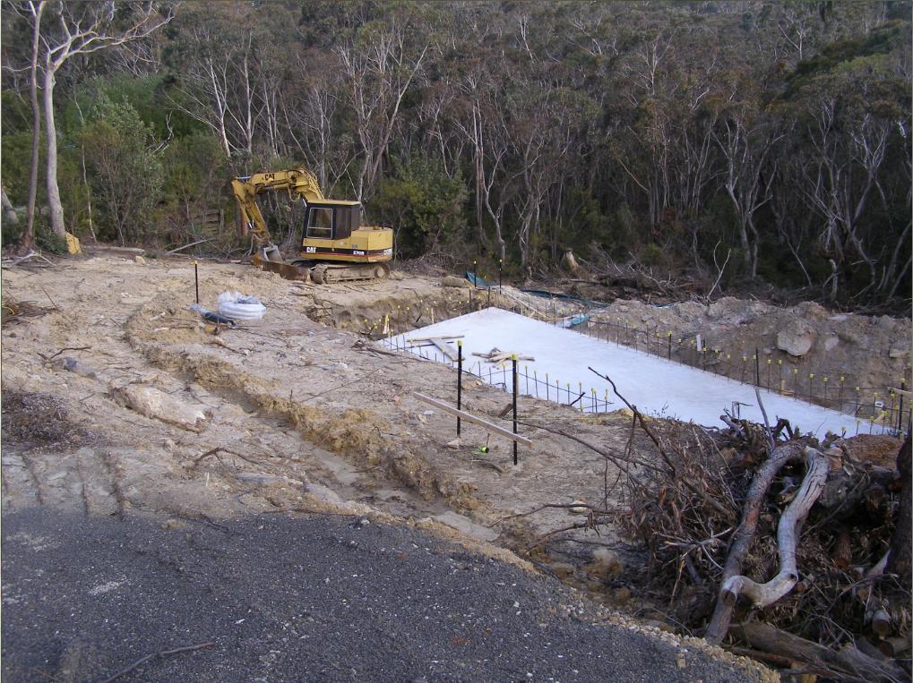
Friday, July 5th, 2013
 Katoomba Golf Club this week has been placed into administration – about time!
[Photo by Editor, 20130507, Photo © under ^Creative Commons] Katoomba Golf Club this week has been placed into administration – about time!
[Photo by Editor, 20130507, Photo © under ^Creative Commons]
.
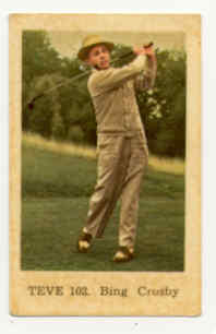
Actor Bing Crosby used to famously play golf back in the 1950s, but in 2013 who plays golf but the last of retired male Baby Boomers? The sport is a ‘has been’ and most courses have been constructed necessitating broadscale habitat destruction, and arrogantly so.
Golf’s origins date back to 15th Century Scotland and to the exclusive pastime of its landed gentry – male gentry, one for Gentlemen Only Ladies Forbidden. Along with croquet and lawn bowls, it dates to a bygone era – up there with duelling, archery practice and pheasant hunting.
This week we learn about the demise of another golf club struggling to attract new members as its 20th Century members ‘pass on’.
In the Blue Mountains west of Sydney, the Katoomba Golf Club as registered body formed just over a hundred years ago back in 1911. The land on which Katoomba Golf Club sited Katoomba Golf Course after the war in May 1923, had few previous owners in historic times.
A brief reflection on relevant colonial history
In the 18th Century, the island continent we now call Australia, was considered ‘undiscovered’ by the then dominant global European powers that be. In 1768, the then head of state of the Kingdom of Great Britain and Ireland, King George III commissioned his Royal Navy to undertake a world expedition voyage under the command of Lieutenant James Cook (combined with Botanist Joseph Banks of the Royal Society) to the south Pacific Ocean aboard HMS Endeavour, which took place between 1768 to 1771. Amongst the voyage’s prescribed tasks were to observe the 1769 transit of Venus across the Sun (3–4 June that year), and to seek evidence of the postulated Terra Australis Incognita or “undiscovered southern land”, plus other exploratory, naturalist and mapping duties.
In April 1770, the voyage famously became the first known European expedition to reach the east coast of Australia, mapping the coastline and making landfall near present-day Point Hicks, and then proceeding north to Botany Bay, naming the land New South Wales.
On 21st August 1770, Cook’s exploration party stepped ashore on an island in the Torres Strait situated 2km off now Cape York Peninsula (since called Possession Island) and declared possession of this “undiscovered southern land” to the British Crown. This was on the basis of unilateral possession – the land perceived as ‘terra nullius’, being Latin for ‘land belonging to no one’, because Cook and Banks considered there were few ‘natives’ along the coast and deduced that there would be fewer or none inland.
Subsequently, the British colonial First Fleet arrived at Botany Bay then Port Jackson in 1788 to establish a British convict settlement was set up in New South Wales.. The Proclamation of NSW Governor Richard Bourke in 1835 implemented the legal principle of terra nullius in Australian law as the basis for British settlement, 47 years later. Such were the powers that prevailed at the time. Various ‘frontier wars’ were waged sporadically between the Aboriginal peoples and the vastly out-weaponed British military and colonists for 46 years (1788-1934). By 1901, Australia was universally declared a unified federated nation state – The Commonwealth of Australia.
This island continent had been ‘legally owned’ (possessed) by the British Crown since Cook’s authorised declaration of possession in 1770. From 1788, the British penal colony of New South Wales was ruled by successive British military governors of the Colony of New South Wales. Until 1824, the military governors of New South Wales were absolute rulers with rights granted to them under an Act of the British Parliament of 1787. The only power superior to them being the British Parliament at Westminster in London, England.
History is history.
So, back to the land of Katoomba Golf Course – obtained historical written records show that the land site was then ‘legally owned’ by the London Chartered Bank of Australia from at least as far back as the 1870s. Katoomba was then not a settlement. Only a sandstone rock quarry ‘The Crushers‘ is historically documented to be in the area to supply ballast for the new railway line roll-out from the 1860s to 1874 when a railway siding was built. It appears that soon afterwards, English migrant (entrepreneurial merchant, miner then property developer) John Britty North acquired vast acreage around the south western area of The Crushers, which would become called the township of Katoomba.
Thus far, our research has not revealed how the local council happened to acquire the land of what would become granted to Katoomba Golf Club in 1920 to deforest the bushland for a golf course. In 1889, Blue Mountains Council did not exist, rather it was one of a number of smaller regional municipal councils across the central Blue Mountains, then it being termed the Katoomba Municipal Council Incorporated).
This is an historic legal document we have obtained that reveals the original deal dated 28th January 1920 between the Katoomba Golf Club and the then local council. At the time the deal was in fact legally between ‘The South Katoomba Land Company Limited‘ and ‘The Council of the Municipally of Katoomba‘. The former was the registered legal body that certain local business owners had established as a legal entity, and the then legally named local council.
 Loading...
Now this is a good revealing read. How’s these stated legal requirements for instance:
-
“Council at its own expense… (read Clause 1), (read Clause 2)”
-
(Clause 3) “THAT the said Council its successors and assign will not at any time erect on the said land any dwelling house or other building except a golf club house or a tennis court or croquet cloub house or a club house for any other purpose for recreation as allowed by paragraph (a) 2 and sheds outhouses stables and other buildings in connection herewith.”
The land was then owned by the then Katoomba Council (i.e. by the local community). The land was acquired from the local council for £1500 by property developers under the name of the South Katoomba Land Company. Was the escarpment land paid for, loaned or gifted? A nearby Gully was acquired a generation later from the Katoomba Council via a £27,000 loan to build a motor racing track, but the loan was never repaid.
So golf playing at the Katoomba Golf Club was in full swing from the 1920’s, and when Bing Crosby was playing during the post War 1950’s, golf was in its heyday. But by the end of the 1980s for reasons of waning interest, other competing interests for a four hour round of golf, busy lifestyles and basic economics; the Baby Boomer golf fad was fading. This was not just across Australia, but across America and elsewhere. Read the article at the end of this one by Nancy Keate, in The Wall Street Journal.
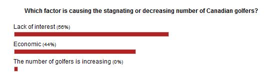
[Source: ‘Is Economy Or Lack Of Interest Hurting Golf?’, 20110523, by Ian Hutchinson ,
^http://www.golfnewsnow.ca/2011/05/23/is-economy-or-lack-of-interest-hurting-golf/]
.
“Over the past week, we’ve been discussing the declining number of golfers, both in Canada and the United States, a topic sparked by this story (see below) by Gene Yasuda of Golfweek.
Of course, the U.S. numbers used by Yasuda were provided by the National Golf Foundation, but here in Canada, we have no recent official numbers to go by, so it could be argued that there’s no cause for alarm about the number of Canadian golfers.
Some might even be tempted to lean on the crutch that Canada is among the world leaders in golfers per capita. Even if that is still the case, it doesn’t necessarily mean that the number of golfer isn’t dwindling.
All golf operators need to do is look out on their fairways and compare the number of golfers out there today to what it was five or 10 years ago to come to a realistic conclusion on how the number of golfers is affecting their businesses and whether it’s up, down or stagnant.
Of course, that number may be affected by the number of golf courses in a saturated market, but the feeling I get from different regions of the country leads me to believe that the number of overall golfers in this country is stagnating at best. If only there were numbers to back that up.
The consensus in the Golfweek story is that the U.S. numbers are affected mainly by the struggling American economy more than a lack of interest in the game.
Here in Canada, however, we’ve come out of the economic downturn a lot quicker that the U.S., but economic factors such as the price of gas and other inflation and the possibility of rising interest rates may be playing a part.
On the other hand, Canadian golf may be feeling the competition from other entertainment and recreation sources, which could indicate a waning interest in the game. While economic pressures on golfers might be a temporary factor, waning interest is more long term.
Which of those two factors do you feel is affecting the number of golfers in Canada? That’s the subject of this week’s GNN Poll.”
U.S. golf participation falls for third consecutive year
May 9, 2011 [SOURCE: http://golfweek.com/news/2011/may/09/us-golf-participation-falls-third-consecutive-year/]
“For the third consecutive year, the number of golfers in the U.S. declined, falling 3.6 percent to 26.1 million in 2010, according to the National Golf Foundation.
The slide, from 27.1 million golfers in 2009, wasn’t unexpected in light of the heavy toll the recession has had on the sport and the economy in general.
The silver lining, if any, according to NGF officials, is that the participation falloff is more linked to financial pressures rather than golf losing popularity among consumers.
“Multiple NGF studies of golfers since 2008 would attribute the gradual decline in golfers and rounds primarily to the impact of lower job security and concern over personal finances, not waning appeal for the game,” said Joe Beditz, NGF president and CEO.
The NGF supported that conclusion by citing golf’s continuing ability to attract “new” participants – in 2010 a total of 3.6 million, including 1.5 million first-time beginners and 2.1 million returning former golfers.
That gain, however, was negated by the loss of 4.6 million golfers who played in 2009 but not in 2010. According to the NGF, the number of new golfers held steady while the number of those who left the game decreased significantly. In recent years, golf industry leaders have been emphasizing improving the retention of golfers.
For all their efforts, though, the downward trend of participation remains a major concern. By comparison, the number of golfers in the U.S. in 2000 and 2005 was 28.8 million and 30 million, respectively.
Among the other findings:
-
-
- The number of “core” golfers (eight or more rounds annually) dropped to 14.8 million – down 3.6 percent from 15.3 million in 2009.
- “Occasional” golfers suffered a similar decline: a drop of 3.7 percent to 11.3 million from 11.8 million in 2009.
- The number of rounds played in 2010 was 475 million, down 2.3 percent from 486 million in the previous year. (By comparison, rounds played in 2000 and 2005 was 518 million and 500 million, respectively.)
The participation study defines a golfer as a person, age 6 or older, who plays at least one round of golf in a given year. Its results are “derived from a multi-sport study of 40,000 Americans, executed in conjunction with the Sporting Goods Manufacturers Association,” the NGF stated.
Yet, despite this general waning interest in golf and despite specifically the falling membership at both Katoomba and nearby Leura golf clubs, some Baby Boomers in complete denial decided in the 1990s to expand the Katoomba golf course from 9 holes to 18. [Editor’s Corrigendum: Correspondence received from an informed reader after publication, has confirmed that the golf course was in fact expanded from 9 holes to 18 holes circa 1927 (^Source). The development works circa 1995 instead relate to expansion of the course acquiring 5.6 hectares of adjoining community zoned woodland alongside Narrow Neck Road in order to build 13 townhouses and a resort hotel. Also circa 2007, a fairway/green was extended into bushland near Stuarts Road.] Further, they had grandiose notions of building a dozen new dedicated golfing townhouses next to the clubhouse, so perpetuating the ‘has-been’ American trend of the 1980s.
Where did the millions in development finance come from and how much was put up by local Blue Mountains Council negotiated behind closed doors claiming a dubious excuse fo commercial in confidence” dealing with this being zoned ‘Community Land‘ ?
Of course, this development necessitated a considerable acquisition of more surrounding bushland to be logged, the vegetation slashed and bulldozed, the soils landscaped, grassed and fertilised. This has meant permanent destruction of the ecosystem just like open cut mining. All this occurred immediately above and upstream of the Jamison Valley wilderness, now part of the Blue Mountains World Heritage Area.
.
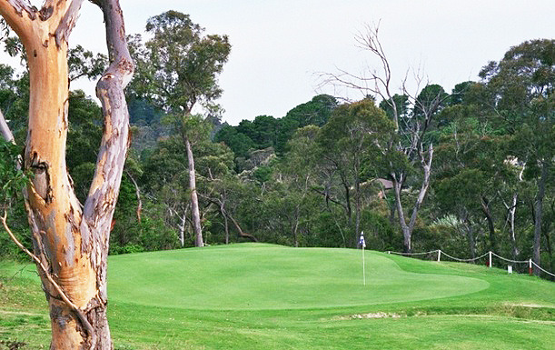
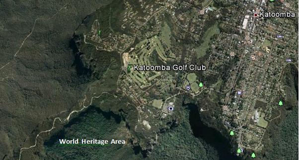 Juxtaposition of the Katoomba Golf Club (light green coloured fairways) replacing virgin habitat across the escarpment; all so that a few retiring Baby Boomer men can selfishly play golf at the expense of Ecology.
[Source: Google Earth, 2013] Juxtaposition of the Katoomba Golf Club (light green coloured fairways) replacing virgin habitat across the escarpment; all so that a few retiring Baby Boomer men can selfishly play golf at the expense of Ecology.
[Source: Google Earth, 2013]
.
During the construction of the additional nine holes [Editor’s Corrigendum: The construction instead related to building 13 townhouses and a resort hotel], the development proposal submitted to the local Blue Mountains Council, specified a new track would be constructed through adjacent bushland to connect two fairways. It was deceptive, because that track became a new wide fairway, complete with soil replacement, landscape contouring, grass seeding and fertilizer.
Repeated instances of sediment run-off from the construction were formally reported to the local Blue Mountains Council by concerned local residents, yet no remediation action was undertaken and no punitive fines were issued.
.
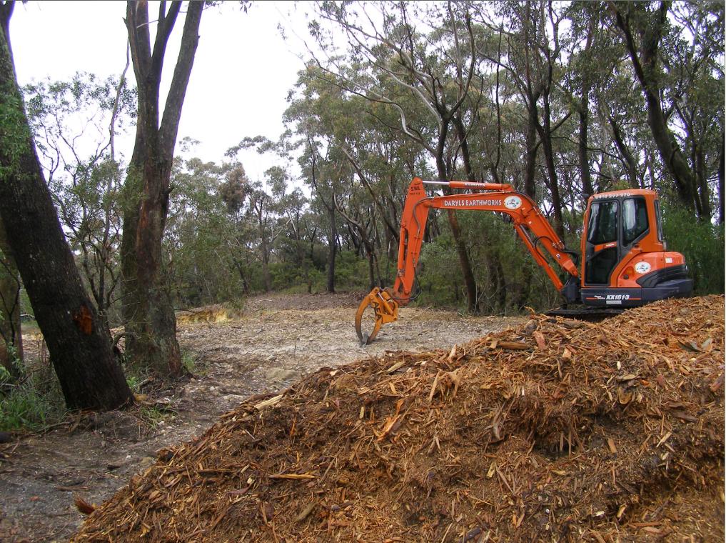 Native bushland along the Blue Mountains escarpment slashed and woodchipped to expand the Katoomba Golf Club out to 18 holes
[Editor’s Corrigendum: The construction instead related to building 13 townhouses and a resort hotel]
[Photo by Editor, 20071110, Photo © under ^Creative Commons] Native bushland along the Blue Mountains escarpment slashed and woodchipped to expand the Katoomba Golf Club out to 18 holes
[Editor’s Corrigendum: The construction instead related to building 13 townhouses and a resort hotel]
[Photo by Editor, 20071110, Photo © under ^Creative Commons]
.
.
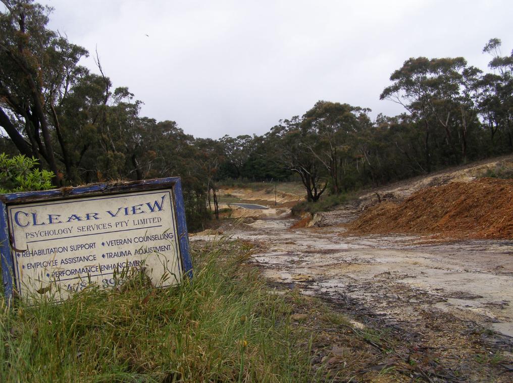 Native bushland bulldozed to make way for golfing townhouses adjacent to the Katoomba Golf Club
Erosion and sediment run-off has been rife for years
[Photo by Editor, 20071110, Photo © under ^Creative Commons]
Native bushland bulldozed to make way for golfing townhouses adjacent to the Katoomba Golf Club
Erosion and sediment run-off has been rife for years
[Photo by Editor, 20071110, Photo © under ^Creative Commons]
.
Golf courses not only necessitate absolute ecological destruction in such places, but the ongoing maintenance of the fairways and greens demands constant fresh water irrigation. Irrigation, as with farming, risks causing saline intrusion into the groundwater.
The keeping of golfing greens green to uphold the lush traditional image, necessitates that golf courses use extensive amounts of chemical fertilizers containing elevated levels of nitrogen (as sulphate of ammonia), potash , sulphur and phosphorus, as well as the application of pesticides and herbicides. All such chemicals are toxic to Australian native vegetation and to aquatic wildlife in the downstream watercourses. Effectively they are environmental pollutants and so next to and upstream of vital World Heritage, use of such chemicals needs to be legally banned.
The local Blue Mountains Council has failed to monitor run-off from the construction activity into the surrounding natural environment. The custodian of the World Heritage Area, National Parks and Wildlife Service, simply isn’t interested.
.
.
 White Elephant golfing townhouses adjacent to the Katoomba Golf Club that have since stood vacant for years
[Photo by Editor, 20071110, Photo © under ^Creative Commons]
.
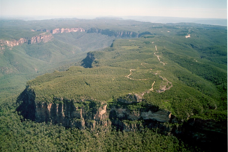 << It’s big, blue and beautiful! Blue Mountains National Park is located just 60 kilometres west of Sydney. It is unique in it’s history, its wildlife and world famous scenery…includes the Grose Wilderness, dedicated for its wild unspoilt natural beauty. At Katoomba see the Three Sisters and Katoomba Falls… 300 kilometres of heritage walking tracks and hundreds of lookouts, most within easy reach of a string of train stations. It’s a wilderness made easy to get to! >> << It’s big, blue and beautiful! Blue Mountains National Park is located just 60 kilometres west of Sydney. It is unique in it’s history, its wildlife and world famous scenery…includes the Grose Wilderness, dedicated for its wild unspoilt natural beauty. At Katoomba see the Three Sisters and Katoomba Falls… 300 kilometres of heritage walking tracks and hundreds of lookouts, most within easy reach of a string of train stations. It’s a wilderness made easy to get to! >>
[Source: NSW Government, ^http://www.visitnsw.com/destinations/blue-mountains/katoomba-area/blackheath/attractions/blue-mountains-national-park]
.
[Ed: No mention of golf in the tourism promotion these days]
.
Katoomba Golf Club R.I.P.
.
<<..“the locksmith has been in” and the club is no longer trading.
Unfortunately the club has temporarily closed its doors to the public. They have appointed administrators to handle the business. We are no longer employed. We, the staff thank all of you for your patronage, your friendship, your laughs and your well wishes – it has been a wonderful and memorable time for all of us. A bit of a sad day for us, so thank you. >>
[Source: ‘Katoomba Golf Club shuts its doors’, 20130703, Blue Mountains Gazette, print, p.5, ^http://www.bluemountainsgazette.com.au/story/1614280/katoomba-golf-club-shuts-its-doors/?cs=2062]
.
 Escarpment Karma?
Yet over 50 hectares of vital escarpment habitat has been lost
to a Baby Boomer selfish pastime. Escarpment Karma?
Yet over 50 hectares of vital escarpment habitat has been lost
to a Baby Boomer selfish pastime.
.
Notice of First Meeting of Creditors of Company Under Administration
.
Company: Katoomba Golf Club Ltd
ACN: 000 952 992
Status: Administrators Appointed
Appointed: 01 July 2013
.
Meeting details:
Notice is given that a first meeting of the creditors of the Company, or a first meeting for each of the Companies, (for multiple companies), will be held:
Location: Katoomba Golf Club, Acacia Street, Katoomba New South Wales
Meeting date: 10 July 2013
Meeting time: 12:00PM
.
[Source: ASIC Insolvency Notices].
.
.
‘Fore Sale – Luxury golf communities have hit a rough patch’
[Source: ‘Fore Sale – Luxury golf communities have hit a rough patch’, 20120724, by Nancy Keate, The Wall Street Journal, ^http://online.wsj.com/article/SB10001424052702303703004577474563368632088.html]
.
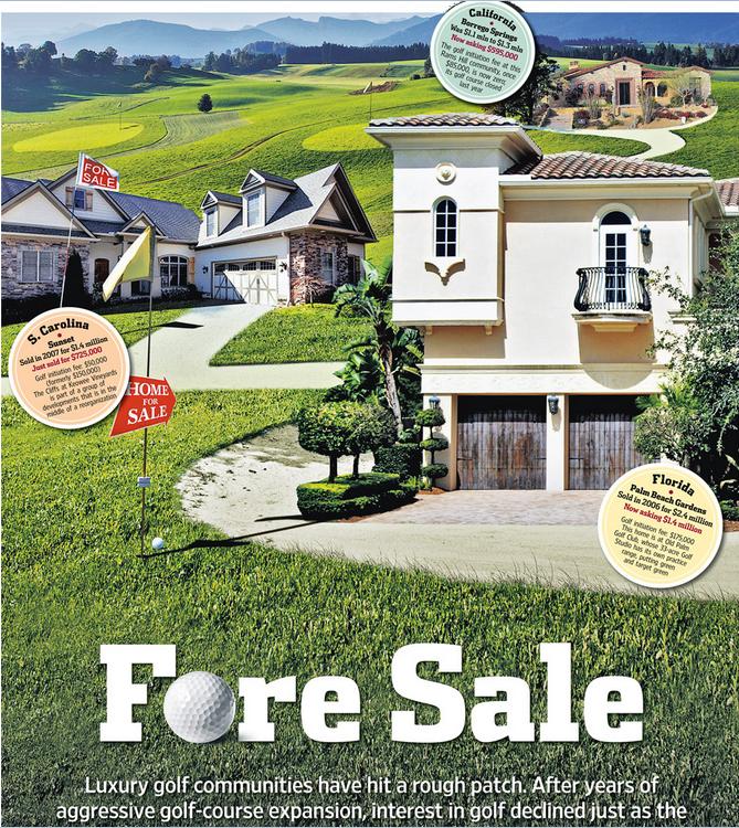 Photo Illustration: Jeff Huang
.
<< After years of aggressive golf course expansion, interest in golf declined just as the market for luxury homes plunged. Now, once-pricey real estate is available at below-par prices. Selling a lot for $1.
Debbie Bowers and her husband, tired of life in their cold Ohio town, spent eight years looking for a home near a sunny luxury golf course in a Southern state. Everything they saw was too expensive. Then this past May, they got a call: A lot was available at South Carolina’s Colleton River Plantation, one of the country’s premiere golf communities—for free.
Prices at luxury private golf communities are crashing, done in by rampant overdevelopment, the economic downturn and waning national interest in the sport. Nancy Keates has details on Lunch Break.
The seller was even willing to pay the $15,000 club initiation fee and the first year of $17,000 annual membership dues at Colleton River, which includes three celebrity-designed courses (two by Jack Nicklaus, one by Pete Dye), a Stan Smith-designed tennis center and a new 6,000-square-foot fitness center. Mrs. Bowers, 55, met her husband that day at the site and signed the papers. They’re now building a 3,000-square-foot house that should be finished by November.
The past two decades saw an unprecedented boom in the building of high-end golf courses linked to luxury real-estate communities. Betting that aging Baby Boomers would embrace golf as their pastime of choice, the National Golf Foundation set a goal of building “A Course a Day” beginning in 1988. Real-estate developers teamed up with top-name golf-course architects, building exclusive communities adjacent to courses, and requiring homeowners to pay annual club dues—sometimes even if they didn’t play. Then, in a moment of spectacularly bad timing, both the golf industry and the real-estate market took a nose-dive at once.
Now, private golf communities are dealing with the fallout. Many sellers are dropping their prices radically, in some cases even paying people to take their land. Gated communities that once traded on their exclusivity are aiming to appeal to a wider swath of buyers, building family-friendly “village centers” with ice cream shops, hiking trails and bowling alleys. A few are even “repurposing” by reducing courses to nine holes from 18 and selling off the reclaimed land.
At golf communities near Bluffton, S.C., like Belfair Plantation, Colleton River Plantation and Berkeley Hall, several lots that initially sold for at least $150,000 are now on sale for $1 apiece. Investors who bought but never built on the sites are trying to unburden themselves of the thousands of dollars—typically $12,000 to $17,000—they still have to pay in annual club dues.
At the Mizner Country Club in Delray Beach, Fla., which has an Arnold Palmer golf course, a lakefront home with five bedrooms, a pool and a spa is asking $795,000. It sold for $1.6 million in 2007. A lot in Horseshoe Bay Resort, near Austin, Texas, that sold previously for $300,000, is on sale for $39,000.
In Bend, Ore., interior designer Ronda Fitton and her husband paid $500,000 for a lot at Pronghorn, a gated community with golf courses designed by Tom Fazio and Jack Nicklaus, in 2006. A similar-size lot sold for $10,000 earlier this year. Ms. Fitton is hopeful values will go up but she says the lot is “worth nothing now. It’s a real bummer.” (Lot prices exclude membership fees.) Lots at Rams Hill in Borrego Springs, Calif. are also selling for about $10,000, compared with $100,000 at the peak.
The housing downturn is partly responsible. But the crash in value has been exacerbated by a development binge that resulted in too many courses just as the sport of golf began to fade in popularity.
From 1990 to 2003, some 3,000 new courses were built in the U.S., swelling the total number of courses nationally by 19% and costing about $20 billion, according to the National Golf Foundation.
Many of these new courses were inextricably linked to the luxury-real-estate market. About 40% of the courses built during the 1990s were tied to real-estate communities—a shift from the previous decades, when that number was closer to 18% and the vast majority of golf courses didn’t have people living on them. The golf courses were the lure to get people to buy houses: The bigger the name of the architect who designed them, the greater the prestige and the more expensive the real estate.
Soon after, however, the sport started to lose its allure. The percentage of the overall population in the U.S. that plays golf is down over the past 10 years, from 11.1% in 2000 to 9.2% in 2010, according to the National Golf Foundation.
Last year the number of rounds played in the U.S. dropped to 463 million from 518 million in 2000. The number of golfers fell to 25.7 million in 2011 from 28.8 million in 2000. A net of more than 350 golf courses have been closed since 2005. In 2011, more than 150 courses closed, outpacing the 19 courses that debuted last year.
Compounding the problem: Real-estate developers didn’t think about the viability of the golf courses themselves, says Art West, founder of Golf Course Advisors, a golf-course consulting company. Many of these courses designed by brand-name golf-course architects were championship-level, too difficult for the average player. They took a long time to play and cost millions a year to maintain, pushing up annual dues.
“It was a perfect storm,” says David Hueber, former president and CEO of the National Golf Foundation, who wrote a paper called ” ‘Code Blue’ for U.S. Golf Course Real Estate Development” stemming from research for his Ph.D. in real-estate development at Clemson University.
Across the country, about 2,000 of the 16,000 golf courses are “financially distressed,” according to the National Golf Foundation. Mr. Hueber estimates that 4,000 to 5,000 golf courses will be in financial danger if they don’t change their model.
Membership fees for many clubs have tumbled. The initiation fee at Old Palm Golf Club in Palm Beach Gardens, Fla., which was as high as $250,000 in 2007, is now down to $175,000, while the fee at Tiburon Golf Club in Naples, Fla., is now at $50,000, compared with $145,000 at its peak.
In some parts of the country, the premium that home buyers are willing to pay for a house on a golf course versus a house that isn’t on a course has dropped to about 25%, from 50% in 2007, says Doug Schwartz, who runs the sales, marketing and homebuilding operations for WCI Communities, in Bonita Springs, Fla., which currently owns four golf communities. Lisa Treu, an agent with the Treu Group in Palm Beach County, says homes on golf courses in Southeast Florida could at one time command a 25% premium over non-golf-course homes; that premium has now dropped to about 10%, she says. (Some areas are still strong, like Palm Springs, Calif., where agents say the premiums are as much as 35%).
“There are a lot of people who would like to get out of here because of the economy,” says Don Davis, who with his wife bought a house in South Carolina’s Colleton River for $970,000 in 2001. The couple, who have loved living in the community but want to move back to Atlanta to be closer to their grandchildren, say it doesn’t make financial sense to move without selling their house because they’d still have to pay the community’s annual membership dues of some $17,000. Their house, listed at $775,000, hasn’t had any offers in its six months on the market.
Real-estate agent Dick Datz of Carolina Realty Group says Belfair and Colleton River are offering agents a $5,000 bonus when they sell a $1 lot; otherwise the commission would be pennies. Rob Norton, president of the Colleton River Plantation Board, says houses in the community are selling and there’s lots of new construction. It’s mostly the people who bought the land as an investment who are having a hard time, he says.
Some developers are recasting their golf communities to appeal to a broader swath of home buyers, including more families and young people. One example: Tuscany Reserve, a 450-plus-acre private golf community in Naples, Fla., which had about $200 million invested in its infrastructure, including a golf course designed by Pete Dye and Greg Norman, before it went bankrupt. Florida developer Syd Kitson recently bought the community for $30 million and changed the name to Talis Park, which he thought sounded more youthful. Instead of building a clubhouse as planned, Mr. Kitson, will build a “village center” with a cafe, a spa and walking paths. Homes are now expected to be in the $700,000-to-$2 million range instead of up to $6 million, as originally intended.
“The model of a country club in its current form is gone forever,” says Mr. Kitson.
After seeing sharp decreases in its sale prices, Pronghorn, the gated community in Bend, Ore., opened its gates, launching a 48-suite lodge in 2010 and inviting the public to use one of its two golf courses. The Resort Group, a resort operator based in Honolulu, Hawaii, took over in February and announced it will bring in Auberge Resorts to manage the property, turning it into a five-star resort with a spa, three restaurants, two pools, tennis courts and a kids club.
The Cliffs—a group of eight residential developments spread among 20,000 acres between Greenville, S.C., and Asheville, N.C., with golf courses designed by Jack Nicklaus and Tom Fazio—filed for U.S. Bankruptcy Court protection in February, with estimated liabilities between $100 million and $500 million. A planned golf course for the Cliffs, designed by Tiger Woods, hasn’t been started. According to a 2007 news release, the Cliffs sold 40 lots in the $500,000 price range, and lots at that time couldn’t be purchased below $200,000. Earlier this year a lot sold in one high-end community for less than $10,000, according to real-estate agent Justin Winter.
Owners at the Cliffs, who tried to bail it out earlier by putting up $64 million to keep the club operating, say they are optimistic and are in the midst of a reorganization with Carlile Group, a diversified company based in Marshall, Texas. Carlile is working with two other groups.
Owners say the revamped club will have more options for membership. The initiation fee, which was $150,000, is now $50,000. “We are working diligently to find and deliver the best solution for all members and property owners at the Cliffs,” Steve Carlile of Carlile Group says in a statement.
Golf-course architect Bobby Weed of Bobby Weed Golf Design has been helping residential golf communities over the past few years “repurpose”—by compressing the properties. He is currently working on several proposals to shrink 18-hole courses to nine holes. At the Deltona Club in Deltona, Fla., he helped reduce the amount of land used by the clubhouse and the golf course to create a separate, 17-acre parcel for development.
The steep decline in prices is a boon for potential buyers, of course. “Now I’m getting worried I’m going to miss out if I don’t move quickly,” says Gordon Flach, 44, who has been looking for a golf resort home in Montana, Utah or Oregon for the past three years. Mr. Flach, who is part owner of a resort in the Bahamas, has his eye on a $425,000, 3,800-square-foot four-bedroom house in Pronghorn. A similar house was going for $1.1 million when he first started looking.
Ron Ruff, a 55-year-old semiretired anesthesiologist, got his lot at Pronghorn free about a year ago. The seller also kicked in part of the $115,000 reimbursement of his golf-club membership initiation fee he got back when he “sold” the land. Mr. Ruff says that he felt, despite the dire climate and other people thinking he was crazy, that Pronghorn has a “magical” feel and that the value would be realized again, just as he had seen happen in other areas before. His house is now complete.
John Reed, the original developer of Colleton River Plantation, Belfair Plantation and Berkeley Hall, concedes there are too many golf-course communities. “There’s a train wreck in the industry now,” he says. “We overbuilt and the market stopped.” He had Pete Dye and Tom Fazio design a golf course for his latest development, called Hampton Lakes, but decided to nix it in favor of a 165-acre freshwater fishing and boating lake.
“The best golf course we ever did is 9 feet underwater,” he jokes. >>
.
Tags: baby boomer, Blue Mountains Council, Blue Mountains Escarpment, Blue Mountains World Heritage Area, BMCC, broadscale habitat destruction, chemical fertilizers, Community Land, eco-rapist sport, escarpment slashed, golf, golf course development, golfing townhouses, institutionalised sport, irrigation, Jamison Valley Wilderness, Katoomba Golf Club, run-off, The Escarpments
Posted in Blue Mountains (AU), Threats from Development, Threats from Selling Public Land, Threats from Tourism and Recreation | 8 Comments »
Add this post to Del.icio.us - Digg
Saturday, June 22nd, 2013
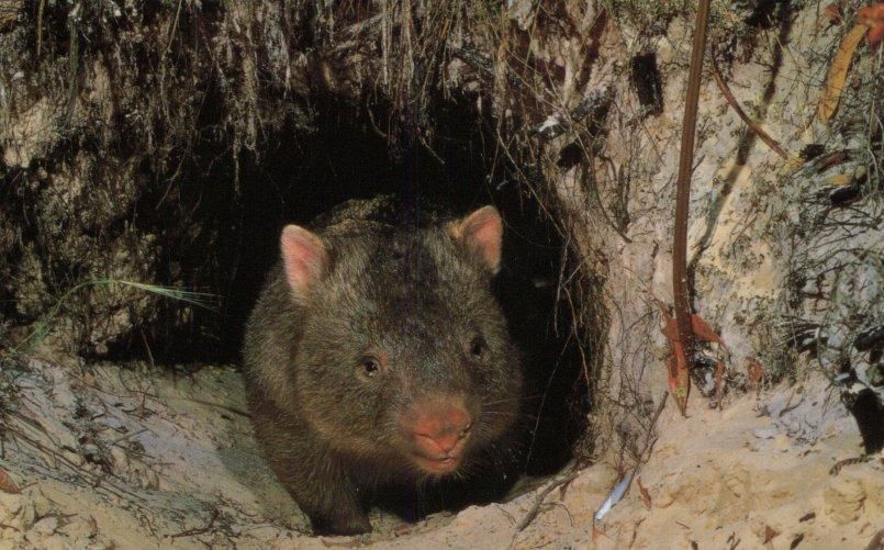
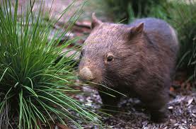
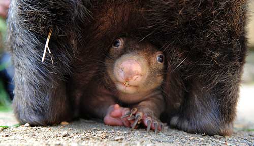
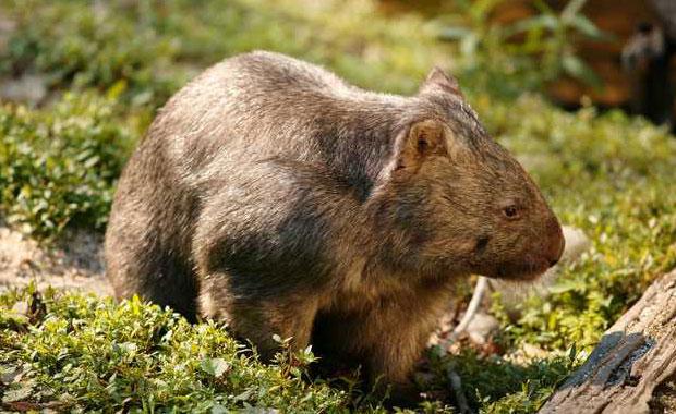 Common Wombat
(Vombatus ursinus)
A legally protected native animal throughout Australia
[Source: Healesville Sanctuary, Victoria, Zoos Victoria,
^http://www.zoo.org.au/healesville/animals/wombat] Common Wombat
(Vombatus ursinus)
A legally protected native animal throughout Australia
[Source: Healesville Sanctuary, Victoria, Zoos Victoria,
^http://www.zoo.org.au/healesville/animals/wombat]
.
June 2013:
.
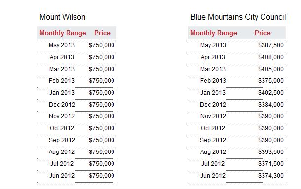
Tragically, a native Wombat has been deliberately poisoned this month in Mount Wilson in the Blue Mountains, and so the New South Wales National Parks and Wildlife Service (NPWS) is appealing for information from the local community.
Ranger Neil Stone of the NPWS Blue Mountains Region:
“A Wombat was recently found at Mount Wilson village (population 220), suffering from what a local veterinarian thinks was poisoning and sadly the animal had to be euthanized.
“Wombats become unpopular with landholders when they damage fences and infrastructure or trample on gardens. But there are methods, including installing Wombat Gates, that enable Wombats to pass through properties without damaging them.”
.
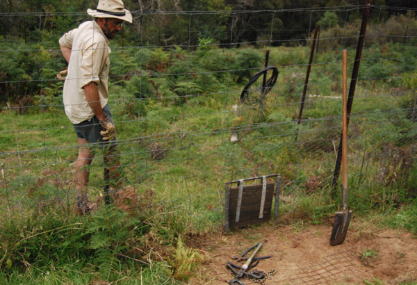 An example of a purpose-built Wombat Gate
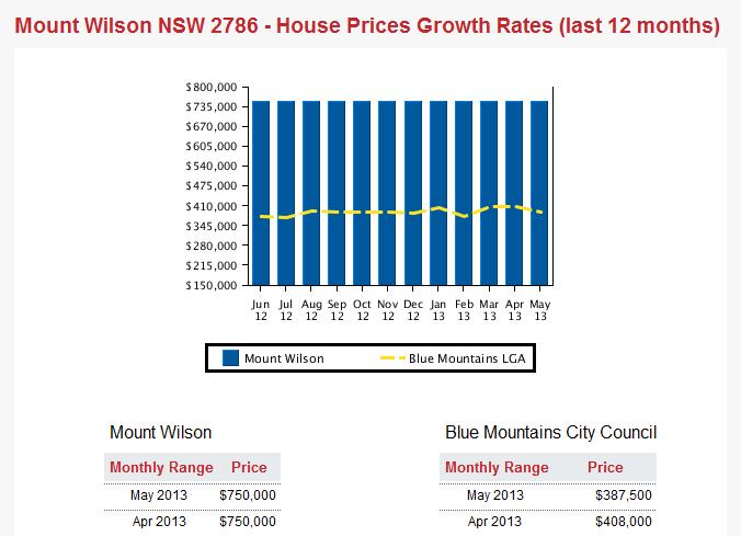
If one can afford property at exclusive Mount Wilson with average prices currently $750,000 [^Source]
then one can afford to contribute a few purpose-built Wombat Gates across their property,
constructed by wildlife experts who know what they are doing!
[Photo Source: Rocklily Wildlife Refuge, Taralga, NSW,
^ http://rocklilywombats.com/blog/rocklily-history/] An example of a purpose-built Wombat Gate
If one can afford property at exclusive Mount Wilson with average prices currently $750,000 [^Source]
then one can afford to contribute a few purpose-built Wombat Gates across their property,
constructed by wildlife experts who know what they are doing!
[Photo Source: Rocklily Wildlife Refuge, Taralga, NSW,
^ http://rocklilywombats.com/blog/rocklily-history/]
.
NPWS Ranger Neil Stone:
“Wombats are extremely strong and determined, constructing their burrows (often under homes) to escape from the heat and to hide from predators (typically domestic and feral dogs nowadays). The burrows can be up to 30 metres long which can cause conflict between Wombats and humans.”
“Wombats and all other native animals are protected under the National Parks and Wildlife Act 1974 and Regulations and it is illegal to harm them without a licence. There are fines and possible imprisonment for people found to have intentionally harmed native wildlife.”
.
[Source: ‘Not so divine: Wombat dies in suspected poisoning’, 20130612, Blue Mountains Gazette newspaper (print only), p.15]
.
Wildlife Poisoning is Animal Harm
.
Wombats being mammals are sentient animals, meaning that they feel emotion and pain. An animal is ‘sentient‘ if it is capable of being aware of its surroundings, its relationships with other animals and humans, and of sensations in its own body, including pain, hunger, heat or cold.
Individuals who harm animals including the harming of wildlife such as by poisoning, tend to harbour a personality disorder. Statistically, animal abusers are five times more likely to go on to commit violent crimes against people.
Deviant behaviors like animal abuse generally originate from a traumatic childhood. The American Psychiatric Association considers animal cruelty as one of the diagnostic criteria of conduct disorder.
The fourth edition of the Diagnostic and Statistical Manual of Mental Disorders (DSM) defines conduct disorder as “a repetitive and persistent pattern of behavior in which the basic rights of others or major age appropriate societal norms or rules are violated.” Conduct disorder is found in those who abuse animals and abuse people.
Clinical evidence indicates that animal cruelty is one of the symptoms usually seen at the earliest stages of conduct disorder, often by the age of eight. This information has only recently been included in the DSM so some psychologists, psychiatrists, and social workers are just now becoming aware of it. Many psychological, sociological and criminology studies in recent decades have clearly shown that violent offenders have adolescent histories of serious and repeated animal cruelty.
Director of People for the Ethical Treatment of Animals (PETA) Asia, Jason Baker, has said, “We believe that cruelty to animals is not inherent, but learned. That being said, teaching kindness and respect for animals – in our schools and homes – will foster empathy, the ability to understand what someone else feels.” He added, “Incorporating the simple concepts of kindness and respect into our daily lives and teaching our children to respect and protect even the smallest and most despised among us will help kids value one another.”
The link between animal abuse and interpersonal violence is becoming so well established that many U.S. communities now cross-train social-service and animal-control agencies in how to recognize signs of animal abuse as possible indicators of other abusive behaviors. >>
.
[Source: ‘Animal Cruelty Syndrome’, by Canadians for Animal Welfare Reform, ^http://cfawr.org/animal-abuse.php]
.
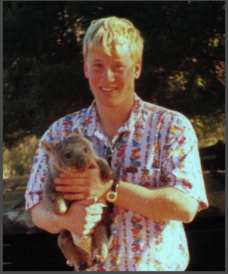 Martin Bryant as a teenager nursing a juvenile Wombat
Bryant reportedly tortured animals as a child.
In 1996, at age 29 Bryant murdered 35 people and injured 21 others
at Port Arthur Tasmania Martin Bryant as a teenager nursing a juvenile Wombat
Bryant reportedly tortured animals as a child.
In 1996, at age 29 Bryant murdered 35 people and injured 21 others
at Port Arthur Tasmania
.
Penalties in NSW for Harming protected Fauna
.
.
Sect 98 ‘Harming protected fauna, other than threatened species, endangered populations or endangered ecological communities’
.
(Ed: i.e. Wombats)
.
(1) In this section, protected fauna does not include threatened interstate fauna, threatened species, endangered populations, endangered ecological communities, or locally unprotected fauna under section 96.
(2) A person shall not:
(a) harm any protected fauna, or (a1) harm for sporting or recreational purposes game birds that are locally unprotected fauna, or
(b) use any substance, animal, firearm, explosive, net, trap, hunting device or instrument or means whatever for the purpose of harming any protected fauna.
.
Maximum penalty:
.
(a) 100 penalty units and, in a case where protected fauna is harmed an additional 10 penalty units in respect of each animal that is harmed, or
(b) imprisonment for 6 months, or both. >>
.
Note: As at 2013, 1 penalty unit in NSW equates to $110. So 100 +10 penalty units incurs a fine of $12,100 per protected Wombat harmed [Calculation: (100 + 10) x $110]
.
[Sources: National Parks and Wildlife Act 1974, No 80, Section 98, (historical version but this section still current), pp 149-150, ^http://www.environment.nsw.gov.au/legislation/NationalParksAndWildlifeAct1974.htm ; ^http://en.wikipedia.org/wiki/Penalty_units]
.
.
.
So who killed the Mt Wilson Wombat?
.
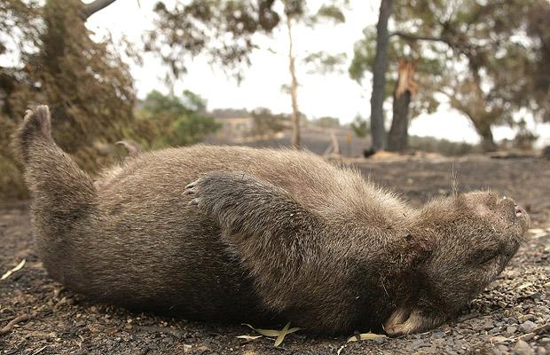 A common Wombat sight
…”Just Roadkill”
A common Wombat sight
…”Just Roadkill”
.
It is likely that Mount Wilson’s Wombat was poisoned by an ignorant and frustrated local landholder. He is one of just a few hundred residents living at remote Mount Wilson village, and probably he is some arrogant newcomer with no respect for the natural environment or its resident wildlife who were there first. It is extremely rare for a female to commit wildlife poisoning.
The perpetrator is likely to be someone holding an Anglicised mindset toward rural property, desiring the exotic deciduous garden and with a phobia towards the natural Australian bush. Whereas the more established residents tend to be respectful towards the special environment in which they live and have become more accommodating towards the place’s resident wildlife.
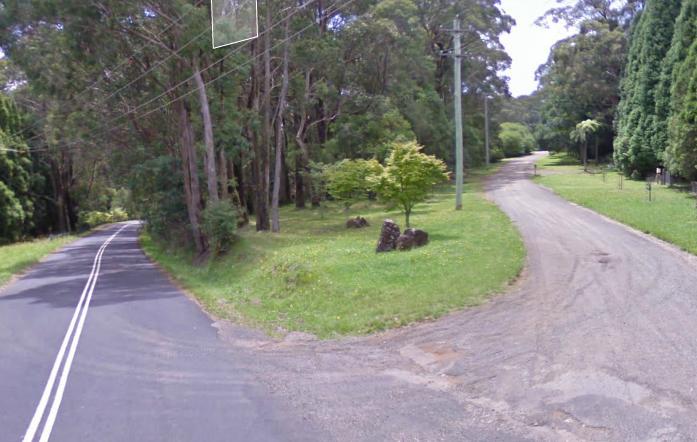
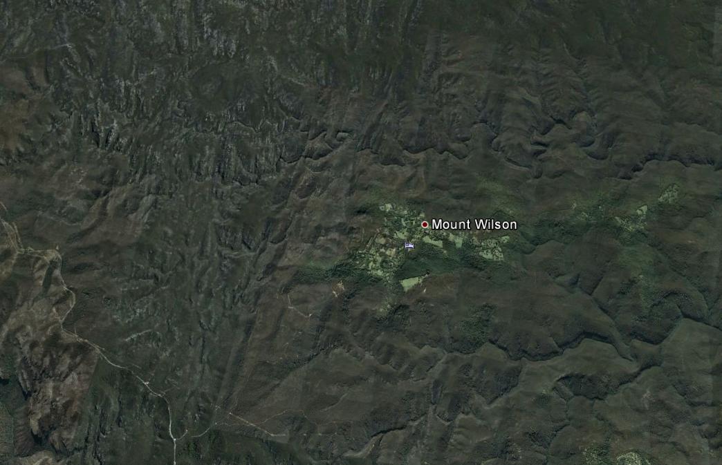 Mount Wilson lies in a remote forested wilderness region of the Blue Mountains
And the native Wombats have lived there thousands of years before
Colonial Deforestation
Housing Development
Anglicised Garden Romanticism
[Source: Google Earth]
(click image to enlarge) Mount Wilson lies in a remote forested wilderness region of the Blue Mountains
And the native Wombats have lived there thousands of years before
Colonial Deforestation
Housing Development
Anglicised Garden Romanticism
[Source: Google Earth]
(click image to enlarge)
.
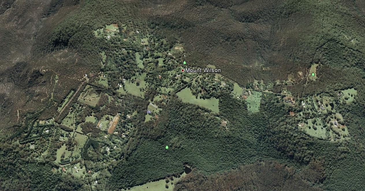 Mount Wilson
Best described as a remote hilltop residential hamlet
Situated on an ancient volcanic hill
Since the 1870s, logged, burned and settled by English colonists
amongst the ‘Wombat Holes’
[Source: Google Earth]
(click image to enlarge)
Mount Wilson
Best described as a remote hilltop residential hamlet
Situated on an ancient volcanic hill
Since the 1870s, logged, burned and settled by English colonists
amongst the ‘Wombat Holes’
[Source: Google Earth]
(click image to enlarge)
.
 Hillcrest Lane (right), Mount Wilson Hillcrest Lane (right), Mount Wilson
[Source: Google Maps, 2013]
.
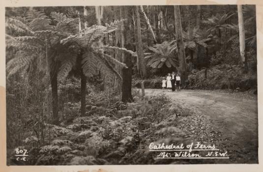 Mount Wilson before the Anglicising
[Source: Mt Wilson/Mt Irvine Historical Society, ^http://www.mtwilson.com.au/]
Mount Wilson before the Anglicising
[Source: Mt Wilson/Mt Irvine Historical Society, ^http://www.mtwilson.com.au/]
.
Consistent with the profile of the typical member of the Game Council NSW, the perpetrator is likely to be a middle-aged or older male Babyboomer approaching 65, having an anthropocentric worldview of Nature, and an evangelistic belief that economic growth and personal wealth accumulation is a right – Wombats being collateral damage in rural housing development.
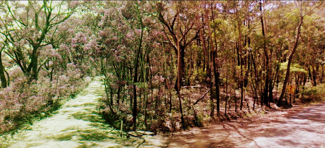 Mount Wilson bushland
.
The perpetrator has not yet been confirmed, and anyone with information about this harmful offence is asked to contact the closest NPWS base at the Blue Mountains Heritage Centre in nearby Blackheath.
.
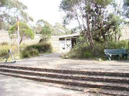 NPWS Blue Mountains Heritage Centre
Located towards the eastern end of Govetts Leap Road
outside the nearby township of Blackheath NPWS Blue Mountains Heritage Centre
Located towards the eastern end of Govetts Leap Road
outside the nearby township of Blackheath
.
.
.
The ‘Common‘ Wombat?
.
The Common Wombat (Vombatus ursinus) is also known as the Coarse-Haired Wombat or Bare-Nosed Wombat. In the case of the Bare-Nosed Wombat, this reference to its nose, distinguishes it from its other two subspecies, the Southern Hairy-Nosed Wombat (Lasiorhinus latifrons) and the endangered Northern Hairy-Nosed Wombat (Lasiorhinus krefftii).
The ‘Common Wombat‘ is a nocturnal marsupial native to south eastern Australia and is found in small sections of southeast tip of Queensland, eastern New South Wales, eastern and southern Victoria, and south-east South Australia. They are common throughout Tasmania and also on Flinders Island in Bass Strait.
The head of the Common Wombat is more rounded than that of the hairy-nosed subspecies. Their short ears are triangular and slightly rounded. Their nose is large, shiny black and furless. Their fur is coarser, thicker and longer than that of the Hairy-nosed Wombats, better suited to a colder, wetter habitat. Fur colour varies from sandy to brownish black or even grey, sometimes flecked.
.
 Bare-Nosed Wombat
a more respectful naming than ‘Common’ Bare-Nosed Wombat
a more respectful naming than ‘Common’
.
Wombats have short legs, and the second and third toes of the hind feet are fused, with a double claw used in grooming. Wombats are solid and stocky, with short legs and tail. Their front legs and shoulders are powerful. Their front feet are large, with bear-like long claws. They use their front legs for digging burrows. The dirt is pushed to one side and the Wombat backs out, moving loose dirt with front or back paws. It grows to an average of 98 cm long and up to a healthy weight of 26 kg.
Wombats are stilll classed as ‘least concern’ by the International Union for Conservation of Nature and Natural Resources (on the IUCN ‘red list’). [Ed: So were the Koala and Tasmanian Devil until recently].
At Healesville Sanctuary in Victoria, more than 2,000 sick and injured native animals treated each year including Wombats at its Australian Wildlife Health Centre.
[Source: Healesville Sanctuary, Zoos Victoria, Victorian State Government, ^http://www.zoo.org.au/healesville/animals/wombat]
.
 Situated on Badgers Creek
A place of inspiration to this Editor,
when visited as a child. Situated on Badgers Creek
A place of inspiration to this Editor,
when visited as a child.
.
Although Wombats have been named by European Australians as the ‘Common Wombat‘, their numbers and their existence value does not translate to anyone treating them as commonplace.
Common Wombats were once widespread from south-eastern Queensland, through NSW along the Great Dividing Range and most of Victoria. Now they have a fragmented distribution in NSW, being most abundant in the south-eastern parts of the state. Remaining populations are under continued pressure from land clearing, road mortality, disease and illegal shooting. These pressures may be acute for some local populations.
While the word ‘Wombat’ is derived from the Aboriginal name for the animal, ‘common’ was added at a time when these animals were plentiful and the Australian bush landscape relatively less destroyed by colonial settlement. Wombats were likened to European Badgers by the early colonists.
We prefer the more respectful name, ‘Bare-Nosed Wombat‘.
.
In 2010, university student Nikki Selles, from the School of Natural Sciences at the University of Western Sydney, undertook a field fauna study on Wombats in the Mt Wilson and Mt Irvine area. Due to the behaviour of slow moving, ground-dwelling Wombats being sensibly shy and noctural, Selles used camera-trap data to identify their habitat and distribution in the urban-bush interface.
Results ought to be obtainable from the university.
[Source: Mount Wilson and Community Newsletter, May 2010, ^http://www.mtwilson.com.au/images/stories/MWPA_Newsletters/May_2010.pdf]
.
While the Bare-Nosed Wombat is not yet threatened with extinction, the Northern Hairy-Nosed Wombat is endangered. This is mainly due to overgrazing by sheep and cattle destorying their fragile semi-arid habitat across more central Australia, as well as the culture of broadscale hazard reduction and uncontrolled bushfires.
Mount Wilson also provides vital native habitat for fauna species that are recognised as endangered. These include the Sooty Owl (Tyto tenebricosa), the Eastern Bent Wing Bat (Miniopterus schreibersii oceanensis), the Large eared pied bat (Chalinolobus dwyeri), Little John’s Tree Frog (Litoria littlejohni), and the Eastern False Pipistrelle (Falsistrellus tasmaniensis).
.
Living with Resident Wombats
.
 Wombats are locally territorial, like Humans
Try to relocate them, and they will stubbornly resist – even after repeated flood, drought, bushfire and earthquake
Ask any Human who has endured such tempest. Wombats are locally territorial, like Humans
Try to relocate them, and they will stubbornly resist – even after repeated flood, drought, bushfire and earthquake
Ask any Human who has endured such tempest.
.
<<Wombats are an iconic part of the protected fauna of NSW. They are extremely strong and determined animals.
They can build their burrows under Human-introduced houses, driveways and cattle stock routes. This may cause Humans inconvenience and conflict between Wombats and non-Indigenous Humans.
.
But Newcomer Humans need to respect that Wombats were there first.
Who likes Invasion or Displacement?
.
Human-Wombat conflicts can be respectfully resolved and accommodated by wisdom – by learning about the behaviour of Wombats and understanding their habitat needs.
The Bare-Nosed Wombat is the species most frequently found in NSW. They prefer temperate forested areas of the coast, ranges and western slopes. Slopes above creeks and gullies are favoured sites for burrows and they like to feed in grassy clearings, including farm paddocks.
.
Wombat Habitat Needs
.
Wombats construct burrows to escape the heat and hide from predators. They prefer areas where it is easy for them to dig. The burrows can be up to 30 metres long and several metres deep and are usually situated above creeks and gullies and may have multiple entrances. Active burrows are often characterised by fresh cube-shaped droppings and scratch marks as well as freshly dug soil at the burrow entrance. Wombats will often build more than one burrow within their home range of 5 to 25 hectares.
Wombats are mostly solitary animals, but overlapping home ranges can occasionally result in a number of Wombats using the same burrow. Wombats are possessive about their particular feeding grounds and they will mark out these areas by leaving scent trails and droppings. These markings are prominently placed on rocks and logs around the boundaries. If an intruding Wombat encroaches on another’s territory it will be discouraged through a series of snorts and screeches and at times physical aggression.
Breeding occurs year-round with each female typically producing one young. In some areas, however, Wombats are seasonal breeders and may have dependent young in burrows from April to June. Young Wombats take up to 21 months to reach full independence and two years to become sexually mature.
.
Wombat Behaviour
.
Wombats become unpopular with landholders when they damage fences and infrastructure or trample upon gardens. Undetected burrows can be a hazard to livestock as they may trip or fall into burrows and injure themselves.
Many of the problems caused by Wombats can be resolved with some patience and innovation. Landholders willing to share their property with Wombats may find that there are simple solutions to most problems. For example, a post or small strand fence can be used to mark burrows in paddocks or driveways to keep stock away from burrow entrances.
Wombats use the same trails to get to and from their preferred feeding areas. Instead of going around an obstacle, such as a fence, a determined Wombat will try to go through, or under it instead. Installing purpose-built ‘Wombat Gates’ at known Wombat breech points along a fence will allow them to pass through a fence without damaging it. The fence needs to continue to exclude other animals such as wallabies, rabbits and foxes.
Removing the lowest fencing wire (15 cm above ground level) will also allow Wombats to move through an area without damaging the fence. This is a much cheaper option than excluding them completely.
Check first with a Certified National Parks Wildlife Ranger.
.
Excluding wombats from Rural Property
.
It is possible to exclude Wombats from continuing to use a burrow that is under a building but this requires intervention by a Certified National Parks Wildlife Ranger.
.
Increasing Native Vegetation
.
Wombats prefer to burrow in areas of vegetation and rocky debris. Land clearing has forced Wombats to build burrows along creeks and drainage lines where vegetation still exists. Wombats are also often incorrectly blamed for causing erosion, which is more likely due to poor land management practices.
Planting trees and revegetating areas away from creeks can play a vital role in reducing Wombat burrowing activity along creek beds. Retaining existing trees, logs and rocks, and establishing new areas of native vegetation encourages Wombats to construct burrows in less fragile areas and reduces the risk of erosion.
Check first with a Certified National Parks Wildlife Ranger.
.
Trapping or Relocating Wombats Prohibited
.
The trapping and relocation of Wombats is prohibited and attracts heavy fines.
Wombats are territorial animals and if relocated, they are likely to be harassed or even killed by resident Wombats. Wombats are classified as protected fauna under the NSW National Parks and Wildlife Act 1974.
.
Can I bulldoze or infill a Wombat burrow?
.
No! Only inactive Wombat burrows may be destroyed, but each one needs to be first validated by a Certified National Parks Wildlife Ranger.
Bulldozing an active burrow can lead to wombats being buried alive and suffering a slow and painful death. Even if you have located an apparently vacant burrow, you must not fill it in without confirming that it is inactive. Burrow activity can be confirmed by placing sticks across each entrance and checking (every day for at least a week) if these are disturbed.
Remember that if you think you have an inactive burrow, check first with a Certified National Parks Wildlife Ranger.
contact your local National Parks office for expert verification before any action.
.
[Source: NSW Government, ^ http://www.environment.nsw.gov.au/animals/LivingWithWombats.htm#gate]
.
.
.
Further Reading
.
[1] Wombat Gate Design
^http://www.dpiw.tas.gov.au/inter.nsf/Attachments/LBUN-84H7FT/$FILE/Wombat%20gate%20design.pdf
.
[2] Guide to Living with Wombats
[Source: ^ http://www.naturalresources.sa.gov.au/samurraydarlingbasin/plants-animals/native-plants-and-animals/native-animals]
.
[3] National Parks and Wildlife Act (NSW) 1974
^http://www.austlii.edu.au/au/legis/nsw/consol_act/npawa1974247/
.
[4] Wombat Protection Society of Australia
^http://www.wombatprotection.org.au/
.
Why Do Wombats Need Protection?
Lack of Legislative Protection/Enforcement!
<< In Australia native animals are “the property of the Crown”. This means that no-one owns wombats, they can’t be kept as pets and to do anything with them you have to be licensed by government departments.
Government Departments do little to protect or help wombats. Most research and all welfare (rescuing injured wombats, raising the joeys of mothers killed in collisions with vehicles, removing wombats from unsuitable places) is undertaken by voluntary organizations. While penalties exist if someone is found to hurt or kill a wombat, the same government departments charged with wombat care issue permits to farmers to cull wombats. Sadly, there is often no check whether this is necessary, whether it is done humanely or any insistence that alternative options be employed before issuing such permits.
On the other hand although penalties exist for the illegal killing of wombats, such killing occurs every night where on a farms they are shot, buried alive and gassed and on the highways of Australia vehicles indiscriminately drive directly at wombats without penalty. Live joeys left in their dead mother’s pouches die slowly and a lack of public education means few Australians understand how to rescue a joey still living after its mother falls victim to road kill. >>
.
 The Crown
Disinterested in protecting Australian wildlife
The kangaroo and emu images are but token symbolism The Crown
Disinterested in protecting Australian wildlife
The kangaroo and emu images are but token symbolism
.
[5] The Wombat Foundation
^http://www.wombatfoundation.com.au/
.
<<The Wombat Foundation is a charitable organisation set up to support activities that aim to bring the Northern Hairy-nosed Wombat back from the brink of extinction.
The Northern Hairy-nosed Wombat is one of the world’s most endangered species – it is more endangered that the Panda.
In the 1980s, there were as few as 35 wombats remaining on the planet – all at Epping Forest National Park in central Queensland. A second population was established at Richard Underwood Nature Refuge in southern Queensland in 2009. At last count, in 2010, there were a total of 176 wombats across the two sites. Since then, the population has continued to grow: in 2012, the combined population at the two sites was estimated at 200 wombats. >>
.
[6] Wombat Awareness Organisation
^http://wombatawareness.com/
.
<<We are a charity established to help save the Southern Hairy-nosed Wombat (Lasiorhinus latifrons) from extinction.
The wombat is an Aussie icon but few people are aware of the peril these gorgeous little animals face: drought, floods, climate change, disease, vehicular incidents and culling – both legal and illegal. It’s not rocket science to see these animals are in trouble but thanks to the work of WAO volunteers, there is hope!
Currently, the wombats are being affected by an unidentified disease outbreak. The visual symptoms are hair loss and emaciation, internally the wombats are anemic and in some cases there is liver damage and heart disease. The direct cause is unknown however it is suspected that due to an increase in weeds there is a decrease in food availability therefore the wombats are forced to eat what they can most of which unfortunately is toxic. >>
.
[7] WIRES
NSW Wildlife Information, Rescue and Education Service Inc.
^http://www.wires.org.au/
.
[8] Rocklily Wildlife Refuge
Taralga, NSW, ^ http://rocklilywombats.com/blog/rocklily-history/
.
<<This website is about Rocklily Wildlife Refuge, and a few other wildlife carers we know in Australia too. Providing a safe place for our native flora and fauna and the various wildlife projects we are undertaking can be an expensive business, so we sell reasonably priced, quality Australian-made gifts and artisan products to raise money for our wildlife projects.
..This website has come about with our move to Rocklily Wildlife Refuge: a safe place for wild native animals just inside the SW border of the Greater Blue Mountains National Park, and within the locked gate of the Sydney Water Catchment. >>
.
[8] Healesville Sanctuary
^http://www.zoo.org.au/healesville
.
<<Healesville Sanctuary, or the Sir Colin MacKenzie Fauna Park, is a zoo specializing in native Australian animals. It is located at Healesville in rural Victoria, Australia (east of Melbourne), and has a rare history of successfully breeding Australia’s native animals.
.
[9] People for the Ethical Treatment of Animals (PETA)
^http://www.petafoundation.org/
.
[10] Voiceless, The Animal Protection Institute
Paddington, New South Wales
^https://www.voiceless.org.au/the-issues/animal-sentience
.
[11] The Cambridge Declaration on Consciousness
.
‘The Cambridge Declaration on Consciousness’, 20120707, by Philip Low, Paper presented at the Francis Crick Memorial Conference on Consciousness in Human and Non-Human Animals, Churchill College, University of Cambridge, England, ^http://fcmconference.org/img/CambridgeDeclarationOnConsciousness.pdf
<< In 2012, an international group of eminent neuroscientists signed The Cambridge Declaration on Consciousness, which confirmed that many animals, including all mammals and birds, possess the “neurological substrates that generate consciousness.” >>
.
.
[12] The Baby Boomers Who Destroyed the World
.
‘The Baby Boomers Who Destroyed the World’, 20110218, by Karlsie, in Subversify, ^http://subversify.com/2011/02/18/the-baby-boomers-who-destroyed-the-world/]
.
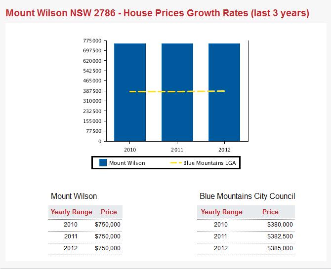
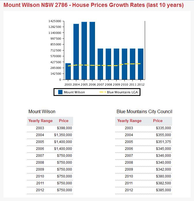
[13] Mount Wilson Property Prices
^http://reareports.realestate.com.au/house_prices_growth_rates/nsw/mount_wilson/2786
.
..
 . .
 . .
 . .
.
2013 Price?
.
Tags: Anglicising, animal cruelty, Animal Cruelty Syndrome, Animal Harm, Bare-Nosed Wombat, Blue Mountains, Coarse-Haired Wombat, Common Wombat, Living with Wombats, Martin Bryant, Mount Wilson, Mount Wilson Property, Mount Wilson Property Prices, Mount Wilson Real Estate, Mt Wilson, national parks and wildlife act, NSW National Parks and Wildlife Service, sentient, Wombat Gate, Wombat Habitat, wombat poisoned, Wombat Protection
Posted in Blue Mountains (AU), Threats from Development, Threats from Poaching and Poisoning, Wombats | 1 Comment »
Add this post to Del.icio.us - Digg
Sunday, March 31st, 2013
 A hundred year old native Eucalypt killed for housing development
Wellington Road Katoomba, Blue Mountains
[Photo by Editor, 20130307, click image to enlarge, Photo © ^Creative Commons] A hundred year old native Eucalypt killed for housing development
Wellington Road Katoomba, Blue Mountains
[Photo by Editor, 20130307, click image to enlarge, Photo © ^Creative Commons]
.
Month by month, year on year, the native vegetation of the Blue Mountains is steadily disappearing lot by lot, hectare by hectare, for private housing development profit.
A native bushland site along Wellington Road on the bush fringe of Katoomba has been recently sold off for private profit, then bulldozed and trees uprooted ready for housing construction. Like so many such sites, once the house is built, it soon goes on the market for sale and profit.
Typically, it is not owner-occupiers buying up the bush, but property developers for quick sale and profit. Cummulatively, much of fringe Blue Mountains bushland is being flogged for profit. Cheap bush blocks are bought, bushland habitat is destroyed and private profit is made at the expense of cheapened ecology.
And real estate agents are in on the private profit making bandwagon.
 Katoomba fringe bushland flogged by real estate agents
Oxymoronic zoning: ‘Living – Bushland Conservation’
[Photo by Editor, 20130307, click image to enlarge, Photo © ^Creative Commons] Katoomba fringe bushland flogged by real estate agents
Oxymoronic zoning: ‘Living – Bushland Conservation’
[Photo by Editor, 20130307, click image to enlarge, Photo © ^Creative Commons]
.
On this particular site, grows a threatened species of native flora, Needle Geebung (Persoonia acerosa), which is endemic to this region of the Blue Mountains – that is, outside this region, the species grows naturally nowhere else on the planet. It is a protected species under the Threatened Species Conservation Act 1995 (New South Wales).
 Blue Mountains Needle Geebung (Persoonia acerosa)
[Photo by Editor, 20130307, click image to enlarge, Photo © ^Creative Commons]
Listed as vulnerable to extinction in Schedule 2 ‘Vulnerable species and ecological communities‘
within the Threatened Species Conservation Act 1995 (New South Wales).
[Source: NSW Government, ^http://www.environment.nsw.gov.au/threatenedspecies/whatists.htm] Blue Mountains Needle Geebung (Persoonia acerosa)
[Photo by Editor, 20130307, click image to enlarge, Photo © ^Creative Commons]
Listed as vulnerable to extinction in Schedule 2 ‘Vulnerable species and ecological communities‘
within the Threatened Species Conservation Act 1995 (New South Wales).
[Source: NSW Government, ^http://www.environment.nsw.gov.au/threatenedspecies/whatists.htm]
.
The Needle Geebung is a plant species within the Proteaceae family of flowering plants. The Needle Geebung is a small, erect to spreading shrub 1 – 2 m tall. Its bright green, pine-like foliage is very distinctive. The small, needle-like leaves are channelled on the upper surface. Flower clusters are produced along leafy shoots, not at the branch tips, as in related species. The yellow tubular flowers are up to 1 cm long and most frequently appear in summer. Fruits are pear-shaped, yellowish-green with brownish-red markings, to 14 mm long and 10 mm in diameter.
.
 Needle Geebung in its natural setting (yellow flowers in centre of image)
[Photo by Editor, 20130307, click image to enlarge, Photo © ^Creative Commons] Needle Geebung in its natural setting (yellow flowers in centre of image)
[Photo by Editor, 20130307, click image to enlarge, Photo © ^Creative Commons]
.
The Needle Geebung occurs in dry sclerophyll forest, scrubby low-woodland and heath on low fertility soils. Plants are likely to be killed by fire and recruitment is solely from seed. This species seems to benefit from the reduced competition and increased light available on disturbance margins including roadsides.
The threatened status of this species was last assessed in September 2012, but as each month passes and more fringe bushland is flogged off for housing development, the existence of the species is further reduced.
In New South Wales, ‘threatened‘ species, populations and ecological communities are those respectivelyconsidered by the New South Wales Scientific Committee to be at risk of extinction in the immediate to medium-term future in New South Wales, and are listed under Threatened Species Conservation Act 1995, Schedules 1, 1A and 2.
[Source: New South Wales Government, ^http://www.environment.nsw.gov.au/threatenedspecies/whatists.htm]
.
 Needle Geebung isolated by the property developer
[Photo by Editor, 20130307, click image to enlarge, Photo © ^Creative Commons] Needle Geebung isolated by the property developer
[Photo by Editor, 20130307, click image to enlarge, Photo © ^Creative Commons]
.
The Needle Geebung has been recorded only on the central coast and in the Blue Mountains, from Mt Tomah in the north to as far south as Hill Top where it is now believed to be extinct. It is mainly concentrated in the Katoomba, Wentworth Falls and Springwood area of the mid to upper central Blue Mountains. The following map is only indicative of where the species grows naturally, but due to government withdrawal of environmental funding, species surveys are not conducted, let alone implementation of Species Recovery Plans or Threat Abatement Plans.
 Needle Geebung – indicative distribution map
[Source: New South Wales Government,
^http://www.environment.nsw.gov.au/threatenedspeciesapp/profile.aspx?id=10591] Needle Geebung – indicative distribution map
[Source: New South Wales Government,
^http://www.environment.nsw.gov.au/threatenedspeciesapp/profile.aspx?id=10591]
.
 Property developer has killed a Needle Geebung on the site
[Photo by Editor, 20130307, click image to enlarge, Photo © ^Creative Commons] Property developer has killed a Needle Geebung on the site
[Photo by Editor, 20130307, click image to enlarge, Photo © ^Creative Commons]
.
") Close up of the same killed plant
[Photo by Editor, 20130307, click image to enlarge, Photo © ^Creative Commons] Close up of the same killed plant
[Photo by Editor, 20130307, click image to enlarge, Photo © ^Creative Commons]
.
The damage and killing of this particular plant and others on the site along Wellington Road was reported to the local statutory authority, the Blue Mountains Council on Friday 1st March 2013, following the discovery by local residents of the damage to this protected species. Council’s Customer Service Request reference is #174709.
Despite the previously undisturbed natural bushland on the site and the prolific concentration of Needle Geebung plants, the Council approved housing construction on the site about two weeks prior on 19 February 2013.
Such approval and the subsequent vegetation removal on the site and damage and killing of this species to the would seem to be a direct breach of the Threatened Species Conservatioin Act as it relates to protecting the Needle Geebung from harm. Under Section 91, Clause 1, the Director-General may grant a licence authorising a person to take action likely to result in one or more of the following:
.
(a) harm to any animal that is of, or is part of, a threatened species, population or ecological community,
(b) the picking of any plant that is of, or is part of, a threatened species, population or ecological community,
(c) damage to critical habitat,
(d) damage to habitat of a threatened species, population or ecological community.
.
Such harm is deemed and offence under the Act and can attract up to 200 penalty units or about $22,000 fine under Section 141E of the Act.
However, since reporting the incident, no action has been taken by Council and no fine imposed. The expression ‘paying lip service‘ comes to mine.
.
 Real estate agents flogging Blue Mountains bush
[Photo by Editor, 20130307, click image to enlarge, Photo © ^Creative Commons] Real estate agents flogging Blue Mountains bush
[Photo by Editor, 20130307, click image to enlarge, Photo © ^Creative Commons]
.
Australia is estimated to be home to more than 500,000 animal and plant species. Many of which are found nowhere else in the world. Australia is faced with unprecedented loss of biodiversity. Over the last two hundred years, more than 100 species of animals and plants have become extinct. More mammals have died out in Australia, than in any other continent.
<<According to the International Union for Conservation of Nature and Natural Resources Red List of Threatened Species, Australia now has the highest rate of species extinction of any developed nation. Almost one in five mammal species are facing extinction and there are over 800 plants and animals which are listed as threatened.>>
[Source: 6.1 Threatened species and ecological communities, ^http://www.edo.org.au/edonsw/site/factsh/fs06_1.php]
.
The main causes of species’ decline include habitat destruction and degradation, impacts of introduced invasive species, pollution and disease. In New South Wales, there are more than 850 animal and plant species at risk of extinction – including the Koala, Humpback Whale and Wollemi Pine. Our ecosystems are also at risk. Only a small proportion of forests, woodlands and grasslands remain. The status of many thousands of species is unknown.
.
Under New South Wales Threatened Species Conservation Act 1995, Part 1, Section 3, the objects of the Act are:
.
(a) to conserve biological diversity and promote ecologically sustainable development, and
(b) to prevent the extinction and promote the recovery of threatened species, populations and ecological communities, and
(c) to protect the critical habitat of those threatened species, populations and ecological communities that are endangered, and
(d) to eliminate or manage certain processes that threaten the survival or evolutionary development of threatened species, populations and ecological communities, and
(e) to ensure that the impact of any action affecting threatened species, populations and ecological communities is properly assessed, and
(f) to encourage the conservation of threatened species, populations and ecological communities by the adoption of measures involving co-operative management.
.
[Source: New South Wales Government, ^http://www.legislation.nsw.gov.au/viewtop/inforce/act+101+1995+fn+0+N]
But unless diligent monitoring and enforcement supports the legistlation, such protection is effectively ‘paying lip service‘.
Here is the official lip service of the Blue Mountains Council as it relates to protecting Threatened Species in the Blue Mountains.
<<The Blue Mountains Local Government Area contains approximately 10% of the listed threatened species in New South Wales.
The high percentage is a function of the high biodiversity of the area, the large number of endemic species and the ongoing impacts of urban development such as land clearing, urban runoff, sedimentation, habitat disturbance, and weed invasion. Blue Mountains Council is committed to reversing this situation through sensitive urban planning, a strong environmental program, and targeted Environment Levy funded projects and by fostering community involvement in biodiversity conservation through the Bushcare, Landcare, Swampcare and Bush backyards programs.
Blue Mountains City Council employs a Biodiversity Conservation Officer who co-ordinates an integrated threatened species recovery team which focuses on threatened species which are endemic (ie only occurring in the Blue Mountains) or species that have a stronghold in the Blue Mountains including the Blue Mountains Water Skink, the Giant Dragonfly, the Dwarf Mountain Pine, Epacris hamiltonii, Leionema lachnaeoides and Eucalyptus copulans. The Biodiversity Conservation Officer is also responsible for raising awareness of threatened species and endangered ecological communities (EECs) such as Blue Mountains Swamp and Shale Based EECs in the Blue Mountains and fostering community involvement in their recovery.
How many threatened species occur in the Blue Mountains (as at June 2009)?
Vulnerable:
12 birds
14 mammals
3 amphibians
28 Plants (including the Needle Geebung)
1 Reptile
Endangered:
20 Plants
2 birds
1 amphibian
1 insect
2 mammals
2 reptiles
8 ecological communities
.
‘Vulnerable‘: a native species is considered ‘vulnerable’ if a species is likely to become endangered unless the threats to its survival cease to operate.
.
‘Endangered‘: a species is considered ‘endangered’ if it is in danger of extinction unless the threats to its survival cease to operate.
.
‘Presumed extinct‘: a species that has not been seen for more than 50 years despite thorough searching, is presumed extinct. Native species, populations and communities, which are presumed extinct, endangered or vulnerable in NSW, are all considered ‘threatened’.>>
.
[Source: Blue Mountains Council website, ^http://www.bmcc.nsw.gov.au/sustainableliving/environmentalinformation/threatenedspecies/]
 Mature Eucalypt 100+ years old killed for housing
[Photo by Editor, 20130307, click image to enlarge, Photo © ^Creative Commons] Mature Eucalypt 100+ years old killed for housing
[Photo by Editor, 20130307, click image to enlarge, Photo © ^Creative Commons]
.
.
A Lesson for Blue Mountains Greenwashing
.
2009: ‘Manager Fined for Environmental Offence’
.
<<In a recent case in NSW, the Land and Environment Court found the Director of Infrastructure at Port Macquarie Hastings Council guilty of an offence under the National Parks and Wildlife Act 1974 (Garrett v Freeman (No 5) [2009]). This is the first time that a senior council employee has been found guilty of an offence conducted while carrying out their normal work. The prosecution also shows that the Authorities are becoming more willing to target individual employees, rather than only their company or organisation.
The prosecution found that the Director had committed an offence under s 118D(1) of the National Parks and Wildlife Act 1974 (NPW Act). This section of the Act states that it is an offence to cause damage to the habitat of threatened species or endangered populations or endangered ecological communities. The maximum penalty for an offence against Section 118D(1) of the NPW Act is $110,000 or imprisonment for one year, or both. The recent court sitting, in which the penalty was determined, concluded with the Director being fined $57,000, as well as being directed to pay the prosecutor’s costs of $167,500.
As well as prosecuting the Director of Infrastructure, the Council was ordered to pay $45,500 plus $114,00 in prosecutor’s costs for an offence under the NPW Act and $35,000 and prosecutor’s costs of $80,000 for an offence under the Fisheries Management Act 1994 (NSW).
.
What lead to the decision?
.
The prosecution was made after the Director instructed access roads to be constructed within a wetlands, which was an area identified as having acid sulphate soils. The construction of the roads resulted in the disturbance of the habitats of two threatened species; the Grass Owl (Tyto capensis) and the Eastern Chestnut Mouse (Pseudomys gracilicaudatus).
The construction of the roads was found to be an activity within the meaning of Part 5 of the Environmental Planning and Assessment Act 1979 (EP&A Act), which requires that the environmental impact of an activity be considered prior to the activity being undertaken. The impact of the activity must be considered by the determining authority in approving the activity.
The Director did not obtain any approval for the construction of the access roads, and hence no determining authority was notified to assess the environmental impact of the activity. There was conflicting evidence surrounding whether the Director was aware that threatened species were present at the site, however it was concluded that he ought to have reasonably been aware, as a number of comprehensive studies to which he had access had identified the threatened species. The Director believed that he had conducted a Review of Environmental Factors for the site, which determined that there was no impact to threatened species. However the form of the Review did not constitute an assessment of the project’s impacts as required by the EP&A Act 1979, including the impact on the threatened species of the disturbance and destruction of their habitat.
The construction of the roads was found likely to significantly affect the environment or threatened species within the meaning the EP&A Act 1979. By undertaking the construction without obtaining an Environmental Impact Statement (EIS) or Species Impact Statement (SIS), council failed to comply with the requirements of the Act.
.
Key Factors
.
Evidence that lead to prosecution of the defendant included:
.
- The Director had actual knowledge that the roads were constructed
- The Director knew that the wetlands were habitat for the Grass Owl and the Eastern Chestnut Mouse, listed as threatened species
- The Director had actual knowledge, imputed knowledge, and/or constructive knowledge that the construction of the roads would damage threatened species habitat, specifically the Grass Owl and the Eastern Chestnut Mouse
- The Director failed to prove that he did not have knowledge that the council failed to comply with the EPA Act 1979
- The NPW Act requires the defendant to satisfy the Court that the principal offence was committed without his knowledge. The Director was unable to prove this to the satisfaction of the court. The case also found that there was ample evidence that the Council knew that the land was habitat of the two threatened species.
.
Lesson
.
… the precautionary principle always applies. If you suspect potential environmental impacts, you have a duty to ensure they are considered, whether there is sufficient information available about the impact or not. Ignoring the precautionary principle has been used as evidence for prosecutors in numerous past environmental litigation cases.>>
.
[Source: Noel Howard and Associates (risk management consultants), ^ http://www.noel-arnold.com.au/content/index.php?mact=News,cntnt01,detail,0&cntnt01articleid=197&cntnt01origid=69&cntnt01returnid=69]
.
 Blue Mountains Council – caring for country?
[Photo by Editor, 20130307, click image to enlarge, Photo © ^Creative Commons] Blue Mountains Council – caring for country?
[Photo by Editor, 20130307, click image to enlarge, Photo © ^Creative Commons]
.
.
Footnote
.
Response from Council..
 This is typical bureaucratic greenwashing to which Blue Mountains Council has developed into an artform to avoid its environmental responsibilty and to fob off any resident who dares to take an active interest in environmental protection. Some residents who complain about environmental pollution and damage too often are black listed, and are even cast with a punitive ‘Plan of Management’. This is typical bureaucratic greenwashing to which Blue Mountains Council has developed into an artform to avoid its environmental responsibilty and to fob off any resident who dares to take an active interest in environmental protection. Some residents who complain about environmental pollution and damage too often are black listed, and are even cast with a punitive ‘Plan of Management’.
The response has the same nonchalant disinterest and excuse that could well have instead read as follows:
‘Look resident 123456,
Frankly, this is again in our too hard basket and you should really stop contacting us and crawl back under your bush and leave us to do other things like write environmental reports, which we do well.
Yes, we sort of care about threatened species – our glossy brochures, reports, website and symposiums say so, and we believe them, but we don’t have time to get out there and actually check. We don’t have the resources.
Yeah, we have environmental protection by-laws, but we’re busy and anyway people need homes built. If we put too much environmental pressure on them their developers challenge us in the Land and Environment Court and usually win because we have weak laws and shit lawyers who love creaming ratepayers money. And so we don’t have the resources.
Since we can’t prove who killed the Persoonia plants, we put this matter in the category of ‘known unknowns’. We see that no-one else but the developer and his contractors had reason to use the driveway, so we see no reason for fencing out others since only the developer and his contractors would be damaging the Persoonia.
When they have finally cleared the block of all vegetation, and when the developer then thinks it is safe to lodge a development application to build with all plants removed, only then the fencing of the plants would be addressed accordingly.. if we get resource funding.
Signed Yours,
Pompous Arse (acting)
Development Monitoring Team (every second Tuesday of the third month*)
Development, Health & Custoner Services (on a completely separate floor to Council’s City & Community Outcomes Directorate which funnily enough includes environmental protection)
Please consider the Environment before photocopying this printed letter.
..the city within a world heritage national park
Blue Mountains Council (thinking it is a big city)
.
* Subject to staff availability and yes, resources.
.
Tags: Blue Mountains, caring for country, housing development, Living - Bushland Conservation, Mature Eucalypt killed, Needle Geebung, paying lip service, Persoonia acerosa, real estate land sales, Threatened Species Conservation Act, Vulnerable species and ecological communities, Wellington Road Katoomba
Posted in Blue Mountains (AU), Threats from Development, Threats from Greenwashing, Threats from Weak Environmental Laws | No Comments »
Add this post to Del.icio.us - Digg
Monday, November 26th, 2012
 The pergola entrance to the Blue Mountains Cultural Centre
..using Old Growth ‘Tasmanian Oak’? The pergola entrance to the Blue Mountains Cultural Centre
..using Old Growth ‘Tasmanian Oak’?
.
.
The new Blue Mountains Cultural Centre opened at 30 Parke Street, Katoomba in the Blue Mountains west of Sydney on Saturday 17th November 2012.
The Blue Mountains Cultural Centre is a very large complex for the town of Katoomba and the sparsely populated region.
It features:
- an art gallery
- state-of-the-art library
- an extensive scenic viewing platform towards the Jamison Valley (and World Heritage wilderness beyond)
- seminar room
- multi-purpose workshop
- coffee shop
- gift shop
- meeting rooms
- an interpretative centre for the Greater Blue Mountains World Heritage Area.
.
It is a “purpose built cultural precinct; a place that simultaneously celebrates our unique sense of place, and allows us to explore what it means to live here, and share those understandings with those who visit our home.”
[Source: ‘Grand Opening – Blue Mountains Cultural Centre’, (special feature), Blue Mountains Gazette, 20121114, p.2]
.
 The Jamison Valley Wilderness
Contains natural stands of giant old growth Turpentines (Syncarpia glomulifera)
and old growth Mountain Blue Gums (Eucalyptus deanei) The Jamison Valley Wilderness
Contains natural stands of giant old growth Turpentines (Syncarpia glomulifera)
and old growth Mountain Blue Gums (Eucalyptus deanei)
.
Planning for the Blue Mountains Cultural Centre commenced way back in 1998 and there was much local community consultation in the planning process including with local Aboriginal people.
The building was commissioned by the local Blue Mountains Council and funded mainly by the New South Wales Government by more than $6 million. The Cultural Centre was designed by architects Hassell & Scott Carver Architects and built by Richard Crookes Constructions.
The Cultural Centre, now built, is positioned on the top (roof) level of a building which has, in the main, been constructed for a new relocated Coles supermarket and shopping arcade.
 Blue Mountains Cultural Centre entrance Blue Mountains Cultural Centre entrance
.
While the now operational purposes of the Blue Mountains Cultural Centre promise to have considerable merit, there are two notable drawbacks associated with the recent construction of this building, which should not be forgotten to history.
.
1. The Entrance Pergola appears to be of ‘Tasmanian Oak‘
.
The timber pergola at the entrance has the distinctive colour and texture of ‘Tasmanian Oak‘, which is a timber industry generic marketing term used to group old growth native hardwood timber from a choice of one of the following three botannical species:
.
- Eucalyptus regnans
- Eucalyptus obliqua
- Eucalyptus delegatensis
 The distinctive colour and texture of Tasmanian Oak (treated and stained) The distinctive colour and texture of Tasmanian Oak (treated and stained)
These large posts and the beams have few knots and clearly have been sourced from the heartwood of very large and old native trees.
.
A ‘Tassie Oak’ comparison..
 Tasmanian Oak in Tasmania
A new ten inch (wide) ‘Tasmanian Oak’ post inside Oatlands’ restored mill, Tasmania Tasmanian Oak in Tasmania
A new ten inch (wide) ‘Tasmanian Oak’ post inside Oatlands’ restored mill, Tasmania
It was probably from local Messmate/Stringybark (Eucalyptus obliqua), treated but not stained
(Photo by Editor, September 2009, Photo Free in Public Domain)
.
The name ‘Tasmanian Oak‘ was originally used by early European timber workers who believed the eucalypts showed the same strength as English Oak. When sourced from Tasmania, the wood is called Tasmanian Oak. When sourced from Victoria, the wood is called ‘Victorian Ash‘ or ‘Mountain Ash‘.
This uniquely Australian hardwood timber is light-coloured, ranging from straw to light reddish brown. It continues to be used in the building trade for panelling, flooring, furniture, framing, doors, stairs, external structures, joinery, reconstituted board and even as pulp for paper.
As the tallest flowering plant in the world, Eucalyptus regnans grow up to 100 metres tall. Whereas Eucalyptus delegatensis and Eucalyptus obliqua do not reach these heights; instead reaching about 70m with the tallest trees achieving 90 metres, which is no less considerable.
Read More about >Tasmanian Oak
[Source: Tasmanian Government, ^http://www.tastimber.tas.gov.au/species/pdfs/A4_ESB_Tasoak.pdf]
.
Nevertheless, all these species comprise timber logged from native old growth forests, not plantations. Such forests are rare and fast disappearing due to excessive logging practices – their dependent ecosystems, flora and fauna included.
 The Pygmy Possum (Genus Cercartetus)
Once prolific, but now threatened across the Blue Mountains heathland escarpment
due to misguided escarpment Government Arson labelled as ‘Hazard Reduction’
To the Rural Fire Service anything natural is phobically deemed to be a ‘hazard’.
[Source: ^http://www.warra.com/warra/research_projects/research_project_WRA116.html] The Pygmy Possum (Genus Cercartetus)
Once prolific, but now threatened across the Blue Mountains heathland escarpment
due to misguided escarpment Government Arson labelled as ‘Hazard Reduction’
To the Rural Fire Service anything natural is phobically deemed to be a ‘hazard’.
[Source: ^http://www.warra.com/warra/research_projects/research_project_WRA116.html]
.
So logging and use of this native old growth timber is unsustainable, despite Australian timber industry certification claims, which are proven dubious.
 Tasmanian Oak/Mountain Ash (Eucalyptus regnans)
Its original distribution mainly from Tasmania
To a lesser extent variants come from the high rainfall areas of East Gippsland, Dandenong Ranges to Black Spur Range and the Otway Ranges. Tasmanian Oak/Mountain Ash (Eucalyptus regnans)
Its original distribution mainly from Tasmania
To a lesser extent variants come from the high rainfall areas of East Gippsland, Dandenong Ranges to Black Spur Range and the Otway Ranges.
.
A likely justification for the use of Tasmanian Oak for the Blue Mountains Cultural Centre’s entrance pergola is that Tasmanian Oak being a strong hardwood timber is load-bearing with few knots. While steel or another composite material could have been used, it is probable that the Tasmanian Oak was inadertently chosen for its aesthetic appeal, ignoring sustainability criteria.
Tasmanian Oak, like many Australian native hardwood timbers, is durable, termite and borer resistant, and fire resistant which makes its suitable for such an external structure, plus it is readily available and so a comparatively affordable building material. The timber has few knots because it is sourced from old growth trees, perhaps aged over one hundred years, and so the trunk is very tall and straight between the tree’s base and the branch canopy.
The Blue Mountains are dominated by Eucalypt forests, which contain flammable natural eucalyptus oil. Although the Cultural Centre is wholly within the township of Katoomba some distance from native forests, compliance with the Building Code of Australia would have mandated the building material options for the pergola, including the requirement that the external structure be of fire resistant material. Since the Cultural Centre is situated within the least risk buffer zone of a designated Bushfire Prone Area, the choice of building material would also have would been mandated under the Australian Standard AS 3959 ‘Construction of Buildings in Bushfire Prone Areas’ and with local council’s Blue Mountains Local Environment Plan 2005 – Regulation 86 : ‘Bush fire constructions standards’.
Under AS 3959, the construction of new buildings, the use of timber as an extrenal building material is permitted in the lower risk levels provided the timber species must comply with minimum crierian for Fire Retardant Treated Timber. The following timber species have been tested and found to meet the required parameters without having to be subjected to fire retardant treatment:
- Blackbutt
- Merbau
- Red Ironbark
- River Red Gum
- Silvertop Ash
- Spotted Gum
- Turpentine
.
[Source: The Australian Timber Database, ^http://www.timber.net.au/index.php/timber-in-bushfire-prone-areas.html]
.
The above hardwoods are all threatened species and are disappearing fast; all Australian bar Merbau which is being depleted from old growth Indonesian rainforests.
The timber used in the Cultural Centre’s timber pergola is arguably of Tasmanian Oak, which is known variously by the common names Mountain Ash, Victorian Ash, Swamp Gum, or Stringy Gum.
It is a species of Eucalyptus native to southeastern Australia, in Tasmania and Victoria. Historically, it has been known to attain heights over 100 metres (330 ft) and is one of the tallest tree species in the world. In native forests, the two species (Mountain Ash & Alpine Ash) that are combined to produce Victorian Ash are known to be two of the world’s largest trees, occasionally growing to over 100m in height.
Yet all these Australian native hardwood timbers are increasingly becoming scarcer as they are logged for such fire-resistant application.
.
The Building Standard for Fire Retardant Treated Timber is driving deforestation of Australian Old Growth Forests.
.
These old growth timbers are the dominant canaopy species for wet eucalypt forests restricted to cool, deep soiled, mostly mountainous areas to 1,000 metres (3,300 ft) altitude with high rainfall of over 1,200 millimetres (47 in) per year. The trees grow very quickly, at more than a metre a year, and can reach 65 metres (213 ft) in 50 years, with an average life-span of 400 years.
Eucalyptus regnans is the tallest of all flowering plants, and possibly the tallest of all plants, although no living specimens can make that claim.The tallest measured living specimen, named Centurion, stands 101 metres tall in Tasmania.
Before the discovery of Centurion, the tallest known specimen was Icarus Dream, which was rediscovered in Tasmania in January, 2005 and is 97 metres (318 ft) high. It was first measured by surveyors at 98.8 metres (324 ft) in 1962 but the documentation had been lost. Sixteen living trees in Tasmania have been reliably measured in excess of 90 metres (300 ft).
Historically, the tallest individual is claimed to be the Ferguson Tree, at 132.6 metres (435 ft), found in the Watts River region of Victoria in 1871 or 1872.
") Eucalyptus regnans
(marketed as ‘Tasmanian Oak’) Eucalyptus regnans
(marketed as ‘Tasmanian Oak’)
.
The fallen logs continue supporting a rich variety of life for centuries more on the forest floor. These restricted mountain ash forests provide vital yet shrinking habitat for many of Australia’s threatened species of fauna.
.
2. Construction created considerable land fill
.
It was observed throughout the construction phase of the Blue Mountains Cultural Centre, that daily large skips of builders waste from the site were loaded alongside in Parke Street.
These commercial skips were consistently yellow in colour and the same size – about six meters long and two meters wide (12 cubic metre capacity). Typically there were two such skips positioned and loaded with builders’ waste from the construction site each weekday. This was observed over the course of a year up until August 2012. They were loaded by bobcat-style machinery with all types of mixed rubbish – concrete, unwanted insulation, scrap metal, rubble, empty cans, you name it. There was no separation of waste observed for recycling. It would all have been trucked to landfill – possibly to either the nearby Katoomba or Blaxland waste management facilities, or else off-Mountain somewhere.
 Commercial skip used to cart away builders’ waste from the construction site
(Approximate scale) Commercial skip used to cart away builders’ waste from the construction site
(Approximate scale)
.
A conservative estimate of the land fill volume generated from the Cultural Centre construction site, which also included the Coles shopping complex, over the course of the year would be 12 cubic metres x 2 skips x 5 days x 42 weeks (generously allowing for 10 non work weeks out of 52) = over 5,000 cubic metres of land fill!
.
.
Cultural Centre’s Green Credentials
.
The above two environmental impacts are far from encouraging for this high profile community-serving 21st Century building, and within a World Heritage Area to boot.
The interpretative concept is one that is meant to inspire locals and visitors alike. So these two impacts are concerning and perhaps need to be clarified in the public literature produced by the Blue Mountains Council which commissioned the Cultural Centre.
The public impression promoted by the Blue Mountains Council is that the Cultural Centre is a eco-friendly building deserving praise.
<<It has free wi-fi and features a range of green initiatives including double-glazed windows, solar panels, rainwater harvesting, and low-energy LED lights in the gallery.>>
[Source: ‘Grand Opening – Blue Mountains Cultural Centre’, (special feature), Blue Mountains Gazette, 20121114, p.3]
.
<<The Blue Mountains Cultural Centre has a range of green (building) features that ensure that its impacts on the World Heritage environment is kept to a minimum.
Some of the features include:
- A fully insulated roof, double-brick air cavity walls and double-glazed windows assist to insulate the building.
- Extensive rainwater collection, harvested by the Centre and the Carrington Hotel and stored onsite, in an underground 50,000 litre tank
- On the roof there are 54, 10kW solar panels to reduce the Centre’s reliance on traditional energy sources.
- The ‘green roof’ treats a portion of the Cultural Centre’s water run-off (with the aid of a UV disinfection system) that is then used for irrigation and toilet flushing.
- The Centre is lit with a combination of efficient, long-life lighting sources and lighting zoning to allow separate switching and dimming of areas adjacent to windows.
- The City Art Gallery uses LED lighting technology to significantly reduce power consumption.
- The building orientation itself is designed to provide protection to the open courtyard areas from the prevailing westerly winds and exposure to northern sunlight.
.
With these initiatives in place, the Cultural Centre aims to reduce water consumption by 5.5 million litres each year and reduce energy usage of 1.8 million kWh/year — enough energy to power 246 homes in the region.>>
[Source: Blue Mountains Cultural Centre website, ^http://bluemountainsculturalcentre.com.au/about-us/history/environmental-design-aspects/]
.
A core part of the Blue Mountains Council’s 25 Year Vision for the Blue Mountains region focussed on ‘Looking After the Environment‘:
<<We value our surrounding bushland and the World Heritage National Park.
Recognising that the Blue Mountains natural environment is dynamic and changing, we look after and enjoy the healthy creeks and waterways, diverse flora and fauna and clean air.
Living in harmony with the environment, we care for the ecosystems and habitats that support life in the bush and in our backyards.
We conserve energy and the natural resources we use and reduce environmental impacts by living sustainably.>>
.
[Source: ‘Towards a More Sustainable Blue Mountains – A 25 Year Vision for the City, Blue Mountains Council ,2000-2025, ^http://www.sustainablebluemountains.net.au/our-city-vision/city-vision-publications/]
.
Ed: Such are noble goals however outsourced, but if they are dismissed just as ^’Greenwashing’ :the community message quicky becomes recognised as hollow spin and then any hard earned credibility risks being quickly lost.
.
Tags: Blue Mountains Council, Blue Mountains Cultural Centre, builders waste, Bushfire Prone Area, Eucalyptus delegatensis, Eucalyptus obliqua, Eucalyptus regnans, Fire Retardant Treated Timber, land fill, Mountain Ash, pergola, Tasmanian Oak, Tassie Oak, Victorian Ash
Posted in Blue Mountains (AU), Threats from Development, Threats from Greenwashing | No Comments »
Add this post to Del.icio.us - Digg
Friday, November 2nd, 2012
 Once were common – now pose for the commoner! Once were common – now pose for the commoner!
Australia’s Koala
(Phascolarctos cinereus)
.
Australia’s iconic and once prolific Koala is now nationally listed as vulnerable to extinction.
What a despicable indictment of Australians!
<<The Koala was formerly common throughout the broad band of forests and woodlands dominated by Eucalyptus spp. extending from north Queensland to the south-eastern corner of mainland South Australia, Australia (Maxwell et al. 1996). However, the overall distribution of Koalas has been reduced since European settlement. This decline was primarily due to disease, bushfires, and widespread habitat destruction in the early decades of the 20th century.
Commercial poaching of koalas (they called it ‘harvesting‘) took place across the range towards the end of the 19th century and early 20th century (huge numbers, running into the millions, were killed for their pelts for a large export industry in Victoria, New South Wales, and Queensland). Koalas were widely hunted during the 1920s and 1930s, and their populations plunged.>>
Backward Queensland was the worst offender. In August 1927, the Koala fur trade saw the Queensland Government declare ‘open season’ on Koalas. Some 600, 000 koalas were shot to make gloves and hats in jut one month. It became known as ‘Black August‘.
 1927 ‘Black August’
When 600,000 Koalas were shot and skinned across Queensland
1927 ‘Black August’
When 600,000 Koalas were shot and skinned across Queensland
.
Commercial hunting was banned in Victoria in the 1890s, yet it continued sporadically (and under regulation) in backward Queensland until 1927 (Hrdina and Gordon 2004).

<<The Koala currently ranges from northeastern, central, and southeastern Queensland with patchy populations in western areas, to eastern New South Wales including the coastal strip and highlands of the Great Dividing Range, the western plains and related riparian environments where suitable habitat occurs, Victoria, and southeastern South Australia. The geographic range has contracted significantly due to loss of large areas of habitat since European settlement. In Queensland, extent of occurrence and area of occupancy have contracted by about 30% (Gordon et al. 2006).
Helped by reintroduction, Koalas have reappeared over much of their former range, but their populations are smaller and scattered. Koalas need a lot of space—about a hundred trees per animal—a pressing problem as Australia’s woodlands continue to shrink.>>
[Sources: The IUCN Red List of Threatened Species – Phascolarctos cinereus (Koala), ^http://www.iucnredlist.org/details/16892/0 ; ‘Koala’, National Geographic, ^http://animals.nationalgeographic.com/animals/mammals/koala/]
.
(2.6MB, pdf – NB. if slow to open, GoTo: File > Save As.., then open the PDF file from your auto-download folder)
.
[Source: The Decline in the distribution of the Koala in Queensland, G. Gordon, F. Hrdina, R. Patterson, Zoologist Vol 33, 2004,^http://www.rzsnsw.org.au/]
.
") Koala Traditional Natural Range map (excluding Victorian and South Australia) Koala Traditional Natural Range map (excluding Victorian and South Australia)
[Source: ‘Koala (combined populations of Queensland, New South Wales and the Australian Capital Territory), Australian Government,
^http://www.environment.gov.au/cgi-bin/sprat/public/publicspecies.pl?taxon_id=85104]
.
<<Since European settlement, approximately 80% of Australia’s eucalypt forests have been decimated. Of the remaining 20% almost none is protected and most occurs on privately-owned land.>>
[Australian Koala Foundation, ^https://www.savethekoala.com/our-work/land-clearing-koalas]
.
") Koala reduced range map Koala reduced range map
Ed: Interpretation is Dark Green = known to occur, Light and Mid Green = used to occur
Dark green is where human population growth is worst!
(Source: ‘Koala (Phascolarctos cinereus) Listing’, Australian Government, 2012),
^http://www.environment.gov.au/biodiversity/threatened/species/koala.html]
.
.
Koalas partially listed as ‘Vulnerable’ to extinction
.
In April 2012, Australia’s Environment Minister, Tony Burke, declared that ‘at-risk’ koala populations along Australia’s eastern seaboard ‘vulnerable‘ under Australian national environment law – specifically under the Environment Protection and Biodiversity Conservation Act 1999.
 Australia’s Environment Minister, Tony Burke
Being interviewed on ABC Four Corners 20120821
[Source: ‘Koala Crunch Time’, ABC Four Corners, 20120821,^http://www.abc.net.au/4corners/stories/2012/08/16/3569231.htm] Australia’s Environment Minister, Tony Burke
Being interviewed on ABC Four Corners 20120821
[Source: ‘Koala Crunch Time’, ABC Four Corners, 20120821,^http://www.abc.net.au/4corners/stories/2012/08/16/3569231.htm]
.
This ‘EPBC Act‘ remains the Australian Government’s central piece of environmental legislation, providing a legal framework to protect and manage nationally and internationally important flora, fauna, ecological communities and heritage places. The Australian Government’s Department of Environment (etc) is currently developing EPBC Act referral guidelines for the Koala.
[Source: Australian Government, ^http://www.environment.gov.au/epbc/publications/interim-koala-referral-advice.html]
") Koala with joey – zoo captive to benefit tourist visitation Koala with joey – zoo captive to benefit tourist visitation
[Source: Photo by Medford Taylor, National Geographic,
^http://animals.nationalgeographic.com/animals/mammals/koala/]
.
<<Rigorous scientific assessment by a variety of experts over the past three years has been reported back to Australia’s lead body on biodiversity conservation, the Threatened Species Scientific Committee (TSSC), which has found that Koala populations particularly in Queensland, New South Wales and Australian Capital Territory have declined markedly in recent years to a point where in these areas populations are vulnerable to regional extinction.
In 2011, the Threatened Species Scientific Committee combined available data for Koala populations across their natural range and generated estimates of the decline experienced over the period 1990–2010 by the national Koala population and, separately, the combined Queensland, NSW and ACT population (TSSC 2011bi).
The parameters of greatest uncertainty are the size of the Queensland population in 1990 and rate of subsequent decline, particularly in inland bioregions, and the size of the Victorian population.>>
The following table is a summary of the TSSC assessment of national Koala populations (TSSC 2012p):
| Region |
Date |
Best estimate |
Decline |
| Queensland |
1990 |
295 000 |
|
| 2010 |
167 000 |
43% |
| New South Wales |
1990 |
31 400 |
|
| 2010 |
21 000 |
33% |
| Victoria |
1990 |
215 000 |
|
| 2010 |
200 000 |
7% |
| South Australia |
1990 |
32 000 |
|
| 2010 |
19 500 |
39% |
TSSC 2012 Assessment of National Koala Populations
[Source: Koala (combined populations of Queensland, New South Wales and the Australian Capital Territory), Species Profile and Threats Database, Australia Government, ^http://www.environment.gov.au/cgi-bin/sprat/public/publicspecies.pl?taxon_id=85104]
.
<<These are the same regions where rapid ongoing housing development is allowed and encouraged, as Australia’s human population expands uncontrollably.
Mr Burke said “Koala populations are under serious threat from habitat loss and urban expansion, as well as vehicle strikes, dog attacks, and disease…In fact, in some areas in Victoria and South Australia, koalas are eating themselves out of suitable foraging habitat and their numbers need to be managed.”
“That is why the Scientific Committee recommended to me to list the Queensland, New South Wales and Australian Capital Territory populations as threatened, rather than to list the koala as nationally threatened across its full range.”
Mr Burke said the Gillard Government had committed $300,000 of new funding under the National Environmental Research Program Emerging Priorities to find out more about koala habitat.
“This funding will be used to develop new survey methods that will improve our knowledge of the quality of koala habitat using remote sensing, and help fill important data gaps to enhance our understanding and ability to protect the species,” Mr Burke said.
“The new funding is in addition to more than $3 million we have invested since 2007 to ensure the resilience and sustainability of our koala population.”>>
[Source: ‘Koala protected under national environment law’, The Hon Tony Burke MP media release, Minister for Environment etc, 20120430, ^http://www.environment.gov.au/minister/burke/2012/mr20120430.html]
.
 Koalas reduced to patchy populations
Below the IUCN radar/crisis, Koala functional extinction looms
… patchy populations, and more patchy every year.
Do we wait until Koala numbers downgrade to ‘Critically Endangered‘ before the Australian Government gives a toss! Koalas reduced to patchy populations
Below the IUCN radar/crisis, Koala functional extinction looms
… patchy populations, and more patchy every year.
Do we wait until Koala numbers downgrade to ‘Critically Endangered‘ before the Australian Government gives a toss!
[Source: ^http://home.vicnet.net.au/~fofkk/]
.
.
Australian Government – too little, too late, too selective
.
<<But the Australian Government’s announcement (back in April 2012, now six months ago) only confirmed what the Lismore-based ‘Friends of the Koala‘ group has known for more than a decade. Friends of the Koala volunteer carer Lola Whitney said the listing was long overdue.
“The work that we do here tells us that koalas are in danger of becoming extinct,” she said. “So many koalas come through our care centre every year, that it’s amazing we’ve got any around here at all. And the amount we lose from being hurt or from diseases – we lose a lot.”>>
.
Ed: But the Australian Government has only partially listed Koalas as vulnerable to extinction in Queensland, New South Wales and the Australian Capital Territory (ACT). Whereas Victorian and South Australian koalas were omitted.
.
This was because these were the recommendations of the 2011 Senate Enquiry, despite the TSSC confirmed 39% decline in the South Australian Koala population between 1990 and 2010.
.
Tony Burke as ultimate custodian: Why were problematic declining Koalas across South Australia and Victoria excluded from the EPBC Act?
.
It was also because the lead authority, the Threatened Species Scientific Committee, had “information gaps”, and because “the body of data on the status of koala populations is patchy, often sparse and not nationally comprehensive or coordinated”, the TSSC ignored the ‘Precautionary Principle and repeatedly rejected the Koala’s threatened species listing on the EPBC Act.
.
What it failed to appreciate was the more appropriate IUCN Red List categories of ‘DATA DEFICIENT’ (DD) and ‘NOT EVALUATED’ (NE).
.
.
The Conclusion by the 2011 Senate Committee Enquiry was selective. It read as follows:
.
<<The most prominent issue raised during this inquiry was whether the koala should be listed as a threatened species. Although the committee does not have the technical expertise of the TSSC, and therefore believes it is not qualified to determine whether or not the koala should be listed as threatened, the committee is deeply concerned about the sustainability of Australia’s koala population.
On one hand, the committee is pleased that the koala may not yet be eligible for listing as threatened. The committee believes that to have such a significant Australian icon
included on the threatened species list would be a national shame.
On the other hand, the committee believes there are parts of the koala population that require much greater protection. This is occurring to some extent in Queensland and NSW where the koala is listed in some areas under state environment protection legislation. However, state listing has not stemmed the marked decline in the population. If declines continue it will only be a matter of time before the koala is nationally listed as a threatened species.
The EPBC threatened species listing process is reactive and not well suited to the conservation needs of the koala. In the committee’s view, there ought to be processes available to enable proactive protection for the koala as well as other significant Australian species. In this regard the committee notes the possible mechanisms announced as part of the government’s response to the review of the EPBC Act which could enable a more proactive approach to koala conservation. Perhaps, building on the TSSC’s proposal to monitor species of cultural, evolutionary and/or economic significance, there ought to be a category of nationally significant species.
Ultimately, the committee would like to see Australia’s koala population return to plentiful numbers of healthy individuals, in resilient habitats, across the koala’s natural range.>>
[Conclusion, p. xix]
.
Threatened Species Scientific Committee repeatedly rejected Koala listing on EPBC Act
.
Three separate Listing Advices by the ‘ by the Threatened Species Scientific Committee (TSSC) to successive Australian Environment Ministers rejected the listing of the Koala as a threatened species on the EPBC Act, as follows:.
.
Feb 2006:
.
Due to the TSSC acknowledging that “there are still information gaps regarding the species’ conservation status“, the TSSC recommendation to Australia’s Environment Minister on Koala conservation was:
“The Committee recommends that the species Phascolarctos cinereus (Koala) is not eligible for inclusion in the list referred to in section 178 (Listing of Threatened Species) of the EPBC Act.”
[Source: ‘Advice to the Minister for the Environment and Heritage from the Threatened Species Scientific Committee (the Committee) on Amendments to the list of Threatened Species
under the EPBC Act’, 20060206, Item 6, p.15, Threatened Species Scientific Committee,^http://www.environment.gov.au/biodiversity/threatened/species/pubs/koala.pdf, >Read 2006 Listing Advice]
.
Sep 2010:
.
<<The body of data on the status of koala populations is patchy, often sparse and not nationally comprehensive or coordinated. The data quality is also variable. There has been only limited improvement in quality, relevance and integration of these data over the 15 years that the koala has been considered by this Committee and its predecessor. This situation is not unusual for the Committee but what is unusual is the huge area of occurrence and variability that the koala demonstrates. I addition there is a lack of any consistent reliable methodology for population monitoring of the koala.>>
.
<<In its deliberations, the Committee concluded that a Conservation Dependent listing for the koala could not be justified at this time.>>
.
[Source: Letter to Minster for Environment, by Associate Professor Robert J.S. Beeton, Chair, Threatened Species Scientific Committee, 20100930 ^http://www.environment.gov.au/biodiversity/threatened/species/pubs/koala-tssc-letter.pdf, >Read Sep 2010 Letter]
.
Feb 2011:
.
<<The Committee recommends that the list referred to in section 178 of the EPBC Act not be amended at this time by including the Phascolarctos cinereus (koala) in the list in the Vulnerable category.>>
.
[Source: ‘Advice to the Minister for Environment Protection, Heritage and the Arts from the Threatened Species Scientific Committee (the Committee) on Amendment to the list of Threatened Species under EPBC Act’, 20110211, Item 12, p.29, Threatened Species Scientific Committee,^http://www.environment.gov.au/biodiversity/threatened/species/pubs/koala-listing-advice.pdf, >Read Feb 2011 Listing Advice ]
.
Nov 2011 (change of heart, but ignoring Victoria and South Australia):
.
<<12. Recommendations
(i) The Committee recommends that the Minister declare the combined koala (Phascolarctos cinereus) populations in Queensland, New South Wales and the Australian Capital Territory to be a species for the purposes of the EPBC Act under s517 of the Act.
(ii) The Committee recommends that the list referred to in section 178 of the EPBC Act not be amended by including the koala (Phascolarctos cinereus) over its national extent.
(iii) The Committee recommends that the list referred to in section 178 of the EPBC Act be amended by including in the list in the Vulnerable category the combined koala (Phascolarctos cinereus) populations in Queensland, New South Wales and the Australian Capital Territory.
(iv) The Committee recommends that there should be a recovery plan for this species.>>
.
[Source: ‘Advice to the Minister for Sustainability, Environment, Water, Population and Communities from the Threatened Species Scientific Committee (the Committee) on Amendment to the list of Threatened Species under the EPBC Act, 20111125, Item 12, p.34, Threatened Species Scientific Committee,^http://www.environment.gov.au/biodiversity/threatened/species/pubs/197-listing-advice.pdf, >Read Nov 2011 Listing Advice ]
.
The current members of the Threatened Species Scientific Committee are:
.
- Professor Helene Marsh (Chair)
- Dr Guy Fitzhardinge
- Dr Gordon Guymer
- Professor Peter Harrison
- Dr Rosemary Purdie
- Dr Keith Walker
- Professor John Woinarski
- Dr Andrea Taylor
- Dr William Humphreys
- Dr Michelle Heupel
.
[Source: ‘Threatened Species Scientific Committee Members, Department of Environment (etc, Australian Govermment, ^http://www.environment.gov.au/biodiversity/threatened/committee-members.html]
") Professor Helen Marsh
TSSC Chair since August 2011 Professor Helen Marsh
TSSC Chair since August 2011
.
To his credit, Tony Burke had asked the Threatened Species Scientific Committee (TSSC) for more precise boundaries detailing areas where koala populations are in trouble.
In February 2012, Australian Koala Foundation chief executive officer Deborah Tabart said that this Senate Committee Enquiry document was telling Mr Burke that he should act now and not wait another 10 weeks.
") Deborah Tabart OAM
– not smiling Deborah Tabart OAM
– not smiling
.
<<“Minister Burke has delayed this decision, I think, twice and Minister (Peter) Garrett prior to that, I think, three times. “I’m just hoping that the Senate inquiry document, which is now firmly on his (Mr Burke’s) desk, should persuade him that, if nothing else, he should protect the koala under a precautionary approach”, said Tabart.>>
[Source: ‘Government ‘stalling’ on endangered koalas decision’, Feb 17, 2012, ^http://www.abc.net.au/news/2012-02-17/koala-listing-process-delayed/3835228 ]
.
[Source: Australian Parliament House, Senate Committees, >’The koala—saving our national icon’, 20110922, ^http://www.aph.gov.au/Parliamentary_Business/Committees/Senate_Committees?url=ec_ctte/koalas/report/index.htm]
.
<<The National Board of the Australian Koala Foundation (AKF), being much more aware of the Koala population range reality, undertook an extensive mapping project to quantify how many koalas remained in the wild, and where those koalas were located.
Extensive research was undertaken using National Vegetation Information System (NVIS) data, vegetation mapping, a bidling database of records for over 80,000 individually assessed trees from 2,000 field sites across the Koala’s range. Data has been collected by AKF from sixteen of the twenty-four Australian bioregions that the Koala is known to occur.>>
In 2011, the following map has been prepared estimating Australia’ national Koala population:
") Estimated Australian Koala Population, 2011 Estimated Australian Koala Population, 2011
>Read Large Map(pdf) (3.4MB – – NB. if slow to open,
GoTo: File > Save As.., then open the PDF file from your auto-download folder)
[Source: ‘Bob’s Map’, Australian Koala Foundation,
^https://www.savethekoala.com/our-work/koala-numbers]
.
2011 Senate Committee: ‘The koala—saving our national icon’
.
The 19 Recommendations of the Senate Committee
.
<<Recommendation 1
The Australian Government fund research into the genetic diversity of the koala including a population viability assessment of the southern koala and determining priority areas for conservation nationally.
.
Recommendation 2
The Australian Government fund a properly designed, funded and implemented national koala monitoring and evaluation program across the full range of the koala.
.
Recommendation 3
The Australian Government establish a nationally coordinated and integrated program for population monitoring of threatened species and other culturally, evolutionary and/or economically significant species.
.
Recommendation 4
The Australian Government assist the koala research community and interested organisations to work towards a standardised set of methodologies for estimating koala populations.
.
Recommendation 5
The Threatened Species Scientific Committee provide clearer information to the Environment Minister in all future threatened species listing advices, including species population information, and that the Threatened Species Scientific Committee review its advice to the Minister on the listing of the koala in light of the findings of this inquiry.
.
Recommendation 6
The Australian Government undertake habitat mapping across the koala’s national range, including the identification of priority areas of koala conservation, with a view to listing important habitat under the provisions of the EPBC Act.
.
Recommendation 7
The habitat maps be used to identify and protect important habitat in known koala ranges.
.
Recommendation 8
The Australian Government review its land holdings which contain koala habitat and consider biodiversity, and specifically koala populations, in the management and sale of Commonwealth land.
.
Recommendation 9
The Australian Government actively consider options for recognition and funding for private land holders for the conservation of koala habitat.
.
Recommendation 10
The Australian Government fund research into koala disease, including the viability of vaccination programs and the effect of changes in leaf chemistry.
.
Recommendation 11
The Australian Government fund the Koala Research Network’s request for a Research Liaison Officer.
.
Recommendation 12
The Australia Government consider further wild dog control options in priority koala areas.
.
Recommendation 13
Local and state governments:
- Introduce appropriate speed limits in priority koala areas; and
- Where appropriate, build or retrofit underpasses or overpasses for major roads in priority koala areas as well as installing koala fencing adjacent to major roads.
.
Recommendation 14
Where the Australian Government provides funding for roads or other infrastructure in or adjacent to koala habitat, it be contingent on the provision of adequate koala protections.
.
Recommendation 15
The Australian Government work with the states to develop new national guidelines to ensure that all new roads and upgrades in or adjacent to koala habitat are koala-friendly.
.
Recommendation 16
The (Australian Government’s) Environment Minister consider the evidence provided to this inquiry when making his final decision on listing the koala as a threatened species.
.
Recommendation 17
The (Australian Government’s) Environment Minister consider options to improve the conservation status of the diverse and rapidly declining koala populations in New South Wales and Queensland to ensure a nationally resilient population is maintained. These options include listing the koala as vulnerable under the EPBC Act in areas where populations have declined significantly or are at risk of doing so.
.
Recommendation 18
An independent external review be conducted on the National Koala Conservation and Management Strategy to monitor the adequacy of progress. The review should assess and report on the progress made at the strategy’s midpoint.
.
The review must include an assessment of the:
- Strategy’s implementation to date and prospects into the future;
- Strategy’s effectiveness in stabilising koala numbers in areas of declining population, and in reducing the pressure of overabundant populations;
- Strategy’s level of ambition, including whether new elements are required; and
- Adequacy of the Commonwealth’s and the states’ respective roles and funding commitments.
.
Recommendation 19
The Australian Government adequately resource the National Koala Conservation and Management Strategy, and ensure that it is properly implemented through committing to a much stronger leadership role.>>
.
 . .
.
Of note, ‘Recommendation 17‘ restricted the conservation status of the Koala only to ensure a ‘nationally resilient population is maintained’. That means that regional extinctions shall be acceptable, so long as a ‘nationally resilient population is maintained’ somewhere.
These are the places that the Koala is deemed to be declining and so given the vulnerable status. Other Koala populations elsewhere don’t weem to matter to the Australian Government.
 Koala tokenly listed as ‘Vulnerable’ but politically only at the above ‘selected places’
under the Environment Protection and Biodiversity Conservation Act (1999) Koala tokenly listed as ‘Vulnerable’ but politically only at the above ‘selected places’
under the Environment Protection and Biodiversity Conservation Act (1999)
.
.
2000: Even then, the United States recognised Koalas as ‘Vulnerable’
.
<<Back on 9th May 2000, the United States Government listed all koalas in Australia as vulnerable under the Endangered Species Act. The US Government determined that a) the eucalyptus and woodland ecosystems on which the arboreal marsupial depends has been greatly reduced, b) that despite conservation action by the governments of Australia, koala habitat continues to deteriorate, and c) that irrespective of koala numbers, the threats were present and real.
At the time, the Australian Government was outraged. The Australian Koala Foundation considered that the US may have been pointing out to Australia (when President Clinton and Vice President Al Gore were in power) that Australia needed to control its land clearing in readiness for the Kyoto Protocol on climate change. One petitioner pointed out that Australia at that time was clearing land second only to the Amazon.
At the time, the Victorian Government was pleading that they ‘had so many koalas they are pests’, and a similar cry was heard in the 2011 Senate Committee Enquiry into the plight of the Koala.
Australian Greens Leader, Senator Bob Brown had in 2010 successfully moved for a new Senate Comittee Enquiry to assess the threats to and management of koalas across the country. The Inquiry into the status, health and sustainability of Australia’s koala population, has particular reference to:
- the iconic status of the koala and the history of its management;
- estimates of koala populations and the adequacy of current counting methods;
- knowledge of koala habitat; d. threats to koala habitat such as logging, land clearing, poor management, attacks from feral and domestic animals, disease, roads and urban development;
- the listing of the koala under the Environment Protection and Biodiversity Conservation Act 1999;
- the adequacy of the National Koala Conservation and Management Strategy;
- appropriate future regulation for the protection of koala habitat;
- interaction of state and federal laws and regulations; and i. any other related matters.
.
Environment Minister Tony Burke appears to have been swayed by this plea as unlike his United States counterparts he did not consider the following in the American citation “…the actual number of koalas that were present at various times in the past and that may still exist is of much interest and helps to give some perspective but, as for many species, may not be the critical factor in determining whether the species is threatened. A low figure may reflect natural rarity of a population in marginal habitats. A high figure may be misleading if the entire habitat of the involved population faces imminent destruction”.
The document continues “…if we receive strong biological arguments, we would consider giving separate consideration to particular populations. It should be recognised, however, that koalas cannot be considered separate populations solely because they reside in different state jurisdictions”.
No such biological argument could be made. On the contrary, genetic studies in Victoria show that by and large all Victorian koalas, except those in the eastern part, are all pretty much genetically identical which means the future is bleak for conservation. Some of them even have testicles missing. On Kangaroo Island, some research suggests that as many as 29 per cent may have this affliction.
Imagine a koala that lives on the Murray River in New South Wales. On one side of the river, it has protection, but if it swims to Victoria, it does not. In AKF’s view, either the Australian Government values our national icon for its contribution to our nation or it does not.
As seen on Four Corners last night, the fur trade decimated the koala and the remnant populations are still low as a result of that slaughter.
Nowadays, the Koala pays its way in big tourism dollars, not the paltry one shilling (around 10 cents) per skin.
.
‘But the koala has powerful enemies. In the senate inquiry, developers, loggers, bureaucrats and even some departments of environment pleaded with the senators not to list the Koala because it would upset the developers or impede growth.’
.
The partial listing of the koala as vulnerable in NSW, ACT and Queensland can be seen as some sort of win, but will the existing legislation (the EPBC Act) be strong enough to protect the koala from long term destruction of its habitat?
Although the animal itself has been protected since 1936, its habitat really has not.
The Australian Koala Foundation believes its future lies in a koala-specific legislation similar to that of the American Bald Eagle Act, enacted in 1942. The Americans realised that if they did not do something strong and powerful they might lose their national icon forever. We believe that time has come now. The AKF estimates there may be as few a 43,000 koalas with no more than 85,000 left in its original habitat. If we are right, then there is no time to waste.
Greens Senator Bob Brown, as a final gesture before leaving Parliament, said he would support the AKF in our endeavours to enact a Koala Protection Bill. This should be a simple piece of legislation that basically says if you have koalas on your property that you cannot harm them, remove their trees and must – and that is the operative word – must ensure that your activity is benign for their long term future.

Four Corners has identified real threats to the koala and a partial listing will probably not make them go away. Neither will a specific piece of legislation, unless all our politicians actually realise we are at real risk of losing them.’>>
[Source: ‘Koalas deserve full protection‘, by Deborah Tabart, Chief Executive of the Australian Koala Foundation, 20120821, ABC, ^http://www.abc.net.au/environment/articles/2012/08/21/3571830.htm ; https://www.savethekoala.com/about-us/news-events/senate-inquiry]
.
 Dead Koalas on a vet’s autopsy table – with all the Green Talk how has it come to this?
A native species that just sits up a tree, sleeps and hurts no-one
..now dying out because of Australian selfish viciousness.
Koalas are dying or being euthanised by the hundreds as a result of dog predation, road carnage, and Koala Habitat destruction.
[Source: ‘Koala Crunch Time’, ABC Four Corners (television programme), 20120821,
^http://www.abc.net.au/4corners/stories/2012/08/16/3569231.htm]
.
Watch ABC Four Corners Programme: ‘Koala Crunch Time‘
") Australia’s Sprawl Profit overrules Biodiversity
‘Since 1997, koala hospitals along Australia’s eastern seaboard have recorded 15,000 Koala deaths’
[Source: Koala Crunch Time’, ABC Four Corners,^http://www.abc.net.au/4corners/stories/2012/08/16/3569231.htm] Australia’s Sprawl Profit overrules Biodiversity
‘Since 1997, koala hospitals along Australia’s eastern seaboard have recorded 15,000 Koala deaths’
[Source: Koala Crunch Time’, ABC Four Corners,^http://www.abc.net.au/4corners/stories/2012/08/16/3569231.htm]
.
 Westfield Shopping Centre development profiting out of Koala habitat apocalypse
Low (economic) Cost Housing, Coomera, Queensland Westfield Shopping Centre development profiting out of Koala habitat apocalypse
Low (economic) Cost Housing, Coomera, Queensland
.
.
IUCN wrongly continues to list Koalas as of ‘Least Concern’
.
Although Koala’s only exist naturally in Australia, at the international level the Koala (Phascolarctos cinereus) is still officially listed as of ‘Least Concern‘.
The most recent survey count of Koala status obtained by The International Union for Conservation of Nature (IUCN), the lead global authority on the environment and sustainable development, was back in 2008. Why, when the rapid decline data has been out since 2010?
 IUCN Listing 2012")
 IUCN Assessment in 2008") Phascolarctos cinereus (Koala)
The International Union for Conservation of Nature Red List of Threatened Species,
^http://www.iucnredlist.org/details/16892/0] Phascolarctos cinereus (Koala)
The International Union for Conservation of Nature Red List of Threatened Species,
^http://www.iucnredlist.org/details/16892/0]
.
The IUCN then assessed the Koala as having a ‘wide distribution’ and ‘a presumed large population’. It ignored regional declines and only regarded the national aggregate as appropriate data. Worse is that it stated thay the Koala “requires intensive management in areas where it is considered a pest species“.
Ed: What ecological incompetence, and wildlife hate would assess wildlife as a pest species?
.
The IUCN recognised that the Koala population was in decline in certain areas and identifed the following threats to the species:
- Continued habitat destruction, fragmentation, and modification (which makes them vulnerable to predation by dogs, vehicle strikes, and other factors)
- Bushfires
- Disease
- Drought associated mortality in habitat fragments
.
[Source: The IUCN Red List of Threatened Species – Phascolarctos cinereus (Koala), ^http://www.iucnredlist.org/details/16892/0]
.
Koala loss is symptomatic of Australia’s loss of much of the country’s native wildlife, its ecological communities and its biodiversity.
<<As of February 2011, a total of 1777 species are listed as threatened under the Environment Protection and Biodiversity Conservation Act (EPBC Act). A further 210 migratory and 464 marine species are also listed. The EPBC Act also lists 48 ecological communities as being threatened. These communities occur in a range of ecosystems including woodlands, forests, grasslands and wetlands.
Current threats to Australia’s biodiversity are:
- Habitat loss
- Degradation and fragmentation
- Invasive species and diseases
- Unsustainable use and management of natural resources
- Marine and coastal pollution (including from land based sources and vessels)
- Changes to the aquatic environment and water flows
- Changing fire regimes (Ed: bushfire management incompetence, and widespread Government-bush arson)
- Climate change.>>
.
[Source: ‘Status and Trends of Biodiversity’, Convention on Biological Diversity, ^http://www.cbd.int/countries/profile/?country=au#nbsap]
.
<<Friends of the Koala president Lorraine Vass said conservationists had been waiting for many years for koalas to be listed as vulnerable.
“At least a vulnerable to extinction listing,” she said. “It’s an additional layer of legislative protection and it’s better to have it than not to have it. “Apart from anything else it will be a very, very strong signal to everyone that at long last the nation is taking some responsibility for our national icon.”
")
Ms Vass said statistics as well as anecdotal evidence showed koala numbers were rapidly declining, particularly in the Tweed (north eastern coastal New South Wales).
“I live at Wyrallah on a small property where koalas come and go, on the basis of observation at home I know that we’re seeing nowhere near as many koalas as we used to”, she said.
“In terms of statistics we’re actually bringing into care more koalas than we used to, but at the same time there are particular areas where we’re not bringing in as many koalas as we used to. So there are areas of local stress and the coastal area of Tweed is certainly one of those.”>>
[Source: ‘Greater protection for koalas‘, by journalist Samantha Turnbull, 20120430, ABC North Coast New South Wales, Australian Broadcasting Corporation, ^http://www.abc.net.au/local/photos/2012/04/30/3491805.htm, accessed 20121102]
.
<<This poor Koala was attacked by a Rottweiler in a suburban yard. It was reported that the koala was trying to get away and the dog grabbed it by the hindquarters as it was shimmying up a tree.
 Koala injuries from a dog attack
Port Macquarie Koala Hospital
^http://www.koalahospital.org.au/ Koala injuries from a dog attack
Port Macquarie Koala Hospital
^http://www.koalahospital.org.au/
.
Sadly, this is a common occurrence with Koala’s. If it is not the hindquarters that are grabbed is around the neck or shoulder area. Usual injuries from this kind of incident are multiple puncture and tear wounds, with massive internal canine crush injuries. This koala had about 60 odd puncture wounds on his rump and groin area with many deep lacerations. His musculature around the groin and thigh area was lacerated pretty badly.
He died from shock, blood loss and ultimately a perforation of the intestine. The staff at the hospital gave him large amounts of fluids, and he was on strong painkillers and antibiotics. His wounds were flushed and he was kept in a warmed environment, but he died anyway.>>
[Source: Fourth Crossing Wildlife, ^http://www.fourthcrossingwildlife.com/dog_attack.htm]
.
.
Koala road deaths increasing
.
<<Not-for-profit conservation group, Friends of the Koala say 52 koalas were killed by vehicles on north coast roads last year.
The findings are part of the organisation’s annual report which documents the reasons behind the deaths of 222 north coast koalas. Association president Lorraine Vass says dog attacks and disease account for many koalas in their care. But she says hits from cars are the biggest concern.

“One disturbing trend is an increase in road strikes,” she said. “Unfortunately that is a number that just keeps on increasing and last year we had 52 reports of koalas hit by cars. “Most of them, I’m afraid, were mortalities.”
But Ms Vass says there’s a positive outlook for koalas despite the figures. “I think there’s a lot to be optimistic about in terms of what’s going on with koala protection this year we’ve seen Lismore, we’ve got Tweed and Byron, those councils all working on a koala plan of management,” she said. “We’ve seen the federal announcement of the koala being listed under federal law as I say there’s a lot to be optimistic about.”>>
[Source: ‘Koala road deaths on rise‘, by Elloise Farrow-Smith, ABC, 20121019, ^http://www.abc.net.au/local/stories/2012/10/19/3614061.htm]
.
 Koalas face a bleak future Koalas face a bleak future
.
Ed: The International Union for Conservation of Nature‘s global framework God-like governance for wildlife threatened by humanity is all about prioritising wildlife species most at risk of extinction for most protection.
.
It proclaims that if a species is not about to become extinct in the next ten years, its is not as important for conservation as those species that are.
.
But this is an Armageddon last man standing rationalisation. It may be administratively convenient, but it is an economic utilitarian philosophy that denies the rights of native wildlife to exist freely without persecution.
.
Were such an IUCN rationalist framwork applied to humans, such that don’t worry about say Chinese or Indians catching a deadly pandemic because there are a billion of them, it would be labelled as Herbert Spencer’s Social Darwinism or as Nazi Eugenics and quite rightly so. At The Habitat Advocate we espouse a worldview of Nature through: ^Deonteological Ethics and >Species Justice.
.
Every wildlife individual is valuable and has existence rights no different to humans.
.
Test: Would a human mother sacrifice her eldest or her youngest?
.
[Ed: All references sourced for this article 20111102]
.
.
Further Reading:
.
[1] ‘Koala Species Profile‘, Species Profile and Threats Database, Department of Environment etc, Australian Government, ^http://www.environment.gov.au/cgi-bin/sprat/public/publicspecies.pl?taxon_id=85104
.
[2] ‘Listing Advice to protect the Koala under the EPBC Act‘, Department of Environment etc, Australian Government,^http://www.environment.gov.au/biodiversity/threatened/species/pubs/197-listing-advice.pdf >Read Listing Advice (42 pages, PDF, 400kb – – NB. if slow to open, GoTo: File > Save As.., then open the PDF file from your auto-download folder)
.
[3] Koala Habitat Distribution Map (surveyed in 2011), Department of Environment etc, Australian Government, 2012 ^http://www.environment.gov.au/biodiversity/threatened/species/pubs/phascolarctos-cinereus-distribution-map.pdf
>Read Map (PDF, 300kb – NB. if slow to open, GoTo: File > Save As.., then open the PDF file from your auto-download folder)
.
[4] ‘Koala now threatened species‘, 20120215, Radio National Breakfast (radio programme), Australian Broadcasting Corporation,’There’s quiet optimism among koala experts that our national icon will finally be classified as a threatened or endangered species’.^http://www.abc.net.au/radionational/programs/breakfast/2012-02-15/3830832
>Play .mp3 audio:
") ℗ 2012 Australian Broadcasting Corporation ℗ 2012 Australian Broadcasting Corporation
.
[5] ‘Iconic animals – the koala‘, by Margot Foster, 20111228, ABC Rural (radio programme), Australian Broadcasting Corporation,
Abstract: ‘Michael Cathcart looks at the current efforts to protect this vulnerable animal. A senate committee has been looking into ‘the status, health and sustainability of Australia’s koala population’. He discovers the koala’s role as a cultural icon and the impact on our awareness of the koala, made by Norman Lindsay, as well as Dreamtime representations of the koala which reveal a great deal about the unique physiology and habits of this elusive animal.
The history of extensive slaughter of the koala since white settlement, because of the quality of its fur and value abroad, is an irony today because on Raymond Island, East Gippsland, koalas are making too many babies. There are about three hundred koalas on the small island and Department of Sustainability and Environment wildlife manager Charlie Franken says that’s about 250 too many.
Michael Cathcart speaks with Deborah Tabart OAM, CEO of the Australian Koala Foundation; Ann Moyal, author Of “Koala: A Historical Biography”; Michael J Connolly, Munda-gutta Kulliwari, Dreamtime Kullilla-Art; Helen Glad, Norman Lindsay’s grand daughter; Ann Moyal, author and historian; Charlie Franken, wildlife manager, Department of Sustainability and Environment; Dr Jay Patterson, Melbourne zoo vet and Dr Grant Kuseff, Bairnsdale veterinary surgeon;
^http://www.abc.net.au/rural/telegraph/content/2011/s3390776.htm
>Play .mp3 audio (large data file so may take a minute):
℗ 2011 Australian Broadcasting Corporation
.
[6] ‘Interim koala referral advice for proponents‘, June 2012, Department of Environment (etc.), Australian Government,
Abstract: ‘Koala (Phascolarctos cinereus) populations in Queensland (QLD), New South Wales (NSW) and the Australian Capital Territory (ACT) have been listed as vulnerable under the Environment Protection and Biodiversity Conservation Act 1999 (EPBC Act). This listing came into legal effect on 2 May 2012. The listed threatened QLD, NSW and ACT populations are hereafter referred to in these guidelines as the koala.’
^http://www.environment.gov.au/epbc/publications/pubs/bio240-0612-interim-koala-referral-advice.pdf
.
[7] Australian Koala Foundation, ^ https://www.savethekoala.com/
 . .
[8] Koala Hospital, Port Macquarieuth Wales, ^ http://www.koalahospital.org.au/
 . .
[9] IUCN. (2001). IUCN Red List Categories and Criteria: Version 3.1. IUCN Species Survival Commission. IUCN, Gland, Switzerland and Cambridge, UK. ii + 30 pp, ^ http://www.iucnredlist.org/documents/redlist_cats_crit_en.pdf , >Read Document
.
Tags: Australian Koala Foundation, Black August, endangered koalas, Environment Protection and Biodiversity Conservation Act, Estimated Australian Koala Population, Friends of the Koala, Greater protection for koalas, iucn, Koala, Koala Crunch Time, koala extinction, koala habitat, Koala Protection Act, Koala Protection Bill, Koala road deaths, Koala road deaths on rise, National Koala Conservation and Management Strategy, New South Wales, Phascolarctos cinereus, Queensland, Save the Koala, Senate Committee Recommendations, South Australian koalas, The International Union for Conservation of Nature, The koala—saving our national icon, Threatened Species Scientific Committee, Victorian koalas, Westfield
Posted in Koalas, Threats from Development | 2 Comments »
Add this post to Del.icio.us - Digg
Tuesday, October 16th, 2012
 Tasman Flax-lily (Dianella tasmanica) (blue berry) in a Blue Mountains Swamp
At the headwaters of Katoomba Creek, Katoomba
Photo by Editor 20120128, licensed under ^Creative Commons, click image to enlarge Tasman Flax-lily (Dianella tasmanica) (blue berry) in a Blue Mountains Swamp
At the headwaters of Katoomba Creek, Katoomba
Photo by Editor 20120128, licensed under ^Creative Commons, click image to enlarge
.
Q: When is a protected swamp not deemed a swamp and so not worthy of protection?
") Closed sedgeland dominated by Soft Twig Rush (Baumea rubiginosa)
across a Blue Mountains Swamp along the headwaters of Yosemite Creek, Katoomba
Photo by Editor 20120128, licensed under ^Creative Commons, click image to enlarge Closed sedgeland dominated by Soft Twig Rush (Baumea rubiginosa)
across a Blue Mountains Swamp along the headwaters of Yosemite Creek, Katoomba
Photo by Editor 20120128, licensed under ^Creative Commons, click image to enlarge
.
A: When unqualified local Council development planning staff are selectively blind to allow for housing development.
") Colorbond fence encroaching into the above Blue Mountains Swamp
Along the headwaters of Yosemite Creek, Katoomba
Photo by Editor 20120128, licensed under ^Creative Commons, click image to enlarge Colorbond fence encroaching into the above Blue Mountains Swamp
Along the headwaters of Yosemite Creek, Katoomba
Photo by Editor 20120128, licensed under ^Creative Commons, click image to enlarge
.
Q: When is a protected swamp deemed a swamp worthy of protection?
A: When quasi-qualified local Council environmental staff are selectively seeking public relations kudos and grant funding.
") The Save Our Swamps (SOS) Project The Save Our Swamps (SOS) Project
.
The Save Our Swamps (SOS) Project is a recent joint project between Blue Mountains City Council, Gosford City Council, Lithgow City Council and Wingecarribee Shire Council to protect and restore the federally listed Temperate Highland Peat Swamps on Sandstone endangered ecological community.
It is funded through a 12 month $400,000 federal Caring for Country grant operating across all four LGAs as well as a 3 year $250,000 NSW Environmental Trust grant focused on the Blue Mountains City Council and Lithgow City Council Local Government Areas. [Source: Blue Mountains Council, ^http://saveourswamps.com.au/index.php]
.
") Blue Mountains Swamp
A ‘hanging swamp‘ – hanging on a steep slope Blue Mountains Swamp
A ‘hanging swamp‘ – hanging on a steep slope
.
The Blue Mountains National Park is one of seven national parks which collectively comprise a million hectares of the Greater Blue Mountains Area, which since 2000 has been listed as a UNESCO World Heritage Site. This area is protected internationally for (1) its outstanding examples representing significant on-going ecological and biological processes in the evolution and development of terrestrial, fresh water, coastal and marine ecosystems and communities of plants and animals and (2) contain the most important and significant natural habitats for in-situ conservation of biological diversity, including those containing threatened species of outstanding universal value from the point of view of science or conservation. [Read More about ^The Greater Blue Mountains World Heritage values]
.
Since 12th May 2005, ‘Temperate Highland Peat Swamps on Sandstone‘ have been recognised as an important and rare ecological community listed as Endangered under the Australian Environment Protection and Biodiversity Conservation Act 1999, as well as within New South Wales under the Threatened Species Conservation Act 1995 (NSW) (TSC Act).
So naturally, one would expect such swamps to be identified, mapped and ecologically protected – one would expect. .
These swamps occur naturally in very few places on the planet, as shown (in red) in the following distribution map within south eastern Australia:
. Temperate Highland Peat Swamps on Sandstone – Global Distribution Map
[Source: Australian Government, Department of Environment et al., Temperate Highland Peat Swamps on Sandstone – Global Distribution Map
[Source: Australian Government, Department of Environment et al.,
^http://www.environment.gov.au/cgi-bin/sprat/public/publicshowcommunity.pl?id=32#Distribution, accessed 20121015]
.
Blue Mountains Swamps are included as part of the Temperate Highland Peat Swamps on Sandstone. These are the top two red areas in the above map.
The Blue Mountains west of Sydney are Triassic sandstone plateaux. Blue Mountain Swamps occur in shallow, low-sloping, often narrow headwater valleys (Keith and Benson 1988; Benson and Keith 1990), on long gentle open drainage lines in the lowest foot slopes, low-lying broad valley floors and alluvial flats (Department of Environment and Conservation 2006), and in gully heads, open depressions on ridgetops and steep valley sides associated with semi-permanent water seepage (Holland et al. 1992; Blue Mountains City Council 2005; Department of Environment and Conservation 2006).
") Farmers Creek Swamp
Newnes Plateau, Blue Mountains – is it protected? Or just not targeted for development yet?
Grevillea acanthifolia (pink flower) in the foreground
[Source: Lithgow Environment Group, ^http://www.lithgowenvironment.org/swamp_watch2.shtml] Farmers Creek Swamp
Newnes Plateau, Blue Mountains – is it protected? Or just not targeted for development yet?
Grevillea acanthifolia (pink flower) in the foreground
[Source: Lithgow Environment Group, ^http://www.lithgowenvironment.org/swamp_watch2.shtml]
.
Most of these swamps are situated within the Greater Blue Mountains Area and so are ecologically protected, but many are not. Many Blue Mountains Swamps are situated just outside on the fringe lands. Those fringe lands lie on the bush interface with human residential settlement and despite their environmental protection on paper are at risk of being bulldozed for housing development. Such threats from development are referred to as ‘edge effects‘. These swamps are on the edge of housing development, or put the more chronological way, housing development is being allowed to encroach upon the edge of these swamps that were there first. Other Blue Mountains Swamps such as those up on Newnes Plateau are at risk of being bulldozed and drained for mining.
According to the Blue Mountains Council, there are less than 3,000 hectares of Blue Mountains Swamp in existence. As they predominantly comprise many small areas, they are very susceptible to edge effects. As the urban footprint expands to the edges of the plateau, the swamps are coming under ever increasing pressure.

The predominant threats to Blue Mountains Swamps are:
.
- Clearing for urban development
- Urban runoff – sediment deposition, tunnelling and channelisation from stormwater discharges
- Bushfire (both ‘wild’ and ‘hazard’ reduction)
- Weed invasion
- Nutrient enrichment (urban runoff)
- Mowing
- Grazing
- Water extraction (bores, tapping natural springs and building dams)
.
[Source: ‘Blue Mountains Swamps’, Blue Mountains Council, ^http://www.bmcc.nsw.gov.au/sustainableliving/environmentalinformation/livingcatchments/bluemountainsswamps/]
.
 Blue Mountains Swamp
Here an acre of pristine Coral Fern (Gleichenia dicarpa) burned at Devil’s Hole, Katoomba
It was set fire to (‘hazard reduced’) by National Parks and Wildlife (NSW) on 20120911
Photo by Editor 20120922, licensed under ^Creative Commons, click image to enlarge Blue Mountains Swamp
Here an acre of pristine Coral Fern (Gleichenia dicarpa) burned at Devil’s Hole, Katoomba
It was set fire to (‘hazard reduced’) by National Parks and Wildlife (NSW) on 20120911
Photo by Editor 20120922, licensed under ^Creative Commons, click image to enlarge
..
Blue Mountains Swamps – substrate characteristics
.
Blue Mountains Swamps are characterised by the constant presence of groundwater seeping along the top of impermeable claystone layers in the sandstone and reaches the surface where the claystone protrudes (Keith and Benson 1988; Holland et al. 1992; Blue Mountains City Council 2005).
The substrate tends to be a shallow black to grey coloured acid, peaty, loamy sandy soil with organic matter and are poorly drained and so tend to be either constantly or intermittently water logged (Hope and Southern 1983; Keith and Benson 1988; Benson and Keith 1990; Stricker and Brown 1994; Stricker and Wall 1994; Winning and Brown 1994; Stricker and Stroinovsky 1995; Benson and McDougall 1997; Whinam and Chilcott 2002; Department of Environment and Conservation 2006).
 Blue Mountains Swamp on Newnes Plateau Blue Mountains Swamp on Newnes Plateau
The swamps naturally trap sediment and disperse rain water over a wide area and protect floors of headwater valleys from erosion. They vary in structure and species composition according to geology, topographic location, depth of the water table, extent and duration of water logging and bushfire frequency.
.
Blue Mountains Swamps – vegetation variation
.
The structure of Blue Mountains Swamp vegetation varies from open shrubland to closed heath or open heath (dominated by shrub species but with a sedge and graminoid understorey and occasionally with scattered low trees) to sedgeland and closed sedgeland. The Greater Blue Mountains World Heritage Area ids listed for its outstanding natural values, a major component of which is the high number of eucalypt species and eucalypt-dominated communities. These can be found in a great variety of plant communities including within and upslope of Blue Mountains Swamps.
Topographic location, hydrology and soils significantly influence the dominant species composition. Structure of the vegetation varies from closed heath or scrub to open heath to closed sedgeland or fernland. The common cross-feature with all types is the presence of frequently waterlogged soil.
 The Gully Swamp
Dominant tree canopy is Eucalyptus oreades
This one’s ‘protected’ as an Aboriginal Place under the National Parks and Wildlife Act 1974 (NSW), Part 6
Yet it is infested with environmental and noxious weeds – so what does ‘protected’ mean?
(Photo by Editor 20110502, licensed under ^Creative Commons, click image to enlarge) The Gully Swamp
Dominant tree canopy is Eucalyptus oreades
This one’s ‘protected’ as an Aboriginal Place under the National Parks and Wildlife Act 1974 (NSW), Part 6
Yet it is infested with environmental and noxious weeds – so what does ‘protected’ mean?
(Photo by Editor 20110502, licensed under ^Creative Commons, click image to enlarge)
.
Blue Mountains Swamps – Known Tree Species
.
- Eucalyptus mannifera subsp. gullickii
- Mountain Swamp Gum (Eucalyptus aquatica)
- Eucalyptus copulans
- Ed: Blue Mountains Ash (Eucalyptus oreades), only at creek headwaters around Katoomba
 Eucalyptus mannifera (subspecies ‘gullickii’)
Found naturally in a Blue Mountains Swamp Eucalyptus mannifera (subspecies ‘gullickii’)
Found naturally in a Blue Mountains Swamp
.
Blue Mountains Swamps – Known Shrub Species
.
- Flax-leaf Heath Myrtle (Baeckea linifolia)
- Leptospermum juniperinum
- Hakea teretifolia
- Leptospermum grandifolium
- Grevillea acanthifolia (subspecies ‘acanthifolia’)
- Leptospermum polygalifolium
- Banksia spinulosa
- Almaleea incurvata
- Epacris obtusifolia
- Epacris hamiltonii
- Sprengelia incarnata
- Deane’s Boronia (Boronia deanei)
- Persoonia hindii
- Swamp Bush-pea (Pultenaea glabra)
- Bantam Bush-pea (Pultenaea parrisiae)
- Dwarf Kerrawang (Rulingia prostrata)
.
") Flax-leaf Heath Myrtle (Baeckea linifolia)
In a Blue Mountains Swamp, flowering in late summer
(Photo by Editor 20080128, licensed under ^Creative Commons, click image to enlarge) Flax-leaf Heath Myrtle (Baeckea linifolia)
In a Blue Mountains Swamp, flowering in late summer
(Photo by Editor 20080128, licensed under ^Creative Commons, click image to enlarge)
.
Blue Mountains Swamps – Known Fern Species
.
- Water ferns (Blechnum nudum)
- Pouched Coral ferns Gleichenia spp (G. dicarpa and G. microphylla)
- Umbrella ferns Sticherus spp
- King Fern (Todea barbara)
- Drosera binata
.
 Blue Mountains Swamp – is this one protected? Blue Mountains Swamp – is this one protected?
.
Blue Mountains Swamps – Known Sedge Species
.
- Large tussock sedge, Gymnoschoenus sphaerocephalus
- Rhizomatous sedges and cord rushes:
- Soft Twig Rush (Baumea rubiginosa)
- Lepidosperma limicola
- Ptilothrix deusta
- Lepyrodia scariosa
- Leptocarpus tenax
- Cord-rush (Baloskion longipes)
.
 ‘Edge Effects’ – when housing development is allowed to encroach upon Blue Mountains Swamps
(Where Fifth Avenue Katoomba has priority over the headwaters of Yosemite Creek, before it enters the Blue Mountains World Heritage Area)
Tree species here is Eucalyptus mannifera subsp. gullickii
Photo by Editor 20120128, licensed under ^Creative Commons, click image to enlarge ‘Edge Effects’ – when housing development is allowed to encroach upon Blue Mountains Swamps
(Where Fifth Avenue Katoomba has priority over the headwaters of Yosemite Creek, before it enters the Blue Mountains World Heritage Area)
Tree species here is Eucalyptus mannifera subsp. gullickii
Photo by Editor 20120128, licensed under ^Creative Commons, click image to enlarge
.
Blue Mountains Swamps – Known Grasses and Herbs Species
.
- Deyeuxia spp (D. gunniana, D. quadriseta),
- Swamp Millet (sachne globosa )
- Lachnogrostis filiformis
- Poa spp (P. labillardierei var. labillardierei, P. sieberiana)
- Tetrarrhena turfosa
- Entolasia stricta
- Dampiera stricta
- Mirbelia rubiifolia
- Gonocarpus teucrioides
- Carex klaphakei
- Derwentia blakelyi
- Wingecarribee Gentian ( Gentiana wingecarribiensis)
- Lepidosperma evansianum
- Yellow Loose Strife (Lysimachia vulgaris var. davurica)
- Tawny Leek-orchid (Prasophyllum fuscum)
- Dark Leek-orchid (Prasophyllum uroglossum)
- Large Tongue Orchid (Cryptostylis subulata)
.
 Blue Mountains Swamp") Large Tongue Orchid (Cryptostylis subulata)
Blue Mountains Swamp
Photo by Editor 20120128, licensed under ^Creative Commons, click image to enlarge Large Tongue Orchid (Cryptostylis subulata)
Blue Mountains Swamp
Photo by Editor 20120128, licensed under ^Creative Commons, click image to enlarge
.
For further Reading visit: ^Temperate Highland Peat Swamps on Sandstone , ^Blue Mountains Swamps in the Sydney Basin Bioregion – profile
.
So what differentiates a Blue Mountains Swamp?
.
What is common across the above varying substrate and vegetation characteristics, that differentiates a Blue Mountains Swamp from other vegetation communities are the following attributes:
- Situated on the Narrabeen Sandstone plateaux across the Blue Mountains region
- Underlying sandstone, ironstone and claystone bedrock forming a horizontal impermeable layer
- Ancient peaty sandy soil with organic matter that is poorly drained
- Presence of groundwater
- Constantly or intermediately waterlogged soil
- Locally native vegetation that thrives in such waterlogged soils
.
Q: But where do the spatial limits of a Blue Mountains Swamp begin and end? Are Blue Mountains Swamps dependent upon the health of adjoining vegetation communities, particularly of those upstream.
A: Probably, but who knows and who is researching Blue Mountains Swamps?
Q: Is it the physical characteristics that differentiate a Blue Mountains Swamp from other less significant vegetation communities or is it our selective attitudes that decide whether to protect it or condemn it?
 God Government Death Lever God Government Death Lever
.
A Save or Bulldoze Case Study:
‘Katoomba Creek Swamp at Twynam Street’
.
") Katoomba Creek Swamp
With a cluster of magnificent King Ferns (Todea barbara) up the back, which are dependent upon constant ground water seepage
Photo by Editor 20120128, licensed under ^Creative Commons, click image to enlarge Katoomba Creek Swamp
With a cluster of magnificent King Ferns (Todea barbara) up the back, which are dependent upon constant ground water seepage
Photo by Editor 20120128, licensed under ^Creative Commons, click image to enlarge
Katoomba Creek in the Upper Central Blue Mountains flows northward from a central plateau into the Grose Valley within the Blue Mountains National Park.
") Katoomba Creek Swamp
Dominated by Pouched Coral Ferns (Gleichenia dicarpa), which are dependent upon constant ground water seepage
Tree canopy is Blue Mountains Ash (Eucalyptus oreades), which is rare and in the Blue Mountains found only around Katoomba
Photo by Editor 20120128, licensed under ^Creative Commons, click image to enlarge Katoomba Creek Swamp
Dominated by Pouched Coral Ferns (Gleichenia dicarpa), which are dependent upon constant ground water seepage
Tree canopy is Blue Mountains Ash (Eucalyptus oreades), which is rare and in the Blue Mountains found only around Katoomba
Photo by Editor 20120128, licensed under ^Creative Commons, click image to enlarge
.
The headwaters of Katoomba Creek are forked from four upland gullies, one which has been dammed for water reservoir (Cascade Reservoir), and another starts near Twynam Street which forms the outer settlement area of Katoomba. It is just three kilometres upstream from the World Heritage Area – the boundary of which is rather arbitrary and should be here at the precious headwaters.
Yet despite the substrate and vegetation characteristics of the creek headwaters suiting those of a Blue Mountains Swamp, Blue Mountains Council’s chief housing development manager, Paul Weston, Executive Principal, Building & Construction Services on 13th February 2012 deemed that “the vegetation community across the site is consistent with the Eucalyptus oreades Open Forest community, and known variations of that community, and is not a hanging swamp.”
“The inspections confirmed that some basic features common to hanging swamps are present on the land, such as steep slopes and groundwater seepage which supports the occurrence of the fern species Pouched Coral Fern (Gleichenia dicarpa), which is also found in swamps. However, the absence of many typical Blue Mountains Swamp species, the presence of a prominent tree canopy, the absence of peat formation and the co-existence of the ferns with established and emerging sclerophyll shrub species, make this community inconsistent with that of the Blue Mountains Swamp Community.”
Furthermore, while the sheltered south easterly aspect, steep slope, the underlying geology and locally moist conditions provide a niche within the forested E. oreades- E. radiata – E. piperita community for ferns and other species to flourish in the wet conditions, the area does not support the usual suite of Blue Mountains swamp sedges, ground layer and shrub vegetation, nor the development of peat, nor is it wet enough to prevent the co-existence of other drier sclerophyll forest understory and canopy species in this vicinity.
 The Proposed Housing Development Site at 121 Twynam Street Katoomba
The same Katoomba Creek Swamp – Tasman Flax-lily (Dianella tasmanica) in foreground
Photo by Editor 20120128, licensed under ^Creative Commons, click image to enlarge The Proposed Housing Development Site at 121 Twynam Street Katoomba
The same Katoomba Creek Swamp – Tasman Flax-lily (Dianella tasmanica) in foreground
Photo by Editor 20120128, licensed under ^Creative Commons, click image to enlarge
.
Blue Mountains Council’s Environmental Scientist and Environmental/Landscape Assessment Officer have inspected and assessed this swamp and deemed it not a swamp but a ‘wet forest‘.
Ed: What puritanical pretense!
.
This pristine vegetation community lies wholly within the riparian zone of the headwaters of Katoomba Creek (just metres away from the above photo). The underlying substrate is sandstone, ironstone and claystone bedrock forming a horizontal impermeable layer. The soil is ancient peaty sandy soil with organic matter that is poorly drained. It has constant groundwater causing waterlogged soil. The vegetation is a carpet of Pouched Coral Ferns, with a large cluster of King Ferns. It has Soft Twig Rush (Baumea rubiginosa), its Lepidosperma limicola (sedge grass in foreground). The tree canopy is Eucalyptus oreades which is common across Blue Mountains Swamps found at creek headwaters, but endemic only around Katoomba.
Is this more Swamp Selective Bias?
Indeed, the Blue Mountains Council ecological mapping assigned this site as a dry sclerophyll Eucalyptus piperita/ Eucalyptus sieberi forest. Woops.
The Council judgment letter stated that this site is zoned under Local Environmental Plan (LEP) 1991 as Residential Bushland Conservation. But in fact, 80% of the site is zoned as a ‘Protected Area – Environmental Constraint‘ (see below extract). Woops.
 . .

The ‘Environmental Constraint Area‘ zoning under Local Enviropnment Plan 1991 for 121 Twynam Street (perimeter highlighted)
covers 80% of the site from the street frontage.
.
LEP 1991 Protected Areas Objectives: Clause 7.2 Environmental Constraint Area
.
(a) To protect environmentally sensitive land and areas of high scenic value in the City (Ed: not that any reasonable person could possibly deem the Blue Mountains to be a ‘city’).
(b) To provide a buffer around areas of ecological significance. (Ed: Such as a pristine Blue Mountains Swamp)
(c) To restrict development on land that is inappropriate by reason of its physical characteristics or bushfire risk. (Ed: the site is Bushfire Risk Category 1)
.
 121 Twynam Street is zoned a Category 1 Bushfire Risk 121 Twynam Street is zoned a Category 1 Bushfire Risk
.
 The Slope of the site exceeds 33% grade, which exceeds the limits for the Council’s development criteria The Slope of the site exceeds 33% grade, which exceeds the limits for the Council’s development criteria
.
LEP 1991 Clause 11.3 ‘Environmental Constraint Area’
.
“The Council shall not consent to development in a Protected Area – Environmental Constraint Area, unless it is satisfied, by means of a detailed environmental assessment, that the development complies with the objectives of the Protected Area that are relevant to the development and will comply with the Development Criteria in clause 10 that are relevant to the development.”
Council Judgment:
.
“In conclusion it is considered that the proposed dwelling and driveway have been designed and located to ensure that the development will not have a significant adverse environmental impact and is suitable for the site.”
.
[Sources: ‘Proposed dwelling at 121 Twynam Street, Katoomba” letter by Paul Weston, Executive Principal, Building & Construction Services, Blue Mountains Council’s Development, Health & Customer Services Department, 20120213, Ref: X/69/2010; Blue Mountains Council website – ‘Interactive Maps’, ^http://www.bmcc.nsw.gov.au/bmccmap/index.cfm]
.
Ed: So is this judgment and the process one of selective blindness, ignoring rules, hypocrisy, incompetence, or worse? In the case of Katoomba Creek Swamp, the decision is not to save this particular Blue Mountains Swamp, but to bulldoze it.
.
Tags: Baumea rubiginosa, Blue Mountains National Park, Blue Mountains Swamps, Coral Fern, Dianella tasmanica, Edge Effects, Environment Protection and Biodiversity Conservation Act, Gleichenia dicarpa, Greater Blue Mountains Area, hanging swamp, headwaters, Katoomba Creek, Newnes Plateau, Save or Bulldoze, Save Our Swamps, Soft Twig Rush, Tasman Flax-lily, Temperate Highland Peat Swamps on Sandstone, The Gully Swamp, Twynam Street, waterlogged soil, Yosemite Creek
Posted in Blue Mountains (AU), Threats from Bushfire, Threats from Development, Threats from Greenwashing | 2 Comments »
Add this post to Del.icio.us - Digg
Friday, March 9th, 2012
 The tree is gone. The developers have got their way.
18th January 2012
^http://savethetree.org/ The tree is gone. The developers have got their way.
18th January 2012
^http://savethetree.org/
.
 The Faulconbridge Tree
– stood before humans, killed by them
(Photo by Editor 20111226, free in public domain, click photo to enlarge, then click again to enlarge again) The Faulconbridge Tree
– stood before humans, killed by them
(Photo by Editor 20111226, free in public domain, click photo to enlarge, then click again to enlarge again)
.
They May Rail at this Life
.
They may rail at this life — from the hour I began it
I found it a life full of kindness and bliss;
And, until they can show me some happier planet,
More social and bright, I’ll content me with this.
As long as the world has such lips and such eyes
As before me this moment enraptured I see,
They may say what they will of their orbs in the skies,
But this earth is the planet for you, love, and me.
In Mercury’s star, where each moment can bring them
New sunshine and wit from the fountain on high,
Though the nymphs may have livelier poets to sing them,
They’ve none, even there, more enamour’d than I.
And, as long as this harp can be waken’d to love,
And that eye its divine inspiration shall be,
They may talk as they will of their Edens above,
But this earth is the planet for you, love, and me.
In that star of the west, by whose shadowy splendour,
At twilight so often we’ve roam’d through the dew,
There are maidens, perhaps, who have bosoms as tender,
And look, in their twilights, as lovely as you.
But though they were even more bright than the queen
Of that Isle they inhabit in heaven’s blue sea,
As I never those fair young celestials have seen,
Why — this earth is the planet for you, love, and me.
As for those chilly orbs on the verge of creation,
Where sunshine and smiles must be equally rare,
Did they want a supply of cold hearts for that station,
Heaven knows we have plenty on earth we could spare,
Oh! think what a world we should have of it here,
If the haters of peace, of affection and glee,
Were to fly up to Saturn’s comfortless sphere,
And leave earth to such spirits as you, love, and me.
~ Thomas Moore
.
A brief history on the fight to save the forest elder
.
August 1985
This native Scribbly Gum tree was listed on the Blue Mountains Council’s Register of Significant Trees.
.
2010
A Development Application for two dwellings was submitted to council. This development would require the removal of the “Significant Tree”
.
2010
Numerous residents submitted objections to the Development Application
.
June 2011
Consent to develop refused by Blue Mountains City Council (unanimous)
.
The owners appealed against the decision.
.
September 2011
The case was heard by The Land & Environment Court. Specialists gave conflicting reports on the health and viability of the tree. [Ed: The tree is labelled by the NSW Land and Environment Court as “The Hybrid” – a form of half caste tree]. In the interim findings, the Acting Senior Commissioner agreed that the tree could be removed. A final ruling on the case will be made after the applicants have submitted a complying landscape plan.
.
October 2011 onwards
Local residents decided to attempt to save the tree. We are not against development of the site. However we feel that the current proposal is an overdevelopment of the site. Ideally we would like to reach a compromise where the tree can be retained.
.
January 2012
The tree is killed. [Ed: What is the bet the developers have the two dwellings up for sale in a year’s time, confirming it was all about land grab profiteering from the bush?]
.
[Source: ^http://savethetree.org/savetree/History.html]
.

.
The tree’s fate determined by ‘Darkside Ecologists’
.
The Court Case: ‘Barrett and ors v Blue Mountains City Council‘ (Decided 13 October 2011)
.
‘The Hybrid‘ – findings:
.
Paragraph 20:
“..Dr Daniel McDonald, an ecologist and Mr Frederick Janes, an arborist provided evidence for the applicant.”
.
Paragraph 42:
” The 2008 (Picus Sonic Tomograph) test that there was a considerable percentage of internal decay and recommended that the tree be removed if the site was to be developed. The 2010 test concluded that there is very little sound wood remaining in the base of the tree due to the large percentage of decay in the lower truck area. Also, it was noted that (the) tree has many defects from decay to the base in at least two of the three main trunk of the tree; one which is being supported by an adjoining tree.
The report also described the tree as being mature to over mature and requiring susbstantial remedial care and only being suitable for retention in teh short term. the recommendation of the 2010 report was the tree be removed (Ed: ‘killed’) and replaced with another long living Eucalypt species.”
.
Council’s representative ecologist, arborist and landscape designer, Ms Susan Hobley, did not concur with the findings of both Tomograph tests.
Paragraph 45:
“In her opinion (Ms Hobley), the tree is a healthy, mature specimen of very large dimensions. It has a full crown with no signs of major dieback. Its structural condition is considered good for such a large old tree, and in the context of this site; it still has primary lateral branches and the branch losses that have occurred, in terms of secondary and tertiary branches; are typical of the attrition that occurs dues to intra-canopy competition associated with tree growth and development.
Its major branch unions appear healthy and structurally sound. While one branch is interacting with a nearby tree, the situation needs to be monitored but the failure zone for this branch is the low use landscape zone of the nature strip.
Ms Hobley states that old trees of this genus typically contain large cavities and this does not mean they are likely to fall over and die in the near future. Ms Hobley is also of the opinion that it may be possible for a dwelling to be constructed outside the area of the canopy or even under the canopy, subject to specific engineering requirements to protect the root system and monitoring of the condition of the Hybrid.”
.
.
Post-Mortum Evidence
.
Based on the decision of the Acting Senior Commissioner of the NSW Land and Environment Court, G. T. Brown, the tree was condemned and consequently killed on 18th January 2012.
The following photo below of the trunk of the tree shows that less than 10% decay had occurred in the tree. The tree otherwise shows no signed of decay and is healthy and could have lived for many more decades. This contradicts the ecologist Dr Daniel McDonald’s view that the tree had ” considerable percentage of internal decay”.
 Chainsaw Post Mortum
Normal internal decay but less than 10%, meaning the tree was in fact healthy and had many years of growth left in it Chainsaw Post Mortum
Normal internal decay but less than 10%, meaning the tree was in fact healthy and had many years of growth left in it
.
Ed: The defending ecologist, Ms Hobley was right. This Scribbly Gum was indeed healthy and structurally sound. Small internal cavities as detected by the tomograph, are completely normal characteristic of this genus. The tree need not have been killed.
The opinion by the developer’s ecologist and arborist were wrong, exaggerated and clearly biased in favour of the wishes of the developer to kill the tree in order that the developer may present a case for safety to the Court and so build the two dwellings they want. This case is a classic recurring example of darkside ecologists, whose prefession one would assume is to respect and conserve ecology, instead being used for the dark destructive cause of development.
There more money to be made from Darkside Ecology, since developers have the money to develop and so paying biased ecologists and arborists to condemn trees as unsafe, decayed and diseased is such a minor cost in the overall cost of the development. ‘Darkside ecologists‘ typically also dismiss the value of rare and treatened native vegetation situated on a bushland site, justifying the presence of other rare and threatened examples of that same vegetation nearby. Such a dismissive attitude fails to respect the cumulative impacts of destruction one site at a time, one tree at a time.
.
 Farewell, for we did our best to save you Farewell, for we did our best to save you
.
Tags: arborists, Blue Mountains, Blue Mountains City Council, Chainsaw Post Mortum, Darkside ecologists, ecologists, Faulconbridge Tree, forest elder, Land & Environment Court, Picus Sonic Tomograph, savethetree.org
Posted in Blue Mountains (AU), Threats from Darkside Ecologists, Threats from Development | 1 Comment »
Add this post to Del.icio.us - Digg
|
|


")


")

")


 IUCN Listing 2012")
 IUCN Assessment in 2008")
")


")
")
")
")


")


 Blue Mountains Swamp")

")
")


