Posts Tagged ‘NSW National Parks and Wildlife Service’
Tuesday, September 10th, 2013
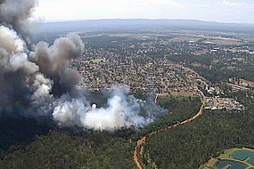
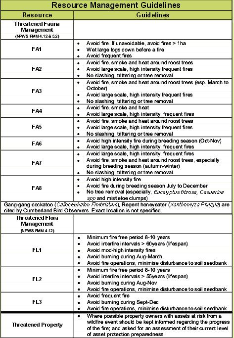
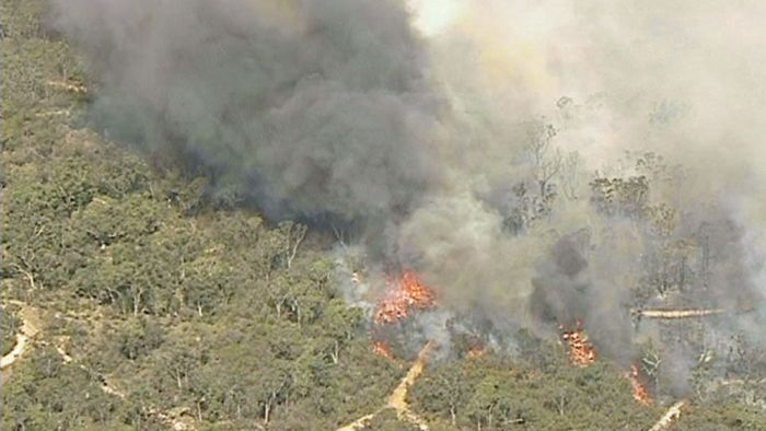 Windsor Downs Nature Reserve ablaze Windsor Downs Nature Reserve ablaze
Mis-identified by media as the ‘Marsden Park Fire’ ..”which started burning in a tip..”
[Source: Two Homes under threat in Sydney grass fire‘, 20130910, Australian Broadcasting Corporation,
^http://www.abc.net.au/news/2013-09-10/two-homes-under-threat-in-sydney-grass-fire/4948314]
.
Why did three wildfires start today in north western Sydney in protected reserves of Sydney’s remnant Cumberland Plains Woodland?
The fires all started around midday during high gusty wind conditions and unseasonally high temperatures. There was no lightning to speak of, so all three fires must have been caused by people.
Reckless burnoffs? Deliberately lit? By the same people? By developers wanting to undermine the Cumberland Plain Woodland and so extend their sprawl?
Whether it was bush arson or recklessness will be a matter for bushfire investigations which need to be mandatory for each and every wildfire. A forth wildfire at Winmalee in the nearby Blue Mountains (the ‘Hawkesbury Road Winmalee Fire‘) was purportedly a neglected hazard reduction burn – the Rural Fire Starters fuelling more work for themselves.
What did each wildfire cost – economic loss, infrastructure loss, productivity loss, direct firefighting costs, indirect costs, social costs? These are never measured or reported. The ecological costs are always ignored because ecology is not deemed to be valuable in our current society. How much death and harm has been infliced upon Windsor Downs Nature Reserve? Such value questions are beyond the thinking of our current society.
The RFS only prioritises saving human life and property. It thus has no different role than the NSW Fire Brigade. So the RFS should not exist. It only exists because the New South Wales government does not want to properly pay for firefighting. The RFS exists as unpaid volunteers so that the NSW government can divert hundreds of millions in taxes to other priorities it somehow considers to be more important.
Then the NSW government appeals for more volunteers to do its dirty work for free.
  . .
Whereas in New South Wales, a NSW Fire Brigage professional firefighter gets paid $29 an hour minimum. There will be many families that would dearly desire to receive that for their unpaid volunteering efforts.
.
“At Richmond Road and Bennett Road at Windsor, the RFS (New South Wales Rural Fire Service) says a grassfire could impact properties around George Street and the area of Bligh Park. The fire has crossed Garfield Road and is burning in the Windsor Downs Nature Reserve.”
[Sources: ‘Home lost as grass fires rage in Marsden Park and Windsor‘, 20130910, Daily Telegraph newspaper, Sydney, ^http://www.dailytelegraph.com.au/newslocal/the-hills/home-lost-as-grass-fires-rage-in-marsden-park-and-windsor/story-fngr8i1f-1226716140957; ‘Two Homes under threat in Sydney grass fire‘, 20130910, Australian Broadcasting Corporation, ^http://www.abc.net.au/news/2013-09-10/two-homes-under-threat-in-sydney-grass-fire/4948314]
.
The fire authorities have labelled this current fire the ‘Richmond Road Grass Fire‘, so will the records of the fire will be just scattered or erased? Today’s initial account of the fire on the official Rural Fire Service website reads thus :
“..A grass fire burning in the area of Richmond Road and Bennett Road at Windsor”. The fire is burning on both sides of George Street, South Windsor and both sides of Richmond Road. The fire is burning under strong northerly winds. An Emergency Alert telephone message has been sent to residents in these areas.
There is the potential for the fire to impact on properties around George Street and the area of Bligh Park. The fire has crossed Richmond Road and is now burning in the Windsor Downs Nature Reserve.”
.
To put this into geographic perspective, this is a presumed map of the affected area, in absence of RFS public transparency:
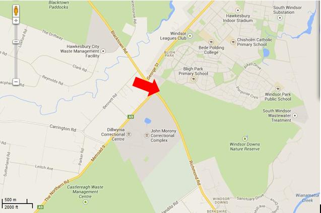
The presumed ignition of the Richmond Road Grass Fire
from Bennett Road, Windsor Downs
(outer north-western Sydney Metropolis)
[Source: Google Maps 2013]
.
<<Emergency warnings have now been issued for four bushfires in Sydney’s far north west, as temperatures in the city exceed 30 degrees with strong northerly winds.
The RFS says five firefighters have sustained smoke inhalation and two have received minor burns.
The fires are at Castlereagh, Richmond, Marsden Park, and Winmalee where one property is alight. At Richmond Road and Bennett Road at Windsor, RFS says a grassfire could impact properties around George Street and the area of Bligh Park. The fire has crossed Garfield Road and is burning in the Windsor Downs Nature Reserve. >>
.
[Ed: Garfield Road is in Riverstone, not Richmond, and is also quite distinct from the separate fire at Windsor Downs. Media reporting has been misleadingly false, overlapping and confused and likely due to naive junior desktop journalism. Worse is that the RFS report is equally confused. Fortunately no person died relying upon officialdom, but the wildlife count is never published].
.
.
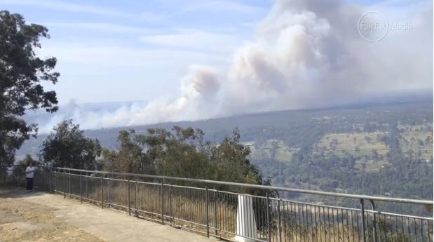
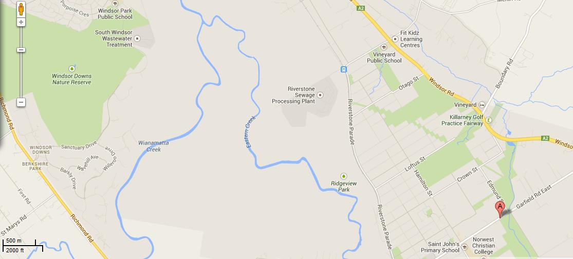 Map showing the juxtaposition of the Windsor Downs Nature Reserve over 3 km north west from Garfield Road in Riverstone.
Journalists have a lot to answer for when it comes to fact checking during emergencies.
[Source: Google Maps 2013, click image to enlarge]
Map showing the juxtaposition of the Windsor Downs Nature Reserve over 3 km north west from Garfield Road in Riverstone.
Journalists have a lot to answer for when it comes to fact checking during emergencies.
[Source: Google Maps 2013, click image to enlarge]
.
<< About 3,200 homes in the Richmond area have lost power and Endeavour Energy says it is working to get the supply back. The RFS says the fire is burning intensely under strong winds.
In Marsden Park, a grass fire is burning out of control and has crossed Garfield Road. While at Castlereagh, near Penrith, an emergency warning was issued around noon (AEST) for a fire which has destroyed a shed and burned 60 hectares. About 50 homes are thought to be under threat. The fire is burning around properties on Devlin Road and is moving towards homes on Nutt Road.
RFS Inspector Ben Shepherd says the conditions are difficult for firefighters.
RFS Inspector Ben Shepherd:
“I’m currently sitting on Nutt Road and the fire is moving quickly towards some homes in that area. The actual fire itself is putting up a huge column of smoke… and the wind continues to be quite strong. Because of that, that’s starting to send a couple of spot fires ahead of the main fire front itself.”
.
Local resident Kelly Elson has been evacuated from her home near the fire front. She says she first noticed the fire at about 10:30 this morning.
Windsor resident Troy Evans says that fire started in grass near his house on Bennett Road.
Windsor resident Troy Evans:
“So I went and told the firies ‘you better get a couple of trucks round here real quick’ which they did, luckily. They got the place under control then the wind turned and it’s just roared up through next door, jumped the road, it’s gone through the church, it’s over in the bus bay, it’s meant to have taken a couple of houses out in Bligh Park. Now it’s on it’s way into the jail, it’s just crazy.”
.
A very high fire danger alert has been issued for the Illawarra, Sydney, the Central Ranges, the Hunter, the north west and the north coast. More than 40 uncontained bushfires are currently burning across New South Wales.
Mr (RFS Commissioner Shane) Fitzsimmons says it is hot, dry and windy in most of the state today, with seven districts in very high fire danger. He says he is worried about the unseasonally warm start to spring on the back of a dry winter.
The RFS is urging property owners in semi-rural and rural areas to think about the conditions before they burn off land.”
.
[Ed: Fitzsimmons, why blame the weather and not the landholder who is accused of causing the ignition?]
.
[Source: ‘Homes under threat from bushfires at Castlereagh and Windsor in Sydney’s far north west’, 20130910, Australian Broadcasting Corporation, ^http://www.abc.net.au/news/2013-09-10/two-homes-under-threat-in-sydney-grass-fire/4948314]
.
[Ed: So the RFS is urging property owners in semi-rural and rural areas to think about the conditions before they burn off land.
Is this head office code for the known landholder who caused the fire and the RFS being too public servant skin timid to lay charges? So why is the landholder in Bennett Road not under arrest for suspected arson?]
.
The fire inside the Windsor Downs Nature Reserve today
.
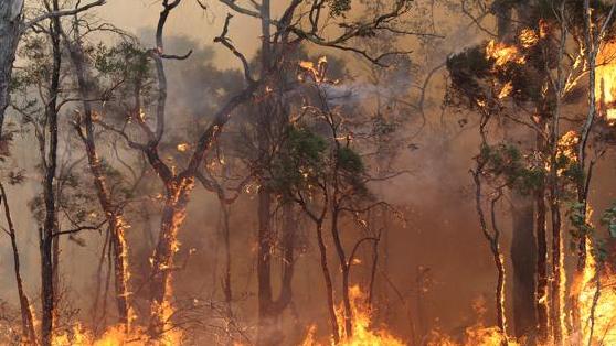 Windsor Downs native woodland habitat being burned alive
[Source: ‘Bushfires threaten Sydney’s western suburbs – NSW Rural Fire Service issues emergency warnings’, 20130910, Sydney Morning Herald newspaper (Sydney), ^http://www.smh.com.au/environment/bushfires-threaten-sydneys-western-suburbs-nsw-rural-fire-service-issues-emergency-warnings-20130910-2thnl.html] Windsor Downs native woodland habitat being burned alive
[Source: ‘Bushfires threaten Sydney’s western suburbs – NSW Rural Fire Service issues emergency warnings’, 20130910, Sydney Morning Herald newspaper (Sydney), ^http://www.smh.com.au/environment/bushfires-threaten-sydneys-western-suburbs-nsw-rural-fire-service-issues-emergency-warnings-20130910-2thnl.html]
.
.
 A liar bird of disinterested political masters A liar bird of disinterested political masters
.
http://www.youtube.com/watch?v=VktLOr4M46U
.
Cumberland Plain Woodland
.
Cumberland Plain Woodland including the Windsor Downs Nature Reserve, the nearby Castlereagh Nature Reserve and Agnes Banks Nature Reserve, all fall under the custodial management responsibility of the National Parks and Wildlife Service New South Wales – a state body.
Windsor Downs Nature Reserve features.. << an historic windmill and water tank protects a number of endangered plant communities and includes species such as the broad-leafed ironbark, grey box, scribbly gum, narrow-leafed angophora, pea flowers and a species of geebung.
Several bird species have been recorded – the red-capped and hooded robins, white-winged choughs, buff-rumped and yellow-tailed thornbills and the endangered regent honeyeater – which are usually found in the drier habitats of the central west slopes. >>
[Source: NSW Government, ^ http://www.environment.nsw.gov.au/NationalParks/parkHome.aspx?id=N0598]
.
Windsor Downs Nature Reserve is not just set aside for picnics. It is a remant ecological community with the fast disappearing Cumberland Plain Woodland. It is supposed to be protected.
.
<< The Cumberland Plain Woodland is the name for the distinct groupings of plants that occur on the clay soils derived from shale on the undulating Cumberland Plain in central New South Wales. The most commonly found trees in the woodland are Grey Box Eucalypts Eucalyptus moluccana, Forest Red Gums Eucalyptus tereticornis, Narrow-Leaved Ironbarks Eucalyptus crebra and Spotted Gum Eucalyptus maculata. A variety of other lesser-known eucalypts as well as shrubs, grasses and herbs are also found. It is the dominance of Grey Box and Forest Red Gum that makes the community distinctive.
In 1877 Cumberland Plain Woodland covered 107,000 hectares occupying approximately 30 per cent of the Sydney Basin. This community type was once widespread in the Plains but has been reduced to a few fragmented stands by human use for farming, industry and housing. Today less than six per cent remains in small fragments scattered across the western suburbs of Sydney, totalling only 6400 hectares. The remaining fragments occur in areas subject to intense pressure from urban development.
Although some areas occur within conservation reserves, this is in itself not sufficient to ensure the long-term survival of the community unless the factors threatening the integrity and survival of the community are eliminated.
The remaining stands of this ecological community are threatened by the spread of the Sydney suburban areas. Threats include clearance for agriculture, grazing, hobby and poultry farming, housing and other developments, invasion by exotic plants and increased nutrient loads due to fertiliser run-off from gardens and farmland, dumped refuse or sewer discharge.>>
[Ed: and of course ‘bushfire’, which the government does not like to include out of embarassment of neglect, yet which is causes the most devastating impact].
.
[Source: ‘Woodlands vanishing from Sydney’s outskirts’, by Environment Australia, Australian Government, ^http://www.environment.gov.au/biodiversity/threatened/publications/cumberland.html]
.
Cumberland Plain Woodland in the Sydney Basin Bioregion – proposed critically endangered ecological community listing
.
<< The NSW Scientific Committee, established by the Threatened Species Conservation Act, has made a Preliminary Determination to support a proposal to list the Cumberland Plain Woodland in the Sydney Basin Bioregion as a CRITICALLY ENDANGERED ECOLOGICAL COMMUNITY on Part 2 of Schedule 1A of the Act and as a consequence, to omit reference to Cumberland Plain Woodland from Part 3 of Schedule 1 (Endangered Ecological Communities) of the Act. The listing of Critically Endangered Ecological Communities is provided for by Part 2 of the Act.
The Scientific Committee has found that:
1. Cumberland Plain Woodland was listed as an Endangered Ecological Community under the Threatened Species Conservation Act 1995 in June 1997 (NSW Scientific Committee 1997). Since this listing, a large volume of new data and analyses have become available. In addition, a nomination to change the status of Cumberland Woodland to Critically Endangered status has been received. This Determination addresses additional information now available in accordance with current listing criteria under the Threatened Species Conservation Regulation 2002.
2. Cumberland Plain Woodland is the name given to the ecological community in the Sydney Basin bioregion associated with clay soils derived from Wianamatta Group geology, or more rarely alluvial substrates, on the Cumberland Plain, a rainshadow area to the west of Sydney’s Central Business District. >>
<<..high frequencies of fires may result where fragmentation increases the interface between urban areas and bushland, as this results in increased arson, car dumping, planned fuel-reduction fires and accidental ignitions.
High fire frequencies are associated with reduced diversity of native plant species in Cumberland Plain Woodland (Watson 2005). ‘High frequency fire resulting in disruption of life cycle processes in plants and animals and loss of vegetation structure and composition’ is listed as a Key Threatening Process under the Threatened Species Conservation Act 1995.
The season of fire, which may be altered as a consequence of hazard reduction fires, may also influence the species composition of the grassy woodland understorey (Knox & Clarke 2006; Benson & von Richter 2008).
Disruption of ecological processes associated with alteration of fire regimes contributes to a very large reduction in ecological function of the community. >>
.
[Source: ‘NSW Scientific Committee – preliminary determination’, Australian Government, ^http://www.environment.nsw.gov.au/determinations/cumberlandplainpd.htm]
.
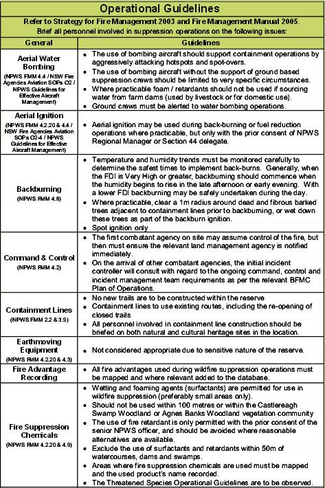
But wait, there is a:
which reads…

.
The official Fire Management Strategy has been conveniently removed from public access on the National Parks and Wildlife Service (NPWS) website.
However, the following extracts from the similar and nearby Agnes Banks Nature Reserve are instructive as to the approach taken by NPWS management on all nature reserves across the Sydney Basin that comprise remnant ecology of the Cumberland Plain Woodland.
.
.
Source: ‘Agnes Banks Nature Reserve Fire Management Strategy, 2006, (last modified 20070323), NPWS (NSW), NSW Government, ^http://www.environment.nsw.gov.au/resources/parks/06354AgnesBanksFMS.pdf]
.
[Ed: Disturbingly noted is that the NPWS ‘ecological’ policy is that it ok to burn these woodland reserves every 8 years. So government care factor about bushfire impact?]
.
<<..little research has been undertaken into fire management prescriptions for Cumberland Plain woodland and forest associations when compared to the nearby Hawkesbury sandstone communities.>>
~ Windsor Downs Nature Reserve et al. Plan of Management (NPWS 1999,p.18)
.
The official Bureau of Meteorology had in the days prior, forecast strong gusty north westerly winds for the western Sydney region for both yesterday and today, following a few days of calm winds. The Rural Fire Service would have been well aware of this forecast, the extreme bushfire conditions that this posed and the considerable escalated risk of damaging wildlfires.
The subsequent actual weather observations for Richmond are telling. Look at the 10th. The arsonists know what they are doing.
.
 [Source: Australian Bureau of Meteorology,
^http://www.bom.gov.au/climate/dwo/201309/html/IDCJDW2119.201309.shtml] [Source: Australian Bureau of Meteorology,
^http://www.bom.gov.au/climate/dwo/201309/html/IDCJDW2119.201309.shtml]
.
Reliant mainly on public calls to ‘000’, fire trucks and road-routed volunteers, the RFS continues to be grossly under-equipped to handle wildlfires in a timely and effective manner, which increasingly to many is unacceptable to bushfire prone communities in this now 21st Century.
.
 Windsor Downs Nature Reserve ablaze (from Hawkesbury Lookout) Windsor Downs Nature Reserve ablaze (from Hawkesbury Lookout)
[Source: ‘Hazard reduction burn started major Sydney bushfire’, by Megan Levy, Sydney Morning Herald, 20130913,
^http://www.smh.com.au/nsw/hazard-reduction-burn-started-major-sydney-bushfire-20130913-2tois.html]
.
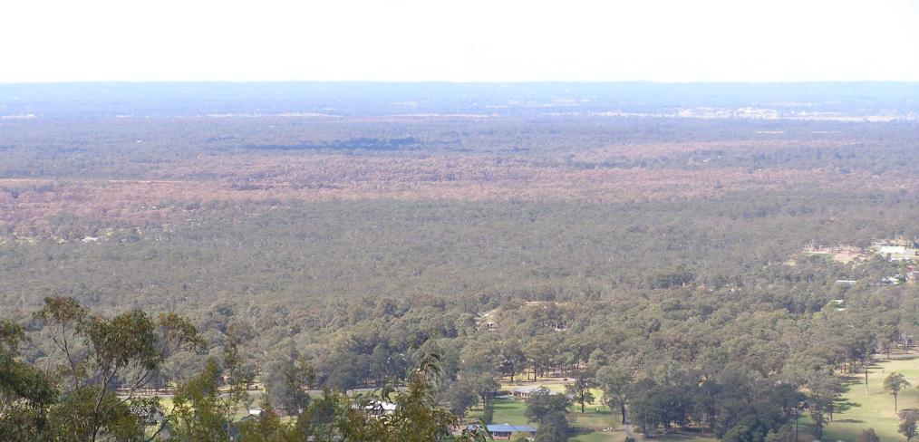 Windsor Downs Nature Reserve incinerated (see browned woodland canopy in centre of photograph)
[Photo taken by Editor from Hawkesbury Lookout looking north east on 20130921, photo © under ^Creative Commons]
Click image to enlarge Windsor Downs Nature Reserve incinerated (see browned woodland canopy in centre of photograph)
[Photo taken by Editor from Hawkesbury Lookout looking north east on 20130921, photo © under ^Creative Commons]
Click image to enlarge
.
Steadily year on year, the last bushland reserves that provide critical remnant habitat around Sydney are being destroyed. Before long the only bushland will be that in suburban gardens, and the wildlife will be finally made regionally extinct.
.
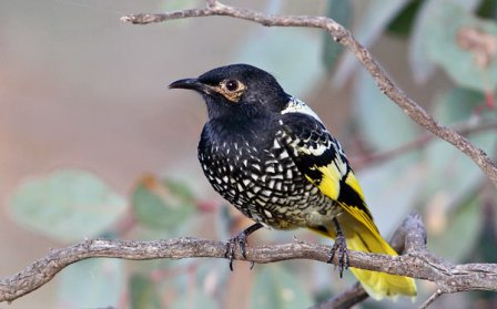 Critically Endangered Regent Honeyeater
(Anthochaera phrygia)
A native bird species dependant upon a disappearing habitat
Humans obliterated its habitat for logging, farming and housing
Then we constrained it to a few nature reserves like Windsor Downs,
Then we burnt the reserve. Critically Endangered Regent Honeyeater
(Anthochaera phrygia)
A native bird species dependant upon a disappearing habitat
Humans obliterated its habitat for logging, farming and housing
Then we constrained it to a few nature reserves like Windsor Downs,
Then we burnt the reserve.
.
.
.
Further Reading:
.
[1] ‘NSW Scientific Committee – preliminary determination‘, Australian Government, ^http://www.environment.nsw.gov.au/determinations/cumberlandplainpd.htm
.
[2] ‘Castlereagh, Agnes Banks and Windsor Downs Nature Reserves – Plan of Management‘, NSW Government, ^http://www.environment.nsw.gov.au/resources/parks/pomfinalagnescastlereagh.pdf
.
Footnote
.
‘Hunt for arsonist over western Sydney bushfire’
[Source: ‘Hunt for arsonist over western Sydney bushfire’, Friday 20130913, ABC, ^http://www.abc.net.au/news/2013-09-13/hunt-for-arsonist-over-western-sydney-bushfire/4956022]
.
<<Authorities say they believe a fire that destroyed a home at Marsden Park in Sydney’s west on Tuesday was deliberately lit. Investigators have also not ruled out that an arsonist may have caused a blaze at nearby Londonderry. Police are now calling for witnesses to help identify the person responsible for sparking the Marsden Park fire.
Assistant Commissioner Alan Clarke says it is believed the fire began on Grange Avenue just after midday on Tuesday.
.
Alan Clarke:
.
“There are crime scene indicators at the source of that fire that would lead us to suspect arson activity. I really can’t tell you more than that at the moment. It’s mainly our crime scene indicators and forensic evidence that would have us raise that suspicion. If anyone has information, if anyone saw any suspicious activity in or around that fire location, any part of it… please pass that information on for the benefit of police.”
.
Rural Fire Service Deputy Commissioner Rob Rogers has confirmed another serious fire at Winmalee, in the lower Blue Mountains, was caused by a hazard reduction burn conducted by the NSW National Parks and Wildlife Service.
.
Rob Rogers:
“That fire was burn on the weekend, it was patrolled on Monday, there was smouldering activity. That fire then jumped containment lines on the Tuesday and became an active fire. The winds on that day did exceed forecast and they were around 90 kilometres an hour, and obviously that tested the control lines on that hazard reduction and it did escape. In these strong winds branches came off trees, hit the powerlines, the powerlines were brought down, they ignited grass in that area and that was the cause of that fire. You would have to obviously be suspicious that it did come from the hazard reduction, given that it was in a very close proximity to it.”
.
Investigators have found a fourth fire that began on Richmond Road at Windsor Downs was sparked by downed power lines. The investigation into a fire that closed the M1 motorway, formerly known as the F3, north of Sydney yesterday is continuing, with another hazard reduction burn the suspected cause. Assistant Commissioner Alan Clarke has warned those that deliberately light fires or cause them through negligence will be caught.
.
Alan Clarke:
“Last year we arrested 87 individuals and they faced charges in respect of bushfire and fire related activity for 117 charges. We know this year again we will be putting offenders before the court. It’s sad but it’s true.”
.
Tags: A liar bird of disinterested political masters, Agnes Banks Nature Reserve, Castlereagh Nature Reserve, Cumberland Plain Woodland, Hawkesbury Road Winmalee Fire, Marsden Park Fire, NPWS, NSW Fire Brigade, NSW National Parks and Wildlife Service, Retained Firefighter, Richmond Road Grass Fire, Rural Fire Starters, Windsor Downs Nature Reserve
Posted in Birds (Australian), Critically Endangered Wildlife (CR), Threats from Bushfire | No Comments »
Add this post to Del.icio.us - Digg
Saturday, June 22nd, 2013
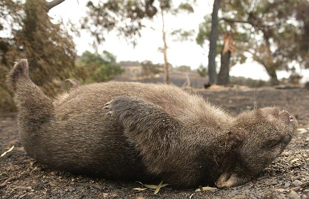
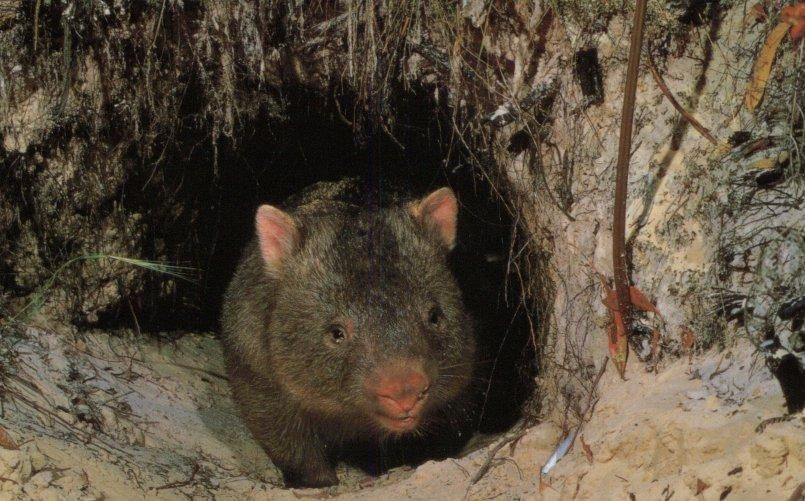
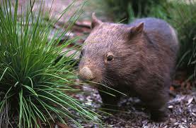
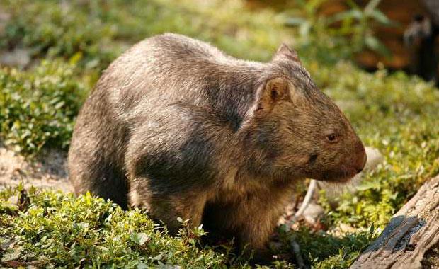 Common Wombat
(Vombatus ursinus)
A legally protected native animal throughout Australia
[Source: Healesville Sanctuary, Victoria, Zoos Victoria,
^http://www.zoo.org.au/healesville/animals/wombat] Common Wombat
(Vombatus ursinus)
A legally protected native animal throughout Australia
[Source: Healesville Sanctuary, Victoria, Zoos Victoria,
^http://www.zoo.org.au/healesville/animals/wombat]
.
June 2013:
.
Tragically, a native Wombat has been deliberately poisoned this month in Mount Wilson in the Blue Mountains, and so the New South Wales National Parks and Wildlife Service (NPWS) is appealing for information from the local community.
Ranger Neil Stone of the NPWS Blue Mountains Region:
“A Wombat was recently found at Mount Wilson village (population 220), suffering from what a local veterinarian thinks was poisoning and sadly the animal had to be euthanized.
“Wombats become unpopular with landholders when they damage fences and infrastructure or trample on gardens. But there are methods, including installing Wombat Gates, that enable Wombats to pass through properties without damaging them.”
.
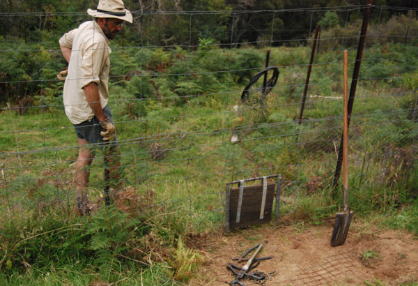 An example of a purpose-built Wombat Gate
If one can afford property at exclusive Mount Wilson with average prices currently $750,000 [^Source]
then one can afford to contribute a few purpose-built Wombat Gates across their property,
constructed by wildlife experts who know what they are doing!
[Photo Source: Rocklily Wildlife Refuge, Taralga, NSW,
^ http://rocklilywombats.com/blog/rocklily-history/] An example of a purpose-built Wombat Gate
If one can afford property at exclusive Mount Wilson with average prices currently $750,000 [^Source]
then one can afford to contribute a few purpose-built Wombat Gates across their property,
constructed by wildlife experts who know what they are doing!
[Photo Source: Rocklily Wildlife Refuge, Taralga, NSW,
^ http://rocklilywombats.com/blog/rocklily-history/]
.
NPWS Ranger Neil Stone:
“Wombats are extremely strong and determined, constructing their burrows (often under homes) to escape from the heat and to hide from predators (typically domestic and feral dogs nowadays). The burrows can be up to 30 metres long which can cause conflict between Wombats and humans.”
“Wombats and all other native animals are protected under the National Parks and Wildlife Act 1974 and Regulations and it is illegal to harm them without a licence. There are fines and possible imprisonment for people found to have intentionally harmed native wildlife.”
.
[Source: ‘Not so divine: Wombat dies in suspected poisoning’, 20130612, Blue Mountains Gazette newspaper (print only), p.15]
.
Wildlife Poisoning is Animal Harm
.
Wombats being mammals are sentient animals, meaning that they feel emotion and pain. An animal is ‘sentient‘ if it is capable of being aware of its surroundings, its relationships with other animals and humans, and of sensations in its own body, including pain, hunger, heat or cold.
Individuals who harm animals including the harming of wildlife such as by poisoning, tend to harbour a personality disorder. Statistically, animal abusers are five times more likely to go on to commit violent crimes against people.
Deviant behaviors like animal abuse generally originate from a traumatic childhood. The American Psychiatric Association considers animal cruelty as one of the diagnostic criteria of conduct disorder.
The fourth edition of the Diagnostic and Statistical Manual of Mental Disorders (DSM) defines conduct disorder as “a repetitive and persistent pattern of behavior in which the basic rights of others or major age appropriate societal norms or rules are violated.” Conduct disorder is found in those who abuse animals and abuse people.
Clinical evidence indicates that animal cruelty is one of the symptoms usually seen at the earliest stages of conduct disorder, often by the age of eight. This information has only recently been included in the DSM so some psychologists, psychiatrists, and social workers are just now becoming aware of it. Many psychological, sociological and criminology studies in recent decades have clearly shown that violent offenders have adolescent histories of serious and repeated animal cruelty.
Director of People for the Ethical Treatment of Animals (PETA) Asia, Jason Baker, has said, “We believe that cruelty to animals is not inherent, but learned. That being said, teaching kindness and respect for animals – in our schools and homes – will foster empathy, the ability to understand what someone else feels.” He added, “Incorporating the simple concepts of kindness and respect into our daily lives and teaching our children to respect and protect even the smallest and most despised among us will help kids value one another.”
The link between animal abuse and interpersonal violence is becoming so well established that many U.S. communities now cross-train social-service and animal-control agencies in how to recognize signs of animal abuse as possible indicators of other abusive behaviors. >>
.
[Source: ‘Animal Cruelty Syndrome’, by Canadians for Animal Welfare Reform, ^http://cfawr.org/animal-abuse.php]
.
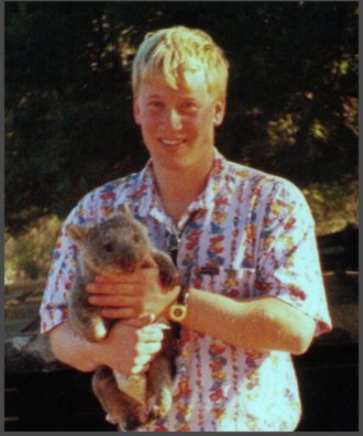 Martin Bryant as a teenager nursing a juvenile Wombat
Bryant reportedly tortured animals as a child.
In 1996, at age 29 Bryant murdered 35 people and injured 21 others
at Port Arthur Tasmania Martin Bryant as a teenager nursing a juvenile Wombat
Bryant reportedly tortured animals as a child.
In 1996, at age 29 Bryant murdered 35 people and injured 21 others
at Port Arthur Tasmania
.
Penalties in NSW for Harming protected Fauna
.
.
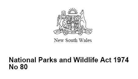
Sect 98 ‘Harming protected fauna, other than threatened species, endangered populations or endangered ecological communities’
.
(Ed: i.e. Wombats)
.
(1) In this section, protected fauna does not include threatened interstate fauna, threatened species, endangered populations, endangered ecological communities, or locally unprotected fauna under section 96.
(2) A person shall not:
(a) harm any protected fauna, or (a1) harm for sporting or recreational purposes game birds that are locally unprotected fauna, or
(b) use any substance, animal, firearm, explosive, net, trap, hunting device or instrument or means whatever for the purpose of harming any protected fauna.
.
Maximum penalty:
.
(a) 100 penalty units and, in a case where protected fauna is harmed an additional 10 penalty units in respect of each animal that is harmed, or
(b) imprisonment for 6 months, or both. >>
.
Note: As at 2013, 1 penalty unit in NSW equates to $110. So 100 +10 penalty units incurs a fine of $12,100 per protected Wombat harmed [Calculation: (100 + 10) x $110]
.
[Sources: National Parks and Wildlife Act 1974, No 80, Section 98, (historical version but this section still current), pp 149-150, ^http://www.environment.nsw.gov.au/legislation/NationalParksAndWildlifeAct1974.htm ; ^http://en.wikipedia.org/wiki/Penalty_units]
.
.
.
So who killed the Mt Wilson Wombat?
.
 A common Wombat sight
…”Just Roadkill”
A common Wombat sight
…”Just Roadkill”
.
It is likely that Mount Wilson’s Wombat was poisoned by an ignorant and frustrated local landholder. He is one of just a few hundred residents living at remote Mount Wilson village, and probably he is some arrogant newcomer with no respect for the natural environment or its resident wildlife who were there first. It is extremely rare for a female to commit wildlife poisoning.
The perpetrator is likely to be someone holding an Anglicised mindset toward rural property, desiring the exotic deciduous garden and with a phobia towards the natural Australian bush. Whereas the more established residents tend to be respectful towards the special environment in which they live and have become more accommodating towards the place’s resident wildlife.
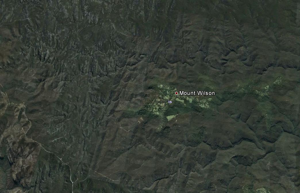 Mount Wilson lies in a remote forested wilderness region of the Blue Mountains
And the native Wombats have lived there thousands of years before
Colonial Deforestation
Housing Development
Anglicised Garden Romanticism
[Source: Google Earth]
(click image to enlarge) Mount Wilson lies in a remote forested wilderness region of the Blue Mountains
And the native Wombats have lived there thousands of years before
Colonial Deforestation
Housing Development
Anglicised Garden Romanticism
[Source: Google Earth]
(click image to enlarge)
.
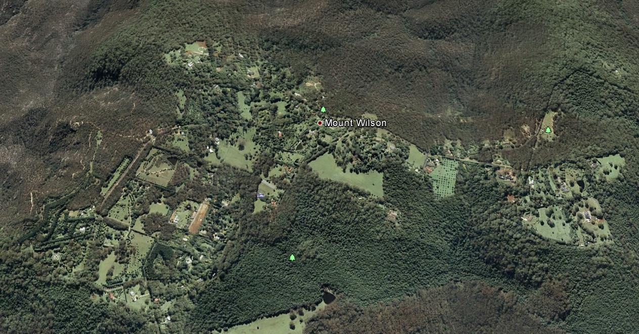 Mount Wilson
Best described as a remote hilltop residential hamlet
Situated on an ancient volcanic hill
Since the 1870s, logged, burned and settled by English colonists
amongst the ‘Wombat Holes’
[Source: Google Earth]
(click image to enlarge)
Mount Wilson
Best described as a remote hilltop residential hamlet
Situated on an ancient volcanic hill
Since the 1870s, logged, burned and settled by English colonists
amongst the ‘Wombat Holes’
[Source: Google Earth]
(click image to enlarge)
.
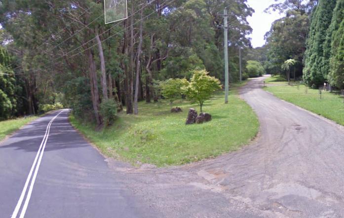 Hillcrest Lane (right), Mount Wilson Hillcrest Lane (right), Mount Wilson
[Source: Google Maps, 2013]
.
 Mount Wilson before the Anglicising
[Source: Mt Wilson/Mt Irvine Historical Society, ^http://www.mtwilson.com.au/]
Mount Wilson before the Anglicising
[Source: Mt Wilson/Mt Irvine Historical Society, ^http://www.mtwilson.com.au/]
.
Consistent with the profile of the typical member of the Game Council NSW, the perpetrator is likely to be a middle-aged or older male Babyboomer approaching 65, having an anthropocentric worldview of Nature, and an evangelistic belief that economic growth and personal wealth accumulation is a right – Wombats being collateral damage in rural housing development.
 Mount Wilson bushland
.
The perpetrator has not yet been confirmed, and anyone with information about this harmful offence is asked to contact the closest NPWS base at the Blue Mountains Heritage Centre in nearby Blackheath.
.
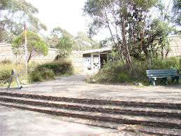 NPWS Blue Mountains Heritage Centre
Located towards the eastern end of Govetts Leap Road
outside the nearby township of Blackheath NPWS Blue Mountains Heritage Centre
Located towards the eastern end of Govetts Leap Road
outside the nearby township of Blackheath
.
.
.
The ‘Common‘ Wombat?
.
The Common Wombat (Vombatus ursinus) is also known as the Coarse-Haired Wombat or Bare-Nosed Wombat. In the case of the Bare-Nosed Wombat, this reference to its nose, distinguishes it from its other two subspecies, the Southern Hairy-Nosed Wombat (Lasiorhinus latifrons) and the endangered Northern Hairy-Nosed Wombat (Lasiorhinus krefftii).
The ‘Common Wombat‘ is a nocturnal marsupial native to south eastern Australia and is found in small sections of southeast tip of Queensland, eastern New South Wales, eastern and southern Victoria, and south-east South Australia. They are common throughout Tasmania and also on Flinders Island in Bass Strait.

The head of the Common Wombat is more rounded than that of the hairy-nosed subspecies. Their short ears are triangular and slightly rounded. Their nose is large, shiny black and furless. Their fur is coarser, thicker and longer than that of the Hairy-nosed Wombats, better suited to a colder, wetter habitat. Fur colour varies from sandy to brownish black or even grey, sometimes flecked.
.
 Bare-Nosed Wombat
a more respectful naming than ‘Common’ Bare-Nosed Wombat
a more respectful naming than ‘Common’
.
Wombats have short legs, and the second and third toes of the hind feet are fused, with a double claw used in grooming. Wombats are solid and stocky, with short legs and tail. Their front legs and shoulders are powerful. Their front feet are large, with bear-like long claws. They use their front legs for digging burrows. The dirt is pushed to one side and the Wombat backs out, moving loose dirt with front or back paws. It grows to an average of 98 cm long and up to a healthy weight of 26 kg.
Wombats are stilll classed as ‘least concern’ by the International Union for Conservation of Nature and Natural Resources (on the IUCN ‘red list’). [Ed: So were the Koala and Tasmanian Devil until recently].
At Healesville Sanctuary in Victoria, more than 2,000 sick and injured native animals treated each year including Wombats at its Australian Wildlife Health Centre.
[Source: Healesville Sanctuary, Zoos Victoria, Victorian State Government, ^http://www.zoo.org.au/healesville/animals/wombat]
.
 Situated on Badgers Creek
A place of inspiration to this Editor,
when visited as a child. Situated on Badgers Creek
A place of inspiration to this Editor,
when visited as a child.
.
Although Wombats have been named by European Australians as the ‘Common Wombat‘, their numbers and their existence value does not translate to anyone treating them as commonplace.
Common Wombats were once widespread from south-eastern Queensland, through NSW along the Great Dividing Range and most of Victoria. Now they have a fragmented distribution in NSW, being most abundant in the south-eastern parts of the state. Remaining populations are under continued pressure from land clearing, road mortality, disease and illegal shooting. These pressures may be acute for some local populations.
While the word ‘Wombat’ is derived from the Aboriginal name for the animal, ‘common’ was added at a time when these animals were plentiful and the Australian bush landscape relatively less destroyed by colonial settlement. Wombats were likened to European Badgers by the early colonists.
We prefer the more respectful name, ‘Bare-Nosed Wombat‘.
.
In 2010, university student Nikki Selles, from the School of Natural Sciences at the University of Western Sydney, undertook a field fauna study on Wombats in the Mt Wilson and Mt Irvine area. Due to the behaviour of slow moving, ground-dwelling Wombats being sensibly shy and noctural, Selles used camera-trap data to identify their habitat and distribution in the urban-bush interface.
Results ought to be obtainable from the university.
[Source: Mount Wilson and Community Newsletter, May 2010, ^http://www.mtwilson.com.au/images/stories/MWPA_Newsletters/May_2010.pdf]
.
While the Bare-Nosed Wombat is not yet threatened with extinction, the Northern Hairy-Nosed Wombat is endangered. This is mainly due to overgrazing by sheep and cattle destorying their fragile semi-arid habitat across more central Australia, as well as the culture of broadscale hazard reduction and uncontrolled bushfires.
Mount Wilson also provides vital native habitat for fauna species that are recognised as endangered. These include the Sooty Owl (Tyto tenebricosa), the Eastern Bent Wing Bat (Miniopterus schreibersii oceanensis), the Large eared pied bat (Chalinolobus dwyeri), Little John’s Tree Frog (Litoria littlejohni), and the Eastern False Pipistrelle (Falsistrellus tasmaniensis).
.
Living with Resident Wombats
.
 Wombats are locally territorial, like Humans
Try to relocate them, and they will stubbornly resist – even after repeated flood, drought, bushfire and earthquake
Ask any Human who has endured such tempest. Wombats are locally territorial, like Humans
Try to relocate them, and they will stubbornly resist – even after repeated flood, drought, bushfire and earthquake
Ask any Human who has endured such tempest.
.
<<Wombats are an iconic part of the protected fauna of NSW. They are extremely strong and determined animals.
They can build their burrows under Human-introduced houses, driveways and cattle stock routes. This may cause Humans inconvenience and conflict between Wombats and non-Indigenous Humans.
.
But Newcomer Humans need to respect that Wombats were there first.
Who likes Invasion or Displacement?
.
Human-Wombat conflicts can be respectfully resolved and accommodated by wisdom – by learning about the behaviour of Wombats and understanding their habitat needs.
The Bare-Nosed Wombat is the species most frequently found in NSW. They prefer temperate forested areas of the coast, ranges and western slopes. Slopes above creeks and gullies are favoured sites for burrows and they like to feed in grassy clearings, including farm paddocks.
.
Wombat Habitat Needs
.
Wombats construct burrows to escape the heat and hide from predators. They prefer areas where it is easy for them to dig. The burrows can be up to 30 metres long and several metres deep and are usually situated above creeks and gullies and may have multiple entrances. Active burrows are often characterised by fresh cube-shaped droppings and scratch marks as well as freshly dug soil at the burrow entrance. Wombats will often build more than one burrow within their home range of 5 to 25 hectares.
Wombats are mostly solitary animals, but overlapping home ranges can occasionally result in a number of Wombats using the same burrow. Wombats are possessive about their particular feeding grounds and they will mark out these areas by leaving scent trails and droppings. These markings are prominently placed on rocks and logs around the boundaries. If an intruding Wombat encroaches on another’s territory it will be discouraged through a series of snorts and screeches and at times physical aggression.
Breeding occurs year-round with each female typically producing one young. In some areas, however, Wombats are seasonal breeders and may have dependent young in burrows from April to June. Young Wombats take up to 21 months to reach full independence and two years to become sexually mature.
.
Wombat Behaviour
.
Wombats become unpopular with landholders when they damage fences and infrastructure or trample upon gardens. Undetected burrows can be a hazard to livestock as they may trip or fall into burrows and injure themselves.
Many of the problems caused by Wombats can be resolved with some patience and innovation. Landholders willing to share their property with Wombats may find that there are simple solutions to most problems. For example, a post or small strand fence can be used to mark burrows in paddocks or driveways to keep stock away from burrow entrances.
Wombats use the same trails to get to and from their preferred feeding areas. Instead of going around an obstacle, such as a fence, a determined Wombat will try to go through, or under it instead. Installing purpose-built ‘Wombat Gates’ at known Wombat breech points along a fence will allow them to pass through a fence without damaging it. The fence needs to continue to exclude other animals such as wallabies, rabbits and foxes.
Removing the lowest fencing wire (15 cm above ground level) will also allow Wombats to move through an area without damaging the fence. This is a much cheaper option than excluding them completely.
Check first with a Certified National Parks Wildlife Ranger.
.
Excluding wombats from Rural Property
.
It is possible to exclude Wombats from continuing to use a burrow that is under a building but this requires intervention by a Certified National Parks Wildlife Ranger.
.
Increasing Native Vegetation
.
Wombats prefer to burrow in areas of vegetation and rocky debris. Land clearing has forced Wombats to build burrows along creeks and drainage lines where vegetation still exists. Wombats are also often incorrectly blamed for causing erosion, which is more likely due to poor land management practices.
Planting trees and revegetating areas away from creeks can play a vital role in reducing Wombat burrowing activity along creek beds. Retaining existing trees, logs and rocks, and establishing new areas of native vegetation encourages Wombats to construct burrows in less fragile areas and reduces the risk of erosion.
Check first with a Certified National Parks Wildlife Ranger.
.
Trapping or Relocating Wombats Prohibited
.
The trapping and relocation of Wombats is prohibited and attracts heavy fines.
Wombats are territorial animals and if relocated, they are likely to be harassed or even killed by resident Wombats. Wombats are classified as protected fauna under the NSW National Parks and Wildlife Act 1974.
.
Can I bulldoze or infill a Wombat burrow?
.
No! Only inactive Wombat burrows may be destroyed, but each one needs to be first validated by a Certified National Parks Wildlife Ranger.
Bulldozing an active burrow can lead to wombats being buried alive and suffering a slow and painful death. Even if you have located an apparently vacant burrow, you must not fill it in without confirming that it is inactive. Burrow activity can be confirmed by placing sticks across each entrance and checking (every day for at least a week) if these are disturbed.
Remember that if you think you have an inactive burrow, check first with a Certified National Parks Wildlife Ranger.
contact your local National Parks office for expert verification before any action.
.
[Source: NSW Government, ^ http://www.environment.nsw.gov.au/animals/LivingWithWombats.htm#gate]
.
.
.
Further Reading
.
[1] Wombat Gate Design
^http://www.dpiw.tas.gov.au/inter.nsf/Attachments/LBUN-84H7FT/$FILE/Wombat%20gate%20design.pdf
.
[2] Guide to Living with Wombats
[Source: ^ http://www.naturalresources.sa.gov.au/samurraydarlingbasin/plants-animals/native-plants-and-animals/native-animals]
.
[3] National Parks and Wildlife Act (NSW) 1974
^http://www.austlii.edu.au/au/legis/nsw/consol_act/npawa1974247/
.
[4] Wombat Protection Society of Australia
^http://www.wombatprotection.org.au/
.
Why Do Wombats Need Protection?
Lack of Legislative Protection/Enforcement!
<< In Australia native animals are “the property of the Crown”. This means that no-one owns wombats, they can’t be kept as pets and to do anything with them you have to be licensed by government departments.
Government Departments do little to protect or help wombats. Most research and all welfare (rescuing injured wombats, raising the joeys of mothers killed in collisions with vehicles, removing wombats from unsuitable places) is undertaken by voluntary organizations. While penalties exist if someone is found to hurt or kill a wombat, the same government departments charged with wombat care issue permits to farmers to cull wombats. Sadly, there is often no check whether this is necessary, whether it is done humanely or any insistence that alternative options be employed before issuing such permits.
On the other hand although penalties exist for the illegal killing of wombats, such killing occurs every night where on a farms they are shot, buried alive and gassed and on the highways of Australia vehicles indiscriminately drive directly at wombats without penalty. Live joeys left in their dead mother’s pouches die slowly and a lack of public education means few Australians understand how to rescue a joey still living after its mother falls victim to road kill. >>
.
 The Crown
Disinterested in protecting Australian wildlife
The kangaroo and emu images are but token symbolism The Crown
Disinterested in protecting Australian wildlife
The kangaroo and emu images are but token symbolism
.
[5] The Wombat Foundation
^http://www.wombatfoundation.com.au/
.
<<The Wombat Foundation is a charitable organisation set up to support activities that aim to bring the Northern Hairy-nosed Wombat back from the brink of extinction.
The Northern Hairy-nosed Wombat is one of the world’s most endangered species – it is more endangered that the Panda.
In the 1980s, there were as few as 35 wombats remaining on the planet – all at Epping Forest National Park in central Queensland. A second population was established at Richard Underwood Nature Refuge in southern Queensland in 2009. At last count, in 2010, there were a total of 176 wombats across the two sites. Since then, the population has continued to grow: in 2012, the combined population at the two sites was estimated at 200 wombats. >>
.
[6] Wombat Awareness Organisation
^http://wombatawareness.com/
.
<<We are a charity established to help save the Southern Hairy-nosed Wombat (Lasiorhinus latifrons) from extinction.
The wombat is an Aussie icon but few people are aware of the peril these gorgeous little animals face: drought, floods, climate change, disease, vehicular incidents and culling – both legal and illegal. It’s not rocket science to see these animals are in trouble but thanks to the work of WAO volunteers, there is hope!
Currently, the wombats are being affected by an unidentified disease outbreak. The visual symptoms are hair loss and emaciation, internally the wombats are anemic and in some cases there is liver damage and heart disease. The direct cause is unknown however it is suspected that due to an increase in weeds there is a decrease in food availability therefore the wombats are forced to eat what they can most of which unfortunately is toxic. >>
.
[7] WIRES
NSW Wildlife Information, Rescue and Education Service Inc.
^http://www.wires.org.au/
.
[8] Rocklily Wildlife Refuge
Taralga, NSW, ^ http://rocklilywombats.com/blog/rocklily-history/
.
<<This website is about Rocklily Wildlife Refuge, and a few other wildlife carers we know in Australia too. Providing a safe place for our native flora and fauna and the various wildlife projects we are undertaking can be an expensive business, so we sell reasonably priced, quality Australian-made gifts and artisan products to raise money for our wildlife projects.
..This website has come about with our move to Rocklily Wildlife Refuge: a safe place for wild native animals just inside the SW border of the Greater Blue Mountains National Park, and within the locked gate of the Sydney Water Catchment. >>
.
[8] Healesville Sanctuary
^http://www.zoo.org.au/healesville
.
<<Healesville Sanctuary, or the Sir Colin MacKenzie Fauna Park, is a zoo specializing in native Australian animals. It is located at Healesville in rural Victoria, Australia (east of Melbourne), and has a rare history of successfully breeding Australia’s native animals.
.
[9] People for the Ethical Treatment of Animals (PETA)
^http://www.petafoundation.org/
.
[10] Voiceless, The Animal Protection Institute
Paddington, New South Wales
^https://www.voiceless.org.au/the-issues/animal-sentience
.
[11] The Cambridge Declaration on Consciousness
.
‘The Cambridge Declaration on Consciousness’, 20120707, by Philip Low, Paper presented at the Francis Crick Memorial Conference on Consciousness in Human and Non-Human Animals, Churchill College, University of Cambridge, England, ^http://fcmconference.org/img/CambridgeDeclarationOnConsciousness.pdf
<< In 2012, an international group of eminent neuroscientists signed The Cambridge Declaration on Consciousness, which confirmed that many animals, including all mammals and birds, possess the “neurological substrates that generate consciousness.” >>
.
.
[12] The Baby Boomers Who Destroyed the World
.
‘The Baby Boomers Who Destroyed the World’, 20110218, by Karlsie, in Subversify, ^http://subversify.com/2011/02/18/the-baby-boomers-who-destroyed-the-world/]
.
[13] Mount Wilson Property Prices
^http://reareports.realestate.com.au/house_prices_growth_rates/nsw/mount_wilson/2786
.

..
 . .
 . .
 . .
.
2013 Price?
.
Tags: Anglicising, animal cruelty, Animal Cruelty Syndrome, Animal Harm, Bare-Nosed Wombat, Blue Mountains, Coarse-Haired Wombat, Common Wombat, Living with Wombats, Martin Bryant, Mount Wilson, Mount Wilson Property, Mount Wilson Property Prices, Mount Wilson Real Estate, Mt Wilson, national parks and wildlife act, NSW National Parks and Wildlife Service, sentient, Wombat Gate, Wombat Habitat, wombat poisoned, Wombat Protection
Posted in Blue Mountains (AU), Threats from Development, Threats from Poaching and Poisoning, Wombats | 1 Comment »
Add this post to Del.icio.us - Digg
Monday, December 17th, 2012
 McIntyres Hut Bushfire in Brindabella National Park, New South Wales, 8th January 2003
It was manageable then, but negligently left to burn for days by the Rural Fire Service McIntyres Hut Bushfire in Brindabella National Park, New South Wales, 8th January 2003
It was manageable then, but negligently left to burn for days by the Rural Fire Service
.
On 8th January 2003, reported lightning strikes had ignited remote fires in the Brindabella National Park inside New South Wales and in Namadgi National Park in the Australian Capital Territory (ACT).
Ten days later, the McIntyres Hut Bushfire along with the Bendora Bushfire, the Stockyard Spur Bushfire and the Mount Gingera Bushfire, coalesced and burnt out of control into the south-western suburbs of Canberra.
It tragically became The 2003 Canberra Firestorm.
- Four people perished
- 435 people were injured, many suffering horrific burns
- 487 homes and 23 commercial and government premises were destroyed
- 215 homes, commercial premises, government premises and outbuildings were damaged
- Mount Stromlo observatory (an institution of international renown) was destroyed
- An inestimatable number of animals (livestock and wildlife) were killed
- Almost 70% of the ACT, some 157,170 hectares were burnt
.
 Canberra Firestorm looms
[Source: SOSNews.org, ^http://www.sosnews.org/newsfront/?p=236] Canberra Firestorm looms
[Source: SOSNews.org, ^http://www.sosnews.org/newsfront/?p=236]
.
The ACT Coroner Maria Doogan conducted an inquiry into the cause, origin and circumstances of the bushfires and inquests into the four deaths associated with those fires. On December 2006, her findings: ‘The Canberra Firestorm‘ concluded that “failure to aggressively attack the fires in the first few days after they ignited” was a key factor that led to the firestorm.
Coroner Doogan was also scathing of the ACT’s Emergency Services Bureau (ESB) for:
- Failing to attack the fires that had been burning for 10 days before they reached the capital.
- Failing to warn residents of the danger early enough, saying this exacerbated the property losses and caused panic and confusion on the day of the firestorm.
.
But responsibility for fire suppression inside the Brindabella National Park also lay with the NSW National Parks and Wildlife Service.
Today ACT Supreme Court Chief Justice Terence Higgins has found that the New South Wales Government (Rural Fire Service) was negligent in the way it tackled the January 2003 blaze.
One of the plaintiffs suing the NSW Government, Brindabella landowner Wayne West said today “We have won the case on negligence, the judge has made a decision the fire should have been fought and could have been fought in a different manner, and we win the case at common law.’’
Mr West, along with plaintiffs represented by insurance giant QBE Insurance, have been suing the NSW Government for gross negligence.
But the NSW Rural Fires Act 1997 confers immunity from liability if the Rural Fire Service acted “in good faith”. This means that even though the Rural Fire Service is guilty of gross negligence, it and its members are immune from prosecution for negligence, becase they can hide behind the NSW Rural Fires Act.
So Chief Justice Higgins has ruled in favour of the NSW Government.
“The result I have reached is that the plaintiffs’ claim must, as a matter of law, be denied,” Chief Justice Terence Higgins said today in an 86-page judgment.
“However, but for the express limitations on the liability which otherwise would attach at common law, those plaintiffs who suffered loss or damage would have been entitled to compensation for their losses. Effectively, they are deprived by statute of what would, under the general law, be regarded as just compensation.”
“The legislature has, however, spoken so as to exempt NSW from such liability, and the courts must apply the law as parliament has decreed it.”
The judge agreed with the plaintiffs that the NSW Rural Fire Service embraced an “inadequate and defective strategy. “The question is, however, whether the adoption of that strategy, albeit negligent, was ‘so unreasonable that no authority could properly consider the act of omission to be a reasonable exercise of its functions’.”
The judge identified failures in strategic planning, but made no criticism of the front-line firefighters “at any level”.
Mr West said while the ultimate decision was “devastating” the case was never about the money.
“That fire was allowed to burn, there could have been action taken to prevent the fire escaping or being enticed to escape. The fires shouldn’t have burnt the houses and [caused] the injuries and the four lives in Canberra, that’s what we were here for from day one.’’
When asked what lessons should be taken from the firefighting response Mr West replied:
.
“Get in the fire immediately and look at the fire – don’t look at it 50 kilometres away.”
 Bushfire Progress – click on image
(The top red patch is the McInture Bushfire inside NSW) Bushfire Progress – click on image
(The top red patch is the McInture Bushfire inside NSW)
.
Alan Conolly, representing the QBE clients, said they would read the judgment and consider their options.
“There’s always, in a case as big as this, there’ll be issues we have to look at, and at the moment we first have to read the judgment and advise our clients,” he said.
West has immediately flagged a decision to challenge this decision and to take that fight to the ACT Court of Appeal.
“We have only fallen over in the courtroom today on an Act the [NSW] government put in place…the state doesn’t have a duty of care to an individual, and that’s where we fell over today”, West said.
.
[Source: ‘West to appeal after losing 10-year court battle’, 20121217, by Louis Andrews (journalist), Canberra Times, ^http://www.canberratimes.com.au/act-news/west-to-appeal-after-losing-10year-court-battle-20121217-2biea.html]
.
") ACT Bushfire Memorial (Duffy) ACT Bushfire Memorial (Duffy)
.
Editor’s Comment:
.
The general community has right to expect that government, as the public authority, must be at all times properly diligent in performing its duty it owes to its dependent community. This is perhaps no more so than its implied fiduciary duty to protect the community from harm. Outside the military, the emergency services duty of government – be it police, ambulance, fire, disaster response – stands at the forefront of this fiduciary duty because this is where the risk and consequence of harm to the community is greatest. This is the basis of community trust in government and the rule of law, otherwise as a society we resort to ‘every man for himself’ chaos.
Under Division 1, Section 63 of the Rural Fire Act 1997, there is a prescribed duty of the public authority (the Rural Fire Service) to prevent bush fires, and this necessarily includes taking:
“any other practicable steps to prevent the occurrence of bush fires on, and to minimise the danger of the spread of a bush fire on or from any land vested in or under its control or management.“
Allowing the known McIntyre Fire to burn for multiple days without diligent suppression response has been found by the ACT Coroner and the ACT Supreme Court to have been negligent. Since this fire was situated on Crown Land in New South Wales, the New South Wales Rural Fire Service owed a fidicuary duty of care to the community to ensure resource capability, to diligently suppress and properly extinguish the fire, which it fundamentally failed to do.
The Rural Fire Service owed a higher duty of care to the community to properly extinguish the fire, than with other concerns such as cost mitigation by avoiding the cost of aerial suppression. It is a breach of that duty of care when a public authority under-resources and under-performs emergency management response. It is shameful that governments continue to hide behind legislation and volunteers when the risk and consequences of bushfire and wind changes are known. The community has a right to entrust government capability and to trust legislation to serve the bests interests of the community, not the convenience of government bureaucracy.
The McIntyre Fire started off some distance from human settlement and would have been operationally treated as a defacto hazard reduction. It is past time that the high duty of fire fighting to protect life and property extends to protecting the valuable ecological integrity of the community’s national parks. The interface between life, property and national parks has become intertwined and all it takes is a change of wind for bushfire risk to morph from being ‘contained’ to being ‘catastrophic’.
.
Further Reading:
.
[1] ACT Coroner Report into the Canberra Firestorm 2003, published December 2006, >Read Report, (PDF, 400kb) ^http://www.courts.act.gov.au/resources/attachments/The_Canberra_Firestorm_%28VOL_I%29.pdf
.
[2] ACT Supreme Court Decision: ‘WAYNE WEST & ANOR v THE STATE OF NEW SOUTH WALES [2012] ACTSC 184 (17 December 2012), >Read Decision, (PDF, 2.5MB), ^http://www.courts.act.gov.au/supreme/
.
[3] Related article on this website: 2006 Grose Valley Fires – any lessons learnt?
.
Tags: 2003 Canberra Firestorm, ACT's Emergency Services Bureau, Brindabella National Park, McIntyres Hut Bushfire, negligence, NPWS, NSW National Parks and Wildlife Service, NSW Rural Fire Service, QBE Insurance, RFS, Wayne West
Posted in Threats from Bushfire | 1 Comment »
Add this post to Del.icio.us - Digg
Friday, August 10th, 2012
 Dead fox found near Braeside Track, Blackheath, Blue Mountains in 2006
There was no sign of it being shot. Was it baited? Dead fox found near Braeside Track, Blackheath, Blue Mountains in 2006
There was no sign of it being shot. Was it baited?
(Photo by Editor, 20060722, free in public domain, click image to enlarge)
.
In June 2012, Gerry from Hazelbrook in the Blue Mountains west of Sydney wrote in the local Blue Mountains Gazette newspaper:
“Our place backs on to bushland. The other morning I was looking out the kitchen window and I saw two foxes just beyond our back fence, ambling along, very relaxed, looking like they owned the place. They were large, and looking extremely well fed.
A few days earlier I had seen a very large feral cat stalking prey in the same area.
Question: whose brief is feral animal control in the Blue Mountains, and what to they actually do about the problem?”
[Source: ‘Who is responsible?’, (letter to the editor), by Gerry Binder, Hazelbrook, Blue Mountains Gazette, 20120627, p.4]
.
Well, no one from the authorities responded to Gerry in the newspaper.
So who is responsible for fox control across the Blue Mountains? One would be inclined to consider the local Blue Mountains Council, or the regional National Parks and Wildlife Service (NPWS) if the fox is in the National Park.
A phone call to Blue Mountains Council today revealed that the Council does not get involved in feral animal control. It has no policy or strategy to deal with the fox problem, or indeed with feral predation in the Blue Mountains local government area (LGA).
This area comprises two east-west human-settled corridors through the central region of the Blue Mountains: (1) along the Great Western Highway (including Hazelbrook) and (2) along the Bells Line of Road. Both corridors are surrounded and upstream of the UNESCO-listed Greater Blue Mountains World Heritage Area.

According to the Blue Mountains Council, feral animal control across the Blue Mountains, outside the World Heritage Area, is handled by the New South Wales Government Department, the Livestock Health and Pest Authority. So to answer Gerry’s question above, if anyone has an issue with foxes outside the World Heritage Area, don’t contact Blue Mountains Council, but instead contact the the Livestock Health and Pest Authority (LHPA).
The LHPA has geographically divided the Blue Mountains region into two serviced districts. From Bullaburra east back toward Sydney, the Cumberland Livestock Health and Pest Authority based at Camden takes an interest (Tel: 02-6331 1377). From Wentworth Falls west to Bathurst, the Bathurst Livestock Health and Pest Authority based at Bathurst takes an interest (Tel: 02-4655 9165).
The Livestock Health and Pest Authority (LHPA) is primarily tasked with safeguarding agriculture from threats – such as feral predation, insect control, livestock disease prevention and health. It has sixty offices across NSW and works with rural producers, government and industry to safeguard agriculture in NSW. The LHPA operates under the Rural Lands Protection Act 1998 (NSW) and is ultimately accountable to the NSW Minister for Primary Industries.
Strangely enough, the LHPA has NOT listed foxes as ‘declared pests’ in NSW. It does list wild rabbits, wild dogs, feral pigs and locusts as declared pests. The reason is one of jurisdiction and legal delegation. The LHPA is primarily charged with safeguarding agriculture, not safeguarding native habitat and fauna. It classes foxes and mice merely as ‘nuisance animals’ throughout New South Wales and states that there is no legal obligation for a landholder in NSW to control foxes or mice. LHPA only provides control advice and assistance to rural property owners. So in relation to fox control, the LHPA is more token and lip service. Blue Mountains Council adopts a complete cop out approach to the fox problem across the Blue Mountains.
From its brochure on foxes, the control methods LHPA adopts for fox control are:
- 1080 poison (sodium monofluoroacetate) – a cruel and indiscriminate poison, that kills slowly (carnivores up to 21 hours) causes pain, suffering, trembling, convulsion and vomiting. It is banned in most countries because it is considered inhumane, but still used across Australia. [Read More: ^http://www.wlpa.org/1080_poison.htm]
- Rubber jawed leg hold traps
- Mesh cage traps, which seem the most humane option.
[Source: Livestock Health and Pest Authority website, ^http://www.lhpa.org.au/pests]
.
This is its public brochure on foxes and note that shooting is not mentioned as an option:
") LHPA Brochure on Foxes
[Source: ^http://www.lhpa.org.au/__data/assets/pdf_file/0016/434014/Final-foxes.pdf] LHPA Brochure on Foxes
[Source: ^http://www.lhpa.org.au/__data/assets/pdf_file/0016/434014/Final-foxes.pdf]
.
A week after Gerry’s letter, on the front page of the Blue Mountains Gazette ran the story of a Burns Road resident in nearby Springwood discovering that his cat Sam had been caught in a wild dog trap. Sam’s legs had been broken by the trap and he was euthanised as a result. The article in the paper stated that the Blue Mountains Council and National Parks and Wildlife Service were jointly undertaking a trapping programme in the Blaxland to Springwood area after receiving complaints about wild dogs. Traps has been set along a fire trail to catch the wild dogs. [Source: ‘Sad end for Sam’, by Damien Madigan, Blue Mountains Gazette, 20120704, p.1]
 Rubber Jaw Leg-Hold Trap Rubber Jaw Leg-Hold Trap
.
That the cat was roaming in the bushland down a fire trail, suggests that it may well have been preying on wildlife as well. What is the difference in wildlife impact between that of a targeted wild dog, and a companion cat that is roaming wild in bushland? That the trap broke the cat’s legs meant that the control method was not humane. It also means that trapping, like poisoning is an indiscriminate form of feral animal control. So herein lies a challenge of feral predator control.
 Native Dingo caught in a rubber jaw leg-hold trap
It confirms that trapping is indiscriminate Native Dingo caught in a rubber jaw leg-hold trap
It confirms that trapping is indiscriminate
.
In May 2011, Paul from Winmalee in the Blue Mountains, with his stated background in wildlife conservation, wrote in his letter in the Blue Mountains Gazette that shooting feral animals as a conservation measure is a largely inefficient way to control foxes. “The National Parks and Wildlife Service has done studies showing that shooting/hunting feral animals has minimal affect (sic) on their numbers”, he said. [Source: ‘Not conservation’ (letter to the editor), by Paul Bailey, Winmalee, Blue Mountains Gazette, 20110511, p.8]
.
 Recreational shooting of feral animals can attract the wrong mentality Recreational shooting of feral animals can attract the wrong mentality
.
Back in July 2011, a local Blue Mountains resident, ‘Don’, asked in his email to The Habitat Advocate “would you like to give some coverage to the lack of ongoing fox control around Katoomba?” Don clarified in his email:
“Quite a good effort was made about 3-4 years ago (2007-08) and for about 18 months afterwards there was no sign of foxes but, as happens all too often with the bureaucratic model of pest animal control, there was no ongoing effort and foxes are now back in serious numbers, as can be detected by direct sightings, tracks and scats.
We have noticed huge losses amongst wood duck especially (the ducklings are very vulnerable to fox predation) and the swamp wallaby population is no-where near what it should be. In fact, observable wallaby numbers are down on what they were ten or fifteen years ago.
The cost of control programmes is obviously an issue. Unfortunately, due to the parasitisation of the environmental movement by animal rights folk, self-sustaining control measures such as the commercial exploitation of foxes for their skins is no longer pursued. If that remains the case, can we realistically expect the politicians ever to find the money for ongoing effective fox control, given the competing environmental considerations, not to mention budgetary issues such as mental health, which is sorely languishing?”
 Feral Foxes are healthy across the Blue Mountains
.
Don’s request happened to be our very first request for onground action and so we shall stay by Don and see that his very legitimate request is pursued.
Our understanding is that across the Blue Mountains region, there are three categories of land ownership/control which would be impacted by fox predation:
- The Greater Blue Mountains World Heritage Area
- Council lands spread across 8 multiple Local Government Areas (LGAs) of:
- Blue Mountains
- Lithgow
- Oberon
- Wollondilly
- Hawkesbury
- Muswellbrook
- Singleton
- Mid-Western Regional (Mudgee)
- Private land including urban, rural, farms and to a small extent, mining leasehold land
") Greater Blue Mountains World Heritage Area
(Source: New South Wales then Department of Environment and Climate Change, 2007)
(Click image to enlarge) Greater Blue Mountains World Heritage Area
(Source: New South Wales then Department of Environment and Climate Change, 2007)
(Click image to enlarge)
.
The custodial responsibility for managing the natural values of the Blue Mountains World Heritage Area is the Australian Government. The area totals roughly 10,000 square kilometres (1.03 million hectares) of sandstone plateaux, escarpments and gorges dominated by temperate eucalypt forest. It comprises eight protected areas:
- Blue Mountains National Park
- Kanangra-Boyd National Park
- Wollemi National Park
- Gardens of Stone National Park
- Yengo National Park
- Nattai National Park
- Thirlmere Lakes National Park
- Jenolan Caves Karst Conservation Reserve
") ‘Blue Mountains World Heritage Area’
Listed by UNESCO in 2000 for its unique and significant natural values
(Photo by the Rural Fire Service) ‘Blue Mountains World Heritage Area’
Listed by UNESCO in 2000 for its unique and significant natural values
(Photo by the Rural Fire Service)
.
Fauna of the Blue Mountains region classified as ‘threatened with extinction’ or ‘rare’ include the Tiger Quoll, the Koala, the Yellow-bellied Glider, the Brush-tailed Rock Wallaby and the Long-nosed Potoroo as well as rare reptiles and endangered amphibians such as the Green and Golden Bell Frog, the Blue Mountain Water Skink and the Broad-headed Snake and endangered birds like the Regent Honeyeater. The largest predator of the region is the Australian Dingo to which its natural prey in the region is the Grey Kangaroo and various subspecies of Wallaby, other macropods, small marsupials and reptiles.
 Tiger Quoll (Dasyurus maculatus)
Also known as the spotted-tail quoll (which we consider a rather naff politically correct name)
An endangered carnivore, native to the Blue Mountains and competing with the Dingo and feral fox as the top order predator of the region
(Photo by OzTrek) Tiger Quoll (Dasyurus maculatus)
Also known as the spotted-tail quoll (which we consider a rather naff politically correct name)
An endangered carnivore, native to the Blue Mountains and competing with the Dingo and feral fox as the top order predator of the region
(Photo by OzTrek)
.
The feral fox, being carnivorous, poses two types of threats to wildlife across the Blue Mountains region. It preys on small ground dwelling animals and reptiles. It also competes for prey with the Tiger Quoll and Dingo.
.
Greater Blue Mountains World Heritage Area – significant natural values
.
The Australian Government has outsourced and delegated its custodial responsibility for managing the natural values of the Blue Mountains World Heritage Area to the New South Wales State Government, which has in turn delegated the responsibility to one of its departments, the New South Wales National Parks and Wildlife Service (NSW NPWS).
At the time of writing, the NSW NPWS, is part of the Office of Environment and Heritage (OEH), within the NSW Department of Premier and Cabinet. One has to check every four years or so, because the department changes its name that frequently. This is the current website, but that could change too: ^http://www.nationalparks.nsw.gov.au/about
The regional office of the NSW NPWS is located in Katoomba in the Blue Mountains.
Conservation management of the Blue Mountains World Heritage Area, including feral animal control, is guided by a number of documents. Pertinent to the fox predation threat, the Blue Mountains World Heritage Area listing includes World Heritage natural values worth conserving and protecting under World Heritage Natural Criterion 44 (a)(iv):
“…contains the most important and significant natural habitats for in-situ conservation of biological diversity, including those containing threatened species of outstanding universal value from the point of view of science or conservation…”
.
[Source: ‘The Greater Blue Mountains Area – World Heritage Nomination‘, 1998, prepared by the New South Wales National Parks and Wildlife Service in association with Environment Australia, p 30, referencing World Heritage Operational Guidelines 1998, ^http://www.environment.gov.au/heritage/places/world/blue-mountains/pubs/gbm-nomination.pdf [>Read Nomination‘ 5.7MB, PDF]
.
Pertinent to fox predation threat, The Blue Mountains World Heritage Area meets World Heritage Natural Criterion 44 (a)(iv) by it including significant habitats for in situ conservation of biological diversity, taxa of conservation significance, exceptional diversity of habitats providing outstanding representation of the Australian fauna within a single place. These include endemic species, relict species, species with a restricted range, and rare or threatened species (40 vertebrate taxa – including 12 mammal species) and examples of species of global significance such as the Platypus (Ornithorhynchus anatinus) and the Echidna (Tachyglossus aculeatus aculeatus).
[Source: ‘Greater Blue Mountains World Heritage Values‘, Australian Government, Department of Environment et al., ^http://www.environment.gov.au/heritage/places/world/blue-mountains/values.html , accessed August 2012]
.
 . .
Threat Abatement Plan – Predation by Foxes
.
In 1999, the Australian Government’s Department of Environment et al. published a threat abatement plan (TAP) which established a national framework to guide and coordinate Australia’s response to the impacts of European red foxes on biodiversity. It sought to comply with Australia’s Endangered Species Protection Act 1992 to promote the recovery of species and ecological communities that are endangered or vulnerable, and to prevent other species and ecological communities from becoming endangered.
In Schedule 3 of the Act, Predation by the European Red Fox (Vulpes vulpes) is listed as a key threatening process. The focus of this plan is on the actions required to reduce the threat posed by foxes to endangered or vulnerable species or ecological communities.
It concluded that ‘eradication of foxes on the mainland is not possible‘ and so settled for methods to reduce fox numbers and predation on wildlife in significant areas. The fox abatement plan aimed to reduce the impact of fox predation on native wildlife over a 5-year period by:
- implementing fox control programs in specific areas of high conservation priority;
- encouraging the development and use of innovative and humane control methods for fox management;
- educating land managers and relevant organisations to improve their knowledge of fox impacts and ensure skilled and effective participation in control activities; and
- collecting and disseminating information to improve our understanding of the ecology of foxes in Australia, their impacts and methods to control them.
The Australian Government’s funding to implement the plan was to be primarily through funding programmes of the Natural Heritage Trust.
The ideal of the Fox Threat Abatement Plan was to eradicate foxes, which seems fair enough. To achieve fox eradication it proposed:
- The mortality rate for foxes must be greater than the replacement rate at all population densities
- There must be no immigration
- Sufficient foxes must be at risk from the control technique so that mortality from all causes results in a negative rate of population increase
- All foxes must be detectable even at low densities
- A discounted benefit-cost analysis must favour eradication over control
- There must be a suitable socio-political environment (Ed: ‘political will’)
[Source: Bomford and O’Brien, 1995]
.
However, because foxes had become so well established across a vast area, the plan pre-concluded that complete removal of foxes from Australia was well beyond the capacity of available techniques and resources. Saunders et al. (1995) reviewed current knowledge on techniques for suppressing fox populations including poison baiting, shooting, trapping, hunting with dogs and fumigating dens. The review concluded that, with the exception of broad-scale baiting, the existing control methods are expensive, labour intensive, require continuing management effort and can be effective in only limited areas.
[Ed: This reads as a self-fulfilling ‘too-hard basket’ prophecy by bureaucrats. Do nothing, and for sure, nothing will happen]
.
Baiting
The fox abatement plan considered that in most situations, poison baiting (using 1080 poison) was the most effective method of reducing fox numbers and impact. However, it acknowledged the negative impact on non-target species. “A major drawback is that it may affect native carnivores and scavengers such as dingoes, quolls, goannas and some scavenging birds, and also domestic dogs.” Whoops.
“Aerial baiting of foxes has been demonstrated to be an effective method of control for covering large areas provided the risk of non-target bait uptake is minimal.”
Sounds the kind of spiel akin to the CIA about its collateral damage in Vietnam with its Agent Orange sorties. Well Western Australia is happy to use aerial baiting of 1080 over large areas (up to three million hectares) and has been shown to dramatically reduce fox numbers. Apparently, it has had minimal impact on populations of rare species because the native fauna somehow have a higher resistance to the naturally occurring 1080 poison found in native plants. Mmm, where is the proof?
..
Biological Control
This was more conceptual a strategy, since no current pathogen yet exists that is virulent, humane and specific to foxes and not transferable to other species. The idea is that by targeting fox fertility, an effective long-term approach to reducing their numbers can be achieved. Fertility control is still at an experimental stage of development. It has not been successfully applied to a free-ranging population of wild vertebrates over a large area nor has it been attempted as a method of reducing the impacts of predation on an endangered or vulnerable species. Methods of fertility control include hormone treatment and sterility (immunocontraceptive technology). However, some scientists and wildlife managers remain sceptical about the likely success and effectiveness of this approach (Carter, 1995). The obstacles to achieving a workable method are formidable and include:
- difficulty of isolating an infectious virus specific to foxes;
- difficulty of developing a contraceptive vaccine;
- difficulty of combining the two into a treatment that causes permanent sterility and no other significant disorders in an infected fox;
- the possibility that in the field, natural selection and elements of fox ecology may overcome or compensate for any attack on the species’ reproductive capacity;
- social concerns that the methods may not be controllable once released; and
- the need to be cost-effective relative to other methods.
.
Barriers to Fox Invasion
Fences have been proposed as a component in conservation management programs to protect endangered species from predators such as foxes and cats. A large range of fence designs has been used to exclude foxes from particular areas but there is little information on the effectiveness of particular designs.
A recent review of predator-proof fencing in Australia (Coman and McCutchan, 1994) found that although fences can be a significant barrier to foxes, even the most elaborate can be breached. Frequent monitoring for the presence of foxes inside the fence is an essential precaution as considerable damage can be caused by a single fox breaching the fence.
Shortcomings of fences include posing a hazard to non-target wildlife, restricting the natural ability of native animals to disperse, the high cost of predator-proof fencing and the necessary maintenance costs for it to be effective. However, recent studies at Shark Bay, Western Australia have found that a combination strategy of fencing, baiting, trapping along with a combination of natural water barriers, can be effective fencing on peninsulas (Department of Conservation and Land Management, 1994).
[Ed: Question is did it adversely affect non-target native species? One could incinerate the entire landscape, defoliate it, concrete it so there may be not foxes left, but then no wildlife as well. This seems consistent with West Australia’s simplistic blanket one-size-fits-all approach to environmental control].
.
Habitat Management
In environments with dense vegetation, steep topography, rocky crevices or extensive wetlands, prey are less likely to be caught by foxes (Saunders et al.et. al. 1995). [Ed: This would seem to describe the Blue Mountains landscape with its many impassable escarpments]
The foraging efficiency of foxes seems to be maximal in open habitats where they are able to range widely and freely. They readily use roads, tracks and other cleared access ways through denser vegetation or complex topography. [Ed: This has been encouraged by the frequent fire regime of the Rural Fires Service and NPWS to remove thick vegetation labelled as ‘fuel’].
Arboreal marsupials become vulnerable when they descend to the ground to move between trees. A continuous canopy and a thick understorey of shrubs enable them to move about in the trees where they are not at risk from fox predation. An important conservation strategy for some situations will be to minimise habitat fragmentation and to investigate options for fire, grazing or other management practices which do not destroy ground habitat.
.
Fox Bounties
Reviews of the history of fox management in particular (Braysher, 1993; Saunders et al.et. al. 1995), concluded that fox bounties have rarely been effective. There is little evidence, except occasionally and in small areas, that hunting of foxes has a significant or lasting impact on fox numbers or the damage they cause. Where private land adjoins or contains important wildlife habitat, assistance or encouragement to landholders and the development of incentives to promote fox control on private land may be appropriate, especially if the property forms part of a buffer zone to protect threatened species populations.
[Ed: This is a scientific lesson for the current NSW OFarrell Government in light of its recent decision to counter legislate for hunting in 79 National Parks across the State for supposed feral animals like foxes]
.
[Source: ‘Threat Abatement Plan for Predation by the European Red Fox‘, Biodiversity Group Environment Australia, 1999, Australian Government’s Department of Environment et al., ^http://www.environment.gov.au/archive/biodiversity/threatened/publications/tap/foxes/index.html]
.
Blue Mountains Urban Fox Programme (2003)
.
In 2001, the NSW NPWS published its ‘Fox Threat Abatement Plan 2001′.
This is it: >’NSW Threat Abatement Plan – Predation by the red fox (Vulpes vulpes), December 2001‘ (PDF, 930kb)
Then in 2003, the NPWS along with the Blue Mountains Council and other government agencies commissioned a public survey using a questionnaire method to gauge public perception about the impact of foxes across the Blue Mountains. An external consultant as engaged and a committee formed, the Blue Mountains Urban Fox Steering Committee‘.
The survey found that foxes were indeed considered a problem in the Blue Mountains. In January 2004, published in the survey results included was that 64% of those surveyed considered foxes to be a major problem. The impact of foxes was 30% domestic animal impacts, 12% wildlife impacts, and 6% property damage impacts. 53% of respondents felt that not enough was being done to manage foxes in the Blue Mountains townships and surrounding natural areas.
And so the assembled committee prepared a strategy document on the management of ‘urban foxes’ and some education material. But it wasn’t to control foxes…
“The top two priorities of this strategy are for:
- community education
- local research on foxes and their impacts.
.
It was a bureaucratic waste of time so that Blue Mountains NPWS could be politically seen to be thinking about doing something about foxes. The gain was corp0rate-political for NPWS Blue Mountains Senior Ranger, Chris Banffy, to be seen to be doing something on paper, but nothing on the ground, financial gain for the engaged Pest Management Consultant, Nicola Mason.
True to consultant form there was the big survey, survey advertising, data collation, published results in January 2004 and a follow up community workshop on 26th March 2004.
Yes, there was community education published in May 2004. It took the form of another two page A4 brochure. Here it is, as two scanned pages.
.
Community Education Page 1:
") Click image to enlarge and read Click image to enlarge and read
.
Community Education Page 2:
") Click image to enlarge and read Click image to enlarge and read
.
And of course, NPWS did nothing about the Blue Mountains confirmed fox problem. It just built a bigger library of reports.
Was it due to lack of funding or lack of direction from Environment ministers. Or perhaps it always just a token public servant ‘look busy’ project to be seen to be thinking about doing something to justify one’s cosy job perpetuation? Certainly to the foxes of the Blue Mountains, it was business-as-usual and they saw nothing from the entire exercise.
 And still the fox threat continues unabated
.
The whole project was a steaming scat, perhaps one of the better construed abuses of taxpayer and ratepayer funds of the Blue Mountains in living memory.
In 2006, the NPWS then umbrella department called the ‘Department of Environment and Climate Change (DECC) in its ‘State of the Environment Report 2006′, Chapter 6 on Biodiversity, reported on ‘ Terrestrial Invasive Species (Section 6.4). It acknowledged the feral predation problem, combining it with the weed problem:
“Invasive species remain one of the greatest threats to biodiversity in New South Wales. Over half of all the key threatening processes listed relate to invasive species. Once invasive species become widely established, few can ever be eradicated, and controlling them must focus on strategically limiting their impacts on biodiversity. The main vertebrate pests in NSW have been present for the last century, with many widespread across the State.
Predation by foxes and cats is implicated in the decline or extinction of numerous small- to medium-sized animals. Herbivores, particularly rabbits and feral goats, are responsible for overgrazing of native vegetation and land degradation. Some 1350 exotic plant species have become established in NSW, more than 300 of which are significant environmental weeds. New pest species continue to become established in the environment. Combining prevention, early detection and eradication is the most cost-effective way to minimise the impacts of new pests.”
.
DECC listed ‘Introduced Terrestrial Species’ (Ed: a fancy name for feral foxes and cats, etc) as a key bio-indicator of National Park health, with pest animals having a devastating impact on biodiversity. Predation by feral cats and red foxes had contributed to regional declines and the extinction of a range of native species, particularly among small-to medium-sized ground-dwelling and semi-arboreal mammals, ground-nesting birds, and freshwater turtles (Dickman 1996).
DECC recommended better coordination efforts across jurisdictions to target control efforts for species listed as key threatening processes, and research into more effective and target-specific control methods, such as biological control. It prepared a NSW Threat Abatement Plan (TAP). It prioritised feral cat control based on a review of the evidence of cat impacts, and little mention of foxes. The threat abatement strategy was “Research…Develop and trial a cat-specific bait that will ensure non-target species are not impacted.”
[Source: New South Wales Government’s Department of Environment et al., 2006, ^ http://www.threatenedspecies.environment.nsw.gov.au/tsprofile/pas_ktp_profile.aspx?id=20008]
.
Then three years hence in 2007, the NPWS fox survey report was getting a tad stale, so NPWS did another survey and another report. The Katoomba NPWS regional office this time was aggregation feral animals with weeds, and calling the lot ‘pests’. It was drafting its ‘regional pest strategy’ and foxes were now grouped with weeds. It asked for community input, but like most government strategies, they stopped short of funded action to do anything except generate another report confirming a problem that needed to be addressed. This is the report:
[>’ Blue Mountains Pest Strategy (NPWS 2007-2011)‘ (PDF, 1.7MB ]
In 2008, the Australian Government’s ‘1999 Fox Threat Abatement Plan‘ was superseded by the Australian Government’s ‘2008 Fox Threat Abatement Plan‘.
Read: The ‘2008 Fox Threat Abatement Plan (Background)‘ [PDF 138kb]
Read: The ‘2008 Fox Threat Abatement Plan (Report)‘ [PDF 148kb]
.
In 2010, the NSW NPWS published its ‘Fox Threat Abatement Plan 2010′.
This is it: >’NSW Threat Abatement Plan – Predation by the red fox(Vulpes vulpes), December 2010‘ (PDF, 390kb) ^http://www.environment.nsw.gov.au/resources/pestsweeds/110791FoxTAP2010.pdf
Ed: Another year another plan, nothing done, ongoing fox predation, less wildlife.
.
We end here as we began, with a last word from a concerned reader, which succinctly tells it as it is:
.
‘Act now to save native wildlife or it’ll be too late‘
.
“This letter is an appeal on behalf of all our endangered native creatures being destroyed by the ever-increasing numbers of feral animals.
The Federal Government estimates there are 18 million feral cats roaming our countryside killing our unique marsupials and birds in numbers that equate to a massacre. There are also countless numbers of foxes doing their best to wipe out our wildlife. And those are only two of the dreadful “invasive” animals, as the Government calls them. There are also cane toads, carp, pigs and goats.
Unfortunately for our native creatures there is not a politician in Australia who seems to be interested in this matter. They will jump up and down about whales, but ask them to show some interest in our native wildlife and they are struck dumb. If you ask the political parties they will say they have policies to solve these problems but that is empty rhetoric. No one is doing anything constructive to address this problem.
In the case of feral cats, I am advised that governments have access to a number of viruses that could be used with some success but I can only surmise these brave politicians are afraid of a backlash from the “domestic cat lobby”, even though there are vaccines available to protect pet cats.
The only party that I thought might show an interest in this problem, the Greens, hides behinds a screen of policy statements that means absolutely nothing unless implemented with some positive action.
Perhaps someone with some interest in this terrible problem and who has the clout to do something about it might start the ball rolling to protect our native wildlife. Otherwise future generations of Australians may see our brilliant birds and fascinating marsupials only in zoos.
[Source: ‘Act now to save native wildlife or it’ll be too late‘, (letter to the editor) by Neville Ridge, Bowral, Sydney Morning Herald, 20090110, p.24]
.
…well perhaps not the last word…
 Fox Predation – unequivocal results
Roland Van Zelst, left, Rene Mooejkind and Darren Bain with their night’s haul.
(Photo by Lee Griffith) Fox Predation – unequivocal results
Roland Van Zelst, left, Rene Mooejkind and Darren Bain with their night’s haul.
(Photo by Lee Griffith)
.
Hundreds of foxes and other feral animals have been culled in agricultural regions across WA to protect livestock and native animals from the destructive pests.
At the weekend, hundreds of farmers and scores of volunteers took part in the annual Red Card for Red Fox drive which encourages rural communities to bait and shoot foxes.
The cull will resume on the March 20-21 weekend.
Now in its eighth year, the Red Fox Drive aims to reduce Australia’s seven million-strong fox population. During the cull weekends, agricultural communities also target feral pigs, cats and rabbits. In the community of Wandering, 120km south-east of Perth, locals culled 140 foxes, nine feral pigs, 12 feral cats and 43 rabbits.
Co-ordinator Lisa Turton said the aim was to keep the fox population at a manageable level.
“We will never be able to eradicate the foxes,” Ms Turton said. “But we need to ensure that their populations are low because they do get to the young lambs and they target the native birds and marsupials.” Foxes eat an average of 136kg of food a year, including lambs, mice, rabbits and many species of native animals.
Ms Turton said those participating in the drive were not “cowboys” with guns but instead followed strict guidelines. “Everybody who takes part must do so on their own land,” she said. “We don’t just go out on the road and start shooting. We do this to protect the native species.”
Last year, 5000 foxes, 230 feral cats and 2500 rabbits were shot over the four weekends throughout WA.
[Source: ‘Shooters take aim at feral foxes to preserve livestock’, by Lee Rondganger, The West Australian, 20100222, ^http://au.news.yahoo.com/thewest/a/-/newshome/6834199/shooters-take-aim-at-feral-foxes-to-preserve-livestock/]
.
…one more …
 The result of just one cull – the scale of the fox problem is rife! The result of just one cull – the scale of the fox problem is rife!
.
“They only got one cat.
These animals do have feelings.
However, they don’t belong on this continent.
The native fauna is ill-prepared to deal with their depredations.
And the only way to save many species of native Australian wildlife is to create areas that are free of foxes and cats.
The only way to do that is to kill them.
They shouldn’t be tortured when they are killed. A single killing shot will do.”
.
[Source: ‘Fox and cat cull in Australia’, by ‘Retrieverman’, 20110929, ^http://retrieverman.wordpress.com/2011/09/29/fox-and-cat-cull-in-australia/]
.
Footnote
.
Response from the Livestock Health and Pest Authority 20120914:

Livestock Health and Pest Authorities (LHPAs) are responsible for administering and enforcing the Rural Lands Protection Act 1998 (RLP Act), which governs the control of declared pest animals in New South Wales (NSW). Animals declared as pests include; feral pigs, wild dogs and European wild rabbits. The declaration of the species as pests requires landholders to control them. Other animals such as foxes, goats and deer are feral and considered pests by many people but the legislation doesn’t require landholders to continually control them.
There are many reasons why these other species of feral animals are not declared pests such as, restricted control options (in the case of fox control), public perception, potential financial value and even recreational value. Therefore the control of these species essentially lies with the landholder to determine whether they need to control them based on impacts caused by the species not because the landholder is legally required to. For example, foxes preying on lambs on an agricultural property, or foxes preying on an endangered species in a National Park.
LHPAs are a statutory authority funded via a rating system whereby landholders with 10 hectares or more pay compulsory rates to the LHPA. LHPAs provide assistance to these landholders in relation to livestock health and pest animal control. LHPAs also provide much greater benefit to the general community through livestock disease surveillance and disease control, and the coordination of pest and feral animal control programs on LHPA rateable and non rateable land.
LHPAs cannot simply declare animal species as pests under the RLP Act. This decision is made by government and LHPAs enforce the legislation set by government. Despite this, LHPAs are involved in coordinating numerous fox control programs around NSW for both agricultural and environmental benefits.
Legal restrictions on pesticide use and restrictions on other control techniques present challenges for landholders in implementing effective fox control. There are restrictions on the distance baits must be laid from houses, a requirement to notify all people who are within 1km of bait sites, and those laying the bait require a training qualification to use and store the pesticide known as 1080. This presents a problem with implementing fox control along the urban and peri-urban corridor along the Great Western Highway in the Blue Mountains.
LHPAs do not set these restrictions. These are set in Pesticide legislation and regulated by the Environment Protection Authority (EPA), and are in place for valid reasons such as reducing the likely impact to animals like domestic dogs which are very susceptible to 1080. LHPAs must however ensure that the restrictions can be observed and applied by the person laying baits to ensure that it is used safely and effectively whilst minimising risks.
1080 is a very effective poison to control carnivores and is very target specific contrary to what many people are led to believe. It is a naturally occurring chemical in Australia and as a result of this many of our native species, particularly birds and reptiles have high natural tolerances to 1080.
Rubber jaw leg hold traps for foxes and wild dogs is effective but generally very labour intensive and require specialised skills. Cage trapping is considered ineffective and only occasionally results in success. Baiting is generally used to reduce populations significantly and trapping is utilised as a secondary technique which aims at maintaining populations at a low level.
The Blue Mountains World Heritage Area (BMWHA) is an enormous area much of which is completely inaccessible. Despite a history of control programs, pest and feral animals are still present, even if in low densities due to the success of control programs. On mainland Australia, despite developments in control techniques, research and understanding of feral and pest animal biology, we are yet to eradicate an introduced vertebrate pest species.
Due to budgetary constraints pest and feral animal control has become much more strategic over the last decade. Pest control is being prioritised based on impacts caused by a particular species whether it is a feral or a declared pest and programs have become highly coordinated to get the most effective results with the available resources. Coordination has involved the establishment of working groups, one such example is the Oberon feral pig and wild dog working group which largely covers most of the BMWHA and includes representatives from various government departments and private landholders who work together to coordinate and implement programs which provide joint benefit to agriculture and the environment.
Pest control can be a sensitive issue and although it may seem little is being achieved, there are a number of programs being implemented particularly in the BMWHA which is a significant conservation area with unique values. The urban corridor through the middle of it adds to its uniqueness but also presents many challenges one of which is pest management. Urban fringe areas generally support higher densities of some pest animals, namely foxes, as we provide them with ideal opportunities to prosper such as food and harbour which are the fundamentals for their survival. We do this without even realising for example, leaving food out for dogs or keeping poultry in our backyards. These are simple examples that are highly attractive to foxes and they can’t resist and won’t refuse them.
Community education and responsible domestic animal keeping is the key to eliminating most of the problem. Pest and feral animal control is a landscape issue and therefore everyone’s problem, not just government. LHPAs will continue to assist landholders and coordinate control programs working within the legislation to ensure that pest control is target specific and effective in providing benefits to agriculture and the environment.’
Steve Parker
Ranger
Cumberland Livestock Health and Pest Authority
.
Tags: 1080 poison, Aerial baiting, Biological Control, Blue Mountains City Council, Blue Mountains fauna, Blue Mountains National Park, Blue Mountains Pest Strategy, Blue Mountains Urban Fox Programme, Blue Mountains World Heritage Area, Community Education, Dingo, effective fox control, Endangered Species Protection Act 1992, feral cats, feral predation, Fox Bounties, fox control, fox predation, Greater Blue Mountains World Heritage Area, Livestock Health and Pest Authority, NPWS, NSW National Parks and Wildlife Service, Predation by Foxes, Predation by the European Red Fox, Red Fox Drive, TAP, Threat Abatement Plan, Tiger Quoll, Vulpes vulpes, Wildlife
Posted in Blue Mountains (AU), Quolls, Threats from Colonising Species | 6 Comments »
Add this post to Del.icio.us - Digg
Saturday, July 7th, 2012
 The fire tragedy afflicted Australia’s legendary ‘Conservation Cradle’
A scorched Grose Valley from Evan’s Lookout, looking north up Govett’s Gorge
(Photo by Editor taken 20061209, free in public domain. Free Large Image) The fire tragedy afflicted Australia’s legendary ‘Conservation Cradle’
A scorched Grose Valley from Evan’s Lookout, looking north up Govett’s Gorge
(Photo by Editor taken 20061209, free in public domain. Free Large Image)
.
A heritage tragedy unfolds
.
A simple lighting stike ignited remote bushland in rugged terrain within the Blue Mountains National Park, over 5km north of the township of Blackheath on 20061113.
") Innocuously, the ignition started off on hilly Burra Korain Ridge,
It was far from settlement but during relatively calm weather and low temperature, so it was not suppressed but ‘monitored’
..then the wind picked up. Innocuously, the ignition started off on hilly Burra Korain Ridge,
It was far from settlement but during relatively calm weather and low temperature, so it was not suppressed but ‘monitored’
..then the wind picked up.
.
It and a second ignition west were allowed to continue burning for days until they eventually coalesced with compounded backburning into a firestorm some ten days later down in the Grose Valley. On 20061122, the prized Grose Valley and its iconic and precious Blue Gum Forest were incinerated under a pyrocumulus cloud of towering wood smoke that could be seen from the Sydney coast a hundred kilometres away. Some 14,070 hectares of National Park habitat was burnt. The tragedy did not so much as ‘strike‘ from the lighting itself, but as Blue Mountains residents we saw it ‘unfold‘ over many days and nights under the trusteeship of Bushfire Management.
.
..ten days later
 The pyrocumulus cloud of a screaming, dying Grose Valley precious to many, including wildlife The pyrocumulus cloud of a screaming, dying Grose Valley precious to many, including wildlife
The Grose Valley and its Blue Gum Forest and wildlife burning to death on 20061122
A greenhouse gas estimate was not taken.
.
Community shock, sadness and overwhelming sense of loss
.
How was this allowed to happen?
In the days that followed, many Blue Mountains residents and especially the many conservationists familiar with the Grose Valley and Blue Gum Forest over many years became deeply shocked at learning about the loss of this magnificent sacred preserved forest – its tall 300+ year old rare Blue Gums (Eucalytus deanii).
Without knowledge of personal accounts, one respects that the dramatic scenes of the smoke and fire inflicted personal trauma with many, given so many people’s long and established personal knowledge, affinity, love, awe and respect for..
‘The Blue Gum‘
.
The Habitat Advocate reaches out to these people (doesn’t matter the fact that years have passed) and we choose to express the view of a need to tell truths and to seek some sense of learned maturity from it all. For the Grose Valley contained many tracks, many walks and many special places if one knew where to look. Popes Glen and from Govetts Leap down under Bridal Veil following the popular Rodriguez Pass to Junction Rock then Acacia Flat and the Blue Gum Forest in the heart of the Grose. Many special places includes Beauchamp Falls, Docker Buttress, Pulpit Rock, Lockley Pylon, Anvil Rock lookout, Perrys Lookdown, Hanging Rock, Pierces Pass, Asgard Swamp, and the inaccessible Henson Glen and David Crevasse gorge.
To this editor, the return in 2007 to a previously sacred special, but incinerated Neates Glen was emptying in spirit. There was heartfelt shock and dismay by many local conservationists familiar with the iconic Blue Gum Forest who became deeply saddened by the tragedy.
 Neates Glen, as it was Neates Glen, as it was
But since incinerated, not by the wildife, but by deliberately lit ‘backburning’
.
Phone calls and emails were exchanged with many locals wanting to know the extent of the damage and whether ‘the Blue Gum‘ could recover. The original fire had been fanned westward from Burra Korain Head spotting along the Blackheath Walls escarpment, but then decended and burnt through Perrys Lookdown, Docker Buttress and down and through the Blue Gum. Deliberately lit backburns had descended and burnt out Pierces Pass (Hungerfords Track) through rainforest into the Grose and everyone had seen the pyrocumulus mushroom cloud towering 6000 feet above the Grose on the 22nd.
There was an immense sense of loss. The relatively small Blue Gum Forest, perhaps just several hectares, was unique by its ecological location, by its grand age and by its irreplaceability. The sense of loss was perhaps more pronounced amongst the more mature conservationists, now lesser in number, who knew its original saviours of the 1930s – Alan Rigby, Myles Dunphy and other dedicated bushwalkers who had championed to save it from logging 81 years ago.
 The conservation heritage of The Blue Gum Forest dates back to Australia’s earliest conservation campaign from 1931
For this reason ‘The Blue Gum Forest’ has been passionately respected as
Australia’s ‘Cradle of Conservation’ The conservation heritage of The Blue Gum Forest dates back to Australia’s earliest conservation campaign from 1931
For this reason ‘The Blue Gum Forest’ has been passionately respected as
Australia’s ‘Cradle of Conservation’
.
The region is home to threatened or rare species of conservation significance living within the rugged gorges and tablelands, like the spotted-tailed quoll, the koala, the yellow-bellied glider, the long-nosed potoroo, the green and golden bell frog and the Blue Mountains water skink. Many would have perished in the inferno, unable to escape. The Grose is a very quiet and sterile place now, with only birds. But to the firefighters, these were not human lives or property.
.
Deafening silence from the ‘Firies’ naturally attracted community enquiry and suspicion
.
The day after the firestorm that enveloped the Grose Valley, the wind subsided and from 20061123 through to the final mopping up date of 20061203, the 2006 Grose Bushfire and its many ember spotfires came under bushfire management control and were ultimately extinguished or else considered to be ‘benign‘.
It is important to note that during the entire bushfire event from 20061113 through to 20061203, only NSW Rural Fire Service ‘Major Fire Updates’ on its website and headline journalism appeared in the local Blue Mountains Gazette newspaper. Initially, the community, conservationists and ‘firies’ were respectfully passive. In the immediate aftermath of the fire from 20061204 through to the weekly issue of the Blue Mountains Gazette on 20061129, the local community, conservationists and ‘firies’ were letter silent in the paper. It was a combination of shock, preoccupation with the emergency and respectful anticipation of communication from the bushfire authorities.
One can assume here that given the scale of the tragedy, many in the Blue Mountains community were respectfully patient in anticipation of an assured announcement from Bushfire Management or some communication process. But none eventuated.
.
Injustice
.
The following weekly issue of the Gazette was published on 20061129, but no communication from Bushfire Management. Only dismissive bureaucratic statements came from Parks and Wildlife’s Regional Director Geoff Luscombe with a tone suggesting minimal damage and business-as-usual.
This was the article:

6th Dec: ‘Park managers take stock as smoke clears’
[Source: ‘Park managers take stock as smoke clears’, by journalist Jacqui Knox, Blue Mountains Gazette, 20061206, ^http://www.bluemountainsgazette.com.au/news/local/news/general/park-managers-take-stock-as-smoke-clears/487936.aspx?storypage=0]
 Ed: This RFS propaganda photo was included in the media article.
Govetts Leap Track (shown here) was deliberately lit by Bushfire Management Ed: This RFS propaganda photo was included in the media article.
Govetts Leap Track (shown here) was deliberately lit by Bushfire Management
.
‘Hundreds of fire-fighters are celebrating a return to normality this week after cooler weather and an intense two-week campaign by volunteers and professionals brought a fire in the Grose Valley under control.
According to the Rural Fire Service this good weather, combined with a thorough mop-up operation and ongoing infra-red monitoring, means flare-ups are unlikely. However the 15,000 hectare burnt area – including the iconic Blue Gum Forest – is likely to remain closed for the “foreseeable future” due to safety concerns and regeneration.
Geoff Luscombe, regional manager of the National Parks and Wildlife Service (NPWS), said the fact that only part of the Grose Valley burnt meant many animals had been able to seek refuge.
“Many of the Australian plants and animal species have learnt not only to survive fire but to exploit it,” he said. However he confirmed fears that the fire had burnt Blue Gum Forest – a Mecca for bushwalkers and conservationists in the heart of the Grose Valley.
“Blue gums aren’t a particularly fire-tolerant species,” he said. “Fire last burnt through Blue Gum in 1994. The effects of this fire we don’t know yet and we may not know for many months to come.”
A botanist has been sent to inspect the area and there could be ongoing monitoring. Mr Luscombe did not wish to comment on how the fire was handled due to a lengthy absence, but Inspector Jack Tolhurst from the Blue Mountains District Rural Fire Service has warded off any potential criticism.
“I think at the moment we should be looking at the positive,” said Inspector Tolhurst. “The fire is contained . . . It’s been a very long campaign but at the end of the day we haven’t lost any property or lives and half the Grose Valley at least remains intact.”
A fire that broke out near Zig-Zag Railway last week has also been contained. [Ed. According to inside reports, Zig Zag Railway Station was accidentally firebombed by an aerial helicopter attempting backburning].
“We’ve had a lot of help from a wide range of people. We’ve had wonderful support from the community . . . it was a wonderful effort from everyone.”
Meanwhile the hard work has only just begun for another group of dedicated volunteers. Blue Mountains WIRES are expecting to rescue a number of fire-affected native animals in coming months as they wander into residential areas for food and water.
“The arboreal animals – possums and gliders – they come to grief,” said chairperson Greg Keightly. “Birds suffer heat stress and smoke inhalation. They’re going to be flying around bewildered.”
He said residents who see native wildlife in urban areas should keep pets inside, provide water off the ground in a place safe from predators, and avoid the temptation to feed wildlife.
“Things come up for months after fires,” said Mr Keightley. “Do ring us (4754-2946) if you thing something is injured or doing it tough,” he said.
The national park south of the Great Western Highway, and the lookout at Govetts Leap, are open to visitors. For information on closures call 4787-8877 or visit www.nationalparks.nsw.gov.au’
.
.
Mismanagement?
.
So the silence from the firies, from Bushfire Management and from the New South Wales Government ultimately responsible and accountable, was deafening. It was as if the entire Firie fraternity had gone to ground in a code of silence behind closed doors.
So naturally the community response was that something smelt fishy. This communication intransigence was a public relations blunder by Bushfire Management, to its detriment.
Then filtered out accounts of crazy operational mismanagement during the bushfire and of bush arson by the firies behind the roadblocks beyond the public gaze.

- Rumours circulated that the initial ignition had been left for burn in the critical first few days of 13th November and 14th November up on Burra Korrain Ridge because it wasn’t right next to a road so that fire trucks could get to it. The fire had even been abandonned. Then the wind picked up and it spread. Airborne firefighting was not called in until a Section 44 incident declaration was effected on 15th November.
- A second fire nearby to the west near Hartley Vale, purported also lit by dry lightning on 14th Nov, had attracted broadscale backburning from the Hartley Vale Road. But the backburn got out of control, ripped up the valley fanned by winds and crossed over the Darling Causeway on to the Blackheath Escarpment and the Upper Grose to join up with the first blaze. The onground evidence shows that this was a hazard reduction burn starting from alongside the Hartley Vale Road just east of the village of Hartley Vale.
- Then came the account of senior bushfire management at the Rural Fire Service headquarters at Homebush ordering a ‘headburning’ a new 10km fire front along the south of the Bells Line of Road into the Grose Valley. Perhaps the NSW Government had stepped in demanding action. Perhaps RFS headquarters response was a series of overreactions, albeit too late and to be seen to be now ‘acting’ was only compounding the fire risk to the Grose . Apparently, the RFS Commissioner had even touted imposing a massive defacto hazard reduction north of the Bells Line of Road right though the vast wilderness of the Wollemi National Park, to somehow head off another fire on 20th November some 80km away north of Wiseman’s Ferry, but that strategy was rejected in a heated operational debate. [“The Wollemi National Park is part of the World Heritage Area and covers 488,620 hectares. Important values of the park include the spectacular wild and rugged scenery, its geological heritage values, its diversity of natural environments, the occurrence of many threatened or restricted native plant and animal species including the Wollemi pine and the broad-headed snake, significant plant communities, the presence of a range of important Aboriginal sites and the park’s historic places which are recognised for their regional and national significance.” – Wollemi NP Plan of Management, April 2001]
- Even the Zig Zag tourist railway station was apparently accidently firebombed by an overzealous airborne firefighter starting backburning en mass
- Then came the account of Blackheath residents who had their houses subjected to the risk of a deliberately lit backburn during the course of the bushfire. Despite the out of control wildfire being many miles to the north west of Blackheath, a broadscale backburn (some say is was really a ‘defacto hazard reduction‘) was lit along the fire trail below the electricity transmission line near Govetts Leap lookout. But it got out of control briefly and threatened to burn houses in Connaught Road. Indeed the entire Blackheath Escarpment fire from Hat Hill Road south through Govetts Leap Lookout and Ebans Head was started deliberately as a ‘strategic’ backburn.
 Blackheath Escarpment completely burnt (top) for hectares, looking south from Hat Hill Road
(Photo by editor 20061209, free in public domain, click image to enlarge) Blackheath Escarpment completely burnt (top) for hectares, looking south from Hat Hill Road
(Photo by editor 20061209, free in public domain, click image to enlarge)
.
 The rural property east of Hartley Vale where on 20070207 there was clear evidence of hazard reduction (HR)
commencing only from the south side Hartley Vale Road, opposite.
Eucalypts were burned only at the base, but further up the hill the tree crowns had been burned.
The HR had quickly got out of control and then crossed over the Darling Causeway.
(Photo by editor 20070207, free in public domain, click image to enlarge) The rural property east of Hartley Vale where on 20070207 there was clear evidence of hazard reduction (HR)
commencing only from the south side Hartley Vale Road, opposite.
Eucalypts were burned only at the base, but further up the hill the tree crowns had been burned.
The HR had quickly got out of control and then crossed over the Darling Causeway.
(Photo by editor 20070207, free in public domain, click image to enlarge)
.
Once two weeks had passed since the dramatic firestorm and with only silence emanating from Bushfire Management and the NSW Government, local people had had enough and they wanted answers.
Some 143 local yet disparate conservationists via ‘jungle drums’ met up, discussed the issue, united informally and agreed to go public. They informally formed the ‘Grose Fire Group‘ and contributed to a fighting fund some $1700 odd and became vocal. Two weeks after the Grose Valley Firestorm the Grose Fire Group managed a full page open letter in the local Blue Mountains Gazette on 20061206 on page 13. It was directed to the ultimate authority responsible and accountable for the Grose Fire Tragedy, the NSW Government. The Premier at the time was Labor’s Morris Iemma MP. The NSW Member for the NSW Seat of Blue Mountains as well as NSW Minister for Environment at the time was Bob Debus MP.
Those who valued the Blue Gum Forest challenged those responsible for its protection. The tragedy certainly stirred and polarised the Blue Mountains community. Conservationists naturally wanted answers, an enquiry, a review of bushfire prevention and management from:
- NSW National Parks and Wildlife Service under the direction of Regional Director Geoff Luscombe
- NSW Rural Fire Service under the direction of Commissioner Phil Koperberg
- Blue Mountains Bushfire Management Committee aligned with Blue Mountains City Council and chaired by Councillor Chris Van Der Kley.
.
‘Grose Valley Fire – World Heritage takes a hit’
“The Blue Gum Forest, birth-place of the modern conservation movement, was badly damaged by the Grose fire on Wednesday the 22nd of November. If this precious forest was a row of houses, then there would automatically be a major investigation into how the fire was fought. The fact that this major loss of our natural heritage is only now becoming known is testimony to the prevailing attitudes of those controlled the media spin during this recent fire event,” said Keith Muir director of the Colong Foundation for Wilderness.
“Until today the overall perception from the media was that this fire was a good one. No houses or lives lost”, Mr Muir said.
“There where no media updates on the struggle to save Blue Gum. No the reports of success in saving fire sensitive rare plants and rainforests along the escarpment edge. All the media reports spoke of bushland burnt; not on the success of any strategy to minimise the impact on the World Heritage listed national park, while saving lives and property”, he said.
“The Blue Mountains National Park Fire Management Strategy 2004 sets out all the necessary actions to protect the natural environment, as well as life and property. Yet for some reason it appears at this stage that the fire was not fought according to that agreed Strategy, as far as its provisions on natural heritage were concerned”, said Mr Muir.
“Increased fire is a major threat to World Heritage values of the Greater Blue Mountains national parks. Unless we develop and implement better strategies to defend the bush, as well as lives and property, then climate change will make this threat much worse,” Mr Muir said.
“The fire management strategies and techniques undertaken during the fire need to be re-examined to ensure the diversity of the Blue Mountains forests is protected into the future,” he said.
“Future fire management requires the feedback that only an inquiry into the Grose Valley Fire can achieve. Such an inquiry should not be taken as a criticism of those involved in fighting fire. It is an opportunity to ensure that everyone stays on fully board with future efforts to minimise fire damages,” Mr Muir said.’
[Source: Colong Foundation for Wilderness, ^http://www.colongwilderness.org.au/media-releases/2006/12/grose-valley-fire-%E2%80%93-world-heritage-takes-hit]. The magnificent rich carpeted Gross Valley, as it was
(compare with the lead photo at the start of this article, click image to enlarge) The magnificent rich carpeted Gross Valley, as it was
(compare with the lead photo at the start of this article, click image to enlarge)
.
What exacerbated the conflict was not some much that the bushfire had got out of control and had raged through the precious Grose Valley per se, but it was more the defensive, aloof reaction by ‘Firies’ which escalated into a barrage of defensive and vocal acrimony against any form of criticism of the firefighters.
In the face of such palatable denial by the Firies,of any accountability the initial shock and sadness within the local community within days quickly manifested into outrage and anger, and even to blame and accusations.
 
Most conservationists however felt a right to question and seek specific answers from Bushfire Management about the Grose Fires, for lessons to be learned, for fundamental changes to be made to bushfire management policy, bushfire fighting resourcing and practices, all simply so that such a tragedy should not be repeated.
But the key problem was that the ‘Firies‘ adopted an ‘in denial’ approach to a community suffering loss. Many Firies denied that they had done anything wrong and rejected any criticism by conservationists. Some Firies vented their anger in the local media attacking anyone who dared criticise. Clearly, Bushfiore Management’s debriefing and review of the bushfire in its immediate aftermath was poorly managed.
Underlying the conflict was the Firies urban fire fighting mandate to ‘protect lives and property” – that is human ones, not forests, not wildlife. Whereas what emerged with many in the Blue Mountains community was the implicit expectation that the World Heritage Area is an important natural asset to be protected, including from devastating bushfire.
") The Grose Valley
Greater Blue Mountains World Heritage Area The Grose Valley
Greater Blue Mountains World Heritage Area
.
Hence, it was a conflict between differing cultural value systems. It was about recognition of the value of the natural assets of the Blue Gum Forest and the Grose Valley within the Bue Mountains National Park within the Greater Blue Mountains World Heritage Area.
 The iconic Blue Gum Forest
(Acacia Flat, before the pyrocumulus firestorm of 22nd November 2006) The iconic Blue Gum Forest
(Acacia Flat, before the pyrocumulus firestorm of 22nd November 2006)
.
") The iconic Blue Gum Forest
(The aftermath) The iconic Blue Gum Forest
(The aftermath)
.
20 Sep: (2 months prior)…‘Fire crews prepare’
[Source: ‘Fire crews prepare’, Blue Mountains Gazette, 20060926]
.
‘With warmer days just around the corner and continuing dry weather the Blue Mountains Region National Parks and Wildlife Service (NPWS) is again undertaking rigorous preparation for the coming fire season.
“Every year around this time the NPWS run a number of fire preparedness days to ensure staff and fire-fighting equipment are fully prepared for the season ahead,” said Minister for Environment Mr Bob Debus.
 NSW Labor Minister for Environment
Mr Bob Debus MP NSW Labor Minister for Environment
Mr Bob Debus MP
.
“Fire preparedness days require fire-fighting staff to check their personal protective equipment, inspect fire-fighting pumps and vehicles and ensure that communication equipment and procedures are in place and working before the fire season begins.”
Mr Debus said a number of exercises, including four-wheel drive and tanker driving, first aid scenarios, entrapment and burnovers, were also employed to re-familiarise staff with all aspects of fighting fires.
“Burnovers, where fire-fighters are trapped in a vehicle as fire passes over it, is one of the worst case scenarios a fire-fighter can face so pre-season practice is critical to ensure that their response is second nature”, he said. “Local fire-fighters have also undergone stringent fitness assessments to make sure they are prepared for the physical demands of fire-fighting – like being winched from a helicopter into remote areas with heavy equipment, to work long hours under very hot and dry conditions wearing considerable layers of protective clothing”, Mr Debus explained.
Mr Debus said that fire preparedness and fitness assessment days worked in conjunction with a number of other initiatives as part of a year-long readiness campaign for the approaching summer.
“Over the past 12 months, NPWS officers have conducted more than 150 hazard reduction burns on national park land across NSW.”
.
“Nineteen hazard reduction burns have been conducted in the Blue Mountains region covering nmore than 4500 ha” ~Bob Debus MP
.
Mr Debus said that while fire-fighting authorities are preparing themselves to be as ready as possible for flare ups and major fires, home-owners in fire prone areas of teh Blue Mountains should also be readying themselves for the approaching season. “Now is the time to start cleaning gutters, ember proof houses and sheds, prepare fire breaks and clear grass and fuel away from structures”, he said.’
.
20 Nov: ‘Bushfires rage closer’
[Source: ‘Bushfires rage closer’, by Dylan Welch and Edmund Tadros, Sydney Morning Herald (with Les Kennedy and AAP), 20061120, ^http://www.smh.com.au/articles/2006/11/21/1163871368365.html?from=top5]
.
Wisemans Ferry:
‘Residents in the historic Hawkesbury River village of St Albans prepared for the worst as raging bushfires neared. Their predicament came with a fresh fire outbreak in a remote corner of Wollemi National Park, 73 kilometres north of Windsor about 2pm. A Rural Fire Service spokesman said the blaze had destroyed 450 hectares by 3pm. It was being fanned by a string of north-westerly winds and had jumped Putty Road, causing its closure to traffic between Singeleton and Richmond. Winds of up to 80kmh forecast for the early hours of tomorrow are expected to drive the fire towards St Albans. About 45 Rural Fire Service volunteers with 10 tankers have been deployed to protect the small community as residents tried to safeguard their homes from floating embers. At least two helicopters were in the air to assist the operation.
") Wildfire, spot fires and back burning across the Blackheath plateau
(Photo by Rural Fire Service) Wildfire, spot fires and back burning across the Blackheath plateau
(Photo by Rural Fire Service)
.
Blue Mountains:
‘Meanwhile a spokesman for the RFS, Andrew Shade, told (the Sydney Morning Herald) firefighters were waiting to see if changing winds would affect the Blue Mountains fires, which jumped containment lines overnight. “The fire is across about 7000 hectares; we’ve got 18 aircraft working the fire, including two sky cranes, [and] 400 personnel at the fire on about 60 trucks.”
..Other fires continue to burn across the state, with a number of fires across 7000 hectares in the Hunter Valley burning in remote and inaccessible areas. Two other fires, near Forbes and Bathurst respectively, are both contained but the RFS has expressed concerns over the weather and its ability to cause a change in the nature of the the two blazes. Firefighters set up a containment line to protect the outskirts of Blackheath in the Blue Mountains.
Rural Fire Service Commissioner Phil Koperberg said today winds gusting up to 80kmh were predicted for about 3am tomorrow – a time when firefighting planes are unable to fly. At a news conference in Katoomba, Mr Koperberg described the present threat to Blue Mountain towns as “fairly serious … not grave”. However, he urged residents to clean fuel away from their homes as a precaution. This afternoon the most intense efforts were along a containment line at the northern end of Hat Hill Road at Anvil Rock. If that line was breached, the outskirts of Blackheath could be under threat, he said. Firefighters expected wind changes in the area between 4pm and 6pm today. The Bells Line of Road remains closed and the Blue Mountains National Park will remain closed until further notice.
The Great Western Highway and the Darling Causeway were open but drivers were advised to proceed with caution, with smoke likely to affect the roads. A total fire ban now applies in all but the north-east corner of the state as temperatures in the high 30s (Celsius), the strong winds and low humidity combine to produce potentially savage conditions…’
.
22 Nov: ‘Firefighters standing strong’
[Source: Firefighters Standng Strong’, by Shane Desiatnik, Blue Mountains Gazette, Wednesday, 20061122, pages 1 and 3,^ http://www.bluemountainsgazette.com.au/news/local/news/general/standing-strong/439486.aspx?storypage=0, Ed: Note this is quoted from the paper edition, which was different to the online edition]
.
‘Thick smoke continues to drift across the Blue Mountains as the largest firefighting and backburning operation in the region since January 2003 enters its second week.
Hundreds of RFS volunteers, NSW Fire Brigades, SES and NPWS personnel, a number of remote firefighting units and 16 waterbombing aircraft are enlisted under a Section 44 declaration with a mission of containing and then attacking bushfires burning in the Grose Valley. The fires are believed to have been ignited by lightning on Monday, November 13 and at the time of going to press had burnt out 3800 hectares of bushland and private parkland in the valley below Blackheath, Mt Victoria, Bell and Mt Tomah.
No homes were under threat on Tuesday morning, but the RFS almost doubled its resources in the Blue Mountains on Monday night following unfavourable weather conditions.
The NSW FireBrigades also deployed extra fire engines and firefighters ot the Blue Mountains on Tuesday.
The large Blue Mountains bushfire broke its containment lines at Anvil Rock about 11 pm on Monday. Earlier, a comprehensive backburning operation involving 300 firefighters commenced on Saturday night between Blackheath and Mt Victoria to protect the townships if conditions worsened. A second phase began along Bells Line of Road between the Darling Causeway and Mt Tomah on Monday morning, continuing to Pierces Pass picnic area to the south.
The backburning activities can cause heavy smoke to linger in residential areas and residents are advised to close windows and doors. An emergency operations centre is active in Katoomba under the control of Local Emergency Operating Controller and Blue Mountains Police Local Area Commander Patrick Paroz, with the RFS as the lead combat agency.
Blue Mountains RFS community safety officer Eric Berry said remote area firefighting units will continue to attack the fire at the fringe and a fleet of 16 aircraft based in Medlow Bath airfield will operate to contain the fire.
“14 medium to heavy capacity helicopters have been operating 24/7 since last Tuesday [Ed: This contradicts the official RFS Section 44 Incident Controllers Report – Wednesday 15th not Tuesday 14th] and we now have three air crane helicopters on the job,” Inspector Eric Berry said. “This is a massive operation, certainly the biggest in the last three years. “It involves up to 300 RFS, NSW Fire Brigades, NPWS, police and SES personnel and volunteers at any one time, sourced from all over eastern NSW as well as every Blue Mountains RFS brigade. “Then there are the support services chipping in like the Salvation Army, who have been supplying breakfast at 5.30 am on a daily basis for the firefighters.”
Inspector Berry said RFS community information meetings last weekend were very successful in seven upper Mountains towns. “More than 200 residents attended one of the meetings held at Blackheath Golf Club, giving us an opportunity to explain what is going on in plain English. “More meetings may occur, but in the meantime residents should phone the RFS information line for updates. “We are getting nearly 6000 hits on our website per day and are updating the site at regular intervals.”
The Gazette visited the Medlow Bath Airfield last Friday, which continues to be a hive of activity. Six helicopters, including a giant sky crane chopper, took off and landed several times inside an hour, collecting water loads from nearby dams and dropping them into and ahead of the flames. Kev Adams, an RFS volunteer from Gloucester, described the conditions the pilots had to deal with early last week as wild.
“I came down from Gloucester last Wednesday and we went up in a chopper and the wind was blowing at about 41 knots. “We hit a pocket of turbulence and I hit my head on the ceiling even though I was strapped in, that’s how wild the wind was. “Hopefully we’ll be able to head home soon.”
Inspector Eric Berry said good progress has been made, but the weather ahead could test the containment lines.’
.
Ed: Additional reporting in the online version of this article:
‘Severe weather is expected for the Blue Mountains this afternoon between 2.00pm and 5.00pm. A Total Fire Ban has been declared for a number of areas across the state today, including the Blue Mountains. Temperatures in the Blue Mountains are expected to reach 31 degrees with west-north-west winds gusting up to 45km/h.
Fire behaviour yesterday was subdued due to mild conditions and the main front extinguishing in very low fuel levels. Advantage was taken of these conditions to consolidate containment lines. The fire has now been burning for fourteen days and burnt nearly 15,000 hectares.
The amount of smoke is likely to increase today. Aircraft and ground crews will be actively patrolling the fire for reactivation of fire edges. Infrared hot spot technology is being used in an attempt to identify stumps and roots that are still smouldering near the edges. Crews can then locate the hotspots and extinguish them.
The Bells Line of Road between the Darling Causeway and Mount Tomah has been re-opened but may be closed intermittently. Mount Banks and Pierces Pass trails and tracks are closed to the public. Residents in the Blue Mountains and Hawkesbury should remain vigilant.’
.
22 Nov: ‘Bushfire breaks lines again’
[Source: ‘Bushfire breaks lines again’, 20061122, Sydney Morning Herald, (AAP), ^http://www.smh.com.au/news/national/bushfire-breaks-lines-again/2006/11/22/1163871435049.html]
.
") Volunteers back burn along Bells Line of Road as smoke from the fire front can be seen overhead
(Photo by Wade Laube) Volunteers back burn along Bells Line of Road as smoke from the fire front can be seen overhead
(Photo by Wade Laube)
.
‘A major bushfire burning out of control in the Blue Mountains again broke containment lines overnight ahead of forecast rugged day for fire fighters. Two separate blazes have blackened more than 8,000 hectares of the Blue Mountains, west of Sydney, with the larger of the two burning on a massive front about four kilometres north of the township of Blackheath.
Wind gusts of up to 70kph are forecast to push through that area, around Grose Valley, about 4am (AEDT) today. Blustery conditions expected for most of the day with temperatures in the low 30s (Celsius).
Rural Fire Service (RFS) Commissioner Phil Koperberg has said the towns of Mt Tomah and Mt Wilson would be vulnerable to a wind change. An RFS spokesman said crews had been working on a 35km containment line through the night but the bigger fire had now broken its eastern containment lines. He said crews were prepared for the “tricky” conditions expected early today, with wind gusts expected to pick up as the day gets warmer. Waterbombing aircraft cannot take off until first light but no property is currently under direct threat.
Meanwhile, a new bushfire burning in the Wiseman’s Ferry area is not posing any immediate threat to the village of St Albans, 90km north-west of Sydney. However, the RFS spokesman said that could also change depending on today’s winds. A total fire ban has been declared for much of the state today, including the Greater Sydney and Greater Hunter areas, the Illawarra and far south coast, southern and central ranges, the upper and lower central west plains and the eastern Riverina.’
.
23 Nov: “Massive fire back-burn effort’
[Source: ‘Massive fire back-burn effort’, Mx (free Sydney commuter newspaper), by Matt Sun, 20061123, page 1]
.
‘Hundreds of firefighters are today hoping a massive 30km containment line will stop the Blue Mountains bushfire in its tracks. [Ed: Bit late, this is the day after that pyrocumulus firestorm]
About 200 Rural Fire Service and NSW Fire Brigade firefighters worked overnight on a back-burn between Blackheath and Wentworth Falls. Firefighters were on standby until temperatures dropped and winds died. They were sent in to light the back-burn as soon as conditions calmed down. Crews spent this morning back burning on the Bells Line of Road and hoping to create containment lines near the village of (Mt) Tomah if winds subside.
The RFS said 400 firefighters started work on the blaze this morning. The weather bureau forecast a maximum temperature of 27C, 45kph gusting winds and 17% humidity this afternoon.
Two fires, both ignited by lightning 10 days ago, joined up this week and have now destroyed 14,500 ha. An RFS spokeswoman said the fire was burning 2.5 km south of Mt Tomah and 7km north of Wentworth Falls…Crews and 15 aircraft will remain on standby to extinguish any spot fires that pass over teh containment line. Fire-bombing helicopters Elvis and Shania were likely to be sent to other fires burning across NSW.
The RFS today said Blue Mountains townships were not in immediate danger but should remain alert. But experts warned the extreme weather conditions would return next week, with the mercury reaching the mid 30s.’
.
29 Nov: “Firefighters gain upper hand”
[Source: ‘Firefighters gain upper hand’, by Shane Desiatnik, 20061129, ^http://www.bluemountainsgazette.com.au/news/local/news/general/firefighters-gain-upper-hand/348587.aspx]
 RFS propaganda photo for a sympathetic media
These two RFS firies are at the Evan’s Lookout backburn that was deliberatly lit by the RFS
(Photo by Blue Mountains Gazette journalist, Shane Desiatnik, 20061124) RFS propaganda photo for a sympathetic media
These two RFS firies are at the Evan’s Lookout backburn that was deliberatly lit by the RFS
(Photo by Blue Mountains Gazette journalist, Shane Desiatnik, 20061124)
.
The above photo shot taken by the local Blue Mountains Gazette newspaper’s lead journalist, achieved front page on 20061129. The caption read: “Assessing the aftermath: Medlow Bath RFS crew member Noah Taylor and team leader Michael Anderson near Evans Lookout last Friday.”
This same photo was re-used by the Blue Mountains Gazette a year later on 20071024 (page 7) to support an article by the Rural Fire Service incident controller in charge of co-ordinating the fire-fighting of the 2006 Grose Fire, Mal Cronstedt, who responded to an article in the paper on this subject by The Habitat Advocate dated 20071010.
.
‘Hundreds of weary but determined firefighters are steadily gaining the upper hand over a Grose Valley bushfire that has burned about 15,000 hectares since November 13.
Daylight waterbombing by a fleet of choppers based at Medlow Bath airfield, increasing access by remote area firefighting units, successful backburns along the northern and southern escarpments and milder than predicted weather conditions since Saturday have limited the spread of the fire.
At the time of going to press, 130 RFS, NSW Fire Brigades and NPWS firefighters and nine helicopters were conducting backburns, mopping up buffer zones and cutting in access trails to the fire’s fringes. The active front of the fire was within containment lines yesterday morning, allowing the Bells Line of Road and Mt Tomah Botanical Gardens to re-open.
A small fire that started at Mitchells Lookout in Mt Victoria on November 23 is extinguished and investigations are continuing into its cause.
Blue Mountains RFS is warning residents to remain vigilant by continuing to prepare their homes for fire if conditions worsen and to immediately report any suspicious activity to CrimeStoppers by calling 1800-333-000.
The milder conditions are a welcome relief from the heat and 100 km/h wind gusts that put residents of Hazelbrook, Linden, Faulconbridge and Winmalee on high alert last Wednesday afternoon.
An explosion within the fire, which witnesses described as causing a mushroom-like cloud to develop, ignited spotfires four kilometres north of Lake Woodford and five kilometres north of Hazelbrook. Many residents headed home early from work to clear gutters and roofs and two Winmalee schools opted to close for 24 hours as a precaution. Eighteen water-bombing aircraft attacked the spotfires, extinguishing one within hours and the second by Thursday evening.
For daily fire updates and advice, go to www.bluemountains.rfs.nsw.gov.au, phone a dedicated 24-hour hotline manned by local volunteers on 1800-264-525 or visit your local RFS station, staffed by volunteer station officers.
“These people are the unsung heroes of the RFS,” Blue Mountains RFS public liaison and education officer Paul McGrath said.
.
Overwhelming grief shunned by government hush, galvanised an immense sense of environmental injustice :
It was time to challenge (with due civility) the unaccountable bastards in authority…the NSW Government:
") An extract of a full page letter in the Blue Mountains Gazette 20061206 on page 13 An extract of a full page letter in the Blue Mountains Gazette 20061206 on page 13
It was commissioned by 143 concerned Blue Mountains residents
It was addressed not to the ‘firies’, but to the NSW Government.
.
") Pulpit Rock on the left of the Grose Valley, before the firestorm
It is easy to see why the Blue Mountains, with their Eucalytus tree oil suspended in the atmosphere, get their famous name.
(Photo by Chris Ellis) Pulpit Rock on the left of the Grose Valley, before the firestorm
It is easy to see why the Blue Mountains, with their Eucalytus tree oil suspended in the atmosphere, get their famous name.
(Photo by Chris Ellis)
.
Tags: 2006 Grose Fires, Blackheath Escarpment, Blue Gum Forest, Blue Mountains, Blue Mountains Council, Blue Mountains Gazette, Blue Mountains National Park, Blue Mountains World Heritage Area, Bob Debus MP, Burra Korain Ridge, bushfire management, Cradle of Conservation, defacto hazard reduction, Firies, Geoff Luscombe, Grose Fire Group, Grose Valley Fires 2006, Gross Valley, Hartley Vale, hazard reduction, Neates Glen, NPWS, NSW Government, NSW National Parks and Wildlife Service, Premier Morris Iemma, pyrocumulus cloud, RFS, RFS Commissioner Phil Koperberg, RFS Section 44 Report, Rural Fire Service
Posted in Blue Mountains (AU), Threats from Bushfire | No Comments »
Add this post to Del.icio.us - Digg
Friday, July 6th, 2012
 Bushcare Rehabilitation Site on a tributary of Katoomba Falls Creek
The Gully, Katoomba, Blue Mountains
This was allegedly ripped up by Blue Mountains Council to accommodate a marathon.
(click photo to enlarge) Bushcare Rehabilitation Site on a tributary of Katoomba Falls Creek
The Gully, Katoomba, Blue Mountains
This was allegedly ripped up by Blue Mountains Council to accommodate a marathon.
(click photo to enlarge)
.
‘The Gully‘ situated in the upper central Blue Mountains of New South Wales (NSW) is a natural creek valley surrounded by the township development of Katoomba, within a corridor and upstream of the Greater Blue Mountains World Heritage Area.
This valley has a disgraceful history of forced eviction of Aboriginal people from their traditional tribal lands by Blue Mountains Council in 1957, of environmental devastation to build a race track in the 1960s, of associated deforestation and commercial tourism exploitation, followed after the racetrack’s rundown and loan default, by many years of ecological neglect.
More recently, despite the efforts of members of the local community to rehabilitate degraded areas and eroded watercourses, a new threat has emerged – ‘Adventure Tourism‘.
Back in 2008, two separate organisations – AROC Sport Pty Ltd and The Wilderness Society NSW (an organisation which should know better) decided to launch respective marathons each through the Greater Blue Mountains World Heritage Area. They each proposed their respective marathon events with the government custodian of the World Heritage Area, the NSW National Parks and Wildlife Service and since both marathon courses also involved running through community land, they also approached the custodian, Blue Mountains (city) Council.
AROC Sport Pty Ltd proposed its Ultra Marathon with UK outdoor gear sponsor The North Face which it termed ‘2008 North Face 100‘ marathon – a 10okm individual marathon along walking tracks through the Blue Mountains World Heritage Area including through the magnificent Jamison Valley. The Wilderness Society NSW proposed a similar marathon termed ‘Wild Endurance 100 Blue Mountains‘, also a 100km team-based marathon along walking tracks through the Blue Mountains World Heritage Area including the Jamison Valley. Both events were publicised as being one off events, but have since become annual events attracting hundreds of competitors and spectators.
In January 2008, The Habitat Advocate learned that these two events had already been approved by the Regional Director of NSW National Parks and Wildlife Service (NPWS NSW), Geoff Luscombe, without apparently any consultation either with the Blue Mountains community nor with any conservation groups that have for many decades had a close association with the Blue Mountains and its conservation. [BMNP POM: “A Neighbour Relations Strategy will be developed to raise awareness about the park’s significant natural and cultural values, inform park neighbours about park management programs and encourage appropriate behaviour to minimise impacts on the park. Within the City of Blue Mountains, “neighbours” will include the whole community.”]
On 20080130, The Habitat Advocate wrote to the Blue Mountains (city) Council’s then Acting Bushland Management Project Officer, Ms Arienne Murphy, explaining our concern:
“The degree of environmental protection and safeguards for these affected natural areas that Council may be imposing upon the respective event organisers, and the trend of adventure tourism and elite sporting events using natural areas of high conservation value is one that warrants appropriate environmental safeguards, monitoring and a transparent decision making process.”
.
The Habitat Advocate requested from Blue Mountains (city) Council:
- A copy of the user requirements including any standard terms and conditions that Council issues to (1) casual recreational license holders and (2) ongoing recreational license holders of Council-managed/controlled natural areas in the Blue Mountains Local Government Area.
- A copy of the specific operating terms and conditions relating to the proposed Northface 100 and Wild Endurance marathon events both due to take place around Nellies Glen and through the Jamison Valley wilderness in May 2008.
.
The correspondence was ignored by Council and no information was received from Council.
At the time, The Habitat Advocate also raised similar concerns about the risks of damaging ecological impacts and of the unsuitability of these two events through the World Heritage Area with interested representatives of conservation groups – The Colong Foundation for Wilderness, the Blue Mountains Conservation Society, the National Parks Association of NSW, and the Nature Conservation Council of NSW.
Issues raised included:
- To examine and improve the rule that regulate these events
- To identify the location of high conservation value natural communities that the routes of each event propose to pass through
- How the responsible custodian (NPWS NSW) proposes to ensure these communities are not adversely impacted
- To protect and defend the important natural values of the Blue Mountains and the rare and threatened habitat of its flora and fauna.
- The hold the NPWS NSW as custodian of the Greater Blue Mountains World Heritage Area to account under the Blue Mountains National Park Plan of Management (May 2001) [BMNP POM]and in accordance with its mottos of ‘tread lightly’ and ‘take only photos and leave only footprints’.
- Ensure protection of wilderness values and adherence to a wilderness code of conduct to ensure “minimal impact codes or practices for potentially high impact activities
including cycling, horse riding, adventure activities and vehicle touring” [BMNP POM, p.52]
.
A meeting was held at the office of the Colong Fondation in Sydney on Wednesday 20080206 between The Habitat Advocate, the above conservation groups and with Geoff Luscombe as well as with The Wilderness Society. The above concerns were raised with Mr Luscombe and he politely gave assurances that both events would not cause damage to ecology. The key document that would guide the conduct of the events and protect the ecology was the then ‘Interim Policy for Commercial Recreational Activities in National Parks of the Blue Mountains Region‘ (dated 20070926), by the then umbrella department of NSPW NSW, The Department of Environment and Climate Change.
However, no specific recognition, rules or guidelines were made to allow for commercial marathons involving large numver of participants and spectators within either the Interim Policy for Commercial Recreational Activities in National Parks of the Blue Mountains Region nor within the Blue Mountains National Park Plan of Management.
Indeed the Interim Policy includes clauses that run counter the large scale of two such commecvial marathons as per the following extract clauses:
.
‘Environmental Protection’:
.
Clause 5.1.11: “Commercial activities will not be permitted to lead to permanent or unsustainable impacts on the resource or become a significant proportion of visitor impact on a site or area.”
.
 Slashed vegetation for the marathon through The Gully’s swamp, Katoomba
But what is the impact is occurring upon flora deep in the Jamison Valley Wilderness?
Who monitors the marathons? Who is the watchdog over the custodian? Slashed vegetation for the marathon through The Gully’s swamp, Katoomba
But what is the impact is occurring upon flora deep in the Jamison Valley Wilderness?
Who monitors the marathons? Who is the watchdog over the custodian?
.
Clause 5.1.13 “The current Minimal Impact Bushwalking Code (Australian Alps National Parks) should be used by operators/guides as a minimum code of behaviour for all activities.”
.
[Ed. But under NPWS NSW Activity Agreement with AROC Sport, AROC Sport needs only..”Use best endeavours to ensure that participants adhere to the approved route on recognised and approved fire trails and walking tracks within the Park and do not deviate from these trails and tracks at any time.”]
.
Clause 5.1.14 “No modification to the environment, permanent or temporary, will be permitted (eg. fixtures or temporary caches) without specific Department approval.”
[Ed. So where is the NPWS NSW monitoring of compliance, or lack thereof?]
.
 Cliff Walk slashed along the top of the Blue Mountains Western Escarpment
to accommodate the North Face 100 marathon in 2008 Cliff Walk slashed along the top of the Blue Mountains Western Escarpment
to accommodate the North Face 100 marathon in 2008
(Photo by Editor 20080517)
.
 North Face 100 participant runs through a Gully Bushcare Site, previously fenced off and sign posted
This riparian area was disturbed by Sydney Water in 2007 during its Sewer Amplification Project.
The site was subsequently rehabilitated with native plants by Networks Alliance in co-operation with local coucil and the local buschare group. North Face 100 participant runs through a Gully Bushcare Site, previously fenced off and sign posted
This riparian area was disturbed by Sydney Water in 2007 during its Sewer Amplification Project.
The site was subsequently rehabilitated with native plants by Networks Alliance in co-operation with local coucil and the local buschare group.
.
‘Recreation Management’:
.
Clause 5.1.21 “Commercial activities can only form a minor component of total use and not lead to the domination of a particular setting, site, route or activity, or unreasonably restrict or exclude the recreational opportunity of other users.”
 Runners take right of way over bushwalkers
What happens when the marathons are required to stay together in teams? Runners take right of way over bushwalkers
What happens when the marathons are required to stay together in teams?
.
Clause 5.1.22 “Acceptable levels of use, in relation to the conservation and protection of the environment, will be based on precautionary principles determined by the Department and this process may not maximise commercial opportunities.”
 Northface100 competitors – 1000 registered entrants an “acceptable level of use”? Northface100 competitors – 1000 registered entrants an “acceptable level of use”?
.
‘Appropriate Activities’:
.
Clause 5.1.25 “Activities resulting in minimal impact will be preferred over those causing greater impact (eg. track walking versus off-track walking).” [Ed. No mention here about commercial marathons involving hundreds of participants]
 Does my team have to stick together over the entire length of the trail? Does my team have to stick together over the entire length of the trail?
Wild Endurance: Yes. It is compulsory for the whole team to stay together the whole time. The team must arrive together and depart from each Checkpoint and also cross the finish line together. Of course if you are in the Relay event, then only half the team needs to arrive at each checkpoint and cross the finish line together.
.
.
Clause 5.1.27 “Where impacts associated with activities are high and sites are deemed suitable for recreational purposes, sites may be managed by the Department to provide for intensive use.” [Ed. No mention was made by Luscombe about any monitoring and enforcement by NPWS NSW]
.
Revisiting the Blue Mountains National Park Plan of Management:
.
- The Service will continue to develop its Discovery interpretive program, including investigation of options for improving the quality, quantity and geographic spread of activities offered
- The emphasis will continue to be on environmental interpretation and education and away from hard adventure.
- Recreation Opportunities: Use by domestic and international tourists is largely day use concentrated on the scenic escarpment areas of the Jamison and Grose valleys, from Wentworth Falls to Katoomba and at Blackheath, although other relatively easily accessible areas are popular for adventure ecotourism (see section 4.3.8 Guided Tours and Commercial
Recreation).
- With tourism in the Blue Mountains region projected to increase strongly over the next five years, the need to minimise the impacts of tourism on the natural environment is a growing concern.
- Recreation use of the park includes a wide range of activities and is distributed throughout the park…Use is distributed throughout the year, with peaks during school holiday periods and long weekends.
- The park is under increasing pressure from the growing number of park visitors, with some popular bushwalking and camping areas such as the Grose Valley, Wollangambe
area, the Wild Dog Mountains, Burralow Creek, Erskine Creek, Glenbrook Creek, Ingar and Murphys Glen showing signs of unacceptable environmental impacts.
- Adventure activities such as canyoning, abseiling and rockclimbing have increased dramatically in 56 popularity, with visitation to one popular canyon having doubled over a two year period. These activities are associated with a proliferation of informal foot tracks which are eroding with increasing use. Vegetation is being denuded at popular abseiling and/or rockclimbing access points and public safety is an issue at some sites, particularly where there is conflict with other users.
- Major management considerations include the need to raise awareness of visitor impacts, to monitor visitor use and, where necessary, to regulate visitor numbers to
protect the park environment, ensure visitor safety and maintain recreation experiences appropriate to a natural or wilderness setting.
- Regulation of large groups, commercial activities and adventure activities needs to be considered in relation to both environmental impacts and public safety. Use of the park
by larger groups has the greatest potential to impact on the park. User conflicts, risks of accidents and injuries and impacts on natural and cultural heritage values all rise in
proportion to the size of the group.
- The existing facilities have been developed over a period of more than a hundred years and are not necessarily compatible with existing design, safety and maintenance standards, may be having an unacceptable environmental impact and/or are inadequate to satisfy existing or projected recreation and tourism demand and patterns of use.
- A major review of existing facilities is required and clearer priorities for maintenance and
upgrading of facilities or removal need to be developed to ensure that conservation and
recreation objectives can both be met in a management environment of limited
resources.
- Natural areas: Recreation tends to be more dispersed and any facilities provided are relatively low-key compared to the developed areas, catering for a lower level of use.
- Wilderness areas: This setting provides opportunities for solitude and self-reliant recreation.
- Competitive activities including rogaining and orienteering will not be permitted in wilderness areas.
“The nominated area has a complicated border, defined partly by adjoining privately owned lands which, in the Blue Mountains Park section, also divides it into northern and southern sections along the corridor of the Great Western Highway. The heart of each Park is reserved as wilderness which totals 54% of the nominated area. ”
[Source: ‘Greater Blue Mountains (world heritage) Area’, United Nations Environment Programme, World ConbservationMonitoring Centre ].
 The ‘Wild Endurance’ course map passes through the Jamison Valley Wilderness The ‘Wild Endurance’ course map passes through the Jamison Valley Wilderness
.
.
 ‘NorthFace 100’ marathon course map passes through the Jamison Valley Wilderness
“Saturday 19th May 2012: The 5th Annual North Face 100 will begin at Leura’s Fairmont Resort in the Blue Mountains Australia.
Some 900 runners will embark on a 100km trail race which will take them through Jamison Valley, Narrowneck Plateau, Megalong Valley…” ‘NorthFace 100’ marathon course map passes through the Jamison Valley Wilderness
“Saturday 19th May 2012: The 5th Annual North Face 100 will begin at Leura’s Fairmont Resort in the Blue Mountains Australia.
Some 900 runners will embark on a 100km trail race which will take them through Jamison Valley, Narrowneck Plateau, Megalong Valley…”
.
Ed: Is this what custodianship of the Blue Mountains World Heritage Area has become – all about maximising visitation over conservation?
.
Tags: adventure tourism, AROC Sport Pty Ltd, Blue Mountains Bushcare, Blue Mountains City Council, Blue Mountains National Park Plan of Management, Greater Blue Mountains Area, Greater Blue Mountains World Heritage Area, Interim Policy for Commercial Recreational Activities in National Parks of the Blue Mountains Region, Jamison Valley Wilderness, Katoomba Falls Creek, marathons, North Face 100, NSW National Parks and Wildlife Service, The Gully, visitation, Wild Endurance, Wilderness Society NSW
Posted in Blue Mountains (AU), Threats from Tourism and Recreation | No Comments »
Add this post to Del.icio.us - Digg
|
|
 A liar bird of disinterested political masters
")

")

")
")
")


")

")
")


