Trek For Timor abusing the Blue Mountains?
Saturday, October 27th, 2012 Another organised event stomping through Blue Mountains Bushcare
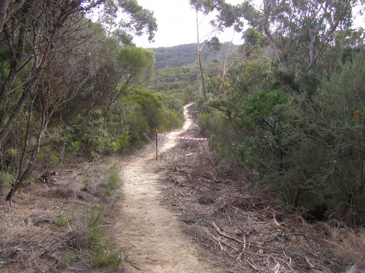
[Photo taken 20120915, published with permission]
.
In January 2005, the Blue Mountains Council set up a Blue Mountains East Timor Friendship Committee and a friendship relationship with Timor Leste (East Timor) to work with a community in Timor Leste.
The Blue Mountains Council has partnered with Hato Builico, one of the four Sub-Districts of Ainaro District, south west of the East Timorese capital Dili. The Council developed its ‘Hato Builico Strategic Plan 2008′ to improve the lives of this rural community through funding of a Community Centre Refurbishment, Sustainable Economic Development, Health and Well Being, Capacity Development, Education and Training, Capital Works Infrastructure; and Governance and Partnerships.’
[Source: Blue Mountains Council, ^http://www.bmcc.nsw.gov.au/yourcouncil/easttimorfriendship, accessed 20121027].
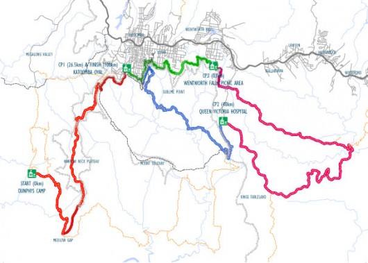
This committee has since decided to stage a fundraising event to raise money for East Timorese communities. The event is called ‘Trek for Timor‘, which seems now scheduled to be held every two years in September. The route traverses bushland between Wentworth Falls and Katoomba in the Blue Mountains, about 100km west of Sydney. It passes through the Jamison Valley Wilderness within the Blue Mountains World Heritage Area . There are four separate distances – 5km, 13km, 25km and 45km options to cater for varying levels of fitness of participants.
.
The Trek Route
.
Section 1 – Charles Darwin Walk through Valley of the Waters to Leura Cascades (13km trek 7am – 4pm)
Section 2 – Leura Cascades to Katoomba Park & Oval (25km trek 6am – 6pm)
Section 3 – Katoomba Oval alkong Narrowneck and through the Jamison Valley to Jamison Creek – “an unsupported checkpoint”
Section 4 – Jamison Creek via Kedumba Pass to Queen Victoria Hospital (45km Trek 6am – 1am)
.
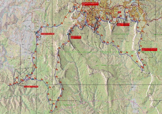
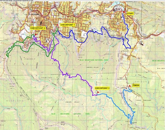 Trek For Timor – the 45km route map
Through the World Heritage listed Jamison Valley Wilderness (click image to enlarge)
[Source: Trek For Timor website, accessed 20121027, ^http://www.trekfortimorbm.org.au/wp-content/uploads/2012/05/2012-45km-route.pdf, >Read Map.pdf (2MB )]
.
The registration fee is $30 per person to cover costs and in addition each trekker (in teams of four to six) is asked to raise at least $150 in sponsorship for East Timor.
While a few tourist toilets are situated on parts of the course, participants may relieve themselves between checkpoints “make sure you move well off the track, and carry a trowel to dig a small hole to bury your waste.”
.
[Source: Trek For Timor, ^http://www.trekfortimorbm.org.au/].
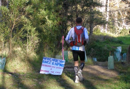
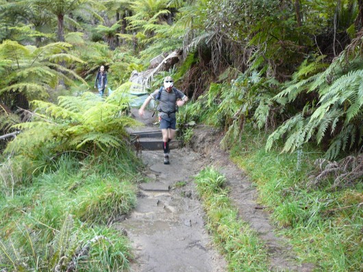
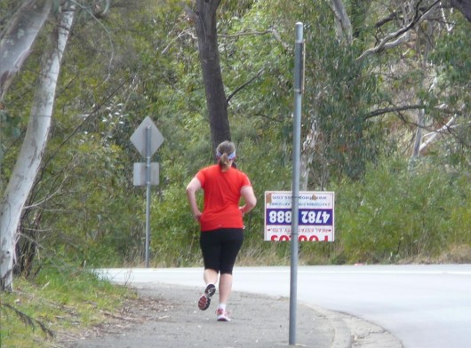 Trek for Timor particpant in September 2012
[Photo taken 20120915, published with permission]
.
While the cause seems noble, a key Blue Mountains problem of this event, like the many running that seemed to have cropped up in recent years, is that the Blue Mountains Council has routed the ‘Trek’ through Bushcare restoration sites and through creek beds, and there has been no environment impact assessment or community consultation in allowing for the event.
So while the cause may be noble, the means appears to be ignoble.
.
A Bushcare Volunteer’s Concerns about Environmental Damage
.
The following correspondence last month is between a concerned Blue Mountains Bushcare volunteer and Trek for Timor. Names have been omitted out of respect for privacy.
.
9th Sep (Bushcare Volunteer):
.
Dear Trek For Timor,
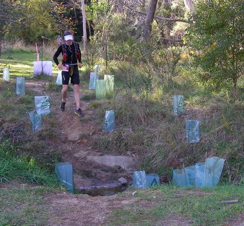
“As a local resident, environmentalist and Bushcare participant/bushland restorer, I am very concerned that the ‘Trek for Timor’ event will be passing through an environmentally sensitive area. Of great concern is the proposed creek crossing from Peckmans Road to the lower Katoomba Sports Oval. This area is (and has been for many years) a focus of environmental restoration.
I respectfully consider that three hundred and fifty ‘Trek for Timor’ participants crossing here would severely degrade the creek and its surrounds. Other crossings are also degrading the creek further downstream.
I consider the event can still take place but request that it by-pass the area of concern. I suggest it instead take a route that enters the adjacent top sports oval from Cliff Dr.
I look forward to your reply and understanding.”
Regards,
(Bushcare Volunteer)
.
9th Sep (Trek for Timor):
.
“Good Morning (Bushcare Volunteer),
I have been forwarded your email regarding your concerns raised about Trek for Timor route passing through the section near the lower Katoomba Falls Oval. I am the volunteer in charge of the route for this event and and thank you for letting us know your concerns.
You will of course be aware that any event held in the Blue Mountains area is subject to strict guidelines and requirements from Council.
Unfortunately the event is now only a few days away and it would be very difficult to change the route at such a late stage. There were also additional reasons due to traffic concerns and safety as to why the route was put around through the back of the reserve. Additionally, there are only 150 walkers who are registered to walk through this area, as the other walkers will be either stopping at the 5km or 13km checkpoints.
I would, however, be very interested to meet with you on site sometime this week to see if there is some signage we can use to draw the participants attention to care being taken in that area. Also, although we may be constrained in being able to change the route for this Saturday’s event, the event may be held again in 2014 and we would like to know your concerns so we can ensure that we avoid any environmentally sensitive areas, and have the time to plan any such re-route for that year.
Please let me know if we can meet at the reserve sometime this week (lunch times or prior to 9am would suit me best).
Thanks,
(Trek for Timor)”
.
10th Sep (Bushcare Volunteer):
.
Hello (Trek for Timor),
“Thanks for your reply of 10 Sept 2012 below to my email of 9 Sept 2012 further below.
I respond as follows:
1. Thank you for your offer but signage will not prevent degradation. I consider that 150 participants will degrade the sensitive creek where proposed to be crossed. The only way to prevent the degradation is to by-pass the area as suggested at point 3 below.
2. The Council has neither informed the local community nor environmental groups of the proposed event. Consequently, there has been no local input.
3. I consider the traffic and safety concerns can be readily addressed given the traffic and safety issues along Oak St should already exist. I note that instead of turning left into Peckmans Rd, the route could easily continue for approximately 200 metres along Oak St. without any further road crossings before entering the top sports oval. The participants could then walk around the perimeter of the top and lower sports ovals to maintain the required distances of the event.
4. Given the small variation, I believe the route can be changed within five days before the event commences this Saturday.
5. Respectfully, the event could be seen as environmentally unsustainable should it proceed as currently planned.
I look forward to your reply and trust the event will now be re-routed.”
Regards,
(Bushcare Volunteer)
.
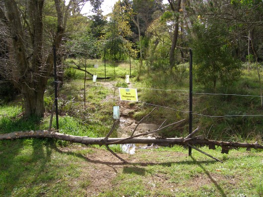
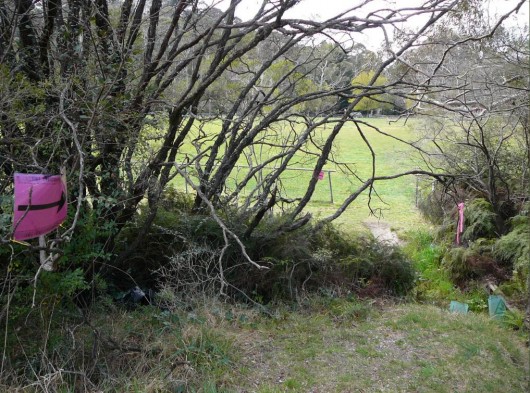 Trek For Timor route over creek restoration site, Katoomba
[Photo taken 20120915, published with permission]
.
11th Sep (Trek for Timor):
.
Dear (Bushcare Volunteer)
“Our committee has given full consideration to your suggestion and has sought Council’s advice on your request to reroute the trek. Both Council and the Trek for Timor organisers have safety concerns regarding your suggested alternative route, especially the very busy intersection of Kamilaroi Rd, Katoomba Falls Rd & Cliff Drive.
As we are sure you will agree, the safety of the trekkers is paramount.
The Environment Sustainability Officer of Council has also advised us that he considers the trek will have little or no impact on the crossing we will be using.
Having considered your request, taking advice from Council and following our committee discussions we have decided to continue with the course as planned. Our offer of signage advising the trekkers to take care when crossing the creek still stands.
Thank you for raising your concerns with us. Please direct all future correspondence to BMCC’s Environmental Sustainability Section.”
Regards,
T4TBM Organising Committee
(Trek for Timor)
.
14 Sep (Bushcare Volunteer):
.
Dear (Trek for Timor),
Thank you for your reply of 11 September 2012 below to my email of 10 September 2012 further below.
I respond as follows:
1. I think it is inappropriate for me to only direct my concerns to Blue Mountains City Council especially when the “Trek for Timor Blue Mountains Organising Committee” has organised the event. I also consider it necessary for me to respond to your replies of 10 and 11 September 2012 to dispel some misconceptions.
2. I wish to remind you that there has been no local input given Blue Mountains City Council has neither informed the local community nor environmental groups of the proposed event. Please provide me with the name of the Council’s “Environment Sustainability Officer” whom you contacted and their correct title, as I am only aware of the manager and administration and education officers carrying this title.
3. Once again, thank you for your offer but signage “advising the trekkers to take care when crossing the creek” will not prevent its degradation. The only way to prevent the degradation is to by-pass the area as suggested at point 6 below and point 3 in my email of 10 September 2012 further below.
4. I consider that environmental qualifications are not needed to understand that 150 “trekkers” crossing a muddy creek will damage it and the riparian vegetation. As such, I consider that any alternative unfounded view could be seen as deceptive and misleading.
5. You state that “Both Council and the Trek for Timor organisers have safety concerns regarding your suggested alternative route, especially the very busy intersection of Kamilaroi Rd, Katoomba Falls Rd & Cliff Drive.” Yet your replies of 10 and 11 September 2012 neither alerted me that the route would be crossing Katoomba Falls Rd during the very busy weekend traffic from the Katoomba Sports Oval towards the Katoomba Falls Kiosk for the 25 km and 45 km events, as is indicated on your web site. I also note that the detour I suggested on 10 September 2012 and at point 6 below passes through this location without any extra road crossings and so does not create any additional safety concerns and thus required additional resources that should already be addressed. Accordingly, I consider that it would be fair for me to say (and anyone reading this email) that all replies (and alleged replies) received by me from those involved in the “Trek for Timor” event to date are unfounded, perhaps misleading and deceptive.
6. I consider that there is ample time to change the route so that the participants can enter Katoomba Sports Oval off Cliff Drive. Traffic marshals and signs could be easily moved from Peckmans Rd to Kamillaroi Rd and Cliff Dr, as well as informing participants of the detour at the start of the event. Unlike the planned route, I note the detour does not require the participants to cross Katoomba Falls Rd.
7. Should the event continue to cross the creek adjacent to Peckmans Rd as planned and any other creeks in this area, it appears to me that the “Trek for Timor Blue Mountains Organising Committee” does not wish to acknowledge and address the concerns of local residents and environmentalists who have cared many years for this sensitive area.
I look forward to your reply and trust the ‘Trek for Timor Blue Mountains Organising Committee’ will reconsider re-routing the event.”
Regards,
(Bushcare Volunteer)
.
23 Sep (Bushcare Volunteer):
.
Dear ‘Trek for Timor Blue Mountains Organising Committee’,
Further to my email of 14 September 2012, I note the following:
1. The ‘Trek for Timor Blue Mountains Organising Committee’ did not reply to my email of 14 September 2012 below.
2. The ‘Trek for Timor’ event was not re-routed but instead went ahead on 15 September 2012 and crossed the creek adjacent to Peckmans Road despite ongoing prior concerns, requests, a suggested feasible alternative route and opportunities not to do so.
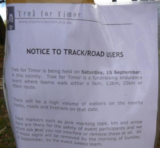
3. A ‘Trek for Timor’ notice erected next to the entrance of upper Katoomba Falls Sports Oval acknowledged that “there will be a high volume of walkers” participating in the “Trek for Timor” event.
4. Despite the ‘Trek for Timor’ event being advertised as a “walking” event, a number of participants were instead seen running the event, including at the creek crossing. These participants were also strongly encouraged to do so by ‘Trek for Timor’ marshals.
5. As indicated on the ‘Trek for Timor’ web site, the ‘Trek for Timor Blue Mountains Organising Committee’ (together with Blue Mountains City Council) was prepared to re-route participants up Cliff Drive and onto Birdwood Avenue in the event that Prince Henry Cliff Walk was closed during the event yet did not want to re-route the event along a safer stretch of road to prevent a creek crossing. I note locals consider Cliff Drive and Birdwood Avenue to be very dangerous roads for pedestrian use due to the number of sharp bends, the steep slope, the lack of safe pedestrian access and the speed and size of vehicles that utilise these roads.
Consequently, I consider the ‘Trek for Timor’ event has caused environmental damage to the creek adjacent to Peckmans Road and its riparian vegetation. In addition, I consider that the ‘Trek for Timor Blue Mountains Organising Committee’ disregards local community concerns including the community’s efforts in protecting and restoring environmentally sensitive areas for more than twenty years.
I trust future “Trek for Timor” events will no longer take place in Upper Kedumba River Valley.
Yours faithfully,
(Bushcare Volunteer)
.
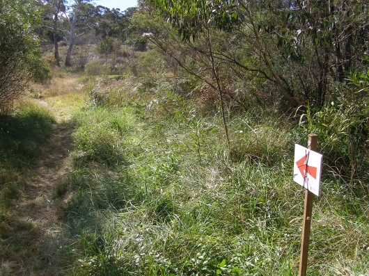
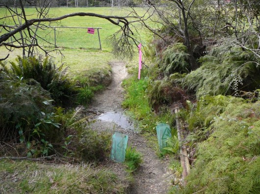 Eroded creek crossing along Trek For Timor route
[Photo taken 20120915, published with permission]
.
.
Editorial Comments:
.
[1] There appears to have been no community consultation process facilitated by either the Blue Mountains Council or Trek for Timor – genuine, fair, transparent or otherwise. Local interested stakeholders such as local Bushcare Groups appeared to have not been consulted in respect to the event itself and the route chosen. Bushcare Volunteer: “there has been no local input given Blue Mountains City Council has neither informed the local community nor environmental groups of the proposed event.“
.
[2] No environmental assessment appears to have been conducted by the Blue Mountain Council or by the local New South Wales National Parks and Wildlife Service. Trek For Timor’s claim of there being “strict guidelines and requirements from Council” are not publicly available. What are the “strict guidelines and requirements from Council”, if any?
.
[3] The decision by Blue Mountains Council to allow the course route to traverse a sensitive creek watercourse that is under remediation as a Bushcare site is contrary to the ecological restoration and native habitat conservation objectives of Bushcare. The creek site is within 200 metres upstream of Katoomba Falls and the Greater Blue Mountains World Heritage Area. There appear to be no control limits on the numbers of participants and their support crews.
[4] The cumulative impacts of tramping and soiling by the Trek for Timor and other similar running events upon the local natural environment appear to have not been environmentally assessed. Any such assessment outcomes by Council’s Environment Sustainability Officer is not readily available on either the Blue Mountains Council website or on the Trek for Timor website.
Similar running events through the natural bushland of the Blue Mountains that have been approved by Blue Mountains Council in recent years are:
.
- Trek For Timor ^http://www.trekfortimorbm.org.au/
- Wild Endurance marathon ^http://www.wildendurance.org.au/
- Northface 100 marathon ^http://www2.thenorthface.com.au/100/
- Coolrunning Australia ^http://www.coolrunning.com/
- Six Foot Track Marathon ^http://www.sixfoot.com/
- Running Wild NSW ^http://www.runningwildnsw.com/
‘Running Wild is keen to provide NSW runners with opportunities to regularly run on trails and where better than in the Blue Mountains National Park. The park covers a huge area and is already known for great races such as the Woodford to Glenbrook, the Six Foot Track and The North Face 100, but there are many other excellent trails out there, just waiting to be run. Our vision is to bring new and exciting trail races to all runners, which is also good for us, as it gives the committee a really good excuse to get out on the trails and run more, to find even better trails to share.”
[Source: Running Wild NSW ^http://www.runningwildnsw.com/about/
.
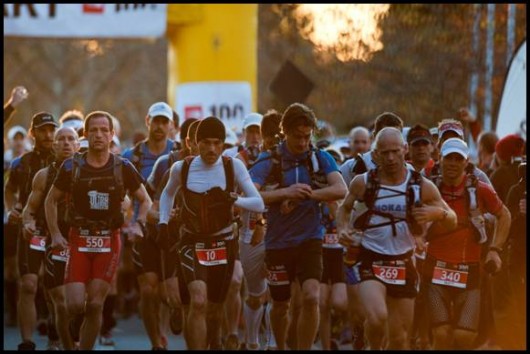
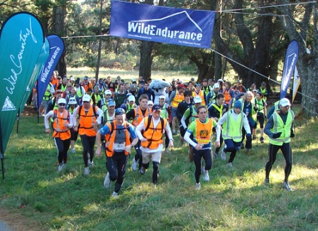
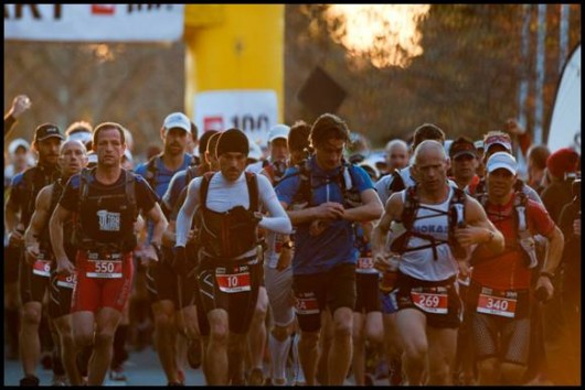 Northface 100 competitors head off on a similar route through the Blue Mountains World Heritage Area
.
[5] The current trend of adventure recreation and adventure tourism have not been adequately assessed by the government custodians of the environmentally sensitive and ecologically important vegetation communities in which these activities have been allowed. Adventure Tourism is an ongoing threat to the integrity and health of native habitat.
.
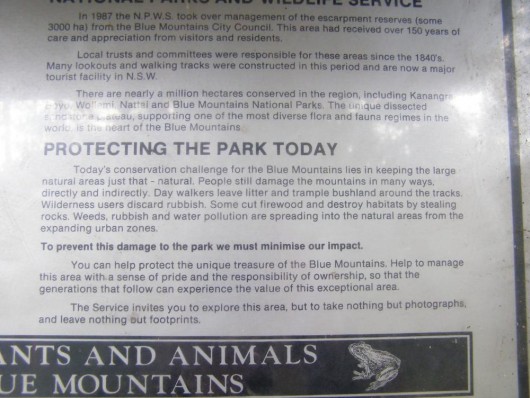 Blue Mountains National Park sign at Katoomba along the route
The custodians of the National Park have abandoned their core conservation values for tourism
[Photo by Editor 20120706, licenced under ^Creative Commons]
.
Read more on this website about:
