Tasmania’s Forcett Fire 2013 – 16 questions
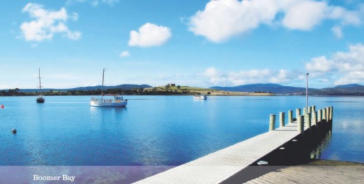
Sunday, February 3rd, 2013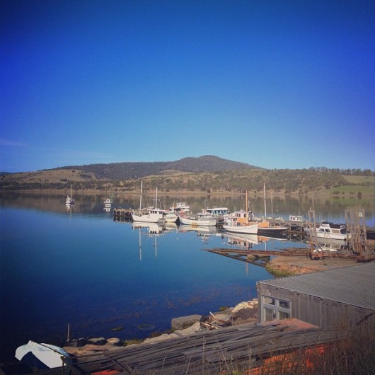 Dunalley Wharf, Tasmania ~ idyllic serenity
Now with far greater meaning
.
On that blistering hot Friday 4th January 2013…this same wharf became a life saving critical refuge. Desperately trapped residents fled their homes from a raging inferno bearing down upon them and clung below the wharf for dear life, immersed in the cool salt water.
Dunalley’s Wharf became a final refuge for people of Dunalley to survive what would otherwise have been certain death by bushfire. It’s unassuming but vital human value is now etched in local memory, which must now already be legend.
Such horrific memories are destined to endure local lifetimes.
What let the firestorm descend upon Dunalley was negligently and morally wrong. It was stoppable on the 3rd and the escalated firestorm should never have come to this.
No-one deserves this, ever!
.
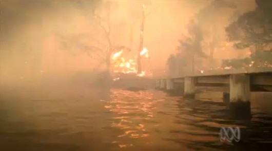 Dunalley Wharf, a special place.
.
Dunalley: a bushfire-vulnerable community
.
The small rural fishing village of Dunalley is situated along on a sheltered coastline in south eastern Tasmania adjacent to established grazing country and immediately surrounded by hilly bushland.
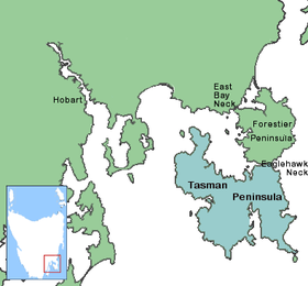
Tourists drive through Dunalley from Hobart enroute down to the popular Tasman Peninsula where historic Port Arthur is situated. A smaller coastal village of Boomer Bay lies 1km to the north of Dunalley.
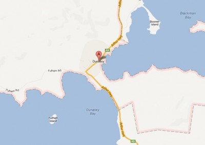
Zooming in, Dunalley is positioned on a narrow 700 metre wide isthmus of land between Dunalley Bay and Blackman Bay that connects the main island of Tasmania to the Tasman Peninsula – ‘East Bay Neck‘.
The Denison Canal cuts this isthmus and the town in two providing a boating shortcut transit between the two bays (like a micro version of the Panama Canal) . The Arthur Highway crosses over the canal at the Denison Canal Bridge.
 “..Water, water everywhere, nor any drop to drink.”
~ The Rime of the Ancient Mariner by Samuel Taylor Coleridge.
Dunalley is surrounded by water on both sides
(Denison Canal not shown)
.
Dunalley has for over a century been a sawmilling and fishing town, but over recent decades has seen growth as retirees and holiday makers buy up and extend the population to just under 400 with new housing development communities like adjacent Primrose Sands sprouting up.
.
QUESTION 1:
.
What contribution and culpability have (1) housing planning approvals by local Sorell Council and (2) Sorell Council enforcement and compliance monitoring of Australian building standards in bushfire prone areas, played in susceptibilty of properties in Dunalley and Boomer Bay to bushfire damage? What role and approval if any has the Tasmanian Fire Service had in these housing planning approvals?
.
Like so many rural communities across Tasmania and indeed south eastern Australia, the rural lifestyle appeal of coastal villages like Dunalley is the traditional timbered cottage amenity and the rustic bushland setting. Dunally also has the sheltered bays to complement its appeal.
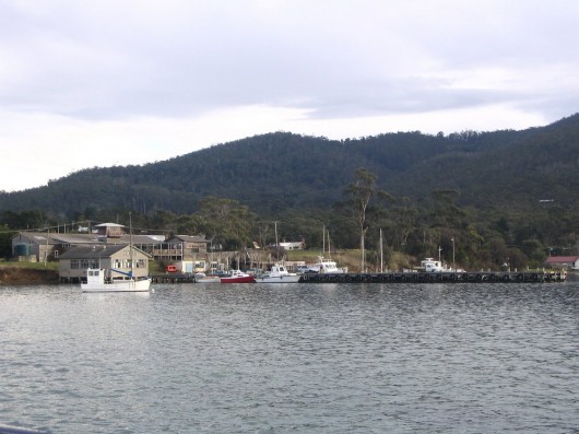 Dunalley Wharf and Fish Market looking north from Dunalley Bay,
with steep Township Hill in the background (long before the 2013 bushfire).
.
However, the geographic restrictions of Dunalley being:
- Surrounded by coastal waterways
- Close proximity to bushland (a substantial ‘urban bushland interface‘)
- Dunalley’s juxtaposition downwind of the prevailing north-west wind from extensive bushland vegetation
..all combined make Dunalley an inherently bushfire vulnerable community. In the event of a bushfire, normal expected evacuation by road would be restricted.
Indeed, evacuation from the dependengt Forestier Peninsula and sub-dependent Tasman Peninsula had to be both effected by sea, since the logistically vital Denison Canal bridge became impassable due to the bushfire emergency.
.
QUESTION 2:
.
What bushfire risk assessment, community education, community bushfire preparation and bushfire evacuation procedures had the Tasmanian Fire Service provided to the communities of Dunalley and Boomer Bay in the years, months, days ahead of the January 2013 bushfire?
.
QUESTION 3:
.
Did most residents of Dunalley and Boomer Bay consider their individual properties and their communities in general particularly vulnerable to bushfire? If so, what bushfire mitigation measures had been previously discussed and actually implemented. If not, why not?
.
Following Victoria’s tragic Black Saturday bushfires of 7th February 2009, in addition to the subsequent Royal Commission, a study by a team of scientists from Australia and America examined 500 of the homes that were affected by the bushfires.
The study sought to learn from effects of land management on house loss to identify how houses could be better protected in future bushfires. The study compared the impacts of bushfire preparation measures like prescribed burning, grazing, logging of native forests, and the clearing if immediate bush on the survivability of houses in a bushfire.
The key result was that getting rid of vegetation ( trees and shrubs) within 40m of a house was by the most effective property preparation measure. Whereas measures such as logging native forests and prescribed burning had minimal impact on reducing house loss. The results of the study were published a year ago on 19th January 2012 in the online scientific journal ‘PLoS ONE‘.
Professor David Bowman, an expert in forest ecology and bushfire management at the University of Tasmania in Hobart, says this research is useful because it confirms scientifically what we already know.
“It’s really important that we get more effective at mitigating the effects of bushfires,” says Philip. “It does open up some pretty intense political issues,” he says. “You’ve got to ask the question: why are people living in these areas if these disasters are only going to keep happening? Why do peri-urban communities exist?”
Population growth in bushland areas and more frequent bushfire weather predicted with climate change are expected to create major challenges for protecting homes in the future.
.
[Source: ‘Black Saturday study looks at bushfire risk’, by Natalie Muller, January-19-2012, ^http://www.australiangeographic.com.au/journal/black-saturday-bushfire-study-reveals-how-stay-safe-victoria-kinglake.htm].
QUESTION 4:
.
What if any vegetation clearing buffer was conducted by the TFS immediately between Dunalley and the bushland recently and when was this done?
.
QUESTION 5:
.
What if any vegetation clearing buffer was conducted by property occupiers of Dunalley immediately around their properties recently and when was this done?
.
QUESTION 6 :
.
What if any bushfire preparation was conducted by property occupiers of Dunalley immediately around their properties recently and when was this done?
.
Another Odd Hot Summer
.
Historically, Tasmania’s southern latitude, and the fact that it is surrounded by sea, has generally meant that summer temperatures across Tasmania have been fairly mild in comparision to the increasingly scorching heatwaves that have beset mainland states over recent decades.
But Tasmania, on occasions does get summer heatwaves into the high 30s Celsius and hotter, notably on record during the summers of:
- 1895-96
- 1907-08
- 1939-40
- 1945-46
- 1967-77
- 1976-77
- 2008-09
- 2012-13 (just gone)
And so it was that at the start of summer on November 30, 2012, the Australian Government’s Bureau of Meterology forecast another unseasonally very hot summer for Tasmania and a media report ran thus:
.
<<Today marks the beginning of the bushfire danger season in Tasmania — with temperatures forecast to soar. The mercury is tipped to go over 30C in the South today, prompting the Tasmania Fire Service to declare the season’s first total fire ban.
Hobart is forecast to reach 32C, while Campania and Richmond can expect 33C. Yesterday was also a hot one, with Hobart recording a maximum of 30C – 11 degrees above the November average.
The state’s top temperatures yesterday were recorded in Ouse, 32.6C, and Strahan, 32.5C.
TFS chief officer Mike Brown urged everyone living in and around bushland to review their bushfire plans. He said today’s fire ban was in response to the high temperatures and dry conditions.
“The vegetation across the state has dried out measurably despite recent scattered light rain.. today’s high temperatures meant fires could “develop in size very quickly and be difficult to control”. “There are a number of fires across the state that have been difficult to control and extinguish,” Mr Brown said.
Last night fire crews were at six vegetation fires across the state, the largest burning out of control around Poatina Rd, Central Plateau.
Southern Water has also introduced water restrictions today in response to the dangerous conditions. People should avoid all non-essential water use to leave enough for fire fighting.
Weather bureau senior forecaster Malcolm Downing said it was the first “very high danger” rating for the fire season. Mr Downing said there had been little rain over the past two weeks, which had significantly dried out vegetation. He said tomorrow should be cooler, with temperatures forecast to be in the low 20s.
Today’s total fire ban means that no fires can be started out of doors in the southern region, which includes the municipalities of Brighton, Central Highlands, Clarence, Derwent Valley, Glamorgan/Spring Bay, Glenorchy, Hobart, Huon Valley, Kingborough, Sorell, Southern Midlands and Tasman.
The ban started at midnight last night and remains in place until midnight tonight. Mr Brown said today’s fire ban also meant people could not use cutting, welding or other similar equipment in the open.
“Although the use of agricultural machinery, for the purpose of harvesting crops or slashing grass, is not included in this ban operators are requested to take particular care when using this type of machinery,” he said. Fires should be reported by dialling 000.
.
Total Fire Ban Rules
.
- No fires may be lit or be allowed to remain alight in the open air until midnight tonight.
- Tools and equipment that use a naked flame or generate sparks must not be used in the open air.
- Barbecues that use wood, charcoal or solid fuel banned.
- Gas and electric barbecues are permitted if the barbecue is a fixed permanent structure.>>
.
[Source: ‘Gearing up for a sizzler’, 20121130, by Anne Mather, The Mercury (Hobart newspaper), ^http://www.themercury.com.au/article/2012/11/30/367334_tasmania-news.html].
The following day, December 1, media reports alerted Tasmanians to several active bushfires across the state, and significantly one in Forcett.
.
<<The Tasmanian Fire Service says the threat from fires across the state has reduced, but has urged residents to continue monitoring conditions.
Containment lines have been set around the fires at Glen Huon, Bruny Island, Forcett and Geeveston. The largest blaze was located at Poatina on the Central Plateau.
The 6,000 hectare Poatina Fire is burning in bushland located near high transmission powerlines, that connect the state’s north and south.
Tasmania Fire Service spokesman Andrew McGuiness told ABC News the fire will probably destroy caravans at Jonah Bay tonight, saying “it’s a big fire and it’s likely to get significantly bigger before they can put containment lines into control it.”
Another fire at Glenlusk, north of Hobart, also continues to challenge firefighters as they try to bring it under control.
Milder temperatures have helped firefighters gain the upper hand today, however windy conditions prevailed. People who aren’t residents are urged to stay away from the fire zones, while communities near the fires are urged to be alert for any changes in the fire conditions. They should also continue looking at the Tasmanian Fire Service website for the latest updates.>>
.
[Source: ‘Wind and heat hampers bushfire fight’, 20121201, by Tim Gerritsen, ABC News, ^http://www.abc.net.au/local/stories/2012/11/30/3644822.htm].
The ‘Precedent Excuse‘ that this latest bushfire could be ‘the worst ever‘, or ‘the worst in 100 years‘, or in 200 years – simply doesn’t wash.
It’s like telling the low lying folk of Queensland’s Lockyer Valley in 2011 that they had experienced the worst in a hundred year flood event; only two years later in January 2013 to experience the worst in a hundred year flood, again.
The risk of ‘Force Majeur‘ is not a factor of time, but of fickle Nature – basically a factor of luck.
Such is a convenient myth perpetuated by the accountable Tasmanian Government to try to shun its planning responsibility that Dunalley’s bushfire disaster was somehow unforseeable, and to try to excuse its emergency response failure that the disaster and its impact were somehow unavoidable.
Pull the other one, its got bells on it. These days, both floods and bushfires in Australia are a consequence of both Nature, and the actions and inactions of Man.
Government bureaucrats and politicians may think the people are silly, like believing the old saying that ‘lightning never strikes the same place twice‘. The factors that cause lightning to strike once don’t disappear between storms or even within the same storm.
.
.
QUESTION 7:
.
Since Tasmania’s infamous 1967 fires when the Tasmanian Government forewent any plausible excuse it may have had of ‘bushfire innocence’, what subsequent measures and investment have been taken by the Tasmanian Govermment in (1) bushfire emergency planning and (2) bushfire emergency response – to mitigate the spread and impact of wildfire? Given that the Dunalley Bushfire Disaster occurred have these measure and investment been adequate in meeting community expectations of government responsibility in 2013?
.
.
QUESTION 8:
.
What specific extra-ordinary bushfire fighting resourcing and strategies did the Tasmanian Fire Service seek and have implemented once it became aware of the forecast extreme bushfire weather conditions, and given that multiple uncontrolled bushfires, including the 6,000ha Poatina Fire, were demonstrating the extreme nature of the fire behaviour and already commanding TFS fire-fighting resources?
.
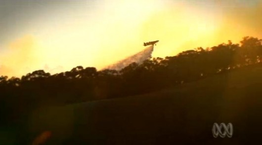
Dec 2012 Two Air Tractor 802 Fire Bombers secured
.
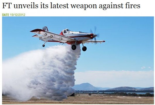 Air Tractor 802 fixed wing dedicated water bomber
.
Just two weeks ahead of the Forcett Fire, the Tasmanian Government’s corporatised forestry department, Forestry Tasmania, announced that it has secured two dedicated waterbombing aircraft from Victoria to be based at Hobart Airport (Cambridge).
Significantly, Forestry Tasmania holds the State’s monopoly delegated management responsibility for Tasmania’s native forest reserves, in which it exploits for commercial timber logging.
Two large native forest reserves were ultimately impacted by the Forcett Fire – one south of the Arthur Highway in the Sorell local government area that includes ‘Big Blue Hill‘ which appears to have no identifiable name, and the other on the Forestier Peninsula – ‘Yellow Bluff Creek Forest Reserve‘.
.
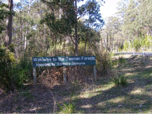 What does ‘managed’ mean?
[Photo by Editor, 20110926, free in public domain]
.
<<Forestry Tasmania unveiled its latest weapon in the fight against forest fires at Cambridge Airport earlier this month. The two Air Tractor 802 fixed wing fire bombers were brought to Hobart from Ballarat (regional Victoria) for a week and were immediately put into action, fighting a bushfire at Musselroe Bay in the far North-East (Tasmania).
A private airstrip nearby enabled them to fill up with a mixture of water and foam from temporary inflatable tanks and be over the fire in minutes.
With a capacity of more than 3000 litres and taking just four minutes to fill up, the two Air Tractors, valued at $1.5 million each, dumped 40,000 litres in an hour and more than 150,000 litres on the Musselroe Bay bushfire.
Forestry Tasmania hired the planes and pilots from Field Air with the help of the National Aerial Firefighting Centre. Forestry Tasmania fire management head Tony Blanks said it was the first time the Fire Tractors had operated “in earnest” in Tasmania, where helicopters were more commonly used.”
.
[Source: ft-unveils-its-latest-weapon-against-fires’, 20121219, Forestry Tasmania website, ^http://www.forestrytas.com.au/news/2012/12/ft-unveils-its-latest-weapon-against-fires].
Problem was that although one Air Tractor was vitally needed to fight the Forcett Fire, the second aircraft was previously returned back to Victoria at a time when dozens of fires were burning across Tasmania and with forecast extreme bushfire weather.
Madness. Why?
.
QUESTION 9:
.
In the wake of the Dunalley Bushfire Disaster what subsequent measures and investment is the Tasmanian Govermment to implement in (1) bushfire emergency planning and (2) bushfire emergency response to mitigate the spread and impact of future wildfire across the State?
.
Preparation for an Extreme Forest Fire Danger Index?
.
So by early December 2012 unusually extreme bushfire weather conditions were forecast for Tasmania. But this was what Tasmania had experienced previously, albeit occassionally, but not as unique as some sensationalists in the media would have us believe.
Significantly, from a bushfire management operational perspective, numerous bushfires were already active and occupying the Tasmanian Fire Service and its related agencies, the Parks and Wildlife Service and Forestry Tasmania, reducing resource capacity to respond to new and escalating bushfire emergencies.
Was the Tasmanian Fire Service by 3rd January already overwhelmed?
.
QUESTION 10:
.
Why did the Tasmanian Fire Service, well aware of the looming extreme forecast bushfire weather, not request special additional resources, such as from Victoria, including prudent preparatory delivery of the dedicated and proven effective waterbombing heli-tanker, then parked and idle in a hangar at Essendon Airport Melbourne?
.
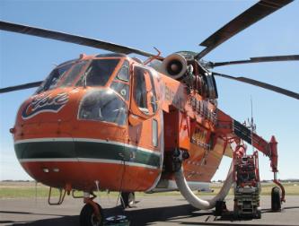
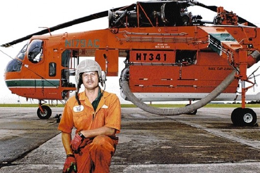 ‘Elvis’, the celebrated Erickson Heli-tanker, with specialist bushfire-fighting pilot
A converted Sikorsky S-64E Skycrane, with a special “sea snorkel” and water tank It is manufactured in Oregon, USA, dedicated to waterbombing bushfires and based at Essendon Airport Melbourne since December 2001. Australia’s mainland states now have invested in at least four of them for standby bushfire application. ^http://www.ericksonaircrane.com/full_story/fullstory_firefighting.html
.
.
Yet Tasmanian fire authorities defended their choice of aircraft to fight the state’s catastrophic south-east bushfire, while a much bigger helicopter stood idle on the mainland.
As the fires still burnt through the Tasman Peninsula on Sunday night, authorities warned that they held fears for a handful of people unaccounted for after the main fire passed.
The Tasmanian Fire Service’s chief officer, Mike Brown, said it had been an option to use the heavy-lift Erickson Air-crane against the blaze that devastated Dunalley and nearby coastal hamlets on Friday.
Under national aerial fire-fighting arrangements, five of the Air-cranes are positioned on the mainland, each of them able to suck up nine tonnes of water in 40 seconds, and fly at 200 km/h.
The aircraft, such as Victoria’s ”Elvis” and ”Gypsy”, have become part of bushfire folklore.
The Victorian CFA confirmed that in Melbourne on Friday, a day when the south-east fires were already burning in Tasmania in what were officially described as catastrophic conditions, one Air-crane went unused in its Essendon hangar.
Mr Brown said the Air-Cranes, which were heavily funded by the Commonwealth, still required a contribution from Tasmania.
”So we’ve got to have here what’s available in terms of being able to support as well,” he said.
”The support we can provide to the medium helicopters gives us, we think, the best outcome.”
A spokeswoman for the federal Attorney-General’s Department said moving the Air-crane also depended on moving refuelling capability.
Due to the nature of the aircraft, this was slower than moving smaller helicopters such as the Bell 212, she said.
More than 100 structures, many of them homes, have been lost in small communities, mainly around the Tasman Peninsula, but also near Bicheno on the east coast.
Acting Police Commissioner Scott Tilyard said searchers had scoured the burnt-out homes in the worst-hit towns of Dunalley, Boomer Bay and Bream Creek without finding any bodies, but the community still needed to brace for possible deaths.>>
.
[Source: ‘Elvis is left idle despite raging inferno’, 20130107, by Andrew Darby, Hobart correspondent for Fairfax Media, ^http://www.smh.com.au/environment/weather/elvis-is-left-idle-despite-raging-inferno-20130106-2cb6c.html].
Post-Dunalley – TFS Requests interstate assistance
.
Sunday, 6th January:
<<As a result of the ongoing fire situation across the state, Tasmania Fire Service has welcomed and accepted offers of firefighting assistance from interstate authorities.
This will be in the form of personnel and will give some Firefighters and Incident Management Teams (IMT) the chance to have a break, as well as boosting firefighting numbers where needed.
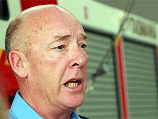 TFS Chief Officer, Mike Brown
.
TFS Chief Officer Mike Brown said:
“Tasmanian Firefighters have had a long record of providing assistance interstate and internationally over the years and our peoples skills and capabilities are highly regarded. I have been contacted by many of my counterparts from Western Australia through to New Zealand and many jurisdictions in between with messages of encouragement and offers for assistance.
Yesterday I spoke with the NSW Rural Fire Service Commissioner and the Victorian Fire Commissioner and arranged for Firefighters and Fire Specialists to provide some much needed relief for our people. I’m very grateful that they have been able to respond so quickly”.
.
The following are confirmed interstate deployment numbers coming to Tasmania:
- 7 x Rapid impact assessment officers from NSW Rural Fire Service (6 arrived yesterday, 1 today)
- 4 x liaison officers arrive today
- 17 x IMT personnel from Country Fire Authority Victoria, Department of Sustainability and Environment Victoria, & MFB arrive Sunday for Hobart
- 4 xIMT personnel arrive Sunday for Launceston
- 7 x Air operations arrive Sunday for Hobart
- 33 x Strike team firefighters arrive Sunday for Hobart (using TFS vehicles)
All personnel are due to return home on Friday.
“The potential for further requests for assistance will be considered later this week” TFS Chief Officer Mike Brown added.
.
[Source: Tasmanian Fire Service, Sunday 20130106, ^http://www.fire.tas.gov.au/Show?pageId=colMediaReleases].
[Ed: Better late than never, but tell that to the folk of Dunalley, Boomer Bay, Connelly’s Marsh and Copping!]
.
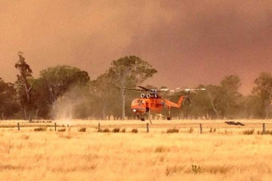 Erikson Aircrane deployed to the Forcett Fire on 3rd January? If only!
Sorry, this machine was deployed in Dawson in Gippsand, Victoria this month.
Same landscape, different State.
.
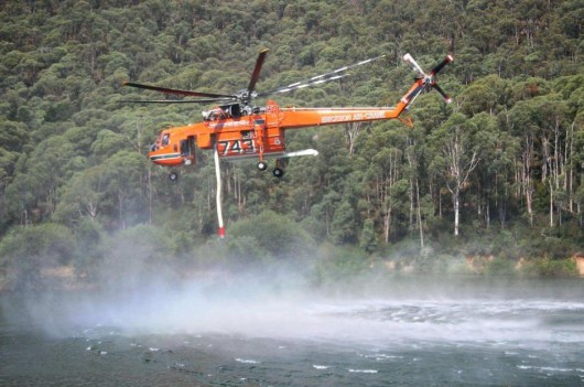 Erikson Aircrane deployed to the Forcett Fire on 3rd January? If only!
Sorry, this machine was deployed in Alpine Fire near Harrietville in Victoria this month.
..
When bushfire weather conditions become extreme – tinder dry bush and long grass, low humidity, temperature in the high 30 degree Celsius or hotter and strong winds – then the bushfire risk is exponentially heightened.
Bushfire risk is measured by the McArthur Forest Fire Danger Index (FFDI), which was developed in the 1960s by CSIRO scientist A.G. McArthur to measure the degree of danger of fire in Australian forests.
This Forest Fire Danger Index combines a record of:
- Vegetation Dryness (based upon rainfall and evaporation)
- Windspeed
- Temperature
- Humidity
.
A fire danger rating of between 12 and 25 on the index is considered a “high” degree of danger, while a day having a danger rating of over 50 is considered an “Severe” fire danger rating. Above this level in 2010 a distinction was made between Forest and Grassland fuels.
For Forest fuels, an FDI over 75 is categorised as “Extreme” and over 100 as “Catastrophic”. In Victoria, the alternate rating name adopted for Catastrophic is “Code Red”.
For Grassland fuels the threshold FDI values for the Extreme and Catastrophic Ratings was increased to 100 and 150 respectively. However,in Western Australia, which currently only uses the Grassland FDI, the values of 75 and 100 were being used as thresholds during 2012.
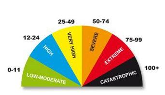 Fire Danger Ratings (from 0 to 100+)
‘Catastropic’ is a new category introduced across Australia since the Victorian ‘Black Saturday’ tragedy of February 2009
.
McArthur used the conditions of the Black Friday fires of 1939 as his example of a 100 rating. The FFDI on Black Saturday, 7 February 2009, reached more than 200.
However, grassfires present a higher risk than forests under the same bushfire weather conditions, simply because grass is more flammable than timber.
.
National Framework for (bushfire) Scaled Advice and Warnings
.
In Victoria, in the months following the devastating Black Saturday bushfire disaster of February 2009, in which 173 people perished under catastrophic bushfire conditions ( a FFDI of over 200), new fire danger ratings were formulated based upon this fire danger index.
The ‘Low’ rating was merged with ‘Moderate’ and a new ‘Catastrophic’ rating was introdiuced over and above what had long been the top rating of ‘Extreme’.
The new Catastrophic (Code Red) rating involves a fire danger index above 100. Under these types of weather conditions fires will be unpredictable, uncontrollable and fast moving. The fires in Victoria on 7th February 2009 provide an example of the types of fires that may be experienced under a ‘Catastrophic’ rating.
Standard advice to communities under these conditions will be that leaving is the safest option for survival.
.
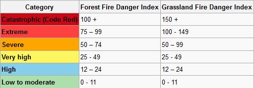 Australia’s National Fire Danger Ratings
since Sep 2009
.
Australia’s new ‘National Framework for Scaled Advice and Warnings‘ were agreed and adopted by all Australian States and Territories at the Australian Emergency Management Committee meeting on 3rd and 4th September 2009. One would presume that this included Tasmania.
.
The national framework includes:
- The new Fire Danger Ratings (see above coloured table)
- The vague bushfire management slogan ‘Stay or Go’ replaced by similarly vague slogan: ‘Prepare, Act, Survive‘. *
- An agreed format for scaled warnings.
.
Other agreed bushfire management emergency protocols also include:
- Forecast fire danger advice will be issued throughout the media and will be aligned to the new fire danger ratings (which is based on the fire danger index)
- Key messages have been designed to clearly communicate what is likely to occur if and when a fire starts for each of the fire danger ratings. Messages will include specific actions for the community to take during this outlook period.
- The CFA Chief Officer will have responsibility for issuing warnings to the community during fires; delegated to local Incident Controllers with a backup in the State Duty Officer in the iECC.
- Information units will have operational guidelines and the technological capability in place to enable them to quickly issue accurate warnings. Approval will occur at local incident level by the IC or deputy IC.
- Where an ICC has not yet been established, warnings can be issued on behalf of the IC by information units in the RECC or iECC.
- Warnings will be disseminated throughout a variety of media, for example websites, local radio and VBIL simultaneously via a single entry tool known as One Source One Message (OSOM). This will ensure that warnings are provided to all sources at the same time, will appear in the same format and contain the same language.
- The iECC (or SECC) Information Unit will play a monitoring and auditing role in relation to community warnings, as well as a pro-active role when a warning hasn’t been issued or released.
- All areas will have access to OSOM* (warning system). It can be issued at a very local level (for example at a regional office before an ICC has been set up) or in the iECC which will be manned throughout high fire danger rating or fire danger indicator days
- In accordance with Royal Commission recommendations, there will be two warning categories, and three levels of information:
.
-
- ‘ADVICE‘: This will advise you that a fire has started but there is no immediate danger, and includes general information to keep you up to date with developments.
- ‘WATCH AND ACT‘: This is a heightened level of threat. Conditions are changing and you need to start taking action now to protect you and your family.
- ‘EMERGENCY‘: This will indicate that people in specific locations are in danger and need to take action immediately to protect life, as they will be impacted by fire.
.
* NB. The One Source One Message (OSOM) tool is a system with a single, multi-agency web-based portal to publish real time messages using standard incident management templates.
.
[Source: ‘New warning system explained’, by Bushfire Preparedness Program 2009/10, Victorian Country Fire Authority, 20090910, ^http://www.cfaconnect.net.au/index.php?option=com_k2&view=item&id=873].
Ed:
A clearer, unambiguous bushfire response slogan to replace ‘Prepare, Act, Survive‘ could be:
.
‘No Bushfire Defence Certificate?
Self-evacuate now to your nearest registered Emergency Evacation Centre!‘
.
It is high time that under bushfire rated conditions that are ‘Severe’ or ‘Extreme’ and when a wildfire is within a given risk range, that governments legally compel all residents situated in high bushfire-prone areas to compulsorily self-evacuate to a registered Evacation Centre unless they hold a current Bushfire Defence Certificate.
Such a certificate would at a minimum require:
.
(1) Meeting minimum standards of building construction in compliance with the Australian Standard for construction of buildings in bushfire prone areas (AS 3959-2009)
(2) Preparation of property bushfire defence inspected and certificied by a bushfire delegated authority for the current season
.
Under bushfire rated conditions that are ‘Catastrophic’ and when a wildfire is within a larger given range, ALL bushfire-prone residents, ought to be legally compelled to compulsorily self-evacuate to a registered Evacation Centre, irrespective of whether they hold a current Bushfire Defence Certificate or not.
.
.
No Fire Danger Index used by TFS in the Forcett Fire
.
Although, this bushfire danger rating system was officially in place across Tasmania since late 2009, the Tasmanian Fire Service chose not to include fire danger indices on its website or via the Tasmanian media. Why not?
The following remains the format of the TFS public notice of active bushfires; in this case the ‘Forcett Fire’:
FORCETT FIRE:
.
<<Alert Level: [Going] Advice
Type: VEGETATION FIRE
Last Updated: 13-Jan-2013 8:18 AM
First Reported: 03-Jan-2013 2:13 PM
Location: Inala Road, FORCETT
Status: Going
Agency: Tasmania Fire Service
Incident Number: 201651
Size: 24,040 Ha
Details: Bushfire Advice Message FORCETT FIRE 201651 Current from:13/01/2013 08:12 AM until: 13/01/2013 11:00 AM or further notice There is a large bushfire at between Forcett and the Tasman Peninsula . The fire danger rating in this area is forecast to be high for today. Fire under these conditions can be difficult to control . There is no immediate threat to communities. This bus …
More Info | Current Incident List>>
.
[Source: TFS website, 20130113, ^http://www.fire.tas.gov.au/].
QUESTION 11:
.
How effectively then, does the above bushfire information by the TFS assist potentially impacted people to be appropriately informed about the fire risk category of danger, the spatial fire threat (where it currenty is, which direction the fire front(s) is/are currenty headed, how fast it is moving, forecast changes), the timing of the threat to various ‘at-risk’ people? How effectively does the above bushfire information assist these people to appropriately prepare to either defend their properties or else to self-evacuate? Where are the registered evacuation centres for people?
.
QUESTION 12:
.
In Tasmania, does the Tasmanian Fire Service measure, use and publish a specific forecast and actual Fire Danger Index based upon weather information received from the Bureau of Meteorology? Does the TFS use the Forest and/or Grassland index? Why were such indicators not provided on the TFS website or via the Tasmanian media in relation to the current 2012-13 summer season ahead of and during the recent bushfire emergencies across the State? Is the publicised TFS bushfire emergency information adequate?
.
3 Jan 2013: Forcett Fire Reported
.
It is not officially publicly reported how the Forcett Fire was first detected by the responsible bushfire fighting authority, the Tasmanian Fire Service on the 3rd January 2013, except that the Tasmanian Fire Service website states consistently in successive daily updates that the “First Reported time was “03-Jan-2013 2:13 PM” at Location “Inala Road, FORCETT“.
After the disaster impacting Dunalley, Boomer Bay, Copping and other communities, on Tuesday 8th January, as the result of detailed investigations jointly conducted between Tasmania Police and the Tasmania Fire Service, the cause of the fire commonly referred to as the Forcett Fire had been officially determined.
<<The cause has been determined as of an accidental nature with the fire emanating from an old fire in a burnt out tree stump at Forcett. This fire has smouldered through the root system and ignited in the weather conditions of Thursday 3 January.
Detectives and Fire Scene Examiners from the Tasmania Fire Service have interviewed all available witnesses and people with information thereby assisting in their determination on the fire.>>
[Source: ‘Forcett fire – cause determined’, 20130108 2:34pm, Tasmanian Police, ^http://www.police.tas.gov.au/news/posts/view/3789/forcett-fire-cause-determined/].
But this ‘determined cause’ was the consequence of a prior fire that has not been publicly reported. The reason for the relatively prompt cause being determined and officially declared by the Tasmanian Police was to legally trigger insurance claim processing to the insured victims, which is understandable.
However, the original cause of the “old fire in a burnt out tree stump at Forcett” remains publicly undetermined.
The Tasmanian Fire Service website states that the fire ignited near Inala Road, Forcett on 3rd January 2013. Inala Road is situated about 2km east of the rural village of Forcett along the Arthur Highway. It is a one kilometre long gravel No Through Road that connects half a dozen farm properties to the Arthur Highway. See map below.
.
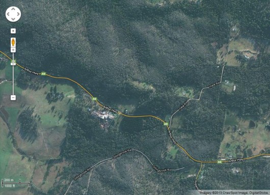 Inala Road Forcett Satellite Map, 2011
Click image to enlarge (Inala Road is top right)
[Source: Google Maps]
.
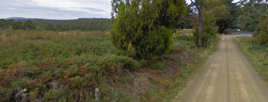 Inala Road near the intersection of the Arthur Highway in 2010
Photo looks south, with the hills toward Dunalley on the left.
Inala Road is characterised by farmland interspersed with partially deforested native bushland, and patchy regrowth.
Click image to enlarge.
[Source: Google Maps, March 2010]
.
Inala Road is easily accessible by fire trucks, so with a small fire and with low wind conditions, the prospect of suppressing the fire early on the afternoon of Thursday 3rd January would have been greater than at any subsequent time before it impacted Dunalley 24 hours later.
The exact location of the ignition along Inala Road has not been reported by the Tasmanian Fire Service on its website. Like most fore agencies, the Tasmanian Fire Service chooses to delete (censor) operational fire records after a few days.
However, a Forcett Fire Map provided on the ABC News website dated 4th January 2013 was obviously obtained by the ABC from the Tasmanian Fire Service, shown below:
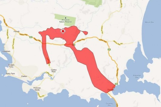 Forcett Fire Map (Friday, 4th January 2013)
[Source: ABC News website, ^http://www.abc.net.au/news/2013-01-04/forcett-fire-places-homes-at-risk/4453038]
.
Observations from the above TFS Forcett Fire Map:
.
1. The ignition source of the fire was north of the Arthur Highway along Inala Road (top left of above map). This places the TFS confirmed ‘burning stump’ midway along Inala Road, per juxtaposed mapping below.
.
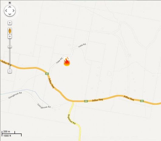 Deduced Ignition Location of the Forcett Fire
In the absence of TFS publicly confirming the exact location of the ‘burnt stump’ ignition source,
by deduction from the Forcett Fire Map above, the Inala Road ignition source appears midway along Inala Road, Forcett.
.
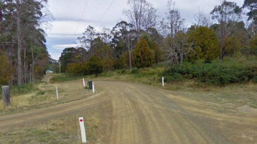 Inala Road
Where along Inala Road was the burning stump that re-ignited the Forcett Fire?
Ask the TFS.
It is incumbent upon the Tasmanian Fire Service to be transparent about the exact source loation of this fire so that the truth be known.
.
2. Consistent with the prevailing north-westerly windwind, the direction of this fire was that it initially headed easterly after re-igniting from the declared ‘burning stump‘ in the afternoon of Thursday 3rd January. Sometime in the evening of the 3rd January the wind reverted to the prevailing direction from the north-west and thereafter continued consistently from this direction through the couyrse of the following two weeks into the Forestier Peninsula.
.
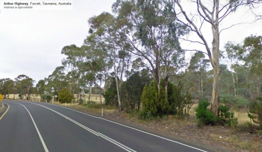 Open farmland along Arthur Highway, near the Inala Road intersection
looking south east toward Dunalley
Open farmland along Arthur Highway, near the Inala Road intersection
looking south east toward DunalleyClick image to enlarge [Source: Google Maps, March 2010] .
3. The separate strip of fire burnt south along the Sugarloaf Road would appear to be specifically contained and so likely to be a deliberately lit control line/fire break defensively intended to prevent the main wildfire crossing the road in the event of a wind change to the east. This is conjecture in the absence of TFS public explanation on its website.
.
QUESTION 13:
.
What was the cause of the “old fire in a burnt out tree stump”. Lightning doesn’t usually light tree stumps; trees on ridges yes. But Inala Road is not on a ridge, so the lightning excuse is a convenient furphy. Was the fire a consequence of a farmer’s ‘pile burn’ or ‘burn off’? Who lit the fire?
Was the burn off authorised by the Tasmanian Fire Service? If so why, when it is summer and at a time of high bushfire risk? What investigations are being conducted by the TFS and/or Tasmanian Police into the original cause of the fire?
.
Jan 2013: Bushfire Conditions around Dunalley
.
Prevailing Wind
.
As the crow flies, Hobart Airport is about 12km from the ignition source that purportedly started the Forcett Fire near Inala Road, and Hobart Airport is about 25km from Dunalley.
The following wind rose chart of the Bureau of Meteorology shows that over the past half century, the prevailing wind for Hobart Airport is predominantly from the north-west. This may be generally extrapolated for the surrounding Sorrell local government area, including Forcett and Dunalley.
.
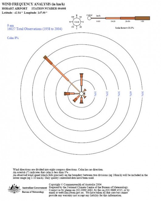 Average Wind at Hobart Airport (1958-2004)
This Wind Rose chart shows the prevailing wind predominantly being from the north-west at typically 10-20kph.
This was the wind at Forcett and Dunalley on 3 and 4 January 2013 – significantly nothing surprising!
Average Wind at Hobart Airport (1958-2004)
This Wind Rose chart shows the prevailing wind predominantly being from the north-west at typically 10-20kph.
This was the wind at Forcett and Dunalley on 3 and 4 January 2013 – significantly nothing surprising![Source: Australian Bureau of Meteorology, ^http://www.bom.gov.au/climate/averages/climatology/windroses/wr09/wrpdf/094008-9amAnnual.pdf, >Read Chart]
.
Significantly, the prevailing wind is a most relevant environmental factor in the Forcett Fire, because of the juxtaposition of Forcett to Dunalley.
The ignition source at Inala Road Forcett was north west of Dunalley, the same as the prevailing wind.
Wind typically increases in the early afternoon as the temperature differential between the hotter land mass and the nearby cooler sea strong maximises. This is referred to as a diurnal wind pattern. On Friday 4th January as temperatures soared, this wind was predictably due to increase and at around 2pm it did. The 15 km/h breeze increased to a recorded peak of 52km/h at 1.57pm.
So the Forcett Fire on 3rd January was predictably and reliably going to burn toward Dunalley. The diurnal wind pattern at the time was nothing extra-ordinary, and therefore would have been predictable.
.
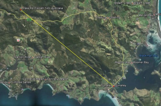 Ignition source at Inala Road, Forcett was 17km North West of Dunalley
Click image to enlarge
[Source: Google Earth]
.
QUESTION 14:
.
Given that a light north west prevailing breeze was predictably fanning the Forcett Bushfire toward Dunalley in the afternoon and evening of 3rd January, what firefighting response including backburning was undertaken to prevent the Forcett Bushfire’s spread south east toward Dunalley?
.
All Thursday afternoon, through Thursday night and all Friday morning the observed wind was relatively light. The following account is poignant:
“A couple of kilometres just off the Arthur Highway at Fazackerlys Rd, a small group of farm workers, some locals and a police officer watched from a safe distance the fire which had burned slowly all morning in the wooded hillsides to the north. The smoke rose straight up from several large and small outbreaks burning around farmland.”
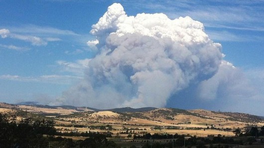
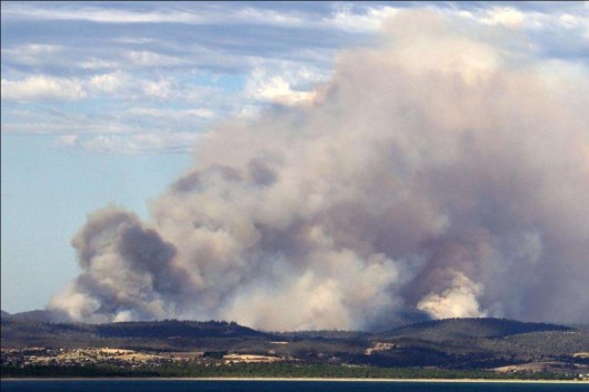 The Forcett Fire on the afternoon of Thursday 3rd January 2013
Burning out of control south of the Arthur Highway heading right (south east)
Low winds meant it was not a fast moving firestorm at this stage.
View across Frederick Henry Bay looking north-east, perhaps Bally Park/Carlton settlement in the foreground.
(Photo by Ian Stewart, 20130103, click image to enlarge)
.
So, the Forcett Fire on the morning of Friday 4th January was still slowing burning through relatively accessible farmland under light wind conditions. Why wasn’t it extinguished?
.
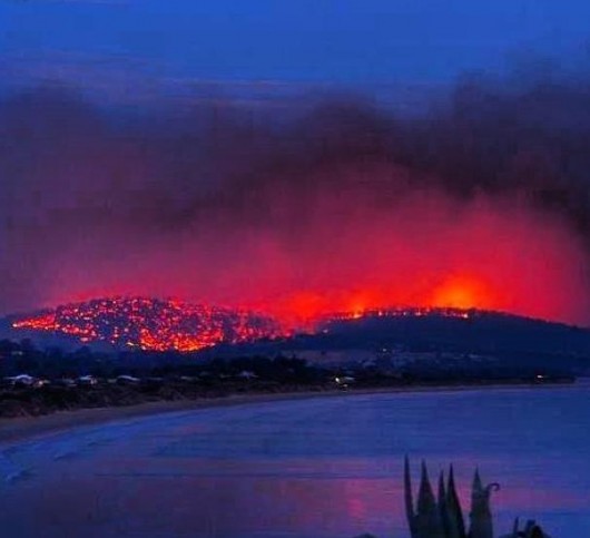 Forcett Bushfire
(Photo by Moemahfoudh, 20130104)
.
QUESTION 15:
.
Given that the Forcett Fire was still declared uncontained by the Tasmanian Fire Service in the morning of Friday 4th Jaunary, what addition emergency bushfire response measures were implemented by the TFS to prevent the fire impacting Dunalley?
Did the Bureau of Meteorology publicise forecast increased wind speed and the extreme temperature for 4th January on the 3rd January? What Fire Danger Index was forecast by the TFS for 4th January for the ongoing Forcett Fire and was it not clear to the TFS that the risk to Dunalley and Boomer Bay from the Forcett Fire was catastrophic?
.
The 2pm Diurnal Wind
.
…and then the wind came up…at Fazackerlys Rd just after 2pm, all hell broke loose. The fire had taken a run.
As the Forcett Bushfire impacted Dunalley at around 2pm on 4th January, recorded wind gust reached 80km/h, driving the fire south into Dunalley at unstoppable speed.
Bushfires are known to fan their own wind. According to the CSIRO, bushfires can generate their own wind. “Strong convection set up by the heat of the fire creates an in-draw wind that can interact with the prevailing wind. Depending on the direction of the prevailing wind and the location of the fire, this in-draw wind may increase or decrease the strength of the prevailing wind.”
[Source: Fire Generating Wind, ^http://www.csiro.au/en/Outcomes/Safeguarding-Australia/FireGeneratedWind.aspx].
High Temperatures
.
On 4th January 2013, maximum temperature records were broken at eight weather stations across Tasmania. Hobart reached 41.8°C, breaking the previous temperature record by 1°C.
However, as explained above, these extreme temperatures although technically breaking records, were only doing so by marginal degrees on the 3rd January. Tasmania had recorded similar extreme hot summer temperatures on at least seven previously documented occasions. So, despite media sensationalism and the vested interest of the Australian Government’s climate change commission to claim justification for its government-dependent revenue, by no means were the temperatures of January 2013 unprecedented, or ‘off the scale‘.
Yes, it was forecast to be an unusually very hot dry summer for Tasmania, no more no less.
Read Climate Commission report: >’Off the charts: Extreme Australian summer heat‘
[Source: Climate Commission, Australian Government, ^http://climatecommission.gov.au/wp-content/uploads/CC_Jan_2013_Heatwave4.pdf].
The Bureau of Metorology has published the maximum daily temperatures for Australia, including Tasmania, through January shown by colour as follows.
Click on the image and see the changing temperatures specific to Tasmania:
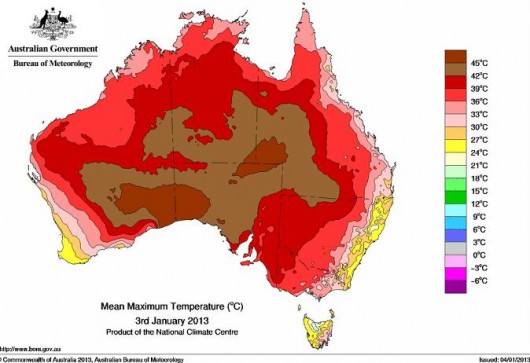 Australia’s maximum temperature mapping through January 2013
Click image to show dynamic progress
Note Tasmania on 3rd January was still in the 30s.
[Source: Australian Bureau of Meteorology,
^http://www.bom.gov.au/web03/ncc/www/awap/temperature/maxave/daily/colour/latest.loop.gif]
.
Specific to Dunalley, according to its local BOM weather station, the temperatures for January 2013 read as follows.
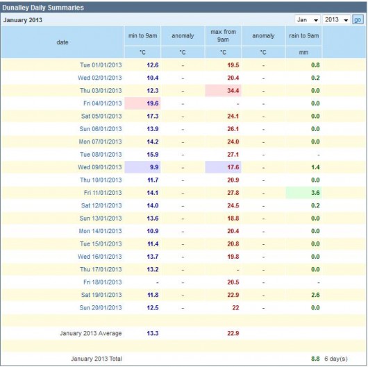 [Source: ^http://weather.ninemsn.com.au/station.jsp?lt=site&lc=94254&list=ds]
.
Significantly, Thursday 3rd January 2013 peaked at a very high 34.4 Celsius. The maximum on the following critical day Friday 4th January is not recorded. This is likely due to the Dunalley gauge reader being otherwise pre-occupied escaping from the impacting bushfire.
Anecdotally the mid afternoon temperature spiked at 40.2 Celsius at around 2pm that day, and about a kilometre south-west the Stroud Point weather station registered 54.9 Celsius at a time not disclosed – perhaps between 2:30pm and 3pm that day.
[Source: ‘From spark to raging inferno’, 20130113, by David Killick in The Sunday Tasmanian. See extract below].
QUESTION 16:
.
Given the pre-existing bushfires across the State causing concern, the forecast bushfire conditions, the known prevailing NW wind across the Sorrell Council area (Forcett – Dunalley) what special bushfire emergency response measures did the Tasmanian Fire Service take critically on 3rd January 2013, on being alerted to the Inala Road ignition to prevent the fire spreading? Why was the fire not contained on the 3rd January, while it was in accessible farmland, before it advanced slowly into hilly less accessible timbered State reserves toward Dunalley?
.
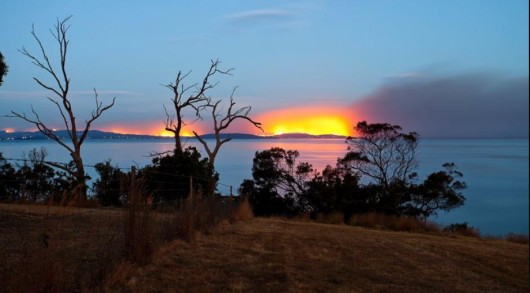 Forcett Fire approaching Dunalley and Boomer Bay
[© Photo by Michael Gay Photography, 20130103]
.
So the following article extract provides the best light on what happened on the Friday, 4th January 2013 at Forcett:
.
‘From spark to raging inferno’
by David Killick
.
<<IT only takes a spark to start a fire.
At Inala Rd near the south- eastern Tasmanian town of Forcett, that spark is believed to have been struck some time before Christmas.
A landowner was clearing a tree stump the old fashioned way by burning it out. They thought the fire was out, but it smouldered unchecked in the root system for two weeks, before flaring and dooming a town.
The morning of Friday January 4, 2013, was unremarkable in Dunalley.
It was warm and still.
If anything it was perhaps a little quieter than normal.
The heat and the fire risk warning encouraged some people to leave and traffic through the town was light despite the school holidays.
Inside the weather station by the water at Stroud Point, the temperature ticked over the 30C mark just before midday.
At the Dunalley Fish Market in Fulham Rd, tourists and families stopped to eat their lunches.
Along Marion Bay Rd at nearby Copping, many residents seemed to have taken the advice of fire authorities and left.
Local shopkeeper Kate North was concerned, but not overly so.
“If the wind doesn’t come up we should be OK,’’ she said. “The problem will be if it gets into the bush and heads towards Dunalley.’’
A couple of kilometres just off the Arthur Highway at Fazackerlys Rd, a small group of farm workers, some locals and a police officer watched from a safe distance the fire which had burned slowly all morning in the wooded hillsides to the north.
The smoke rose straight up from several large and small outbreaks burning around farmland.
.
And then the wind came up
.
And then the wind came up. At 1.43pm, give or take a minute either side, a wall of flame suddenly emerged above the treetops, leaping into the air, 20 or 30 metres high.
Burning embers began to rain down. The south-easterly wind had swung west. The gust that fanned the fire hit Dunalley 8km away at 1.57pm at 52km/h. The temperature spiked 5C in six minutes to 40.2C.
There is an unholy trinity that keeps bushfire fighters awake at night. High temperatures, strong winds and low humidity.
Add heavy fuel loads and a source of ignition, and there is no force of man that can stop a bushfire.
The 2009 Victorian fires which killed 173 people have seared the word “catastrophic’’ into the popular lexicon the fire danger beyond “extreme’‘.
These were the conditions that existed in the hills north of Dunalley.
As one man put it, conditions on January 4 were unlike anything Tasmania has seen since 1967.
“I’ve been a firefighter for 35 years. I have never seen a fire so destructive as that was on Friday,” he said.
“On a day like that you cannot fight a fire. It doesn’t matter how much water or how many helicopters you have.’”
AT Fazackerlys Rd just after 2pm, all hell broke loose. The fire had taken a run. All of a sudden four houses and their outbuildings were surrounded by the flames.
The Tasmania Fire Service crews raced from outbreak to outbreak, saving what they could.
Local Todd Hildyard had been on a bulldozer several hundred metres away.
He raced the flames to his back steps and with a hose and the help of his teenage son somehow stopped the home going up.
“We were bloody lucky – she was awful close to getting in here,” Mr Hildyard said.
Another group fought a desperate battle just up the road.
Although a house near the highway was saved, one by one the flames claimed sheds and outbuildings.
The beautiful old hay shed by the highway went up.
Less than a kilometre away at the top of a hill above Copping, John Yaxley was fighting an astonishing battle to save his place surrounded by bush, most of it ablaze.
Somehow he saved his home and a shed with $60,000 worth of wine inside, but his parents’ grand pentagon-shaped hilltop house was lost, as was the caretaker’s home.
Locals watched helpless from the shade outside Kate North’s shop at Copping.
Amid the light grey smoke of burning bush could be seen the terrible dark smoke of people’s homes going up in flames.
One older man watched his home burn.
“I saw it catch fire, I knew where to look and I thought `any moment now’ and it went up. There’s a lot of nice things gone but that is the way of the world. It’s a devil of a thing.”
The fire rolled down the ridgetops to Marshton Lane.
In a hurried roadside conference as the flames raged around, the firefighters knew the task was already too great.
Getting in front of this fire would be an act of suicide.
“Guys, it’s all turned to shit,” said one.
Those there say that just after 3pm the hellfire rolled over the hill behind the golf course like a storm.
A terrifying black, red and purple wall of flames.
Smoke darkened the sky.
Helicopter pilot Ben Brolewicz watched from above.
“It was probably as bad as it gets. With all of the heat that it generated it created a sort of a vortex that picked stuff up and flung it through the air,’’ he said in an interview with the ABC.
Bryan Webster called it a “tsunami of fire”.
With his partner Fiona Hills and her 11-year-old son Darcy Scott, Mr Webster fled to the water’s edge as the fire roared into town.
The family sheltered in the water for two hours with a mob of terrified wallabies for company.
At another jetty, another miraculous escape.
The Holmes family, grandma, grandpa and five grandchildren in their care fled the flames and sought shelter.
A haunting snapshot taken of them sheltering in the water has become the iconic image of these fires worldwide.
The family were calm, but huddled and prayed. Not one was harmed.
Josh Clements’ home was saved. His parents weren’t so lucky. He and his family pushed a boat out into the canal as the front hit and floated in the bay for several hours.
Hundreds of metres from the burning town, the Stroud Point weather station registered 54.9C.
The wind by now was gusting to 80km/h, driving the fire to the south.
The school went up, as did the police station, the bakery and many homes.
But somehow not a single life was lost.
Those who were not in the water were shepherded by police to the local pub to shelter – a move that saved scores of lives.
AS Dunalley burned, the fire spread left and right, from its formerly narrow front.
The eastern edge moved into Boomer Bay – a pretty community of waterfront shacks.
Just after 4pm, Steve Fisher and several dozen other locals watched as the fire approached steadily through knee-high grass.
“We’ll stick with it as long as we can,” he said calmly.
At that moment, just a few hundred metres away to the south, dozens of people were fighting for their homes and their lives.
Simon and Tully Brooks tried to fight the grassfire as it approached.
The father and son attacked with buckets and hoses, but their house went up.
They knew it was hopeless. They grabbed what valuables they could and fled.
Lex Johnson saw his neighbours run for their lives. “I was up at the corner when it circled around the back and through the trees behind our property,” he said.
“And then we saw the people from down the road running to get away from the fire . . . and it was catching up to them.”
Those cut off by the fires fled to the jetty where many were saved by the bravery of a helicopter crew.
The crew of paramedics returned over and over in thick smoke and plucked people from the water including a pregnant woman and five dogs.
On a point just east of Dunalley, not far from the weather station, it was helicopters too that saved the Jenkins family.
Ten members of the family had moved their caravans and cars to the water’s edge as the fire burst over the nearby hills.
As the flames drew close, a helicopter appeared and doused the family again and again until the threat had passed by.
Further north, at Connellys Marsh the battle would rage through the night.
Cut off from all outside help, neighbours banded together to keep each other safe.
A flotilla of small boats ferried away those who wanted to leave and then those who stayed faced the flames.
Martin Thorpe returned to watch the shack his family had cherished for 30 years, razed by the fire.
GRAEME Grundy dragged a neighbour to safety then fought with Mr Thorpe to save his own place – in part thanks to a water pipe that burst at just the right moment, showering the place with the remaining water from his 1000-gallon tank.
When the sun rose, the seaside hamlet was dotted with small clearings filled with smouldering ruins.
Somehow, more homes were saved than lost.
As the survivors contemplated their extraordinary night, the fires delivered one last cruel blow. The last home to be lost at Connellys Marsh went up around 8am.
The Inala Rd fire caused more havoc and destroyed more homes and continues to burn in spots south of Eaglehawk Neck, but most of the damage took place in about three hectic hours.
An inquiry will determine how – against all odds – not a single human life was lost or a serious injury sustained that Friday. Fire chiefs say there has been much planning and many lessons learnt from Black Saturday in Victoria in 2009. After such horrific losses as Victoria’s, people are far more aware of the risk of fire.
And communications have improved since then too. The hundreds of broadcast alerts, website updates and urgent text messages played their part.
And there was some luck. The area was surrounded by water which gave so many a place to run to when it all became too much.
But summer is not over yet. After a long dry spell, huge tracts of the Tasmanian bush are loaded with fuel.
The peak of our fire season is still weeks away. As hard as it is to believe, the worst may not yet have passed.>>
.
[Source: ‘From spark to raging inferno’, 20130113, by David Killick, in The Sunday Tasmanian (not published on the Internet), but reproduced in the Tasmanian Times; additional reporting by Zara Dawtrey, Matt Smith, Bruce Mounster, Blair Richards, Linda Smith, and Tim Martain, posted by PB 20130115, ^http://tasmaniantimes.com/index.php?/weblog/article/the-new-normal/show_comments].
Hindsight Local Reflections
.
Most of the bushland that the bushfire burnt through before impacting Dunalley was privately owned.
Locals in the Tasmanian fishing village of Dunalley say the fire which ravaged their community would not have been so ferocious if hazard reduction burns had been carried out before the summer.
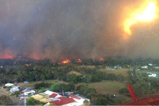 A massive fireball bears down on Dunalley on Friday.
The Dunalley Primary School in the foreground would be soon destroyed.
[Source: Photo by Michael Goldsmith, Tasmania Fire Service,
^http://www.abc.net.au/news/2013-01-10/fireball-2jpg/4459102]
.
A total of 126 properties were destroyed or damaged in the Dunalley fire, and a photo (above) given to the ABC yesterday and taken from a fire-fighting helicopter shows a giant fireball bearing down on the town at the height of the inferno.
.
The following audio is hindsight feedback from local residents of Dunalley and the immediate surrounding area, about their citizen lay views about what could have been done to prevent Dunalley burning.
.
Audio: Listen to Felicity Ogilvie’s report (ABC Radio News, AM Programme, 20130110):
.
One resident who still has a home is oyster farmer Justin Gock.
“I believe that if you’ve got people living in areas where there’s substantial forests, there should be significant management plans in place to control situations like this,” he said.
“Because if these areas were back-burned like they used to and the infrastructure was in place, fair chance it might not have happened.”
Tony Disipio, who lost his house in the blaze, is critical about the lack of preventative burns around Dunalley.
“Well 25 years ago they used to burn off regularly around the hills, it was like a winter thing, a winter exercise,” he said.
“And I noticed over the years that there was just less and less of it.”
Homes damaged by bushfire seen from above between Dunalley and Boomer Bay, Tasmania Photo: A total of 126 properties were destroyed or damaged in the Dunalley fire. (AAP
Farmer Sandy Gray has also noticed that preventative burns have been declining in recent times.
“In the old days, they used to go around and just quietly do a few, especially on the northern, north-western sides of the townships like Dunalley. It’s a pity they don’t still do it,” he said.
The State Government and Fire Service are promising to review their policies on controlled burns, but with fire warnings still current for parts of the state, they say they will wait until the current crisis is over.
The Tasmanian Fire Service’s Deputy Chief Officer, Gavin Freeman, says there has been no reduction in preventative burn-offs near Dunalley.
“I don’t believe there has been less done. You can always look back with a bit of hindsight and say yes, we could do more perhaps,” he said.
“But until we get these fires under control and are able to look back and do a proper analysis of where the fires have burnt to and what they burnt through – and bear in mind, under catastrophic conditions – we don’t really know whether that field reduction burning would be a benefit or not.”
The fire service may do some burn-offs, but the responsibility for preparing for a bushfire lies with the land owner.
At Dunalley it appears most of the bushland the fire tore through is privately owned.
The Tasmanian Minister for Emergency Management, David O’Byrne, says public land accounts for 20 per cent of the area affected by the fire.
“Fuel reduction and that sort of management is a joint responsibility between government, in terms of our land and in the parks land, but also in the private land that is around Tasmania,” he said.
“It’s important we have a community conversation around this. Now is not the time for that conversation, we need to get these fires under control.
“Once we can assess the impact of the fuel loads around… we can have a discussion on the basis of fact and reality as opposed to people’s pretty raw emotions at the moment.”
.
[Source: ‘Dunalley locals question control-burning regime’, by Felicity Ogilvie, AM Programme, Thu Jan 10, 2013, ^http://www.abc.net.au/news/2013-01-10/dunalley-locals-question-fire-prevention-strategies/4459040].
.
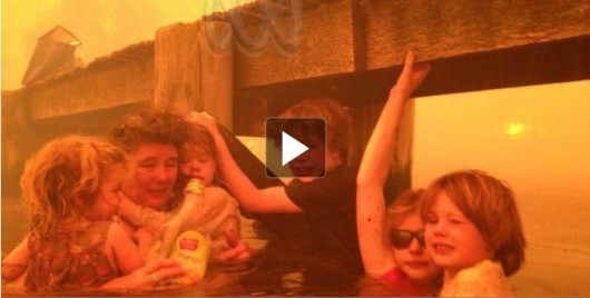 Video: Dunalley family’s amazing story of survival (ABC 7.30 Report)
(Click image to replay ABC News report)
.
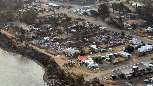 65 homes lost in Dunalley, and others lost in nearby Boomer Bay and Copping
