Hazard Reduction is wood smoke pollution
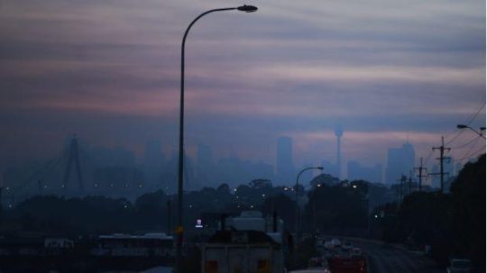
Monday, August 14th, 2017The entire Sydney basin is currently blanketed by thick smoke haze as this photo by Nick Moir in the Sydney Morning Herald today shows. The source of the smoke is trees burning in native bushland south and west of Sydney, this time specifically in at Ripple Creek near Warragamba Dam and the Bargo State Conservation Area south of Picton.
“Bargo State Conservation Area is a great place in NSW Southern Highlands for birdwatching, hiking, and swimming at Little River or Moore Creek.”
But not at this moment, it has been burned out.
The government-tasked arsonists call it “hazard reduction”, because they see native forest only as a hazard. So in the off season, that is outside the “bushfire season, government arsonists set fire to forest habitat to justify their existence. They choose a time when the weather is calm and there is a cold air inversion layer so that the smoke is trapped at ground level and lingers around longer.
This year, because there hasn’t been much rain over winter, the Rural Fire Starters (RFS) and their Victorian counterparts the Country Fire Arsonists (CFA) plan to commence their Bushfire Season early.
Proudly on its Facebook page the RFS boats “almost 100 hazard reduction burns are scheduled to take place in the coming week, weather permitting.”
Why?
“Hazard reduction burns are part of a planned bush fire fuel reduction designed to protect life and property from intense wildfires. These are important controlled burns which will reduce the risk to people and properties from bush fires.” And to back up their rationale, the RFS calls on Professor Ross Bradstock of the University of Wollongong to support them. Not surprisingly, Professor Bradstock believes warm temperatures and low rainfall indicate the state should brace for a “significant” bushfire season.
Professor Ross Bradstock’s self-appointed Centre for Environmental Risk Management of Bushfires at the university gets funded out of the RFS annual budget. Why would he not wish to encourage a fully engaged RFS in the off season and on season?
Such wanton destruction of remnant wildlife habitat doesn’t stop the annual bushfire destruction during the ‘on season’. It’s just that the naming is different – “hazard reduction” becomes “bushfire”. In fact most wildfires are caused either by escaped hazard reductions or over enthusiastic head burning to counter a wildfire front , but the head burn then becomes the wildfire. Most RFS trucks use petrol to start fires than water to put fire out. The cultural motto is ‘Burn it before it burns, it’s only bush’. It is a culture of bush arson.
A full list of planned bush arson was posted on the RFS website covering the state of New South Wales (this list is reproduced at end of this article).
Is it no wonder that Australia leads the world in wildlife extinctions and threatened species?
Bushfire is a threatening process, more so when it is widespread which is what hazard reduction sets out to achieve. A threat may be listed as a key threatening process under the NSW Threatened Species Conservation Act 1995 if it adversely affects threatened species, populations or ecological communities, or could cause species, populations or ecological communities to become threatened. Fire kills wildlife.
Yet there is no independent ecological assessment of target burns, no thought given to ecologically threatened populations of flora and fauna, or to threatened ecological communities, to critical habitats or to endemic species.
In the entire state of New South Wales, the only locations officially declared “critical habitats” are that of Gould’s Petrel out in the distant Tasman Sea, the Little penguin population in in a secluded cove in Sydney’s North Harbour, Mitchell’s Rainforest Snail on tiny Stotts Island Nature Reserve in the Tweed River, and a remote grove of Wollemi Pines in the Blue Mountains, with no current draft recommendations being considered.
In the Blue Mountains west of Sydney, with the direction of the custodian, the National Parks and Wildlife Service, over the weekend arson crews set deliberately fire “West of Warragamba Dam” inside the Greater Blue Mountains World Heritage Area. This area is called Kanangra Boyd National Park, an iconic wilderness gem within the World Heritage estate, was deliberately incinerated by the very government authority charged with its care and protection.
We know the real reason why this vast wilderness region was listed as the Greater Blue Mountains World Heritage Are on 29 November 2000 – a drinking water catchment for an ever growing Sydney.
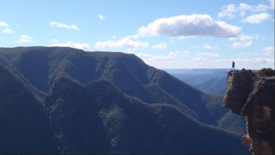 Kanangra Boyd National Park on a clear day
© Photo by Chris Rouen, ^https://isolateyourself.wordpress.com/tag/kanangra-boyd-national-park/
And so yesterday and today the thick smoke from the burnt forests has descended over Sydney. That strong smoky smell has everyone breathing in dead habitat.
Air quality in parts of Sydney have hit dangerous levels with health alerts for people with lung conditions and asthma.
And it’s as if no-one cares about pollution any more.
Toxicology of Smoke Inhalation
Wood smoke is harmful when breathed in and prolonged exposure can be carcinogenic. The airborne smoke particles vary in size from PM10 to PM25, which is a fine particulate matter each with a diameter between 1.0 and 2.5 micrometers, which is between 1% and 3% the diameter of a human hair. It means that wood smoke can be suspended in air and easily inhaled.
Wood Smoke emissions typically comprise the poisons carbon monoxide, nitrogen dioxide, sulphur dioxide, ozone, methane, dioxin, aldehydes (such as formaldehyde), particulate organic carbon, benzene, toluene, styrene, acid gases, napthalene, mould spores, ash particulate, volatile organic compounds and polycyclic aromatic hydrocarbons (PAHs), amongst others.
These are all a toxic cocktail to humans and animals alike. Fine particles in the air are able to travel deep into the respiratory tract and cause shortness of breath or worsen pre-existing medical conditions such as asthma. Woodsmoke exposure can depress the immune system and damage the layer of cells in the lungs that protect and cleanse the airways.
People who are exercising or doing an activity that causes them to breathe more rapidly and deeply are at a higher risk for health issues – including the volunteer firefighters sent in to do the damage. The long term health consequences can be serious and latent. Children, elderly people, others with pre-existing health conditions such as asthma, chronic bronchitis, and emphysema are also at a higher risk since they are more susceptible to the harmful effects of smoke inhalation. Long term exposure to air with particles has been associated with increases in risks for cancer, lung disease, and cardiovascular disease. Short term exposure typically only causes throat, eyes and nose irritation.
Carbon monoxide present in wood smoke can cause throbbing headaches, nausea and confusion. Twenty minutes of active burning may be required to develop sufficient concentrations of CO to reach lethal levels. But once exposed, 40 percent of those with severe poisonings will have long-term neurological impairment, including cognitive (emotional/behavior) dysfunction, short-term memory effects, and sensory motor (vision) problems.
Mix wood smoke in with exhaust fumes from traffic and industry and the dense smog can be lethal with prolonged exposure, such as currently in Sydney.
Wood smoke exposure’s long-term effects are less clear, and scientists say more study is needed. Firefighters are susceptible to “camp crud,” colds and viruses that attack immune systems. Wildfire-smoke exposure to mice has been linked to aggressive drops in blood pressure and may cause hardening of the arteries and development of plaque in the arteries.
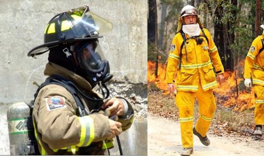
Firefighters can wear devices called dosimeters that detect high levels of carbon monoxide. Compare the safety kit the professionals receive to what the cheap volunteers have to put up with.
Wood heaters have been phased out because of the polluting adverse health effects of wood smoke. But hazard reduction is wood smoke on steroids; government sanctioned. Are they trying to kills us?
The RFS and CFA pompously dismiss public smoke inhalation concerns saying “consult your asthma action plan”. It’s the same cop out as them saying “trigger your bushfire survival plan.” They seem to presume this relinquishes government’s responsibility another notch. The first notch being government hiding behind volunteers, thinking by doing so somehow provides government with impunity from its emergency performance accountability and public criticism. Image if that attitude was used in the real professional emergency services like police and ambulance. Would we be told “trigger your home defence”, “take the law into your own hands”, and “trigger your first aid kit”?
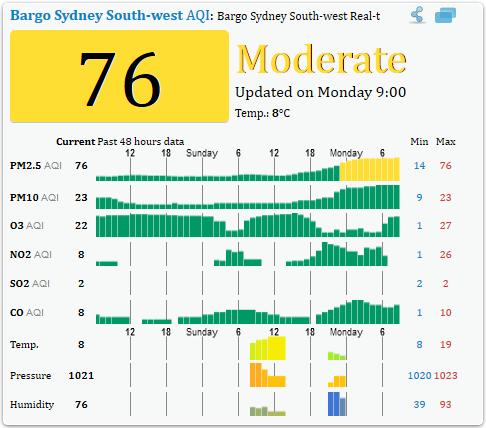
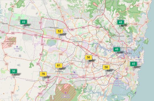 Air Quality Index of Sydney today
Source: Beijing based group, Air Quality Index China, ^http://aqicn.org/city/sydney/
The following Air Quality Index chart for Bargo shows the heightened air pollution on Monday 14th August 2017, caused predominantly by the government’s hazard reduction activities. Note the pollutants shown being O3 (ground level ozone), NO2 (nitrogen dioxide), SO2 (sulfur dioxide), and CO (carbon monoxide).
Where are those concerned about greenhouse gas emissions?
There seems to be this culturally higher ideal of mitigating bushfire risk which entails burning forest habitat in case it burns.
Hazard Reduction Advisory for 10th August 2017 to 18th August 2017
Source: ^http://www.rfs.nsw.gov.au/fire-information/hazard-reductions
The following hazard reduction burns are planned by NSW land managers (such as National Parks and Wildlife Service, Forestry Corporation NSW, Crown Lands and Local Government Authorities) and fire agencies (NSW Rural Fire Service and Fire and Rescue NSW) over coming days, weather permitting.
| Due datesort | LGA | Location | Tenure | HR by |
|---|---|---|---|---|
| 10/08/2017 to 10/08/2017 | Cootamundra-Gundagai | Rail Corridor Dirnaseer Road to Olympic Highway, Cootamundra | Australian Rail Track Corporation | Rural Fire Service |
| 10/08/2017 to 10/08/2017 | MidCoast | Bushland between Follies Road and Warwibo Creek Trail, Khappinghat National Park, Old Bar | NSW National Parks & Wildlife Service | NSW National Parks & Wildlife Service |
| 10/08/2017 to 10/08/2017 | Kyogle | Thompsons Road, Cawongla | Private | Private |
| 10/08/2017 to 10/08/2017 | Port Stephens | North of Dowling Street, Nelson Bal | Department of Primary Industries (Crown Lands) | Fire & Rescue NSW |
| 10/08/2017 to 10/08/2017 | Lake Macquarie | In the vicinity of Eucalypt Close and Summerhill Drive, Wangi Wangi | Local Government Authority, Private | Fire & Rescue NSW |
| 10/08/2017 to 11/08/2017 | Clarence Valley | In the vicinity of Riverbend Road, Kungala | Private | Rural Fire Service |
| 10/08/2017 to 12/08/2017 | MidCoast | Oak Lane, Shallow Bay | Private | Rural Fire Service |
| 10/08/2017 to 12/08/2017 | Kyogle | In the vicinity of Cattle Camp Road, Richmond Range National Park | NSW National Parks & Wildlife Service | NSW National Parks & Wildlife Service |
| 10/08/2017 to 16/08/2017 | Clarence Valley | Bushland between between Northern Boundary Trail and Centre Road, Yuraygir National Park | NSW National Parks & Wildlife Service | NSW National Parks & Wildlife Service |
| 10/08/2017 to 16/08/2017 | Clarence Valley | Bushland between between Centre Road and Through Road, Yuraygir National Park | NSW National Parks & Wildlife Service | NSW National Parks & Wildlife Service |
| 11/08/2017 to 11/08/2017 | Clarence Valley | West of Fortis Creek Road, Fortis Creek | Private | NSW National Parks & Wildlife Service, Rural Fire Service |
| 11/08/2017 to 11/08/2017 | Central Coast | Peats Ridge Road, Peats Ridge | Private | Private, Rural Fire Service |
| 11/08/2017 to 11/08/2017 | Gunnedah | Black Jack State Forest, Gunnedah | Forests NSW | Forest Corporation of NSW |
| 11/08/2017 to 14/08/2017 | Richmond Valley | Bushland between The Gap Road and South Gate Road, Bundjalung National Park | NSW National Parks & Wildlife Service | NSW National Parks & Wildlife Service |
| 11/08/2017 to 12/08/2017 | MidCoast | Bushland west of Eastern Fire Road and Palmers Trail, Khappinghat Nature Reserve, Wallabi Point | NSW National Parks & Wildlife Service | NSW National Parks & Wildlife Service |
| 11/08/2017 to 13/08/2017 | Port Macquarie-Hastings | South of Honeysuckle Road, Bonny Hills | Local Government Authority | Local Government Authority, Rural Fire Service |
| 12/08/2017 to 12/08/2017 | Bellingen | McDougall Place, Fernmount | Private | Private, Rural Fire Service |
| 12/08/2017 to 12/08/2017 | Campbelltown | Corner of Victoria Road and Katanna Road, Wedderburn | Private | Private, Rural Fire Service |
| 12/08/2017 to 12/08/2017 | Coffs Harbour | Old Coast Road, Korora | Private | Private, Rural Fire Service |
| 12/08/2017 to 12/08/2017 | Hornsby | Bushland between Peebles Road and Ben Bullen Road, Glenorie | Department of Primary Industries (Crown Lands) | Rural Fire Service |
| 12/08/2017 to 12/08/2017 | Inverell | Corner of Taylor Ave and Yetman Road, Inverell | Private | Private, Rural Fire Service |
| 12/08/2017 to 12/08/2017 | Lismore | Fernside Road, Fernside | Private | Private |
| 12/08/2017 to 12/08/2017 | The Hills | Bushland north of Dargle Trail, Lower Portland | Private | Rural Fire Service |
| 12/08/2017 to 12/08/2017 | Warrumbungle | Hawkins Lane, Coonabarabran | Local Government Authority | Private |
| 12/08/2017 to 13/08/2017 | Lake Macquarie | Bushland north of Kimbul Road and west of Porowi Road, Brightwaters | Department of Primary Industries (Crown Lands) | Rural Fire Service |
| 12/08/2017 to 13/08/2017 | Lake Macquarie | In the vicinity of Park Street and Westcroft Street, Killingworth | Local Government Authority | Fire & Rescue NSW, Rural Fire Service |
| 12/08/2017 to 13/08/2017 | Lake Macquarie | Bushland south Of Sackville Street, Killingworth | Private | Rural Fire Service |
| 12/08/2017 to 13/08/2017 | Northern Beaches | West of Namba Road, Duffys Forest | Other | Rural Fire Service |
| 12/08/2017 to 13/08/2017 | Wollondilly | Bushland south of Scroggies Road, Lakesland | Private | Rural Fire Service |
| 12/08/2017 to 13/08/2017 | Wollongong | Between Princes Motorway and Pinces Highway, Helensburgh | Private | Catchment Authority, Fire & Rescue NSW, Rural Fire Service |
| 12/08/2017 to 13/08/2017 | Penrith | In the vicinity of Mayfair Road, Henry Cox Drive, west of Mulgoa Road, Mulgoa | Private | Rural Fire Service |
| 12/08/2017 to 14/08/2017 | Wingecarribee | Bushland in the vicinity of Sackville Street Fire Trail, Hill Top | Private | NSW National Parks & Wildlife Service, Rural Fire Service |
| 12/08/2017 to 22/08/2017 | Lismore | Fox Road, Rosebank | Private | Private, Rural Fire Service |
| 12/08/2017 to 12/08/2017 | Penrith | Carrington Road, Londonderry | Private | Rural Fire Service |
| 13/08/2017 to 13/08/2017 | Bellingen | South of McDougall Place, Fernmount | Private | Private, Rural Fire Service |
| 13/08/2017 to 13/08/2017 | Coffs Harbour | Dairyville Road, Upper Orara | Private | Private, Rural Fire Service |
| 13/08/2017 to 13/08/2017 | Coffs Harbour | Lower Bobo Road, Ulong | Private | Private, Rural Fire Service |
| 13/08/2017 to 13/08/2017 | Clarence Valley | Boundary Road, Kremos | Private | Rural Fire Service |
| 13/08/2017 to 13/08/2017 | Central Coast | Kellynack Road, Mangrove Mountain | Private | Private, Rural Fire Service |
| 13/08/2017 to 13/08/2017 | Kempsey | Ridge Lane, Deep Creek | Private | Private, Rural Fire Service |
| 13/08/2017 to 13/08/2017 | Kyogle | Thompsons Road, Cawongla | Private | Private |
| 13/08/2017 to 13/08/2017 | Lismore | Pinchin Road, Goolmangar | Private | Private |
| 13/08/2017 to 13/08/2017 | Wollondilly | Bushland boarded by Ryan Street, Close Street, Campbell Street and Lakes Street, Thirlmere | Department of Primary Industries (Crown Lands) | Rural Fire Service |
| 13/08/2017 to 13/08/2017 | Wollondilly | Corner of Lakes Street and Campbell Street, Thirlmere | Department of Primary Industries (Crown Lands) | Rural Fire Service |
| 13/08/2017 to 13/08/2017 | Queanbeyan-Palerang | Tomboye Road, Tomboye | Private | Rural Fire Service |
| 13/08/2017 to 13/08/2017 | Queanbeyan-Palerang | Foxs Elbow Road, Warri | Private | Rural Fire Service |
| 13/08/2017 to 13/08/2017 | Tamworth | Goddard Lane, Westdale | Local Government Authority | Rural Fire Service |
| 13/08/2017 to 13/08/2017 | Shoalhave | Curvers Drive, Manyana | Private | Rural Fire Service |
| 13/08/2017 to 14/07/2017 | Wingecarribee | Bushland between Boilins Road Fire Trail and Wilson Drive, Balmoral | NSW National Parks & Wildlife Service | NSW National Parks & Wildlife Service, Rural Fire Service |
| 13/08/2017 to 14/08/2017 | Central Coast | South of the Pipeline Trail and west of Peats Ridge Road, Calga | NSW National Parks & Wildlife Service | NSW National Parks & Wildlife Service |
| 13/08/2017 to 15/07/2017 | Blue Mountains | West of Warragamba Dam, Blue Mountains National Park | NSW National Parks & Wildlife Service | NSW National Parks & Wildlife Service |
| 11/08/2017 to 11/08/2017 | Port Stephens | Bushland north of Aquatic Close, Salamander Bay | Local Government Authority, Private | Fire & Rescue NSW |
| 14/08/2017 to 14/08/2017 | Dungog | Parishs Road, Hilldale | Private | Private, Rural Fire Service |
| 14/08/2017 to 15/08/2017 | Wingecarribee | Sackville St, Hilltop | NSW National Parks & Wildlife Service | NSW National Parks & Wildlife Service |
| 14/08/2017 to 15/08/2017 | Ku-ring-gai | Bushland between Albert Drive and Fiddens Wharf Road, Lane Cove National Park, Killara | NSW National Parks & Wildlife Service | NSW National Parks & Wildlife Service |
| 14/08/2017 to 16/08/2017 | Wollondilly | Bushland between Macarthur Drive and Fire Trail No 12, Cataract | Catchment Authority | Catchment Authority |
| 14/08/2017 to 16/08/2017 | Sutherland | South of Sir Bretram Stevens Drive, Royal National Park | NSW National Parks & Wildlife Service | NSW National Parks & Wildlife Service |
| 14/08/2017 to 21/08/2017 | Tamworth | Back Kootingal Road, Nemingha | Private | Private, Rural Fire Service |
| 14/08/2017 to 23/08/2017 | Armidale Regional | Oxley Wild Rivers National Park, in the vicinity of Castle Doyle | NSW National Parks & Wildlife Service | NSW National Parks & Wildlife Service |
| 15/08/2017 to 15/08/2017 | Parramatta | Sophia Crescent, North Rocks | Local Government Authority | Fire & Rescue NSW |
| 15/08/2017 to 15/08/2017 | Dungog | Martins Creek Road, Paterson | Private | Private |
| 15/08/2017 to 15/08/2017 | Bellingen | Darkwood Road, Darkwood | Private | Private, Rural Fire Service |
| 15/08/2017 to 15/08/2017 | Coffs Harbour | In the vicinity of Heritage Drive and Pacific Highway, Moonee Beach | Private | Private, Rural Fire Service |
| 15/08/2017 to 15/08/2017 | The Hills | Bushland southwest of Sophia Crescent North Rocks | Other | Fire & Rescue NSW |
| 15/08/2017 to 16/08/2017 | Lake Macquarie | Burwood Road, Glenrock State Conservation Area, Kahibah | NSW National Parks & Wildlife Service | NSW National Parks & Wildlife Service |
| 15/08/2017 to 17/08/2017 | Mosman | Bradleys Head, Mosman | NSW National Parks & Wildlife Service | NSW National Parks & Wildlife Service |
| 15/08/2017 to 18/08/2017 | Kempsey | Bushland boarded by McIllwains Trail, New Tower Road and Power Line Trail, Kumbatine National Park, Kundabung | NSW National Parks & Wildlife Service | NSW National Parks & Wildlife Service |
| 15/08/2017 to 18/08/2017 | Wollongong | East of Princess Highway, Helensburg | Catchment Authority | Catchment Authority |
| 15/08/2017 to 19/08/2017 | Central Coast | East of Woy Woy Road and between Wattle Crescent and Gabagong Road, Phegans Bay | Private | Rural Fire Service |
| 15/08/2017 to 19/08/2017 | Central Coast | Bushland between Olive Street, Monastir Road, Phegans Bay | Local Government Authority | Rural Fire Service |
| 16/08/2017 to 16/08/2017 | Hawkesbury | Scheyville National Park, Maraylya | NSW National Parks & Wildlife Service | NSW National Parks & Wildlife Service, Rural Fire Service |
| 16/08/2017 to 16/08/2017 | Central Coast | Sydney Avenue, Umina | Local Government Authority | Fire & Rescue NSW |
| 16/08/2017 to 18/08/2017 | Wingecarribee | Nattai National Park, north of Wombeyan Caves Road, High Range | NSW National Parks & Wildlife Service | NSW National Parks & Wildlife Service, Rural Fire Service |
| 16/08/2017 to 18/08/2017 | Hawkesbury | Bushland between Drip Rock Trail and Bob Turners Trail, Colo Heights | NSW National Parks & Wildlife Service | NSW National Parks & Wildlife Service |
| 16/08/2017 to 18/08/2017 | Ku-ring-gai | Bushland east of Bobbin Head Road and south of the Sphinx Trail, Ku-ring-gai National Park, North Turramurra | NSW National Parks & Wildlife Service | NSW National Parks & Wildlife Service |
| 16/08/2017 to 19/08/2017 | Warrumbungle | East of Albert Wright Road, Garrawilla National Park, Rocky Glen | NSW National Parks & Wildlife Service | NSW National Parks & Wildlife Service |
| 17/08/2017 to 17/08/2017 | Coffs Harbour | North of Pine Road, Bindarri National Park | NSW National Parks & Wildlife Service | NSW National Parks & Wildlife Service |
| 17/08/2017 to 17/08/2017 | Cootamundra | Rail Corridor between Burley Griffin Way and Olympic Highway, Wallendbeen | Australian Rail Track Corporation | Private, Rural Fire Service |
| 18/08/2017 to 18/08/2017 | Armidale Regional | Old Gostwyck Road, Armidale | Private | Private, Rural Fire Service |
Further Reading:
.
[1] Wood Smoke Tables and Constituents, ^http://burningissues.org/car-www/science/table2.htm.
[2] Hazard Reductions, Rural Fire Service of New South Wales, ^http://www.rfs.nsw.gov.au/fire-information/hazard-reductions..
[3] ‘Toxicology of Smoke Inhalation‘, 20090801, by Gill Hall, Fire Engineering, America, ^http://www.fireengineering.com/articles/print/volume-162/issue-8/features/toxicology-of-smoke-inhalation.html.
[4] ‘Smoke and Ash Inhalation Related to Wildfires‘, 2012, by Kyla Young, Geology and Human Health course in the Department of Earth Sciences, Montana State University, ^https://serc.carleton.edu/NAGTWorkshops/health/case_studies/smoke_ash.html.
[5] ‘Effects of long-term smoke exposure on firefighters unclear‘, 20150905, The Seattle Times, America, ^http://www.seattletimes.com/seattle-news/northwest/effects-of-longterm-smoke-exposure-on-firefighters-unclear/.
[6] ‘Avoid wood smoke‘, Government of Canada, ^https://www.canada.ca/en/health-canada/services/air-quality/indoor-air-contaminants/avoid-wood-smoke.html