It’s Autumn in the Greater Blue Mountains, and the New South Wales Government’s bush arsonists are out in full swing deliberately setting fire to native habitat at every opportunity. Governmental ‘Habitat Reduction Season‘!
Is this pastime not comparable with the antiquated British imported tradition of the ‘Duck Season‘ – killing NATIVE ducks that is – just for sport. It’s the very same time of year!
“Capital climes for rough shooting old sport, what! Live on peg, we ought to bag a few dozen before tea.”
On Monday 25th March 2024, the NSW Government’s National Parks and Wildlife Service (NPWS) published a media release about its continuing “hazard” reduction burns across the Blue Mountains National Park. It read as follows (main extracts):
“The NSW National Parks and Wildlife Service (NPWS) has announced plans for an 850-hectare hazard reduction burn in the Glenbrook area of Blue Mountains National Park, set to commence on 26 March, weather conditions permitting. This preventive measure is part of a strategic effort to reduce the risk of wildfires and protect surrounding communities.
Scheduled to unfold over consecutive days, the operation targets the reduction of naturally accumulated fuel loads in the park. The primary aim is to provide strategic protection for the residential areas of Glenbrook, Lapstone, and Mulgoa against potential future wildfires.
…This burn is a component of the comprehensive hazard reduction program carried out by NPWS each year, often in collaboration with the Rural Fire Service and Fire and Rescue NSW. These operations are crucial for managing vegetation fuel loads and reducing the intensity and spread of potential wildfires.
The planned hazard reduction burns in Blue Mountains National Park underscore the ongoing commitment of NSW authorities to wildfire risk management and community safety. By taking proactive measures to manage fuel loads, the NPWS aims to mitigate the impact of wildfires, ensuring the protection of both natural landscapes and residential communities.”
Our comments to this bush arson justification spin doctoring:
The above is bush arson propaganda by contracted consultants with Communications Degrees, justifying the perpetual decimation of Australia’s native habitat since the first day of colonisation and usurpation of the continent since 1788. Nothing has changed or is likely to. Surviving intact wilderness has become reduced to mere islands. Just go to Google Maps [See our extract map below]
“850 hectares” is an area equivalent to about 30km x 30km (√ 850ha). In relative terms, that’s three times the size of Sydney’s CBD, a native habitat area capacity for many fauna;
“preventive measure is part of a strategic effort to reduce the risk of wildfires” – this is because when wildfires do occur the NSW Government invariably fails to (A) detect, (B) respond and (C) extinguish the ignitions promptly whilst small and controllable. It has an attitude that native habitat has a lower value than human habitat. In contrast, the urban Fire and Rescue Service is tasked to (B) respond and (C) extinguish the ignitions involving human property immediately, and unlike their unpaid volunteer Rural Fire Service (RFS) counterparts, they get paid to do it;
“protect surrounding communities” – this means human communities that have been built encroaching more and more into and usurping native habitat. These human “communities” are the only focus of the NPWS and its support RFS. Under this culture, wildlife communities matter not, irrespective of any threatened species impacted/killed. This attitude belies an antiquated anthropocentric mentality. Neither the NPWS nor the RFS employ an Ecologist. They just don’t care about protecting Ecology – in this case forest ecology;
“the operation targets the reduction of naturally accumulated fuel loads in the park“. That’s right, the NPWS as delegated custodial organisation ‘manager’ of the Blue Mountains National Park treats native habitat and its dependent fauna within such national parks in NSW (one of some 800) instead as “fuel loads” to be reduced to sterile urban park status. NPWS should be relegated to managing urban parks like Hyde Park in Sydney’s CBD;
“The primary aim is to provide strategic protection for the residential areas of Glenbrook, Lapstone, and Mulgoa against potential future wildfires.” – this is a reinforcement approach of our Point 3;
“…This burn is a component of the comprehensive hazard reduction program carried out by NPWS each year, often in collaboration with the Rural Fire Service and Fire and Rescue NSW.” – this is a reinforcement approach of our Point 3;
“These operations are crucial for managing vegetation fuel loads and reducing the intensity and spread of potential wildfires.” – “crucial” for whom? An expanding Sydney human housing sprawl? So the NSW Government’s volunteer and under-resourced RFS has less forested native habitat risk and so less work to do in the event of wildfires because year-on-year there is less forested native habitat left. Perpetuation that long term strategy, there will eventually be little or no native habitat left across NSW. So down the track a future NSW Government may well decide that the RFS is therefore no longer needed and so make the organisation redundant. Sydney that has been deliberately morphed by successive governments (state and federal) into the ‘Greater Sydney Region‘ has, on paper, swallowed whole the ‘Blue Mountains Region‘ (see NSW Planning map below) , presuming its world heritage status is now just outer-upper western Sydney parkland for the rezoning offing. Allowing the 2019 megafires to incinerate 80% of the Greater Blue Mountains World Heritage Area, clearly has achieved the NSW Government’s intended devaluation of the UNESCO recognised “Outstanding Universal Value” of all the Eucalypts, and is wholly consistent with a usurpation agenda for an even Greater Sydney megalopolis.
“The planned hazard reduction burns in Blue Mountains National Park underscore the ongoing commitment of NSW authorities to wildfire risk management and community safety. By taking proactive measures to manage fuel loads, the NPWS aims to mitigate the impact of wildfires, ensuring the protection of both natural landscapes and residential communities.” The spin doctoring clearly by outsourced consultants with Communication Degrees is palpable here. It’s more repetition of contrived persuasive terms: “planned hazard reduction burns”, underscore the “ongoing commitment of NSW authorities to wildfire risk management and community safety”. Ask the residents of Mount Wilson who lost their homes by RFS reckless arson in 2019 on this point! “taking proactive measures to manage fuel loads”, “the NPWS aims to mitigate the impact of wildfires”, “ensuring the protection of both natural landscapes and residential communities.” What so burning the natural landscapes to protect them? Seriously? In truth it is all about avoiding bad publicity when the RFS lights a high risk fire on 14th December 2014 causing homes to be incinerated like at Mount Wilson. “The state coroner has confirmed that a bushfire that destroyed homes in Mt Wilson, Mt Tomah, Berambing and Bilpin in December 2019 was caused after a planned RFS backburn jumped Mt Wilson Road.” [SOURCE: ‘Bushfire inquiry: Mt Wilson backburn to blame‘, BMG, 2nd April 2024]
RFS MOUNT WILSON ARSON: Sam Ramaci, like several of his neighbours, claims a back-burn lit by the RFS on December 14, 2019, was responsible for the destruction of his cool room, tractor and the property that was to fund his retirement. “If they hadn’t started the back-burn, my house would be still standing,” he said. (The NSW Government has refused to compensate him and others (nor even apologise) for the reckless misjudgment of its RFS – a NSW Government agency. Who can afford a class action? [Go to Video Link]
The Mount Wilson fire was the sixth backburn to escape along the southern containment line that was intended to protect the upper Blue Mountains from the Gospers Mountain Fire.
What sane person would join the Rural Fire Starters?
Bush arsonists have a psychological compulsion to set fire to see fire . It’s a ritual – they’re eyes light up. “Behold, The Fiery Cross !...”
NPWS is beholden to NSW Planning
A headline environmental protection agency that is supposed to be caring for national parks reporting to a state land use planning authority (aka Development). Is this a warped governmental portfolio conflict of interest of what? Liberal-Labor-Liberal…? Same Same.
The Regional Map of NSW according to the NSW Government’s Department of Planning and Environment fiefdom in 2024. Note that the Blue Mountains Region no longer exists, but has become annexed by the ever expanding ‘Greater Sydney Region’ in the mindset of Macquarie Street’s urban expansionism campaign. Mount Victoria a Sydney suburb now? Lookout Broken Hill!
Deforestation of Australia since colonisation and its usurpation from 1788. Remnant native forests and their native habitat have been decimated to ecologically unsustainable islands. The entire pre-colonial eastern seaboard of the continent was originally blanketed by native forests unbroken, extending about 600km inland. [SOURCE Google Maps – satellite view, April 2024]
It’s no wonder that Australia continues its record of perpetuating the world’s worst rate of wildlife extinctions. It’s akin to countries like Madagascar. It’s all hell bent on serving the Human Plague Order, currently 8.1 Billion! and in 2024 growing (and demanding more) by $75 million p.a. The current population of Australia is 26,654,200 as of Monday, April 29, 2024. Compare Australia’s Federation census of 1901 counted 3,773,801 people across Australia. [Check: Census Bureau Projects U.S. and World Populations on New Year’s Day; and ^https://www.worldometers.info/world-population/]
But wait there’s more bush arson planned…
An update last Friday, 26th April 2024 (just days ago), the NSW Government’s environmental department website again posted a media release advising of its further planned “Hazard reduction burn in Blue Mountains National Park” for the weekend.
It read as follows:
“The NSW National Parks and Wildlife Service (NPWS) with assistance from the NSW Rural Fire Service is conducting a hazard reduction burn in Blue Mountains National Park starting Sunday 28 April, weather permitting.
Staff from Metro South West and Blue Mountains regions undertaking the Pisgah Ridge hazard reduction burn near Glenbrook in the Blue Mountains National Park The hazard reduction burn will focus on an area south of Woodford, in the mid-mountains, and cover a total area of about 400 hectares. The burn aims to reduce fuel hazards and assist in the protection of property in the surrounding Woodford, Hazelbrook and Linden areas.
Fire trails around the burn area, including Bedford Creek, will be closed to the public, along with the Murphy’s Glen camping and day use area. The campground will be reopen when it is safe to do so.
Smoke may be seen in the area for up to a week after the initial operation.
The burn is one of many hazard reduction operations undertaken by NPWS each year, many with the assistance of the NSW Rural Fire Service (RFS) and Fire and Rescue NSW.
All burns around the state are coordinated with the NSW RFS to ensure the impact on the community is assessed at a regional level.
People with known health conditions can sign up to receive air quality reports, forecasts and alerts via email or SMS from the Department of Climate Change, Energy, the Environment and Water. For health information relating to smoke from bushfires and hazard reduction burns, visit NSW Health or Asthma Australia.
More information on hazard reduction activities is available at NSW Rural Fire Service and the NSW Government’s Hazards Near Me website and app.”
Asthma sufferers? – NSW Government care factor?
Carbon emissions? – NSW Government care factor?
10th December 2019: NPWS world heritage Eucalyptus woodsmoke enveloping Sydney from what started as an abandoned pile burn off Army Road near Gospers Mountain in the distant Wollemi NP two months prior on 26th October 2019. She’ll be right, eh NPWS boss David Crust?
The RFS is one of the planet’s highest emitters of airborne carbon particulates by way of causing mass wood-smoke by repeatedly lighting bushfires and ignoring wildfires. Wood smoke we feel is a tad more polluting than humans exhaling carbon dioxide. But then how many humans on the planet?
Yet the climate change cult remains quiet on this more serious global problem. Why so selective about a lesser pollutant in the hysterical ideology that has morphed from ‘Global Warming‘ (Wallace Smith Broecker’s term of 1975) to ‘The Greenhouse Effect‘ (Mike Hulme’s term in 1994) to ‘Climate Change Scientology‘ (U.S. National Academies of 2014) to currently ‘Climate Crisis‘ actually predating the former (U.S Vice President Al Gore of 2007).
The RFS and NPWS press on regardless – as it’s not carbon dioxide, so all good!
Here’s the latest bush arson schedule to further set fire to the still unburnt native habitat of the Blue Mountains:
RFS:“It’s ok love, it’s good for the bush. She’ll be right.”
It’s an age old mentality of the fox charged to look after the chickens. Both the NPWS and RFS have a cultural attitude that the national parks are NOT to be protected, despite the NPWS delegated to so-called manage NATIONAL parks across New South Wales (NSW). That is despite the Rural Fire Service (RFS) charged with putting out wildfires.
That perverted culture is conditioned to regard native habitat only as a ‘fuel’ that burns and so NOT habitat but a ‘hazard’ to be controlled and burned to prevent it burning. If there is no habitat left, then the meathead rationale, no hazard, so job done! Of recent times the spin doctors in government seconded as contractors with Communications Degrees (aka the art of spin) have softened the community sell of these ‘hazard reductions’ to ‘prescribed burns” to justify and take some noble authority from on high that the BUSH WAS ORDERED TO BE BURNED, WE HAVE NO CHOICE !
All their fire trucks are filled with more flammable liquids light a bushfire than water to put it out. ‘RFS’ should stand for for Rural Fire Starters.
Blue Mountains World Heritage?
Eventually the bush grows back but with a vastly different flora community make up. The biodiversity is gone. The wildlife don’t come back from the dead.
One of countless Koalas tragically burned to death in her native habitat during the Blue Mountains megafires of 2019. They won’t come back. [This website is not suitable for children to view]
This native Koala would have looked something like this:
National parks throughout Australia over the 236 years since colonisation and its continent-wide deforestation, land use destruction and introduced bushfires, have consistently and hatefully made Australia’s ecological landscape very very quiet and devoid of wildlife.
The 2019 mega bushfires of NSW that the NPWS and RFS let get out of control over months, wiped out 80% of the Greater Blue Mountains World Heritage Area, including rare remnant koala communities and hosts of other at-risk wildlife and their special native habitat that NPWS has no clue of the statistical losses. NPWS does not manage, it mismanages, else just oversees politically drive projects like multi-million dollar tourists track upgrades to benefit humans. The NSW State Government tasked to look after UNESCO world heritage on behalf of the Australia Government?
This habitat reduction regime is to burn the remaining 20% that didn’t cop the 2019 wildfire megablaze. They call this “stewardship”? All trust in the NSW Government to protect world heritage has long gone out the window.
The ‘NPWS’ is a misnomer
‘NPWS” is an abbreviation for the National Parks and Wildlife Service in the state of New South Wales.
Logo of the NPWS
The problem is that this government bureaucracy is supposed to be the governmental (public) custodian for national parks is misleading:
NPWS is not national, rather it is only a NSW governmental sub-department. Governmental ‘management’ of national parks is not national, rather each state and territory has its own national parks, and the Australian Government is not involved – so a bizarre and misleading naming tradition;
NPWS does NOT look after wildlife. Native habitat in these ‘national parks’ is supposed to be protected. Yet every year vast selected areas are burnt deliberately else left to burn on a grand scale, so killing wildlife and destroying their habitat.
As a consequence, the NPWS deserves to be more appropriately renamed as ‘NSW Parks Service‘ just like in Victoria, the Victorian Government calls its equivalent ‘Parks Victoria‘.
On the relevant NSW Government’s website pertaining to its NPWS, it explains that the NPWS is part of a sub-department called ‘Environment and Heritage, which in turn:
“Environment and Heritage is part of the Department of Climate Change, Energy, the Environment and Water.
Our vision is for a thriving, sustainable and resilient New South Wales.Environment and Heritage works with communities, businesses and governments to protect, preserve and strengthen the quality of our natural environment and heritage. We do this through active stewardship that supports a healthy New South Wales.We are committed to creating thriving environments, communities and economies that benefit the people of New South Wales.”
The three most trendy feel-good terms above include: “thriving”, “resilient” , active stewardship”. Pure motherhoodism by the contracted young spin doctors with a Communications Degree. So where are the published wildlife regional extinction stats before and after the Blue Mountains 2019 megablaze?
Recall Tathra Sunday 18 March 2018, the consequence of the RFS deliberately lighting a bushfire on a 38 degree Celsius (100 Fahrenheit) gusty day upwind of this coastal village. [Read Our Article: ‘Bushfire Scenario Was Not Rocket Science‘
[8] ‘Impact of the 2019-20 Mega-Fires on the Greater Blue Mountains World Heritage Area, New South Wales‘, 20221129, by P Smith and J Smith, Issue Vol. 144 (2022), Proceedings of the Linnean Society of New South Wales, ^https://openjournals.library.sydney.edu.au/LIN/article/view/17079
The Blue Mountains conservation grapevine has alerted Leura locals to a new development threat atop the Jamison Escarpment. It’s seems to be all about facilitating mass tourism and its coming from the custodial land holder itself, the so-called National Parks and Wildlife Service (NPWS).
Trust NPWS?
Apparently, local residents were letterbox dropped on 22nd April 2020 by NPWS. Its Community Information Letter on official NPWS letterhead outlined a project proposal described as the “Gordon Falls Lookout accessibility upgrade“. Accessibility upgrade for whom? Busloads overflowing from nearby congested Echo Point?
It is flagged to be part of some grander “Grand Cliff Top Walk“, and it seems NPWS has already selected a construction contractor, NewScape Designs from inner Sydney.
The colourful ‘artist’s impression’ of this proposal: it’s not what you know, but who you know in the NSW Government.
So why is Gordon Falls Lookout targeted for tourism development?
Well, NPWS’s distributed Community Information Letter to nearby Leura residents reads as follows:
So NPWS is calling this tourism development its ‘Gordon Falls Lookout Accessibility Upgrade‘. So it is all about providing disabled access is it?
According to the 2020 sales pitch of NPWS for this tourism infrastructure proposal, it’s apparently just an “upgrade” for Gordon Falls Lookout, not a new development, but this smells of legislative avoidance speak. The entire project is wholly within the Greater Blue Mountains Area, and Sydney Water Catchment, so with such a proposal clearly NPWS are keen to not trigger any sense of ‘development’ (which it obviously is).
The authority behind this Community Information Letter is…
These public servants are invariable in ‘Acting’ responsibilities akin to casuals. Should they stuff up, then their acting days are immediately over.
The overarching policy and funding is coming out of NSW Premier Gladys Berijiklian‘s tourism infrastructure programme dubbed ‘The Improving Access to National Parks Programme‘. Publicly announced on 9th February 2019, the programme funding is almost $150 million in capital expenditure budgeted to span four years (2019-2023).
“This includes major upgrade works in places like Sydney’s Royal National Park and in the Blue Mountains World Heritage Area, making it easier for people to enjoy our wonderful natural beauty,” Ms Berejiklian said. The funding is to “upgrade” walking tracks, better visitor infrastructure and facilities, etc. Specifically the Gordon Falls Lookout Accessibility Upgrade is part of a masterplan to “upgrade” a 13.6 kilometre Grand Cliff Top Walk from Wentworth Falls to Katoomba in the Blue Mountains World Heritage Area costing $10 million, and “upgrading” access to iconic lookout points to a mobility impaired access standard (another $10 million).
The problem is that the 13.6 kilometre Grand Cliff Top Walk from Wentworth Falls to Katoomba does not exist. Prince Henry Cliff Walk extends from Scenic World to Gordon Falls. But there is no track east of Gordon Falls, not yet anyway, just untouched bushland to Sublime Point to the back of the Fairmont Resort in Leura. So this masterplan is not an upgrade but a new tourism infrastructure development.
Is NPWS Cameron Chaffey tasked with finding a lookout overflow for mass tourism saturated Echo Point? Isn’t Echo Point on local council land? Isn’t the access to Gordon Falls Lookout on local council land as well?
Three Sisters lookout on a quiet day
So this is the National Parks and Wildlife Service, the delegated official governmental custodians of the Greater Blue Mountains Area?
Has NPWS turned corporate exploitative for the mass tourism visitation buck?
This is test wedge tourism development to broaden the overburdened mass tourism of over-crowded iconic Echo Point to spread the day tripper visitation to multiple eye candy lookouts to suit bus loads of international tourists.
Whose Grandiose Idea is it to rename Prince Henry Cliff Walk?
And why delete the heritage named track Prince Henry Cliff Walk constructed by hand by unemployed men during The Great Depression in 1934? The famous hiking track is seven kilometers long and skirts the northern Jamison Escarpment clifftop track extending from what is now Scenic World on the southern edge of Katoomba to Gordon Falls Reserve on the southern edge of Leura.
The track is undulating and in many sections quite poor, eroded and neglected by the custodial land manager, Blue Mountains Council, to the point of being quite dangerous.
Since the deluge from an East Coasts Low weather event in mid February 2020, the track has been closed due to a number of unrepaired landslips. The entire Leura Cascades area, popular for picnickers and families has been completely off limits to the public for the past four months.
Prince Henry Cliff Walk heritage walk since 1934
Prince Henry Cliff Walk is named in honour of Prince Henry William Frederick Albert, Duke of Gloucester, a son of King George V and Queen Mary. Prince Henry visited Australia and Katoomba by train in 1934. The New South Wales government of the day engaged hundreds of unemployed young men between 1934 and 1936 to construct the track by hand as a means of keeping them gainfully employed and to create a healthy tourist visitation experience for the Blue Mountains. [Source: ^https://sydneyuncovered.com/prince-henry-cliff-walk/]
Prince Henry Cliff Walks is listed on the State Heritage Register as a walking track of historical and aesthetic significance (Item K014).
Then Katoomba local council funded the track, suitable for “comfortable walking for pedestrians of all ages and conditions, linking many of the cardinal attractions of the Jamison Valley escarpment at Leura and Katoomba, is a significant historic token of the efforts to repair the Mountains economy and to serve a public need after the worst of the Depression of the early 1930s. The long track has considerable historic significance at the local level”..and has aesthetic significance at the local level.” [Source: ^https://www.environment.nsw.gov.au/heritageapp/ViewHeritageItemDetails.aspx?ID=1170735].
Realise the Political Background…
Feb 2019: ‘Wentworth Falls to Katoomba – all along the cliff tops’
Blue Mountains (Labor) MP Trish Doyle, with Leura Bushcare worker and cliff top walk advocate, Norm Harris, near Olympian Rock at Leura.
In 1982, then chief engineer at Blue Mountains Council, John Metcalfe, had a vision of a walk from Wentworth Falls to the marked tree at Katoomba – all along the cliff tops.
Map of existing tracks and the missing links for a Wentworth Falls-Katoomba cliff top walk.
Some 20-odd years later, Leura Bushcare worker Norm Harris and his wife, Laurel, took up the cause, convincing the Conservation Society that it would be a “great tourist attraction”. And last week, the NSW Government announced a $10 million grant for an “significant upgrade to the 13.6 kilometre grand cliff top walk”.
Mr Harris was “ecstatic” at the news. “I’m so delighted. I just want them to do it,” he said. The crucial missing links are from the Fairmont Resort around to Sublime Point. But Mr Harris believes a path could be built 60 metres from the rear of properties on Sublime Point Road, which would be invisible to, and not interfere with, the private land owners who live there.
Some years ago he wrote to Waverley Council, asking how it had managed to secure land to complete the Federation Cliff Walk from Watsons Bay to Bondi.
Council replied it had unsuccessfully negotiated with a private land owner but later was able to compulsorily acquire an easement because the land was zoned “regional open space”.
Mr Harris is hoping such an approach may work around Sublime Point Road. He praised the efforts of Blue Mountains MP, Trish Doyle, for raising the issue with then premier, Mike Baird, in 2015, which included sending him detailed maps and concept plans.
“I’ve contacted all the state MPs – Bob Debus, Phil Koperberg, Roza Sage and Trish and Trish is the only one that’s done anything,” Mr Harris said.
Ms Doyle said: “Mr Harris has been plugging away quietly at this proposal for many years, and the announcement of $10 million for stage one of the grand cliff top walk is a testament to his methodical, thorough and expert analysis of the project.
“I am thrilled to have been able to help Mr Harris put forward this proposal and see it come to fruition after four years of making representations to the government on his behalf,” she said.
The premier, Gladys Berejiklian, also announced funding of $9.9 million to upgrade access to iconic lookout points in the Mountains so they comply with mobility impaired access standards.’
July 2019: ‘Work begins on $10M grand cliff top walk upgrade’
Work is underway on a major upgrade of national park walking tracks along the cliff tops between Wentworth Falls and Katoomba.
NSW Environment Minister Matt Kean was in the Blue Mountains on Friday to talk with National Parks and Wildlife Service walking track teams carrying out the work, and to visit some of the areas to be upgraded.
Blue Mountains Councillor Kevin Schreiber (disguised in sunglasses), MLC Shayne Mallard, Environment Minister Matt Kean and the Blue Mountains director of NPWS David Crust, at Govetts Leap Lookout at Blackheath. The carpark at the iconic lookout will be improved, accessible paths added, and the toilets will include disabled access.
Work has begun in the national park at Wentworth Falls, with the full upgrade expected to take four years to complete.
David Crust, the Blue Mountains director of the NPWS, said they would be adding in a few missing links to walking paths between Wentworth Falls and Katoomba, but mostly they would be improving the quality of existing tracks.
In February the state government announced it would spend $10 million on a “significant upgrade to the 13.6 kilometre grand cliff top walk”. “The changes will include improved walking tracks, better visitor infrastructure and facilities, and upgrading of access to iconic lookout points including mobility impaired access standards,” Mr Kean said.
The grand cliff top walk links a series of existing tracks and is accessible from multiple locations, providing the opportunity for visitors to tailor the length of walk and to create a multi-day itinerary. The walk also provides access to many sidetracks, which offer a variety of experiences and opportunities for all park visitors. Govetts Leap at Blackheath is one of the iconic lookouts in the Mountains set to be upgraded with accessible paths, toilets with disabled access, and improvements to the carpark.
“The investment recognises the importance of the tourism economy in the Blue Mountains and will provide for better and safer visitor experiences across the Blue Mountains National Park,” Mr Kean said.
Work is underway on a major upgrade of national park walking tracks along the cliff tops between Wentworth Falls and Katoomba. NSW Environment Minister Matt Kean was in the Blue Mountains on Friday to talk with National Parks and Wildlife Service walking track teams carrying out the work, and to visit some of the areas to be upgraded.
Councillor Kevin Schreiber, MLC Shayne Mallard, Environment Minister Matt Kean and the Blue Mountains director of NPWS David Crust, at Govetts Leap Lookout at Blackheath. The carpark at the iconic lookout will be improved, accessible paths added, and the toilets will include disabled access.
Work has begun in the national park at Wentworth Falls, with the full upgrade expected to take four years to complete.
David Crust, the Blue Mountains director of the NPWS, said they would be adding in a few missing links to walking paths between Wentworth Falls and Katoomba, but mostly they would be improving the quality of existing tracks.
In February the state government announced it would spend $10 million on a “significant upgrade to the 13.6 kilometre grand cliff top walk”.
“The changes will include improved walking tracks, better visitor infrastructure and facilities, and upgrading of access to iconic lookout points including mobility impaired access standards,” Mr Kean said.
Young Matt Kean – Gladys patsy to “Kick Start NSW Tourism” by the cruise ship load?
The grand cliff top walk is a head office branded construct stealing Tasmanian ideas. This late night thought bubble amongst marketing types fueled by taxpayer happy juice, was to link a series of existing tracks and is accessible from multiple locations, providing the opportunity for visitors to tailor the length of walk and to create a multi-day itinerary. The walk also provides access to many sidetracks, which offer a variety of experiences and opportunities for all park visitors. Govetts Leap at Blackheath is one of the iconic lookouts in the Mountains set to be upgraded with accessible paths, toilets with disabled access, and improvements to the carpark.
“The investment recognises the importance of the tourism economy in the Blue Mountains and will provide for better and safer visitor experiences across the Blue Mountains National Park,” Mr Kean said.
Rockclimber Michael Connard on his Facebook page ‘Rock Climbing in the Blue Mountains‘ views this project as a “New threat to the Blue Mountains.”
He comments:
“National Parks have just announced the development of a new Grand Clifftop Walk Project – an upgraded walking track stretching from Echo Point to Wentworth Falls. So far National Parks have provided minimal details, but it seems that they are planning to replace at least sections of the existing tracks with raised boardwalks and paving. Part of this redevelopment will be a series of new lookouts including an Echo Point style lookout at Gordon Falls, Leura.
This redevelopment will exacerbate the problems already associated with Echo Point and Wentworth Falls, ie increased visitor numbers, traffic, parking, litter. It will create a new monstrosity at the base of Leura Mall.
Echo Point and Wentworth Falls represent a catastrophic failure of different levels of government to coordinate. The sites are owned by Parks, but council are responsible for parking, traffic management, sewerage & rubbish. Leura simply does not have the capacity to absorb another Echo Point.
This project will cause irreparable harm to Leura and possibly to the clifftop environment. Parks have not released a detailed proposal. They have not released estimates of visitors. There is currently no plan for accommodating tourist buses, toilets, parking or traffic. We would never allow a private developer to undertake such a major project in a national park without releasing detailed plans for public consultation. We shouldn’t allow Parks to do it either.
National Parks are requesting comments regarding this proposal but are proposing to commence construction in June 2020. This is not a genuine public consultation process. If anyone can put me in touch with Wentworth Falls and Katoomba people who are grappling with the impacts of the Echo Point and Wentworth Falls lookouts I would greatly appreciate it.”
Now for starters, the National Parks and Wildlife Service (NPWS) is not national. It’s a misnomer. The NPWS is a New South Wales Government department; actually it is not even that. It has been reduced to being a sub-department within a department, having had years of funding cuts and staff mass sackings. Since 2009, restructure after restructure has meant 50% fewer rangers since 2009, deliberate dumbing down of rangers to non-graduate classifications and junior roles, with dozens of scientists, ecologists and specialists having been made redundant. In 2016 and 2017, 27% ($121 million) was pulled out of the NPWS budget according to Labor’s opposition then environment spokesperson Penny Sharpe with 500 full time positions lost since 2011.
NPWS is just like Parks Victoria across the southern border. It is a state agency headquartered in Hurstville in southern Sydney, not in Canberra. Even the headquarters is a shell..
It has been swallowed up under what is currently called The Environment, Energy and Science (EES) Group, a corporatised body within the Department of Planning, Industry and Environment (NSW).
It is a shadow of its former self from the halcyon optimistic days under conservationist Premier Bob Carr between 1995 to 2005, when 100 national parks were rolled out between Nowra and the Bega Valley, and when the Greater Blue Mountains Area received world heritage recognition by UNESCO in Geneva. In New South Wales, there is no Department of Environment, and the Office of Environment and Heritage (OEH) is gone.
And NPWS is not a service for wildlife. The recent Summer 2019-20 bushfire emergency that engulfed the Greater Blue Mountains Area is a testament to that. Three small remote ignitions were allowed to burn away – one in the Wollemi National Park, one in the Kanangra Boyd National Park and one in the Blue Mountains National Park. They were dubbed respectively the Gospers Mountain Fire, the Green Wattle Creek Fire and the Ruined Castle Fire. NPWS allowed some 80% of the Greater Blue Mountains Area wilderness and native habitat to be incinerated causing wildlife extinctions throughout the region. Across the state, more than five million hectares of mainly natural bushland was allowed to go up in smoke, most of it under the custodial responsibility of the NPWS.
According to ecologist Professor Chris Dickman from the University of Sydney, over a billion fauna and “hundreds of billions” of insects have been killed in bushfires throughout New South Wales over the summer season.
“For some species we’re looking at imminent extinction. There will almost certainly be species of all geographical ranges and populations that are cooked before we’ve even had the chance to discover that they exist.”
Professor Dickman said the aftermath may mean “species that are rendered extinct, ecosystems that have been eroded to the point where they are completely changed, and habitat in a state of widespread impoverishment. The loss of life we’ve estimated for NSW is 800 million terrestrial animals, including birds and reptiles. But that figure doesn’t include frogs, fish, bats and invertebrates,” he said. “Combining these figures [it] is likely well over a billion animals lost.”
‘Premier Gladys Berejiklian has today announced a new national park for NSW – providing another significant boost for the State’s koala population – along with a major new package that will improve access to existing national parks.
The State’s newest national park will cover around 3680 hectares in the north of Goulburn electorate, bordering Wollondilly. The new park is centered around Tugalong Station – about 25 kilometres northwest of Bowral.
“The NSW Liberals & Nationals have been careful custodians of the State’s national parks and I am thrilled to be able to unveil a new one today,” Ms Berejiklian said.
“This new national park will ensure that a vital koala wilderness area south of Sydney is preserved. Like all national parks, it will be open to the public so they can explore the wilderness country.”
Ms Berejiklian also announced a $150 million investment to improve access to national parks across NSW – funding made possible due to the strong economic management of the NSW Liberals & Nationals.
“This includes major upgrade works in places like Sydney’s Royal National Park and in the Blue Mountains World Heritage Area, making it easier for people to enjoy our wonderful natural beauty,” Ms Berejiklian said.
Environment Minister Gabrielle Upton said the new national park contains some of the Southern Highlands’ best koala habitat.
“Koalas are an iconic species and we are acting to ensure their survival,” Ms Upton said.
“The new national park will not only add to the State’s conservation lands, it is yet another example of how the NSW Government is moving to protect and preserve the koala population.”
The Government’s $150 million investment to improve access to existing national parks includes upgraded walking tracks, better visitor infrastructure and facilities and new digital tools such as virtual tours and livestreaming cameras.
This will include:
More access – significant upgrade to the 13.6 kilometre Grand Cliff Top Walk from Wentworth Falls to Katoomba in the Blue Mountains World Heritage Area ($10 million). Also, upgrading access to iconic lookout points to a mobility impaired access standard ($9.9 million);
Improved park visitor infrastructure and facilities – expansion of picnic areas, BBQs, water provision, facilities ($38.7 million) and increased support for families and people with restricted mobility ($45 million). This will include upgraded picnic facilities and the walking tracks at Audley Weir, in the Royal National Park.
Safe access – Investment in making our extensive network of walking tracks and trails safer and more accessible ($36.4 million); expansion of the ‘Think before you Trek’ safety program for bushwalkers and work with other agencies to deliver other priority safety programs like rock fishing and enhanced mobile connectivity in the parks ($1 million).
“NSW boasts some of the most majestic and picturesque coastal lookouts, outback walking tracks, camping grounds and beaches in the world and we want more visitors to experience the natural beauty and wonder of our national parks,” Ms Berejiklian said.
Ms Upton added:“As well as international and interstate tourists, we want to make it easier for families to get out there and discover the natural beauty our State.”
Pre-2006: The Grose Valley’s 500m+ deep upper Grose Gorge displayed a Blue Mountains profile of sandstone cliffs above talus thickly carpeted by Eucalypt forest supporting rich diversity in plantlife, wildlife, birdlife, creeklife and buglife – just an eco-happy cradle of conservation.
(NB: This photo shows Eucy-mist, not Eucy-smoke. – Ed.)
In 1926, developer Ernest Williamson famously described the Blue Gum Forest in the heart of Grose Valley in the Blue Mountains thus:
“… a flat, unsurpassed on the mountains for the beauty and grandeur of its trees! Magnificent blue gums, straight and towering skyward in great heights … they appear like the huge pillars of a mountain temple.”
Ernest went on to more infamously propose:
“the Valley of the Grose could, in a few years, be transformed from a riot of scrubland to a hive of industry conveniently situated at what has been aptly described ‘the back door of Sydney’”.
According to Blue Mountains historian and author, Andy Macqueen, Williamson’s property development outfit calling itself The Grose Valley Development Syndicate, proposed in the 1920s or the Grose Valley’s forests to be deforested for timber exploitation and that a shale coal mine and coal-fired power station be built there. It would be an industrialised Lithgow Mark II. Other threats to the Blue Gum Forest included a proposed railway line and a dam. So why not a tannery and nuclear waste dump to boot?
Grose Valley Vision Splendid? – a gross Lithgow industrial vision…note the few remnant token gums retained for ambience, or was it just slack ‘clearing’.
Blue Gum Forest – Australia’s Cradle of Conservation
For generations since the 1920s, conservationists have posited somewhat a more respectful plan for the Grose Valley than by Ernest Williamson and his robber-barons. The plan being to respect and conserve the ecological values and the anthropocentric aesthetic ‘eye-candy’ tourist benefits of the Grose Valley.
Since 1875, the Blue Gum Forest was the scene of an artists’ camp established by Frederick Eccleston Du Faur of the Academy of Art. Since then, conservationists have lobbied to protect the Grose Valley from “alienation” – read ruination.
In 1931, during an Easter hiking trip, a group of bushwalkers from the Mountain Trails Club and the Sydney Bush Walkers club, led by Alan Rigby, camped in the Blue Gum Forest.
Since 1931 the Blue Gum Forest has been ecologically recognised and presumed protected.
[Source: Myles Dunphy Collection, Mitchell Library in the State Library of New South Wales, Sydney.]
While the bushwalkers camped, an orchard farmer of Bilpin, Clarence Hungerford, rode in on his horse to confront the bushwalkers ‘squatting’ on his property. Hungerford had secured a lease of the forest to graze his cattle. Hungerford told to the hikers that he intended to deforest all the blue gums and to sell the timber in order to finance a walnut orchard.
Blue Gum Forest – flagged for deforestation in 1931 for Hungerford’s walnut orchard ‘vision splendid‘
The bushwalkers’ Hungerford experience didn’t go down well. Incensed and horrified, the bushwalkers immediately started a campaign to stop Hungerford’s decimation of the Blue Gum sanctuary. Their impassioned rallying ultimately raised £130; quite a substantial sum in the depth of the Great Depression. They then paid all the funds to Hungerford in exchange for his undertaking to relinquish his pastoral lease of the Blue Gum Forest.
The bushwalkers met with Hungerford at the Blue Gum Forest on 15 November 1931 in pouring rain, and he agreed with their suggestion. Most of the funding had been donated by James Cleary, then head of the NSW railways, a keen bushwalker and conservationist. One of the key activists in the campaign was Myles Dunphy, who at the time was developing his plans for the Blue Mountains National Park.
“We hold our land in trust for our successors.” (1934) – Myles Joseph Dunphy (1891-1985), architect, legendary long distance wilderness trekker, map maker, and conservationist before his time. Dunphy always took his Lee Enfield .303 with him for hunting for food when trekking, like on this occasion – it’s under wraps under the tent fly. A daily twilight roo kill for protein was the secret behind him managing to trek his incredible distances. Born on 19 October 1891 in South Melbourne, eldest of seven children… [Read More]
Hungerford’s horse track became a developer tribute to Hungerford. The contour-following bush track starts about 300m south of Evans Lookout and descends zig-zagging down the escarpment to the flats of the Grose Valley at Govetts Creek. In its ignorance, the NPWS or more aptly, the Tourist Parks Service, named this track ‘The Horse Walking Track’ – for visitors to walk their horses?
The Blue Gum Forest has since been referred to in the conservation movement as the Cradle of Conservation for it was the focus of Australia’s original ecological protection by a small group of “thoughtful, committed citizens” (Margaret Mead quote extract) and which seeded generations later, the international listing of The Greater Blue Mountains World Heritage Area in 2000. What legends!
David Noble is the parks ranger who discovered Wollemi Pine (Wollemia nobilis) in 1994. In September 2012, Noble revisited the Blue Gum Forest leading a hike to celebrate eighty years since the Blue Gum Forest was saved on 2nd September 1932.
Dave wrote at the time:
“This majestic forest lies at the intersection of the Grose River and Govetts Creek near Blackheath. Back in 1932, a large portion of the forest (it was then private land) was going to be felled and replaced by walnut trees. Visiting bushwalkers were alarmed, and rallied together and ended up raising money to purchase the block in question and saving it for conservation. Many regard this as the start of the conservation movement in NSW.”
But conservationist idealism ignored the arsonist culture. Government baby boomer arsonists have had a view of native Eucalypt forests like the Blue Gum not as cherished ecology but as a valueless hazard, just like Williamson, generations before. The New South Wales Government ‘autorities’ have been chafing at the bit for years to hazard reduce Blue Mountains World Heritage “fuel“.
History of Neglectful Arson
In December 1957, a bushfire that was left to burn in bushland east of the Grose Valley, once the wind picked up, ultimately ripped through the timber clad villages of Leura and Wentworth Falls destroying 170 homes.
In December 1976, 65,000 hectares of Blue Mountains native bushland was burnt. A year later, a bushfire burnt out 49 buildings and another 54,000 hectares of Blue Mountains native bushland.
In summer 1982 a bushfire burnt right through the Grose Valley incinerating 35,000 hectares of tall native forest, and wildlife.
Again in 1994 the Grose Valley was let burnt by bushfire.
Grose Valley Arson in November 2006
Again in November 2006 the RFS backburned into the Grose Valley from Hartley Vale. Ignited by Rural Fire Service along the north side of Hartley Vale Road on a day of Total Fire Ban, bush arson incinerated native forest ecology up the length of Hartley Valley Road and then was allowed to spot over the Darling Causeway let descend into the Grose Valley. It was deliberate bush arson sanctioned by the NSW Government under then RFS Commissioner Mal Cronstedt at the time.
The fire was fanned by westerly winds over days, allowed to cross over the Darling Causeway, merge with the Burra Korain wildfire and descend down Perrys Lookdown hiking track in and through the Blue Gum Forest. Many Blue Mountains residents will be well familiar with this infamous photo of the Grose Pyrocumulus (flammagenitus) cloud rising from the Grose Valley on Thursday afternoon 23rd November 2006.
At the time there was local community outrage about how the precious Blue Gum Forest was not defended by authorities and allowed to be incinerated. Blue Mountains resident meetings were staged and a full page article was published in the Blue Mountains Gazette newspaper entitled >’Burning Issues – Fire in the Grose Valley (a statement funded and supported by concerned residents‘. It would have cost at least $2000. Community meetings were held, arranged by former parks ranger Ian Brown. But then it got political and the campaign was strangely suddenly aborted.
Blue Gum Forest burnt in 2006 by an RFS hazard reduction. [Source: Photo by Nick Moir of Blue Mountains Botanist Dr Wyn Jones inspecting the fire damage to the Blue Gums, dated 2006122 in the Sydney Morning Herald, >https://www.habitatadvocate.com.au/2006-grose-valley-fire-a-cover-up/]
Grose Valley Arson of December 2019
Then Last month in December 2019 the government Baby Boomer arsonists ultimately had their way. On 16th December, the Gospers Mountain Fire crossed the Bells Line of Road and spotted into the Grose Valley. By 21st December the Blue Gum Forest was gone.
Media warped termed ‘lava waterfall‘ up the Blackheath escarpment in the Grose Valley.
Months prior, a remote rural pastoral property near Gospers Mountain somehow within the Wollemi Wilderness, created an ignition on Saturday 26th October 2019.
Gospers Mountain showing remote historic rural cattle paddocks deep within the Wollemi Wilderness. The Australian Government calls it a national park but takes no accountability by delegating custodial protection but no funding to the state government of New South Wales.
Gospers Mountain is 50km NE of the locality of Bell as the crow flies or fire spreads. Officially declared started by dry lighting in the ‘national park’ on a hot Saturday, this crime of arson and subsequent government firefighting neglect remains secretive. So NSW Police Bush Arson Squad ‘Strike Force Toronto‘ where are you on this – honest or corrupted by the Premier and RFS?
The RFS Gospers Mountain Fire has been the largest bushfire in New South Wales state history. The total number of days between Saturday, October 26th, 2019 and Monday, December 16th, 2019 was 51 days; or one month and 20 days. Over 51 days the fire was allowed to become a ‘megafire’ (likely a new Macquarie Dictionary term for 2020) and ultimately the largest single bushfire in Australia’s history – incineratingmore than 500,000 hectares of bush wilderness…
Of course the Gospers Mountains Fire was left to spread into a mega-fire and to cross over the Bells Line of Road some 50km south-west.
So what did the RFS do for PR but rebrand the Gospers Mountains Fire southerly spread as a new Grose Valley Fire, and to so to be allowed to incinerate down the escarpment into the Grose Valley and to incinerate the Cradle of Conservation – the Blue Gum Forest.
As if RFS arsonists care a damn?
Now government paid white collar fire chiefs have had their way. Forest incineration complete. Easy-peasy till retirement.
Yes RFS let an ignition with a small plume of smoke rising in remote National Park inaccessible to fire trucks burn neglected for days and weeks, negligent of the consequences. What hazard predictably eventuates when ignored for weeks? From the RFS ignition detected at Gospers Mountain on Saturday 26th October 2019 bordering the World Heritage Wollemi National Park …to 16th December 2019 – what response and when was undertaken by the RFS as a supposed fire fighting service?
Truthful answer: Defacto hazard reduction because the bushfire was atthe time not immediately threatening human properties.
Then as normal, the wind picked up, and the wee plume of remote rising smoke morphed into a fire front, then inferno and then into Australia’s worst megafire on record.
Rural Fire Service (NSW) Commissioner Shane Fitzsimmons (aged 50) is ultimately responsible for the bushfire prevention, planning, resourcing, response for New South Wales outside metropolitan areas services by NSW Fire and Rescue. In our view the he has failed to protect rural NSW to the standards of urban NSW by failing to oversee a government entrusted fire-fighting authority to promptly detect, respond to and extinguish bushfires in a timely manner.
His predecessor also repeatedly failed in his bushfire plan and following the 2006 Grose Valley Pyrocumulus of 2006 promptly skedaddled back to Perth to WA’s chagrin and cost (on record).
If only the ‘000’ Fire Brigade extinguisher standard applied outside metropolitan Australia?
No longer enjoying the benefits of the tourism economy. The Grand Canyon Track closed since 30 November 2019 and still closed on 21 January 2020 -peak tourist season.
What had started as a small plume of smoke off Army Road on Saturday 26th October on a rural property near Gospers Mountain some sixty kilometres to the north, had been allowed to burn away into the World Heritage of the Wollemi National Park wilderness for weeks. It was allowed to destroy all the magnificent Wollemi wilderness from end to end.
By the time the bushfire had crossed to the southern side of the Bells Line of Road 50km south, the RFS changed their pet name of the ‘Gospers Mountain Fire’ to being dubbed the ‘Grose Valley Fir’e. Why not? That was the goal – defacto hazard reduction.
The iconic Blue Gum Forest in the Grose Valley of the Blue Mountains was left to incinerate by the New South Wales Government in December 2019. They did what Williamson in the 1920s failed to achieve. [Source: Editor, The Habitat Advocate, photo taken from Valley View Lookout 100m north of Evans Lookout, 20200121]
Once World Heritage values of the Grose Valley have now gone up in smoke. The icon Blue Gum Forest has been incinerated yet again since the previous RFS successful attempt in November 2006. No wonder the place is very very quiet. All the wildlife is dead and the native birds have flow away.
Close up of the Blue Gum Forest from near Evans Lookout (top of photo) showing the canopy of Eucalyptus deanei incinerated; not much left of the forest in the foreground either. [Source: Editor, The Habitat Advocate, photo taken from Valley View Lookout 100m north of Evans Lookout, 20200121]
This time they have succeeded in total incineration – their goal of converting hazardous forest ecology into anthropocentric manageable parkland has long been misunderstood by ideologically hopeful environmentalists. The misnomer National Parks and Wildlife Service (NSW) ethically should now do the right thing and re-brand itself State Parks Administration Service it commercially is.
More than 80% of the Blue Mountains World Heritage Area and more than 50% of the Gondwana world heritage rainforests of northern New South Wales and southern Queensland have been burnt in Australia’s worst bushfire disaster in history. The scale of the disaster is such that it could affect the diversity of eucalypts for which the Blue Mountains world heritage area is recognised, said John Merson, the executive director of the Blue Mountains World Heritage Institute.
The Habitat Advocate has written to UNESCO’s World Heritage Centre expressing shock, outrage and anger over government mismanagement and contempt for Blue Mountains ecology through abject neglect in bushfire response. With most of the world heritage incinerated, we have questioning the status of the Blue Mountains World Heritage Area as these values apply to Eucalypt diversity, since 80% has been incinerated.
UNESCO’s World Heritage Centre has expressed concern about the scale and intensity of bushfire damage to the Blue Mountains World Heritage Area and to the Gondwana Rainforests and has asked the Australian government whether it should de-list their world heritage status. In a statement on its website, UNESCO said members of the media and civil society had asked about the bushfires affecting the areas inscribed on the world heritage list as the “Gondwana rainforests of Australia”. The forests are considered a living link to the vegetation that covered the southern super-continent Gondwana before it broke up about 180m years ago.
According to UNESCO:
“The World Heritage Centre is currently verifying the information with the Australian authorities, in particular regarding the potential impact of the fires on the outstanding universal value of the property. The Centre has been closely following-up on this matter and stands ready to provide any technical assistance at the request of Australian authorities.”
Blue Mountains World Heritage is a misnomer and a sick joke. This RFS blackened moonscape now blankets 80% of the Blue Mountains World Heritage Area. Incinerated, quite dead, quiet, subsequently oven baked in the scorching sun and now sterilised. The tamed moonscape is far easier to manage for the Parks Service, like Centennial Park. [Source: Editor, The Habitat Advocate, photo taken 20200121 of escarpment track near Evans Lookout.]
[2] ‘Wild About Wilderness‘ in ‘The Ways of the Bushwalker’, 2007, a book by Melissa Harper, published by University of New South Wales Press Ltd, pp.258-259.
[6] ‘Bushwalking and the Conservation Movement‘, in printed book ‘Blue Mountains – Pictorial Memories, 1998, by John Low AO, pp. 96-97, published by Kingsclear Books
The entire Sydney basin is currently blanketed by thick smoke haze as this photo by Nick Moir in the Sydney Morning Herald today shows. The source of the smoke is trees burning in native bushland south and west of Sydney, this time specifically in at Ripple Creek near Warragamba Dam and the Bargo State Conservation Area south of Picton.
“Bargo State Conservation Area is a great place in NSW Southern Highlands for birdwatching, hiking, and swimming at Little River or Moore Creek.”
But not at this moment, it has been burned out.
The government-tasked arsonists call it “hazard reduction”, because they see native forest only as a hazard. So in the off season, that is outside the “bushfire season, government arsonists set fire to forest habitat to justify their existence. They choose a time when the weather is calm and there is a cold air inversion layer so that the smoke is trapped at ground level and lingers around longer.
This year, because there hasn’t been much rain over winter, the Rural Fire Starters (RFS) and their Victorian counterparts the Country Fire Arsonists (CFA) plan to commence their Bushfire Season early.
Proudly on its Facebook page the RFS boats “almost 100 hazard reduction burns are scheduled to take place in the coming week, weather permitting.”
Why?
“Hazard reduction burns are part of a planned bush fire fuel reduction designed to protect life and property from intense wildfires. These are important controlled burns which will reduce the risk to people and properties from bush fires.” And to back up their rationale, the RFS calls on Professor Ross Bradstock of the University of Wollongong to support them. Not surprisingly, Professor Bradstock believes warm temperatures and low rainfall indicate the state should brace for a “significant” bushfire season.
Professor Ross Bradstock’s self-appointed Centre for Environmental Risk Management of Bushfires at the university gets funded out of the RFS annual budget. Why would he not wish to encourage a fully engaged RFS in the off season and on season?
Such wanton destruction of remnant wildlife habitat doesn’t stop the annual bushfire destruction during the ‘on season’. It’s just that the naming is different – “hazard reduction” becomes “bushfire”. In fact most wildfires are caused either by escaped hazard reductions or over enthusiastic head burning to counter a wildfire front , but the head burn then becomes the wildfire. Most RFS trucks use petrol to start fires than water to put fire out. The cultural motto is ‘Burn it before it burns, it’s only bush’. It is a culture of bush arson.
A full list of planned bush arson was posted on the RFS website covering the state of New South Wales (this list is reproduced at end of this article).
Is it no wonder that Australia leads the world in wildlife extinctions and threatened species?
Bushfire is a threatening process, more so when it is widespread which is what hazard reduction sets out to achieve. A threat may be listed as a key threatening process under the NSW Threatened Species Conservation Act 1995 if it adversely affects threatened species, populations or ecological communities, or could cause species, populations or ecological communities to become threatened. Fire kills wildlife.
Yet there is no independent ecological assessment of target burns, no thought given to ecologically threatened populations of flora and fauna, or to threatened ecological communities, to critical habitats or to endemic species.
In the entire state of New South Wales, the only locations officially declared “critical habitats” are that of Gould’s Petrel out in the distant Tasman Sea, the Little penguin population in in a secluded cove in Sydney’s North Harbour, Mitchell’s Rainforest Snail on tiny Stotts Island Nature Reserve in the Tweed River, and a remote grove of Wollemi Pines in the Blue Mountains, with no current draft recommendations being considered.
In the Blue Mountains west of Sydney, with the direction of the custodian, the National Parks and Wildlife Service, over the weekend arson crews set deliberately fire “West of Warragamba Dam” inside the Greater Blue Mountains World Heritage Area. This area is called Kanangra Boyd National Park, an iconic wilderness gem within the World Heritage estate, was deliberately incinerated by the very government authority charged with its care and protection.
We know the real reason why this vast wilderness region was listed as the Greater Blue Mountains World Heritage Are on 29 November 2000 – a drinking water catchment for an ever growing Sydney.
And so yesterday and today the thick smoke from the burnt forests has descended over Sydney. That strong smoky smell has everyone breathing in dead habitat.
Air quality in parts of Sydney have hit dangerous levels with health alerts for people with lung conditions and asthma.
And it’s as if no-one cares about pollution any more.
Toxicology of Smoke Inhalation
Wood smoke is harmful when breathed in and prolonged exposure can be carcinogenic. The airborne smoke particles vary in size from PM10 to PM25, which is a fine particulate matter each with a diameter between 1.0 and 2.5 micrometers, which is between 1% and 3% the diameter of a human hair. It means that wood smoke can be suspended in air and easily inhaled.
These are all a toxic cocktail to humans and animals alike. Fine particles in the air are able to travel deep into the respiratory tract and cause shortness of breath or worsen pre-existing medical conditions such as asthma. Woodsmoke exposure can depress the immune system and damage the layer of cells in the lungs that protect and cleanse the airways.
People who are exercising or doing an activity that causes them to breathe more rapidly and deeply are at a higher risk for health issues – including the volunteer firefighters sent in to do the damage. The long term health consequences can be serious and latent. Children, elderly people, others with pre-existing health conditions such as asthma, chronic bronchitis, and emphysema are also at a higher risk since they are more susceptible to the harmful effects of smoke inhalation. Long term exposure to air with particles has been associated with increases in risks for cancer, lung disease, and cardiovascular disease. Short term exposure typically only causes throat, eyes and nose irritation.
Carbon monoxide present in wood smoke can cause throbbing headaches, nausea and confusion. Twenty minutes of active burning may be required to develop sufficient concentrations of CO to reach lethal levels. But once exposed, 40 percent of those with severe poisonings will have long-term neurological impairment, including cognitive (emotional/behavior) dysfunction, short-term memory effects, and sensory motor (vision) problems.
Mix wood smoke in with exhaust fumes from traffic and industry and the dense smog can be lethal with prolonged exposure, such as currently in Sydney.
Wood smoke exposure’s long-term effects are less clear, and scientists say more study is needed. Firefighters are susceptible to “camp crud,” colds and viruses that attack immune systems. Wildfire-smoke exposure to mice has been linked to aggressive drops in blood pressure and may cause hardening of the arteries and development of plaque in the arteries.
Firefighters can wear devices called dosimeters that detect high levels of carbon monoxide. Compare the safety kit the professionals receive to what the cheap volunteers have to put up with.
Wood heaters have been phased out because of the polluting adverse health effects of wood smoke. But hazard reduction is wood smoke on steroids; government sanctioned. Are they trying to kills us?
The RFS and CFA pompously dismiss public smoke inhalation concerns saying “consult your asthma action plan”. It’s the same cop out as them saying “trigger your bushfire survival plan.” They seem to presume this relinquishes government’s responsibility another notch. The first notch being government hiding behind volunteers, thinking by doing so somehow provides government with impunity from its emergency performance accountability and public criticism. Image if that attitude was used in the real professional emergency services like police and ambulance. Would we be told “trigger your home defence”, “take the law into your own hands”, and “trigger your first aid kit”?
The following Air Quality Index chart for Bargo shows the heightened air pollution on Monday 14th August 2017, caused predominantly by the government’s hazard reduction activities. Note the pollutants shown being O3 (ground level ozone), NO2 (nitrogen dioxide), SO2 (sulfur dioxide), and CO (carbon monoxide).
Where are those concerned about greenhouse gas emissions?
There seems to be this culturally higher ideal of mitigating bushfire risk which entails burning forest habitat in case it burns.
Hazard Reduction Advisory for 10th August 2017 to 18th August 2017
The following hazard reduction burns are planned by NSW land managers (such as National Parks and Wildlife Service, Forestry Corporation NSW, Crown Lands and Local Government Authorities) and fire agencies (NSW Rural Fire Service and Fire and Rescue NSW) over coming days, weather permitting.
Due datesort
LGA
Location
Tenure
HR by
10/08/2017 to 10/08/2017
Cootamundra-Gundagai
Rail Corridor Dirnaseer Road to Olympic Highway, Cootamundra
Australian Rail Track Corporation
Rural Fire Service
10/08/2017 to 10/08/2017
MidCoast
Bushland between Follies Road and Warwibo Creek Trail, Khappinghat National Park, Old Bar
NSW National Parks & Wildlife Service
NSW National Parks & Wildlife Service
10/08/2017 to 10/08/2017
Kyogle
Thompsons Road, Cawongla
Private
Private
10/08/2017 to 10/08/2017
Port Stephens
North of Dowling Street, Nelson Bal
Department of Primary Industries (Crown Lands)
Fire & Rescue NSW
10/08/2017 to 10/08/2017
Lake Macquarie
In the vicinity of Eucalypt Close and Summerhill Drive, Wangi Wangi
Local Government Authority, Private
Fire & Rescue NSW
10/08/2017 to 11/08/2017
Clarence Valley
In the vicinity of Riverbend Road, Kungala
Private
Rural Fire Service
10/08/2017 to 12/08/2017
MidCoast
Oak Lane, Shallow Bay
Private
Rural Fire Service
10/08/2017 to 12/08/2017
Kyogle
In the vicinity of Cattle Camp Road, Richmond Range National Park
NSW National Parks & Wildlife Service
NSW National Parks & Wildlife Service
10/08/2017 to 16/08/2017
Clarence Valley
Bushland between between Northern Boundary Trail and Centre Road, Yuraygir National Park
NSW National Parks & Wildlife Service
NSW National Parks & Wildlife Service
10/08/2017 to 16/08/2017
Clarence Valley
Bushland between between Centre Road and Through Road, Yuraygir National Park
NSW National Parks & Wildlife Service
NSW National Parks & Wildlife Service
11/08/2017 to 11/08/2017
Clarence Valley
West of Fortis Creek Road, Fortis Creek
Private
NSW National Parks & Wildlife Service, Rural Fire Service
11/08/2017 to 11/08/2017
Central Coast
Peats Ridge Road, Peats Ridge
Private
Private, Rural Fire Service
11/08/2017 to 11/08/2017
Gunnedah
Black Jack State Forest, Gunnedah
Forests NSW
Forest Corporation of NSW
11/08/2017 to 14/08/2017
Richmond Valley
Bushland between The Gap Road and South Gate Road, Bundjalung National Park
NSW National Parks & Wildlife Service
NSW National Parks & Wildlife Service
11/08/2017 to 12/08/2017
MidCoast
Bushland west of Eastern Fire Road and Palmers Trail, Khappinghat Nature Reserve, Wallabi Point
NSW National Parks & Wildlife Service
NSW National Parks & Wildlife Service
11/08/2017 to 13/08/2017
Port Macquarie-Hastings
South of Honeysuckle Road, Bonny Hills
Local Government Authority
Local Government Authority, Rural Fire Service
12/08/2017 to 12/08/2017
Bellingen
McDougall Place, Fernmount
Private
Private, Rural Fire Service
12/08/2017 to 12/08/2017
Campbelltown
Corner of Victoria Road and Katanna Road, Wedderburn
Private
Private, Rural Fire Service
12/08/2017 to 12/08/2017
Coffs Harbour
Old Coast Road, Korora
Private
Private, Rural Fire Service
12/08/2017 to 12/08/2017
Hornsby
Bushland between Peebles Road and Ben Bullen Road, Glenorie
Department of Primary Industries (Crown Lands)
Rural Fire Service
12/08/2017 to 12/08/2017
Inverell
Corner of Taylor Ave and Yetman Road, Inverell
Private
Private, Rural Fire Service
12/08/2017 to 12/08/2017
Lismore
Fernside Road, Fernside
Private
Private
12/08/2017 to 12/08/2017
The Hills
Bushland north of Dargle Trail, Lower Portland
Private
Rural Fire Service
12/08/2017 to 12/08/2017
Warrumbungle
Hawkins Lane, Coonabarabran
Local Government Authority
Private
12/08/2017 to 13/08/2017
Lake Macquarie
Bushland north of Kimbul Road and west of Porowi Road, Brightwaters
Department of Primary Industries (Crown Lands)
Rural Fire Service
12/08/2017 to 13/08/2017
Lake Macquarie
In the vicinity of Park Street and Westcroft Street, Killingworth
Local Government Authority
Fire & Rescue NSW, Rural Fire Service
12/08/2017 to 13/08/2017
Lake Macquarie
Bushland south Of Sackville Street, Killingworth
Private
Rural Fire Service
12/08/2017 to 13/08/2017
Northern Beaches
West of Namba Road, Duffys Forest
Other
Rural Fire Service
12/08/2017 to 13/08/2017
Wollondilly
Bushland south of Scroggies Road, Lakesland
Private
Rural Fire Service
12/08/2017 to 13/08/2017
Wollongong
Between Princes Motorway and Pinces Highway, Helensburgh
Private
Catchment Authority, Fire & Rescue NSW, Rural Fire Service
12/08/2017 to 13/08/2017
Penrith
In the vicinity of Mayfair Road, Henry Cox Drive, west of Mulgoa Road, Mulgoa
Private
Rural Fire Service
12/08/2017 to 14/08/2017
Wingecarribee
Bushland in the vicinity of Sackville Street Fire Trail, Hill Top
Private
NSW National Parks & Wildlife Service, Rural Fire Service
12/08/2017 to 22/08/2017
Lismore
Fox Road, Rosebank
Private
Private, Rural Fire Service
12/08/2017 to 12/08/2017
Penrith
Carrington Road, Londonderry
Private
Rural Fire Service
13/08/2017 to 13/08/2017
Bellingen
South of McDougall Place, Fernmount
Private
Private, Rural Fire Service
13/08/2017 to 13/08/2017
Coffs Harbour
Dairyville Road, Upper Orara
Private
Private, Rural Fire Service
13/08/2017 to 13/08/2017
Coffs Harbour
Lower Bobo Road, Ulong
Private
Private, Rural Fire Service
13/08/2017 to 13/08/2017
Clarence Valley
Boundary Road, Kremos
Private
Rural Fire Service
13/08/2017 to 13/08/2017
Central Coast
Kellynack Road, Mangrove Mountain
Private
Private, Rural Fire Service
13/08/2017 to 13/08/2017
Kempsey
Ridge Lane, Deep Creek
Private
Private, Rural Fire Service
13/08/2017 to 13/08/2017
Kyogle
Thompsons Road, Cawongla
Private
Private
13/08/2017 to 13/08/2017
Lismore
Pinchin Road, Goolmangar
Private
Private
13/08/2017 to 13/08/2017
Wollondilly
Bushland boarded by Ryan Street, Close Street, Campbell Street and Lakes Street, Thirlmere
Department of Primary Industries (Crown Lands)
Rural Fire Service
13/08/2017 to 13/08/2017
Wollondilly
Corner of Lakes Street and Campbell Street, Thirlmere
Department of Primary Industries (Crown Lands)
Rural Fire Service
13/08/2017 to 13/08/2017
Queanbeyan-Palerang
Tomboye Road, Tomboye
Private
Rural Fire Service
13/08/2017 to 13/08/2017
Queanbeyan-Palerang
Foxs Elbow Road, Warri
Private
Rural Fire Service
13/08/2017 to 13/08/2017
Tamworth
Goddard Lane, Westdale
Local Government Authority
Rural Fire Service
13/08/2017 to 13/08/2017
Shoalhave
Curvers Drive, Manyana
Private
Rural Fire Service
13/08/2017 to 14/07/2017
Wingecarribee
Bushland between Boilins Road Fire Trail and Wilson Drive, Balmoral
NSW National Parks & Wildlife Service
NSW National Parks & Wildlife Service, Rural Fire Service
13/08/2017 to 14/08/2017
Central Coast
South of the Pipeline Trail and west of Peats Ridge Road, Calga
NSW National Parks & Wildlife Service
NSW National Parks & Wildlife Service
13/08/2017 to 15/07/2017
Blue Mountains
West of Warragamba Dam, Blue Mountains National Park
NSW National Parks & Wildlife Service
NSW National Parks & Wildlife Service
11/08/2017 to 11/08/2017
Port Stephens
Bushland north of Aquatic Close, Salamander Bay
Local Government Authority, Private
Fire & Rescue NSW
14/08/2017 to 14/08/2017
Dungog
Parishs Road, Hilldale
Private
Private, Rural Fire Service
14/08/2017 to 15/08/2017
Wingecarribee
Sackville St, Hilltop
NSW National Parks & Wildlife Service
NSW National Parks & Wildlife Service
14/08/2017 to 15/08/2017
Ku-ring-gai
Bushland between Albert Drive and Fiddens Wharf Road, Lane Cove National Park, Killara
NSW National Parks & Wildlife Service
NSW National Parks & Wildlife Service
14/08/2017 to 16/08/2017
Wollondilly
Bushland between Macarthur Drive and Fire Trail No 12, Cataract
Catchment Authority
Catchment Authority
14/08/2017 to 16/08/2017
Sutherland
South of Sir Bretram Stevens Drive, Royal National Park
NSW National Parks & Wildlife Service
NSW National Parks & Wildlife Service
14/08/2017 to 21/08/2017
Tamworth
Back Kootingal Road, Nemingha
Private
Private, Rural Fire Service
14/08/2017 to 23/08/2017
Armidale Regional
Oxley Wild Rivers National Park, in the vicinity of Castle Doyle
NSW National Parks & Wildlife Service
NSW National Parks & Wildlife Service
15/08/2017 to 15/08/2017
Parramatta
Sophia Crescent, North Rocks
Local Government Authority
Fire & Rescue NSW
15/08/2017 to 15/08/2017
Dungog
Martins Creek Road, Paterson
Private
Private
15/08/2017 to 15/08/2017
Bellingen
Darkwood Road, Darkwood
Private
Private, Rural Fire Service
15/08/2017 to 15/08/2017
Coffs Harbour
In the vicinity of Heritage Drive and Pacific Highway, Moonee Beach
Private
Private, Rural Fire Service
15/08/2017 to 15/08/2017
The Hills
Bushland southwest of Sophia Crescent North Rocks
Other
Fire & Rescue NSW
15/08/2017 to 16/08/2017
Lake Macquarie
Burwood Road, Glenrock State Conservation Area, Kahibah
NSW National Parks & Wildlife Service
NSW National Parks & Wildlife Service
15/08/2017 to 17/08/2017
Mosman
Bradleys Head, Mosman
NSW National Parks & Wildlife Service
NSW National Parks & Wildlife Service
15/08/2017 to 18/08/2017
Kempsey
Bushland boarded by McIllwains Trail, New Tower Road and Power Line Trail, Kumbatine National Park, Kundabung
NSW National Parks & Wildlife Service
NSW National Parks & Wildlife Service
15/08/2017 to 18/08/2017
Wollongong
East of Princess Highway, Helensburg
Catchment Authority
Catchment Authority
15/08/2017 to 19/08/2017
Central Coast
East of Woy Woy Road and between Wattle Crescent and Gabagong Road, Phegans Bay
Private
Rural Fire Service
15/08/2017 to 19/08/2017
Central Coast
Bushland between Olive Street, Monastir Road, Phegans Bay
Local Government Authority
Rural Fire Service
16/08/2017 to 16/08/2017
Hawkesbury
Scheyville National Park, Maraylya
NSW National Parks & Wildlife Service
NSW National Parks & Wildlife Service, Rural Fire Service
16/08/2017 to 16/08/2017
Central Coast
Sydney Avenue, Umina
Local Government Authority
Fire & Rescue NSW
16/08/2017 to 18/08/2017
Wingecarribee
Nattai National Park, north of Wombeyan Caves Road, High Range
NSW National Parks & Wildlife Service
NSW National Parks & Wildlife Service, Rural Fire Service
16/08/2017 to 18/08/2017
Hawkesbury
Bushland between Drip Rock Trail and Bob Turners Trail, Colo Heights
NSW National Parks & Wildlife Service
NSW National Parks & Wildlife Service
16/08/2017 to 18/08/2017
Ku-ring-gai
Bushland east of Bobbin Head Road and south of the Sphinx Trail, Ku-ring-gai National Park, North Turramurra
NSW National Parks & Wildlife Service
NSW National Parks & Wildlife Service
16/08/2017 to 19/08/2017
Warrumbungle
East of Albert Wright Road, Garrawilla National Park, Rocky Glen
NSW National Parks & Wildlife Service
NSW National Parks & Wildlife Service
17/08/2017 to 17/08/2017
Coffs Harbour
North of Pine Road, Bindarri National Park
NSW National Parks & Wildlife Service
NSW National Parks & Wildlife Service
17/08/2017 to 17/08/2017
Cootamundra
Rail Corridor between Burley Griffin Way and Olympic Highway, Wallendbeen
While holidaying in the Megalong on the weekend of 10-11 May 2014 for my 50th, in the late morning of the 10th my wife alerted me to a large bushfire smoke cloud billowing in the Blue Mountains to our east.
Cripes! was my first thought when I looked east seeing smoke plumes billowing beyond the western escarpment in the direction of our upper Blue Mountains family home. I got out my topographic Katoomba map and my Silva compass (being a weekend bushwalker) and aligned the bushfire smoke plume to my map . The billowing smoke was scarily in line with a bearing to the upper Blue Mountains where our house was. Distance was the uncertainty.
So I immediately rang friends to check. They said the smoke was south of Woodford. It was fortunately far away from our house. But how could such a large bushfire start on a still, cold autumn day? My mind clicked – Hazard Reduction!
I recall seeing NPWS bushfire labelled vehicles parked in Katoomba the previous week. I hadn’t seen these specialised vehicles before, so this must be a NSW Government capital investment in ongoing National Park arson. Is it to sadistically drive wildlife extinctions? There has been no public announcement of such, so the sadistic strategy must be pre-conceived and signed off.
So on return to home, our house was fine and no-one was the wiser about any bushfire. The bush arson had been deliberately and “strategically” lit farther east and deep south into the Blue Mountains National Park, many kilometres from housing. The bushfire was lit by the entrusted custodians of the Blue Mountains World Heritage Area: NPWS. They call it ecological burning so suggest that burning vegetation habitat is good for it.
Down along the Great Western Highway the scorched canopy blanket become obvious south of Lawson. Unravel the map and the southern ridge is Williams Ridge from Kings Tableland east to Mount Bedford. The access is Ingar Fire Trail. This was the access route for the government bush arsonists. The gate is locked to hide the slaughter.
Is this the new sadistic/fatalist management of National Parks and Wildlife Service? Incinerate forest habitat in Blue Mountains World in case in burns? Spend millions in exploitative tourism cost recovery? As for wildlife, what wildlife. Is this NPWS new sadistic motto for the Blue Mountains World Heritage, following the demise and exploitaton of of the Barrier Reef and Kakadu?
Burns to humans do recover in time despite the short term pain. Humans do recover from trauma in time. If trauma goes unpublished, few in the community know about what happened anyway. So it is morally acceptable then to inflict burn trauma upon ecological communities because no-one knows the wiser? Yet week after week, ecological massacre repeats like the Australian Frontier Wars. Read More: ^Aboriginal Massacres,^Australian Frontier Wars.
All the government website media release 8 May 2014 can say is a dismissive massacre as usual:.
“Smoky weekend for the Blue Mountains as 5,500 hectares of hazard reduction burning gets underway”
.
[Source: “Smoky weekend for the Blue Mountains as 5,500 hectares of hazard reduction burning gets underway”, official government media release by Susie Summers, NPWS (Environment Department so-called), 20140508, ^http://www.environment.nsw.gov.au/media/OEHMedia14050801.htm]
.\
<<NSW National Parks and Wildlife Service (NPWS) plans to take advantage of a window of favourable weather to get two major hazard reduction (HR) burns completed in the Blue Mountains this weekend. Following a wet start to the season, it has been very difficult to complete burning operations, NPWS Regional Manager Alan Henderson said.
Weather permitting the following HRs will go ahead: • Friday, 9 May – 3,000 hectare Little Crater burn, south of Glenbrook and west of the Warragamba Dam; • Saturday, 10 May – 2,500 hectare Mt Bedford burn, 3km south east of Wentworth Falls, Bullaburra and 2km south of Lawson, Hazelbrook and Woodford.
“For the safety of crews and neighbours, and to the ensure these burns are effective, they can only be undertaken when the weather is right – it cannot be too wet, cold or windy – making scheduling them very tricky,” Mr Henderson said. “The proposed burn area for the Little Crater burn is remote and bounded by the Warragamba and Nepean River to the east, Erskine Creek to the north, Big Crater Creek to the west and Erskine Range (W5 management trail) to the south.
“It will protect private property to the east of Warragamba River by reducing fuel loads to minimize the risk of wildfire spreading from Blue Mountains National Park into Warragamba and Silverdale townships.
“This is a joint operation with the Rural Fire Service (RFS) which will also help to protect Sydney Catchment Authority assets to the south east of the burn including the Warragamba dam wall and its associated structures. “There is the potential for smoke from this burn to drift towards the western and southwestern suburbs of Sydney. “Meanwhile, the 2,500 hectare Mt Bedford HR is planned to begin on Saturday (May 10) and will also be conducted in partnership with RFS. “In the interests of visitor safety, Ingar Road, Andersons Trail and Bedford Creek trail will be closed for the duration of the burn, which is designed to limit the potential for wildfire to spread west to east and impact on life and property throughout the Blue Mountains.
“Smoke will be visible between Katoomba and Springwood and smoke drift may impact the Great Western Highway, the Oaks Fire Trail and lower mountains townships. Both operations and associated closures are likely to continue for a number of days. Updates regarding National Park closures may be found on the national parks website:http://www.nationalparks.nsw.gov.au/safety/fires-and-park-closures “People with asthma or those susceptible to respiratory problems are also advised to keep clear of the immediate area or stay indoors.” You can subscribe to air quality alerts from the Office of Environment and Heritage here ^http://www.environment.nsw.gov.au/aqms/aqialerts.htm.
.
‘The NPWS has undertaken 895 hazard reduction activities covering 70,000 hectares in total,
including 160 hazard reduction burn operations for 2013-14.’
.
In 2012-13 the NPWS achieved a record 208,000 hectares in 1300 separate fuel reduction activities. This was 83% of the total hazard reduction effort for NSW, demonstrating a clear commitment by NPWS to manage fire in accordance with its Living with Fire 2012-21 strategy. [They must be proud custodians of World Heritage.]
Under the Enhanced Bushfire Management Program (Strategic Broadacre Incineration), NPWS will pursue its plan to treat an average of over 135,000 hectares per year in 800 or more planned hazard reduction activities. Achieving this will be highly dependent on the suitability of weather conditions given the narrow window of opportunity that exists in NSW for burning safely and effectively.>> .
.
[ ‘If wildlife isn’t exterminated and made locally extinct, then we have failed our purpose.’ ]
..
Eco Hazard Reduction now means starting a bushfire so hot and fierce that the entire tree crown is incinerated so that nothing can live and so that it causes a smoke plume that puts the pollution effort of industrial Sydney and its traffic to shame.
.
Prevent Prepare Protect what?
.
Incinerate disappearing World Heritage habitat so that timber bush properties approved for build in dumb indefensive slopes can have hope in bushfire hell? Or to hell with it, just burn the lot, like the old Blue Mountains bush firie adage: “Hazard reduce Katoomba to save Leura.” Sounds like what Queensland is doing to the Great Barrier Reef.
.
What wildlife? What habitat? What World Heritage? .
.
Prevent Prepare Protect what?When a wildfire starts, they have no idea anyway.
Why did three wildfires start today in north western Sydney in protected reserves of Sydney’s remnant Cumberland Plains Woodland?
The fires all started around midday during high gusty wind conditions and unseasonally high temperatures. There was no lightning to speak of, so all three fires must have been caused by people.
Reckless burnoffs? Deliberately lit? By the same people? By developers wanting to undermine the Cumberland Plain Woodland and so extend their sprawl?
Whether it was bush arson or recklessness will be a matter for bushfire investigations which need to be mandatory for each and every wildfire. A forth wildfire at Winmalee in the nearby Blue Mountains (the ‘Hawkesbury Road Winmalee Fire‘) was purportedly a neglected hazard reduction burn – the Rural Fire Starters fuelling more work for themselves.
What did each wildfire cost – economic loss, infrastructure loss, productivity loss, direct firefighting costs, indirect costs, social costs? These are never measured or reported. The ecological costs are always ignored because ecology is not deemed to be valuable in our current society. How much death and harm has been infliced upon Windsor Downs Nature Reserve? Such value questions are beyond the thinking of our current society.
The RFS only prioritises saving human life and property. It thus has no different role than the NSW Fire Brigade. So the RFS should not exist. It only exists because the New South Wales government does not want to properly pay for firefighting. The RFS exists as unpaid volunteers so that the NSW government can divert hundreds of millions in taxes to other priorities it somehow considers to be more important.
Then the NSW government appeals for more volunteers to do its dirty work for free.
.
Whereas in New South Wales, a NSW Fire Brigage professional firefighter gets paid $29 an hour minimum. There will be many families that would dearly desire to receive that for their unpaid volunteering efforts.
“At Richmond Road and Bennett Road at Windsor, the RFS (New South Wales Rural Fire Service) says a grassfire could impact properties around George Street and the area of Bligh Park. The fire has crossed Garfield Road and is burning in the Windsor Downs Nature Reserve.”
The fire authorities have labelled this current fire the ‘Richmond Road Grass Fire‘, so will the records of the fire will be just scattered or erased? Today’s initial account of the fire on the official Rural Fire Service website reads thus :
“..A grass fire burning in the area of Richmond Road and Bennett Road at Windsor”. The fire is burning on both sides of George Street, South Windsor and both sides of Richmond Road. The fire is burning under strong northerly winds. An Emergency Alert telephone message has been sent to residents in these areas.
There is the potential for the fire to impact on properties around George Street and the area of Bligh Park. The fire has crossed Richmond Road and is now burning in the Windsor Downs Nature Reserve.”
.
To put this into geographic perspective, this is a presumed map of the affected area, in absence of RFS public transparency:
The presumed ignition of the Richmond Road Grass Fire from Bennett Road, Windsor Downs
(outer north-western Sydney Metropolis)
[Source: Google Maps 2013]
.
<<Emergency warnings have now been issued for four bushfires in Sydney’s far north west, as temperatures in the city exceed 30 degrees with strong northerly winds.
The RFS says five firefighters have sustained smoke inhalation and two have received minor burns.
The fires are at Castlereagh, Richmond, Marsden Park, and Winmalee where one property is alight. At Richmond Road and Bennett Road at Windsor, RFS says a grassfire could impact properties around George Street and the area of Bligh Park. The fire has crossed Garfield Road and is burning in the Windsor Downs Nature Reserve. >>
.
[Ed: Garfield Road is in Riverstone, not Richmond, and is also quite distinct from the separate fire at Windsor Downs. Media reporting has been misleadingly false, overlapping and confused and likely due to naive junior desktop journalism. Worse is that the RFS report is equally confused. Fortunately no person died relying upon officialdom, but the wildlife count is never published].
.
.Map showing the juxtaposition of the Windsor Downs Nature Reserve over 3 km north west from Garfield Road in Riverstone.Journalists have a lot to answer for when it comes to fact checking during emergencies.
[Source: Google Maps 2013, click image to enlarge]
.
<< About 3,200 homes in the Richmond area have lost power and Endeavour Energy says it is working to get the supply back. The RFS says the fire is burning intensely under strong winds.
In Marsden Park, a grass fire is burning out of control and has crossed Garfield Road. While at Castlereagh, near Penrith, an emergency warning was issued around noon (AEST) for a fire which has destroyed a shed and burned 60 hectares. About 50 homes are thought to be under threat. The fire is burning around properties on Devlin Road and is moving towards homes on Nutt Road.
RFS Inspector Ben Shepherd says the conditions are difficult for firefighters.
RFS Inspector Ben Shepherd:
“I’m currently sitting on Nutt Road and the fire is moving quickly towards some homes in that area. The actual fire itself is putting up a huge column of smoke… and the wind continues to be quite strong. Because of that, that’s starting to send a couple of spot fires ahead of the main fire front itself.”
.
Local resident Kelly Elson has been evacuated from her home near the fire front. She says she first noticed the fire at about 10:30 this morning.
Windsor resident Troy Evans says that fire started in grass near his house on Bennett Road.
Windsor resident Troy Evans:
“So I went and told the firies ‘you better get a couple of trucks round here real quick’ which they did, luckily. They got the place under control then the wind turned and it’s just roared up through next door, jumped the road, it’s gone through the church, it’s over in the bus bay, it’s meant to have taken a couple of houses out in Bligh Park. Now it’s on it’s way into the jail, it’s just crazy.”
.
A very high fire danger alert has been issued for the Illawarra, Sydney, the Central Ranges, the Hunter, the north west and the north coast. More than 40 uncontained bushfires are currently burning across New South Wales.
Mr (RFS Commissioner Shane) Fitzsimmons says it is hot, dry and windy in most of the state today, with seven districts in very high fire danger. He says he is worried about the unseasonally warm start to spring on the back of a dry winter.
The RFS is urging property owners in semi-rural and rural areas to think about the conditions before they burn off land.”
.
[Ed: Fitzsimmons, why blame the weather and not the landholder who is accused of causing the ignition?]
[Ed: So theRFS is urging property owners in semi-rural and rural areas to think about the conditions before they burn off land.
Is this head office code for the known landholder who caused the fire and the RFS being too public servant skin timid to lay charges? So why is the landholder in Bennett Road not under arrest for suspected arson?]
.
The fire inside the Windsor Downs Nature Reserve today
Cumberland Plain Woodland including the Windsor Downs Nature Reserve, the nearby Castlereagh Nature Reserve and Agnes Banks Nature Reserve, all fall under the custodial management responsibility of the National Parks and Wildlife Service New South Wales – a state body.
Windsor Downs Nature Reserve features.. << an historic windmill and water tank protects a number of endangered plant communities and includes species such as the broad-leafed ironbark, grey box, scribbly gum, narrow-leafed angophora, pea flowers and a species of geebung.
Several bird species have been recorded – the red-capped and hooded robins, white-winged choughs, buff-rumped and yellow-tailed thornbills and the endangered regent honeyeater – which are usually found in the drier habitats of the central west slopes. >>
Windsor Downs Nature Reserve is not just set aside for picnics. It is a remant ecological community with the fast disappearing Cumberland Plain Woodland. It is supposed to be protected.
.
<< The Cumberland Plain Woodland is the name for the distinct groupings of plants that occur on the clay soils derived from shale on the undulating Cumberland Plain in central New South Wales. The most commonly found trees in the woodland are Grey Box Eucalypts Eucalyptus moluccana, Forest Red Gums Eucalyptus tereticornis, Narrow-Leaved Ironbarks Eucalyptus crebra and Spotted Gum Eucalyptus maculata. A variety of other lesser-known eucalypts as well as shrubs, grasses and herbs are also found. It is the dominance of Grey Box and Forest Red Gum that makes the community distinctive.
In 1877 Cumberland Plain Woodland covered 107,000 hectares occupying approximately 30 per cent of the Sydney Basin. This community type was once widespread in the Plains but has been reduced to a few fragmented stands by human use for farming, industry and housing. Today less than six per cent remains in small fragments scattered across the western suburbs of Sydney, totalling only 6400 hectares. The remaining fragments occur in areas subject to intense pressure from urban development.
Although some areas occur within conservation reserves, this is in itself not sufficient to ensure the long-term survival of the community unless the factors threatening the integrity and survival of the community are eliminated.
The remaining stands of this ecological community are threatened by the spread of the Sydney suburban areas. Threats include clearance for agriculture, grazing, hobby and poultry farming, housing and other developments, invasion by exotic plants and increased nutrient loads due to fertiliser run-off from gardens and farmland, dumped refuse or sewer discharge.>>
[Ed: and of course ‘bushfire’, which the government does not like to include out of embarassment of neglect, yet which is causes the most devastating impact].
Cumberland Plain Woodland in the Sydney Basin Bioregion – proposed critically endangered ecological community listing
.
<< The NSW Scientific Committee, established by the Threatened Species Conservation Act, has made a Preliminary Determination to support a proposal to list the Cumberland Plain Woodland in the Sydney Basin Bioregion as a CRITICALLY ENDANGERED ECOLOGICAL COMMUNITY on Part 2 of Schedule 1A of the Act and as a consequence, to omit reference to Cumberland Plain Woodland from Part 3 of Schedule 1 (Endangered Ecological Communities) of the Act. The listing of Critically Endangered Ecological Communities is provided for by Part 2 of the Act.
The Scientific Committee has found that:
1. Cumberland Plain Woodland was listed as an Endangered Ecological Community under the Threatened Species Conservation Act 1995 in June 1997 (NSW Scientific Committee 1997). Since this listing, a large volume of new data and analyses have become available. In addition, a nomination to change the status of Cumberland Woodland to Critically Endangered status has been received. This Determination addresses additional information now available in accordance with current listing criteria under the Threatened Species Conservation Regulation 2002.
2. Cumberland Plain Woodland is the name given to the ecological community in the Sydney Basin bioregion associated with clay soils derived from Wianamatta Group geology, or more rarely alluvial substrates, on the Cumberland Plain, a rainshadow area to the west of Sydney’s Central Business District. >>
<<..high frequencies of fires may result where fragmentation increases the interface between urban areas and bushland, as this results in increased arson, car dumping, planned fuel-reduction fires and accidental ignitions.
High fire frequencies are associated with reduced diversity of native plant species in Cumberland Plain Woodland (Watson 2005). ‘High frequency fire resulting in disruption of life cycle processes in plants and animals and loss of vegetation structure and composition’ is listed as a Key Threatening Process under the Threatened Species Conservation Act 1995.
The season of fire, which may be altered as a consequence of hazard reduction fires, may also influence the species composition of the grassy woodland understorey (Knox & Clarke 2006; Benson & von Richter 2008).
Disruption of ecological processes associated with alteration of fire regimes contributes to a very large reduction in ecological function of the community. >>
The official Fire Management Strategy has been conveniently removed from public access on the National Parks and Wildlife Service (NPWS) website.
However, the following extracts from the similar and nearby Agnes Banks Nature Reserve are instructive as to the approach taken by NPWS management on all nature reserves across the Sydney Basin that comprise remnant ecology of the Cumberland Plain Woodland.
[Ed: Disturbingly noted is that the NPWS ‘ecological’ policy is that it ok to burn these woodland reserves every 8 years. So government care factor about bushfire impact?]
.
<<..little research has been undertaken into fire management prescriptions for Cumberland Plain woodland and forest associations when compared to the nearby Hawkesbury sandstone communities.>>
~ Windsor Downs Nature Reserve et al. Plan of Management (NPWS 1999,p.18)
.
The official Bureau of Meteorology had in the days prior, forecast strong gusty north westerly winds for the western Sydney region for both yesterday and today, following a few days of calm winds. The Rural Fire Service would have been well aware of this forecast, the extreme bushfire conditions that this posed and the considerable escalated risk of damaging wildlfires.
The subsequent actual weather observations for Richmond are telling. Look at the 10th. The arsonists know what they are doing.
Reliant mainly on public calls to ‘000’, fire trucks and road-routed volunteers, the RFS continues to be grossly under-equipped to handle wildlfires in a timely and effective manner, which increasingly to many is unacceptable to bushfire prone communities in this now 21st Century.
Steadily year on year, the last bushland reserves that provide critical remnant habitat around Sydney are being destroyed. Before long the only bushland will be that in suburban gardens, and the wildlife will be finally made regionally extinct.
.
Critically Endangered Regent Honeyeater
(Anthochaera phrygia)
A native bird species dependant upon a disappearing habitat
Humans obliterated its habitat for logging, farming and housing
Then we constrained it to a few nature reserves like Windsor Downs,
Then we burnt the reserve.
<<Authorities say they believe a fire that destroyed a home at Marsden Park in Sydney’s west on Tuesday was deliberately lit. Investigators have also not ruled out that an arsonist may have caused a blaze at nearby Londonderry. Police are now calling for witnesses to help identify the person responsible for sparking the Marsden Park fire.
Assistant Commissioner Alan Clarke says it is believed the fire began on Grange Avenue just after midday on Tuesday.
.
Alan Clarke:
. “There are crime scene indicators at the source of that fire that would lead us to suspect arson activity. I really can’t tell you more than that at the moment. It’s mainly our crime scene indicators and forensic evidence that would have us raise that suspicion. If anyone has information, if anyone saw any suspicious activity in or around that fire location, any part of it… please pass that information on for the benefit of police.”
.
Rural Fire Service Deputy Commissioner Rob Rogers has confirmed another serious fire at Winmalee, in the lower Blue Mountains, was caused by a hazard reduction burn conducted by the NSW National Parks and Wildlife Service.
.
Rob Rogers:
“That fire was burn on the weekend, it was patrolled on Monday, there was smouldering activity. That fire then jumped containment lines on the Tuesday and became an active fire. The winds on that day did exceed forecast and they were around 90 kilometres an hour, and obviously that tested the control lines on that hazard reduction and it did escape. In these strong winds branches came off trees, hit the powerlines, the powerlines were brought down, they ignited grass in that area and that was the cause of that fire. You would have to obviously be suspicious that it did come from the hazard reduction, given that it was in a very close proximity to it.”
.
Investigators have found a fourth fire that began on Richmond Road at Windsor Downs was sparked by downed power lines. The investigation into a fire that closed the M1 motorway, formerly known as the F3, north of Sydney yesterday is continuing, with another hazard reduction burn the suspected cause. Assistant Commissioner Alan Clarke has warned those that deliberately light fires or cause them through negligence will be caught.
.
Alan Clarke:
“Last year we arrested 87 individuals and they faced charges in respect of bushfire and fire related activity for 117 charges. We know this year again we will be putting offenders before the court. It’s sad but it’s true.”
Grose Valley inside the Blue Mountains National Park (World Heritage) before the Parks Service let a fire burn through it out of controlin the Spring of 2006
[Photo by Ian D Smith]
.
20 Sep 2006: (2 months prior) Parks Service maximises hazard reduction burns
.
<<With warmer days just around the corner and continuing dry weather the Blue Mountains Region National Parks and Wildlife Service (Parks Service) is again undertaking rigorous preparation for the coming fire season.
“Every year around this time the Parks Service runs a number of fire preparedness days to ensure staff and fire-fighting equipment are fully prepared for the season ahead”, said Minister for the Environment Mr Bob Debus.
“Fire preparedness days require fire-fighting staff to check their personal protective equipment, inspect fire-fighting pumps and vehicles and ensure that communication equipment and procedures are in place and working before the fire season begins.”
Mr Debus said a number of exercises, including four-wheel drive and tanker driving, first aid scenarios, entrapment and burnovers, were also employed to re-familiarise staff with all apsects of fighting fires.
“Burnovers, where fire-fighters are trapped in a vehicle as fire passes over it, is one of the worst case scenarios a fire fighter can face so pre-season practice is critical to ensure that their response is second nature”, he said.
“Local fire-fighters have also undergone stringent fitness assessments to make sure they are prepared for the physical demands of fire-fighting – like being winched from a helicopter into remote areas with heavy equipment, to work longs hours under very hot and dry conditions wearing considerable layers of protective clothing”, Mr Debus explained.
Mr Debus said that fire preparedness and fitness assessment days worked in conjunction with a number of other initiatives as part of a year-long readiness campaign for the approaching summer.
.
“Over the past 12 months, NPWS officers have conducted more than 150 hazard reduction burns on national park land across NSW. Nineteen hazard reduction burns have been conducted in the Blue Mountains region covered more than 4500 hectares.” said Debus.
.
Setting fire to bushland starts bushfires, strangely enough
.
[Ed: These did nothing to prevent the Grose Fires. In fact it was one of the hazard reduction burns deliberately ignited by the Parks Service with the Hartley Vale Rural Fire Service along Hartley Vale Road that escaped over the Darling Causeway that was the main cause of the Grose Fire]
Mr Debus said that while fire fighting authorities are preparing themselves to be ready as possible for flare ups and major fires, home-owners in fire-prone areas of the Blue Mountains should also be readying themselves for the approaching season. [Ed: Famous last words]
“Now is the time to start cleaning gutters, ember-proof houses and sheds, prepare fire breaks and clear grass and fuel away from structures.” he said. [Ed: Such was the least of the bushfire risks when the Parks Service and RFS were actively and recklessly setting fire to bushland].
.
[Source: ‘Fire Crews Prepare’, 20060920, Blue Mountains Gazette, print]
Aerial Arson of Mt Cronje
(A recent example of aerial arson to the Blue Mountains World Heritage)
.
Once again across the Greater Blue Mountains World Heritage Area, smoke blocks out the horizon.
Once again the custodian of the natural values of the World Heritage Area has set fire to it in the middle of wilderness, over 15km from the nearest human habitation.
The New South Wales National Parks and Wildlife Service (NPWS) Regional Manager, a Mr Geoff Luscombe, is proud of his widespread lighting of natural vegetation in as part of the cult of ‘Hazard Reduction‘.
On this occasion some 5,640 heactares of wilderness vegetation in the remote Wild Dog Mountains of the southern Blue Mountains National Park was targeted as a hazard.
This wild wilderness region is wholly within the internationally protected Greater Blue Mountains World Heritage Area. And so we have wolves managing the chickens.
It was a hazard because it hadn’t been burnt for many years, perhaps 20 years, so according to hazard cult orthodoxy, unburnt bushland asked for it and so had to be burnt. No concern for native fauna was made and no concern for fire sensitive flora was made. Such values are condemned as fuel hazards.
.
The Tigerquoll (Dasyurus maculatus)
A rare and threatened top order predator of the Blue Mountains
.
Like in the Vietnam War, the choppers were called in with aerial incendary to set fire indiscriminately to all wilderness below and to its world heritage values.
.
Aerial incendiary dropped from helicopter in National Park wilderness
.
So the NPWS set fire to the vast wilderness area way south of Jamison Valley, way south of Mount Solitary and south of Cedar Valley beyond – between Green Gully, Cox’s River, Narrow Neck and the remote Wild Dog Mountains.
Hazard reduction for whose perverted gratification, and to benefit whom?
And Luscombe boasted that the Wild Dog West burn will be the largest burn undertaken in Blue Mountains National Park for many years.
Once underway, the Wild Dog Mountains burn will affect the following locations:
Green Gully picnic and camping areas (Dunphy’s Camp) will be closed during and after the operation
Wild Dog Mountains, the Kanangra to Katoomba track, Splendor Rock, Yellow Dog track, Blue Dog track, Breakfast Creek track, Carlons Head off Narrow Neck Bell Bird Ridge track and the Cox’s River south of Breakfast Creek
.
Since 1st July 2012 the NPWS has completed more than 210 burns totalling more than 110,000 hectares – our largest ever Hazard Reduction Programme. This is more than 65% of all hazard reduction carried out in NSW during the period, despite NPWS managing just 25% of the state’s fire prone land.
This hazard reduction burn is part of the NSW Government’s $62.5 million package to boost bushfire preparedness and double hazard reduction in the state’s national parks over where conditions allow.
$62.5 million is going to setting fire to Blue Mountains World HeritageHow much or little goes to protecting endangered wildlife and their Recovery Plans? Zilch across the Blue Mountains?
.
Perhaps this National Parks Report from 2007 in the Blue Mountains, which is probably sitting on some dusty NPWS shelf, may ring a bell for our Mr Luscombe.
Do the recognised practices of “mosaic burning” and “retaining fauna habitats in a long unburnt state” have any meaning in National Parks management?
"We're coming to you from the custodial lands of the Hairygowogulator, Tarantulawollygong, and Longdrop country, within the Australia nation since 1901. From our home in Inner West Katoomba we pay respects to uncles and grandaddy elders past, present and emerging from their burrows. So wise to keep a distance out bush."
Recent
Supporting Us
A VOICE FOR NATIVE HABITAT
One’s solo mindful walk…
The Friends of Katoomba Falls Creek Valley Inc. in The Gully
The Gully Collection
Save Atlas Campaign
The Friends Archive: War and Peace with the Blue Mountains ‘hysterical’ Society

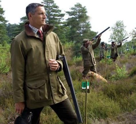
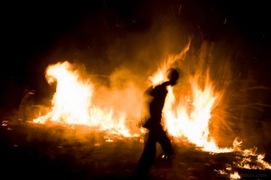

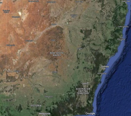
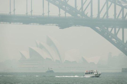

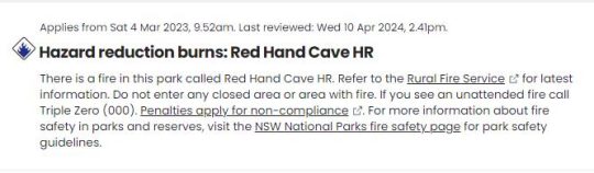

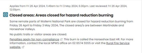
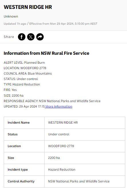


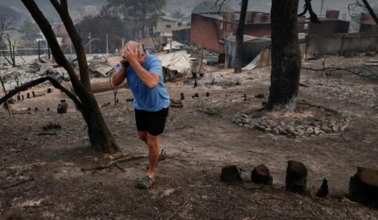


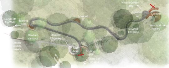

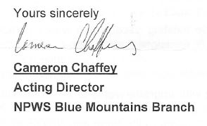

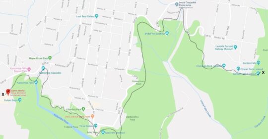
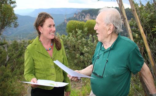
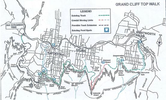

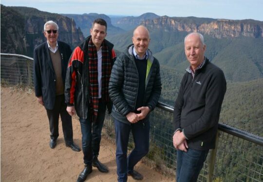
 Young Matt Kean – Gladys patsy to “Kick Start NSW Tourism” by the cruise ship load?
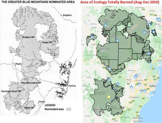
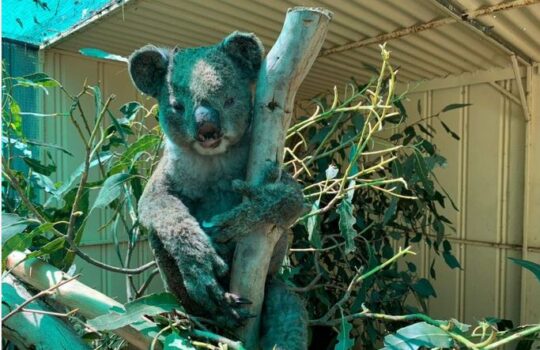
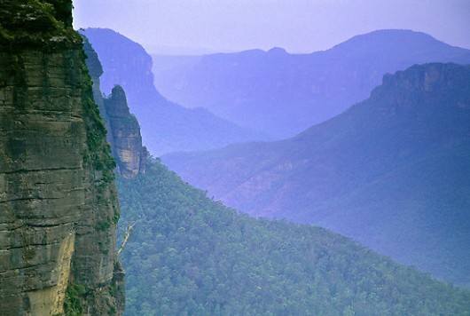
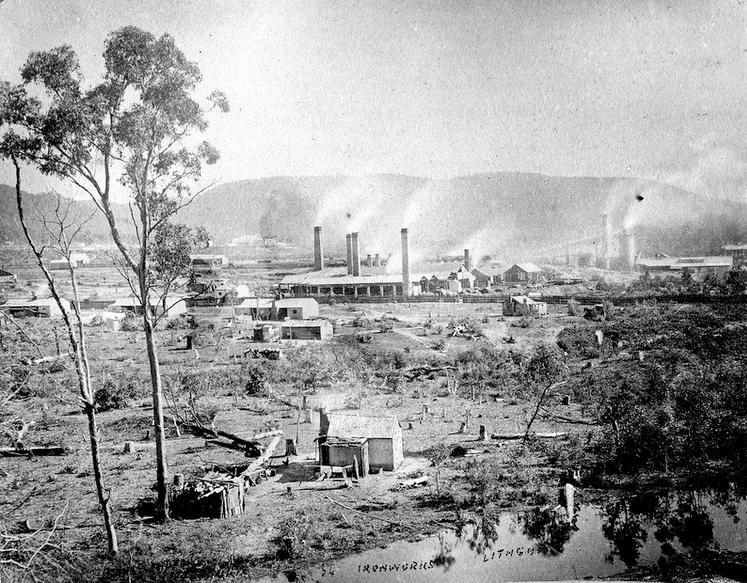
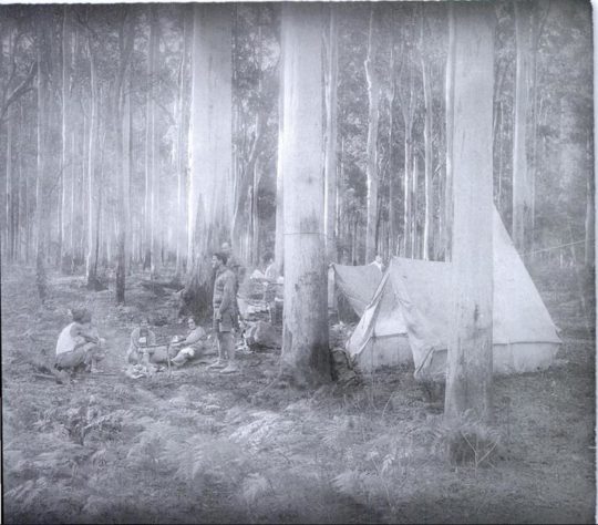

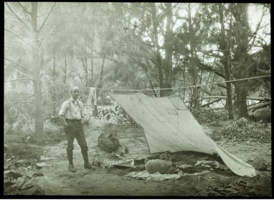

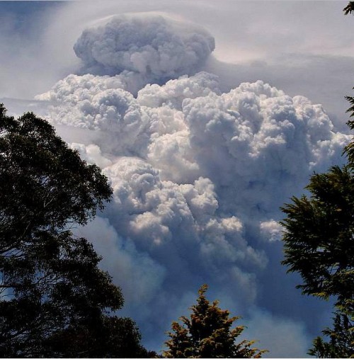
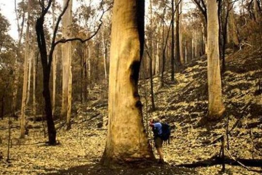
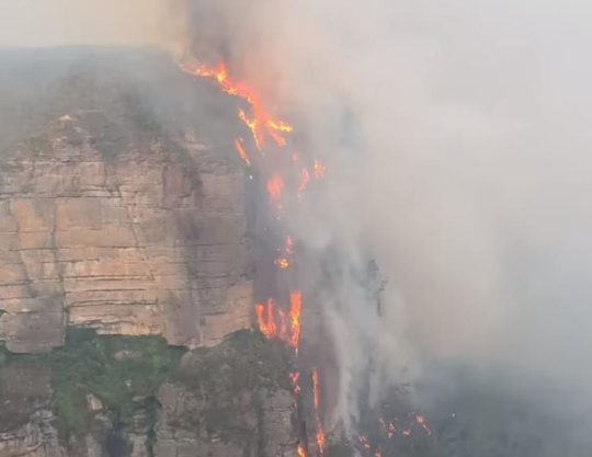
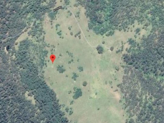
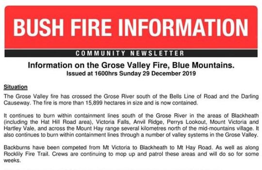

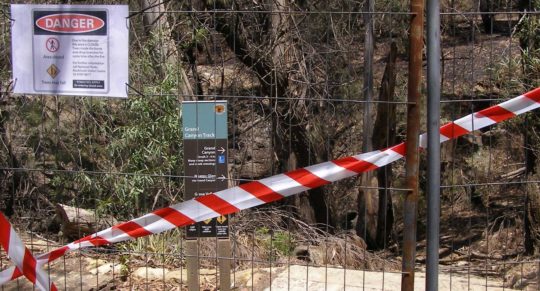
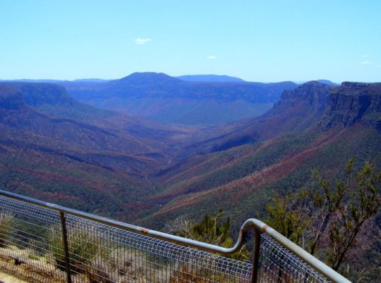

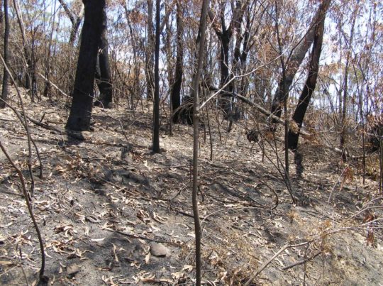

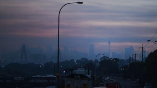
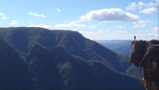
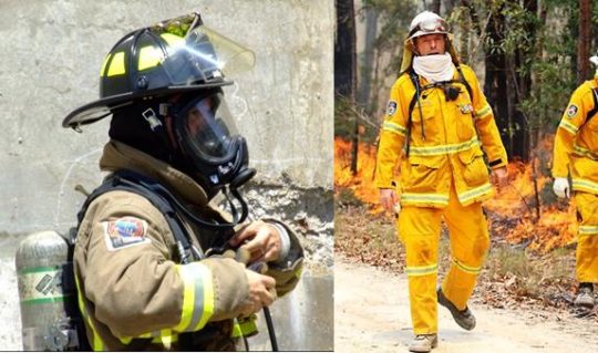
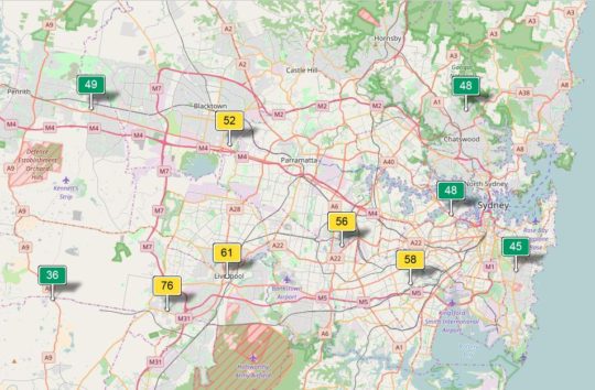
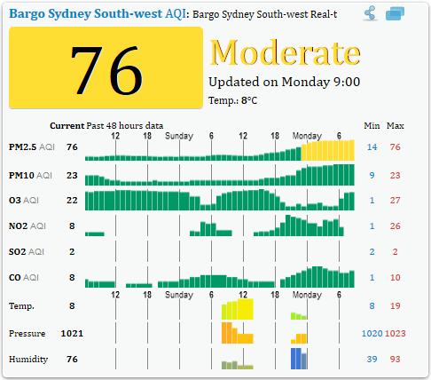
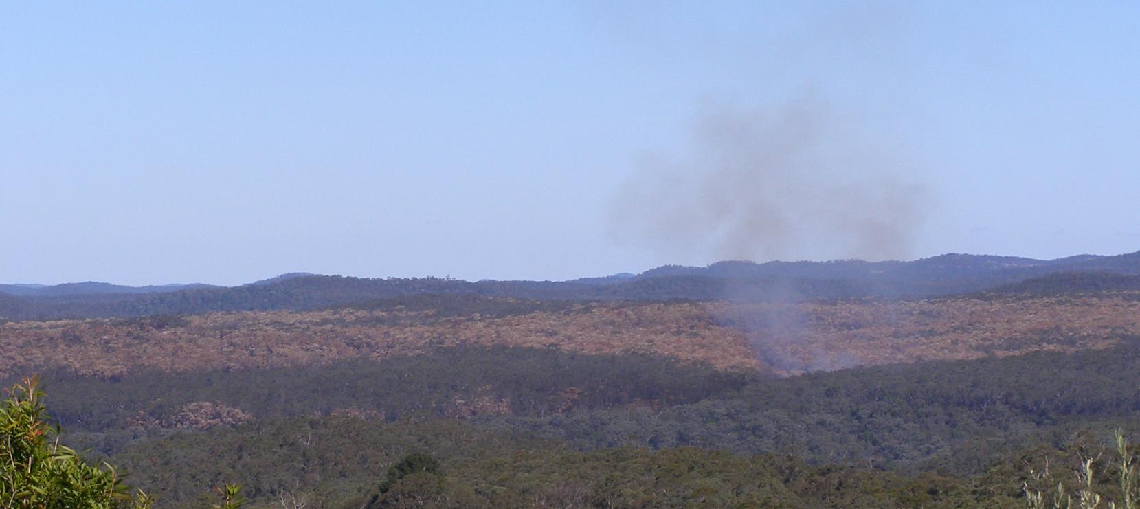


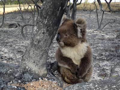
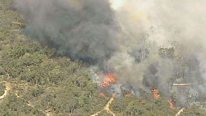
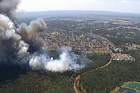
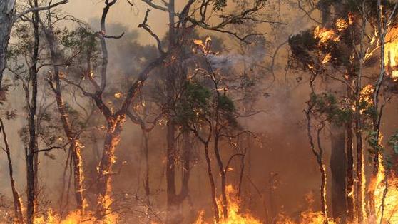


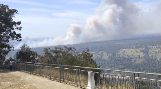
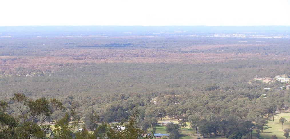
")


 The Tigerquoll (Dasyurus maculatus)
A rare and threatened top order predator of the Blue Mountains
The Tigerquoll (Dasyurus maculatus)
A rare and threatened top order predator of the Blue Mountains