Sometime back in early 2022, Blue Mountains {city} Council, in its insular ‘ivory tower’ bureaucratic wisdom, reckoned that wasting thousands of grant funding from the NSW Government on a so-called sandstone ‘yarning circle‘ for The Gully in Katoomba would be a public relations hoot!
Council’s yarning circle site was strategically chosen for maximum PR exposure for visitors to The Gully, just by the lake off Madge Walford Fountain carpark, just off Gates Avenue in Katoomba. Sure enough, the project, completed in February 2022, found its way to a press release in the local newspaper, the Blue Mountains Gazette, on 20th April 2022 entitled ‘Transforming The Gully’.
Council’s press release in the local Blue Mountains Gazette newspaper on page 12, dated 20th April 2022.
This press release states that this new stone yarning circle on..
“the edge of Catalina Lake in The Gully is slowly being transformed after the decade-long work of a vibrant bushcare group, Blue Mountains council’s environment team, the Gully Traditional Ownersand a special NSW environmental trust grant…. ayarning circle at the Gully and a YouTube bird watching tour are now just some of the welcome additions to the restorative Bushcare and Swampcare work.”
A stone yarning circle being part of restorative bushcare? Seriously?
Council previously had approved three similar stone circles nearby in The Gully back in 2008. That’s where an external grant of some $600,000 went – on an Aboriginal-only interpretative history path.
Sure, the dedicated group of volunteers of Garguree Swampcare Group who frequently convene in The Gully to weed out invasive plant species and plant out locally native plants do certainly effect restorative bushcare. The group formed a decade ago back in 2011 under the New South Wales Government’s Landcare NSW umbrella (not Council’s). As a local, the regenerative on-ground results of this volunteer group’s Swampcare efforts are readily observed by one walking around The Gully, especially noted inside the Dunlop Corner section of the old racetrack with the removal of all the blackberry and cotoneaster and the landscaping and planting out our of locally native plants and trees.
Former members of ‘The Friends’ would be well pleased that the native habitat restoration in this creek valley has continued since 2011. Yet sadly, no mention is made of the 27+ years of the Friends of Katoomba Falls Creek Valley Bushcare Group [1989 – 2016] and their related subgroups who continue to work in adjacent McRae’s Paddock and Selby Reserve, contributing many thousands of volunteer hours weeding The Gully of invasive plant species. Let the truth be told.
The Habitat Advocate has been based in The Gully Water Catchment since 2001 and over the two decades we have become very familiar with this rather special creek valley. Our editor walks around it weekly for exercise and peace of mind in Nature, not just the old racetrack, but south from the aquatic centre through MacRaes Paddock, Selby Reserve and to Katoomba Falls. He observes the goings on – the creek health, the landslips, continuing off-leash dog walkers, and the incremental new housing replacing the bushland along Wellington Street, etc.
Council’s press release states that the group’s volunteer co-ordinator David King (being a son of a former Gully resident) has been..“slowly mulching, planting, moving logs and stones to create habitat for the amazing number of aquatic birds that frequent the Lake – 100 have been recorded..The group is working hard to restore the delicate environment at the headwaters of the Katoomba Falls Creek and make it a happy place for new memories.”
The Habitat Advocate supports David King’s Swampcare leadership, wholeheartedly.
Council’s press release goes on…
‘Mr King said for thousands of years Garguree – which means The Gully – was a campsite that sustained the Gundungurra and Darug people. Indigenous communities were displaced when council approved a car racing track – the Catalina circuit – in 1957. It has been recognised as an Aboriginal place since 2002.
The 81 hectare site* is being cared for with the help of a Protecting our Places NSW Environmental Trust grant…Mr King said the lake habitat is linking with the riparian corridor works along Gedumba (sic) Creek and all the restoration works in the middle swamps and McRaes Paddock. The whole 81 hectares of The Gully is an incredible diverse wildlife haven and safe corridor linking up to the valley. While working around the lake it was decided that it would be a beautiful spot to also create a yarning circle on the lake for the Gully Traditional Owners and community to meet and share stories and cuppas.”
Garguree Swampcare has previously won the prestigious regional Indigenous Land Management Landcare Award in 2017.’
[* Editor: “81-hectare site?”
The Gully Water Catchment covers 290 hectares/2.9 km2 Dr Fred Ball’s 1993 Plan. So, Mr King’s 81 hectares represents a tiny 28% remnant of the creek valley’s water catchment area. However in fact, Blue Mountains {city} Council’s 2021 Plan at page 17 states the land area is 73.1 hectares as per the extract below, not 81 hectares; that is, unless Council’s doing another sneaky ursurp of its zoned community lands?…]
SOURCE: ‘The Gully Aboriginal Place of Management’, 2021-10-04, Section 1.1 Plan Area, page 17, by Blue Mountains {city} Council, with input by The Gully Traditional Owners, and funded by the NSW Government.
Again, The Habitat Advocate supports this habitat restoration endeavours wholeheartedly. But the timing of Council’s yarning circle is apposite. It took place during the period between July 2018 and October 2021 when Council was undertaking a revision of its 2004 Plan of Management for The Gully Aboriginal Place. Yet in both Council’s 2004 plan and subsequent 2021 plan, ‘yarning circles’ were not suggested, discussed, featured, nor budgeted for.
Instead, Council’s latest ‘yarning circle’ in The Gully seems to be some unplanned whim from grant funding undisclosed and outside any of the now 19 plans for and reports on The Gully. Maybe it was some bureaucrat’s whim within council with connections to the Parks Service to utilise excess stone blocks over-ordered for heli-upgrading of nearby hiking tracks in the national park. Voilà, another Council stone yarning circle crops up!
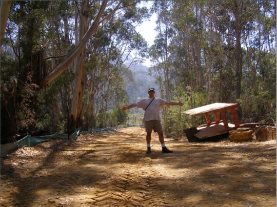
Anyway, so today we checked out this Council’s yarning circle down by the old artificial dam; a ten minute walk each way and took a few photos of it. Currently in the depth of winter, sitting on these fifteen cold hard sandstone blocks for too long would likely bring on a bout of haemorrhoids, so wise to bring a rug or two. The following photo was taken from the steps leading down to the lake, which originally provided the main access for swimming in the 1940s and 1950s before Council built its aquatic centre. Note the old changing sheds in the background.
Council’s transforming urbane vision in February 2022: It’s priority ‘yarning circle’ due to be just as another unused white elephant like Council’s $6 million concrete amphitheatre installed at Echo Point in 2019, save for PR media releases. [Photo by Editor, 2022-08-03]
Now this new ‘yarning circle’ is situated right by existing picnic tables on the lawn area behind next to the old racetrack and these serve to provide quite adequate seating for picnicking and if you like, some yarning. So it is an extraneous folly indeed.
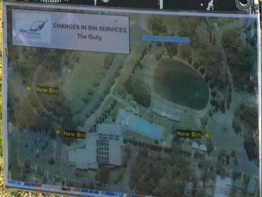
For some reason Council in its wisdom, also recently decided to remove the only rubbish bin on this side of the lake.
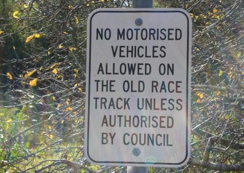
Council’s notice on the old racetrack near the lake
This is possibly because there is no Council ranger assigned to empty it. Instead there is a bin at the Madge Walford Fountain carpark side of the lake, and two of Council’s aquatic centre car park, meaning Council’s ranger now doesn’t have to walk far from his/her car to empty them – must be to do with OH&S walking.
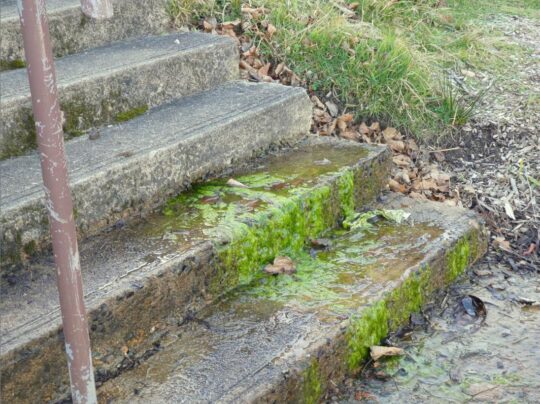
Speaking of safety, the site of this yarning circle is just metres down slope from a small freshwater spring that causes the grass in the vicinity to be constantly boggy. The site was originally a sedge swamp within the original natural riparian zone of the central creek; that is, before the artificial lake was constructed. The problem is that constant ground water seepage drains around and down the only steps leading to this new yarning circle below.
Concrete steps down to Council’s new stone yarning circle #4: Perennial spring ground water here causes moss to grow on the only downward step approach to the yarning circle, so creating a public trip hazard. Council is known to manage occasional grant funding for PR purposes, but has form in neglecting regular maintenance. May be the contractor for the yarning circle on the day responsibly swept away the moss; alas only to return. Council has no interest in The Gully besides its mandatory legal compliance, timely PR on occasion for the local rag and its glossy brochures despatched to ratepayers with their rate notices.
This is simply local knowledge by those like The Habitat Advocate who know this creek valley intimately. But Council in its ivory tower mindset constantly chooses not to consult with locals knowledge about its actions in The Gully. Yes, Council must first legally consult with The Gully Traditional Owners (GTO) as custodians of The Gully Aboriginal Place, yet despite none living within ‘Cooee!‘ of The Gully.
But the GTO would not have designed this folly and not at this location. When the interpretative walking pathway was designed, a primary feature was to enable disabled access so the pathway and boardwalks were all pre-designed to facilitate wheelchair access throughout.
The Gully’s interpretative pathway is wheelchair friendly so that it is accessible to anyone with a physical disability and mindful of the former residents (pre-1959) who are elderly to access this pathway – such a thoughtful design gesture. But the funding did not come from Council’s Environmental Levy as the now deteriorated sign to the right claims. It cam from a NSW Government Grant of $600,000 in 2008.
Key problem with this Interpretation Pathway biasely tell an Aboriginal-only story, not the true account about dispossessed poor folk who were Black and White and mixed. Council funded any of it, rather all the funding was external – NSW Government and Rous Water in the Northern Rivers region. Council did not seek or obtain a development application. Council did not seek or obtain any local community consultation, but only from the Gully Traditional Owners who were by 2008 usurping control in all decision making of The Gully to the deliberate exclusion of all other locals. Council deliberately and hatefully ostracised The Friends of Katoomba Falls Creel Valley Inc., who had undertaken considerable bushcare rehabilitation and lobbied Council since 1989 to protect this creek.
Council did not seek or obtain a development application. Council received no official clearance. It just thought it up and did it.
Sound familiar?
Apocalypse Now quote:
“Kurtz staged Operation Archangel with combined local forces, rated a major success.
He received no official clearance. He just thought it up and did it.
What balls.
They were gonna nail his ass to the floorboards for that one.
But after the press got a hold of it, they promoted him to full colonel instead.
Oh, man, the bullshit piled up so fast in Vietnam, you needed wings to stay above it.”
Former residents of The Gully (pre 1957-59) are elderly and many are observed by this author as being physically disabled, having attended a number of invited gatherings with former residents in The Gully. This points to this ‘yarning circle’ down by the lake, accessible by only by the steps, as being is a Council thing and likely contrived by some person without knowledge in perhaps Council’s PR department or by another one of Council’s external consultants driven in from distant Sydney.
Since at least 1981, a whole series of plans and reports to local Blue Mountains {city} Council on this creek valley have prescribed many environmental rehabilitation actions to be undertaken throughout. However precious little has been done by council as the custodial land manager. For instance, the ‘Bell Report’ of 1993 (plan #8) to Council on this creek valley in its executive summary on pages 6 and 7 identifies some sixty recommended actions for this creek valley of varying priorities as part of a prescribed environmental management plan. [Read More]. Had Council acted upon these recommendations then the Gully would have been truly transformed back to approximating its original ecological landscape and health as it was before the colonising usurpation since perhaps the mid-1800s.
Neither the Bell Report nor any of the 19 plans/reports (at least) on this creek valley include any ‘yarning circle’ nor ‘stone circle’, nor even a ‘crop circle’.
Council holds a condescending penchant for installing ‘yarning circle ‘follies for Aboriginal use, with now three in The Gully and one at Echo Point. So where’s this nutty motivation coming from?
Blue Mountains {city} Council has already approved three other such stone block gathering places or ‘yarning circles’ in The Gully. These were part of its approval in 2008 for an Aboriginal interpretative meandering pathway concreted inside its terminated Catalina Park motor racing circuit. It serves to showcase the history of prior Aboriginal residents of The Gully – which Council forcibly evicted between 1957 and 1959 for its motor racing mates.
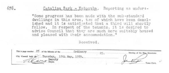
Evidential of the truth, Council’s meeting minutes recorded this back in 1959:
Truth telling
So why the need for a fourth stone circle in The Gully? And why position it adjacent to an invasive dam that was built by non-Aboriginal people over the top of the pre-existing riparian zone of the creek?
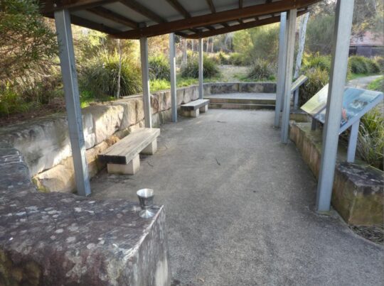
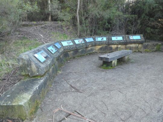
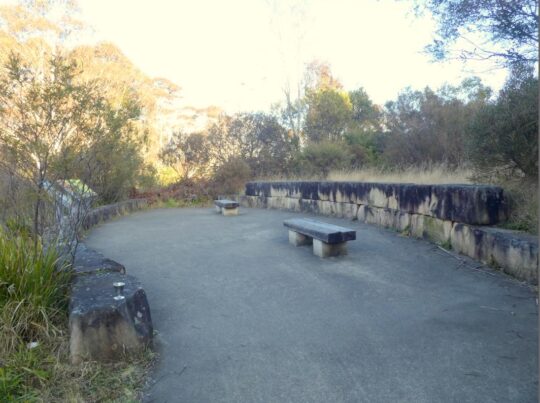
Here we show Council’s other three ‘stone circles’ in The Gully.
Stone Yarning Circle #1 – Notice how blackened the sandstone has become over time to moisture attracting mould in the wet pervious sandstone after 14 years and the lack of Council maintenance. Not exactly an aesthetically welcome look now
Stone Yarning Circle #2. Actually this is the site where in 2001 Council provided dump truck access so the RTA could dump hundreds of tonnes of sand and rock fill on top of The Gully sedge swamp from its highway cutting at the Soldiers Pinch bypass excavation project near Mount Victoria. More black mould neglected by Council.
Stone Yarning Circle #3. More black mould neglected by Council. We predict Council’s latest fourth yarning circle will similarly deteriorate in a few years time due to its record of ignoring maintenance.
The invasive non-Aboriginal history of this creek valley
Council’s stone ‘yarning circle’ is artificial just like the artificial lake adjacent. It is pure aesthetics and seems to be a public relations ploy by Council to showcase: “Look, Council is actually doing something constructive in The Gully!”
But Council’s latest haemorrhoid yarning circle achieves precious little in rehabilitating the riparian zone habitat of this decades-long neglected and abused creek valley.
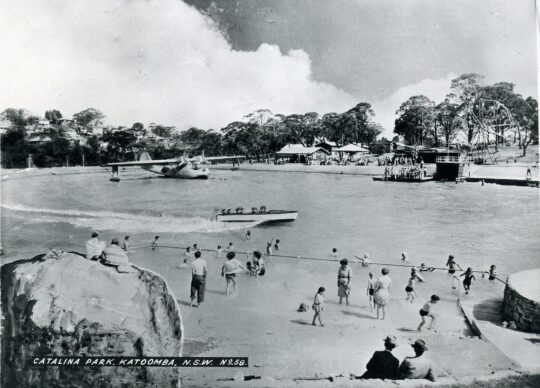
For starters, the lake adjacent is actually a dam that was constructed post-WWII over the top of the old ‘Frogs Hollow’ spring/swamp riparian area of Katoomba Falls Creek by local tourist entrepreneur at the time, one Horace Gates. It was part of his grand scheme to impose a carnival amusement park called ‘Catalina Park’ in the valley.. offering ‘every facility for fun and food’.
Horrie in 1948 seconded the shell of an old Catalina PBY-5 flying boat for his new dam as a unique tourist attraction to his amusement park. By 1949 he arranged for local council to supply 100,000 gallons of water for it, metered at 1/6d. per thousand litres. [Council of the Blue Mountains meeting minute :’Supply of Water to H. Gates for Catalina Park’, dated 11th January 1949, 7 pm, page 3.]
Horrie also paid £500 towards the £2,500 cost of constructing new Plantation Street westward between Cascade Street and his Catalina Park that same year. [Council of the Blue Mountains meeting minute :’Plantation Street: Katoomba’, dated 15th February 1949, 7:30 pm, page 183.]
Horries’ new ‘Catalina Park’ subsequently served to provide various attractions and activitioes including speedboat rides, tearooms, miniature train, a Ferris wheel, merry-go-round, swimming pool and a Giggle House showing Charlie Chaplin films.
Horace Gates’ Catalina Park circa 1950. This was during summer of course, since the water temperature can get down to 4o degrees celsius in winter months. The concrete steps to the now stone ‘yarning circle’ would be off picture to the right.
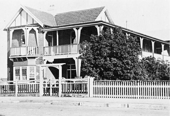
Horrie also locally owned an amusement parlour on the north-west corner of Katoomba and Waratah Streets, as well as his ‘Homesdale Guesthouse‘ at 207 Katoomba Street including its Wentworth Cabaret nightspot downstairs. Subsequently the guesthouse was replaced to become the much larger Katoomba Corps branch of the Salvation Army, then in 2021 it was converted into backpacker accommodation of international Youth Hostels Association (YHA).
Homesdale Guesthouse in the 1920s. Horrie wasn’t exactly short of a few bob and had influence on Council to acquire the portion of The Gully he named Catalina Park in the post-war 1940s.
Katoomba tourism was Horrie’s thing 1920s into the 1950s. He was a relatively successful entrepreneurial businessman of Katoomba. But he used his wealth to be one of the many usurpers of The Gully.
But Horrie cared not for the welfare or quite enjoyment of the adjacent residents of The Gully. They were mostly Aboriginal impoverished families subsisting in meagre self-made shacks in the bush with no utilities – having no running water, no electricity, no gas, may be septic tanks pre-1907. Thereafter Council imposed town sewage be trenched throughout the creek valley, yet not connected to any of the Gully shacks (councillors didn’t want to encourage what they regarded as a shanty bush settlement on the edge of town).
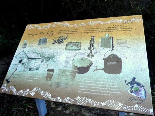
A walking visit to The Gully these days reveals interpretative signage record of the simple subsistence living conditions that former residents endured before Council’s forced evictions and calling in the bulldozers 1957-1959.
Living in The Gully was basic bush camping
May be there was one toilet block for the entire Gully if they were lucky. May be that tiny brick one below Wells Street, or was it a more recent addition for overnighting campers attending motor race meets later in the 1960s and 1970s?
By the early-1950s, Catalina Park as then an amusement park was pretty dated and run down. When Horrie died, Council named Plantation Street adjacent as ‘Gates Avenue’ and Horrie’s dam as ‘Catalina Lake’. Council in the 2000’s renamed a nearby short portion of Farnells Road as ‘Catalina Avenue’ as an appeasement gesture to the petrol-head fraternity bemoaning Council’s 2002 closure of their Catalina Park motor racing circuit just by the lake.
This use of The Gully was all entirely non-Aboriginal use and exploitation by wealthy outsiders – the amusement park (1946-1950s) followed by the raceway (1957-2001). So the pertinent question in relation to this fourth stone yarning circle by Council is why spend money complementing an unnatural part of The Gully. This is just another whim, indeed a folly.
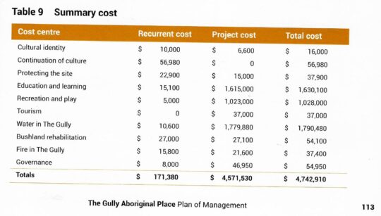
Who’s idea was it? How much did it cost? Why did this civil works project take priority over many other priority ecological rehabilitation actions in the valley as prescribed by many plans of management since at least 1981? Surely, given the latest Plan of Management of October 2021, the use of that “special NSW environmental trust grant” as quoted in the newspaper article, should have applied to the action items listed in that plan. The 2021 plan lists a mere 6 action items on page 111. , just 10% of the 1993 plan.
In comparison to the 1993 plan of management’s 60 recommended action items, Council’s 2021 plan list a mere 6 ‘governance actions’ on page 111 budgeted to cost $54,950. How much did this fourth stone yarning circle project cost? On page 113 indicates a massive budget of $4,742,910 to implement the latest plan of management. But this list is not about habitat restoration of The Gully, its all about human usage as the following cost summary reveals:
Truth telling: The Gully Aboriginal Place 2021 Plan of Management
Council’s 2021 plan includes a pie-in-the-sky budget totalling a massive $4,742,910. Co-incidentally Council’s 2004 plan budgeted a similar $4,682,000. Didn’t happen.
Council’s 1996 (Connell Wagner) Plan listed many distinct habitat restoration focuses and action plans for each portion of the creek valley, then respectively named Frank Walford Park, McRaes Paddock, Katoomba Park, and included Katoomba Golf Course. Featured in all four portions included regenerating of re-vegetation degraded areas and rehabilitating swamps and bushland. Budgeted total costs came in at $794,500.
Didn’t happen.
Council’s 2021 plan won’t happen. This latest plan is set to be mothballed by Council again, because like the 18 previous reports and plans on this riparian valley, the 2021 plan contains the usual escape clause to allow Council to do again nothing in The Gully. A funding excuse. Council is legally compelled by the New South Wales Government to prepare a plan of management for a public (community) land it controls/owns such as The Gully, but Council in its history is yet to seek the requisite budgeted external funding for any plan for The Gully in order to complete the recommended action items.
May we suggest to the insular thought bubble that is Blue Mountains {city} Council that rather than it have imposed a 4th Celtic yarning circle in The Gully for the rarely seen Aboriginal folk around, that Council instead focus its cash on more pressing public safety measures in and around The Gully?
Below is one such pressing public safety problem deserving Council’s prompt maintenance.
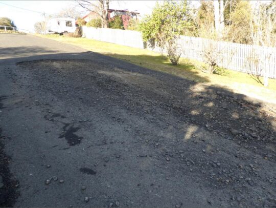
It’s possibly the largest pothole currently besetting the Blue Mountains at some 4×2 metres in size!
It’s situated down the very steep road of Warriga Street on the eastern approach to The Gully. Such being the months of this pothole’s deterioration, one almost needs 4×4 vehicle to currently negotiate through it!
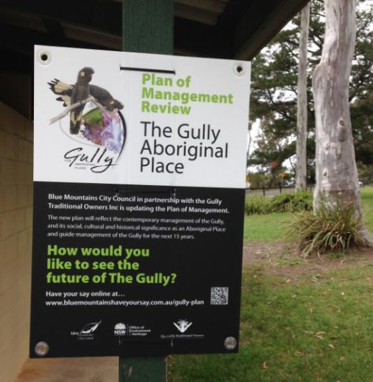
While exercising through Katoomba Falls Creek Valley in the Blue Mountains last October, this author came across this sign.
How would one like to see the future of The Gully..for the next 15 years? Have my say? Internet submissions only?
Local government authority Blue Mountains Council in about 2007 renamed this natural valley west of Katoomba ‘The Gully’ because that is the affectionate name it had from the previous residents of mostly regional Aboriginal heritage extending back many thousands of years.
Since 2001, this author has lived 50 metres from the native bushland valley we know as Katoomba Falls Creek Valley, or Sydney Water’s defined Upper Kedumba River, or as Amusement Parlour tourism businessman Horrace Gates’ Catalina Lake, or as Blue Mountains Council’s sponsored car racing enthusiasts (1957-2003) as Catalina Park, or as NSW National Parks call the valley, ‘The Gully’.
Such mixed interpretation of this watercouse valley reflects its history as complex, contested and ongoing culturally problematic. Yet since 1957, here we are in cultural denial in 2019.
In 2002, The Valley was unilaterally declared ‘The Gully’ by Blue Mountains Council – typically again no community consultation.
Ok, so what’s in a name?
‘The Gully – Aboriginal Place’ under the National Parks and Wildlife Act 1974 by the New South Wales government was justified out of recognition of the Valley’s significance holding pre-contact Aboriginal sites, post-contact settlements, its ongoing occupation by Aboriginal People until forced eviction in 1957 (to make way for bulldozing a racetrack), and by lobbying and evidence from local Aboriginal Gundungurra elder, the late Aunty Dawn Colless.
All good. But ‘Aboriginal Place’ only? Says who? By which Blue Mountains heritage Aboriginal people/clan? The Gundungurra Traditional Owners Inc. only and so denying the rights of all other Gully residents and descendants – Aboriginal (eg: Dharug or otherwise) or of non-Aborigines of The Gully?
This is at best Council prejudice and community divide and conquer; at worst Council prejudice against non-Gundungurra, non-Aborigines.
Aboriginal Place declaration while historially valid, was democratically invalid. The NSW Government declaration of such was selective and secret behind Blue Mountains Council’s closed doors – a frequent setting to get things done without pesky outspoken community awareness.
Trust? Blue Mountains Council?
From 1988 to 2016 local residents action group The Friends of Katoomba Falls Creek Valley Inc., under the inspiring and consultative leadership of the late Neil Stuart BSc., had championed a local community cause to save the Valley. From grassroots local resident motives, the Friends aims were from the outset consistently to value and respect the remnant environmental values of the Valley, to lobby to remove the invasive racetrack, to restore the Valley’s ecological integrity throughout and to foster a local community management structure to underpin the Valley’s environmental protection and rehabilition.
Basically The Friends set in train a local community management structure to care for country – the Valley as we called it. But Blue Mountains Council hegemony, situated less than 200 metres east of the Valley, corporate-culturally frustrated and ostracised The Friends out of having any say, participantion or rights in caring for the Valley.
As the awareness of the tragic local Aboriginal past was realised, The Friends respected, engaged and partnered with former residents of The Gully and their descendants (irrespective of racial background). The goal was to properly protect, rehabilitate and manage this acknowledged special place collaboratively. It was a noble mission and undertaking. The activism occupied core Friends members half an adult lifetime, proudly.
Yours truly joined The Friends’ fight to save the valley for just five years from 2002 to 2007 until other commitments took family priority.
The nearly three decades of local resident activism well exceeds the capacity of this article. Suffice to say that the resultant ‘Upper Kedumba River Valley Plans of Management Revised 2004’ achieved not just a desired and just termination to the car racing invasion, but signalled an opportunity and hope for local community partnering with Blue Mountains Council and NSW Parks Service to manage and restore the valley as a valued natural place.
So there is this new signage put up by Blue Mountains Council. After fourteen years, Blue Mountains Council deems The Gully Plan of Management is up for renewal, whatever that means.
Blue Mountains Council claims “This Plan of Management (POM) is fourteen years old and does not reflect the contemporary cultural values and perspectives held by the Gully community.” But what are these?
The local Katoomba community in and around The Gully continues to be shut out of secret talks with the parks service and only select Aborigines – The Gundungurra Traditional Owners Inc. – the legal custodians of most of the valley as appointed by closed shop local council with absolute control over the valley since 2007.
Council entered into an exclusive co-management agreement with The Gully’s traditional owners in 2008, recognising the owners’ deep connection to the place. What about the Dharug? What about other community members who share a deep conservation interest in preserving and rehabilitating the Valley’s ecological values?
Council claims: “Funding from the Office of Environment and Heritage, NSW Heritage Grants – Aboriginal Heritage Projects has been made available to review and up the Plan of Management for the Gully.” But what are these?
“Engagement and consultation with former Gully residents, their descendants and other stakeholders”. Who’s a stakeholder? Blue Mountains Council? The NSW Parks Service? This is not made clear. What about the local community, former members of The Friends of Katoomba Falls Creek Valley Inc. who volunteered years of their lives to save and protect the Gully/Valley from all sorts of harm and development threats?
Council instructs: “The Plan of Management review is being undertaken by Blue Mountains City Council in cooperation with the Gully Traditional Owners Inc.”
Why exclusively this one group of limited Aboriginal representation? Convenience? Simplicity? Becuase the planned outcome has already been decided? What about council consulting with Aboriginal Dharug residents actually born in the Valley/Gully? What about consulting with the immediate local community irrespective of racial background?
Council’s initiated review was made public from about October 2018.
Spell check?
Council instructs that in preparing its revised Plan of Management, its process will include:
Engagement and consultation with former Gully residents, their descendants and other stakeholders
Assessment of relevant information and knowledge to be included in the revised plan
Assessment and determination of current management issues and future opportunities for the Gully
Updating of the management policies and the action plan for the Gully
Prioritisation and costing of actions and works
Except that the entire process is secret. Is it to play into the hands of a few powerful and influential people? Does local council have something to hide from the local community and non-Gundungurra former residents and their decendants until commercial contracts in confidence are signed and its too late to object?
Council instructs: “The existing Plan of Management does not include the Katoomba Falls sports fields or the Tourist Park. The inclusion of these areas into the Gully plan of Management is a significant change from the existing plan.” What is the reason and motive for including more land into the proposed new plan of management?
Council instructs: “The revised Plan will be developed with reference to the Local Government Act 1993, the Crown Lands Management Act 2016, the National Parks and Wildlife Act 1974, and with the Guideline for Developing Management Plans for declared Aboriginal Places. (OEH 2012) The plan also needs to consider the future implications of the Aboriginal Cultural Heritage Bill 2018, which is earmarked to replace functions of the National Parks and Wildlife Act 1974 in relation to the management and protection of Aboriginal places.”
Council acknowledges: ‘The Gully’ was a place where Gundungurra, Darug and other Aboriginal and non-Aboriginal people lived as a fringe community from around the 1890’s onward over a number of generations.”
Council’s References Used:
Local Government Act 1993 (NSW)
Crown Lands Management Act 2016 (NSW)
National Parks and Wildlife Act 1974 (NSW)
Aboriginal Cultural Heritage Bill 2018 (NSW) – earmarked to replace functions of the National Parks and Wildlife Act 1974 in relation to the management and protection of Aboriginal places.
Guidelines for Developing Management Plans for declared Aboriginal Places, NSW Office of Environment and Heritage (2012)
Council has restricted consultative capture of any local community input to some outsourced website based software outfit in Melbourne: Bang The Table’s ‘Have Your Say’: https://www.bluemountainshaveyoursay.com.au/gully-plan Yet Blue Mountains Council’s website now instructs: “Consultation has concluded”.
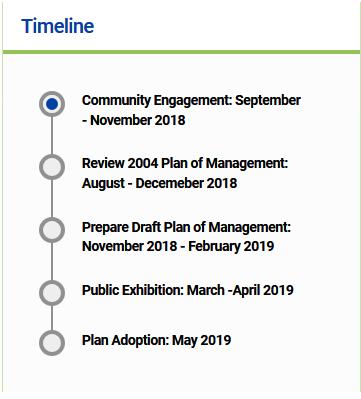
It’s July 2019 and Blue Mountains Council’s webpage on this process shows the following timeline update:
It would suggest that insufficient resources have been allocated or there are delays in the communications process,or insufficient scheduled time was provided for this project from the outset, or a combination of these.
If local stakeholders missed out on finding out what is going on, should they just await Blue Mountains Council’s press release on its pre-decision making?
Chairperson of the Gully Traditional Owner Inc., Aunty Merle Williams, says: “The Gully is a sacred place to the Aboriginal community who came from the Gully. It was a place for everybody, regardless of who you were or where you came from. It is important that The Gully is managed in a culturally appropriate way using both traditional and contemporary practices.”
The mayor, Mark Greenhill, said council had a strong commitment to working closely with traditional owner groups to care for country. “The revised plan of management for The Gully will guide the future use and management of this significant site over the next 10-15 years.”
Ok so regardless of who you were or where you came from, why are non-members of the Gundungurra Traditional Owners Inc. being excluded from consultation in Blue Mountains Council’s review process?
A brief insight into ‘The Friends of Katoomba Falls Creek Valley Inc.’ and their efforts to protect a special place.
“Gain a short, little known insight into a small group of thoughtful, committed citizens who came together led by the late Neil Stuart to become guardians of a very special natural valley in the Upper Blue Mountains. Learn about the wealth of stories, how over 26 years locals cared for the valley’s integrity, how volunteers committed to half a lifetime of unpaid bushcare, made and sold jam at street stalls to raise funds, and fought a council Goliath. Be shocked by the truth of what really happened in 1957 and the lifetime trauma to what was once an harmonious yet socially marginalised community subsisting on Katoomba’s fringe.
This is of living contemporary social history. This is a controversial expose into one group’s community volunteerism, activism, environmentalism and nimbyism and social justice – thousands of hours given up to save ‘Katoomba Falls Creek Valley’, known by some as ‘The Gully’, known by others as ‘Catalina Raceway’.
This is very much an Australian story, a microcosm of Australian history and pre-history – one locally as rich as it is beautiful yet very sad. It has impacted upon dozens of locals, old families and their ancestors. It is a story about respecting the natural, anthropological and community values of one valley. Recent history became complex, protracted and nasty – involving displacement, forced eviction, invasion, desecration, secret deals, politics, animosities, divide-and-conquer manipulation, empty political promises, conflicting interests, threats and designs by influential millions, the various meetings, many plans of development (some silly), token consultation, one of metaphorically trying to herd cats and twenty six years of community emotional snakes and ladders.
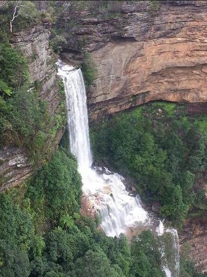
Katoomba Falls
This presentation was delivered by a former member of ‘The Friends’ yesterday at Hobby Reach, Wentworth Falls, the home of the Blue Mountains Historical Society Inc.
For those who attended and requested the reading of the poem…
<< I can feel the souls of my ancestors calling me back home
To all the familiar places and tracks I once did roam
I can see my Grandmother’s house at the end of Adams Street,
Where all the Aunties, Uncles and Cousins I did meet
To the banks of the Bokhara River running under the Richmond Bridge
You can hear the waters flow to the sound of an Elder’s didge
I can smell the boogalies cooking in a camp oven at my Aunty’s place
I can see the sun arising on the wrinkles of my Pop’s face
I can recall how my uncle taught me how to ride
In a paddock near their place with Robbo by my side
But I know I must stay here to get a good education
For I want to go back home after my graduation
To see the many family, friends and familiar faces I have known
I can feel the souls of my ancestors calling me back home
They’re calling me back, my ancestors in Mother Earth
I want to go back home, to the country of my birth. >>
Crimson Rosella in snow, a native to The Gully
(Platycercus elegans)
(Photo by Editor, 20121012, free in public domain, click image to enlarge)
.
It rarely snows in Katoomba in the Blue Mountains these days. In the old days it used to snow every winter, but these days we are lucky to get a brief flurry in August that doesn’t even settle.
So this morning was exceptional. The forecast today (Friday) was for a storm further south, but at 6am in Katoomba it started snowing. And in the middle of October (spring)!
Then it kept snowing and kept snowing ‘ till after 1pm. A few big tree branches crashed under the weight of snow. The streets and roads steadily became blanketed in snow, making them slippery and dangerous to most vehicles. The Great Western Highway remains closed. The trains are snowbound up at Mount Vic. It’s like we’re in the Alps where snow there is normal, but here no-one was ready for it. Snow has regrettably become a freak event in the Blue Mountains.
We must have received about half a foot of snow by lunchtime. Everything became soft white in a black and white landscape.
So it became quite a special morning and well worth a walk around The Gully in the snow.
.
The Gully in Snow
(Photo by Editor, 20121012, free in public domain, click image to enlarge)
.
(Click play, then click full screen icon at bottom right of video)
.
Streets around The Gully in Snow
(Photo by Editor, 20121012, free in public domain, click image to enlarge)
.
Tyre tracks through the snow in Katoomba
(Photo by Editor, 20121012, free in public domain, click image to enlarge)
Illegal dumping in The Gully, Katoomba, Blue Mountains
Reported to local council and promptly removed by local council.
(Photo by Editor 20060702, image free in public domain, click to enlarge)
.
Illegal dumping is not unique to the Blue Mountains, but it continues to be an ongoing problem in this populated area that is situated upstream of the internationally valued Blue Mountains World Heritage Area.
Whereas litter is generally individual items of waste products improperly disposed of in the environment, illegal dumping is generally of a larger scale and premeditated. Both are illegal.
Both are selfish, lazy and disrespectful to society and the environment. The larger problem of illegal dumping involves the deliberate or unauthorised dumping, tipping or burying of waste on land that is not licensed or fit to accept that waste. People illegally dump bags of household rubbish, electronic equipment, furniture, mattresses, industrial wastes, construction and demolition materials, garden waste, packaging, tyres, old cars and soil.
It is bad enough that an increasingly populating society that is also increasingly consuming resources is also increasingly contributing to landfill for its waste. Worse is when that waste is illegally dumped and far worse when it is dumped in places that harm native ecology.
Lawn Clippings dumped at remote Hargreaves Lookout Road, west of Blackheath in protected bushland, Blue Mountains, New South Wales
(Photo by Editor 20080405, image free in public domain, click to enlarge)
.
Illegal dumping is more than just unsightly waste in an inappropriate location. It not only reduces property values and costs rate payers a substantial amount of money each year to clean up. Illegal dumping is inherently unnatural which means when dumped in a natural environment, the composition of the waste will have an adverse impact upon the natural ecology – it degrades and spoils local ecology. The waste does not have to be deemed ‘hazardous’ such as toxic chemicals, paints, solvents, fertilizers, pesticides, herbicides or asbestos for instance.
Lawn clippings and woodchips will cause a moist environment for bacteria and flies to breed and after rain the nutrients will flow and contaminate surrounding soils, vegetation and watercourses. This can be lethal to vulnerable and fragile flora and fauna, especially in Australia which naturally has low nutrient soils.
Illegally dumped waste can poison the soil and kill vegetation. The introduced nutrients such as acids will prevent the vegetation from regenerating and dependent wildlife from returning. Illegal dumping leads to long-term contamination of land, waterways, natural springs and groundwater, particularly when the waste is from an industrial source or contaminated soil.
Subsoil and rubble (left) dumped in The Gully (Katoomba), alongside the old race track
(Photo by Editor 20070310, free in public domain, click to enlarge)
.
Illegal dumping can be dangerous to people (broken glass, syringes, nappies and medical waste, and carcinogenic substances like asbestos) but also it can attract rodents, insects and other vermin. It can provide an ideal breeding ground for mosquitoes and maggots. It can block waterways and stormwater drains, increasing the potential for flooding and erosion, and it can be a potential fire hazard.
The most common cause of illegal dumping in the Blue Mountains is typically on the side of a road where a motorist has carted the waste by trailer.
.
Perhaps it is time to outlaw trailers and to replace them with waste collection services only provided by local council.
.
After all, if there is no means available to cart waste except by hand, the volume of illegal dumping will be reduced and the ability of illegal dumping to be away from residential areas and in natural areas will also be reduced.
Of course trucks can cart larger quantities of waste, but fewer people have access to trucks. This does not mean that greater regulation cannot be imposed on truck drivers. Perhaps every truck load needs to be registered and inspected by local council authorities, or an effective penalty imposed – say $5000 or a custodial sentence.
.
Whatever an effective mix of solutions, unless governments are serious about addressing the problem, illegal dumping shall continue unabated.
.
Lenient law enforcement or the absence thereof, contribute to illegal dumping behaviour – and be clear, we are dealing with a human behavioural issue here.
In 2001, hundreds of tonnes of sand and rubble from the Soldiers Pinch upgrade to the Great Western Highway (Mount Victoria) was dumped by the RTA in The Gully over the top of an Upland Swamp. Permission was given by the Blue Mountains City Council, but without any community consultation. Subsequent actions by the Council involved planting on top of the compressed rubble, instead of properly removing it.
(Photo by Editor 20060702, 5 years on from the 2001 dumping little had grown.
Image free in public domain, click image to enlarge)
.
Shaping correct responsible behaviour requires a combination of a ‘carrot’ incentive and ‘stick’ deterrent approach. If waste is collected from households like weekly garbage, then the incentive for illegal dumping is reduced. Why go to the trouble of driving somewhere to dump when it can be collected from your residence? Similarly, if the cost of collection is low, the incentive to utilise the collection service is stronger.
As the cost of landfill fees is rising due to reducing number of suitable tip sites, some people in order to avoid disposal fees at landfills will choose to illegally dump to save money. the risk of getting caught is low and this is the core problem in trying to change this bad behaviour.
Over 20 tonnes of rubble dumped in The Gully by Sydney Water as part of its Sewerage Amplification Project in 2005
(Photo by Editor 20120624, free in public domain, click image to enlarge)
.
Penalties for illegal dumping vary around the country. For instance, in Queensland under its Waste Reduction and Recycling Act 2011, there are a range of offences for litter and illegal dumping from $200 on the spot fine for littering through to $16,500 for illegal dumping of large domestic items such as fridges, garden refuse and construction material.
But most offenders do not get caught because the scale of monitoring is unwieldy and practically ubiquitous.
In Victoria , a landfill levy on all households has helped to fund a dedicated Illegal Dumping Strike Force team as part of the Environment Protection Authority in that State. It’s tasks are to support businesses to understand their legal requirements for managing waste and recyclable material, work with its council partners and other government agencies to share intelligence about dumping offences and hotspots, and to investigate and enforce against incidents of large-scale industrial waste dumping.
Household garbage illegally dumped in The Gully near the South Katoomba Rural Fire Brigade, July 2012
(Photo by Editor, 20120703, free in public domain, click image to enlarge)
.
In the Hunter Valley of New South Wales, the Hunter and Central Coast Regional Environmental Management Strategy (HCCREMS) in its Illegal Dumping project is seeking to address illegal dumping in the region through a range of new initiatives.
Designing and trialing a number of enforcement campaigns to gain further data on illegal dumping ‘hot spots’ and determine effective campaign styles
Trialing different illegal dumping deterrence methods (barriers, cameras, gates, etc) to determine their effectiveness at stopping illegal dumping
Collating illegal dumping data, take photographs and coordinate media and community awareness activities.
Establishing an Illegal Dumping Regional Database using Microsoft Access database software to collate and analyse data collected by councils, from dumping sites. All incidents are entered into the database, which is linked to GIS and is able to produce maps of the locations in each council area.
Allowing Councils to use the intelligence generated from the database to determine appropriate and effective inspection patrol regimes and where access control measures can be installed.
Encouraging all councils to record incidents of illegal dumping on the incident forms developed by the Hunter Regional Illegal Dumping Group and forward these into HCCREMS for entry into the database.
Sample Record of Illegal Dumping reported to Blue Mountains Council by residents
.
Jan 2008: Dumped Garden Refuse opposite 16 Garden St, Katoomba
To The General Manager, BMCCEmailed to council@bmcc.nsw.gov.au
.
‘Sir,
I request for the removal of dumped garden refuse within a bushland adjacent Carlton Street, Katoomba, opposite 16 Garden Street (located at the corner of Garden St and Carlton St). The garden refuse contains weeds and is near a large rock.
Dumped building waste (opposite a recently built house at 20 Carlton St) and cut down trees are also present within the bushland.
Please see attached photographs.
Also, I recommend that Council arrange for its ranger to inform nearby local residents that it is illegal to dump garden refuse and building waste under the Protection of the Environment Operations Act and cut down trees under the Tree Preservation Order. Garden refuse smothers native vegetation, spreads weeds and increases bush fire danger.
As you will be aware, the cutting down of native trees for firewood reduces habitat and creates wood smoke pollution.’
.
Apr 2007: Opposite Megalong Lodge, 40 Acacia Street Katoomba
.
To The General Manager, BMCCEmailed to council@bmcc.nsw.gov.au
.
‘Sir,
I request Council removes a very large amount of dumped garden refuse within escarpment bushland, located adjacent Cliff Drive and across the road from Megalong Lodge, 40 Acacia St, Katoomba.
The dumped refuse is believed to have come from Megalong Lodge, as it is made up of white driveway pebbles, pine needles, Agapanthus and Rhododendron cuttings found on this property. A bush trail in direct line to the property also contains the cuttings. Grass clippings have also been dumped.
Urgent removal of the garden refuse is recommended, since exotic grass is beginning to grow within the escarpment bushland. The dumping was discovered in April 2007. Please see attached photographs.
Also request the ranger to inform nearby local residents that it is illegal to dump garden refuse under the Protection of the Environment Operations Act. Garden refuse is pollution and smothers native vegetation, spreads weeds and increases bush fire danger.‘
.
Dec 2007: Outside Katoomba Golf Club
To The General Manager, BMCCEmailed to council@bmcc.nsw.gov.au
.
‘Sir,
I request for the removal of dumped grass clippings within bushland at Katoomba Golf Course, opposite 165 Narrow Neck Road, Katoomba. Dumped clippings are located next to the golf course entrance turnstile. The front lawn of 161 Narrow Neck Road had just been mown at the time of discovery of the still green clippings.Please see the attached photograph.
Also, I request a Council ranger to inform nearby local residents that it is illegal to dump grass cuttings under the Protection of the Environment Operations Act. Grass cuttings smother native vegetation, spread weeds and increase bush fire danger.’
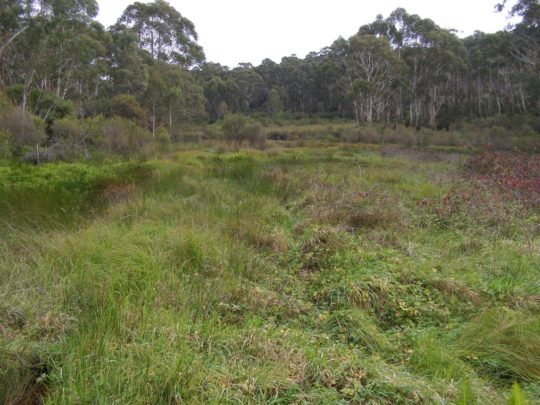
Bushcare Rehabilitation Site on a tributary of Katoomba Falls Creek
The Gully, Katoomba, Blue Mountains
This was allegedly ripped up by Blue Mountains Council to accommodate a marathon.
(click photo to enlarge)
.
‘The Gully‘ situated in the upper central Blue Mountains of New South Wales (NSW) is a natural creek valley surrounded by the township development of Katoomba, within a corridor and upstream of the Greater Blue Mountains World Heritage Area.
This valley has a disgraceful history of forced eviction of Aboriginal people from their traditional tribal lands by Blue Mountains Council in 1957, of environmental devastation to build a race track in the 1960s, of associated deforestation and commercial tourism exploitation, followed after the racetrack’s rundown and loan default, by many years of ecological neglect.
More recently, despite the efforts of members of the local community to rehabilitate degraded areas and eroded watercourses, a new threat has emerged – ‘Adventure Tourism‘.
Back in 2008, two separate organisations – AROC Sport Pty Ltd and The Wilderness Society NSW (an organisation which should know better) decided to launch respective marathons each through the Greater Blue Mountains World Heritage Area. They each proposed their respective marathon events with the government custodian of the World Heritage Area, the NSW National Parks and Wildlife Service and since both marathon courses also involved running through community land, they also approached the custodian, Blue Mountains (city) Council.
AROC Sport Pty Ltd proposed its Ultra Marathon with UK outdoor gear sponsor The North Face which it termed ‘2008 North Face 100‘ marathon – a 10okm individual marathon along walking tracks through the Blue Mountains World Heritage Area including through the magnificent Jamison Valley. The Wilderness Society NSW proposed a similar marathon termed ‘Wild Endurance 100 Blue Mountains‘, also a 100km team-based marathon along walking tracks through the Blue Mountains World Heritage Area including the Jamison Valley. Both events were publicised as being one off events, but have since become annual events attracting hundreds of competitors and spectators.
In January 2008, The Habitat Advocate learned that these two events had already been approved by the Regional Director of NSW National Parks and Wildlife Service (NPWS NSW), Geoff Luscombe, without apparently any consultation either with the Blue Mountains community nor with any conservation groups that have for many decades had a close association with the Blue Mountains and its conservation. [BMNP POM: “A Neighbour Relations Strategy will be developed to raise awareness about the park’s significant natural and cultural values, inform park neighbours about park management programs and encourage appropriate behaviour to minimise impacts on the park. Within the City of Blue Mountains, “neighbours” will include the whole community.”]
On 20080130, The Habitat Advocate wrote to the Blue Mountains (city) Council’s then Acting Bushland Management Project Officer, Ms Arienne Murphy, explaining our concern:
“The degree of environmental protection and safeguards for these affected natural areas that Council may be imposing upon the respective event organisers, and the trend of adventure tourism and elite sporting events using natural areas of high conservation value is one that warrants appropriate environmental safeguards, monitoring and a transparent decision making process.”
.
The Habitat Advocate requested from Blue Mountains (city) Council:
A copy of the user requirements including any standard terms and conditions that Council issues to (1) casual recreational license holders and (2) ongoing recreational license holders of Council-managed/controlled natural areas in the Blue Mountains Local Government Area.
A copy of the specific operating terms and conditions relating to the proposed Northface 100 and Wild Endurance marathon events both due to take place around Nellies Glen and through the Jamison Valley wilderness in May 2008.
.
The correspondence was ignored by Council and no information was received from Council.
At the time, The Habitat Advocate also raised similar concerns about the risks of damaging ecological impacts and of the unsuitability of these two events through the World Heritage Area with interested representatives of conservation groups – The Colong Foundation for Wilderness, the Blue Mountains Conservation Society, the National Parks Association of NSW, and the Nature Conservation Council of NSW.
Issues raised included:
To examine and improve the rule that regulate these events
To identify the location of high conservation value natural communities that the routes of each event propose to pass through
How the responsible custodian (NPWS NSW) proposes to ensure these communities are not adversely impacted
To protect and defend the important natural values of the Blue Mountains and the rare and threatened habitat of its flora and fauna.
The hold the NPWS NSW as custodian of the Greater Blue Mountains World Heritage Area to account under the Blue Mountains National Park Plan of Management (May 2001) [BMNP POM]and in accordance with its mottos of ‘tread lightly’ and ‘take only photos and leave only footprints’.
Ensure protection of wilderness values and adherence to a wilderness code of conduct to ensure “minimal impact codes or practices for potentially high impact activities including cycling, horse riding, adventure activities and vehicle touring” [BMNP POM, p.52]
.
A meeting was held at the office of the Colong Fondation in Sydney on Wednesday 20080206 between The Habitat Advocate, the above conservation groups and with Geoff Luscombe as well as with The Wilderness Society. The above concerns were raised with Mr Luscombe and he politely gave assurances that both events would not cause damage to ecology. The key document that would guide the conduct of the events and protect the ecology was the then ‘Interim Policy for Commercial Recreational Activities in National Parks of the Blue Mountains Region‘ (dated 20070926), by the then umbrella department of NSPW NSW, The Department of Environment and Climate Change.
However, no specific recognition, rules or guidelines were made to allow for commercial marathons involving large numver of participants and spectators within either the Interim Policy for Commercial Recreational Activities in National Parks of the Blue Mountains Region nor within the Blue Mountains National Park Plan of Management.
Indeed the Interim Policy includes clauses that run counter the large scale of two such commecvial marathons as per the following extract clauses:
.
‘Environmental Protection’:
.
Clause 5.1.11: “Commercial activities will not be permitted to lead to permanent or unsustainable impacts on the resource or become a significant proportion of visitor impact on a site or area.”
.
Slashed vegetation for the marathon through The Gully’s swamp, KatoombaBut what is the impact is occurring upon flora deep in the Jamison Valley Wilderness?Who monitors the marathons? Who is the watchdog over the custodian?
.
Clause 5.1.13 “The current Minimal Impact Bushwalking Code (Australian Alps National Parks) should be used by operators/guides as a minimum code of behaviour for all activities.”
.
[Ed. But under NPWS NSW Activity Agreement with AROC Sport, AROC Sport needs only..”Use best endeavours to ensure that participants adhere to the approved route on recognised and approved fire trails and walking tracks within the Park and do not deviate from these trails and tracks at any time.”]
.
Clause 5.1.14 “No modification to the environment, permanent or temporary, will be permitted (eg. fixtures or temporary caches) without specific Department approval.”
[Ed. So where is the NPWS NSW monitoring of compliance, or lack thereof?]
.
Cliff Walk slashed along the top of the Blue Mountains Western Escarpment to accommodate the North Face 100 marathon in 2008
(Photo by Editor 20080517)
.
North Face 100 participant runs through a Gully Bushcare Site, previously fenced off and sign posted
This riparian area was disturbed by Sydney Water in 2007 during its Sewer Amplification Project.
The site was subsequently rehabilitated with native plants by Networks Alliance in co-operation with local coucil and the local buschare group.
.
‘Recreation Management’:
.
Clause 5.1.21 “Commercial activities can only form a minor component of total use and not lead to the domination of a particular setting, site, route or activity, or unreasonably restrict or exclude the recreational opportunity of other users.”
Runners take right of way over bushwalkersWhat happens when the marathons are required to stay together in teams?
.
Clause 5.1.22 “Acceptable levels of use, in relation to the conservation and protection of the environment, will be based on precautionary principles determined by the Department and this process may not maximise commercial opportunities.”
Northface100 competitors – 1000 registered entrants an “acceptable level of use”?
.
‘Appropriate Activities’:
.
Clause 5.1.25 “Activities resulting in minimal impact will be preferred over those causing greater impact (eg. track walking versus off-track walking).” [Ed. No mention here about commercial marathons involving hundreds of participants]
Does my team have to stick together over the entire length of the trail? Wild Endurance: Yes. It is compulsory for the whole team to stay together the whole time. The team must arrive together and depart from each Checkpoint and also cross the finish line together. Of course if you are in the Relay event, then only half the team needs to arrive at each checkpoint and cross the finish line together.
.
.
Clause 5.1.27 “Where impacts associated with activities are high and sites are deemed suitable for recreational purposes, sites may be managed by the Department to provide for intensive use.” [Ed. No mention was made by Luscombe about any monitoring and enforcement by NPWS NSW]
.
Revisiting the Blue Mountains National Park Plan of Management:
.
The Service will continue to develop its Discovery interpretive program, including investigation of options for improving the quality, quantity and geographic spread of activities offered
The emphasis will continue to be on environmental interpretation and education and away from hard adventure.
Recreation Opportunities: Use by domestic and international tourists is largely day use concentrated on the scenic escarpment areas of the Jamison and Grose valleys, from Wentworth Falls to Katoomba and at Blackheath, although other relatively easily accessible areas are popular for adventure ecotourism (see section 4.3.8 Guided Tours and Commercial
Recreation).
With tourism in the Blue Mountains region projected to increase strongly over the next five years, the need to minimise the impacts of tourism on the natural environment is a growing concern.
Recreation use of the park includes a wide range of activities and is distributed throughout the park…Use is distributed throughout the year, with peaks during school holiday periods and long weekends.
The park is under increasing pressure from the growing number of park visitors, with some popular bushwalking and camping areas such as the Grose Valley, Wollangambe
area, the Wild Dog Mountains, Burralow Creek, Erskine Creek, Glenbrook Creek, Ingar and Murphys Glen showing signs of unacceptable environmental impacts.
Adventure activities such as canyoning, abseiling and rockclimbing have increased dramatically in 56 popularity, with visitation to one popular canyon having doubled over a two year period. These activities are associated with a proliferation of informal foot tracks which are eroding with increasing use. Vegetation is being denuded at popular abseiling and/or rockclimbing access points and public safety is an issue at some sites, particularly where there is conflict with other users.
Major management considerations include the need to raise awareness of visitor impacts, to monitor visitor use and, where necessary, to regulate visitor numbers to
protect the park environment, ensure visitor safety and maintain recreation experiences appropriate to a natural or wilderness setting.
Regulation of large groups, commercial activities and adventure activities needs to be considered in relation to both environmental impacts and public safety. Use of the park
by larger groups has the greatest potential to impact on the park. User conflicts, risks of accidents and injuries and impacts on natural and cultural heritage values all rise in
proportion to the size of the group.
The existing facilities have been developed over a period of more than a hundred years and are not necessarily compatible with existing design, safety and maintenance standards, may be having an unacceptable environmental impact and/or are inadequate to satisfy existing or projected recreation and tourism demand and patterns of use.
A major review of existing facilities is required and clearer priorities for maintenance and
upgrading of facilities or removal need to be developed to ensure that conservation and
recreation objectives can both be met in a management environment of limited
resources.
Natural areas: Recreation tends to be more dispersed and any facilities provided are relatively low-key compared to the developed areas, catering for a lower level of use.
Wilderness areas: This setting provides opportunities for solitude and self-reliant recreation.
Competitive activities including rogaining and orienteering will not be permitted in wilderness areas.
“The nominated area has a complicated border, defined partly by adjoining privately owned lands which, in the Blue Mountains Park section, also divides it into northern and southern sections along the corridor of the Great Western Highway. The heart of each Park is reserved as wilderness which totals 54% of the nominated area. ”
[Source: ‘Greater Blue Mountains (world heritage) Area’, United Nations Environment Programme, World ConbservationMonitoring Centre ].
The ‘Wild Endurance’ course map passes through the Jamison Valley Wilderness
.
. ‘NorthFace 100’ marathon course map passes through the Jamison Valley Wilderness
“Saturday 19th May 2012: The 5th Annual North Face 100 will begin at Leura’s Fairmont Resort in the Blue Mountains Australia.
Some 900 runners will embark on a 100km trail race which will take them through Jamison Valley, Narrowneck Plateau, Megalong Valley…”
.
Ed: Is this what custodianship of the Blue Mountains World Heritage Area has become – all about maximising visitation over conservation?
"We're coming to you from the custodial lands of the Hairygowogulator and Tarantulawollygong, and pay respects to uncle and grandaddy elders past, present and emerging from their burrows. So wise to keep a distance out bush."