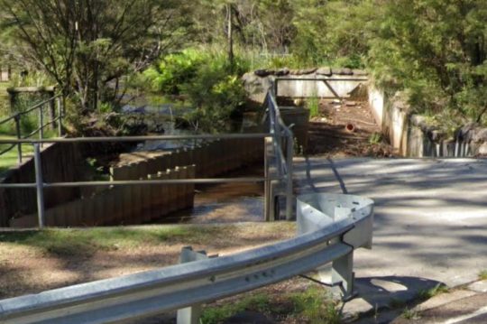
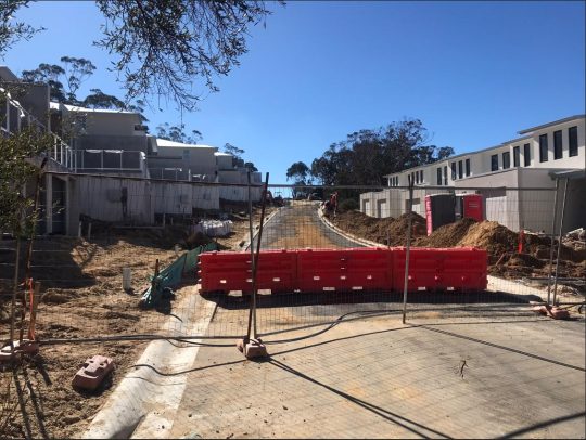
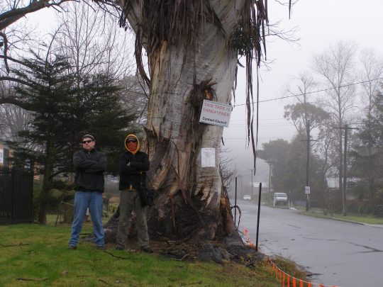
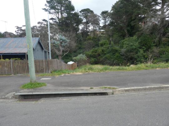
This is yet another example of neglected stormwater runoff maintenance by Blue Mountains {city} Council. Its in-creek water pollution trap (vane style) device is situated just above Katoomba Falls (left of photo).
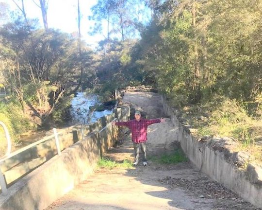
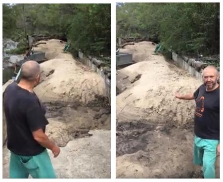
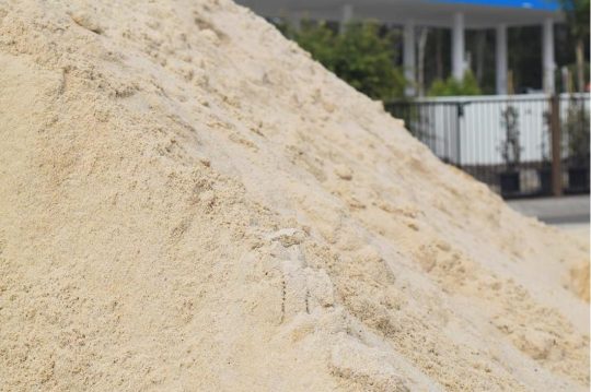
Our editor standing in front of large piles of sand pollution re-directed out of Katoomba Falls Creek by an in-creek pollution control device (left). [Photo by The Habitat Advocate, taken Thursday 30th May-2024.]
This pollution detritus trap has, from our very local experience over two decades, been typically full of destroyed native vegetation debris caused by (a) torrential rain events, and (b) bushland clearing (deforestation). It has also been observed typically full of siltation from (a) upstream creek bank erosion through Maple Grove, (b) from housing construction sand and graded topsoil, and (c) from unfiltered urban stormwater waste ignored by Council since it was established first as the Municipality of Katoomba in 1889.
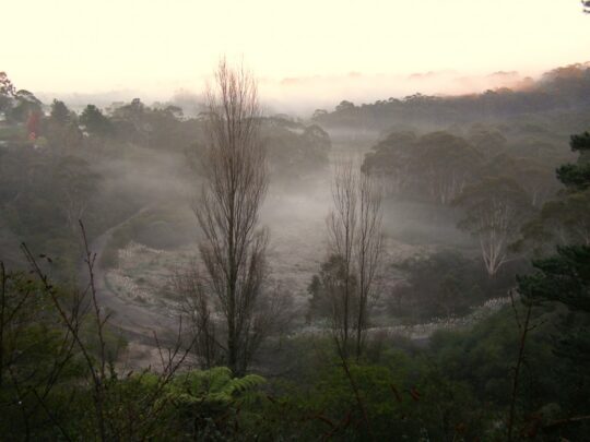
We have lived in The Gully Water Catchment since 2001. The Gully Water Catchment includes all land with watercourses and natural drainage flowing to Katoomba Falls, and we have taken a keen interest in this natural place.
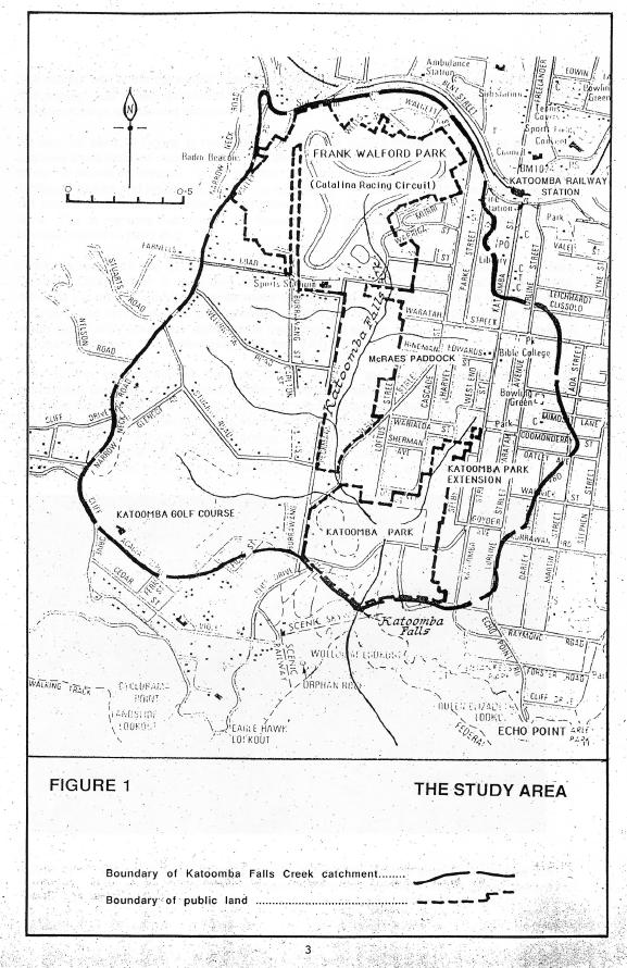
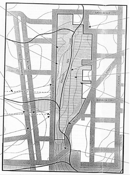
Katoomba Falls Creek Catchment as it was then called in 1993. [SOURCE: The Bell Report]
From our observed experience as local environmental activists, Council’s ongoing management culture is such that it focuses on the capital works projects, obtains external grant funding (usually from the NSW Government) but then fails to budget and resource the ongoing maintenance of such capital works projects. This Baramy Trap is another case in point.
We repeatedly observe this pollution trap full and overflowing for months at a time, so the trap overflows and the continuing detritus flows downstream into the downstream Kedumba River to supply Greater Sydney’s drinking water to Sydney’s artificial Lake Burragorang for Sydney and a Greater Sydney so scarily morphing beyond. Currently this pollution trap has been full of sand sediment for many months.
The above photo shows the concrete ramp down to the pollution trap for access by a small front-end mechanical loader designed to remove the sand and debris pollution into a waiting tip-truck.
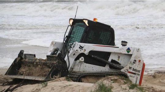
A Bobcat more suited to a construction site or at a beach as in this example photo. But at Blue Mountains {city} Council it’s Missing-In-Action.
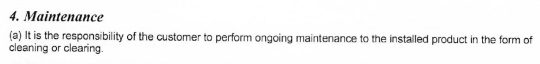
Council is supposed to maintain it and clean it out on an ‘as-needed‘ basis periodically, but it doesn’t. The following is an extract of Baramy’s terms and conditions for this pollution device once installed.
We obtained a copy of these terms and conditions back in 2004 when The Friends of Katoomba Falls Creek Valley Inc. (the Friends) sought a quote for a similar but smaller pollution device (4 m long x 2.1 m wide) previously to be constructed in the same creek further upstream. Baramy’s quote came in at $26,000 and we referred this initiative for action/grant funding to Council – it being the custodian of this community land and the creek water catchment. But Council ignored it.
In this case Council is the “customer” having paid to have this much larger device constructed by Baramy Engineering in this different location much further downstream. It would have cost Council double, constructed probably around 2005 from one’s memory.
Council’s culture
Council has form of having its other non-environmental priorities, such as its latest newfangled ‘Planetary Health Initiative’ to showcase its environmental stewardship, when it is just more greenwashing.
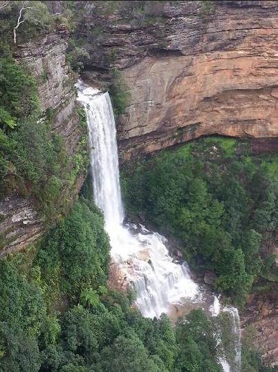
Previously, all such debris, sediment and stormwater pollution into the creek used to just flow over Katoomba Cascades and further downstream over Katoomba Falls into the Kedumba River below and southward through the Jamison Valley.
Katoomba Cascades during full flood, situated about 100 metres downstream of the pollution trap. [SOURCE: Photo by Brigitte Grant, in article ‘Flood photos: Three-day drenching’ 22nd March 2021, Blue Mountains Gazette newspaper]
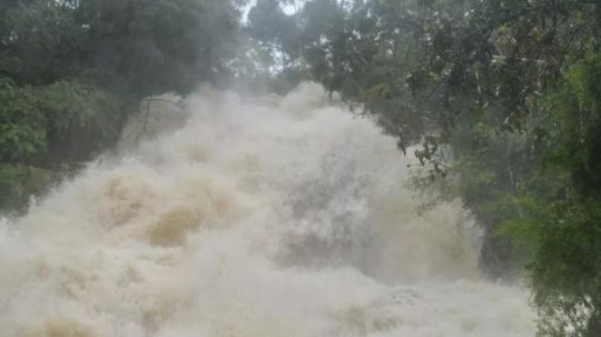
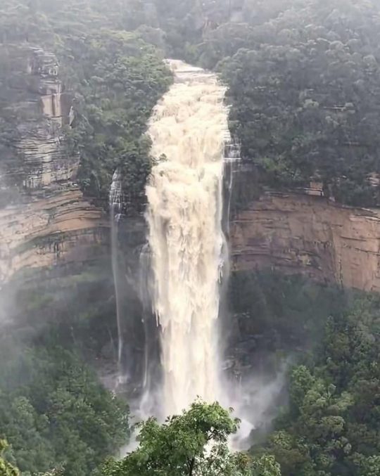
Katoomba Falls in full flood after days of heavy rain. The falls are situated about 300 metres downstream of the pollution trap. [SOURCE: Photographer unknown, in article ‘Police to co-ordinate evacuation of visitors trapped in Megalong Valley following landslip’ 4th April 2024, by Damien Madigan in Blue Mountains Gazette newspaper]
By the way, Upper Mountains sewage design (Katoomba, Leura, Wentworth Falls) back between 1907 and the 1990’s also flowed by iron piping down into the Jamison Valley to the former Leura Sewage Treatment Plant (historic image below) situated just by Leura Falls Creek between Echo Point and Sublime Point. The iron piping still can be seen along hiking tracks down the escarpment – the reason for the hiking tracks actually being first constructed.
We estimate that the current sand quantity filling this particular Creek Pollution Trap would be twenty cubic metres at least. We reported the problem to Council the day we took the first photo above – receiving Council’s Customer Service Request reference #533082.
We’re not the only locals having noticed this particular in-creek pollution trap full. Here’s another documented event of the very same pollution trap in February 2020. It was during the start of Australia’s East Coast Low events associated with the La Niña oscillating weather pattern:
Local Blue Mountains Aboriginal Gundungurra Elder, Mr David King, posting his video on Google YouTube protesting this exact same problem back in 2020. He even likened it Bondi Beach! [SOURCE]
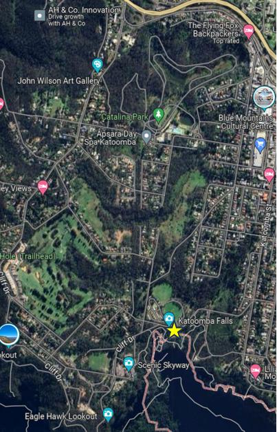
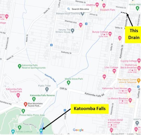
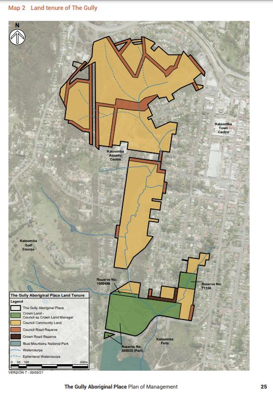
This pollution trap’s exact location is situated beside Cliff Drive in Katoomba on the southern (downstream) side of the road at the road culvert over Katoomba Falls Creek. See the aerial photographic map below showing the yellow star.
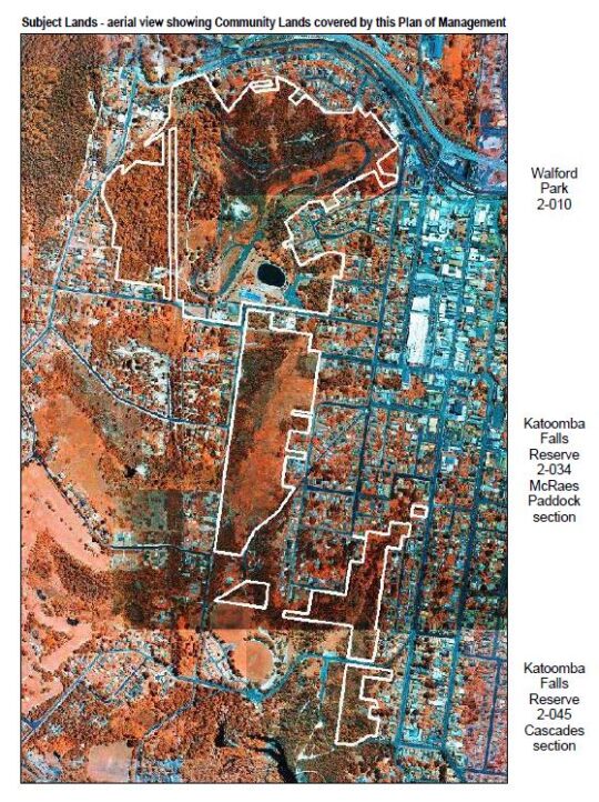
An aerial photo of the 100 ha extent of The Gully Water Catchment juxtaposed upstream of this pollution trap. (NB. The “Katoomba Falls” photo label is incorrectly shown on this image, being rather just a Google nominal reference on the roadside. [SOURCE: Google Maps aerial photo, 2024]
This in-creek pollution trap was constructed by Baramy Engineering Pty Ltd of Katoomba for Council.
The Baramy Vane Trap showing the two rows of vertical galvanised steel vanes in the creek line that divert debris to the concrete trap device on the right.
The construction timing was a few years or so following The Greater Blue Mountains Area (1 million km2) being inscribed on the UNESCO World Heritage list on 29th November 2000. Katoomba Falls flows into the Jamison Valley within this World Heritage area. The Jamison Valley, below these falls (and others) is also part of the drinking water catchment leading to Warragamba Dam supplying an ever-expanding Greater Sydney (current population approaching 5.5 million) adjoining the Blue Mountains region.
It is the researched opinion of The Habitat Advocate that this World Heritage listing was more about the human utility of protecting the value of Sydney’s drinking water in perpetuity, than it was about protecting the Eucalyptus forests of the Blue Mountains.
Katoomba Falls in the centre of this photo. The Gully Water Catchment upstream feeds natural and stormwater to these falls. The area covers an estimated 100 hectares a passes through a small valley up on the Blue Mountains plateau. This valley includes bushland and increasingly more and more housing development.
Notably, the sand type in this pollution trap appears to be not the naturally river sand, but consistently all the same light colour of Concrete Sand type used commercially in construction.
Concrete Sand
Concrete Sand is a coarser sand variety, pivotal in construction use to create strong and durable concrete structures. It’s typically made from crushed quartz, which gives it a rougher texture, enhancing the binding properties in concrete mixtures. This sand type is indispensable for laying robust foundations, constructing driveways, and forming sidewalks. This is exactly what is going on in The Gully Catchment upstream of this creek pollution trap.
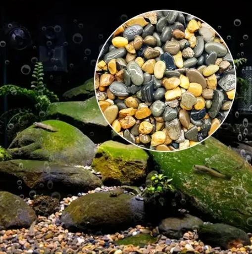
Whereas the natural creek-bed of Katoomba Falls Creek is comprised of small pebbles. This editor knows this from being local to Katoomba Falls Creek Valley and having voluntarily performed Streamwatch quality monitoring of Katoomba Falls Creek for five years (2004-2008) on behalf of the Friends of Katoomba Falls Creek Valley, Inc. reporting to the Sydney Catchment Authority (SCA) within the New South Wales Governments Sydney Water department.
An example of the characteristics of creek-bed pebbles typically found naturally on the creek bed of Katoomba Falls Creek and other nearby watercourses – yet sadly beneath the years of construction sand sedimentation pollution from various identified housing construction sites throughout this plateaued catchment.
Council doesn’t analyse the sand to determine its source. Council doesn’t fine the polluters and issue a stop work court order. Council doesn’t employ a hydrologist or geotechnical engineer on its books. Yet where is all the housing constrution taking place in the Blue Mountains? Upstream of the World Heritage area.
In our view, Council is unfit in delegated stewardship as custodian of the geographic plateau of the Blue Mountains Local Government Area (LGA) atop the Blue Mountains World Heritage Area from its atrocious record of failings. So long as this pollution control device is full and overflowing, sand and debris is flowing downstream over Katoomba Cascades and Katoomba Falls into the Kedumba River. Parks Service (‘NPWS’) doesn’t monitor pollution levels or water quality in Kedumba River down in the Jamison Valley.
Council doesn’t enforce sediment controls are housing development sites upstream in The Gully Water Catchment (Katoomba Falls Creek Valley).
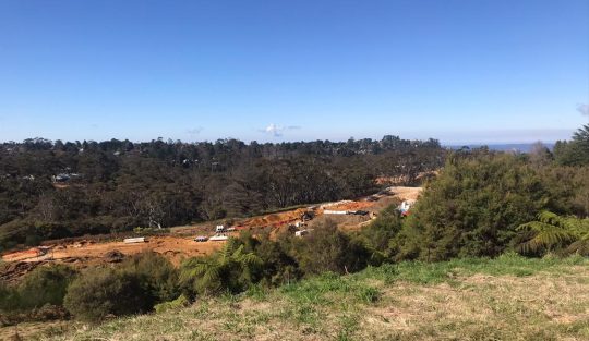
There are current two large housing subdivision sites contribution to sedimentation of the creek.
Some 13 odd hectares of fragile native bush surrounding an upland brook between Stuarts & Wellington Roads is to be bulldozed into a 53 cluster housing subdivision.
Bulldozing all the top soil throughout this side creek valley to Katoomba Falls Creek (Kedumba River). [Photo by Editor, Sunday 26th May 2024]
[5] ‘Pollution Control Device‘ quote prepared for ‘Frank Walford Park Bushcare’ (Friends of Katoomba Falls Creek Valley Inc), 2004-09-27, by Baramy Engineering Pty Ltd, 7 pages.
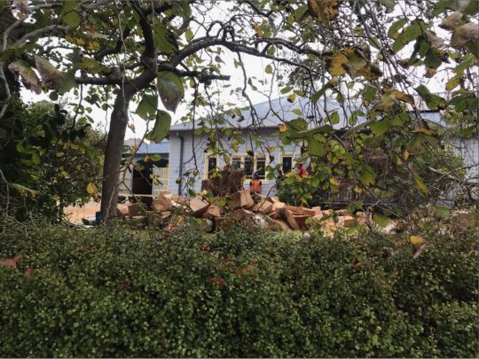
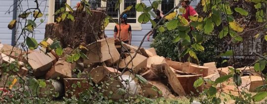
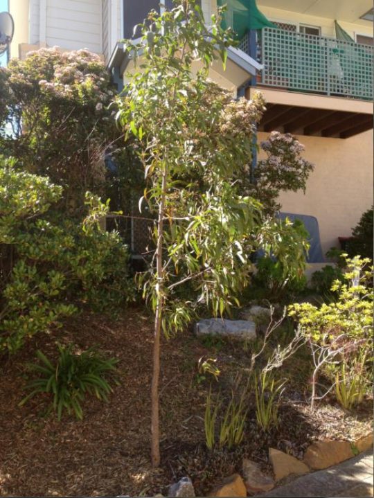
This large healthy mature native Eucalypt has just been chainsawed to death today. We could hear the noise of multiple chainsaws ripping reverberated around the neighbourhood from early this morning.
This tree grew on private residential land within The Gully Catchment on a large double block on the top of a prominent natural spur overlooking the northern part of The Gully not far from Horrie Gates’ old Catalina Dam.
The Gully is a valued small natural valley situated on the western edge of the township of Katoomba in the Blue Mountains of New South Wales.
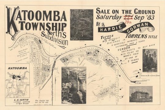
The particular site is zoned by local Blue Mountains Council as ‘Heritage’ and ‘Environmental Land’ under current Local Environmental Plan 2015. It is also a very old settlement area of the Blue Mountains dating back to 1876. In fact, it forms part of the oldest housing area of the Blue Mountains Local Government Area (LGA) and traditionally known as ‘North’s Estate’.
Land sale auctions advertisement from 1883
It was named after the first land Torrens Title owner John Britty North (1831-1917), an English immigrant during British colonial times who owned most of the immediate area and became a coal shale miner and then property developer there.
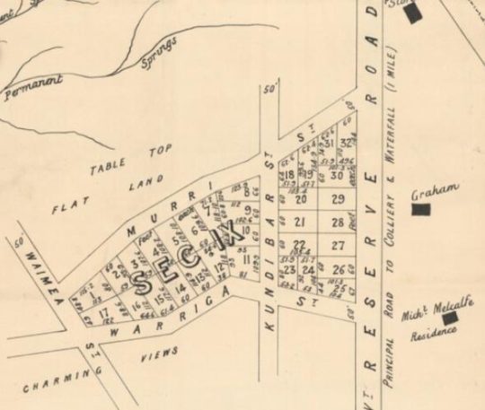
Close Up of the above map, the particular site is situated within ‘Sect IX’.
Recognition of this colonial heritage is such that this North Estate precinct has been especially zoned by council as ‘K171 – Norths Estate Conservation Area‘ under council’s LEP 2015.
Was Council permission sought? It appears from a call to Council, that it knew nothing about the owner’s plan to kill this significant native tree in this heritage and conservation precinct, as confirmed by CSR525105. Council used to have a Significant Tree Register to protect identified significant trees within its LGA. It no longer does.
So why kill it? It was a slight 5 degree lean but in the direction of the prevailing wind. Was it some perceived fear that in many years to come it might fall on the house? Was it a prejudiced fear of gum trees? For fire wood?
This native tree was probably over 100 years old, perhaps dating back to the 19th Century and was the most prominent specimen in the immediate area.
What was left of the tree this afternoon before the rain came again.
Yet this majestic native tree was in good health and vigour, and showed no signs of decay.
Close up: This tree was structurally sound. No dead wood from the tree can be seen in these chainsawed sections (‘body parts’)
Was any prior assessment by professionally qualified arborist conducted on the tree?
We recall back in 2014 with regards to saving the 300+ year old Eucalyptus oreades tree that local conservationists had dubbed ‘ATLAS’, that The Habitat Advocate contracted renown expert arborist (the late) Mr Fred Janes, to conduct a professional arborist appraisal and report on the relative health of ATLAS. This was sought because a property developer of the adjoining land wanted the tree killed by chainsaw so that he could selfishly have an overflow car park for the benefit clients of his proposed industrial estate complex. So he had secured a dodgy arborist, only licensed to use a chainsaw. Where as Mr Jane’s report found the tree to be in good health and vigour, and Council agreed.
We have observed over time since our own arrival in this special place in 2001, that whilst in The Gully’s ‘Aboriginal Place’ dissociated land parcels of native bush, the native trees within are culturally sacrosanct, as they should be; yet around the immediately periphery of adjoining private lands, housing development and deforestation continues incrementally. It is death by a thousand cuts transforming the natural valley into an artificial urban landscape.
This is why council insists on being called Blue Mountains City Council in its urbane dreams within a world heritage area.
‘ATLAS’? This is the worthy name our campaign branded this magnificent and extremely rare 250+ year-old Eucalyptus oreades that came under greedy developer threat. It is an endemic native tree estimated to predate Katoomba and indeed pre-date Captain Cook (that is pre-1770!)
About ‘Friends of ATLAS’
Back in 2014 at the start of spring in the Blue Mountains (Australia), Katoomba residents Maureen and Peter Toy from their home at 57 Megalong Street observed a man inspecting this magnificent tree on the verge out front. They approached the man, who then told them that he reckoned the tree was “diseased” and so had to be “removed” (aka killed).
The Toy’s campaign to save this magnificent tree was on in earnest!
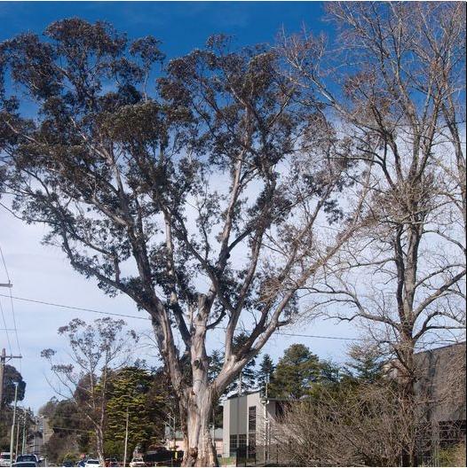
ATLAS survives in good health, not diseased, as a 250 year old (in 2014) native Blue Mountains Ash (Eucalyptus oreades), with a still-growing canopy of 40+ metres high.
ATLAS pre-dates the settlement of Katoomba. Indeed, ATLAS predates colonial settlement of Australian in 1788. According to a learned Grade 5 arborist with long experience in these species, ATLAS probably started growing as a sapling from the 1760s – before the French Revolution, before the American War of Independence, before James Cook first set sail from Britain to explore the Pacific and find the rumoured great southern continent in 1768.
This tree is an icon like the Three Sisters, yet hidden in Blue Mountains {city} Council’s assigned industrial area of Katoomba near the headwaters of Leura Creek and upstream of the popular tourist attraction of Leura Cascades and Leura Falls which tumbles into the Jamison Valley within the Greater Blue Mountains World Heritage Area.
According to advice the Toys received from local conservation consultancy The Habitat Advocate, this large Blue Mountains Ash (Eucalyptus oreades) is a native tree only found in the Upper Blue Mountains. Thousands of oreades were incinerated by the 2003 Centennial Glen bushfire, making the species now threatened in the upper Blue Mountains.
Maureen says:
“It is a beautiful and rare specimen and Blue Mountains folk are fortunate that we have such a significant tree still growing right by Megalong Street in industrial Katoomba. Over the many decades, this tree has withstood fierce windstorms, bushfires, (dodgy) road-widening and even industrial development all around it.”
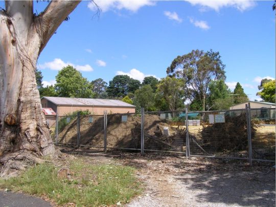
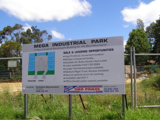
A new industrial development in 2014 was constructed behind ATLAS, replacing a old motor garage.
With a canopy about 40 metres high and a trunk girth of over 5 metres (measured at 1.4m above the ground ^SOURCE), the tree has become a recognised icon and reference point in the area. It is home to a large flock of Sulphur-Crested Cockatoos that roosts in the tree daily.
Campaign Background
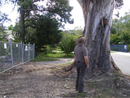
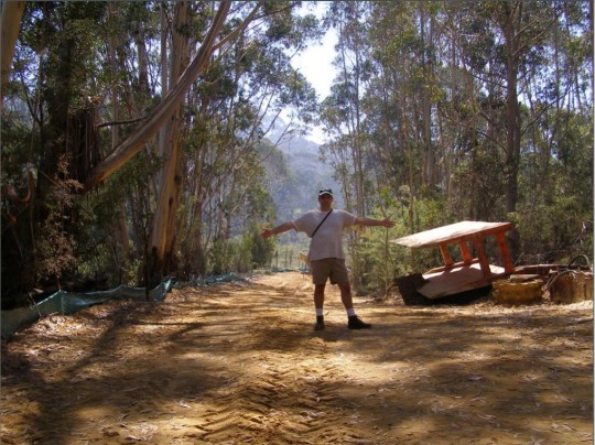
Some years prior in 2012, The Habitat Advocate’s Conservation Consultant Steven, had had his own concerns about the new development taking place behind the tree at 59 Megalong Street Katoomba, and decided to take some before-shot photos; the following three taken on 11th January 2012.
Our editor by ATLAS in 2012
So two years hence, with the new ‘mega industrial park’ constructed adjacent to the tree, the consulting arborist David Ford, whom Maureen and Peter had talked to, became the arch enemy to the preservation of the tree.
Peter couldn’t understand why the tree was NOT already listed on Council’s Blue Mountains Significant Tree Register or why anyone would want to harm it. The tree is situated on a community verge (Council-community land) and for the prior few years there had been an industrial development constructed behind it.
Peter and Maureen were vehemently opposed to any further harm being inflicted upon the tree and they have lodged a protest with council. Several others in the local community sided with the Toys and together formed an informal local community activist group ‘Friends of ATLAS’ – determined to save and protect this magnificent native tree. Their daughter Angelique started up an online petition to garner local community recognition and support to protect the tree.
Peter reckoned at the time:
“It’s early days but he is ready for a sustained fight.”
A fellow local supported commented:
“Dear Friends,
There is an emergency right now, to save one of the oldest Blue Mountain Ash trees that we have left.. The tree is now known as ‘Atlas’. You may well know this magnificent tree located at 59 Megalong Street, Katoomba. It has a girth of 5 metres and a growing canopy of 40 metres high. The tree has been estimated to be between 200 and 300 years old, I love this tree and hope you will help us save it 🙂
THANKS FOR YOUR SUPPORT
Peter H. Marshall”
A spokesperson from Blue Mountains {city} Council confirmed that the tree is situated on council verge land and not on the industrial development site behind. Research into the planning approval for the industrial development behind revealed that Council had stipulated in its development consent conditions that the tree must not be harmed by the development activity.
Though Peter disagrees. He says “guttering has been dug right into the tree roots system, then just a month ago the developer (behind) had a bobcat grade the topsoil and roots around the tree for an entire day!.”
Council’s spokesperson at the time clarified that council had not received any request for the tree to be destroyed. The community battle to save this tree from Council neglect and indifference was set to ensue.
Save ATLAS Campaign
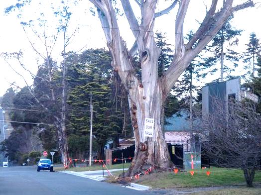
The Habitat Advocate took a particular interest in saving this tree shortly after noticing the sign on it ‘SAVE OUR TREE‘, placed there by Peter and Maureen in September 2014.
Our Conservation Consultant, Steven, had first observed the sign on the tree whilst a driver for Blue Mountains Bus Company as he sat in a bus in the depot one morning doing his bus pre-checks.
After his shift, Steven took a chance that the sign’s maker lived nearby and so knocked on the door of the house adjacent at 57. Peter and Maureen opened the door and the contact was established. [Editor’s Note: Peter and Maureen have long since relocated back to their home town in Western Australia].
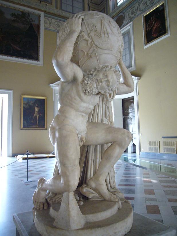
Steven suggested the tree deserved a name, as a brand for a public campaign to save it from being killed. Maureen affectionately called it the ‘Atlas’, after the Greek God, appropriately for its towering size and for be so enduring. In Greek mythology, Atlas was one of the most famous Titans, the son of Iapetus and the Oceanid Asia (or, possibly, Clymene). He was the leader of the Titan rebellion against Zeus, and he got a fitting punishment after the end of the Titanomachy: he was condemned to eternally hold up the sky. The etymology of the name ‘Atlas’ is from the ancient Greek word τλῆναι “to endure”.
This is a Roman statue of Atlas at the National Archaeological Museum of Naples in Italy. It is believed to be the oldest, dating from 2nd century AD.
Steven suggested a change of sign to generate more passerby interest, given that adjoining Megalong Street is a busy thoroughfare between the industrial precinct of Katoomba and Leura.
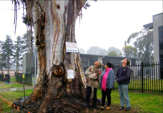
This new sign proved very effective. It reads: “THIS TREE IS THREATENED, Contact Council“. Many concerned locals indeed did contact Blue Mountains {city} Council to protest and demand what was going on. [Photo by Editor: Katoomba locals Maureen and Peter Toy, with Glenn Humphreys on the right, spring 2014]
“Threatened” was a play on words, since it had three meanings, intentionally.
Firstly, this flora species, a ‘Eucalyptus oreades’, is locally endemic to this small area of the Central Upper Blue Mountains, that is it is wildly found nowhere else on the planet and the species natural habitat and number of trees have been decimated by human deforestation since British colonisation of the area from the 1870s such that the remnant number of trees can almost be counted. This species and its ecological community is likely botanically deemed “threatened”, that is, it is likely to become extinct in the foreseeable future.
Secondly, this extremely large and mature, yet healthy specimen, could be more than 250 years old and so an even rarer example of the species. The number of such specimens growing in what once was their wild habitat may well be currently counted on one’s hands.
Thirdly, more imminent a threat is that the industrial developer who owns the site immediately behind this tree has intention of having it killed the tree in order to make way for some greedy notion of providing an overflow of customer parking on the verge outside his site.
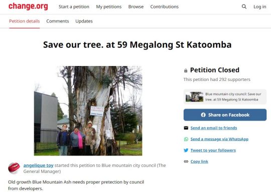
Peter Toy quickly set up a dedicated Facebook Page (now defunct) in September 2014, calling it ‘Friends of ATLAS’. Maureen and Peter’s daughter Angelique established an online petition on the Change.org website.
Garnering a community support base of nearly 300 individuals on a petition to save one important tree was one campaign success outcome
Fact Finding
As the publicity campaign to save the tree got under way, The Habitat Advocate considered some fact finding needed be done about the compliance of this development with Council’s conditions of consent, and in order to clarify the justification posed by the consulting arborist for killing this magnificent and otherwise healthy native tree.
Suspicions were that the arborist had assessed the tree on behalf of his client the property developer and had concluded what the developer wanted – the tree’s removal to make way for concrete paving of the Council verge to facilitate increased vehicle parking for the new industrial site.
Enquiries to Blue Mountains {city} Council confirmed that the development at 59 Megalong Street Katoomba was recorded by Council as ‘Industrial Development DA X/435/2010‘. A number of publicly available documents were obtained by The Habitat Advocate in relation to this development threat.
[Editor’s Note:
This habitat story is to be continued sometime in spring 2023, due to other pressing commitments that we currently have. The story shall be told in a number of parts discussing the SAVE ATLAS Campaign, its goals, strategy, opponents, supporters, relevant framework (planning and legal), research, publicity and ongoing updates. Unlike other attempts by Blue Mountains conservationists to save valued trees, especially endemic natives like this one, this conservation campaign succeeded and the campaign story shall provide not just a wonderful Blue Mountains story about a community coming together to protect natural heritage but also shall be instructive to others facing similar challenges of how to win against often overwhelming odds. Future parts to this story shall be posted in turn as a lead article on the front page of this website, The Habitat Advocate, which continues to be based in The Gully Catchment in the town of Katoomba since 2001. We thank our readers for their interest, support and patience].
We at The Habitat Advocate have lived in Katoomba in the Blue Mountains of Australia since 2001.
Situated on the western fringe of Katoomba, we continue to be closely connected with a small creek valley just below us observed outside our windows, referred to as Katoomba Falls Creek Valley, or by former residents simply as ‘The Gully’.
Katoomba Falls Creek Valley is situated within what we term ‘The Gully Water Catchment’. It is geographically less that 50 metres away from us, uphill on a spur from the Carrington. We observe the amphitheatre-shaped natural valley below and hear it within earshot and we greatly respect where we live and appreciate this area’s complex heritage.
In our mind, the historical and ancestral story of The Gully is a microcosm of the greater story of Australia’s colonial settlement saga. Whilst Australia’s colonial impost saga started from 1788 at Botany Bay then shifted to a fresh water source at Sydney Cove, The Gully’s saga started from 1815 when the Cox’s Road was driven through and then came land acquisition, deforestation, housing subdivision followed by coal mining by robber baron John Britty North who set the wrath from 1883.
The stories of the past of those before us and those current are vital and so to prevent a repeat of history, deserved to be told warts and all out there and everywhere; not greenwashed by mealy-mouthed government bureaucracy after closed door deals, eating canapes at PC publicity events. Raw on-ground truth must hold jurisdiction over political papered propaganda for any decent society.
‘The Gully Water Catchment‘ comprises the upland creek valley catchment of some (290 hectares/2.9 km2) above Katoomba Falls in the Blue Mountains. Over time since the 1870s it has been divided up for various human uses and abuses.
We are connected to this creek valley environmentally and have cared for its ecology and monitored various threats to it for now two decades. As a former member of local resident group activist group the Friends of Katoomba Falls Creek Valley Inc. between 2002-2007 we participated in voluntary Bushcare weeding and rehabilitation and in Streamwatch water quality monitoring.
We are connected politically. We have lobbied the land manager/custodian, Blue Mountains {city} Council since 2001 to secure this creek valley’s ecological protection and rehabilitation).
We are connected socially (we hold a close friendship with many local residents who live around the hilltop fringes surrounding this small creek valley.
We are connected personally (we hear and see the going on down there daily and we walk around it weekly).
We are connected historically having researched those who came before us, some who once lived down in this creek valley. We have researched local history of the area back to 1813).
Essentially, we think we know this small creek valley over the past 21 years quite intimately.
We respect where we live here, regarding this natural creek valley as the environs of our neighourhood; and as an extension of our home environment. To us and to many local residents, this is a beautiful natural creek valley; quiet, peaceful and with a sense of a peaceful welcoming sacred spirit. Our friendship with local elders (some of whom have since passed away) as well as our readings of historical research, confirm this. Since arriving here to call this place home in 2001, our family feels strongly connected to The Gully, like many of our neighbours.
But although we consider The Gully to now be our home after two decades, we are not so family or spiritually connected to The Gully as those who have come before us, who were here long before us but forcibly evicted by authorities. It was simply because they were too poor to protest and fight against powerful and wealthy outsiders who usurped The Gully for their own selfish ends.
The family and spiritual connection to The Gully by those who have come before us, extend back generations. Indeed, their stories and archaeological evidence shows back 14,000 years to this special place. We respect that.
Since various others refer to this creek valley and its many portions by other titles, and given various re-namings by local council over the years, for clarity we herein begin by explaining the various namings and their meanings as follows:
In summary, the portions of land of The Gully Water Catchment, including historically, and their relative sizes are:
The Gully Water Catchment (290 hectares/2.9 km2)
The Gully (northern section pre-1957) (50 hectares/0.5 km2)
Katoomba Falls Creek Valley (50 hectares/0.5 km2)
Upper Kedumba River Valley (50 hectares/0.5 km2)
McRaes Paddock (17 hectares/0.17 km2)
Catalina (amusement) Park (2 hectares/0.2 km2)
Catalina Park (motor) Raceway (50 hectares/0.5 km2)
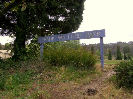
Frank Walford Park (50 hectares/0.5 km2)
Katoomba Park and Katoomba Park Extension (8 hectares/0.8 km2)
Built Up Residential Katoomba (within The Gully Water Catchment) (158 hectares/1.58km2)
21 Stuarts Road (single private land holding – a mixture of pasture and intact sedge swamp (12 hectares/0.12 km2)
The Gully – Aboriginal Place version 2004 Plan (66 hectares/0.66 km2)
The Gully – Aboriginal Place‘ version 2021 Plan (73 hectares/0.73 km2)
Gargaree‘ (a Gundungurra word for gully) (73 hectares/0.73 km2)
Why so many place-descriptive names for one little sub-catchment? Well, ask Blue Mountains {city} Council, since these place names and their renaming are of Council’s doing.
We notably observe that Council’s land area for ‘The Gully – Aboriginal Place’ in 2021 has expanded from 65.52 hectares since its 2004 Plan to 73 hectares in 2021. Why so? Has a miscalculation/estimate error occurred using different metric methods or software? “65.52 hectares” in its 2004 Plan is pretty darn accurate since down to 0.02 hectares covers an area of just 200m2, or 14m x 14m.
Seriously, is the public who have poor analytical/mathematical interests simply being conned by Council’s guesswork data?
These multiple place names for this creek valley have locally ‘evolved’ over decades to various portions by vested interests. This is confusing to outsiders to comprehend what is what. So from our local knowledge gained from living here for the past 20-odd years and from our passionate interest in researching to better understanding this place, we elaborate.
The Gully Water Catchment
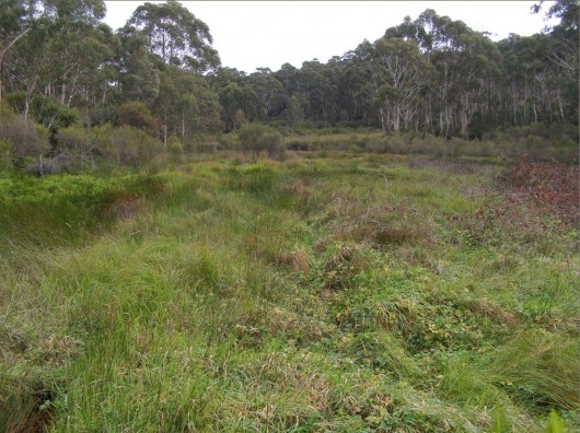
One of the headwaters of Katoomba Falls Creek. One of three StreamWatch water quality testing sites selected by The Friends of Katoomba Falls Creek Valley Bushcare Group [2003-2007]. (Photo by Editor 2011-04-01)
Given the field focus of The Habitat Advocate is ecology, for ecological clarity we shall herein refer to the entire valley catchment area with a hybrid title of ‘The Gully Water Catchment‘. We include the term ‘gully’ as a conciliatory recognition and respect to the former residents who used this term affectionately when they lived here before the racetrack land usurpation* of The Gully.
[Ed: *Usurpation is the act of taking somebody’s position and/or power without having the right to do this. Land Usurpation is the appropriation of land from the previous or lawful owner].
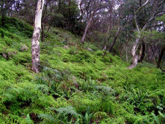
Ecologically, this creek valley is most importantly fundamentally a hydrological environmental system. The natural geography of this creek valley is characterised as an upper course riverscape, which takes the form of a south-facing naturally steep bushland amphitheatre shape in the northern portion of this valley. The valley lies about a thousands metres above sea level.
This area is defined as the entire water catchment area of 290 hectares/2.9 km2. The water catchment’s geographical boundaries comprise the Cox’s Watershed (Bathurst Road) to the north, Valley Road to the Jamison clifftop escarpment to the west, a meandering watershed though central Katoomba to the east and Katoomba Falls to the south.
‘The Gully Water Catchment‘ [SOURCE: Dr Val Attenbrow’s Map of 1993 as ‘The Study Area’, in Katoomba Falls Creek Valley Environmental Study | Draft Report and Management Plan prepared for Blue Mountains [city] Council | by F.&J. Bell & Associates | June 1993 | page 3 of 87]
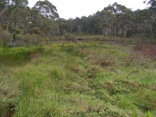
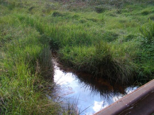
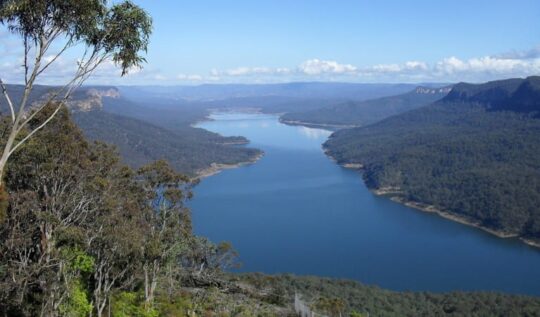
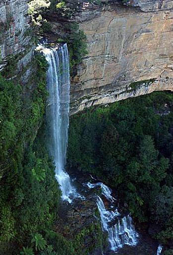
Rainwater that becomes surface water and ground water, flows from a small perennial waterfall and a number of springs which flow into several watercourses that confluence into the central creek with a native sedge swampland riparian zone leading to and surrounding the creek. The creek flows downstream southward over Katoomba Cascades and plunges over Katoomba Falls into the Kedumba River about 300 metres below in the magnificent Jamison Valley of the Blue Mountains World Heritage Area. Kedumba River then flows and meanders southward confluencing into the flooded Cox’s River and the artificial Lake Burragorang (constructed 1948-1960) which has since been Sydney’s primary drinking water supply.
Lake Burragorang (reservoir) is situated about 40km downstream south of The Gully Water Catchment [Photo on Wikipedia by Goran Has taken in January 2014, https://www.flickr.com/photos/goranhas/11897893604/ ]
This all means that indeed the relatively small creek valley on the western fringe of Katoomba forms part of an official drinking water catchment. But it is not just for the benefit of a distant growing urban Greater Sydney metropolis.
The Gully Water Catchment in its own right serves as a vital small natural ecosystem to sustain remnant locally native flora and fauna including aquatic macroinvertebrates throughout its creek riparian zone. This was despite the catchment’s history of land management abuse and neglect by local council and self-interested outsiders.
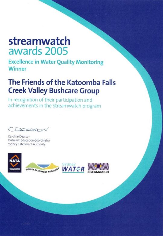
This author for five years between 2003 and 2007, as a former volunteer member of local community group the Friends of Katoomba Falls Creek Valley Bushcare Group (‘The Friends’ for short) undertook regular water quality monitoring and testing of three test sites of this creek under the instruction and resourcing the then Sydney Catchment Authority’s Streamwatch Programme.
‘Citizen science’ indeed!
Our group proudly won five awards over this time for our efforts including this one below in 2005. Our winning award was a recognition by the Sydney Catchment Authority for our specific work in monitoring, testing, investigating and reporting incidents of sewer overflow pollution of the creek from Sydney Water’s sewer network in the valley.
As part of our win, Sydney Catchment Authority rewarded our StreamWatch group with a $2000 cheque thank you.
Fresh flowing water has always been an integral value of this small creek valley. It is not just that it is part of the Kedumba River Water Catchment that supplies drinking water to Sydney, but vital to restoring the local riparian ecology.
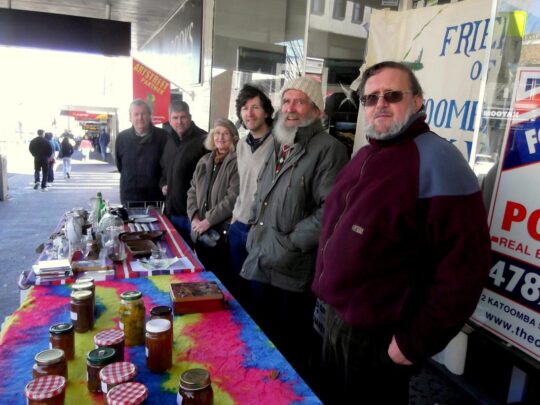
At the time our volunteer charity group The Friends subsequently invested this $2000 into a fixed interest account, since its operational expenses continued to be funded by our street stalls in Katoomba Street. Ultimately, upon the sad passing of the founder and chairperson of The Friends on 26th May 2016, The Friends elected to formally wind up the incorporated organisation. These funds along with the balance of the operational bank account were then gifted to the Blue Mountains Historical Society as part of a successful handover of The Friends archival records spanning 27 years.
Over two centuries, government in NSW (both state and local) continually re-zoned and divided up The Gully Water Catchment from being a pristine natural water catchment into various ‘sold out’ portions, thus.
The New South Wales colonial government’s land usurpation of Aboriginal country west of Sydney for colonial settlement since the British colonial explorers’ crossing of the Blue Mountains in 1813
Government sales of the Blue Mountains plateau lands around what is now Katoomba and Leura (including this creek valley) to various colonial settlers who subsequently deforested the land for timber, cattle and horse grazing and for town building and associated housing subdivision
The acquisition of this creek valley and surrounding land by one John Britty North [1831-1917] in the 1870s for subsequent deforestation, housing subdivision and then for coal mining exploitation to the south
John Britty North’s Katoomba Coal Mine’s coal shale tramway corridor (3 metres wide along the western ridge of the valley since the 1870s from the Jamison Valley escarpment (where Scenic World is located) to a rail loading platform called North’s Siding near the corner of Valley Road and Bathurst Road (next to what locals call ‘Shell Corner’ – where the Shell servicestation used to be situated, currently Bohman Automotive repairs.)
Incremental sales of bushland by Council for housing subdivisions along with urban streets over many years since the 1880s
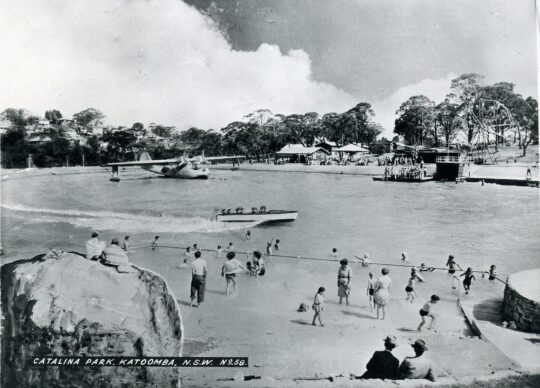
Catalina Park amusement park and lake [1946-1951]
Council’s subsequent purchase of the land of Catalina Park in 1952
Catalina Park motor racing circuit leased by Council to the Blue Mountains Sporting Drivers Club Ltd [1957-1971]
Council’s aquatic centre constructed in Katoomba Falls Creek valley in the 1980s
Two Council cricket ovals at Katoomba Reserve
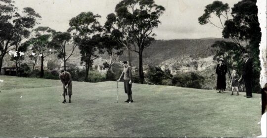
Katoomba Golf Course [1911-2013]
Council’s rezoning and subdivision approval of ‘The Escarpments’ townhouses on a portion of the Katoomba Golf Course site (2000 – current)
Council’s caravan park (currently called ‘Katoomba Falls Tourist Park’)
The NSW Government’s Rural Fire Service’s South Katoomba RFB Station with subsequent access roads
The NSW Government’s Rural Fire Service’s Bushfire Control Centre built near the aquatic centre below Mission Street
As a secret waste dump for hundreds of tonnes of sand and rock on top of the swamp extracted from the RTA’s Great Western Highway cutting between Blackheath and Mount Victoria
The areas previously gazetted by Council as Frank Walford Park, Mc Rae’s Paddock, Selby Street Reserve and Katoomba Falls Reserve have in piecemeal been handed over to Gundungurra (Aboriginal)-only custodianship as ‘The Gully – Aboriginal Place’ in 2002
Council’s proposed ‘Centre for Planetary Health’ to occupy the defunct golf course clubhouse from 2022
This list is not complete.
The remnant natural bushland portions of The Gully Water Catchment continue to be steadily sold off periodically by Council (along with many other bushland blocks owned by Council in order it seems to bankroll Council’s annual operations and councillors’ capital works indulgences – external consultants, legal fees, media public relations, over-paid executive management, and unnecessary capital works projects.
The Gully
‘The Gully’ is the old affectionate name given to this creek valley above Katoomba Falls and in particular to the northern portion by its former residents (numbering two or three dozen or so) who lived there for decades from the early 19th Century first contact with British colonial settlers. This was until the last residents were forcibly removed from the gully 1957-1959 by Council and their homes demolished by contracted bulldozer.
“By May 1959, the shacks of the last Gully residents had been all demolished to make way for the Catalina Racing Circuit which officially opened in 1961. “
– John Merriman, Blue Mountains historian.
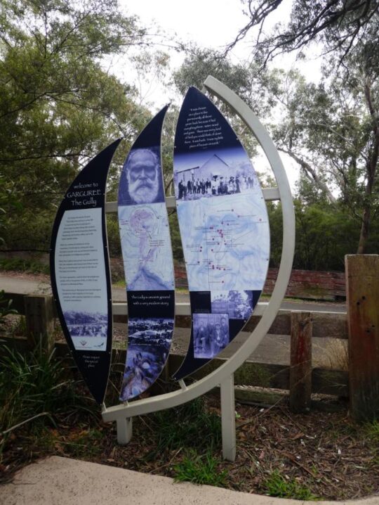
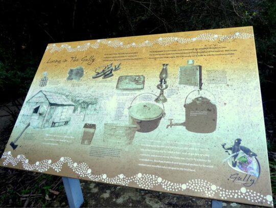
Aboriginal interpretative sign of 2008 positioned at the entrance to The Gully. It briefly outlines the record of former residents who lived there before the racetrack land usurpation of The Gully.
Those residents comprised both locally Aboriginal clan families, comprising predominantly people of Gundungurra and Darug ancestry as well as non-Aboriginal, many of whom had inter-married. It had been a tight-knit self-sufficient yet quite poor community refuge of displaced persons, subsisting in bushland typically in meagre dirt-floor shacks with no utilities (i.e. no connected running water, electricity, gas, plumbing, phonelines or streets).
It had been simple bush living refuge of poor folk subsisting on the fringe of Katoomba of both regional Aboriginal, non-Aboriginal and a intermarried mix of both. Many had been previously displaced in 1948 from their Burragorang Valley bush homes when the NSW government evicted them to flood the valley to create a Sydney’s Warragamba Dam reservoir. The Gully was a close-knit community.
It holds archaeological evidence thanks to field research separately by Dianne Johnson, Ph.D (2001) and Alan Lance (2005) which confirm ancient Aboriginal archaeological sites within the gully extending to ancient origins, extending back as far as 12000 years.
The Gully in the old days (early 1800s to the 1957-59 forced eviction by Blue Mountains {city} Council.
But The Gully people must have had sewage since around 1907 when then Katoomba Municipal Council had trenched up the valley for sewage to flow to the ‘Leura Filter Beds’ via the escarpment around Katoomba Falls and situated down in the Jamison Valley. Remnants of the long disused iron sewer pipe infrastructure may still be seen along on the hiking track between Katoomba Kiosk and the Furber Steps access down into the Jamison Valley.
Before colonial settlement, The Gully had been a traditional ‘summer camp’ location used by regional Aboriginal peoples for meeting and ceremonial place of traditional Aboriginal peoples of the Gundungurra, Darug, Wonnarua, Wiradjuri, Darkinjung and Tharawal of the greater Blue Mountains region and adjoining lands. This was usually is the warmer times of year and this connection to country. Particularly appealing to these traditional people was the constant and reliable supply of fresh flowing spring water and the abundance of bush tacker and wildlife to sustain a small community.
‘The Gully Bringing Back the Sweetwater’, by former residents of The Gully and descendants.
[Source: Blue Mountains {city} Council]
Katoomba Falls Creek Valley
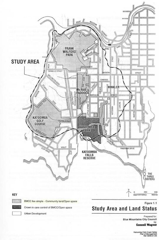
Katoomba Falls Creek Valley was long the gazetted name of this creek valley by local council for decades throughout the 20th Century. The following map shows some identified sub-portions of the creek valley juxtaposed within the black dotted line of the overall water catchment, flowing to Katoomba Falls to the south.
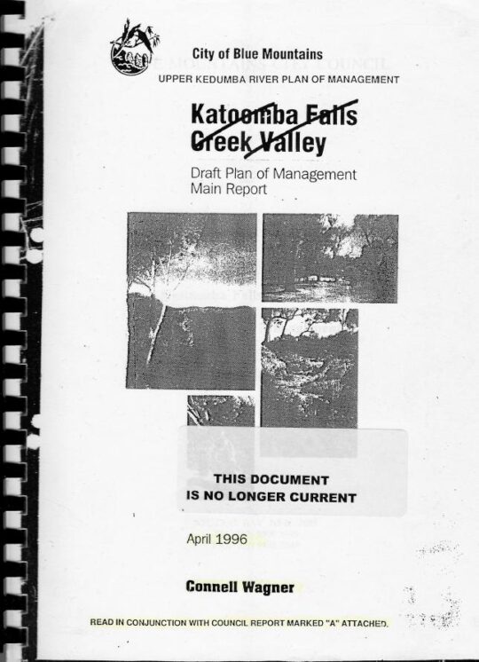
Katoomba Falls Creek Valley – Study Area and Land Status, Draft Plan of Management, (renamed by Council as Upper Kedumba River Plan of Management), by Connell Wagner April 1996.
It was affectionately referred to simply as ‘The Valley’ by surrounding residents’ grassroots environmental group The Friends of Katoomba Falls Creek Valley Inc. (The Friends) which functioned to respect and rehabilitate its natural values and ecology as informal ecological custodians and to challenge the many damaging threats to it by various vested outside interests between the years 1989 and 2016; some 27 years.
Katoomba Falls Creek Valley was the historical name of the full length of this creek valley water catchment up until 1995.
The following recent YouTube video shows the downstream water emanating from this creek valley flowing over Katoomba Cascades and then down Katoomba Falls.
Upper Kedumba River Valley
In 1995 Blue Mountains {city} Council unilaterally decided to rename Katoomba Falls Creek Valley as ‘Upper Kedumba River Valley‘ without local community consultation. One presumes that Council’s renaming logic was because this the central creek flows of this upland valley flows to Katoomba Cascades and over to Katoomba Falls into the Kedumba River more than 300 metres down in the Jamison Valley below, so it seems that some bureaucrat in Council wanted to continue the name to the small creek above the falls.
The renaming suggests Council’s recognition of this upland creek valley as being part of the water catchment area of the Kedumba River below Katoomba Falls and through the lower Jamison Valley. One suspects that given Council’s decades of fighting against the wises of local community environmental activist group The Friends of Katoomba Falls Inc. and that the renaming of the creek valley was a snide attempt by Council to undermine the validity of this group.
Compare the following two documents below. The second shows the original name crossed out by Council.
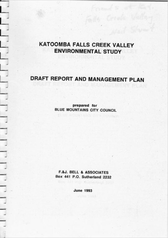
This study and report by Fred Bell and his environmental consulting team was commissioned by The Friends at a cost of $10,000. It was formerly submitted by The Friends to Council, but was wholly ignored by Council bureaucracy and the councillors at the time. A full transcript copy is made availabe on this website at: https://www.habitatadvocate.com.au/gully-report-1-the-bell-report-of-1993/
This subsequent report was commissioned by Council at ratepayer expense and prepared by Sydney based consulting firm (in Neutral Bay) Connell Wagner and probably at considerably higher cost – not their money.
Council’s 1996 plan of management was pretty much a copy of Fred Bell’s 1993 plan of management for The Friends. Both plans considered the entire water catchment and recommended similar environmental restorative actions be undertaken. It didn’t happen.
As a former member of The Friends, this author recalls that when the group learned of the renaming on Council’s 1996 plan of management title, the group chose not to change their name. Affectionately the members just referred to the entire water catchment simply as ‘The Valley’ for short anyway.
What is so hypocritical of Council’s recognition of this upland creek valley as forming the upper reaches of the water catchment area of the Kedumba River, is that over the decades both state and local government have repeatedly divided up the contiguous water flowing nature of this creek valley in various ways. This includes rezoning various portions of the land from being gazetted as ‘community land’ to being ‘operational land’ so it could be re-purposed and exploited. This dates from the colonial 1870s and continues with Council’s most recent culturally exclusive plan of management of 2021.
Land use development examples include:
James Henry Neale’s subdivision and lobbying from the 1870s to build what has become Katoomba township
John Britty North’s adjoining subdivision and joint lobbying for housing and coal shale mining access from 1883
Various housing subdivision approvals by Council since
Horace Gates Catalina (amusement) Park and dam construction 1946-1951
Council’s sewer network trenching throughout The Gully to facilitate further housing subdivision
Blue Mountains Sporting Drivers’ Motor Racing Club Limited’s motor racing circuit [1957-1971]
Two Council cricket ovals
Council’s aquatic centre – which keeps getting bigger
A bushfire brigade building, hardstand and two access roads
Hundreds of tonnes of sand and rock dumped from a highway development (at Soldiers Pinch) on The Gully’s swampland by the RTA in 2001 (with Council approval)
Sydney Water’s dumping of hundreds of tonnes of sewer fill in The Gully in 2005
Scenic World’s Skyway development in a secret land swap deal between the Parks Service and Council [2006]
Sydney Water’s sewer amplification trenching [2007-2008] to facilitate further housing subdivision
About a hectare of sand and rock fill (1 metre thick) was dumped on top of The Gully swampland by the Roads and Traffic Authority (RTA) in 2001. The RTA has since been rebranded RMS and current TfNSW, probably to avoid its bad reputation.
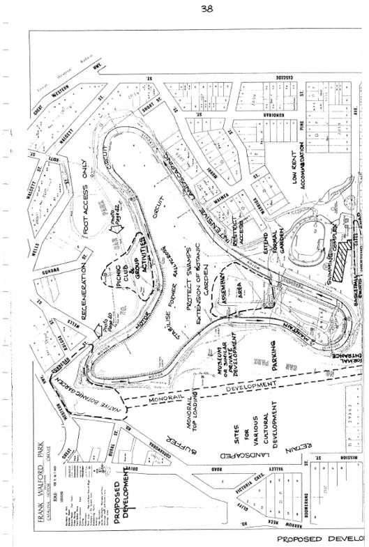
This is just to name a few, and this doesn’t include the many hair-brained proposals for The Gully over the years, like an ice-rink, basketball courts, Scenic World’s cable hang-gliding and flying fox, a complete housing subdivision to be called ‘Highmark’, low-rent accommodation, a museum, and even Katoomba’s own mono-rail! Study Council’s 1981 Plan of Management map below.
The Gully’s legacy of exploitation exemplified in Blue Mountains {city} Council’s 1981 proposed development Plan of (mis)Management, page 38.
The word ‘Kedumba’ is has Aboriginal origins and is just a variation of the word ‘Katoomba’ depending on how it is pronounced. The original meaning was supposedly “tumbling waters” in reference to Katoomba Cascades and Katoomba Falls below.
Katoomba Falls
Another theory espoused by local Blue Mountains historian Jim Smith Ph.D. is that ‘Katoom-ba‘ could have been a local aboriginal Gundungurra phrase relating to the pointing to a certain edible ‘fern: ‘Katoom’ (the fern plant) and ‘ba’ (over there) down in the Jamison Valley. We like the tumbling waters version.
Blue Mountains {city} Council has since renamed Upper Kedumba River as Kedumba River on Google Maps:
Council renamed Katoomba Falls Creek as Kedumba River. Seriously, has Blue Mountains {city} Council bureaucracy got nothing better to do than indulge in ‘cancel culture’ renaming of local geography?
McRae’s Horse Paddock
This middle portion of the creek valley used to be colloquially called by locals as McRae’s Horse Paddock possibly in the post-WWII days of nearby Catalina Park.
This portion comprises the riparian zone and bushland either side of Katoomba Falls Creek extending southward downstream situated south of Gates Avenue in the north, to Neale Street in the south and east of Peckmans Road in the west as the following map shows. It excluse the lands already sold off by Councik for residential housing in the east along Loftus Street.
McRae’s Paddock map, in McRae’s Paddock Action Plan (1996-1999) in Katoomba Falls Creek Valley Draft Plan of Managamnt Main Report, prepared for Blue Mountains {city} Council by Connell Wagner, April 1996. (no page number)
McRaes Paddock (as it has become abbreviated by Council) is characterised as a narrrow riparian swampland corridor midway along the valley creek that extends from being channeled as a drain culvert underneath Gates Avenue and then south for about 800 metres to being similarly channeled as a drain culvert underneath Neale Street.
The creek corridor at this creek valley portion narrows from about 200 metres wide to 100 metres at Neale Street, and the approximate remnant swamp/bushland area not yet been encroached upon by housing, covers about 70 hectares (or 0.7 km2).
Anecdotal local oral history records that the land owner was a grazier by the name of McRae (Scottish heritage spelt ‘Macrae’) who grazed his horses in this ploughed up swampland and the surrounding natural grassland either side of the comparatively narrower section of this creek valley.
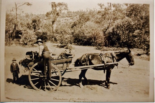
Prior to the use of this area as a horse paddock, it had been utilised for market gardening as old photos reveal.
Jimmy War Sing, a Chinese market gardener (circa 1903) of this creek valley area from which the swamp has been ploughed up and soil brought in.
Over the decades post-WWI, Gully locals shortened the name to just ‘McRae’s Paddock’ and the name stuck. The surname has Scottish ancestral origins, the ‘Clan Macrae’ being a traditional Scottish highland clan, however the origins of McRae’s Horse Paddock are not know to us, yet, but give us time with our ongoing research for this website.
Catalina (amusement) Park
Post World War II, between 1946 and 1951 local Katoomba tourism entrepreneurial businessman, Horace Gates, established an amusement park in the valley (The Gully) that, with support from local council aldermen, he named Catalina Park.
However not long after, by 1951 Horace Gates had lost patronage for his amusement attraction and the venue fell into disrepair. In 1952 local council acquired his land in the valley.
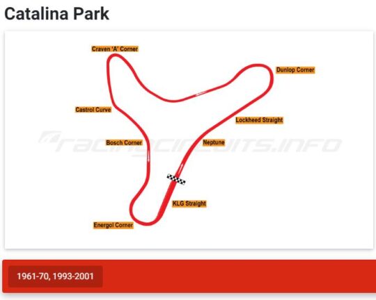
Catalina Park Raceway
At this time, Council had hiked up the land rates of properties across the Blue Mountains including those in this creek valley. It was in order to fund Council’s then utility obligations in a growing need for sewage, electricity and road making. Over more than a decade post-war, Council had forcibly acquired many bushland properties that had been investment block of private land holders due to the repeated non-payment of Council’s increasing rate hikes, outsourcing the legalities to the Katoomba legal firm Soper Brothers. By 1957, Council owned most of The Gully.
During the 1950s motorcar racing had become very popular in Australia and particularly with local businessmen in the Upper Blue Mountains who had bought racing cars and wanted to test them out and to compete with one another. Numerous small motorcar garages established and there became a growing motorcar racing fraternity. They registered as as company as the Blue Mountains Sporting Drivers’ Club Limited.
Their short uphill car races became popular, usurping various steep local streets of Katoomba and their power and influence evolved into them lobbying Council for a dedicated local car racing circuit to be established in the Upper Blue Mountains.
The Blue Mountains Councillors obliged on Tuesday 2nd April 1957 by passing the following motions thus:
SOURCE: Council of The [city} of Blue Mountains councillor special meeting minute 447 (c), page 216, dated Tuesday 2nd April 1957.
And then on the same day:
SOURCE: Council of The [city} of Blue Mountains councillor special meeting minute 450, page 216, dated Tuesday 2nd April 1957.
So between 1957 and 1959, Blue Mountains [city] Council proceeded to forcible evict the residents of The Gully and demolish their homes in order to appease these influential businessmen and to construct a motor-racing racetrack circuit in the northern amphitheatre portion of this creek valley. Council funded the racetrack construction by way of a loan to the Blue Mountains Sporting Drivers’ Club Limited, using ratepayer moneys. That loan was never repaid.
The usurping motor racing fraternity then called the place ‘Catalina Park‘, named after the float plane that had decades earlier been positioned in an artificial dam alongside the creek as an amusement attraction.
This is the name that Blue Mountains {city} Council gave to the northern portion of the creek valley which forms a natural amphitheatre shape and covers about 80 hectares. In the 1990’s, following the demise of Catalina Park racetrack, the government landowner of The Gully, councillors on the Blue Mountains {city} Council unilaterally named this northern portion of the creek valley after one of their own, former alderman Frank Walford [1882-1969] who was also the local mayor on three occasions.
Frank Walford was from Sydney and settled in Katoomba from 1919 just after The Great War where he worked as a journalist with the local newspaper The Blue Mountains Echo and became its editor. He was a keen and experienced bushwalker, bushman, mountaineer a variable adventurer. He became an accomplished author of novels and poetry.
As alderman and mayor he was largely credited (accused by former residents of ‘The Gully’) as being largely responsible for approving the motor racing circuit in 1957 in this portion of the creek valley. However, while he supported the race track construction, Council records show that he was not mayor at the time in 1957, but an alderman.
The park sign off Madge Walford Fountain car park just by Lake Catalina. It was moved likely by Council sometime around 2014. Madge was Frank’s wife. [Photo by Editor 2007-10-27]
Frank Walford Park is bounded by a steep bushland amphitheatre up to the surrounding ridgeline along where Lower Wells Street borders to the north, where Valley Road and Mission Street borders to the west, where Cascade Street borders to the east; and to the south where Gates Avenue, Catalina Avenue and Farnells Road. There is also a spur-line that juts into the valley from the east which includes the residential streets of Murri Street, Waimea Street and Warriga Street.
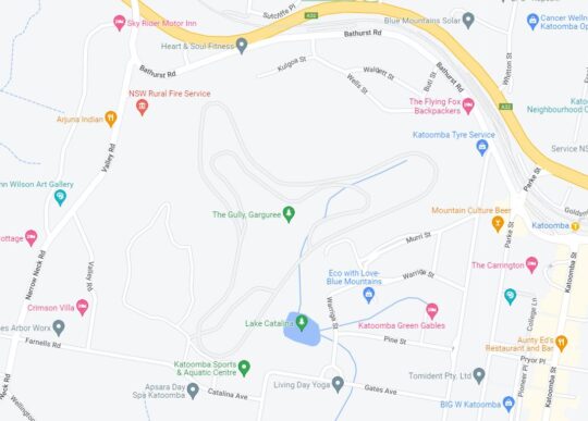
The surrounding street map around Frank Walford Park. [Google Maps, 2022]
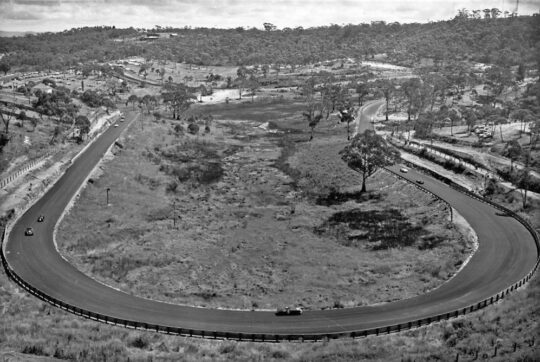
It was the broader gazetted land area of the creek valley around which the 1940s amusement park ‘Catalina Park’ centred around the artificial lake was constructed by Horace Gates and later from 1957 where the 2.1 km ‘Catalina Park’ motor racing circuit was constructed by the former Blue Mountains Sporting Drivers’ Club Limited.
Probably a key justification for Council’s naming of Frank Walford Park after Frank’s passing in 1969 was because his home with his wife Madge was situated close by in an 1880s stone house up on the eastern spur-line overlooking Dunlop Corner at 6 Kundibar Street in Katoomba. Frank and his wife became a fan of the motor racing so much so that during the circuit’s peak operation in the 1960’s Frank had a second storey added to their the stone house as well as a small balcony so they could better watch the car racing especially from the starting grid up Lockheed Straight and left around the sharp Dunlop Corner.
Dunlop Corner of Catalina Park (anti-clockwise) motor racing circuit circa 1965 looking west from up near Katoomba Tyres on Cascade Street. Frank Walford’s family home was located left of the photo, uphill on the spurline above the racetrack. With all the trees cleared by Council, Mayor Walford created an uninterrupted view from his new upstairs balcony. [SOURCE: Blue Mountains Local Studies, ^https://www.flickr.com/photos/blue_mountains_library_-_local_studies/33414945591/]
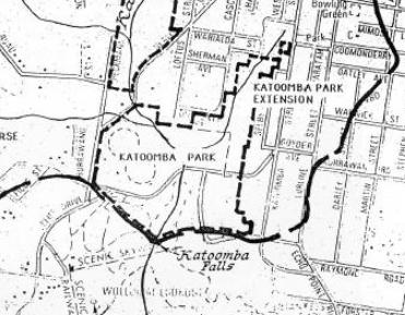
Katoomba Park (and Katoomba Park Extension)
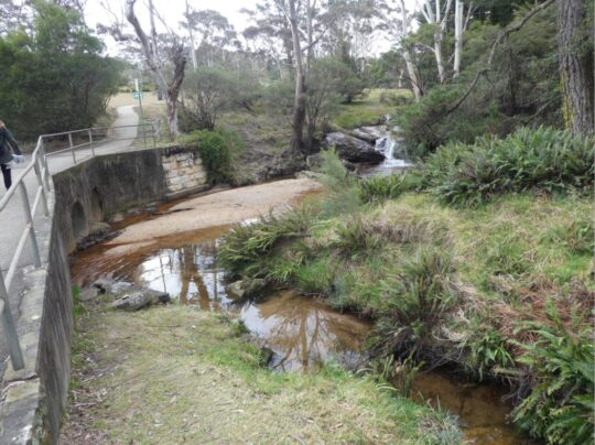
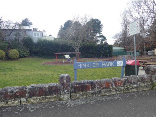
This comprises the southern portion of The Gully Water Catchment between Neale Street and to the Jamison clifftop escarpment around Katoomba Falls. It includes the two sports ovals primarily used for local cricket during the summer months, as well as the caravan park called Katoomba Falls Tourist Park. It also includes the riparian zone along the eastern tributary that has its headwaters at where Hinkler Memorial Park is situated and flows through Selby Street Reserve and alongside Council Maple Grove tourist picnic area. This water course confluences into the main creek just near the road bridge at Cliff Drive.
The confluence of Katoomba Falls Creek (Upper Kedumba River) and the eastern side watercourse (unnamed) which flows through Selby Street Reserve from Hinkler Park. [Photo by editor August 2022].
The names ‘Katoomba Park’ and ‘Katoomba Park Extension’ date from the 1990s and are documented in the Bell Report to Council of 1993 and in the Connell Wagner Plan of Management Report to Council of 1996.
Extract of ‘The Gully Water Catchment’ [SOURCE: Dr Val Attenbrow’s Map of 1993 as ‘The Study Area’, in Katoomba Falls Creek Valley Environmental Study | Draft Report and Management Plan prepared for Blue Mountains [city] Council | by F.&J. Bell & Associates | June 1993 | page 3 of 87]
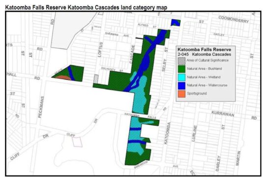
Eight years hence, by the time of Council’s Plans of Management of 2004, prepared by consultancy Environmental Partnership, this area was re-labelled ‘Katoomba Falls Reserve – Cascades section (Selby Street)‘. It had become a disjointed collection of land parcels as the following map shows.
Katoomba Falls Reserve Katoomba Cascades land categorisation map in Upper Kedumba River Valley Plans of Management, revised edition 2004, p. 65
Notably, the following land parcels have been excluded from Katoomba Falls Reserve in Council’s 2004 plan:
The two sports ovals
Most of the bushland south of Cliff Drive
The escarpment top bushland that includes Prince Henry Picnic Area
The area bushland around Katoomba Falls Kiosk, including the kiosk
The area of bushland around what is now Scenic World’s Skyway East Station (sold by the Parks Service to Scenic World in 2006)
The riparian area around Katoomba Cacades and atop Katoomba Falls, including Katoomba Cascades
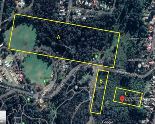
About 4 hectares of intact swamp/bushland including Maple Grove picnic area (Area ‘A’ below)
About a hectare of intact swamp/bushland south along Cliff Drive (Area ‘B’ below)
About a hectare of intact swamp and bushland at the address 14-20 Katoomba Falls Road (Area ‘C’ below)
Edited Google Maps aerial photo, 2022.
Katoomba Falls Reserve
This comprises the southern portion of The Gully Water Catchment and is a mix of Crown Land owned by the NSW Government around the creek to Katoomba Cascades and the top of the Jamison Valley clifftop escarpment at Katoomba Falls.
It includes council owned riparian zone of the creek and surrounding bushland from Neale Street flowing southward, as well as the two sports (cricket) ovals, Katoomba Falls Tourist Park, Maple Grove Park, as well as the side creek riparian zone from Warialda Street and Selby Street, which for years was referred to as Selby Street Reserve.
Selby Street Reserve
This is the above mentioned side creek riparian zone and bushland to the north east direction to Warialda Street and Selby Street. The headwaters of this watercourse begin from a spring originally situated where Hinkler Park lies in a hollow.
The original swamp headwater location of the watercourse in Selby Street Reserve.[Photo by editor August 2022].
Katoomba Golf Course
The Katoomba Golf Course site lies wholly within The Gully Water Catchment situated on the south western portion near the Jamison Escarpment. It covers 30 hectares and the land is owned by Blue Mountains {city} Council, formerly Katoomba Council, and as such it is community land. The Katoomba Golf Club formed in 1911 after the Council approved the native woodland and swamps to be destroyed to make way for fertilised lawn fairways and putting greens.
An historic pursuit by Scottish gentry from 1297AD, Katoomba Golf Course was bulldozed into this creek valley from 1911 as a 9-hole golf course and later bulldozed out to a 18 hole golf course. It went broke in 2013 due to lack of interest in golf, but the ecological damage had been done.
In the 1990s the 9-hole course was expanded to 18 holes by deforesting more adjoining woodland. By 2013 the owner of the club went into liquidation.
At the time of writing, Council has leased the upstairs level of the clubhouse to the Parks Service and is proposing to lease the lower level to a new organisation it terms The Centre for Planetary Health in a joint partnership with two universities. It remains unclear what that organisation will achieve and what the future use of the land will be.
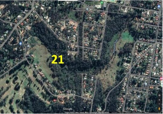
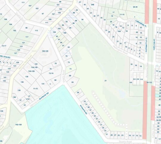
21 Stuarts Road: bushland subdivision for housing
21 Stuarts Road Katoomba is located in the south-west portion of The Gully Water Catchment. It is a single bushland site of covering 12 hectares that is situated between Stuarts and Wellington Roads, west of Burrawang Street in the west of Katoomba. The site comprises remnant bushland, swampland and riparian zone around a watercourse in a easterly-sloped side gully flowing westward confluencing with Kedumba Creek (previously Katoomba Falls Creek) about 200m to the east and downstream.
SOURCE: Google Maps 2022
The following street map identifies ’21’ Stuarts Road in more detail.
Blue Mountains {city} Council records reveal that between 2002 and 2006, the property owner of a rural bushland site, one Ronald Heasman applied for a land use subdivision of the entire site so he could sell off the land for housing development. Heasman’s initial development application to Council proposed a one into 69 lot subdivision [DP 593545, No. 21 STUARTS ROAD, KATOOMBA, FILE NO: (DA) S03/0029]
Essentially, the DA was to bulldoze all the 12 hectares of entire remnant woodland and swampland ecology of the site in order to create and profit from a village-scale dense urbanisation of 69 residential dwellings.
In order to revalue the ecological integrity of this western side gully of The Gully, over time Heasman despatched various bulldozers, excavators, forestry cutters and mulchers and his tractor with a mowing slasher attached to destroy the bushland.
Heasman’s tractor in action on 21 Stuarts Road that The Friends dubbed ‘Hector’. It has been used to steadily deforest this side valley to undermine the ecological integrity. [Photo courtesy of the (former) Friends of Katoomba Falls Creek Valley Inc. taken 2005-01-08].
Relevant planning controls at the time included
Local Environmental Plan 4 (LEP 4) zones the site Residential 2(a1), a zone that permits subdivision and detached dwellings. The minimum allotment size is 700m2 for ordinary allotments and 1,100m2 for hatchet shaped allotments. The minimum frontage is 18.5m.
Local Environmental Plan 1991 (LEP 91) zones the site Environmental Protection. LEP 91 identifies land with a slope in excess of 33% as Protected Area – Environmental Constraints Area.
Local Environmental Plan 2005 (LEP 2005) zones the site Living Bushland conservation and Environmental Protection – General Zone. The LEP designates part of the site Protected Area – Slope Constraint Area, Protected Area – Ecological Buffer Area, and Protected Area – Water Supply Catchment.
The Blue Mountains Better Living Development Control Plan (the Better Living DCP).
At the time, local resident conservation group the Friends of Katoomba Falls Creek Valley Inc. actively campaigned to prevent the ecological destruction of this side valley and against the subdivision for mass housing development application, lobbying Council and arguing as follows:
An over development of the site
The building parameters are unclear.
Significant Alteration of Bushland Character
Fails to comply with ‘Lot Layout’
Fails to comply with ‘Cluster Housing’
Proposal Fails to Provide Adequate Environmental Protection Buffer
Proposal is Contrary to Objectives of LEP 1991
Proposal Is Contrary to the Objectives of ‘Residential A1’ Zoning Under LEP4
Proposal is Contrary to The Objectives of ‘Environmental Protection’ Zoning Under LEP4
Proposal is Contrary to Objectives of ‘Environmental Protection’ Zoning under Draft LEP 2002
Proposal is Contrary to Objectives of ‘Living Bushland Conservation’ Zoning under Draft LEP 2002
Proposal is Contrary to Objectives of ‘Protected Areas’ Zoning under Draft LEP 2002
Likely adverse environmental impact on the ‘Slope Constraint’ Areas
Likely adverse environmental impact on the watercourse
Likely adverse environmental impact upon the water supply catchment.
Likely adverse environmental impact upon the indigenous vegetation and native fauna
Likely Adverse Impact on Biodiversity
Failure to undertake adequate surveys for likely Aboriginal heritage
Failure to assess likely impacts upon Aboriginal Place downstream
Consequential Excessive Demand Upon Katoomba’s Existing Infrastructure, Services and Utilities
Lack of Environmental Impact Statement (EIS)
Failure to provide an assessment of the likely impact on traffic pressures on nearby streetsnersurvey Increased Traffic Congestion to Adjoining and Nearby Streets
The Proposed Creation of Burrawang Street Will Destroy The Existing Bushland Amenity
The Proposal Fails to Identify Likely Impacts to Carlton Street
The Site Location is Too Distant From Town to Justify the provision of ‘Accessible Housing’
The Proposal Fails to Provide Sufficient Details of Dwelling Locations, Design and Landscaping
The Site is Zoned for Environmental Protection
The Subdivision Boundary Will Encroach Upon The Ecological Buffer Area
Destruction of Indigenous Vegetation Communities & Habitat
Downstream Contamination of Kedumba Falls Creek Valley and the Blue Mountains National Park
Absence of a Conservation Management Plan or EIS
Loss of topsoil & contamination by sediment into the watercourse
Steep Slopes Outside Limits for Building Construction
Kedumba Falls Creek Valley holds historical and cultural significance as an aboriginal place.
On 23rd November 2004 [ITEM NO: 7] Blue Mountains {city} Council rightly refused consent for Heasman’s DA outright at its councillors’ ordinary meeting, and pursuant to Section 80 of the Environmental Planning and Assessment Act 1979.
Council formal refusal of Heasman’s massive subdivision was made on the following grounds:
The proposal is contrary to Clause 33 of Local Environmental Plan No. 4 as the proposed battleaxe allotments are below minimum size requirements and there are numerous allotments that do not have minimum frontages required, resulting in an over development of the site.
The proposal is contrary to Clause 42 of Local Environmental Plan No. 4 as the proposal if carried out would not achieve satisfactory arrangements to reduce the risk of bush fire without significantly impacting on the environmental qualities of the site; and due to the impact on the visual amenity of the locality.
The proposal is contrary to the objectives of the Environmental Protection zone within Local Environmental Plan 1991.
The proposal is contrary to Clause 10.5 of Local Environmental Plan 1991 as the proposal if carried out would have an unsatisfactory impact on the native vegetation contained within the site and would have an adverse impact on the water supply catchment and on development excluded land within the site.
The proposal is contrary to the objectives of the Environmental Protection zone, the Living Bushland Conservation zone and the Protected Areas on the site as proposed and mapped under Draft Local Environmental Plan 2002.
The proposal will, if carried out, constitute an over development of the site due to Draft Local Environmental Plan 2002 as the applicant has failed to demonstrate that the proposal will have no adverse environmental impact:
The proposal includes development on the slope constraint areas within Precinct C and Precinct B; and
The proposal will impact on the watercourse that traverses the site and on the buffers that contribute to the protection of that watercourse; and
The proposal will impact on the water supply catchment (Kedumba Creek Catchment) mapped for this locality; and
The proposal will impact on the indigenous vegetation and native fauna present on the site and on significant vegetation communities on the site and downstream of the site; and
The requirements for Asset Protection will have significant impacts on the biodiversity of the site; and
The proposal does not comply with the considerations for lot layout, nor does it comply with the definition of cluster housing.
The development proposal will if carried out, result in significant alteration of the character of the area from a residential bushland character to an urban character.
The applicant has failed to undertake adequate surveys or assessments of the potential of the development to impact on the potential for Aboriginal heritage significance on the site; nor has there been adequate assessment of the potential for the development to impact on the Aboriginal Place located downstream of the subject site.
Insufficient details have been provided in relation to the management of asset protection zones on the site; and landscaping details for individual allotments and across the public areas of the site; and Aboriginal archaeology and cultural significance.
Persistent to get his way, Heasman took Council to the Land and Environment Court of New South Wales (in Sydney) multiple times between 2004 and 2006. He amended his DA proposal thus:
“The applicant proposes to subdivide the land under community title into 46 lots (43 residential lots and 3 community lots) and to erect a dwelling on 42 of the residential lots. The development is divided into three sections: Precincts A, B and C. Lot A8 is a residential lot of 5,032m2, which is proposed for a six-lot subdivision but presented as a single lot because of the uncertainty of access from Burrawang Road. The applicant indicated that when that access becomes available, it intends to lodge a development application reinstating the original six-lot subdivision.” [SOURCE: Heasman v Blue Mountains City Council, 11039 of 2004].
Heasman’s appeal to the Land and Environment Court (LEC) in Sydney used a team of solicitors and barristers who seconded five so-called expert witnesses to support his appeal on technical grounds, being:
Mr M Ball, a town planner retained by the applicant;
Ms N Cavanagh, a town planner employed by the council;
Mr P Mehl, a consulting civil engineer retained by the applicant;
Dr P Bacon, a natural resource scientist retained by the council; and
Mr R Morse, an environmental scientist appointed by the Court,
With support from Council’s appointed experts Ms N Cavanagh and Dr P Bacon, The Land and Environment Court subsequently overruled Councillors’ decision to refuse the application. LEC Senior Commissioner, Dr John Roseth, residing, upheld Heasman’s appeal thus:
“As I indicated above, discussions between the experts led to complete agreement between them. The agreement is reflected in the amended drawings as well as in the conditions of consent. The parties appeared before me on 10 March 2006 stating that there were no outstanding issues and that I should make orders in chambers approving the application.
Orders 1. The appeal is upheld.
2. Development application subdivide the land under community title into 46 lots (43 residential lots and 3 community lots) and to erect a dwelling on 42 of the residential lots on lots 1, 2 and 4 DP 593545, known as 21 Stuarts Road, Katoomba is determined by the granting of consent subject to the conditions in Annexure A.
3. The exhibits are returned except Exhibits 28, A, J, K, L and M.”
The ecological destruction of this side valley incrementally persists to this day, as remnant bushland gets bulldozed and the site is converted to a housing estate and Heasman profits.
Built-Up Subdivided Residential Katoomba
Almost a half of The Gully Water Catchment comprises housing and commercial subdivision across the eastern portion. It includes the commercial high street of Katoomba being Katoomba Street. This water catchment extends from Cascade Street in the north to Ada Street in the east to Lurline Street in the south. North’s Estate housing subdivision extends into the creek valley down a spur westward from the Carrington Hotel on top of the hill. The eastern boundary of the housing subdivision runs north-south along Loftus Street.
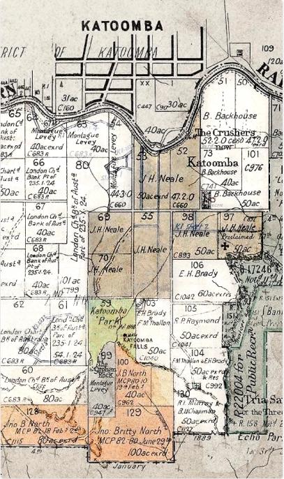
The exact date of Katoomba’s settlement is unclear, but since 1815 it has been on the south side of the Cox’s Road first colonial crossing of the Blue Mountains high plateau bush country. The railway passed by the site of what would become Katoomba from 1967, but the railway platform was not built until 1874. Katoomba was then just a remote rural locality, referred to as The ‘Crushers’ a sandstone quarry for ballast for train descent down plateau eastward. It was situated adjacent to the rail line opposite the site of what is currently The Edge Cinema) as shown in the late 19th Century land title map below.
In 1967, English emigrant pastoralist and later Australian politician, James Henry Neale [1828 – 1890], acquired perhaps the first private permanent houses within The Gully Water Catchment including his ‘Froma House’ situated on the site of the current TAFE college on what is now Parke Street.
As the map reveals, Neale purchased the then swampland of what is referred to as McRae’s Paddock south of what is now Gates Avenue to Katoomba Park. Neale Street on this land is named after Neale. Contrary to standard compass point street planning of the time, Neale Street formed a convenient direct bee-line diagonal access road from his Froma House home to the coal mine that was owned by English emigrant, John Britty North [1831-1917] from 1880. North was a merchant, stockbroker, mining agent and later mining operator of Katoomba Coal and Shale Co. Ltd.
In the 1870s, North had acquired the rest of the plateau bushland and swampland of The Gully Water Catchment and southward into the Jamison Valley, by taking out a mortgage loan with England-based London Chartered Bank of Australia. See his holdings are shown in the map above. The land labelled on the map as Katoomba Park in green was probably retained as Crown land, as it remains so today. North steadily subdivided his land holdings during the 1880s in order to profit from the residential land sales as a means of financing his shale mining business.
The Gully Water Catchment is show by the dotted black outline on the map below. The eastern portion is dominated by the Katoomba township.
‘The Gully Water Catchment’ [SOURCE: Dr Val Attenbrow’s Map of 1993 as ‘The Study Area’, in Katoomba Falls Creek Valley Environmental Study | Draft Report and Management Plan prepared for Blue Mountains [city] Council | by F.&J. Bell & Associates | June 1993 | page 3 of 87].
All rainfall runoff and stormwater from these streets, inside the dotted black line, flows to Katoomba Falls and to the Kedumba River below in the Jamison Valley. This has formed part of the water reservoir behind Warragamba Dam for Sydney’s drinking water supply since it was completed and opened on 14 October 1960.
So what goes down these Katoomba drains ends up in Sydney’s drinking water. As a result, WaterNSW, an agency of the Government of New South Wales, which controls Warragamba Dam water drinking supply adds disinfectants (typically chloramine (chlorine), ammonia and fluoride) to disinfect and purify the water to help make it safe to drink.
A large 3 metre wide stormwater drain at the riparian block at 233A Katoomba Street opposite Hinkler Park at the base of the hill of Katoomba Street. Stormwater runoff from the street and via a large culvert under the street pipe raw stormwater directly into the side creek behind through Selby Street Reserve. [Photo by editor 2022-08-12].
And this is where the stormwater from this drain flows to via a large pipe into the side creek…
‘The Gully – Aboriginal Place’ [Council’s Plan of 2004]
The community lands within this creek valley that had long been gazetted by Council as ‘Frank Walford Park’, ‘Mc Rae’s Paddock’, ‘Selby Street Reserve’ and ‘Katoomba Falls Reserve’ were in 2004 collectively incorporated into Council’s Upper Kedumba River Valley Plans of Management of some 105 pages. This 2004 plan followed a series of previously separate plans for this creek valley that extend back to the 1950s and even back to the days of colonial settler ownership and subdivision of from the 1860s. This 2004 plan was the first to recognise regional Aboriginal historical and pre-historical attachment to this creek valley and was the first plan after this creek valley had been formally declared an ‘Aboriginal Place’, named ‘The Gully – Aboriginal Place’ under the National Parks and Wildlife Act 1974 (NSW).
The rationale and the emergence of legal Aboriginal custodianship of this creek valley came at a brief period in Australia’s socio-political history (pretty much concentrated from Whitlam’s Labor government coming to power in 1972 through to 2002 in respect to this creek valley. The becoming of ‘The Gully- Aboriginal Place‘ is best described in detail particularly 2001-2002 in the documentary book ‘Sacred Waters – The Story of the Blue Mountains Gully Traditional Owners‘ by anthropologist Dianne Johnson [1947-2012] published in 2007. In her superbly researched book, Johnson explains that the critical mover and shaker was local Gundungurra Elder Dawn Colless who in August 2001 had formally nominated the Upper Katoomba Falls Creek Valley (The Gully) for consideration as an Aboriginal Place. Johnson worked closely with Aunty Dawn and members of the Aboriginal community to prepare the submission for state government. This included two related books ‘Aunty Joan Cooper Through the Front Door – a Darug and Gundungurra Story‘ (February 2003) and ‘Report to the Gundungurra Tribal Council concerning Gundungurra Native Title Claim‘ (2004).
On 18th May 2002, the Hon. Bob Debus as NSW member for Blue Mountains and Minister for the Environment, officially declared The Gully “An Aboriginal Place” – a place of special significance to Aboriginal culture.
A concern at the time, was that the declaration had been closed supported by Council and the Parks Service, which had chosen to emphasise the Gundungurra cultural custodianship of this creek valley over and above other cultural claims by Darug, Wonnarua, Wiradjuri, Darkinjung and Tharawal Aboriginal peoples. Council with the Parks Service also behind closed doors and with selective invitees to the declaration process, had deliberately excluded interested local residents, particularly ostracising the Friends of Katoomba Falls Creek Valley (bushcare group), who had since forming in 1989 had continually lobbied Council to end the car racing and to start ecologically rehabilitating this creek valley. The Friends wholly supported respecting Aboriginal cultural claims to The Gully, having over the years learning about their legacy of Aboriginal dispossession. Founder and leader of The Friends, Neil Stuart [1937-2016] initiated a joint community informal partnership between The Friends and former residents of The Gully (aboriginal and non-Aboriginal) and with other caring local residents in 2002, called the informal partnership The Gully Guardians.
But on matters concerning any decisions and management of The Gully – Aboriginal Place, Council has cultural form and policy of refusing to consult with anyone outside their selected few of the Gundungurra. It is an effective socio-political tactic of ‘divide and conquer’ by an organisation hell-bent on process control through ostracising those in the community it does not wish to be accountable to.
As a former member of the Friends, let the truth be told.
Katoomba Falls downstream, politics upstream
The truth about ‘The Gully – Aboriginal Place’ as set aside by Council is that it is only a part of The Gully Water Catchment. Of the remnant bushland within this catchment, ‘The Gully – Aboriginal Place’ comprises selective land portions that are not contiguous, that is, they don’t link up. Yet The Gully historically, before the racetrack land usurpation, which the former residents considered The Gully. It was/is one unified little valley from the northern ridgetop down to Katoomba Falls – two kilometres north to south and one kilometre east to west.
This is what Council bureaucracy has done ‘The Gully – Aboriginal Place‘ portions – divided them up piecemeal. Careful observation of this mapping reveals that many boundaries have changed since Council’s 2004 plan of management.
Upper Kedumba River Valley Plans of Management map, revised edition 2004, page 6.
Gargaree
In around 2005, a small group of former residents of The Gully (from the pre-1957 Council evictions) and their descendants who hold Gundungurra aboriginal ancestral heritage, decided to form an organisation they named The Gully Traditional Owners (GTO). Their purpose has been to become the sole managing custodians of ”The Gully – Aboriginal Place’ in a memorandum of understanding partnership agreement with the legal landholder Blue Mountains {city} Council.
Regrettably, this has proven to be a controlling initiative over what management decisions are made concerning the Gully, about the priority works and their funding and funding streams. Local residents around The Gully and The Gully Valley Catchment, the broader interested local community and former members of The Friends of Katoomba Falls Creek Valley have been deliberately excluded in the consultation process and so effectively ostracised by Council and this group.
If the 1957 forced eviction of The Gully residents for an elitist motor tracing group’s exclusive usage as a racetrack was land usurpation with racist overtones, then how is the current exclusion by The Gully Traditional Owners comprising a select Gundungurra-only membership that excludes interested local residents around The Gully, not the comparable reverse land usurpation…with this time reciprocal racist overtones?
When locals of one race is favoured for planning and decision making about a land area (place) to the deliberate exclusion of a different race of locals, this suggests a racist agenda and so is illegitimate in a national society. This implies a reciprocal repeat of a sad history. As a society here are we learning? Age and experience does not automatically translate to wisdom. It is not a bad thing to grow past your elders in some things.
A few years later GTO decided to rename The Gully (yet again) as ‘Garguree‘. This word apparently means ‘gully’ or ‘valley’ in the Gundungurra language and was sourced from Blue Mountains historian, researcher and author into the Gundungurra history, Jim Smith Ph.D. This follows a contemporary trend of renaming geographic places in Aboriginal language. Is it sending a socially dividing message of some sort of cultural payback to the descendants of non-Aboriginal Australians, who had no say nor played no role in tragic past events in our social history before they were born, just as do the descendants of Aboriginal people and of mixed marriages thereof?
The Gully used to look all like this, pristine riverine ecology uninterrupted by human harm – all the way to Katoomba Falls, Kedumba River, Cox’s River, Nepean River, Hawkesbury River out to Broken Bay on the coast into the Pacific Ocean.
Remnant upland swamp/wetland of The Gully, lately called ‘Gargaree’ [Photo by Editor]
‘The Gully – Aboriginal Place’ [Council’s Plan of 2021]
Blue Mountains {city} Council persists with ongoing re-categorisation of land tenor within The Gully Catchment Area with its ulterior motives that are locally divisive.
Council’s latest 2021 Plan is one of many over the years. But this one is perhaps worse than the others in that as a plan of management it not about rehabilitating this creek valley , but a biased Aboriginal cultural document that has excluded locals to the benefit of a select few. It prescribes a racist agenda of Reverse Land Usurpation.
‘The Gully – Aboriginal Place‘ divided up in Blue Mountains {city} Council’s Plan of Management of 4th October 2021.
While exercising through Katoomba Falls Creek Valley in the Blue Mountains last October, this author came across this sign.
How would one like to see the future of The Gully..for the next 15 years? Have my say? Internet submissions only?
Local government authority Blue Mountains Council in about 2007 renamed this natural valley west of Katoomba ‘The Gully’ because that is the affectionate name it had from the previous residents of mostly regional Aboriginal heritage extending back many thousands of years.
Since 2001, this author has lived 50 metres from the native bushland valley we know as Katoomba Falls Creek Valley, or Sydney Water’s defined Upper Kedumba River, or as Amusement Parlour tourism businessman Horrace Gates’ Catalina Lake, or as Blue Mountains Council’s sponsored car racing enthusiasts (1957-2003) as Catalina Park, or as NSW National Parks call the valley, ‘The Gully’.
Such mixed interpretation of this watercouse valley reflects its history as complex, contested and ongoing culturally problematic. Yet since 1957, here we are in cultural denial in 2019.
In 2002, The Valley was unilaterally declared ‘The Gully’ by Blue Mountains Council – typically again no community consultation.
Ok, so what’s in a name?
‘The Gully – Aboriginal Place’ under the National Parks and Wildlife Act 1974 by the New South Wales government was justified out of recognition of the Valley’s significance holding pre-contact Aboriginal sites, post-contact settlements, its ongoing occupation by Aboriginal People until forced eviction in 1957 (to make way for bulldozing a racetrack), and by lobbying and evidence from local Aboriginal Gundungurra elder, the late Aunty Dawn Colless.
All good. But ‘Aboriginal Place’ only? Says who? By which Blue Mountains heritage Aboriginal people/clan? The Gundungurra Traditional Owners Inc. only and so denying the rights of all other Gully residents and descendants – Aboriginal (eg: Dharug or otherwise) or of non-Aborigines of The Gully?
This is at best Council prejudice and community divide and conquer; at worst Council prejudice against non-Gundungurra, non-Aborigines.
Aboriginal Place declaration while historially valid, was democratically invalid. The NSW Government declaration of such was selective and secret behind Blue Mountains Council’s closed doors – a frequent setting to get things done without pesky outspoken community awareness.
Trust? Blue Mountains Council?
From 1988 to 2016 local residents action group The Friends of Katoomba Falls Creek Valley Inc., under the inspiring and consultative leadership of the late Neil Stuart BSc., had championed a local community cause to save the Valley. From grassroots local resident motives, the Friends aims were from the outset consistently to value and respect the remnant environmental values of the Valley, to lobby to remove the invasive racetrack, to restore the Valley’s ecological integrity throughout and to foster a local community management structure to underpin the Valley’s environmental protection and rehabilition.
Basically The Friends set in train a local community management structure to care for country – the Valley as we called it. But Blue Mountains Council hegemony, situated less than 200 metres east of the Valley, corporate-culturally frustrated and ostracised The Friends out of having any say, participantion or rights in caring for the Valley.
As the awareness of the tragic local Aboriginal past was realised, The Friends respected, engaged and partnered with former residents of The Gully and their descendants (irrespective of racial background). The goal was to properly protect, rehabilitate and manage this acknowledged special place collaboratively. It was a noble mission and undertaking. The activism occupied core Friends members half an adult lifetime, proudly.
Yours truly joined The Friends’ fight to save the valley for just five years from 2002 to 2007 until other commitments took family priority.
The nearly three decades of local resident activism well exceeds the capacity of this article. Suffice to say that the resultant ‘Upper Kedumba River Valley Plans of Management Revised 2004’ achieved not just a desired and just termination to the car racing invasion, but signalled an opportunity and hope for local community partnering with Blue Mountains Council and NSW Parks Service to manage and restore the valley as a valued natural place.
So there is this new signage put up by Blue Mountains Council. After fourteen years, Blue Mountains Council deems The Gully Plan of Management is up for renewal, whatever that means.
Blue Mountains Council claims “This Plan of Management (POM) is fourteen years old and does not reflect the contemporary cultural values and perspectives held by the Gully community.” But what are these?
The local Katoomba community in and around The Gully continues to be shut out of secret talks with the parks service and only select Aborigines – The Gundungurra Traditional Owners Inc. – the legal custodians of most of the valley as appointed by closed shop local council with absolute control over the valley since 2007.
Council entered into an exclusive co-management agreement with The Gully’s traditional owners in 2008, recognising the owners’ deep connection to the place. What about the Dharug? What about other community members who share a deep conservation interest in preserving and rehabilitating the Valley’s ecological values?
Council claims: “Funding from the Office of Environment and Heritage, NSW Heritage Grants – Aboriginal Heritage Projects has been made available to review and up the Plan of Management for the Gully.” But what are these?
“Engagement and consultation with former Gully residents, their descendants and other stakeholders”. Who’s a stakeholder? Blue Mountains Council? The NSW Parks Service? This is not made clear. What about the local community, former members of The Friends of Katoomba Falls Creek Valley Inc. who volunteered years of their lives to save and protect the Gully/Valley from all sorts of harm and development threats?
Council instructs: “The Plan of Management review is being undertaken by Blue Mountains City Council in cooperation with the Gully Traditional Owners Inc.”
Why exclusively this one group of limited Aboriginal representation? Convenience? Simplicity? Becuase the planned outcome has already been decided? What about council consulting with Aboriginal Dharug residents actually born in the Valley/Gully? What about consulting with the immediate local community irrespective of racial background?
Council’s initiated review was made public from about October 2018.
Spell check?
Council instructs that in preparing its revised Plan of Management, its process will include:
Engagement and consultation with former Gully residents, their descendants and other stakeholders
Assessment of relevant information and knowledge to be included in the revised plan
Assessment and determination of current management issues and future opportunities for the Gully
Updating of the management policies and the action plan for the Gully
Prioritisation and costing of actions and works
Except that the entire process is secret. Is it to play into the hands of a few powerful and influential people? Does local council have something to hide from the local community and non-Gundungurra former residents and their decendants until commercial contracts in confidence are signed and its too late to object?
Council instructs: “The existing Plan of Management does not include the Katoomba Falls sports fields or the Tourist Park. The inclusion of these areas into the Gully plan of Management is a significant change from the existing plan.” What is the reason and motive for including more land into the proposed new plan of management?
Council instructs: “The revised Plan will be developed with reference to the Local Government Act 1993, the Crown Lands Management Act 2016, the National Parks and Wildlife Act 1974, and with the Guideline for Developing Management Plans for declared Aboriginal Places. (OEH 2012) The plan also needs to consider the future implications of the Aboriginal Cultural Heritage Bill 2018, which is earmarked to replace functions of the National Parks and Wildlife Act 1974 in relation to the management and protection of Aboriginal places.”
Council acknowledges: ‘The Gully’ was a place where Gundungurra, Darug and other Aboriginal and non-Aboriginal people lived as a fringe community from around the 1890’s onward over a number of generations.”
Council’s References Used:
Local Government Act 1993 (NSW)
Crown Lands Management Act 2016 (NSW)
National Parks and Wildlife Act 1974 (NSW)
Aboriginal Cultural Heritage Bill 2018 (NSW) – earmarked to replace functions of the National Parks and Wildlife Act 1974 in relation to the management and protection of Aboriginal places.
Guidelines for Developing Management Plans for declared Aboriginal Places, NSW Office of Environment and Heritage (2012)
Council has restricted consultative capture of any local community input to some outsourced website based software outfit in Melbourne: Bang The Table’s ‘Have Your Say’: https://www.bluemountainshaveyoursay.com.au/gully-plan Yet Blue Mountains Council’s website now instructs: “Consultation has concluded”.
It’s July 2019 and Blue Mountains Council’s webpage on this process shows the following timeline update:
It would suggest that insufficient resources have been allocated or there are delays in the communications process,or insufficient scheduled time was provided for this project from the outset, or a combination of these.
If local stakeholders missed out on finding out what is going on, should they just await Blue Mountains Council’s press release on its pre-decision making?
Chairperson of the Gully Traditional Owner Inc., Aunty Merle Williams, says: “The Gully is a sacred place to the Aboriginal community who came from the Gully. It was a place for everybody, regardless of who you were or where you came from. It is important that The Gully is managed in a culturally appropriate way using both traditional and contemporary practices.”
The mayor, Mark Greenhill, said council had a strong commitment to working closely with traditional owner groups to care for country. “The revised plan of management for The Gully will guide the future use and management of this significant site over the next 10-15 years.”
Ok so regardless of who you were or where you came from, why are non-members of the Gundungurra Traditional Owners Inc. being excluded from consultation in Blue Mountains Council’s review process?
A brief insight into ‘The Friends of Katoomba Falls Creek Valley Inc.’ and their efforts to protect a special place.
“Gain a short, little known insight into a small group of thoughtful, committed citizens who came together led by the late Neil Stuart to become guardians of a very special natural valley in the Upper Blue Mountains. Learn about the wealth of stories, how over 26 years locals cared for the valley’s integrity, how volunteers committed to half a lifetime of unpaid bushcare, made and sold jam at street stalls to raise funds, and fought a council Goliath. Be shocked by the truth of what really happened in 1957 and the lifetime trauma to what was once an harmonious yet socially marginalised community subsisting on Katoomba’s fringe.
This is of living contemporary social history. This is a controversial expose into one group’s community volunteerism, activism, environmentalism and nimbyism and social justice – thousands of hours given up to save ‘Katoomba Falls Creek Valley’, known by some as ‘The Gully’, known by others as ‘Catalina Raceway’.
This is very much an Australian story, a microcosm of Australian history and pre-history – one locally as rich as it is beautiful yet very sad. It has impacted upon dozens of locals, old families and their ancestors. It is a story about respecting the natural, anthropological and community values of one valley. Recent history became complex, protracted and nasty – involving displacement, forced eviction, invasion, desecration, secret deals, politics, animosities, divide-and-conquer manipulation, empty political promises, conflicting interests, threats and designs by influential millions, the various meetings, many plans of development (some silly), token consultation, one of metaphorically trying to herd cats and twenty six years of community emotional snakes and ladders.
Katoomba Falls
This presentation was delivered by a former member of ‘The Friends’ yesterday at Hobby Reach, Wentworth Falls, the home of the Blue Mountains Historical Society Inc.
For those who attended and requested the reading of the poem…
Ancient Balga, grass tree, xanthorroea in Dwellingup forest, South West Western Australia. Photo by Jenreflect, 20121104.
If we can respectfully wise up and change from calling ‘Ayres Rock’ after an English mining magnate turned politician to ‘Ayers Rock/Uluru’ in 1993, then to ‘Uluru/Ayers Rock’ in 2002, then we can just drop Henry Ayres from the Rock’s association altogether. Henry Ayres was a 19th Century copper mining robber baron who devastated the landscape of Burra in South Australia. A statue in Adelaide near parliament may be appropriate.
Likewise, if we can respectfully wisen up and change from calling this grass tree a ‘black boy’ to calling it a ‘xanthorroea’ then we can call it its traditional name ‘balga’.
“We never catch marron when the creek didn’t run, or the river didn’t run. Always catch marron when the water runs. That’s our culture. You gotta give ’em a chance to breed.
And if you got anything with eggs on ’em, you threw ’em back….We never had nets, yeah, we coulda made nets but we didn’t believe that, you know, you rape the country. So you gotta leave some for the breeding.”
– Partick Hume, 2008, oral history , Kaartdijin Noongar, South West Aboriginal Land and Sea Council, Western Australia.
‘Aboriginal people, not environmentalists, are our best bet for protecting the planet’
<<… Using DNA to track the movement of people in the past, scientists suggest our species evolved some 150,000 years ago on the plains of Africa. That was our habitat, but unlike most other animals, we were creative and used our brains to find ways to exploit our surroundings. We were far less impressive in numbers, size, speed, strength or sensory abilities than many others sharing our territory, but it was our brains that compensated.
Over time, our numbers increased and we moved in search of more and new resources (and probably to check out the Neanderthals with whom we crossbred before they went extinct). When we moved into new territories, we were an alien creature, just like the introduced ones that trouble us today.
George Monbiot of The Guardian makes the point that we can trace the movement of our species by a wave of extinction of the big, slow-moving, dim-witted creatures that we could outwit with even the simplest of implements like clubs, pits, and spears.
Our brains were our great evolutionary advantage, conferring massive memory, curiosity, inventiveness and observational powers.
I can’t emphasize that enough.
Our brains gave us a huge advantage and it did something I think is unique — it created a concept of a future, which meant we realized we could affect that future by our actions in the present. By applying our acquired knowledge and insights, we could deliberately choose a path to avoid danger or trouble, and to exploit opportunities. I believe foresight was a huge evolutionary advantage for our species. And that’s what is so tragic today when we have all the amplified foresight of scientists and supercomputers, which have been warning us for decades that we are heading down a dangerous path, but now we allow politics and economics to override this predictive power.
No doubt after we evolved, we quickly eliminated or reduced the numbers of animals and plants for which we found uses. We had no instinctive behavioural traits to restrict or guide our actions — we learned by the consequences of what we did. And all the mistakes that we made and successes that we celebrated were important lessons in the body of accumulating knowledge of a people in a territory.
That was very powerful and critical to understanding our evolutionary success – it was painstakingly acquired experience that became a part of the culture. We are an invasive species all around the world, and I find it amazing that our brains enabled us to move into vastly different ecosystems ranging from steaming jungles to deserts, mountains to arctic tundra, and to flourish on the basis of the painful accumulation of knowledge through trial and error, mistakes, etc.
So it was the people who stayed in place as others moved on, who had to learn to live within their means, or they died. That is what I believe is the basis of indigenous knowledge that has built up over millennia and that will never be duplicated by science because it is acquired from a profoundly different basis (I wrote about the differences in a book, Wisdom of the Elders). The wave of exploration hundreds of years ago brought a very different world view to new lands — North and South America, Africa, Australia — based on a search for opportunity, resources, wealth. There was no respect for flora and fauna except as potential for riches, and certainly no respect for the indigenous people and their cultures. Of course, by outlawing language and culture of indigenous peoples, dominant colonizers attempt to stamp out the cultures which are such impediments to exploitation of the land. Tom King’s book, The Inconvenient Indian, argues very persuasively that policies are to “get those Indians off the land”.
“There was no respect for flora and fauna except as potential for riches, and certainly no respect for the indigenous people and their cultures.”
I think of my grandparents as part of the wave of exploration of the past centuries. They arrived in Canada from Japan between 1902 and 1904. When they came on a harrowing steamship trip, there were no telephones to Japan, no TV, radio, cellphones or computers. They never learned English. They came on a one-way trip to Canada for the promise of opportunity. Their children, my parents, grew up like all the other Japanese-Canadian kids at that time, with no grandparents and no elders. In other words, they had no roots in Japan or Canada. To them, land was opportunity. Work hard, fish, log, farm, mine, use the land to make money. And I believe that is the dominant ethic today and totally at odds with indigenous perspectives.
Remember when battles were fought over drilling in Hecate Strait, supertankers down the coast from Alaska, the dam at Site C, drilling for oil in ANWR, the dam to be built at Altamire in Brazil?
I was involved in small and big ways in these battles, which we thought we won 30 to 35 years ago. But as you know, they are back on the agenda today. So our victories were illusions because we didn’t change the perspective through which we saw the issues.
“Our victories were illusions because we didn’t change the perspective through which we saw the issues.”
That’s what I say environmentalists have failed to do, to use the battles to get people to change their perspectives, and that’s why I have chosen to work with First Nations because in most cases, they are fighting through the value lenses of their culture.
The challenge is to gain a perspective on our place in nature. That’s why I have made one last push to get a ball rolling on the initiative to enshrine the right to a healthy environment in our constitution. It’s a big goal, but in discussing the very idea, we have to ask, what do we mean by a healthy environment. We immediately come to the realization that the most important factor that every human being needs to live and flourish is a breath of air, a drink of water, food and the energy from photosynthesis. Without those elements, we die.
So our healthy future depends on protecting those fundamental needs, which amazingly enough, are cleansed, replenished and created by the web of life itself. So long as we continue to let the economy and political priorities shape the discussion, we will fail in our efforts to find a sustainable future. I have been trying to tell business folk and politicians that, in the battle over the Northern Gateway, what First Nations are trying to tell us is that their opposition is because there are things more important than money.>>
Things more important than Money
Noongar people are the Aboriginal traditional owners of the south-west of Western Australia and have been for over 45,000 years.
<<Noongar boodja (country) extends from north of Jurien Bay, inland to north of Moora and down to the southern coast between Bremer Bay and east of Esperance. It is defined by 14 different areas with varied geography and 14 dialectal groups.
We have a deep knowledge and respect for our country, which has been passed down by our Elders.
Noongar people have a profound physical and spiritual connection to country. It relates to our beliefs and customs regarding creation, life and death, and spirits of the earth. Spiritual connection to country guides the way we understand, navigate and use the land. It also influences our cultural practices.
For thousands of years Noongar people have resided on and had cultural connection to the booja – land. Everything in our vast landscape has meaning and purpose. We speak our own language and have our own lore and customs. The lore is characterised by a strong spiritual connection to country. This means caring for the natural environment and for places of significance. Our lore relates to ceremonies, and to rituals for hunting and gathering when food is abundant and in season. Connection to booja is passed on through our stories, art, song and dance. Noongar people not only survived European colonisation but we thrived as family groups and sought to assert our rights to our booja. For Noongar people, the south-west of Western Australia is ngulla booja – our country.
Noongar lore and custom guide the ways in which we define our country and our rights to it. Lore influences how we connect with and care for the land. As Noongar people we have a duty to speak for our country, to acknowledge its value to our communities and to observe lore that governs who may or may not ‘speak for country’.
Noongar people have always used our knowledge of the six seasons in the south-west of Western Australia to hunt, fish, and gather only the most ripe and abundant food sources for our needs.
The rituals and ceremonies performed by Noongar people over many thousands of years reflect our sustainable use of the environment and reinforce our connection to country. These rituals include domestic and social customs that observe Noongar lore governing the use of land and resources. An important and significant part of Noongar culture is the teaching of sustainable environmental practices, handed down by our Elders.
Being Noongar is to be part of a family and community, which determines our relationship to country. The relationship to country empowers our identity as a Noongar person.>>
“We come here to this place here, Minningup, the Collie River, to share the story of this area or what makes it so special. It is the resting place of the Ngangungudditj walgu, the hairy faced snake. Baalap ngany noyt is our spirit and this is where he rests. You have big bearded full moon at night time you can see him, his spirit there, his beard resting in the water. And we come to this place here today to show respect to him plus also to meet our people because when they pass away this is where we come to talk to them. Not to the cemetery where they are buried but here because their spirits are in this water. This is where all our spirits will end up here. Karla koorliny we call it. Coming home. Ngany kurt, ngany karla – our heart, our home. This, our Beeliargu, is the river people. So that’s why we always come to this Minningup. It’s very important.
This is the important part of the river, of the whole Collie River and the Preston River and the Brunswick River, because he created all them rivers and all the waters but here is the most important because this is where he rest. So whenever we come back now – my cousin died the other day so we come back here, bring his spirit home because this is where he belong here. They will bury him with his mother and you sing out to him. Ngany moort koorliny. Ngany waanginy, dadjinin waanginy kaartdijin djurip. And we come and look there and talk to you old fellow. Your people have come back. Ngany waangkaniny. I talk now. Balap kaartdijin. Listen, listen. Palanni waangkaniny. Ngany moort koorliny noonook. Ngany moort wanjanin. Your people come to rest with you now. Listen old fellow, listen for ’em, bring them home. Karla koorliny. Bring them home and then you sing to them. (Singing in language) And then chuck sand to land in the water so he can smell you. That’s our rules. Beeliargu moort. That’s the river people. That’s why this place important.”
Me, me, me anthropocentrism is so robber baron babyboomer. Learn about ecocentrism. Caring For Country starts with respect and perhaps respecting that 45,000 years of connection has shown that there are six seasons in Noongar – Birak, Bunuru, Djeran, Makuru, Djilba, Kambarang. (Ed.)
"We're coming to you from the custodial lands of the Hairygowogulator and Tarantulawollygong, and pay respects to uncle and grandaddy elders past, present and emerging from their burrows. So wise to keep a distance out bush."