We have just been notified by IP Australia, the Australian Government’s official registry of intellectual property (that is, governing Australian trademarks, patents and designs, etc. by home grown Australians) that The Habitat Advocate branded logo (image above) has just been legally registered in Australia.
So, we’re pretty happy with this, just quietly. That’s why we’re happily informing the whole Planet! 🙂
A moment of indulgent reflection, if one may…
Well, it’s been a while for us.
Steven John Ridd is the founder of The Habitat Advocate, an environmental conservation advocacy website, championing the cause of the rights of native habitat.
Born in Melbourne, then having travelled on sabbatical, and then having relocated from renting in expensive eastern Sydney’s Randwick out to regional Katoomba in the natural Blue Mountains in 2001, I first registered the business name ‘The Habitat Advocate‘ with the then NSW Department of Fair Trading at Parramatta and the domain habitatadvocate.com.au together back on 10th May 2006. A date close to my heart – my 42nth birthday.
I have used the motto for The Habitat Advocate (A voice for native habitat) publicly since 2001, and the logo (image above) since 2006.
I felt I needed to protect both; this is especially since recently on Google, the use of the word ‘habitat’ and the term ‘habitat advocate’ have become popularised terms used by unrelated others for other purposes. May be they just liked the concept. I did back in 2001 before the trend, because of its genuine natural meaning that was understandable to many, rather than use more highfalutin scientific terms like ‘ecology‘.
So, I commissioned this particular image to be painted by professional wildlife artist, Lyn Naismith, back in 2006 and I invaluably hold her original artwork.
I conceived and designed the logo to be of Australia’s most threatened endemic top order predator in the ecological food chain, the Tigerquoll. I wanted to convey the message of the ongoing threats to native habitat. So, I felt it necessary that the logo image convey reality of being threatened, rearing up on a dead tree branch with nowhere to retreat in its native habitat.
Ecologically, if top order predator communities subsist healthily, then that is a positive signal that the broader localised ecology is healthy as well. That is why we chose the Tigerquoll symbolically.
And we prefer the name Tigerquoll rather than the more lame academic descriptive term of ‘Spotted Tailed Quoll’. That is, we wouldn’t suggest anyone try to pick up and cuddle a Tigerquoll without being ripped to shreds. It’s just like we wouldn’t suggest anyone try to pick up and cuddle an Australian native Brush-tailed Possum with is strong sharp claws and territorialness. Tigerquolls eat Brush-tailed Possums for breakfast, if you know what I mean.
A captured Tigerquoll from Radiata Plateau in 2008. Photo: Courtesy of local identity Glenn Humphreys, who caught it after losing some of his chickens from his rural backyard coop. Glenn handed this caged quoll over to the local National Parks and Wildlife Service of NSW to relocate it into the Blue Mountains National Park nearby.
So, I sincerely thank Lyn for reading my sentiments in this respect exactly, to her credit.
Bureaucratic wheels turn slowly, but now I own the image as a registered logo. This logo is emblematic to promote the habitat threat and our conservation advocacy for native habitat, and this top order predator the Tigerquoll is ecologically apt.
There is one held in captivity in Healesville Sanctuary, but since it is nocturnal, no visitors get to see it in its enclosure by day, and the sanctuary is closed by night. Crazy idea that, and its tiny prison cell-sized enclosure is cruel. They should instead release it into its native habitat and provide visitors with a video presentation to visitors, akin to the Sanctuary’s enclosed darkened platypus auditorium…
It’s about responsible governmental legislative respect for the value of wildlife and proactively decent funding and ecological preservation, restoration and perpetual heritage management of their precious disappearing habitat to sustain their very survival.
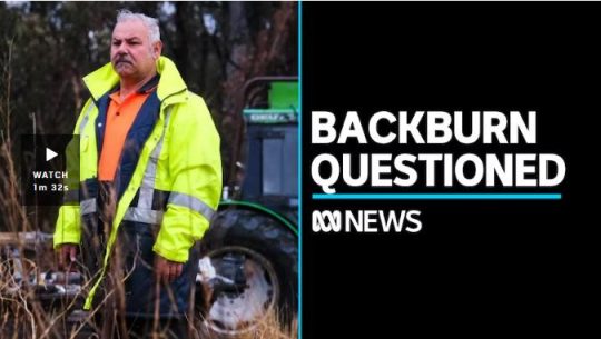
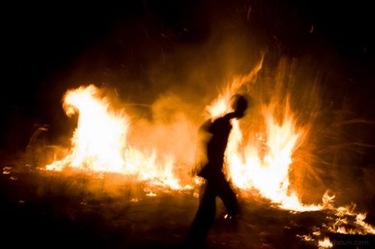
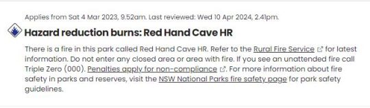
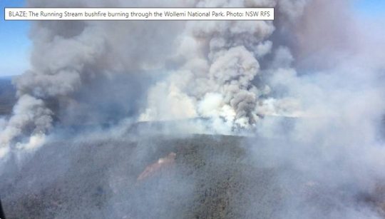
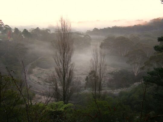
It’s Autumn in the Greater Blue Mountains, and the New South Wales Government’s bush arsonists are out in full swing deliberately setting fire to native habitat at every opportunity. Governmental ‘Habitat Reduction Season‘!
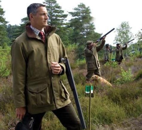
Is this pastime not comparable with the antiquated British imported tradition of the ‘Duck Season‘ – killing NATIVE ducks that is – just for sport. It’s the very same time of year!
“Capital climes for rough shooting old sport, what! Live on peg, we ought to bag a few dozen before tea.”
On Monday 25th March 2024, the NSW Government’s National Parks and Wildlife Service (NPWS) published a media release about its continuing “hazard” reduction burns across the Blue Mountains National Park. It read as follows (main extracts):
“The NSW National Parks and Wildlife Service (NPWS) has announced plans for an 850-hectare hazard reduction burn in the Glenbrook area of Blue Mountains National Park, set to commence on 26 March, weather conditions permitting. This preventive measure is part of a strategic effort to reduce the risk of wildfires and protect surrounding communities.
Scheduled to unfold over consecutive days, the operation targets the reduction of naturally accumulated fuel loads in the park. The primary aim is to provide strategic protection for the residential areas of Glenbrook, Lapstone, and Mulgoa against potential future wildfires.
…This burn is a component of the comprehensive hazard reduction program carried out by NPWS each year, often in collaboration with the Rural Fire Service and Fire and Rescue NSW. These operations are crucial for managing vegetation fuel loads and reducing the intensity and spread of potential wildfires.
The planned hazard reduction burns in Blue Mountains National Park underscore the ongoing commitment of NSW authorities to wildfire risk management and community safety. By taking proactive measures to manage fuel loads, the NPWS aims to mitigate the impact of wildfires, ensuring the protection of both natural landscapes and residential communities.”
Our comments to this bush arson justification spin doctoring:
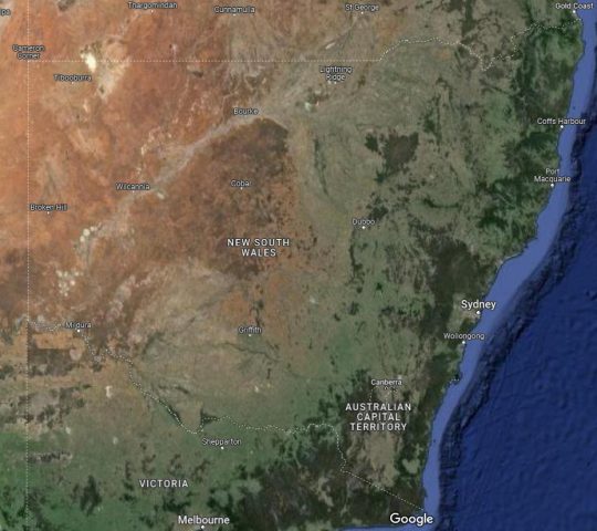
The above is bush arson propaganda by contracted consultants with Communications Degrees, justifying the perpetual decimation of Australia’s native habitat since the first day of colonisation and usurpation of the continent since 1788. Nothing has changed or is likely to. Surviving intact wilderness has become reduced to mere islands. Just go to Google Maps [See our extract map below]
“850 hectares” is an area equivalent to about 30km x 30km (√ 850ha). In relative terms, that’s three times the size of Sydney’s CBD, a native habitat area capacity for many fauna;
“preventive measure is part of a strategic effort to reduce the risk of wildfires” – this is because when wildfires do occur the NSW Government invariably fails to (A) detect, (B) respond and (C) extinguish the ignitions promptly whilst small and controllable. It has an attitude that native habitat has a lower value than human habitat. In contrast, the urban Fire and Rescue Service is tasked to (B) respond and (C) extinguish the ignitions involving human property immediately, and unlike their unpaid volunteer Rural Fire Service (RFS) counterparts, they get paid to do it;
“protect surrounding communities” – this means human communities that have been built encroaching more and more into and usurping native habitat. These human “communities” are the only focus of the NPWS and its support RFS. Under this culture, wildlife communities matter not, irrespective of any threatened species impacted/killed. This attitude belies an antiquated anthropocentric mentality. Neither the NPWS nor the RFS employ an Ecologist. They just don’t care about protecting Ecology – in this case forest ecology;
“the operation targets the reduction of naturally accumulated fuel loads in the park“. That’s right, the NPWS as delegated custodial organisation ‘manager’ of the Blue Mountains National Park treats native habitat and its dependent fauna within such national parks in NSW (one of some 800) instead as “fuel loads” to be reduced to sterile urban park status. NPWS should be relegated to managing urban parks like Hyde Park in Sydney’s CBD;
“The primary aim is to provide strategic protection for the residential areas of Glenbrook, Lapstone, and Mulgoa against potential future wildfires.” – this is a reinforcement approach of our Point 3;
“…This burn is a component of the comprehensive hazard reduction program carried out by NPWS each year, often in collaboration with the Rural Fire Service and Fire and Rescue NSW.” – this is a reinforcement approach of our Point 3;
“These operations are crucial for managing vegetation fuel loads and reducing the intensity and spread of potential wildfires.” – “crucial” for whom? An expanding Sydney human housing sprawl? So the NSW Government’s volunteer and under-resourced RFS has less forested native habitat risk and so less work to do in the event of wildfires because year-on-year there is less forested native habitat left. Perpetuation that long term strategy, there will eventually be little or no native habitat left across NSW. So down the track a future NSW Government may well decide that the RFS is therefore no longer needed and so make the organisation redundant. Sydney that has been deliberately morphed by successive governments (state and federal) into the ‘Greater Sydney Region‘ has, on paper, swallowed whole the ‘Blue Mountains Region‘ (see NSW Planning map below) , presuming its world heritage status is now just outer-upper western Sydney parkland for the rezoning offing. Allowing the 2019 megafires to incinerate 80% of the Greater Blue Mountains World Heritage Area, clearly has achieved the NSW Government’s intended devaluation of the UNESCO recognised “Outstanding Universal Value” of all the Eucalypts, and is wholly consistent with a usurpation agenda for an even Greater Sydney megalopolis.
“The planned hazard reduction burns in Blue Mountains National Park underscore the ongoing commitment of NSW authorities to wildfire risk management and community safety. By taking proactive measures to manage fuel loads, the NPWS aims to mitigate the impact of wildfires, ensuring the protection of both natural landscapes and residential communities.” The spin doctoring clearly by outsourced consultants with Communication Degrees is palpable here. It’s more repetition of contrived persuasive terms: “planned hazard reduction burns”, underscore the “ongoing commitment of NSW authorities to wildfire risk management and community safety”. Ask the residents of Mount Wilson who lost their homes by RFS reckless arson in 2019 on this point! “taking proactive measures to manage fuel loads”, “the NPWS aims to mitigate the impact of wildfires”, “ensuring the protection of both natural landscapes and residential communities.” What so burning the natural landscapes to protect them? Seriously? In truth it is all about avoiding bad publicity when the RFS lights a high risk fire on 14th December 2014 causing homes to be incinerated like at Mount Wilson. “The state coroner has confirmed that a bushfire that destroyed homes in Mt Wilson, Mt Tomah, Berambing and Bilpin in December 2019 was caused after a planned RFS backburn jumped Mt Wilson Road.” [SOURCE: ‘Bushfire inquiry: Mt Wilson backburn to blame‘, BMG, 2nd April 2024]
RFS MOUNT WILSON ARSON: Sam Ramaci, like several of his neighbours, claims a back-burn lit by the RFS on December 14, 2019, was responsible for the destruction of his cool room, tractor and the property that was to fund his retirement. “If they hadn’t started the back-burn, my house would be still standing,” he said. (The NSW Government has refused to compensate him and others (nor even apologise) for the reckless misjudgment of its RFS – a NSW Government agency. Who can afford a class action? [Go to Video Link]
The Mount Wilson fire was the sixth backburn to escape along the southern containment line that was intended to protect the upper Blue Mountains from the Gospers Mountain Fire.
What sane person would join the Rural Fire Starters?
Bush arsonists have a psychological compulsion to set fire to see fire . It’s a ritual – they’re eyes light up. “Behold, The Fiery Cross !...”
NPWS is beholden to NSW Planning
A headline environmental protection agency that is supposed to be caring for national parks reporting to a state land use planning authority (aka Development). Is this a warped governmental portfolio conflict of interest of what? Liberal-Labor-Liberal…? Same Same.
The Regional Map of NSW according to the NSW Government’s Department of Planning and Environment fiefdom in 2024. Note that the Blue Mountains Region no longer exists, but has become annexed by the ever expanding ‘Greater Sydney Region’ in the mindset of Macquarie Street’s urban expansionism campaign. Mount Victoria a Sydney suburb now? Lookout Broken Hill!
Deforestation of Australia since colonisation and its usurpation from 1788. Remnant native forests and their native habitat have been decimated to ecologically unsustainable islands. The entire pre-colonial eastern seaboard of the continent was originally blanketed by native forests unbroken, extending about 600km inland. [SOURCE Google Maps – satellite view, April 2024]
It’s no wonder that Australia continues its record of perpetuating the world’s worst rate of wildlife extinctions. It’s akin to countries like Madagascar. It’s all hell bent on serving the Human Plague Order, currently 8.1 Billion! and in 2024 growing (and demanding more) by $75 million p.a. The current population of Australia is 26,654,200 as of Monday, April 29, 2024. Compare Australia’s Federation census of 1901 counted 3,773,801 people across Australia. [Check: Census Bureau Projects U.S. and World Populations on New Year’s Day; and ^https://www.worldometers.info/world-population/]
But wait there’s more bush arson planned…
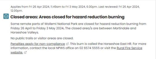
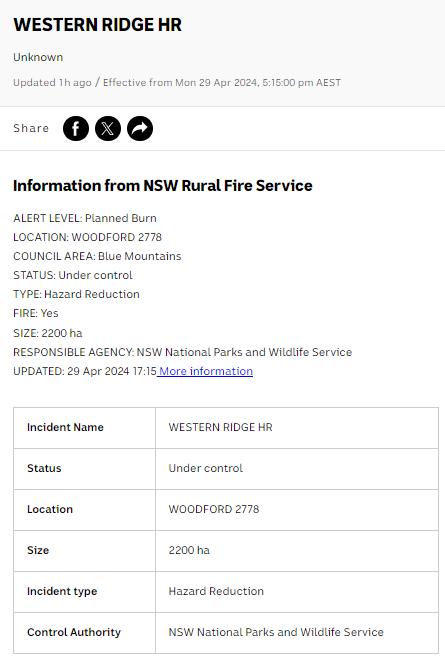
An update last Friday, 26th April 2024 (just days ago), the NSW Government’s environmental department website again posted a media release advising of its further planned “Hazard reduction burn in Blue Mountains National Park” for the weekend.
It read as follows:
“The NSW National Parks and Wildlife Service (NPWS) with assistance from the NSW Rural Fire Service is conducting a hazard reduction burn in Blue Mountains National Park starting Sunday 28 April, weather permitting.
Staff from Metro South West and Blue Mountains regions undertaking the Pisgah Ridge hazard reduction burn near Glenbrook in the Blue Mountains National Park The hazard reduction burn will focus on an area south of Woodford, in the mid-mountains, and cover a total area of about 400 hectares. The burn aims to reduce fuel hazards and assist in the protection of property in the surrounding Woodford, Hazelbrook and Linden areas.
Fire trails around the burn area, including Bedford Creek, will be closed to the public, along with the Murphy’s Glen camping and day use area. The campground will be reopen when it is safe to do so.
Smoke may be seen in the area for up to a week after the initial operation.
The burn is one of many hazard reduction operations undertaken by NPWS each year, many with the assistance of the NSW Rural Fire Service (RFS) and Fire and Rescue NSW.
All burns around the state are coordinated with the NSW RFS to ensure the impact on the community is assessed at a regional level.
People with known health conditions can sign up to receive air quality reports, forecasts and alerts via email or SMS from the Department of Climate Change, Energy, the Environment and Water. For health information relating to smoke from bushfires and hazard reduction burns, visit NSW Health or Asthma Australia.
More information on hazard reduction activities is available at NSW Rural Fire Service and the NSW Government’s Hazards Near Me website and app.”
Asthma sufferers? – NSW Government care factor?
Carbon emissions? – NSW Government care factor?
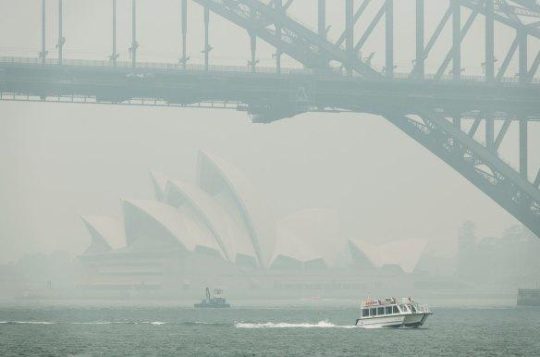
10th December 2019: NPWS world heritage Eucalyptus woodsmoke enveloping Sydney from what started as an abandoned pile burn off Army Road near Gospers Mountain in the distant Wollemi NP two months prior on 26th October 2019. She’ll be right, eh NPWS boss David Crust?
The RFS is one of the planet’s highest emitters of airborne carbon particulates by way of causing mass wood-smoke by repeatedly lighting bushfires and ignoring wildfires. Wood smoke we feel is a tad more polluting than humans exhaling carbon dioxide. But then how many humans on the planet?
Yet the climate change cult remains quiet on this more serious global problem. Why so selective about a lesser pollutant in the hysterical ideology that has morphed from ‘Global Warming‘ (Wallace Smith Broecker’s term of 1975) to ‘The Greenhouse Effect‘ (Mike Hulme’s term in 1994) to ‘Climate Change Scientology‘ (U.S. National Academies of 2014) to currently ‘Climate Crisis‘ actually predating the former (U.S Vice President Al Gore of 2007).
The RFS and NPWS press on regardless – as it’s not carbon dioxide, so all good!
Here’s the latest bush arson schedule to further set fire to the still unburnt native habitat of the Blue Mountains:
RFS:“It’s ok love, it’s good for the bush. She’ll be right.”
It’s an age old mentality of the fox charged to look after the chickens. Both the NPWS and RFS have a cultural attitude that the national parks are NOT to be protected, despite the NPWS delegated to so-called manage NATIONAL parks across New South Wales (NSW). That is despite the Rural Fire Service (RFS) charged with putting out wildfires.
That perverted culture is conditioned to regard native habitat only as a ‘fuel’ that burns and so NOT habitat but a ‘hazard’ to be controlled and burned to prevent it burning. If there is no habitat left, then the meathead rationale, no hazard, so job done! Of recent times the spin doctors in government seconded as contractors with Communications Degrees (aka the art of spin) have softened the community sell of these ‘hazard reductions’ to ‘prescribed burns” to justify and take some noble authority from on high that the BUSH WAS ORDERED TO BE BURNED, WE HAVE NO CHOICE !
All their fire trucks are filled with more flammable liquids light a bushfire than water to put it out. ‘RFS’ should stand for for Rural Fire Starters.
Blue Mountains World Heritage?
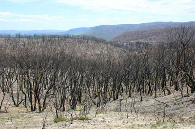
Eventually the bush grows back but with a vastly different flora community make up. The biodiversity is gone. The wildlife don’t come back from the dead.
One of countless Koalas tragically burned to death in her native habitat during the Blue Mountains megafires of 2019. They won’t come back. [This website is not suitable for children to view]
This native Koala would have looked something like this:
National parks throughout Australia over the 236 years since colonisation and its continent-wide deforestation, land use destruction and introduced bushfires, have consistently and hatefully made Australia’s ecological landscape very very quiet and devoid of wildlife.
The 2019 mega bushfires of NSW that the NPWS and RFS let get out of control over months, wiped out 80% of the Greater Blue Mountains World Heritage Area, including rare remnant koala communities and hosts of other at-risk wildlife and their special native habitat that NPWS has no clue of the statistical losses. NPWS does not manage, it mismanages, else just oversees politically drive projects like multi-million dollar tourists track upgrades to benefit humans. The NSW State Government tasked to look after UNESCO world heritage on behalf of the Australia Government?
This habitat reduction regime is to burn the remaining 20% that didn’t cop the 2019 wildfire megablaze. They call this “stewardship”? All trust in the NSW Government to protect world heritage has long gone out the window.
The ‘NPWS’ is a misnomer
‘NPWS” is an abbreviation for the National Parks and Wildlife Service in the state of New South Wales.
Logo of the NPWS
The problem is that this government bureaucracy is supposed to be the governmental (public) custodian for national parks is misleading:
NPWS is not national, rather it is only a NSW governmental sub-department. Governmental ‘management’ of national parks is not national, rather each state and territory has its own national parks, and the Australian Government is not involved – so a bizarre and misleading naming tradition;
NPWS does NOT look after wildlife. Native habitat in these ‘national parks’ is supposed to be protected. Yet every year vast selected areas are burnt deliberately else left to burn on a grand scale, so killing wildlife and destroying their habitat.
As a consequence, the NPWS deserves to be more appropriately renamed as ‘NSW Parks Service‘ just like in Victoria, the Victorian Government calls its equivalent ‘Parks Victoria‘.
On the relevant NSW Government’s website pertaining to its NPWS, it explains that the NPWS is part of a sub-department called ‘Environment and Heritage, which in turn:
“Environment and Heritage is part of the Department of Climate Change, Energy, the Environment and Water.
Our vision is for a thriving, sustainable and resilient New South Wales.Environment and Heritage works with communities, businesses and governments to protect, preserve and strengthen the quality of our natural environment and heritage. We do this through active stewardship that supports a healthy New South Wales.We are committed to creating thriving environments, communities and economies that benefit the people of New South Wales.”
The three most trendy feel-good terms above include: “thriving”, “resilient” , active stewardship”. Pure motherhoodism by the contracted young spin doctors with a Communications Degree. So where are the published wildlife regional extinction stats before and after the Blue Mountains 2019 megablaze?
Recall Tathra Sunday 18 March 2018, the consequence of the RFS deliberately lighting a bushfire on a 38 degree Celsius (100 Fahrenheit) gusty day upwind of this coastal village. [Read Our Article: ‘Bushfire Scenario Was Not Rocket Science‘
[8] ‘Impact of the 2019-20 Mega-Fires on the Greater Blue Mountains World Heritage Area, New South Wales‘, 20221129, by P Smith and J Smith, Issue Vol. 144 (2022), Proceedings of the Linnean Society of New South Wales, ^https://openjournals.library.sydney.edu.au/LIN/article/view/17079
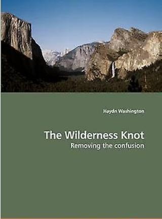
“Over the last thirty years (Ed: 1970s – 2000s] the meaning of the word ‘wilderness‘ has changed and come under sustained attack.
How has the term become so confused? What can be done to reduce this confusion?
This book arose from the Ph.D. thesis ‘The Wilderness Knot’ (University of Western Sydney), and investigates the tangled meanings around ‘wilderness’. This ‘knot‘ is comprised of five strands; philosophical, political, cultural, justice and exploitation. ‘Wilderness‘ as a term is in a unique philosophical position, being disliked by both modernists and many postmodernists alike.
The research uses participatory action research with Aboriginal people and conservationists and wilderness journals. All scholars interviewed agreed that large natural intact areas (‘lanais‘) should be protected, though some did not call them ‘wilderness’.
Confusion declines when one can show that people hold many ideas in common. ‘Mind maps’ are used to investigate the issues and to suggest ways forward to reduce confusion. The idea of shared ‘custodianship’ or stewardship is suggested as a way forward.
This is a book for all those interested in saving and managing the Earth’s remaining large natural areas or wilderness.”
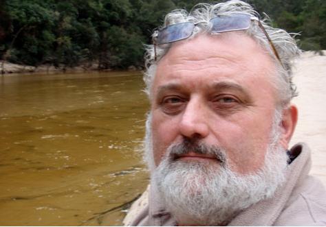
~ Haydn Grinling Washington, Ph.D (2009).
Clicking on our document hyperlink below opens to an internal Adobe PDF document stored on this website, which has been downloaded from the University of Western Sydney’s publicly available website, so it resides in the public domain.
This document is available in the public domain because that was the wishes of its author, the late Australian Environmental Scientist Haydn Grinling Washington – to share and promulgate the environmental philosophy of ‘Ecocentrism‘.
This is the opposite of prevailing ‘Anthropocentrism‘ philosophy. Human beings are NOT the central or most important entity in the universe, despite many arrogantly presuming they deserve to be.
Haydn Grinling Washington [1955-2022]
The document comprises his complete Ph.D thesis submitted in 2006.
Later in 2009, Haydn had his successful thesis published as a book entitled ‘The Wilderness Knot: Removing the confusion‘ in the form of a paperback in A4 size of some 386 pages in length, published by VDM Verlag.
The book version is currently still available to be purchased via reputable Internet resellers for a delivered price for about AUD$180. These currently include FruugoAustralia.com and Amazon.com.
This website’s editor knew Haydn from a number of meeting events (2007-2009) within the Australian conservation movement particular to the Blue Mountains World Heritage Area and discussed his work and philosophies before Haydn’s untimely succumbing to bowel cancer in December 2022.
Haydn wanted to share his environmental passion for respecting the values and wonder of wilderness, native habitat and its wildlife with as many people as possible. He was not about fame and fortune from his many literary works (his prolific poetry and six books).
Our editor was invited and attended Haydn’s funeral service at The Brahma Kumaris meditation retreat centre in Leura in the Blue Mountains in Australia on Thursday 22nd December 2022. We counted about 150 attendees. It was an opportune time to catch up with seasoned conservationists, although we would have wished for a different reason. Haydn had attended this retreat on a number of occasions.
This is his Ph.D thesis in full, available to read and to download:
Haydn Washington dedicated most of his adult life to selected environmental campaigns that affected him in eastern Australia about protecting wilderness areas from human harm, most notably the Wollemi wilderness in the northern part of the Blue Mountains region of New South Wales. Haydn at the time lived nearby, so was this noble planetary Nymyism beyond his backyard?
What is wrong with that? It’s such a selfless cause.
Haydn became the lead campaigner for this vast Wollemi wilderness region of 5,000 km2. He successfully saw it legally protected in 1979 as the Wollemi National Park.
The Wollemi National Park was then in 2000 officially incorporated into the Blue Mountains World Heritage Area, respected as one of eight contiguous national park protected areas along with the Blue Mountains, Yengo, Nattai, Kanangra-Boyd, Gardens of Stone and Thirlmere Lakes National Parks, and the Jenolan Karst Conservation Reserve.
Tragically, two decades later from Saturday 26th October 2019 into January 2020 the custodial authority (NSW National Parks and Wildlife Service of NSW (a misnomer) in cahoots with the New South Wales Rural Fire Service) stood back and allowed a private pile-burn off Army Road near Gospers Mountain inside the Wollomi wilderness get out of control and spread over days, weeks and months.
That single ignition was allowed to blanketly incinerate the pristine Wollemi wilderness in its entirety – all 5,000 km2, endangered Koala communities and all! It was wantonly despicable neglectful act by the Wollemi NP’s and Blue Mountains World Heritage Area’s governmental custodian, NPWS.
Indeed this is why we refer to the NPWS organisation as merely the NSW Parks Service; that’s all it is useful for, just servicing parks, as in urban parks and gardens.
NPWS employs no ecologists, no botanists, no zoologists, no ornithologists, no geologists, and no environmental scientists like Haydn Washington; but only public servants.
This is despite NPWS as a state government agency being delegated with supreme responsibility for the Blue Mountains World Heritage Area and all other national parks within the Australian state of New South Wales and their threatened and endangered ecosystems within.
Indeed defacto bush arson on a calamitous scale never before in Australia’s history by a anthropocentric governmental culture, having a total disregard and contempt toward Wilderness values.
Haydn would have been utterly devastated.
The entire loss of his favoured wilderness by preventable fire would have sapped him of energy and hope. He lived next to it, knew it intimately by exploration on foot and down the length of the dominant wild Colo River by paddle. One presumes the 2019 bushfire disaster of the Wollemi wilderness caused him immense grief and impacted upon his mental health.
Did wiping out the Wollemi trigger Haydn’s heath demise?
We think so. The physical cause of cancer can emerge from psychological stress.
‘Psychological stress‘ describes what individuals experience when they are under mental, physical, or emotional pressure.
‘Stressors‘ are factors that can cause stress such as negative external factors that arise outside one’s control or influence, such as the total loss of one’s life work to protect a wilderness area and its ecology as an environmental scientist with a deep passion for its ecology. Perhaps his psychological stress had become enduring and chronic, causing translating into physical harm.
Research has shown that people who experience chronic stress can have digestive problems, heart disease, high blood pressure, and a weakened immune system. People who experience chronic stress are also more prone to having headaches, sleep trouble, difficulty concentrating, depression, and anxiety and to getting viral infections. The medical science is out (unschooled) on the causation of cancer from chronic psychological stress.
But what is established is that chronic psychological stress can lead to many health problems. A 2019 meta-analysis of nine observational studies in Europe and North America also found an association between work stress and risk of lung, colorectal, and esophageal cancers. Even when stress appears to be linked to cancer risk, the relationship could be indirect. For example, people under chronic stress may develop certain unhealthy behaviours, such as smoking, overeating, becoming less active, or drinking alcohol, that are themselves associated with increased risks of some cancers. The condition may also prevent the body’s immune system from recognizing and fighting cancer cells.
Three years hence in late 2022, Haydn died of cancer, a chronic disease, at aged just 67, before his time. It is in this editor’s view that the government’s apathetic destruction of the precious Wollemi wilderness by bush arson that Haydn loved so dearly, contributed to the premature demise of his health.
NPWS Blue Mountains Branch Director David Crust had the temerity to present himself at Haydn’s funeral, appropriately donned in a full blackened suit and said nothing. The past Commissioner of the NSW Rural Fire Service, Shane Fitzsimmons who was in charge of the NSW 2019 Bushfire emergencies, including the Wollemi bushfire, did not attend.
Vale Haydn, we’re on to your noble legacy. Your passionate championing of native habitat values and your tireless campaigning fights for the preservation of Wilderness will not have been in vane on this website!
Further Reading:
[1] Vale Haydn Grinling Washington Ph.D [1955-2022], >https://habitatadvocate.com.au/vale-haydn-grinling-washington-ph-d-1955-2022/ , (NOTE: This article is a work in progress and so currently remains unavailable to access, however we expect to have it completed and accessible before the end of January 2023.)
We at The Habitat Advocate have lived in Katoomba in the Blue Mountains of Australia since 2001.
Situated on the western fringe of Katoomba, we continue to be closely connected with a small creek valley just below us observed outside our windows, referred to as Katoomba Falls Creek Valley, or by former residents simply as ‘The Gully’.
Katoomba Falls Creek Valley is situated within what we term ‘The Gully Water Catchment’. It is geographically less that 50 metres away from us, uphill on a spur from the Carrington. We observe the amphitheatre-shaped natural valley below and hear it within earshot and we greatly respect where we live and appreciate this area’s complex heritage.
In our mind, the historical and ancestral story of The Gully is a microcosm of the greater story of Australia’s colonial settlement saga. Whilst Australia’s colonial impost saga started from 1788 at Botany Bay then shifted to a fresh water source at Sydney Cove, The Gully’s saga started from 1815 when the Cox’s Road was driven through and then came land acquisition, deforestation, housing subdivision followed by coal mining by robber baron John Britty North who set the wrath from 1883.
The stories of the past of those before us and those current are vital and so to prevent a repeat of history, deserved to be told warts and all out there and everywhere; not greenwashed by mealy-mouthed government bureaucracy after closed door deals, eating canapes at PC publicity events. Raw on-ground truth must hold jurisdiction over political papered propaganda for any decent society.
‘The Gully Water Catchment‘ comprises the upland creek valley catchment of some (290 hectares/2.9 km2) above Katoomba Falls in the Blue Mountains. Over time since the 1870s it has been divided up for various human uses and abuses.
We are connected to this creek valley environmentally and have cared for its ecology and monitored various threats to it for now two decades. As a former member of local resident group activist group the Friends of Katoomba Falls Creek Valley Inc. between 2002-2007 we participated in voluntary Bushcare weeding and rehabilitation and in Streamwatch water quality monitoring.
We are connected politically. We have lobbied the land manager/custodian, Blue Mountains {city} Council since 2001 to secure this creek valley’s ecological protection and rehabilitation).
We are connected socially (we hold a close friendship with many local residents who live around the hilltop fringes surrounding this small creek valley.
We are connected personally (we hear and see the going on down there daily and we walk around it weekly).
We are connected historically having researched those who came before us, some who once lived down in this creek valley. We have researched local history of the area back to 1813).
Essentially, we think we know this small creek valley over the past 21 years quite intimately.
We respect where we live here, regarding this natural creek valley as the environs of our neighourhood; and as an extension of our home environment. To us and to many local residents, this is a beautiful natural creek valley; quiet, peaceful and with a sense of a peaceful welcoming sacred spirit. Our friendship with local elders (some of whom have since passed away) as well as our readings of historical research, confirm this. Since arriving here to call this place home in 2001, our family feels strongly connected to The Gully, like many of our neighbours.
But although we consider The Gully to now be our home after two decades, we are not so family or spiritually connected to The Gully as those who have come before us, who were here long before us but forcibly evicted by authorities. It was simply because they were too poor to protest and fight against powerful and wealthy outsiders who usurped The Gully for their own selfish ends.
The family and spiritual connection to The Gully by those who have come before us, extend back generations. Indeed, their stories and archaeological evidence shows back 14,000 years to this special place. We respect that.
Since various others refer to this creek valley and its many portions by other titles, and given various re-namings by local council over the years, for clarity we herein begin by explaining the various namings and their meanings as follows:
In summary, the portions of land of The Gully Water Catchment, including historically, and their relative sizes are:
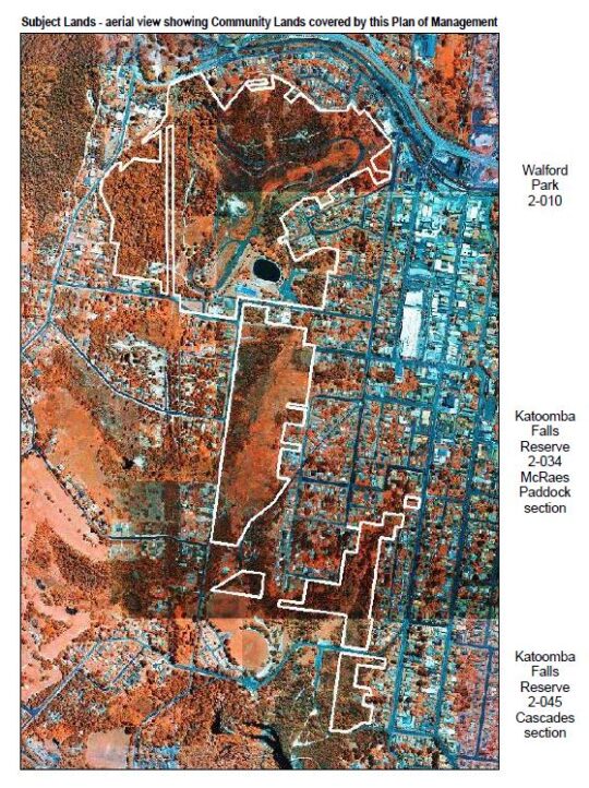
The Gully Water Catchment (290 hectares/2.9 km2)
The Gully (northern section pre-1957) (50 hectares/0.5 km2)
Katoomba Falls Creek Valley (50 hectares/0.5 km2)
Upper Kedumba River Valley (50 hectares/0.5 km2)
McRaes Paddock (17 hectares/0.17 km2)
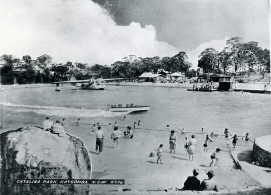
Catalina (amusement) Park (2 hectares/0.2 km2)
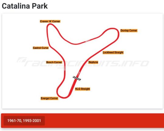
Catalina Park (motor) Raceway (50 hectares/0.5 km2)
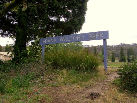
Frank Walford Park (50 hectares/0.5 km2)
Katoomba Park and Katoomba Park Extension (8 hectares/0.8 km2)
Built Up Residential Katoomba (within The Gully Water Catchment) (158 hectares/1.58km2)
21 Stuarts Road (single private land holding – a mixture of pasture and intact sedge swamp (12 hectares/0.12 km2)
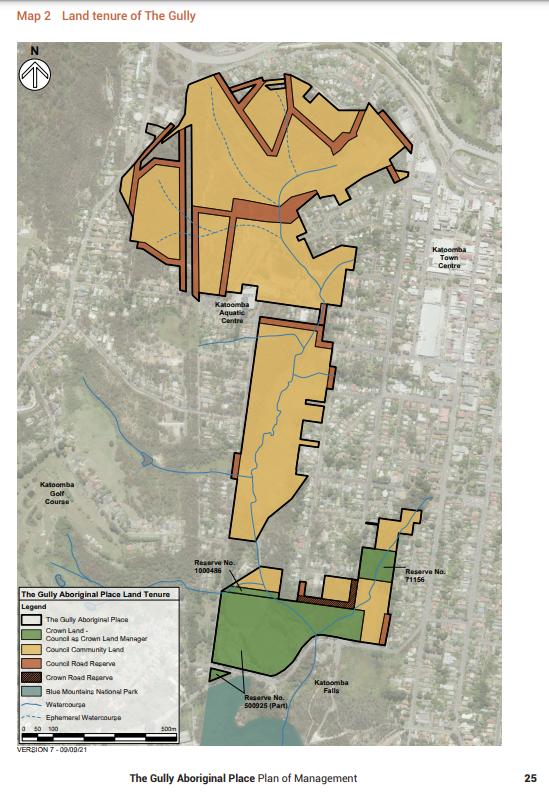
The Gully – Aboriginal Place version 2004 Plan (66 hectares/0.66 km2)
The Gully – Aboriginal Place‘ version 2021 Plan (73 hectares/0.73 km2)
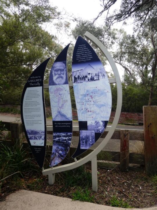
Gargaree‘ (a Gundungurra word for gully) (73 hectares/0.73 km2)
Why so many place-descriptive names for one little sub-catchment? Well, ask Blue Mountains {city} Council, since these place names and their renaming are of Council’s doing.
We notably observe that Council’s land area for ‘The Gully – Aboriginal Place’ in 2021 has expanded from 65.52 hectares since its 2004 Plan to 73 hectares in 2021. Why so? Has a miscalculation/estimate error occurred using different metric methods or software? “65.52 hectares” in its 2004 Plan is pretty darn accurate since down to 0.02 hectares covers an area of just 200m2, or 14m x 14m.
Seriously, is the public who have poor analytical/mathematical interests simply being conned by Council’s guesswork data?
These multiple place names for this creek valley have locally ‘evolved’ over decades to various portions by vested interests. This is confusing to outsiders to comprehend what is what. So from our local knowledge gained from living here for the past 20-odd years and from our passionate interest in researching to better understanding this place, we elaborate.
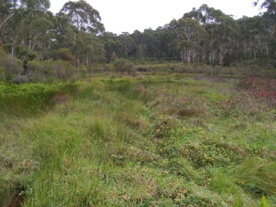
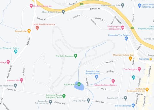
The Gully Water Catchment
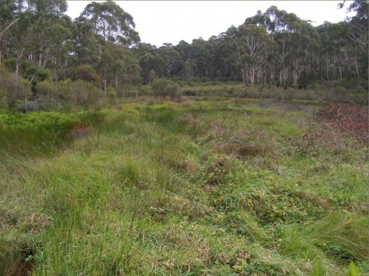
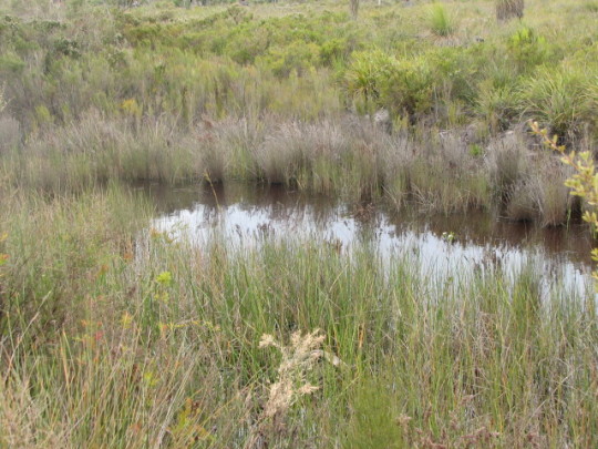
One of the headwaters of Katoomba Falls Creek. One of three StreamWatch water quality testing sites selected by The Friends of Katoomba Falls Creek Valley Bushcare Group [2003-2007]. (Photo by Editor 2011-04-01)
Given the field focus of The Habitat Advocate is ecology, for ecological clarity we shall herein refer to the entire valley catchment area with a hybrid title of ‘The Gully Water Catchment‘. We include the term ‘gully’ as a conciliatory recognition and respect to the former residents who used this term affectionately when they lived here before the racetrack land usurpation* of The Gully.
[Ed: *Usurpation is the act of taking somebody’s position and/or power without having the right to do this. Land Usurpation is the appropriation of land from the previous or lawful owner].
Ecologically, this creek valley is most importantly fundamentally a hydrological environmental system. The natural geography of this creek valley is characterised as an upper course riverscape, which takes the form of a south-facing naturally steep bushland amphitheatre shape in the northern portion of this valley. The valley lies about a thousands metres above sea level.
This area is defined as the entire water catchment area of 290 hectares/2.9 km2. The water catchment’s geographical boundaries comprise the Cox’s Watershed (Bathurst Road) to the north, Valley Road to the Jamison clifftop escarpment to the west, a meandering watershed though central Katoomba to the east and Katoomba Falls to the south.
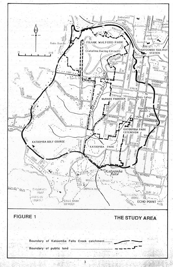
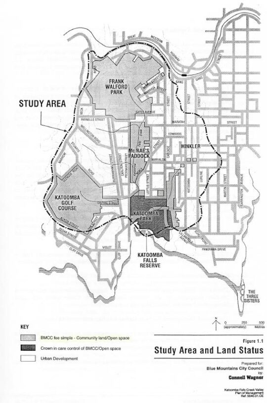
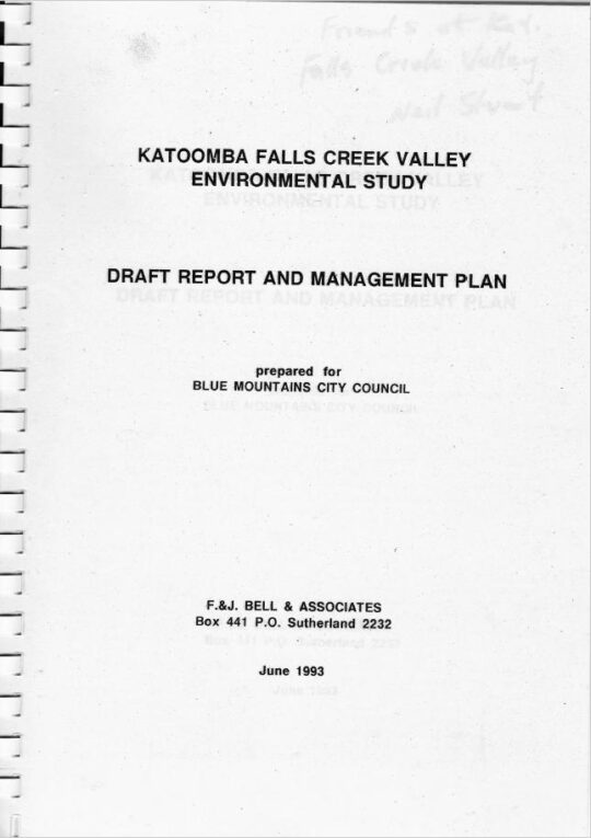
‘The Gully Water Catchment‘ [SOURCE: Dr Val Attenbrow’s Map of 1993 as ‘The Study Area’, in Katoomba Falls Creek Valley Environmental Study | Draft Report and Management Plan prepared for Blue Mountains [city] Council | by F.&J. Bell & Associates | June 1993 | page 3 of 87]
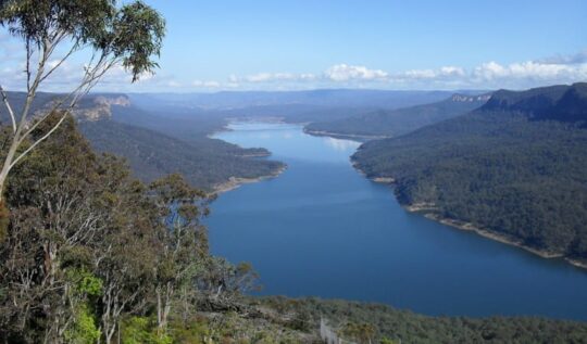
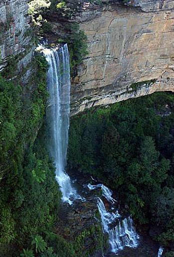
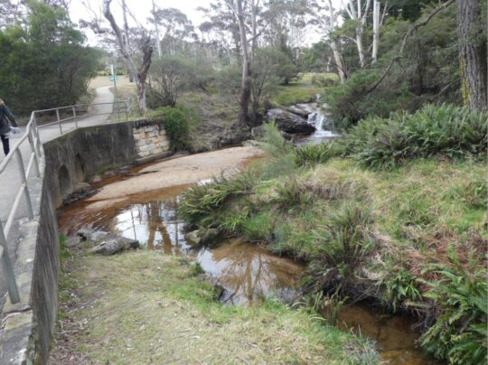
Rainwater that becomes surface water and ground water, flows from a small perennial waterfall and a number of springs which flow into several watercourses that confluence into the central creek with a native sedge swampland riparian zone leading to and surrounding the creek. The creek flows downstream southward over Katoomba Cascades and plunges over Katoomba Falls into the Kedumba River about 300 metres below in the magnificent Jamison Valley of the Blue Mountains World Heritage Area. Kedumba River then flows and meanders southward confluencing into the flooded Cox’s River and the artificial Lake Burragorang (constructed 1948-1960) which has since been Sydney’s primary drinking water supply.
Lake Burragorang (reservoir) is situated about 40km downstream south of The Gully Water Catchment [Photo on Wikipedia by Goran Has taken in January 2014, https://www.flickr.com/photos/goranhas/11897893604/ ]
This all means that indeed the relatively small creek valley on the western fringe of Katoomba forms part of an official drinking water catchment. But it is not just for the benefit of a distant growing urban Greater Sydney metropolis.
The Gully Water Catchment in its own right serves as a vital small natural ecosystem to sustain remnant locally native flora and fauna including aquatic macroinvertebrates throughout its creek riparian zone. This was despite the catchment’s history of land management abuse and neglect by local council and self-interested outsiders.
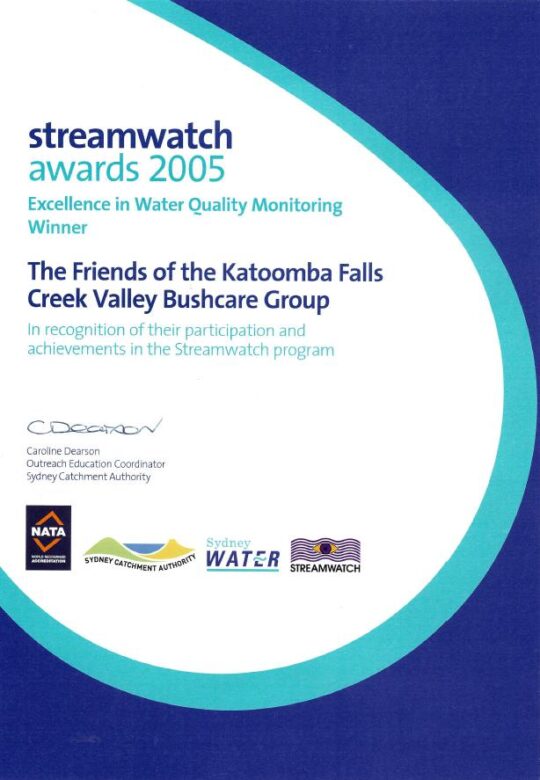
This author for five years between 2003 and 2007, as a former volunteer member of local community group the Friends of Katoomba Falls Creek Valley Bushcare Group (‘The Friends’ for short) undertook regular water quality monitoring and testing of three test sites of this creek under the instruction and resourcing the then Sydney Catchment Authority’s Streamwatch Programme.
‘Citizen science’ indeed!
Our group proudly won five awards over this time for our efforts including this one below in 2005. Our winning award was a recognition by the Sydney Catchment Authority for our specific work in monitoring, testing, investigating and reporting incidents of sewer overflow pollution of the creek from Sydney Water’s sewer network in the valley.
As part of our win, Sydney Catchment Authority rewarded our StreamWatch group with a $2000 cheque thank you.
Fresh flowing water has always been an integral value of this small creek valley. It is not just that it is part of the Kedumba River Water Catchment that supplies drinking water to Sydney, but vital to restoring the local riparian ecology.
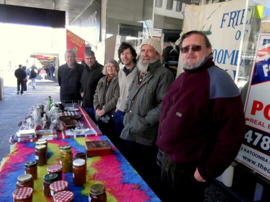
At the time our volunteer charity group The Friends subsequently invested this $2000 into a fixed interest account, since its operational expenses continued to be funded by our street stalls in Katoomba Street. Ultimately, upon the sad passing of the founder and chairperson of The Friends on 26th May 2016, The Friends elected to formally wind up the incorporated organisation. These funds along with the balance of the operational bank account were then gifted to the Blue Mountains Historical Society as part of a successful handover of The Friends archival records spanning 27 years.
Over two centuries, government in NSW (both state and local) continually re-zoned and divided up The Gully Water Catchment from being a pristine natural water catchment into various ‘sold out’ portions, thus.
The New South Wales colonial government’s land usurpation of Aboriginal country west of Sydney for colonial settlement since the British colonial explorers’ crossing of the Blue Mountains in 1813
Government sales of the Blue Mountains plateau lands around what is now Katoomba and Leura (including this creek valley) to various colonial settlers who subsequently deforested the land for timber, cattle and horse grazing and for town building and associated housing subdivision
The acquisition of this creek valley and surrounding land by one John Britty North [1831-1917] in the 1870s for subsequent deforestation, housing subdivision and then for coal mining exploitation to the south
John Britty North’s Katoomba Coal Mine’s coal shale tramway corridor (3 metres wide along the western ridge of the valley since the 1870s from the Jamison Valley escarpment (where Scenic World is located) to a rail loading platform called North’s Siding near the corner of Valley Road and Bathurst Road (next to what locals call ‘Shell Corner’ – where the Shell servicestation used to be situated, currently Bohman Automotive repairs.)
Incremental sales of bushland by Council for housing subdivisions along with urban streets over many years since the 1880s
Catalina Park amusement park and lake [1946-1951]
Council’s subsequent purchase of the land of Catalina Park in 1952
Catalina Park motor racing circuit leased by Council to the Blue Mountains Sporting Drivers Club Ltd [1957-1971]
Council’s aquatic centre constructed in Katoomba Falls Creek valley in the 1980s
Two Council cricket ovals at Katoomba Reserve
Katoomba Golf Course [1911-2013]
Council’s rezoning and subdivision approval of ‘The Escarpments’ townhouses on a portion of the Katoomba Golf Course site (2000 – current)
Council’s caravan park (currently called ‘Katoomba Falls Tourist Park’)
The NSW Government’s Rural Fire Service’s South Katoomba RFB Station with subsequent access roads
The NSW Government’s Rural Fire Service’s Bushfire Control Centre built near the aquatic centre below Mission Street
As a secret waste dump for hundreds of tonnes of sand and rock on top of the swamp extracted from the RTA’s Great Western Highway cutting between Blackheath and Mount Victoria
The areas previously gazetted by Council as Frank Walford Park, Mc Rae’s Paddock, Selby Street Reserve and Katoomba Falls Reserve have in piecemeal been handed over to Gundungurra (Aboriginal)-only custodianship as ‘The Gully – Aboriginal Place’ in 2002
Council’s proposed ‘Centre for Planetary Health’ to occupy the defunct golf course clubhouse from 2022
This list is not complete.
The remnant natural bushland portions of The Gully Water Catchment continue to be steadily sold off periodically by Council (along with many other bushland blocks owned by Council in order it seems to bankroll Council’s annual operations and councillors’ capital works indulgences – external consultants, legal fees, media public relations, over-paid executive management, and unnecessary capital works projects.
The Gully
‘The Gully’ is the old affectionate name given to this creek valley above Katoomba Falls and in particular to the northern portion by its former residents (numbering two or three dozen or so) who lived there for decades from the early 19th Century first contact with British colonial settlers. This was until the last residents were forcibly removed from the gully 1957-1959 by Council and their homes demolished by contracted bulldozer.
“By May 1959, the shacks of the last Gully residents had been all demolished to make way for the Catalina Racing Circuit which officially opened in 1961. “
– John Merriman, Blue Mountains historian.
Aboriginal interpretative sign of 2008 positioned at the entrance to The Gully. It briefly outlines the record of former residents who lived there before the racetrack land usurpation of The Gully.
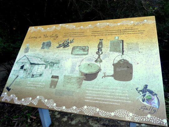
Those residents comprised both locally Aboriginal clan families, comprising predominantly people of Gundungurra and Darug ancestry as well as non-Aboriginal, many of whom had inter-married. It had been a tight-knit self-sufficient yet quite poor community refuge of displaced persons, subsisting in bushland typically in meagre dirt-floor shacks with no utilities (i.e. no connected running water, electricity, gas, plumbing, phonelines or streets).
It had been simple bush living refuge of poor folk subsisting on the fringe of Katoomba of both regional Aboriginal, non-Aboriginal and a intermarried mix of both. Many had been previously displaced in 1948 from their Burragorang Valley bush homes when the NSW government evicted them to flood the valley to create a Sydney’s Warragamba Dam reservoir. The Gully was a close-knit community.
It holds archaeological evidence thanks to field research separately by Dianne Johnson, Ph.D (2001) and Alan Lance (2005) which confirm ancient Aboriginal archaeological sites within the gully extending to ancient origins, extending back as far as 12000 years.
The Gully in the old days (early 1800s to the 1957-59 forced eviction by Blue Mountains {city} Council.
But The Gully people must have had sewage since around 1907 when then Katoomba Municipal Council had trenched up the valley for sewage to flow to the ‘Leura Filter Beds’ via the escarpment around Katoomba Falls and situated down in the Jamison Valley. Remnants of the long disused iron sewer pipe infrastructure may still be seen along on the hiking track between Katoomba Kiosk and the Furber Steps access down into the Jamison Valley.
Before colonial settlement, The Gully had been a traditional ‘summer camp’ location used by regional Aboriginal peoples for meeting and ceremonial place of traditional Aboriginal peoples of the Gundungurra, Darug, Wonnarua, Wiradjuri, Darkinjung and Tharawal of the greater Blue Mountains region and adjoining lands. This was usually is the warmer times of year and this connection to country. Particularly appealing to these traditional people was the constant and reliable supply of fresh flowing spring water and the abundance of bush tacker and wildlife to sustain a small community.
‘The Gully Bringing Back the Sweetwater’, by former residents of The Gully and descendants.
[Source: Blue Mountains {city} Council]
Katoomba Falls Creek Valley
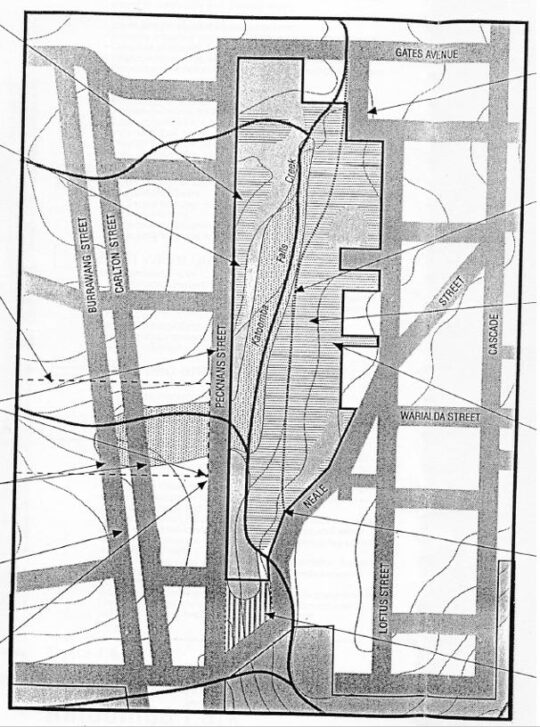
Katoomba Falls Creek Valley was long the gazetted name of this creek valley by local council for decades throughout the 20th Century. The following map shows some identified sub-portions of the creek valley juxtaposed within the black dotted line of the overall water catchment, flowing to Katoomba Falls to the south.
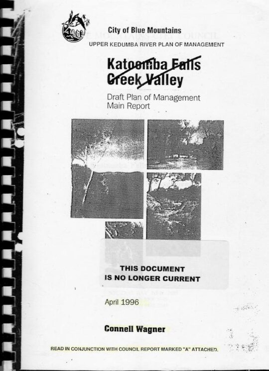
Katoomba Falls Creek Valley – Study Area and Land Status, Draft Plan of Management, (renamed by Council as Upper Kedumba River Plan of Management), by Connell Wagner April 1996.
It was affectionately referred to simply as ‘The Valley’ by surrounding residents’ grassroots environmental group The Friends of Katoomba Falls Creek Valley Inc. (The Friends) which functioned to respect and rehabilitate its natural values and ecology as informal ecological custodians and to challenge the many damaging threats to it by various vested outside interests between the years 1989 and 2016; some 27 years.
Katoomba Falls Creek Valley was the historical name of the full length of this creek valley water catchment up until 1995.
The following recent YouTube video shows the downstream water emanating from this creek valley flowing over Katoomba Cascades and then down Katoomba Falls.
Upper Kedumba River Valley
In 1995 Blue Mountains {city} Council unilaterally decided to rename Katoomba Falls Creek Valley as ‘Upper Kedumba River Valley‘ without local community consultation. One presumes that Council’s renaming logic was because this the central creek flows of this upland valley flows to Katoomba Cascades and over to Katoomba Falls into the Kedumba River more than 300 metres down in the Jamison Valley below, so it seems that some bureaucrat in Council wanted to continue the name to the small creek above the falls.
The renaming suggests Council’s recognition of this upland creek valley as being part of the water catchment area of the Kedumba River below Katoomba Falls and through the lower Jamison Valley. One suspects that given Council’s decades of fighting against the wises of local community environmental activist group The Friends of Katoomba Falls Inc. and that the renaming of the creek valley was a snide attempt by Council to undermine the validity of this group.
Compare the following two documents below. The second shows the original name crossed out by Council.
This study and report by Fred Bell and his environmental consulting team was commissioned by The Friends at a cost of $10,000. It was formerly submitted by The Friends to Council, but was wholly ignored by Council bureaucracy and the councillors at the time. A full transcript copy is made availabe on this website at: https://www.habitatadvocate.com.au/gully-report-1-the-bell-report-of-1993/
This subsequent report was commissioned by Council at ratepayer expense and prepared by Sydney based consulting firm (in Neutral Bay) Connell Wagner and probably at considerably higher cost – not their money.
Council’s 1996 plan of management was pretty much a copy of Fred Bell’s 1993 plan of management for The Friends. Both plans considered the entire water catchment and recommended similar environmental restorative actions be undertaken. It didn’t happen.
As a former member of The Friends, this author recalls that when the group learned of the renaming on Council’s 1996 plan of management title, the group chose not to change their name. Affectionately the members just referred to the entire water catchment simply as ‘The Valley’ for short anyway.
What is so hypocritical of Council’s recognition of this upland creek valley as forming the upper reaches of the water catchment area of the Kedumba River, is that over the decades both state and local government have repeatedly divided up the contiguous water flowing nature of this creek valley in various ways. This includes rezoning various portions of the land from being gazetted as ‘community land’ to being ‘operational land’ so it could be re-purposed and exploited. This dates from the colonial 1870s and continues with Council’s most recent culturally exclusive plan of management of 2021.
Land use development examples include:
James Henry Neale’s subdivision and lobbying from the 1870s to build what has become Katoomba township
John Britty North’s adjoining subdivision and joint lobbying for housing and coal shale mining access from 1883
Various housing subdivision approvals by Council since
Horace Gates Catalina (amusement) Park and dam construction 1946-1951
Council’s sewer network trenching throughout The Gully to facilitate further housing subdivision
Blue Mountains Sporting Drivers’ Motor Racing Club Limited’s motor racing circuit [1957-1971]
Two Council cricket ovals
Council’s aquatic centre – which keeps getting bigger
A bushfire brigade building, hardstand and two access roads
Hundreds of tonnes of sand and rock dumped from a highway development (at Soldiers Pinch) on The Gully’s swampland by the RTA in 2001 (with Council approval)
Sydney Water’s dumping of hundreds of tonnes of sewer fill in The Gully in 2005
Scenic World’s Skyway development in a secret land swap deal between the Parks Service and Council [2006]
Sydney Water’s sewer amplification trenching [2007-2008] to facilitate further housing subdivision
About a hectare of sand and rock fill (1 metre thick) was dumped on top of The Gully swampland by the Roads and Traffic Authority (RTA) in 2001. The RTA has since been rebranded RMS and current TfNSW, probably to avoid its bad reputation.
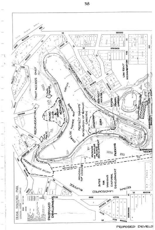
This is just to name a few, and this doesn’t include the many hair-brained proposals for The Gully over the years, like an ice-rink, basketball courts, Scenic World’s cable hang-gliding and flying fox, a complete housing subdivision to be called ‘Highmark’, low-rent accommodation, a museum, and even Katoomba’s own mono-rail! Study Council’s 1981 Plan of Management map below.
The Gully’s legacy of exploitation exemplified in Blue Mountains {city} Council’s 1981 proposed development Plan of (mis)Management, page 38.
The word ‘Kedumba’ is has Aboriginal origins and is just a variation of the word ‘Katoomba’ depending on how it is pronounced. The original meaning was supposedly “tumbling waters” in reference to Katoomba Cascades and Katoomba Falls below.
Katoomba Falls
Another theory espoused by local Blue Mountains historian Jim Smith Ph.D. is that ‘Katoom-ba‘ could have been a local aboriginal Gundungurra phrase relating to the pointing to a certain edible ‘fern: ‘Katoom’ (the fern plant) and ‘ba’ (over there) down in the Jamison Valley. We like the tumbling waters version.
Blue Mountains {city} Council has since renamed Upper Kedumba River as Kedumba River on Google Maps:
Council renamed Katoomba Falls Creek as Kedumba River. Seriously, has Blue Mountains {city} Council bureaucracy got nothing better to do than indulge in ‘cancel culture’ renaming of local geography?
McRae’s Horse Paddock
This middle portion of the creek valley used to be colloquially called by locals as McRae’s Horse Paddock possibly in the post-WWII days of nearby Catalina Park.
This portion comprises the riparian zone and bushland either side of Katoomba Falls Creek extending southward downstream situated south of Gates Avenue in the north, to Neale Street in the south and east of Peckmans Road in the west as the following map shows. It excluse the lands already sold off by Councik for residential housing in the east along Loftus Street.
McRae’s Paddock map, in McRae’s Paddock Action Plan (1996-1999) in Katoomba Falls Creek Valley Draft Plan of Managamnt Main Report, prepared for Blue Mountains {city} Council by Connell Wagner, April 1996. (no page number)
McRaes Paddock (as it has become abbreviated by Council) is characterised as a narrrow riparian swampland corridor midway along the valley creek that extends from being channeled as a drain culvert underneath Gates Avenue and then south for about 800 metres to being similarly channeled as a drain culvert underneath Neale Street.
The creek corridor at this creek valley portion narrows from about 200 metres wide to 100 metres at Neale Street, and the approximate remnant swamp/bushland area not yet been encroached upon by housing, covers about 70 hectares (or 0.7 km2).
Anecdotal local oral history records that the land owner was a grazier by the name of McRae (Scottish heritage spelt ‘Macrae’) who grazed his horses in this ploughed up swampland and the surrounding natural grassland either side of the comparatively narrower section of this creek valley.
Prior to the use of this area as a horse paddock, it had been utilised for market gardening as old photos reveal.
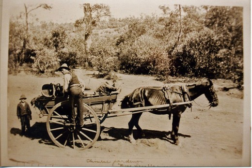
Jimmy War Sing, a Chinese market gardener (circa 1903) of this creek valley area from which the swamp has been ploughed up and soil brought in.
Over the decades post-WWI, Gully locals shortened the name to just ‘McRae’s Paddock’ and the name stuck. The surname has Scottish ancestral origins, the ‘Clan Macrae’ being a traditional Scottish highland clan, however the origins of McRae’s Horse Paddock are not know to us, yet, but give us time with our ongoing research for this website.
Catalina (amusement) Park
Post World War II, between 1946 and 1951 local Katoomba tourism entrepreneurial businessman, Horace Gates, established an amusement park in the valley (The Gully) that, with support from local council aldermen, he named Catalina Park.
However not long after, by 1951 Horace Gates had lost patronage for his amusement attraction and the venue fell into disrepair. In 1952 local council acquired his land in the valley.
Catalina Park Raceway
At this time, Council had hiked up the land rates of properties across the Blue Mountains including those in this creek valley. It was in order to fund Council’s then utility obligations in a growing need for sewage, electricity and road making. Over more than a decade post-war, Council had forcibly acquired many bushland properties that had been investment block of private land holders due to the repeated non-payment of Council’s increasing rate hikes, outsourcing the legalities to the Katoomba legal firm Soper Brothers. By 1957, Council owned most of The Gully.
During the 1950s motorcar racing had become very popular in Australia and particularly with local businessmen in the Upper Blue Mountains who had bought racing cars and wanted to test them out and to compete with one another. Numerous small motorcar garages established and there became a growing motorcar racing fraternity. They registered as as company as the Blue Mountains Sporting Drivers’ Club Limited.
Their short uphill car races became popular, usurping various steep local streets of Katoomba and their power and influence evolved into them lobbying Council for a dedicated local car racing circuit to be established in the Upper Blue Mountains.
The Blue Mountains Councillors obliged on Tuesday 2nd April 1957 by passing the following motions thus:
SOURCE: Council of The [city} of Blue Mountains councillor special meeting minute 447 (c), page 216, dated Tuesday 2nd April 1957.
And then on the same day:
SOURCE: Council of The [city} of Blue Mountains councillor special meeting minute 450, page 216, dated Tuesday 2nd April 1957.
So between 1957 and 1959, Blue Mountains [city] Council proceeded to forcible evict the residents of The Gully and demolish their homes in order to appease these influential businessmen and to construct a motor-racing racetrack circuit in the northern amphitheatre portion of this creek valley. Council funded the racetrack construction by way of a loan to the Blue Mountains Sporting Drivers’ Club Limited, using ratepayer moneys. That loan was never repaid.
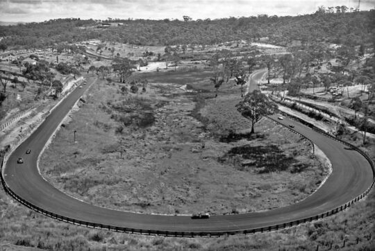
The usurping motor racing fraternity then called the place ‘Catalina Park‘, named after the float plane that had decades earlier been positioned in an artificial dam alongside the creek as an amusement attraction.
This is the name that Blue Mountains {city} Council gave to the northern portion of the creek valley which forms a natural amphitheatre shape and covers about 80 hectares. In the 1990’s, following the demise of Catalina Park racetrack, the government landowner of The Gully, councillors on the Blue Mountains {city} Council unilaterally named this northern portion of the creek valley after one of their own, former alderman Frank Walford [1882-1969] who was also the local mayor on three occasions.
Frank Walford was from Sydney and settled in Katoomba from 1919 just after The Great War where he worked as a journalist with the local newspaper The Blue Mountains Echo and became its editor. He was a keen and experienced bushwalker, bushman, mountaineer a variable adventurer. He became an accomplished author of novels and poetry.
As alderman and mayor he was largely credited (accused by former residents of ‘The Gully’) as being largely responsible for approving the motor racing circuit in 1957 in this portion of the creek valley. However, while he supported the race track construction, Council records show that he was not mayor at the time in 1957, but an alderman.
The park sign off Madge Walford Fountain car park just by Lake Catalina. It was moved likely by Council sometime around 2014. Madge was Frank’s wife. [Photo by Editor 2007-10-27]
Frank Walford Park is bounded by a steep bushland amphitheatre up to the surrounding ridgeline along where Lower Wells Street borders to the north, where Valley Road and Mission Street borders to the west, where Cascade Street borders to the east; and to the south where Gates Avenue, Catalina Avenue and Farnells Road. There is also a spur-line that juts into the valley from the east which includes the residential streets of Murri Street, Waimea Street and Warriga Street.
The surrounding street map around Frank Walford Park. [Google Maps, 2022]
It was the broader gazetted land area of the creek valley around which the 1940s amusement park ‘Catalina Park’ centred around the artificial lake was constructed by Horace Gates and later from 1957 where the 2.1 km ‘Catalina Park’ motor racing circuit was constructed by the former Blue Mountains Sporting Drivers’ Club Limited.
Probably a key justification for Council’s naming of Frank Walford Park after Frank’s passing in 1969 was because his home with his wife Madge was situated close by in an 1880s stone house up on the eastern spur-line overlooking Dunlop Corner at 6 Kundibar Street in Katoomba. Frank and his wife became a fan of the motor racing so much so that during the circuit’s peak operation in the 1960’s Frank had a second storey added to their the stone house as well as a small balcony so they could better watch the car racing especially from the starting grid up Lockheed Straight and left around the sharp Dunlop Corner.
Dunlop Corner of Catalina Park (anti-clockwise) motor racing circuit circa 1965 looking west from up near Katoomba Tyres on Cascade Street. Frank Walford’s family home was located left of the photo, uphill on the spurline above the racetrack. With all the trees cleared by Council, Mayor Walford created an uninterrupted view from his new upstairs balcony. [SOURCE: Blue Mountains Local Studies, ^https://www.flickr.com/photos/blue_mountains_library_-_local_studies/33414945591/]
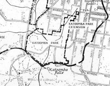
Katoomba Park (and Katoomba Park Extension)
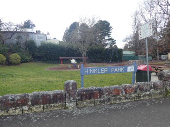
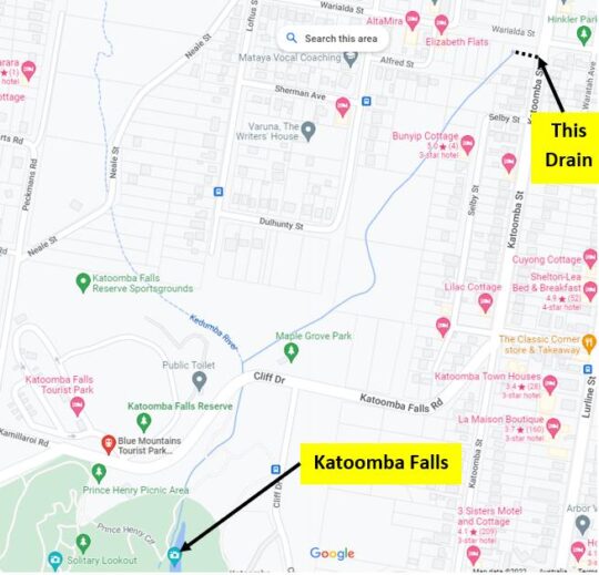
This comprises the southern portion of The Gully Water Catchment between Neale Street and to the Jamison clifftop escarpment around Katoomba Falls. It includes the two sports ovals primarily used for local cricket during the summer months, as well as the caravan park called Katoomba Falls Tourist Park. It also includes the riparian zone along the eastern tributary that has its headwaters at where Hinkler Memorial Park is situated and flows through Selby Street Reserve and alongside Council Maple Grove tourist picnic area. This water course confluences into the main creek just near the road bridge at Cliff Drive.
The confluence of Katoomba Falls Creek (Upper Kedumba River) and the eastern side watercourse (unnamed) which flows through Selby Street Reserve from Hinkler Park. [Photo by editor August 2022].
The names ‘Katoomba Park’ and ‘Katoomba Park Extension’ date from the 1990s and are documented in the Bell Report to Council of 1993 and in the Connell Wagner Plan of Management Report to Council of 1996.
Extract of ‘The Gully Water Catchment’ [SOURCE: Dr Val Attenbrow’s Map of 1993 as ‘The Study Area’, in Katoomba Falls Creek Valley Environmental Study | Draft Report and Management Plan prepared for Blue Mountains [city] Council | by F.&J. Bell & Associates | June 1993 | page 3 of 87]
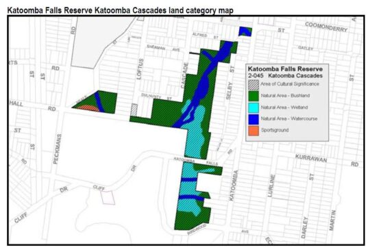
Eight years hence, by the time of Council’s Plans of Management of 2004, prepared by consultancy Environmental Partnership, this area was re-labelled ‘Katoomba Falls Reserve – Cascades section (Selby Street)‘. It had become a disjointed collection of land parcels as the following map shows.
Katoomba Falls Reserve Katoomba Cascades land categorisation map in Upper Kedumba River Valley Plans of Management, revised edition 2004, p. 65
Notably, the following land parcels have been excluded from Katoomba Falls Reserve in Council’s 2004 plan:
The two sports ovals
Most of the bushland south of Cliff Drive
The escarpment top bushland that includes Prince Henry Picnic Area
The area bushland around Katoomba Falls Kiosk, including the kiosk
The area of bushland around what is now Scenic World’s Skyway East Station (sold by the Parks Service to Scenic World in 2006)
The riparian area around Katoomba Cacades and atop Katoomba Falls, including Katoomba Cascades
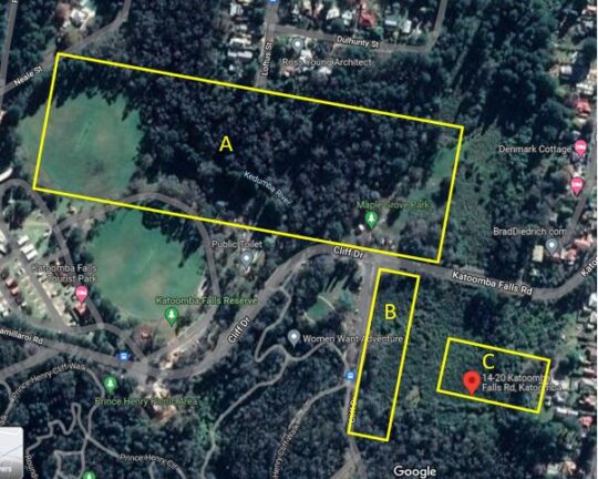
About 4 hectares of intact swamp/bushland including Maple Grove picnic area (Area ‘A’ below)
About a hectare of intact swamp/bushland south along Cliff Drive (Area ‘B’ below)
About a hectare of intact swamp and bushland at the address 14-20 Katoomba Falls Road (Area ‘C’ below)
Edited Google Maps aerial photo, 2022.
Katoomba Falls Reserve
This comprises the southern portion of The Gully Water Catchment and is a mix of Crown Land owned by the NSW Government around the creek to Katoomba Cascades and the top of the Jamison Valley clifftop escarpment at Katoomba Falls.
It includes council owned riparian zone of the creek and surrounding bushland from Neale Street flowing southward, as well as the two sports (cricket) ovals, Katoomba Falls Tourist Park, Maple Grove Park, as well as the side creek riparian zone from Warialda Street and Selby Street, which for years was referred to as Selby Street Reserve.
Selby Street Reserve
This is the above mentioned side creek riparian zone and bushland to the north east direction to Warialda Street and Selby Street. The headwaters of this watercourse begin from a spring originally situated where Hinkler Park lies in a hollow.
The original swamp headwater location of the watercourse in Selby Street Reserve.[Photo by editor August 2022].
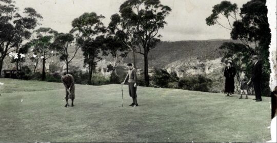
Katoomba Golf Course
The Katoomba Golf Course site lies wholly within The Gully Water Catchment situated on the south western portion near the Jamison Escarpment. It covers 30 hectares and the land is owned by Blue Mountains {city} Council, formerly Katoomba Council, and as such it is community land. The Katoomba Golf Club formed in 1911 after the Council approved the native woodland and swamps to be destroyed to make way for fertilised lawn fairways and putting greens.
An historic pursuit by Scottish gentry from 1297AD, Katoomba Golf Course was bulldozed into this creek valley from 1911 as a 9-hole golf course and later bulldozed out to a 18 hole golf course. It went broke in 2013 due to lack of interest in golf, but the ecological damage had been done.
In the 1990s the 9-hole course was expanded to 18 holes by deforesting more adjoining woodland. By 2013 the owner of the club went into liquidation.
At the time of writing, Council has leased the upstairs level of the clubhouse to the Parks Service and is proposing to lease the lower level to a new organisation it terms The Centre for Planetary Health in a joint partnership with two universities. It remains unclear what that organisation will achieve and what the future use of the land will be.
21 Stuarts Road: bushland subdivision for housing
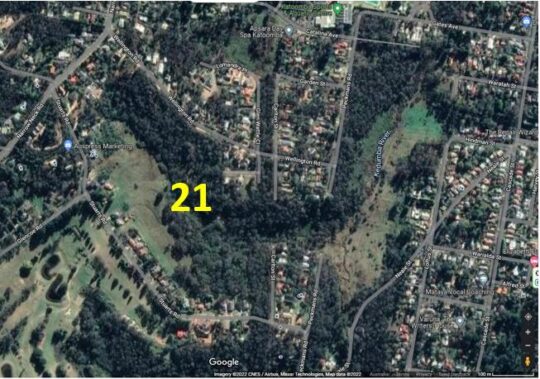
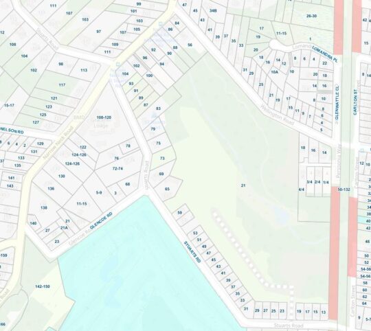
21 Stuarts Road Katoomba is located in the south-west portion of The Gully Water Catchment. It is a single bushland site of covering 12 hectares that is situated between Stuarts and Wellington Roads, west of Burrawang Street in the west of Katoomba. The site comprises remnant bushland, swampland and riparian zone around a watercourse in a easterly-sloped side gully flowing westward confluencing with Kedumba Creek (previously Katoomba Falls Creek) about 200m to the east and downstream.
SOURCE: Google Maps 2022
The following street map identifies ’21’ Stuarts Road in more detail.
Blue Mountains {city} Council records reveal that between 2002 and 2006, the property owner of a rural bushland site, one Ronald Heasman applied for a land use subdivision of the entire site so he could sell off the land for housing development. Heasman’s initial development application to Council proposed a one into 69 lot subdivision [DP 593545, No. 21 STUARTS ROAD, KATOOMBA, FILE NO: (DA) S03/0029]
Essentially, the DA was to bulldoze all the 12 hectares of entire remnant woodland and swampland ecology of the site in order to create and profit from a village-scale dense urbanisation of 69 residential dwellings.
In order to revalue the ecological integrity of this western side gully of The Gully, over time Heasman despatched various bulldozers, excavators, forestry cutters and mulchers and his tractor with a mowing slasher attached to destroy the bushland.
Heasman’s tractor in action on 21 Stuarts Road that The Friends dubbed ‘Hector’. It has been used to steadily deforest this side valley to undermine the ecological integrity. [Photo courtesy of the (former) Friends of Katoomba Falls Creek Valley Inc. taken 2005-01-08].
Relevant planning controls at the time included
Local Environmental Plan 4 (LEP 4) zones the site Residential 2(a1), a zone that permits subdivision and detached dwellings. The minimum allotment size is 700m2 for ordinary allotments and 1,100m2 for hatchet shaped allotments. The minimum frontage is 18.5m.
Local Environmental Plan 1991 (LEP 91) zones the site Environmental Protection. LEP 91 identifies land with a slope in excess of 33% as Protected Area – Environmental Constraints Area.
Local Environmental Plan 2005 (LEP 2005) zones the site Living Bushland conservation and Environmental Protection – General Zone. The LEP designates part of the site Protected Area – Slope Constraint Area, Protected Area – Ecological Buffer Area, and Protected Area – Water Supply Catchment.
The Blue Mountains Better Living Development Control Plan (the Better Living DCP).
At the time, local resident conservation group the Friends of Katoomba Falls Creek Valley Inc. actively campaigned to prevent the ecological destruction of this side valley and against the subdivision for mass housing development application, lobbying Council and arguing as follows:
An over development of the site
The building parameters are unclear.
Significant Alteration of Bushland Character
Fails to comply with ‘Lot Layout’
Fails to comply with ‘Cluster Housing’
Proposal Fails to Provide Adequate Environmental Protection Buffer
Proposal is Contrary to Objectives of LEP 1991
Proposal Is Contrary to the Objectives of ‘Residential A1’ Zoning Under LEP4
Proposal is Contrary to The Objectives of ‘Environmental Protection’ Zoning Under LEP4
Proposal is Contrary to Objectives of ‘Environmental Protection’ Zoning under Draft LEP 2002
Proposal is Contrary to Objectives of ‘Living Bushland Conservation’ Zoning under Draft LEP 2002
Proposal is Contrary to Objectives of ‘Protected Areas’ Zoning under Draft LEP 2002
Likely adverse environmental impact on the ‘Slope Constraint’ Areas
Likely adverse environmental impact on the watercourse
Likely adverse environmental impact upon the water supply catchment.
Likely adverse environmental impact upon the indigenous vegetation and native fauna
Likely Adverse Impact on Biodiversity
Failure to undertake adequate surveys for likely Aboriginal heritage
Failure to assess likely impacts upon Aboriginal Place downstream
Consequential Excessive Demand Upon Katoomba’s Existing Infrastructure, Services and Utilities
Lack of Environmental Impact Statement (EIS)
Failure to provide an assessment of the likely impact on traffic pressures on nearby streetsnersurvey Increased Traffic Congestion to Adjoining and Nearby Streets
The Proposed Creation of Burrawang Street Will Destroy The Existing Bushland Amenity
The Proposal Fails to Identify Likely Impacts to Carlton Street
The Site Location is Too Distant From Town to Justify the provision of ‘Accessible Housing’
The Proposal Fails to Provide Sufficient Details of Dwelling Locations, Design and Landscaping
The Site is Zoned for Environmental Protection
The Subdivision Boundary Will Encroach Upon The Ecological Buffer Area
Destruction of Indigenous Vegetation Communities & Habitat
Downstream Contamination of Kedumba Falls Creek Valley and the Blue Mountains National Park
Absence of a Conservation Management Plan or EIS
Loss of topsoil & contamination by sediment into the watercourse
Steep Slopes Outside Limits for Building Construction
Kedumba Falls Creek Valley holds historical and cultural significance as an aboriginal place.
On 23rd November 2004 [ITEM NO: 7] Blue Mountains {city} Council rightly refused consent for Heasman’s DA outright at its councillors’ ordinary meeting, and pursuant to Section 80 of the Environmental Planning and Assessment Act 1979.
Council formal refusal of Heasman’s massive subdivision was made on the following grounds:
The proposal is contrary to Clause 33 of Local Environmental Plan No. 4 as the proposed battleaxe allotments are below minimum size requirements and there are numerous allotments that do not have minimum frontages required, resulting in an over development of the site.
The proposal is contrary to Clause 42 of Local Environmental Plan No. 4 as the proposal if carried out would not achieve satisfactory arrangements to reduce the risk of bush fire without significantly impacting on the environmental qualities of the site; and due to the impact on the visual amenity of the locality.
The proposal is contrary to the objectives of the Environmental Protection zone within Local Environmental Plan 1991.
The proposal is contrary to Clause 10.5 of Local Environmental Plan 1991 as the proposal if carried out would have an unsatisfactory impact on the native vegetation contained within the site and would have an adverse impact on the water supply catchment and on development excluded land within the site.
The proposal is contrary to the objectives of the Environmental Protection zone, the Living Bushland Conservation zone and the Protected Areas on the site as proposed and mapped under Draft Local Environmental Plan 2002.
The proposal will, if carried out, constitute an over development of the site due to Draft Local Environmental Plan 2002 as the applicant has failed to demonstrate that the proposal will have no adverse environmental impact:
The proposal includes development on the slope constraint areas within Precinct C and Precinct B; and
The proposal will impact on the watercourse that traverses the site and on the buffers that contribute to the protection of that watercourse; and
The proposal will impact on the water supply catchment (Kedumba Creek Catchment) mapped for this locality; and
The proposal will impact on the indigenous vegetation and native fauna present on the site and on significant vegetation communities on the site and downstream of the site; and
The requirements for Asset Protection will have significant impacts on the biodiversity of the site; and
The proposal does not comply with the considerations for lot layout, nor does it comply with the definition of cluster housing.
The development proposal will if carried out, result in significant alteration of the character of the area from a residential bushland character to an urban character.
The applicant has failed to undertake adequate surveys or assessments of the potential of the development to impact on the potential for Aboriginal heritage significance on the site; nor has there been adequate assessment of the potential for the development to impact on the Aboriginal Place located downstream of the subject site.
Insufficient details have been provided in relation to the management of asset protection zones on the site; and landscaping details for individual allotments and across the public areas of the site; and Aboriginal archaeology and cultural significance.
Persistent to get his way, Heasman took Council to the Land and Environment Court of New South Wales (in Sydney) multiple times between 2004 and 2006. He amended his DA proposal thus:
“The applicant proposes to subdivide the land under community title into 46 lots (43 residential lots and 3 community lots) and to erect a dwelling on 42 of the residential lots. The development is divided into three sections: Precincts A, B and C. Lot A8 is a residential lot of 5,032m2, which is proposed for a six-lot subdivision but presented as a single lot because of the uncertainty of access from Burrawang Road. The applicant indicated that when that access becomes available, it intends to lodge a development application reinstating the original six-lot subdivision.” [SOURCE: Heasman v Blue Mountains City Council, 11039 of 2004].
Heasman’s appeal to the Land and Environment Court (LEC) in Sydney used a team of solicitors and barristers who seconded five so-called expert witnesses to support his appeal on technical grounds, being:
Mr M Ball, a town planner retained by the applicant;
Ms N Cavanagh, a town planner employed by the council;
Mr P Mehl, a consulting civil engineer retained by the applicant;
Dr P Bacon, a natural resource scientist retained by the council; and
Mr R Morse, an environmental scientist appointed by the Court,
With support from Council’s appointed experts Ms N Cavanagh and Dr P Bacon, The Land and Environment Court subsequently overruled Councillors’ decision to refuse the application. LEC Senior Commissioner, Dr John Roseth, residing, upheld Heasman’s appeal thus:
“As I indicated above, discussions between the experts led to complete agreement between them. The agreement is reflected in the amended drawings as well as in the conditions of consent. The parties appeared before me on 10 March 2006 stating that there were no outstanding issues and that I should make orders in chambers approving the application.
Orders 1. The appeal is upheld.
2. Development application subdivide the land under community title into 46 lots (43 residential lots and 3 community lots) and to erect a dwelling on 42 of the residential lots on lots 1, 2 and 4 DP 593545, known as 21 Stuarts Road, Katoomba is determined by the granting of consent subject to the conditions in Annexure A.
3. The exhibits are returned except Exhibits 28, A, J, K, L and M.”
The ecological destruction of this side valley incrementally persists to this day, as remnant bushland gets bulldozed and the site is converted to a housing estate and Heasman profits.
Built-Up Subdivided Residential Katoomba
Almost a half of The Gully Water Catchment comprises housing and commercial subdivision across the eastern portion. It includes the commercial high street of Katoomba being Katoomba Street. This water catchment extends from Cascade Street in the north to Ada Street in the east to Lurline Street in the south. North’s Estate housing subdivision extends into the creek valley down a spur westward from the Carrington Hotel on top of the hill. The eastern boundary of the housing subdivision runs north-south along Loftus Street.
The exact date of Katoomba’s settlement is unclear, but since 1815 it has been on the south side of the Cox’s Road first colonial crossing of the Blue Mountains high plateau bush country. The railway passed by the site of what would become Katoomba from 1967, but the railway platform was not built until 1874. Katoomba was then just a remote rural locality, referred to as The ‘Crushers’ a sandstone quarry for ballast for train descent down plateau eastward. It was situated adjacent to the rail line opposite the site of what is currently The Edge Cinema) as shown in the late 19th Century land title map below.
In 1967, English emigrant pastoralist and later Australian politician, James Henry Neale [1828 – 1890], acquired perhaps the first private permanent houses within The Gully Water Catchment including his ‘Froma House’ situated on the site of the current TAFE college on what is now Parke Street.
As the map reveals, Neale purchased the then swampland of what is referred to as McRae’s Paddock south of what is now Gates Avenue to Katoomba Park. Neale Street on this land is named after Neale. Contrary to standard compass point street planning of the time, Neale Street formed a convenient direct bee-line diagonal access road from his Froma House home to the coal mine that was owned by English emigrant, John Britty North [1831-1917] from 1880. North was a merchant, stockbroker, mining agent and later mining operator of Katoomba Coal and Shale Co. Ltd.
In the 1870s, North had acquired the rest of the plateau bushland and swampland of The Gully Water Catchment and southward into the Jamison Valley, by taking out a mortgage loan with England-based London Chartered Bank of Australia. See his holdings are shown in the map above. The land labelled on the map as Katoomba Park in green was probably retained as Crown land, as it remains so today. North steadily subdivided his land holdings during the 1880s in order to profit from the residential land sales as a means of financing his shale mining business.
The Gully Water Catchment is show by the dotted black outline on the map below. The eastern portion is dominated by the Katoomba township.
‘The Gully Water Catchment’ [SOURCE: Dr Val Attenbrow’s Map of 1993 as ‘The Study Area’, in Katoomba Falls Creek Valley Environmental Study | Draft Report and Management Plan prepared for Blue Mountains [city] Council | by F.&J. Bell & Associates | June 1993 | page 3 of 87].
All rainfall runoff and stormwater from these streets, inside the dotted black line, flows to Katoomba Falls and to the Kedumba River below in the Jamison Valley. This has formed part of the water reservoir behind Warragamba Dam for Sydney’s drinking water supply since it was completed and opened on 14 October 1960.
So what goes down these Katoomba drains ends up in Sydney’s drinking water. As a result, WaterNSW, an agency of the Government of New South Wales, which controls Warragamba Dam water drinking supply adds disinfectants (typically chloramine (chlorine), ammonia and fluoride) to disinfect and purify the water to help make it safe to drink.
A large 3 metre wide stormwater drain at the riparian block at 233A Katoomba Street opposite Hinkler Park at the base of the hill of Katoomba Street. Stormwater runoff from the street and via a large culvert under the street pipe raw stormwater directly into the side creek behind through Selby Street Reserve. [Photo by editor 2022-08-12].
And this is where the stormwater from this drain flows to via a large pipe into the side creek…
‘The Gully – Aboriginal Place’ [Council’s Plan of 2004]
The community lands within this creek valley that had long been gazetted by Council as ‘Frank Walford Park’, ‘Mc Rae’s Paddock’, ‘Selby Street Reserve’ and ‘Katoomba Falls Reserve’ were in 2004 collectively incorporated into Council’s Upper Kedumba River Valley Plans of Management of some 105 pages. This 2004 plan followed a series of previously separate plans for this creek valley that extend back to the 1950s and even back to the days of colonial settler ownership and subdivision of from the 1860s. This 2004 plan was the first to recognise regional Aboriginal historical and pre-historical attachment to this creek valley and was the first plan after this creek valley had been formally declared an ‘Aboriginal Place’, named ‘The Gully – Aboriginal Place’ under the National Parks and Wildlife Act 1974 (NSW).
The rationale and the emergence of legal Aboriginal custodianship of this creek valley came at a brief period in Australia’s socio-political history (pretty much concentrated from Whitlam’s Labor government coming to power in 1972 through to 2002 in respect to this creek valley. The becoming of ‘The Gully- Aboriginal Place‘ is best described in detail particularly 2001-2002 in the documentary book ‘Sacred Waters – The Story of the Blue Mountains Gully Traditional Owners‘ by anthropologist Dianne Johnson [1947-2012] published in 2007. In her superbly researched book, Johnson explains that the critical mover and shaker was local Gundungurra Elder Dawn Colless who in August 2001 had formally nominated the Upper Katoomba Falls Creek Valley (The Gully) for consideration as an Aboriginal Place. Johnson worked closely with Aunty Dawn and members of the Aboriginal community to prepare the submission for state government. This included two related books ‘Aunty Joan Cooper Through the Front Door – a Darug and Gundungurra Story‘ (February 2003) and ‘Report to the Gundungurra Tribal Council concerning Gundungurra Native Title Claim‘ (2004).
On 18th May 2002, the Hon. Bob Debus as NSW member for Blue Mountains and Minister for the Environment, officially declared The Gully “An Aboriginal Place” – a place of special significance to Aboriginal culture.
A concern at the time, was that the declaration had been closed supported by Council and the Parks Service, which had chosen to emphasise the Gundungurra cultural custodianship of this creek valley over and above other cultural claims by Darug, Wonnarua, Wiradjuri, Darkinjung and Tharawal Aboriginal peoples. Council with the Parks Service also behind closed doors and with selective invitees to the declaration process, had deliberately excluded interested local residents, particularly ostracising the Friends of Katoomba Falls Creek Valley (bushcare group), who had since forming in 1989 had continually lobbied Council to end the car racing and to start ecologically rehabilitating this creek valley. The Friends wholly supported respecting Aboriginal cultural claims to The Gully, having over the years learning about their legacy of Aboriginal dispossession. Founder and leader of The Friends, Neil Stuart [1937-2016] initiated a joint community informal partnership between The Friends and former residents of The Gully (aboriginal and non-Aboriginal) and with other caring local residents in 2002, called the informal partnership The Gully Guardians.
But on matters concerning any decisions and management of The Gully – Aboriginal Place, Council has cultural form and policy of refusing to consult with anyone outside their selected few of the Gundungurra. It is an effective socio-political tactic of ‘divide and conquer’ by an organisation hell-bent on process control through ostracising those in the community it does not wish to be accountable to.
As a former member of the Friends, let the truth be told.
Katoomba Falls downstream, politics upstream
The truth about ‘The Gully – Aboriginal Place’ as set aside by Council is that it is only a part of The Gully Water Catchment. Of the remnant bushland within this catchment, ‘The Gully – Aboriginal Place’ comprises selective land portions that are not contiguous, that is, they don’t link up. Yet The Gully historically, before the racetrack land usurpation, which the former residents considered The Gully. It was/is one unified little valley from the northern ridgetop down to Katoomba Falls – two kilometres north to south and one kilometre east to west.
This is what Council bureaucracy has done ‘The Gully – Aboriginal Place‘ portions – divided them up piecemeal. Careful observation of this mapping reveals that many boundaries have changed since Council’s 2004 plan of management.
Upper Kedumba River Valley Plans of Management map, revised edition 2004, page 6.
Gargaree
In around 2005, a small group of former residents of The Gully (from the pre-1957 Council evictions) and their descendants who hold Gundungurra aboriginal ancestral heritage, decided to form an organisation they named The Gully Traditional Owners (GTO). Their purpose has been to become the sole managing custodians of ”The Gully – Aboriginal Place’ in a memorandum of understanding partnership agreement with the legal landholder Blue Mountains {city} Council.
Regrettably, this has proven to be a controlling initiative over what management decisions are made concerning the Gully, about the priority works and their funding and funding streams. Local residents around The Gully and The Gully Valley Catchment, the broader interested local community and former members of The Friends of Katoomba Falls Creek Valley have been deliberately excluded in the consultation process and so effectively ostracised by Council and this group.
If the 1957 forced eviction of The Gully residents for an elitist motor tracing group’s exclusive usage as a racetrack was land usurpation with racist overtones, then how is the current exclusion by The Gully Traditional Owners comprising a select Gundungurra-only membership that excludes interested local residents around The Gully, not the comparable reverse land usurpation…with this time reciprocal racist overtones?
When locals of one race is favoured for planning and decision making about a land area (place) to the deliberate exclusion of a different race of locals, this suggests a racist agenda and so is illegitimate in a national society. This implies a reciprocal repeat of a sad history. As a society here are we learning? Age and experience does not automatically translate to wisdom. It is not a bad thing to grow past your elders in some things.
A few years later GTO decided to rename The Gully (yet again) as ‘Garguree‘. This word apparently means ‘gully’ or ‘valley’ in the Gundungurra language and was sourced from Blue Mountains historian, researcher and author into the Gundungurra history, Jim Smith Ph.D. This follows a contemporary trend of renaming geographic places in Aboriginal language. Is it sending a socially dividing message of some sort of cultural payback to the descendants of non-Aboriginal Australians, who had no say nor played no role in tragic past events in our social history before they were born, just as do the descendants of Aboriginal people and of mixed marriages thereof?
The Gully used to look all like this, pristine riverine ecology uninterrupted by human harm – all the way to Katoomba Falls, Kedumba River, Cox’s River, Nepean River, Hawkesbury River out to Broken Bay on the coast into the Pacific Ocean.
Remnant upland swamp/wetland of The Gully, lately called ‘Gargaree’ [Photo by Editor]
‘The Gully – Aboriginal Place’ [Council’s Plan of 2021]
Blue Mountains {city} Council persists with ongoing re-categorisation of land tenor within The Gully Catchment Area with its ulterior motives that are locally divisive.
Council’s latest 2021 Plan is one of many over the years. But this one is perhaps worse than the others in that as a plan of management it not about rehabilitating this creek valley , but a biased Aboriginal cultural document that has excluded locals to the benefit of a select few. It prescribes a racist agenda of Reverse Land Usurpation.
‘The Gully – Aboriginal Place‘ divided up in Blue Mountains {city} Council’s Plan of Management of 4th October 2021.
Although my painting is set in the Styx Valley of the Giants, it transmits childhood memories of ethereal walks amongst the tallest trees found in the Redwood Forests of California. The Mountain Ash trees of Tasmania may arguably have been their contenders, if not for human intervention having commoditised them in their prime. My painting depicts the narrative of these Giants, whose crevassed valleys I have yet to travel.
The relational theme is exemplified through landscapes suspended in space, conveying our universally intricate ties to the natural world; ‘As above so below’. The Giants are fused together by their roots, representing the recently discovered language of trees. Their wiring is juxtaposed with our own ever-escalating dissemination of information.
The native White Bellied Eagle protects his island, which is pockmarked with the scabs of clear felled, old growth forests. The monumental forest transforms from ‘hardy’ to ‘harvested’ and rests amongst machinery within the living limbs of a peace symbol balanced between its adversaries. The aerial perspective above the nest leaves the onus for the forest’s future, inescapably with the viewer.
The ‘Weld Angel’, perched atop a giant tripod, protests peacefully. She embodies repressed respect for mother earth and strives to regain equilibrium with her political nemeses abseiling from what remains of The Valley of the Giants.
Ancient Balga, grass tree, xanthorroea in Dwellingup forest, South West Western Australia. Photo by Jenreflect, 20121104.
If we can respectfully wise up and change from calling ‘Ayres Rock’ after an English mining magnate turned politician to ‘Ayers Rock/Uluru’ in 1993, then to ‘Uluru/Ayers Rock’ in 2002, then we can just drop Henry Ayres from the Rock’s association altogether. Henry Ayres was a 19th Century copper mining robber baron who devastated the landscape of Burra in South Australia. A statue in Adelaide near parliament may be appropriate.
Likewise, if we can respectfully wisen up and change from calling this grass tree a ‘black boy’ to calling it a ‘xanthorroea’ then we can call it its traditional name ‘balga’.
“We never catch marron when the creek didn’t run, or the river didn’t run. Always catch marron when the water runs. That’s our culture. You gotta give ’em a chance to breed.
And if you got anything with eggs on ’em, you threw ’em back….We never had nets, yeah, we coulda made nets but we didn’t believe that, you know, you rape the country. So you gotta leave some for the breeding.”
– Partick Hume, 2008, oral history , Kaartdijin Noongar, South West Aboriginal Land and Sea Council, Western Australia.
‘Aboriginal people, not environmentalists, are our best bet for protecting the planet’
<<… Using DNA to track the movement of people in the past, scientists suggest our species evolved some 150,000 years ago on the plains of Africa. That was our habitat, but unlike most other animals, we were creative and used our brains to find ways to exploit our surroundings. We were far less impressive in numbers, size, speed, strength or sensory abilities than many others sharing our territory, but it was our brains that compensated.
Over time, our numbers increased and we moved in search of more and new resources (and probably to check out the Neanderthals with whom we crossbred before they went extinct). When we moved into new territories, we were an alien creature, just like the introduced ones that trouble us today.
George Monbiot of The Guardian makes the point that we can trace the movement of our species by a wave of extinction of the big, slow-moving, dim-witted creatures that we could outwit with even the simplest of implements like clubs, pits, and spears.
Our brains were our great evolutionary advantage, conferring massive memory, curiosity, inventiveness and observational powers.
I can’t emphasize that enough.
Our brains gave us a huge advantage and it did something I think is unique — it created a concept of a future, which meant we realized we could affect that future by our actions in the present. By applying our acquired knowledge and insights, we could deliberately choose a path to avoid danger or trouble, and to exploit opportunities. I believe foresight was a huge evolutionary advantage for our species. And that’s what is so tragic today when we have all the amplified foresight of scientists and supercomputers, which have been warning us for decades that we are heading down a dangerous path, but now we allow politics and economics to override this predictive power.
No doubt after we evolved, we quickly eliminated or reduced the numbers of animals and plants for which we found uses. We had no instinctive behavioural traits to restrict or guide our actions — we learned by the consequences of what we did. And all the mistakes that we made and successes that we celebrated were important lessons in the body of accumulating knowledge of a people in a territory.
That was very powerful and critical to understanding our evolutionary success – it was painstakingly acquired experience that became a part of the culture. We are an invasive species all around the world, and I find it amazing that our brains enabled us to move into vastly different ecosystems ranging from steaming jungles to deserts, mountains to arctic tundra, and to flourish on the basis of the painful accumulation of knowledge through trial and error, mistakes, etc.
So it was the people who stayed in place as others moved on, who had to learn to live within their means, or they died. That is what I believe is the basis of indigenous knowledge that has built up over millennia and that will never be duplicated by science because it is acquired from a profoundly different basis (I wrote about the differences in a book, Wisdom of the Elders). The wave of exploration hundreds of years ago brought a very different world view to new lands — North and South America, Africa, Australia — based on a search for opportunity, resources, wealth. There was no respect for flora and fauna except as potential for riches, and certainly no respect for the indigenous people and their cultures. Of course, by outlawing language and culture of indigenous peoples, dominant colonizers attempt to stamp out the cultures which are such impediments to exploitation of the land. Tom King’s book, The Inconvenient Indian, argues very persuasively that policies are to “get those Indians off the land”.
“There was no respect for flora and fauna except as potential for riches, and certainly no respect for the indigenous people and their cultures.”
I think of my grandparents as part of the wave of exploration of the past centuries. They arrived in Canada from Japan between 1902 and 1904. When they came on a harrowing steamship trip, there were no telephones to Japan, no TV, radio, cellphones or computers. They never learned English. They came on a one-way trip to Canada for the promise of opportunity. Their children, my parents, grew up like all the other Japanese-Canadian kids at that time, with no grandparents and no elders. In other words, they had no roots in Japan or Canada. To them, land was opportunity. Work hard, fish, log, farm, mine, use the land to make money. And I believe that is the dominant ethic today and totally at odds with indigenous perspectives.
Remember when battles were fought over drilling in Hecate Strait, supertankers down the coast from Alaska, the dam at Site C, drilling for oil in ANWR, the dam to be built at Altamire in Brazil?
I was involved in small and big ways in these battles, which we thought we won 30 to 35 years ago. But as you know, they are back on the agenda today. So our victories were illusions because we didn’t change the perspective through which we saw the issues.
“Our victories were illusions because we didn’t change the perspective through which we saw the issues.”
That’s what I say environmentalists have failed to do, to use the battles to get people to change their perspectives, and that’s why I have chosen to work with First Nations because in most cases, they are fighting through the value lenses of their culture.
The challenge is to gain a perspective on our place in nature. That’s why I have made one last push to get a ball rolling on the initiative to enshrine the right to a healthy environment in our constitution. It’s a big goal, but in discussing the very idea, we have to ask, what do we mean by a healthy environment. We immediately come to the realization that the most important factor that every human being needs to live and flourish is a breath of air, a drink of water, food and the energy from photosynthesis. Without those elements, we die.
So our healthy future depends on protecting those fundamental needs, which amazingly enough, are cleansed, replenished and created by the web of life itself. So long as we continue to let the economy and political priorities shape the discussion, we will fail in our efforts to find a sustainable future. I have been trying to tell business folk and politicians that, in the battle over the Northern Gateway, what First Nations are trying to tell us is that their opposition is because there are things more important than money.>>
Things more important than Money
Noongar people are the Aboriginal traditional owners of the south-west of Western Australia and have been for over 45,000 years.
<<Noongar boodja (country) extends from north of Jurien Bay, inland to north of Moora and down to the southern coast between Bremer Bay and east of Esperance. It is defined by 14 different areas with varied geography and 14 dialectal groups.
We have a deep knowledge and respect for our country, which has been passed down by our Elders.
Noongar people have a profound physical and spiritual connection to country. It relates to our beliefs and customs regarding creation, life and death, and spirits of the earth. Spiritual connection to country guides the way we understand, navigate and use the land. It also influences our cultural practices.
For thousands of years Noongar people have resided on and had cultural connection to the booja – land. Everything in our vast landscape has meaning and purpose. We speak our own language and have our own lore and customs. The lore is characterised by a strong spiritual connection to country. This means caring for the natural environment and for places of significance. Our lore relates to ceremonies, and to rituals for hunting and gathering when food is abundant and in season. Connection to booja is passed on through our stories, art, song and dance. Noongar people not only survived European colonisation but we thrived as family groups and sought to assert our rights to our booja. For Noongar people, the south-west of Western Australia is ngulla booja – our country.
Noongar lore and custom guide the ways in which we define our country and our rights to it. Lore influences how we connect with and care for the land. As Noongar people we have a duty to speak for our country, to acknowledge its value to our communities and to observe lore that governs who may or may not ‘speak for country’.
Noongar people have always used our knowledge of the six seasons in the south-west of Western Australia to hunt, fish, and gather only the most ripe and abundant food sources for our needs.
The rituals and ceremonies performed by Noongar people over many thousands of years reflect our sustainable use of the environment and reinforce our connection to country. These rituals include domestic and social customs that observe Noongar lore governing the use of land and resources. An important and significant part of Noongar culture is the teaching of sustainable environmental practices, handed down by our Elders.
Being Noongar is to be part of a family and community, which determines our relationship to country. The relationship to country empowers our identity as a Noongar person.>>
“We come here to this place here, Minningup, the Collie River, to share the story of this area or what makes it so special. It is the resting place of the Ngangungudditj walgu, the hairy faced snake. Baalap ngany noyt is our spirit and this is where he rests. You have big bearded full moon at night time you can see him, his spirit there, his beard resting in the water. And we come to this place here today to show respect to him plus also to meet our people because when they pass away this is where we come to talk to them. Not to the cemetery where they are buried but here because their spirits are in this water. This is where all our spirits will end up here. Karla koorliny we call it. Coming home. Ngany kurt, ngany karla – our heart, our home. This, our Beeliargu, is the river people. So that’s why we always come to this Minningup. It’s very important.
This is the important part of the river, of the whole Collie River and the Preston River and the Brunswick River, because he created all them rivers and all the waters but here is the most important because this is where he rest. So whenever we come back now – my cousin died the other day so we come back here, bring his spirit home because this is where he belong here. They will bury him with his mother and you sing out to him. Ngany moort koorliny. Ngany waanginy, dadjinin waanginy kaartdijin djurip. And we come and look there and talk to you old fellow. Your people have come back. Ngany waangkaniny. I talk now. Balap kaartdijin. Listen, listen. Palanni waangkaniny. Ngany moort koorliny noonook. Ngany moort wanjanin. Your people come to rest with you now. Listen old fellow, listen for ’em, bring them home. Karla koorliny. Bring them home and then you sing to them. (Singing in language) And then chuck sand to land in the water so he can smell you. That’s our rules. Beeliargu moort. That’s the river people. That’s why this place important.”
Me, me, me anthropocentrism is so robber baron babyboomer. Learn about ecocentrism. Caring For Country starts with respect and perhaps respecting that 45,000 years of connection has shown that there are six seasons in Noongar – Birak, Bunuru, Djeran, Makuru, Djilba, Kambarang. (Ed.)
Wildlife photography is not about humanising wildlife for entertainment. It ought to be about awareness, wonder and respect for wildlife and their habitat.
Zoology may be about technical understanding of the structure and classification of the animal kingdom, but since Darwin we have realised that animals are so much more complex creatures of behaviour and integral to ecology than just being taxidermied museum specimens for public display.
Zoos are just an extension of museums for the benefit of public entertainment. But they do not respect wildlife in their habitat.
In their habitat and ecological context, photographed wildlife may be better appreciated and valued for their integral role in Nature. But at a respectful distance.
<< A deep admiration for Nature has led many to another level of appreciation–the craft of wildlife photography.
Unfortunately, not all who photograph wildlife do so out of caring and with respect for our fellow beings. In fact, the behavior of many photographers, both amateur and professional, can only be described as disrespectful, disruptive and sometimes dangerous to the animals they are photographing.
For example, every spring in Yellowstone you are sure to see a large group of photographers standing around–or even sitting on lawn chairs–talking loudly right outside some poor badger’s birthing den, waiting for the family to emerge. Though these folks may think nothing of the clamor of a rowdy bar or ball game, how would they like to live next door to that bar or ball field, or wake up to the racket of an expectant crowd of photojournalists right outside their bedroom window?
In response to this kind of ill-behavior, which invariably results in the harassment or endangerment of wildlife, informal guidelines have been established to spell out just how close, in yards or feet, one should get to an individual animal, depending on that species’ tolerance zone.
But rather than memorizing numbers and gauging distances, perhaps it would be easier for photographers and wildlife observers to apply The Golden Rulein each and every situation.
However, instead of the old, oversimplified rule, “Do unto others as you would have them do unto you,” why not adopt a revised golden rule that takes into account the differences between ourselves and other species? Maybe something like, “Do unto others as you think they would have you do unto them.” In other words, try to envision what the animals’ needs and self interests are and take into consideration how their lives in the wild are different from our own.
Empathy, the intellectual or emotional identification with another — or the ability to relate to others — is essential for maintaining ethical standards when photographing wildlife.
Last spring I watched from a distance as the annual gathering of noisy photographers was posted outside the entrance of a badger den. They were so deep in conversation and oblivious to their surroundings that none of them noticed as the mother badger finally made a break for it in hopes of procuring food for her young.
The day before, I had photographed the same badger den from across a road with a 600mm telephoto lens fitted with a 2X extender to bring the subject in closer without actually getting close. Because I remained on the opposite side of the road and well away from the den, quietly giving them the space they needed to engage in their activities and enjoy the sunny day, the badger and her young came and went freely, without paying me any notice.
.
The Poor Man’s Super-Telephoto Lens:
.
.
<< The lens of choice among the serious pro wildlife photographers I know seems to be the 600mm ƒ/4 super-telephoto. It’s great for subjects that won’t let you get close, is incredibly sharp, and autofocuses quickly and accurately. However, it costs over $7,000.
That being just a bit beyond my budget, when I really need “reach,” I turn my $1,200 300mm ƒ/4 lens into a 600mm ƒ/8 by attaching a $300 2x teleconverter between the lens and camera body.Also known as tele-extenders, teleconverters are available from the major lens manufacturers for their long lenses, and offer three major benefits.
First, as just cited, they’re an economical way to get superlong focal lengths. And they’re not just for the budget-challenged. Pros use them, too—a 1.4x converter turns that monster 600mm into an 840mm; a 2x converter, into a 1200mm.
The second benefit of the teleconverter is that it doesn’t change the lens’ minimum focusing distance. Add a 2x converter to a 300mm lens that focuses down to five feet, and you have a 600mm lens that focuses down to five feet. (For comparison, my camera manufacturer’s 600mm super-telephoto won’t focus closer than 18 feet unless you attach it to an extension tube; but then it won’t focus out to infinity.)
The third teleconverter benefit is lack of bulk. A 300mm lens with a 2x teleconverter is much more compact than a 600mm ƒ/4 super-telephoto lens. (A 600mm ƒ/8 prime lens also would be smaller than the 600mm ƒ/4, but currently no one makes a 600mm ƒ/8. >>
A national Park like Yellowstone can be the perfect place for photographing animals without causing them undue stress. Since they know they are safe from hunting within park boundaries, “game species” are not so distrustful of human presence.
Although many species are easily viewable from park roadways, they are much less concerned about vehicles than people approaching on foot. Staying in your car makes wildlife feel more comfortable, and your vehicle makes a great blind for photographing animals calmly going about their business. Some of my best photos have been taken out of the window of my rig.
Other examples of photographer misconduct include trimming away vegetation–that may conceal a nest or den from people and predators–to get a clearer photo, throwing food to attract animals, and the all-too-common habit of yelling or honking at an elk, a bison or a family of bears so they will look toward the camera.
By using empathy we can begin to recognize changes in behavior and respect the signals animals use to convey to us that we are irritating them or getting too close for their comfort.
Every year irresponsible photographers are gored by bison, trampled by moose, or charged by bears. When these animals are annoyed to the point that they feel the need to defend themselves, chances are they will suffer or die for it in the end. Thoughtless conduct can also force animals to leave their familiar surroundings, interrupt natural activities necessary for survival, or even separate mothers from their young.
Outdoor Photographer magazine ran an article in January/February 2000 on “Tips for Photographing Eagles” with the sub-heading “A long lens, the right location and a sensitive approach can get you excellent images of these majestic birds”.
The author of the article, Bill Silliker, Jr. wrote, “If you don’t have a long lens, don’t push it. Ethical wildlife photography requires that we forego attempts to photograph wildlife when we’re not equipped for it or if the attempt might harass or somehow place the subject in jeopardy. Be satisfied with images that show an eagle in its habitat. Editors use those too.”
The other day a neighbour stopped by and, upon seeing the small herd of black-tailed deer who found refuge on my land, asked if I was a hunter. When I said, “No, I’m a wildlife photographer,” he shrugged and replied, “It’s all shooting.”
Well, yes and no.
The obvious, major difference is that the animals “shot” with a camera do not end up dead. But because there are similarities to hunting, many people approach wildlife photography with a similar mind-set. It’s laughable to see photographers in a national park camouflaged from head-to-toe, sometimes including face paint, photographing a bull elk as he calmly grazes alongside the road–fully aware of their presence. And I couldn’t count how many times I’ve seen tourists run right up to a bear, elk, bison, or moose with a tiny disposable camera to get their close-up “trophy” photo.
They seem to think it’s only fair–that they are entitled to get closer–since they don’t have a large telephoto for their camera. But if they were to examine their motives they would realize that their behaviour is not fair to the animal. Is their trophy more important than the well-being of the subject of their photo?
At the height of disregard, some photographers will use hounds fitted with radio collars to pursue and corner bears, bobcats, or cougars for close-up photos of these more elusive species. If they are “lucky”, they might even catch the animal snarling in response–just the way any number of hunting magazines like to portray them on their covers or in juicy, two-page fold-outs. But how would they feel if they had to flee for their lives, chased down by a pack of dogs until they were exhausted or treed, just so someone could get a picture of them?
Wildlife photography should not be thought of as a sport or challenge against nature, or against the animals who did not volunteer for the game. Would it be considered ethical to make sport of photographing unwilling human subjects?
Unethical practices of those who photograph wildlife for self-serving purposes have given the whole field a bad name. Bill McKibben, author of “The End of Nature” has proposed a moratorium on new wildlife photos, to prevent further aggravation of endangered animals. He argues there are plenty of photos already out there for use in prints and publications. As more incidents of unethical behaviour by photographers occur, the privilege of photographing wild animals will become more and more restricted.
Still, no amount of harassment or disruption of wildlife in any way justifies the increasingly popular use of game farms by so-called wildlife photographers.
Too often, the “wild” animal seen in a publication or promotional is actually a captive animal sentenced to life on a game farm. Game farms use high fences, costing upwards of $8,000.00 per mile, to keep their preferred, sometimes exotic species in. These fences also effectively keep the native migratory wildlife out, thereby taking up valuable habitat.
While many game farms profit directly from the hunting of animals in their enclosures, others appear relatively innocuous, charging only for public viewing and private photographic sessions with “wildlife models,” including crowd-pleasing kittens, cubs, or fawns bred specifically for that purpose. But as these animals get older and less photogenic, they are auctioned off as “surplus” to the highest bidders–a common practice of zoos as well. It is likely the same animals that appeared as cute babies on calendars, greeting cards, or other publications will end up a few years later at another game farm that does profit from the canned hunting of them.
Most photographers and photo editors do not differentiate between wild or captive animals when selling and publishing images. Using photos shot at game farms supports those who profit from exploiting animals by keeping them captive to serve as models for photographers, entertainment for tourists, or targets for trophy hunters. At the same time, these photos set a new, unnatural standard for closeness and intimacy with animals that the public expects to see in every future image.
And while on the subject of ethics, how ethical is it to top off a day of photographing waterfowl or ungulates with a dinner of poultry or red meat?
.
Don’t all living beings deserve our compassion and respect?
.
I had long heard that animals feel less threatened by someone who does not eat meat, but I wondered how long a human could survive without consuming the flesh of others. After six years as a vegan, I can attest to the fact that wild animals are not as fearful of me now, and that saying “no” to animal protein is healthier and easier than I ever would have imagined. >>
A palatable, viable and ethical solution to the worsening pathogenic human overpopulation infecting this finite planet
.
Humans now at 7 billion and exponentially breeding, have become Earth’s Pathogen.
It is our sheer numbers that are the root cause driving ecological harm across the planet – deforestation, salination, pollution, climate change, wildlife extinctions, sprawl – all compounded by decadent consumerism since the Industrial Revolution. We have become a rat race, spreading across the globe, converting ecosystems to usable resources so we may grow.
What is the definition of a pathogen? An agent of disease. Humans at 7 billion and exponentially breeding, have become for all other species and Earth’s aggregated ecosystems, a pathogenic disease that is killing them and this blue planet. It is not ‘our’ blue planet; we are the top order predator.
To curb human overpopulation we need human-sterilsation in global drinking water. Add it to the fluoridation globally. It’s a simple cost effective solution to curb humanity’s pathogenic impost on the planet. Wait three generations and until there’s about half a million of us humans left. Then adjust the sterilisation treatment to maintain the half million threshold with each nation a quota. That was our global number pre-‘Industrial Civilisation’ circa 1700, before our exponential ecological carnage. Half a million humans globally may be thought of as Earth’s ‘healthy equilibrium capacity‘ for our species.
The planet and its inhabitants will breathe anew! Melbourne would be like leafy quiet Suggan Buggan – paradise!
While it’s not politically correct, it sure beats China’s cruel one child policy. What are the alternatives to Earth’s Pathogen? 17,000,000,000 by 2050 and 35,000,000,000 by 2300 as predicted by the United Nations?
Human Population Growth scenarios (2003) [Read More]
.
How else can current exponential human population growth be reversed and reduced substantially and quickly? Global human sterilisation (indisciminate) sure beats famine, plagues, pestilence, genocides, wars, nuclear holocaust, etc. – and no-one gets hurt, just ‘clucky-frustrated‘. I’d award the developers of such a human-specific sterilisation method the Nobel Peace Prize and the planet will thank them.
About the right human density for ‘Healthy Equilibrium Capacity’ ?
.
Tigerquoll
Suggan Buggan
Snowy River Region
Victoria 3885
Australia
"We're coming to you from the custodial lands of the Hairygowogulator and Tarantulawollygong, and pay respects to uncle and grandaddy elders past, present and emerging from their burrows. So wise to keep a distance out bush."
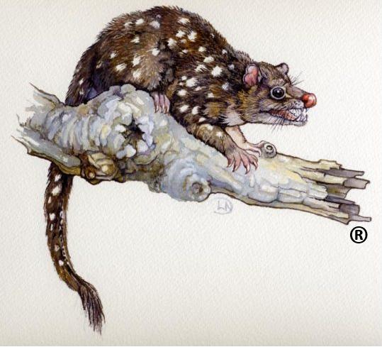
 Loading...