Australia has a history of national disasters, which our detached apathetic politicians repeatedly fail to plan for.Rockhampton Flood of 1918
http://www.rootsweb.ancestry.com/~auscqfha/floods.htm
.
The Central Queensland (CQ) Family History Association Inc. knows and respects the history of Central Queensland. It has well documented the flooding of the Fitzroy River through Rockhampton.
‘The Fitzroy River and its tributaries drain a vast expanse of country. Captain Cook, in the Endeavour, sailed along the eastern coast. On May 26, 1770, anchored in and named Keppel Bay, and Flinders, in the Investigator, anchored in the Bay, ascended Sea Hill, named Broadsound and found The Narrows, but failed to discover the great river coming down from the far interior of the continent. The streams that feed the Fitzroy flow through some of the richest grazing and agricultural lands in Queensland. Fresh water continues to some five miles (8 Km) past Yaamba, the old northern crossing 21 miles (33.8 Km) by road and 34 miles (54.7 Km.) by river from Rockhampton. Here tidal influence commences.’ ‘The country drained by the Fitzroy River is estimated to be 55,666 square miles (144,174 square Km.) of which 54,800 square miles (141,932 square Km.) is upstream from Rockhampton and because it drains an immense area it must, of course, carry enormous quantities of water at times.’
[Source: http://www.rootsweb.ancestry.com/~auscqfha/floods.htm ]
.
Indeed, Rockhampton has flooded many times throughout its history, mainly through the Wet Season.
And the 2011 flood is expected to peak at 9.4 metres – not as ‘unprecedented‘ as the politicians would have us believe.
.
.
Bligh Expects Queensland Flood Emergency to Exceed $5 Billion
.
Rockhampton Flood @ 9.2m in 2011
.
Rockhampton is again under flood along with many townships of central Queensland.
Today [5th Jan 2011] Queensland Premier Anna Bligh estimated that the total economic impact of the flood damage to Queensland could be $5 billion. Julia Gillard has previously said the Federal Government would be providing assistance that would run into the hundreds of millions to assist the recovery process. Clearly that falls well short of the $5 billion minimum estimated by the Queensland Premier.
And now the politicians are promising, pontificating and filibustering. The political party that herald’s itself as representative of rural Australians, the National Party, has called for a national disaster fund set up and that it be contributed by a household insurance levy. NSW Nationals Senator John Williams said Senator Boswell’s insurance levy should be replaced by a levy on council rates to catch all landowners.
Senator Williams has called for a debate around a national “emergency fund” of up to $10 billion that would help in the event of a flood or other disaster like drought, fire or earthquake.
“Bring on the debate, the money has to come from somewhere. We can’t just pluck it off trees,” he said. “I think a national fund would be a great step forward so the money is there when a fellow Australian is in need of it. There will obviously be some impact on the Australian economy but I would think the Australian economy is large enough and robust enough, as it does almost every year, to be able to cope with these sort of natural disasters,” he said. [1]
.
So serious is this round of disasters in Queensland, Australia’s Prime Minister ‘Julia Gillard ‘has ordered more government funds be diverted to flood-ravaged Queensland in a bid to prevent the state slipping into a long economic slump.’
‘In what may become Australia’s largest and most costly rebuilding operation, clean-up grants of up to $25,000, along with low-interest loans, were offered by the Prime Minister yesterday in addition to the commonwealth’s normal emergency relief payments. Production has almost ground to a halt in the coal industry, while early assessments of Queensland’s agriculture sector have put the cost of the floods at more than $1 billion in lost production.
Authorities also worry that receding floodwaters will reveal unexpected damage to infrastructure, raising the political pressure on all levels of government to chart a clear course to recovery.’ [2]
.
.
National Disaster Management Grossly Neglected in Australia
.
But yet again, after another natural disaster politicians cry to escape all implications of government culpability and so distract public attention by claim of ‘act of God‘ and ‘unprecedented‘ and calling for Australians to chip in and dig deep. Instead of confidently relying upon years of government investment in contingency planning and infrastructure, politicians become shy and distractingly appeal for ‘community spirit’. But now what choice does the community have now that a disaster is upon them? They only have community spirit, despite the bleeding guv’ment.
The floods have also badly affected New South Wales, the Gascoyne and western Victoria. This has included the NSW border town of Goodooga ‘which lies directly in the path of the Queensland floodwaters and is expected to be isolated by the weekend and could remain cut off for the next six weeks.’ The NSW Premier Kristina Keneally has said that evacuations are already underway. The NSW government has declared another eight local government areas to be natural disaster areas, bringing the total to 59. [3]
Also currently occurring is the severe flooding of the Gascoyne Region including the town of Carnarvon, 900km north of Perth. The State Fire and Emergency Services Authority is similarly advising residents to watch for changes in water levels and be ready to evacuate.’ [4] On 19th December 2010, the river had reached 7.7 metres and the president of the Carnarvon Shire, Dudley Masien described the flood the worst he had witnessed. “The hotel roof is only just peaking out of the water“, he said. [AAP 20101220].
Meanwhile in South Australia, over the 2011 New Year period temperatures had been forecast to be 40 degrees Celsius threatening “catastrophic conditions” for bushfire. Luckily an early change averted this risk, but even so several major fires have occurred across South Australia in the past few days including grass fires at Kangarilla, Salisbury East and Keith. The SA Country Fire Service has warned of very high danger ratings remain in place for the North-West Pastoral, North-East Pastoral, West Coast, Eastern Eyre Peninsula, Flinders, Mid-North Yorke Peninsula and the Riverland. [5]
Seriously, Australian governments at all levels need to stop their ‘too-little-too-late’ reactionary responses to emergency management in Australia . The Australian people, the Australian economy and the Australian natural environment deserve better. Currently, we have disparate grossly underfunded State run groups largely staffed by local volunteers – volunteer rural fire services, volunteer state emergency services, and total dependence upon various charities like the Red Cross and Salvation Army.
The responsibility for emergency management throughout Australia has been run on the cheap by successive State and Federal governments since Black Friday of 1939. National Disaster Management is probably the most neglected responsibility of all government services, because to do it right involves long term planning beyond election cycles and costs so much money.
Since Victoria’s catastrophic and multiple Black Saturday bushfires about this time two years ago, Australia has emerged from decades of prolonged drought across many states; as well as experienced wild damaging storms; and bushfires this summer in South Australia and WA (again deliberately lit). Australia has copped cyclonic conditions across the north and now flooding rains throughout central and southern Queensland and into northern regions of New South Wales. Each new year that comes the risk of damaging weather is not likely to wane.
Last September, Australia’s closest neighbour, New Zealand, suffered a devastating earthquake in Christchurch, and we don’t have to travel far back to recall the 2004 Indian Ocean Tsunami that devastated coastal Sumatra, Thailand, Sri Lanka and the Maldives.
Australia has a litany of disasters through its recent history:
March 1899: more than 400 die in Cyclone Martha at Cape York, far north Queensland.
December 1916: Flood kills 61 at Clermont, Queensland
April 1929: Northern Tasmanian floods kill 44
December 1934: Melbourne floods kill 36 and leave 3000 homeless
March 1935: Cyclone in Broome, West Australia kills 141
February 1955: Hunter Valley floods kills 25 in Singleton and Maitland, NSW
February 1967: Tasmanian bushfires kill 62, most in Hobart
January 1974: Brisbane floods kill 14 (Cyclone Tracy 25,000 made homeless)
December 1989: Earthquake in Newcastle, NSW kills 13
July 1997: Landslide at Thredbo, NSW kills 18
February 2009: Black Saturday bushfires in Victoria kill 173
and many others.
[Source: The Australian newspaper, ‘Summer, season of catastrophe’, 20110112, p.11]
.
What is Australia doing about National Disaster Management on its own doorstep and to prepare its poorer neighbours in the South West Pacific? Australia as a rich wealthy nation has a moral responsibility to harbour its close exposed neighbours.
But what disaster monitoring and preparation strategy does Australian have for weather research & monitoring, disaster contingency planning, investment in defensive infrastructure to ensure community resilience, damage mitigation, natural disaster response training?
Where is Australian political leadership in national emergency management?
Australia has a recurring pattern of natural disasters. Simple searches on Google reveal that weather history in Australia is only repeating itself. It’s not new. It’s not ‘unprecedented‘ as government politicians try to excuse their leader’s unpreparedness, or is it disinterest?
Classically in Australian literature, Dorothea Mackellar’s Australian epic poem ‘My Country’ prevails and I borrow the following pertinent excerpt, which is prone to regurgitated reference by the media:
“I love a sunburnt country,
A land of sweeping plains,
Of ragged mountain ranges,
Of droughts and flooding rains.
I love her far horizons,
I love her jewel-sea,
Her beauty and her terror —
The wide brown land for me!”
.
But bear in mind Mackellar wrote that poem back in 1904. She was insightful! Colonial Australia struggling out of raw survival in a retched landscape and through someone’s noble sense of ‘Federation’, Australians will have felt the natural onslaught of the ‘terror’ of natural disasters.
But surely a hundred years hence with the time and luxury of foreign lifestyle, our irresponsible governments do not deserve pardon for their gross public ineptitude.
The Australian Bureau of Meteorology has come out declaring it was well aware of the impending torrential downpour from the current La Ni√±a event and of the likelihood of extensive flooding pending for south east Queensland. Historically, La Ni√±a has always caused high flooding cross SE Queensland big river regions. Hello! So where were the Queensland Government’s risk assessment, contingency planning, infrastructure investment and community preparation to lessen the likely disaster scenarios for the big river communities? Is Bligh a joke talking?
We’re now in the 21st Century, not Mackellar’s era. Australians in all states and territories have a public right to expect that our Australian national government will dutifully properly prepare, manage and mitigate the impacts of national disasters. It is all about good governance. What do we pay taxes for if it is not for times like this?
While many of us who can take out general insurance, those insurance companies can only respond to natural disasters in a financial sense but after the disaster. But it is not the job of insurance companies to manage disaster; it is without equivocation the responsibility of government and quite simply that is why we must pay our taxes throughout our lives. Government civic infrastructure is still not in place to mitigate known historic recurring disaster risk and so since the risk remains so the proportional premium increases. Consequently, many thousands of Australians are in a Catch 22. They are not eligible or cannot afford the requisite insurance to cover their property against natural disaster because the premiums are prohibitively expensive, but they can’t sell and relocate because their property values will have plummeted.
Over the decades thousands of Australians have had their building approved by government on land with a history of natural disaster – flooding, bushfire and drought for instance. If that is not reckless enough, governments at all levels continue to renege on disaster risk mitigation and defensive infrastructure to withstand known disaster types. So in the event of these recurring natural disasters, look at the record of the Australian Government’s contingency planning and performance protecting the Australian public – their lives, property, and to Australia’s most vulnerable our wildlife and its natural habitat? Thousands of hectares of forests have been cleared across the Brisbane River that naturally would have absorbed much of the deluge. Now bare hills and hard surfaces and many thousands of storm water drains, the rains are not absorbed. Housing development continues to be approved in bush settings that are undefendable in the event of a bushfire. Agricultural approval is provided for cropping on marginal lands with repeated histories of drought and/or flood.
Unlike back in 1904, Australia in 2011 is supposedly a wealthy, technologically advanced society. Australia easily has the financial and resource capability to be disaster prepared at national level. But failure to contingency plan condemns Australians to ‘planning to fail‘. When disaster hits Australians are on their own! When a government lets down its people it has lost all legitimacy.
.
So what is ‘Emergency Management Australia’ ?
.
Nationally, Australia has no central organisation that deals with national disasters, natural or otherwise. The job is left to the relevant State Government concerned; somewhat a leftover remnant of colonialism.
There is a token agency under the Federal Attorney General’s Department, called Emergency Management Australia [compulsorily abbreviated to an acronym like most government agencies to ‘EMA‘, but the name is more impressive than the tasks it performs.
In 2005 under the Howard Government, Emergency Management Australia was on paper “tasked with co-ordinating governmental responses to emergency incidents” and with providing training [at Mount Macedon] and policy development, yet “the actual provision of most emergency response in Australia (was)… delivered by State Governments.”
In November 2007 under the Rudd Government, the Emergency Management Australia focus was modified, slightly:
“On request, the Australian Government will provide and coordinate physical assistance to the States in the event of a major natural, technological or civil defence emergency. Such physical assistance will be provided when State and Territory resources are inappropriate, exhausted or unavailable.” – and they gave it an acronym ‘COMDISPLAN‘ standing for Commonwealth Government Disaster Response Plan.
That is, in lay terms, the Australian Government will only help in national emergencies when the States can’t handle a public emergency.
Such a bureaucratic attitude is hardly proactive leadership from our wealthy developed nation!
.
In recent years, the Rudd/Gillard Government renamed the organisation Emergency Management in Australia (visit the site http://www.ema.gov.au/), which seems to have been a way of playing down its national leadership role to one of being simply an informational resource. Again, this is divulging responsibility for national emergencies to the next tier of government. Imagine if the states and territories did the same and divulged such responsibility down to local councils?
Emergency Management in Australia doesn’t even have a dedicated minister responsible. Instead, the entire responsibility is tagged on to the Federal Attorney General’s Department. Currently the task is being delegated to an ‘Acting’ Attorney-General Brendan O‚ÄôConnor and shared with Minister for Human Services Tanya Plibersek. It is as if the Australian Government has a head in the sand approach to national emergencies at home, hoping they won’t happen, but when they do, she’ll be right mate! – we’ll fob our way through it as best we can with what’s lying around.
What a bloody irresponsible approach to national emergency management! And all the government does is to encourage the thousands of Queensland residents affected by the flooding to lodge a claim for the Australian Government‚Äôs Disaster Recovery Payment ‘AGDRP‘ – another acronym!
Other reactionary responses from Canberra are currently listed on the EMA website as ‘Flood-affected residents urged to apply for assistance’, ‘Extra disaster assistance for flood-affected communities in Queensland’, a ‘Boost for Territory Disaster Resilience’, a ‘Boost for Tasmanian disaster resilience’, ‘Commonwealth response to the final report of the Victorian Bushfires Royal Commission’, and when in doubt, ring Triple Zero (000). How reassuring!
Perhaps one initiative positively worth noting is that the Council of Australian Governments (COAG) met in Brisbane on 7 December 2009 and agreed to a range of measures to improve Australia‚Äôs natural disaster arrangements. COAG recognised “the expected increase to the regularity and severity of natural disasters“, and so agreed to a new whole-of-nation ‚Äòresilience‚Äô based approach to natural disaster policy and programs.” Under a Natural Disaster Resilience Program, at Federal level we are now supposed to have Commonwealth funding for disaster mitigation works and support for emergency management will be approximately $110 million over four years.
Well at least it’s a step in the right direction – adopting a ‘whole-of-nation’ approach is long overdue. Yet the current funding scope again is classically ‘too-little-too-late‘. The politicians pontificate. How much of this $110 million will be required for the 2010 Queensland Floods disaster? How much reached the victims of the 2009 Black Saturday disaster across Victoria?
What inevitably happens is that when the disaster situation gets beyond the local volunteers and State and Federal Governments are in a lather not being able to cope, the standard response is to call in the Army? As if the Army knows better than the experienced volunteers?
But for a national government to resort to calling in the Army is a public confession that the government’s emergency management plan has utterly failed the people. At this very point government raises the white flag of failure in national emergency management. One’s government is suddenly incompetent.
And just like what the Federal Government did in Victoria after Black Saturday’s shemozzle of a disaster management, this is just what they are again doing now in Queensland. Enter Major General Mick Slater, poor bugger!
.
.
Army deployed to manage the 2011 Queensland Floods Recovery
.
On 5th January 2011, Queensland Premier Anna Bligh announced that Major General Mick Slater would lead the state’s flood recovery taskforce, as more than
200,000 Australians in 40 communities across Queensland have been impacted in some way by the floods. The Army will be tasked to rebuild houses, economies, regional communities and infrastructure. It is estimated that about 1,200 homes across Queensland have been inundated by floodwaters thus far, with another 10,700 homes affected and 4,000 residents evacuated, and the flood bill could be well above $5 billion.
But as a freshman to national disaster management, incoming Army officer Slater has revealed that despite his Army experience has not prepared him for this challenge:
…’one of his first duties will be to talk to Major General Peter Cosgrove, who headed the Innisfail rebuilding project after Cyclone Larry in 2006.
“I believe he’s returning from overseas today and I hope to speak to him tonight. This is early days for me. I’ve just been appointed to this job, but I do understand that time is of the essence as we progress down the recovery mode. However, it is very important that we get it right the first time. “If we rush in and do patch-up jobs… then we will have got it wrong. We must get it right from the start and that will take some time.”
.
[Source: ‘Army general to head flood recovery taskforce’, ABC, 5th January 2011, http://www.abc.net.au/news/stories/2011/01/05/3106898.htm ]
.
Reading between the lines, it is clear that the Army is not trained, skilled, experienced or prepared to deal with national disasters. The Army is traditionally trained to fight battles against a human enemy. It has recently evolved to deal with peacekeeping missions, but national disasters remain outside its core skill set.
Premier Bligh has recognised:
“This is a large and complex effort. It will not happen quickly. It will require all of us working together across different levels of government.”
And so once again, instead if a single national professional response, a hotch-potch of agencies is thrown together from Federal and State Governments. Volunteers and charities will play a key role and asking the public for charity has already started.
Once again a desperate government declares ineptness and phones a friend in Canberra – ‘please send in the Army and make our politicians look like we’re taking decisive action what now there’s a good chap, meet you at the club for afters’.
.
.
Australian Army Not Equipped for National Disasters
.
CRITICAL QUESTIONS: What does the Australian Army know about national disaster management? More that the State Emergency Services or Fire Brigades? I don’t think so. But the Army has resources, and that it why it is brought in. So why don’t the emergency agencies have the resources in the first place? Emergency agencies do emergencies. The Army fights wars.
.
Let’s look at the record…
Army Deployed to Manage the Recovery after the 2009 Victorian Bushfire Disaster
Between 10th February and 14th March 2009, Australian Prime Minister Rudd and Victoria‚Äôs Premier Brumby agreed to have the Australian Army Reserve deployed to assist the multiple emergency services in the immediate aftermath ‘mopping up’ of the Victorian bushfire emergency, dubbed by the media as ‘Black Saturday‘. The Army set up Joint Task Force 662 based to the north of Melbourne under the command of Brigadier Mike Arnold.
Under ‘Operation VIC FIRE ASSIST’, Joint Task Force 662 involved about 450 Army Reservists in a recovery support role – mainly a construction and an engineering regiment with assistance from the School of Armour and a Combat Services Support Battalion. Specifically, ‘Search Task Group’ was set up comprising around 160 Army Reserve soldiers to assist police locate human remains with perimeter security around many townships and residents destroyed including the two Kinglakes, Strathewen, Marysville, and Flowerdale. An RAAF AP-3C Orion aircraft was deployed to provide aerial imagery to assist in the identification of residences affected by the fires.
Army support included delivering food parcels, and putting tents and facilities into place to help accommodate, feed and support people left homeless.
An Engineer Support Group, comprising around 70 personnel, five army bulldozers, a front-end loader and a grader, working with the Victorian Department of Sustainability and Environment and Country Fire Authority, to assist with improving fire breaks and containment lines, and clearing roads of vegetation and debris throughout the many bushfire affected areas.
Somewhat outside core duties, Defence personnel from Northern Command and Townsville launch bushfire undertook direct fundraising collecting donations at the gates to Larrakeyah Barracks, Northern Territory and Lavarack Barracks, Townsville. On Friday 13th February five RAAF members from Combat Support Unit Edinburgh also conducted a collection in aid of the Red Cross Bushfire Appeal at the main and south gates of RAAF Base Edinburgh.
So the Army involvement in dealing with the national disaster of ‘Black Saturday‘, was effectively a post-disaster mop up operation assisting police and providing civil engineering support and relief effort. The Army was not deployed at the outset of the known bushfire risk on Monday 3rd January 2009 when weather forecast was extreme and fires had already started. Nor was the Army deployed during the disaster period itself – Saturday 9th through Monday 11th January. This is due to the Army not being best trained to deal with such emergencies and the false expectation that the volunteer Country Fire Authority were.
The emergency conditions were such:
“The majority of the fires ignited and spread on a day of some of the worst bushfire-weather conditions ever recorded. Temperatures in the mid to high 40s (¬∞C, approx. 110‚Äì120¬∞F) and wind speeds in excess of 100 kilometres per hour (62 mph), precipitated by an intense heat wave, and almost two months of little or no rain fanned the fires over large distances and areas. “
[http://en.wikipedia.org/wiki/Black_Saturday_bushfires]
.
.
Army Deployed to Manage the Response and Recovery after Cyclone Larry in 2006
Severe Tropical Cyclone Larry made landfall in Far North Queensland as a Category 4 storm crossing the coast near Innisfail at dawn on 20 March 2006. With wind gusts up to 240kph Cyclone Larry was regarded as the most powerful cyclone to affect Queensland in almost a century. In addition to the high winds, the cyclone moved inland and developed into a tropical depression causing protracted torrential rains and extensive over the following week.
The wind and flooding damage extended north to Cairns and the Atherton Tablelands and as far west as Mount Isa. After landfall, Tropical Cyclone Larry moved over north-western Queensland on 22‚Äì23 March, with heavy rain falls across the region. Most of the damage occurred in the Innisfail coastal region where 80% of buildings were damaged, power and phone lines were downed, water was contaminated and the region’s main agricultural crop, bananas, was decimated. The economic damage bill came to around A$1 billion in damage, and there was one fatality.
The usual array of disparate organisations attended the immediate emergency response including the standard local emergency services (fire brigades, ambulance and police) as well as local volunteer fire brigades (Thuringowa) and unpaid State Emergency Service volunteers. Perhaps unlike other states, the umbrella organization Emergency Management Queensland initially led and coordinated the disaster management (response and recovery) including SES, Emergency Service Units, and EMQ Helicopter Rescue.
Local councils were handed authority to enforce mandatory evacuations once Queensland Premier Peter Beattie declared Larry a ‘disaster situation’. Desperately though, even local prisoners who ‘could be trusted’ were considered for recovery and clean up work-gangs, then around 150 tradesmen from around Australia arrived in Innisfail within days to repair houses, schools and public buildings.
The Australian Army was also deployed early. Within hours of the cyclonic winds subsiding, the nearby Townsville-based 3rd Brigade and Cairns-based 51st Battalion were deployed as well as the Far North Queensland Regiment. Three UH-60 Black Hawk helicopters were reserved for rescue and logistical support. A Combat Services Support Battalion was set up to manage the disaster relief effort based at Innisfail Showgrounds to provide basic food, water, shelter and sanitary needs to evacuated residents. Onsite health care, environmental advice, fresh food and purified water (as well as testing local supplies), tarpaulins, bath and shower facilities, and up to 500 beds were provided.
The Navy and Air Force were also deployed including a CH-47 Chinook heavy lift helicopter, one Seahawk helicopter, three Navy Balikpapan class LCH Landing Craft, two Caribou aircraft, two C-130 Hercules, and several LARC-V amphibious 4WD vehicles.
By 23rd March, three days after the cyclone hit, Prime Minister John Howard and Premier Beatty appointed former Chief of the Australian Defence Force, General Peter Cosgrove, to take charge of recovery efforts labelled the ‘Cyclone Larry Taskforce‘. One quick decision made by Cosgrove was to call for an economic assessment by state and federal governments, and specified a moratorium on businesses’ debt repayments to banks for 3 months. (An outside the Army square type of thinking).
Previously as a Major General in the Army, Cosgrove had successfully managed the 1999-2000 complex UN INTERFET peacekeeping taskforce in East Timor dealing with post-war humanitarian and security crisis. He was credited with commanding thousands of personnel from many countries and completing a successful mission to transition the country to relative stability.
[Source: http://en.wikipedia.org/wiki/INTERFET]
.
This experience had given Cosgrove disaster management skills beyond traditional Army combat roles, and clearly had well prepared him to lead the Cyclone Larry Taskforce. But Cosgrove’s peacekeeping civil emergency experience in a complex environment singled him out as the best person to lead the management of a national disaster in Australia. His success ought to serve as a model for future emergency management planning.
Yet Cosgrove’s experience is atypical of the Australian Army’s broader experiences. The Army’s role and experience in national disasters has been purely responsive and supportive. The main contributions by the Army in national disasters has been using Army equipment and military training to try to help a civil emergency. Following desperate orders from the Prime Minister of the day, the Army responds the best it can with what it has got in a situation it is not expertly trained or resourced to do professionally. The Army’s role in emergency management is not strategic, national nor involved in risk assessment, contingency planning nor leadership of the emergency response. But it should be.
The Australian Regular Army and its volunteer Army Reservists are tasked for traditional military combat, not for the new emerging role of international peacekeeping, nor for managing civil unrest, nor for anti-terrorism, nor for natural and national disaster management. Yet recent world events and trends point to such roles becoming more important and likely than traditional military combat. So the role of the Army, its capabilities and its culture need to change to better meet Australia’s true ‘defence’ needs in the broader 21sst Century context. The Army’s 20th Century traditional military combat role belongs to the 20th Century.
.
.
Irresponsible to Expect State-based Volunteers to Manage National Disasters
.
Tropical cyclones are not new in northern Queensland nor indeed across northern Australia. They invariably occur every Wet Season generally between the months of November and April and each year only varies in their intensity. This author experienced Cyclone Joy back in 1990 while living in Cairns. The need for a national disaster management organisation probably dates back to Cyclone Tracy of Christmas 1974 which flattened Darwin.
Australian natural history is one of recurring natural disasters. Current flooding along the Murrumbidgee River in New South Wales is again affecting the town of Gundagai, but since Australian history is poorly taught these days, few will be aware that a major flood back in 1852 wiped out the original town site of 71 buildings, and 89 of the town’s 250 inhabitants perished.
Bushfires, severe storms and cyclones, prolonged droughts, flooding rains, and even earthquakes have frequented the landscape, almost annually. With climate change apparent, however caused, there is every expectation from climate science that extremes of weather in Australia, around the world and in our region, will not lessen but more probably will increase both in frequency and severity. New forms of natural disaster may also occur in future such as tsunamis, landslide (recall Thredbo 1997), storm surge, even possible tornado or tsunami, a volcanic eruption from our north or plague and pestilence. National disasters affecting Australia and our region may also not only be naturally caused, such as a major bridge collapse, major dam collapse, major gas explosion and given ongoing tensions and terrorist events pervading our now global society, new forms of national disaster may loom.
While the 1939 ‘Black Friday’ bushfires in Victoria killed 71 people, the accompanying heat wave – which triggered the blazes – claimed 438 lives and yet remains largely unacknowledged. With climate change, a recurrence is almost certain.
Is Australia prepared to cope, manage and mitigate the effects of national disasters? Is the current emergency management framework centred on State-based and local volunteers adequate to the task?
In localised low grade emergencies, the current system generally copes well. But when it comes to national disasters like Cyclone Larry, Black Saturday and the 2011 Queensland Floods, the answer is clearly ‘no’. The test is, do most Australians believe that the emergency authorities in each case were sufficiently prepared and resourced and adequately responded? Do most Australians believe that the impacts of these national disasters could have been considerably mitigated by better risk assessment, contingency planning, the immediacy and appropriateness of the response and co-ordination of recovery?
Such questions go the core of Australia’s national security and to the role and expectation of government to protect its people and assets. The concept of ‘national security‘ needs to extend beyond the narrow military sense to encompassing defence against all forms of adverse impact to our society, economy and environment. National security also extends to Australia’s immediate region; since to ignore national disasters of our neighbouring nations would be not only immoral but likely have spillover effects on Australian eventually.
So what to do about the problem of recurring national disasters?
Government urban planning, human settlement approvals and investment in civic infrastructure to properly protect its citizens from the impacts of national disasters, and the funding of general and life insurance are interrelated key socio-economic issues that will likely come to the fore as communities recognise history repeating itself and governments are found wanting – but they are a focus is for another article.
The contention in this article is not to criticise the work of emergency service volunteers and professionals of the many organisations that get involved, but rather to highlight that the framework and resources in which they operate is woefully inadequate. Volunteers must feel like pawns in a loosely run reactive system, but culturally they are condemned if they dare criticise.
Yet the repeated evidence is that Australia’s current emergency management framework fails the delivery and performance expectations of Australians in our wealthy and advanced society. Look at the records since the first national disaster of the 1939 Black Friday bushfires! Below in the Further Reading section, a number of online references provide links to the many national disasters throughout Australian history. Natural history is repeating itself, but regrettable so is the laissez faire, even ‘head-in-the sand’ attitude of successive Australian governments to avoid serious investment and planning in emergency management for national disasters.
National disasters are costing Australian lives, communities, economies and environments. The full triple-bottom-line costs (direct and indirect) cumulatively reach the billions almost annually. The cost has to be paid in one way or another and often it is in the form of economic loss, decline in rural society and environmental degradation. Instead of governments investing billions up front to mitigate the damage and costs, governments are forking out afterwards anyway and Australian morality is tweaked to donate in order to make up the funding shortfall. The old adage of ‘prevention being better than the cure‘ holds so true here, but the solution seems beyond the short term narrow thinking of our political leaders.
.
‘So serious is this round of disasters in Queensland the Prime Minister ‘Julia Gillard has ordered more government funds be diverted to flood-ravaged Queensland in a bid to prevent the state slipping into a long economic slump.’
.
In what may become Australia’s largest and most costly rebuilding operation, clean-up grants of up to $25,000, along with low-interest loans, were offered by the Prime Minister yesterday in addition to the commonwealth’s normal emergency relief payments. Production has almost ground to a halt in the coal industry, while early assessments of Queensland’s agriculture sector have put the cost of the floods at more than $1 billion in lost production.’
.
[Source: ‘PM Julia Gillard to help flood-hit Queensland weather storm‘, by Sean Parnell and Jared Owens, The Australian, 4th January 2011. http://www.theaustralian.com.au/national-affairs/pm-julia-gillard-to-help-flood-hit-queensland-weather-storm/comments-fn59niix-1225981305357 ]
.
“Surely it’s time for Julia Gillard to stop seeing the Queensland floods as a series of media opportunities and start showing some practical leadership. She does not appear to have had the truly national implications of this disaster made clear to her.”
[Source: David Williams, Frewville, SA, Letter to the Editor, The Australian, 20110112, p13)
.
.
Full Costs of National Disasters Many Times Greater than Government Investment in its Volunteer Emergency Management Model
.
http://on-walkabout.com/tag/bushfires/
.
Economic Cost of National Disasters of Living Memory
In terms of direct economic damage alone, in Australian dollars the Queensland Bligh Government has estimated the cost of the current 2011 Queensland Floods to exceed $5 Billion. The economic damages bill for the 2009 Victorian Bushfires exceeded $2 billion. The economic cost of the 2006 Cyclone Larry was in excess of $1.5 billion. The 2003 Canberra Bushfires insurance cost came to $250 million. The 1991-95 drought across in north-eastern New South Wales and much of Queensland cost the economy around $5 billion.
In 1990, over one million square kilometres of Queensland and New South Wales (and a smaller area of Victoria) were flooded in April 1990. The towns of Nyngan and Charleville were the worst affected with around 2,000 homes inundated. Six people were killed and around 60 were injured.
The insurance claims payouts from the 1983 Ash Wednesday Bushfires for Victoria and South Australia combined were $1.3 billion (2007 adjusted terms). The preceding four-year drought across south-eastern Australia (1979-1983) cost the economy around $7 billion mainly in agricultural losses.
In January 1974, the weakening Cyclone Wanda brought heavy rainfall to Brisbane and many parts of south-eastern Queensland and northern New South Wales. One third of Brisbane’s city centre and 17 suburbs were severely flooded. Fourteen people died and over 300 were injured. Fifty-six homes were washed away and 1,600 were submerged. At Christmas 1974 Cyclone Tracy killed 65 people and caused over 600 injuries in Darwin and 70% of all houses had serious structural failure. The total damage bill was around $800 million (1974 $s). In 1970 Tropical Cyclone Ada caused severe damage to resorts on the Whitsunday Islands, Queensland. Fourteen people were killed and the damage bill was estimated at $390 million.
Many other national disasters have occurred in Australia as well as in neighbouring countries. The 2004 Indian Ocean Tsunami claimed more than 150,000 people dead or missing and millions more were homeless in 11 countries, making it perhaps the most destructive tsunami in history. An estimate by the World Bank and Indonesian government put the total bill for the destruction of property and businesses at more than US$4.4 billion.
Many minor emergencies that occur each year particularly involving storms and bushfires would add to the aggregate costs of these major events.
So a broad brush stroke estimate of the direct economic costs alone of national disasters affecting Australia would average in the range of between $2 billion and $5 billion per year. This excludes the social costs of people experiencing trauma and losing loved ones and livelihoods as well as the unknown environmental costs which should be measured and included and disclosed by the Australian Government so that the cost truth of national disasters is know to the Australian public. Without triple bottom line measurement, the true scale of the problem remains hidden and the ability to problem solve and to make cost effective and cost benefit investment decisions is greatly diminished.
.
Disaster Compensation
So in the current instance involving the 2011 Queensland Floods, Prime Minister Gillard has promised a $25,000 grant to each flood-affected property owner and $15,000 to those similarly affected in the flooded Gascoyne Region of Western Australia. Assumedly, flood-affected property owners in northern New South Wales will be similarly compensated. Under Queensland’s Natural Disaster Relief and Recovery Arrangements (NDRRA) the State and Federal Governments share the compensation costs and include other Disaster Relief Measures such as providing Counter Disaster Operations and a Personal Hardship Assistance Scheme (to alleviate personal hardship), an Associations Relief Assistance Scheme, Restoration of Public Assets, Concessional Loans to Primary Producers, Freight Subsidies to Primary Producers, and Concessional Loans to Small Businesses.
But the financial compensation offered by the Australian government varies with each national disaster and the aggregate cost information is not readily available online, perhaps intentionally. In the main, each state government sets up a range of compensation funds on a disaster event basis. The Australian Government provides a website Disaster Assist that summarises what compensation is available for a given disaster event, usually with references to CentreLink and back to the relevant state government. Visit: http://www.disasterassist.gov.au/www/disasterassist/disasterassist.nsf/
In the case of the 2011 Queensland Floods disaster, an Australian Government Disaster Recovery Payment rate is $1,000 per eligible adult and $400 per child.
“Claims for this assistance can be lodged at Centrelink until 4 July 2011 as application for the payment is available for a period of up to six months.”
Identified Disasters on the website are listed as follows:
Current Disaster Assistance
* Queensland Floods – December 2010
* Financial assistance for flooding and severe weather events November – December 2010
* NSW Flooding – October 2010
* South East Queensland Flooding – October 2010
* New South Wales Weather Event – September 2010
* Victorian Flooding – September 2010
* Victorian Bushfires – January/February 2009
.
Previous Disasters
* Victorian Storms – March 2010
* Queensland Floods – March 2010
* WA bushfires December 2009
* Mid-North Coast Flooding – November 2009
* Samoa Tsunami – September 2009
* Human Swine Influenza (H1N1) Outbreak 2009
* New South Wales Floods – March 2009
.
Annual Funding in Australian Emergency Management
On 12th May 2009, the Rudd Federal Government issued a media release entitled ‘Improving Disaster Resilience‘ as part of the Federal Budget 2009-2010. It stated:
‘The Rudd Government will invest $79.3 million to strengthen efforts to prepare for and combat major natural disasters.
A comprehensive ‘Disaster Resilience Australia Package’ will integrate a number of existing emergency management grant programs, providing the flexibility to effectively meet the requirements of local communities threatened by disaster. The additional funding will be part of this new package.
…The package will integrate the current Bushfire Mitigation Program (BMP), Natural Disaster Mitigation Program (NDMP), and the National Emergency
Volunteer Support Fund (NEVSF). The funding will:
support disaster mitigation works including flood levees and fire breaks
assist Local Government meet its emergency management responsibilities
support the work of volunteers in emergency management
build partnerships with business and community groups to improve their ability to respond to emergencies.
…In addition, the Commonwealth will also provide more than $12.8 million over the next four years to assist States and Territories lease additional fire fighting aircraft for longer periods during bushfire seasons.
Aircraft will be leased through the cooperative National Aerial Firefighting Arrangements (NAFA) and will help individual States and Territories access a range of specialised aircraft that would otherwise be out of reach.
“Aerial firefighting has emerged as a valuable tool in the fight against bushfires and the national arrangements have proven to be an efficient, collaborative approach that shares the cost of these specialised assets,” Mr McClelland said.
This additional funding brings the Government’s total contribution to the National Aerial Firefighting Arrangements to $14 million per year from 2009-2010.
Following recommendations of the 2008 Homeland and Border Security Review, the Government will also establish new briefing facilities and establish an enhanced Government Coordination Centre to support decision-making in the event of a national crisis or major natural disaster.’
[Source: Australian Government – Attorney General’s Department]
.
On 8th June 2010, the New South Wales Keneally Government announced it would invest $972 million in emergency services across NSW, including the NSW Fire Brigade, NSW Rural Fire Service and NSW State Emergency Services.
The NSW Emergency Services Minister, Mr Whan states:
“Our emergency services are our first line of defence against storms, floods, tsunami, fires and other emergencies and it is vital that they have the personnel, facilities and resources they need to protect communities around NSW.”
“…Over the past two years, our SES volunteers have responded to a string of emergencies, including major floods in Northern NSW, the Central West and Far West.
“Given the predicted impacts of climate change, this workload is expected to increase in coming years and it is important that the SES is ready to face the challenges ahead.”
The Budget highlights for the emergency services were listed as follows:
NSW Fire Brigades (professionally paid)
The NSW Fire Brigades 2010/11 budget is $637 million. Spending includes:
* $18 million for more than 35 new fire engines and specialised vehicles
* $8.4 million for firefighting and counter terrorism plant and equipment
* $10 million for Cabramatta and renovated fire stations and training facilities
* $2.5 million for Community Fire Units
* $1.3 million for a Workplace Conduct and Investigation Unit
. NSW Rural Fire Service (largely unpaid volunteers)
The Rural Fire Fighting Fund for 2010/11 is $220.4 million. Spending includes:
* $32.2 million for about 200 bush fire tankers
* $16 million for new and renovated stations and fire control centres, including installing water tanks
* More than $17 million for bush fire mitigation, including $6.7 million for works crews
* $7.8 million for aerial firefighting resources
. NSW State Emergency Service (largely unpaid volunteers)
The State Emergency Service budget for 2010/11 is $64.1 million. Spending includes:
* $2 million to assist with the cost of about 60 emergency response vehicles
* $1.4 million for rescue equipment, including $600,000 for about 20 floodboats
* $1.4 million for communication and paging systems
* $930,000 towards the cost of upgrading unit headquarters around NSW
[Source: http://www.nswfb.nsw.gov.au/news.php?news=1656 ]
.
The division of emergency services management by the State of NSW into three separate governments agencies, of which only the urban-based fire brigade is fully professionally paid, is typical of the other Australian states and territories. NSW is the most populous state in Australia and so has the greatest taxation revenue with which to fund its public services such as emergency services. An actual annual aggregate figure of the combined capital and recurrent expenditure on emergencies services across Australia would be welcomed and should be disclosed on the Australian Government’s website.
But for a quick comparison, let’s assume that the annual aggregate investment by governments at all levels across Australia, including that of local councils is in the range of $3 billion to $4 billion per year. The investment is almost on par with the economic cost outlay of Australia’s national disasters. It is important to recognise that the funding cost is separate from the disaster economic cost, and that the socio-environmental costs are excluded.
So Australia’s total economic spend on national disasters and civic emergencies probably averages close to A$10 billion per year.
.
.
A Case for Disaster Management to be ‘professionally nationalised’ across Australia.
Why are national disasters causing such massive impact on Australia’s environment, society and economy?
Is the damage caused by natural disasters impossible to mitigate (a fatalistic acceptance), or can more be done to mitigate their damage to the environment, society and economy?
Does Australia have a history of natural disasters and are any of the recent ones socalled ‘unprecedented‘ or are they just a repeat of what has gone before and even less severe than previously?
Who is responsible for planning and mitigating the impact of national disasters when they do occur?
Is not national disaster management as vital a function as military defence?
Is the current framework of multiple disjointed independent State and locally based organisations the most effective and efficient structure to do the job?
What if Australia’s Defence Force had the same framework and organisational structure as current emergency management? Could Australia’s Defence Force perform the same as it currently does? Why not?
How is current disaster contingency planning and response performance measured and are the measures appropriate to quantifying the desired standards of performance?
Is the current disaster contingency planning and response performance acceptable to the Australian community?
How short of ideal is the current performance?
Why is the current emergency management response not able to mitigate the impact to an acceptable level?
How do Australia’s emergency management operations measure up against world best practice?
What countries have world best practice emergency management?
Does the funding structure facilitate or inhibit the capacity of the emergency planning and response?
Are grants and subsidies an appropriate revenue source for such a vital service?
Ought funding be guaranteed as it is with the Defence Forces?
What are the alternatives to Australia’s current disaster contingency planning and response framework?
Do other countries have a proven success record of disaster contingency planning and response, which Australia could learn from and adapt?
.
.
United States: Federal Emergency Management Agency
.
Probably the global best practice structure currently for dealing with national disaster management (from risk assessment through reconstruction phasing) exists not surprisingly with the United States of America. Try searching elsewhere and frankly, the US is hard to beat.
The United States National Response Framework (NRF) is part of the National Strategy for Homeland Security that presents the guiding principles enabling all levels of domestic response partners to prepare for and provide a unified national response to disasters and emergencies.
Until 1979,the United States had no comprehensive plan for federal emergency response. Then President Jimmy Carter signed an executive order creating the Federal Emergency Management Agency (FEMA), which consolidated the emergency response duties from multiple agencies across the country that each had disjointed emergency operational plans. National legislation was enacted in 1988 to effectively nationalise Federal response to disasters. Under the National Contingency Plan, multiple organisations were united to deal with disaster preparedness and response.
In 1992, US President Bill Clinton appointed James Lee Witt as the head of FEMA, who substantially changed FEMA to adopt an all-hazards approach to emergency planning. Clinton elevated Witt to a cabinet-level position, giving the Director access to the President. So for the first time, a national disaster management organisation had a National Response Plan and reported directly to the head of the US government – the President.
Since then, following the 2001 September 11 terrorist attacks, the United States thrust disaster management to the forefront of national priority for obvious reasons and it is due to this that the United States probably more than any other country, bar perhaps Israel, has a world leading disaster management structure today. Since 2003, the Department of Homeland Security has absorbed FEMA and since 2008, the National Response Plan has been replaced by the National Response Framework.
The United States National Response Framework (NRF) is part of the National Strategy for Homeland Security that presents the guiding principles enabling all levels of domestic response partners to prepare for and provide a unified national response to disasters and emergencies. Building on the existing National Incident Management System (NIMS) as well as Incident Command System (ICS) standardization, the NRF’s coordinating structures are always in effect for implementation at any level and at any time for local, state, and national emergency or disaster response.
.
.
NRF five key principles
.
Engaged partnership means that leaders at all levels collaborate to develop shared response goals and align capabilities. This collaboration is designed to prevent any level from being overwhelmed in times of crisis.
Tiered response refers to the efficient management of incidents, so that such incidents are handled at the lowest possible jurisdictional level and supported by additional capabilities only when needed.
Scalable, flexible, and adaptable operational capabilities are implemented as incidents change in size, scope, and complexity, so that the response to an incident or complex of incidents adapts to meet the requirements under ICS/NIMS management by objectives. The ICS/NIMS resources of various formally-defined resource types are requested, assigned and deployed as needed, then demobilized when available and incident deployment is not longer necessary.
Unity of effort through unified command refers to the ICS/NIMS respect for each participating organization’s chain of command with an emphasis on seamless coordination across jurisdictions in support of common objectives. This seamless coordination is guided by the “Plain English” communication protocol between ICS/NIMS command structures and assigned resources to coordinate response operations among multiple jurisdictions that may be joined at an incident complex.
Readiness to Act: “It is our collective duty to provide the best response possible. From individuals, households, and communities to local, tribal, State, and Federal governments, national response depends on our readiness to act.”
.
.
‘NRF CORE’
.
Roles and responsibilities at the individual, organizational and other private sector as well as local, state, and federal government levels
Response actions
Staffing and organization
Planning and the National Preparedness Architecture
NRF implementation, Resource Center, and other supporting documents incorporated by reference
.
.
NRF ANNEXES
.
* ESF #1 – Transportation
* ESF #2 – Communications
* ESF #3 – Public Works and Engineering
* ESF #4 – Firefighting
* ESF #5 -Emergency Management
* ESF #6 – Mass Care, Emergency Assistance, Housing, and Human Services
* ESF #7 – Logistics Management and Resource Support
* ESF #8 – Public Health and Medical Services
* ESF #9 – Search and Rescue
* ESF #10 – Oil and Hazardous Materials Response
* ESF #11 – Agriculture and Natural Resources
* ESF #12 – Energy
* ESF #13 – Public Safety and Security
* ESF #14 – Long-Term Community Recovery
* ESF #15 – External Affairs
.
.
NRF SUPPORT ANNEXES:
.
* Critical Infrastructure and Key Resources (CIKR)
* Financial Management
* International Coordination
* Private-Sector Coordination
* Public Affairs
* Tribal Relations
* Volunteer and Donations Management
* Worker Safety and Health
.
.
NRF INCIDENT ANNEXES:
.
* Incident Annex Introduction
* Biological Incident
* Catastrophic Incident
* Cyber Incident
* Food and Agriculture Incident
* Mass Evacuation Incident
* Nuclear/Radiological Incident
* Terrorism Incident Law Enforcement and Investigation
.
.
.
Proposed New Defence Corps: Australia’s ‘Civil Emergency Corps‘
.
As one solution to Australia’s failing governance of national disasters, I propose the complete overhaul of Australia’s current state-based and volunteer based disparate organisations, by consolidating, nationalising and professionalising them all into one. I propose a new national defence corps be established under new national legislation – Australia’s ‘Civil Emergency Corps‘. This Corp would be an equal partner with our Army, Navy and Air Force, but instead of focusing on national defence against human-based threats, the Civil Emergency Corps will focus on national defence against mainly natural threats.
.
A special national commission should be established by the Australian Government to review and shape the purpose, functional scope, framework, organisation structure and strategies of this new corps. The initial intent is that this Civil Emergency Corps is to be modelled along the lines of the United States Federal Emergency Management Agency (FEMA) and the Federal National Response Framework (NRF), but tailored to Australia’s specific needs and circumstances. The design of the organisation will be based on input received from current emergency personnel, emergency experts and from the broader Australian community. Ideas from comparable organisations overseas will also be considered, such as from nations having proven effective national civil defence organisations.
Funding is to be on par and have the same budget process as the Australian Regular Army. No more raffles, grants and fund raising. The organisation would be professionally paid, run in a military structure and discipline. Like the Army it would have core full-time regulars and a part-time reserve component. It would be initially staffed by the current people already performing emergency service work. Over time the organisation will evolve to coming up to par with the equivalent performance standards as the Army. It’s resourcing would be exponentially increased to equip it to being a national effective fighting force to deal with national emergencies, properly.
.
Essential Functions of the Civil Emergency Corps
.
All the work of the State Emergency Services, Fire and Rescue Agencies
Disaster Risk, Contingency, Mitigation Planning – from local to national and indeed regional scale
Community Education in Natural Disaster Preparation and Mitigation
Post-disaster review an analysis and recommendations for future best practice and preparation to the Federal Government
Ongoing national disaster research input
.
Mascot
.
Australia’s magnificent wedge-tailed eagle should be the mascot of this new organisation. It is uniquely Australian, a highly respected native bird and the eagle traditionally is a symbol for guardianship, protection, power, strength, courage, wisdom and grace. All these qualities quite apt for a Civil Emergency Corps. An appropriate motto is ‘defending our community‘ – but instead of in English or translated back to Latin, better in Australian Aboriginal.
4. Civil Emergency Corps / Civil Emergency Reserve
State Corps
Regional Brigades
Local Units
.
.
National Government Ministry
Minister for Civil Emergency
Deputy Minister for Civil Emergency
Parliamentary Secretary for Civil Emergency
.
Organisational Structure
In the same way as Australia’s three other corps are configured, the new Civil Emergency Corps is to be comprised of ‘Regulars‘ – full-time and professionally paid, as well as ‘Reservists‘, who commit on a part-time on demand basis, who are professionally trained and paid commensurate on time served.
The organisational structure is to geographically-based into a respective ‘State Corps‘ for each State and Territory, then into ‘Regional Brigades‘ and then at local level into ‘Local Units‘. Each component will have its share of regulars and reservists. The existing infrastructure of the various emergency services agencies would be utilised.
In addition, in order to deal with highly specialised functions, dedicated Corp Specialist Regiments will be established (see proposed list below).
.
A ‘National Command Centre’
headed by the Corps General Marshall
based in Canberra next to the Bureau of Meteorology (BOM), for strategic reasons
.
State & Territory Corps
each headed by a ‘Corp Brigadier’
organisation structure based on a hybrid geographical model of both Fire Brigades and State Emergency Service, decided on a region by region assessment
.
Regional Brigades
each headed by a ‘Regional Commander’
.
Local Units
each headed by a ‘Unit Captain’
Note: Currently, in the New South Wales State Emergency Service (SES), NSW is divided into 17 ‘Regions’ based on major river systems.
‘Each of the 226 volunteer units belongs to a Region, which is led by a Region Controller. Region boundaries coincide as nearly as possible with major river systems. Each Region Controller is responsible for the operational control of emergency flood and storm responses, including planning, training, operational support and other functions within their area of control. The Region Headquarters also provides administrative support to the units in its region. The Region Headquarters all have fully functioning Operations Centres and a group of volunteers who help with training, planning, operational and other functions.’
Merger and Integration of the following national organisations into the new Civil Emergency Corps:
Emergency Management Australia
Care Flight Group
Australian Volunteer Coast Guard
St John Ambulance Service
.
.
NSW Corps
A merger and integration of the Fire and Rescue NSW, NSW Rural Fire Service, NSW Police Rescue Unit, Westpac Rescue Helicopter Service (NSW), CareFlight Group, Marine Rescue NSW, Community Emergency Services Incorporated
.
Victorian Corps
A merger and integration of the Victorian Fire Brigade, Country Fire Authority, State Emergency Service, Search and Rescue Squad (of the Victorian Police).
.
Queensland Corps
A merger and integration of the Queensland Fire and Rescue Service, Queensland State Emergency Service and Volunteer Marine Rescue, Queensland Rural Fire Service, RACQ CareFlight, Capricorn Helicopter Rescue Service (Rockhampton), Royal Flying Doctor Service, Volunteer Marine Rescue Association of Queensland.
.
South Australian Corps
A merger and integration of the South Australian Metroplitan Fire Service, Country Fire Service, State Emergency Service, South Australian Sea Rescue Squadron.
.
ACT Corps
A merger and integration of the ACT Fire Brigade, ACT State Emergency Service, ACT Rural Fire Service.
.
West Australian Corps
A merger and integration of the Fire and Emergency Services Authority of Western Australia (which has already merged its emergency service agencies), and the Volunteer Marine Rescue Western Australia.
.
Northern Territory Corps
A merger and integration of the Northern Territory Fire and Rescue Service, Northern Territory Emergency Service, Bushfire Volunteer Brigades, Rescue Co-ordination Centre (Northern Territory Transport Group).
.
Tasmanian Corps
A merger and integration of the Tasmanian Fire Service, State Emergency Service Tasmania, Tasmanian Air Rescue Trust, Sea Rescue Tasmanian Inc.
.
.
Corps Specialist Regiments
Each specialist regiment shall have its own part-time payrolled Reserve component.
.
‘Evacuation Regiment’
emergency field transport and logistics to effect evacuation of people and their personal effects
assumes basic human needs provision of displaced persons (emergency accommodation, food and clothing, emergency sanitation, emergency childcare
currently performed by charity groups like The Salvation Army, The Australian Red Cross, St Vincent de Paul Society, Anglicare Australia, Mission Australia, Catholic Mission, and others
.
‘Utilities Regiment’
public utility repair and rebuilding – drinking water, sewage and sanitation, electricity, gas services
Corps internal communications including satellite, (attached to Army Signals), plus public communications – land phone, mobile/SMS, public broadcast services, internet services, including evacuee/missing persons database and related communications
.
‘Search and Rescue Regiment’
assumes landsearch and rescue functions previously performed by various State Police special units
.
‘Maritime Regiment’
assumes functions previously performed by Coast Guard, including sea search and rescue and vessel salvage functions
.
‘Medivac Regiment’
assumes functions previously performed in times of disaster by State-based Ambulance Services, Royal Flying Doctior Service, Army Medics, St John Ambulance and paramedics, air-ambulance, field medicine and medical emergency evacuation, hospital transfers, disease prevention, containment and vaccinations
Not a replacement of the State-based Ambulance Services
.
‘Community Regiment’
provides the full range of trauma counselling, psychological and associated mental health services
.
‘Vet Regiment’
Specialised livestock and pet recovery, animal sheltering, emergency veterinary services, emergency relief livestock agistment, stock feed provision and distribution
.
‘Biosecurity Regiment’
All biosecurity emergency planning and response to disease outbreaks, pandemics, epidemics, pestilence, plague, national health threats or emergencies, including mass casualty events, communicable disease outbreaks, and quarantine emergency planning and response.
.
.
Civic Emergency Strategic Partners
.
Australian Regular Army
Engineering
Signals (Communications)
Logistics/Transport
Royal Australian Navy
Royal Australian Air Force
Australian Bureau of Meteorology
Australian Government Department of health and Aging – Health Emergency
Australian Security and Intelligence Organisation
State and Federal Governments – Premiers Departments
New Zealand Government – Ministry of Civil Defenc and Emergency Management CentreLink
CSIRO
Bushfire CRC
Seismology Research Centre, Australia
Geoscience Australia
Australian Broadcasting Commission
Department of Community Services (and State equivalents)
Major Supermarket Retailers – Coles, Woolworths, Metcash
Shipping Container company
Satellite Service Provider – Australian Satellite Communications Pty Ltd,
Collectively across all the existing emergency organisations, Australia already spends billions in emergency management, but is not coping and is under-performing against 21st century triple bottom line expectations
Cumulatively, Australia already spends billions in emergency management, but most of the cost is in response due to being underprepared. Prevention is better than the cure – cheaper economically and on lives.
A professional organisation, on the payroll is fairer to the workers involved. Government reliance on community volunteers is exploitative and the standards can never collectively match full paid professionals with state of the art resourcing. Taxes are paid by the people so that government will protect them in both military and civil defence.
A single national Corps is better positioned than multiple disjointed organisations to prepare for and respond to the ever increasing array of national disasters, but such an organisation would retain the critical advantage of regional and local personnel and resources. Economies of scale and efficiency gains from removing duplication in administration and overheads would come from a single Corps. But a key condition must be that any job losses would attract full retrenchment payouts.
Many secondary school leavers could be readily recruited into a Civil Emergency Corps service for limited services, than are attracted to the traditional three military corps.
.
Can Australia afford it?
Can Australia afford not to? Wait until the next disaster and then ask the question again?
When Australians observe the hundreds of millions of dollars (indeed billions) of taxpayer moneys spent by State and Federal Governments in wasteful projects, the answer is a simple yes, easily. Question the opportunity cost of the following recent examples of government inappropriate spending and waste:
Prime Minister Gillard donates $500 million to Indonesian Islamic Schools [^ November 2010]
Senate inquiry into the Rudd-Gillard Government’s botched $300 million Green Loans program has confirmed that some groups of assessors hired as part of the program are still owed over $500,000 in fees due to mismanagement and poor administration procedures under the scheme with some assessors blasting the Federal Government for failing to implement proper checks and balances. [^July 2010]
The Rudd Government has recorded an $850 million blow-out in the cost of its household solar power program. Labor had only intended to spend $150 million over five years on solar rebates but instead splurged $1 billion in just 18 months! [^March 2010]
Queensland Premier Bligh committed $1.2 billion into the Tugun Desalination Plant, which has been plagued by problems since it opened last year, will be shut early next year, along with half the $380 million Bundamba treatment plant and the new $313 million plant at Gibson Island. Water infrastructure has cost Queenslanders $9 billion recently and they are entitled to know the money is being spent wisely. [^December 2010]
Queensland Premier Anna Bligh shelved a $192 million project involving carbon capture research. Bligh has said she is determined to make carbon capture storage economically viable and has committed another $50 million of taxpayers money to finding the answer. The Bligh government has already spent $102 million researching cleaner coal technology through the state-owned ZeroGen, a joint state-commonwealth government and industry led-research project for coal-fired power production. [^December 2010]
Victorian Premier Brumby’s Wonthaggi desalination plant will cost Victorians $15.8 billion over the next three decades, departmental figures show, leading the state opposition to accuse the government of hiding the project’s true cost. [^Sept 2010]
And disaster management it is better invested up front in prevention and response, than afterward in relief and recovery.
.
.
.
Further Reading:
.
[1] ‘Reform 03 ‘Formation of a Civil Emergency Corps‘, >Link
[2] ‘Nat MPs push levy for disaster fund‘, by Joe Kelly, The Australian, January 05, 2011,
[3] ‘PM Julia Gillard to help flood-hit Queensland weather storm‘, by Sean Parnell and Jared Owens, The Australian, 4th January 2011, http://www.theaustralian.com.au/national-affairs/pm-julia-gillard-to-help-flood-hit-queensland-weather-storm/comments-fn59niix-1225981305357
.
[4] ‘Premier visits NSW towns in flood’s path’ , ABC, 6th January 2011, http://www.abc.net.au/news/stories/2011/01/06/3107563.htm.
[5] ‘Carnarvon on flood warning but levees hold’, 20th December 2010, ABC
Emergency Management Australia (EMA) is an AustralianFederal Government Agency tasked with coordinating governmental responses to emergency incidents. EMA currently sits within the Federal Attorney General’s Department.
Australian state and territory authorities have a constitutional responsibility, within their boundaries, for coordinating and planning for the response to disasters and civil emergencies. When the total resources (government, community and commercial) of an affected state or territory cannot reasonably cope with the needs of the situation, the state or territory government can seek assistance from the Australian Government.
On request, the Australian Government will provide and coordinate physical assistance to the States in the event of a major natural, technological or civil defence emergency. Such physical assistance will be provided when State and Territory resources are inappropriate, exhausted or unavailable. The Australian Government accepts responsibility and prepares plans for providing Commonwealth physical resources in response to such requests. Emergency Management Australia (EMA) is nominated as the agency responsible for planning and coordinating Commonwealth physical assistance to the states and territories under the Commonwealth Government Disaster Response Plan (COMDISPLAN).
The Commonwealth Government Disaster Response Plan (COMDISPLAN) provides the framework for addressing state and territory requests for Commonwealth physical assistance arising from any type of emergency. COMDISPLAN is normally activated when Commonwealth assistance for emergency response or short-term recovery is requested or likely to be requested.
After the 2009 restructure of the Federal Attorney-General’s Department, responsibility for the Australian Emergency Management Institute (formerly the Emergency Management Australia Institute) was taken over by the National Security Capability Development Division. The Institute conducts extensive emergency management education and training courses from the vocational education and training (VET) Public Safety Training Package. The programs delivered include eleven competencies which make up the Advanced Diploma in Public Safety (Emergency Management) including Emergency Coordination Centre Management, Exercise Management, Undertake Emergency Planning and Recovery Management as well as three nationally-accredited short courses: Risk-based Land Use Planning, Business Continuity Management and Emergency Management for Local Government. Program participants are drawn from the range of the emergency response agencies: fire, police, ambulance, State Emergency Service (SES) as well as local, state and Federal Government; NGOs such as the Red Cross and representatives from the private sector deemed “critical infrastructure” (i.e. water/power/transport).
Emergency Management involves the plans, structures and arrangements which are established to bring together the normal endeavours of government, voluntary and private agencies in a comprehensive and coordinated way to deal with the whole spectrum of emergency needs including prevention, preparedness, response and recovery.
Once again in the lead up to Christmas in Australia, State governments and their media PR cohorts remind us of “extreme temperatures”, “low humidity”, “forecast high winds”, “declared total fire bans” and even “catastrophic bushfire conditions”.
.
So what’s new? – hot Australian Summers are not really newsworthy.
Perhaps to create news, readers were again stirred with the fear and dread of bushfire risk and reminded of previous Summer bushfire catastrophes – “State Warned of heatwave and black Christmas” (Sydney’s Daily Telegraph page 1 headline, 23-12-05].
But media talking up bushfire risk must surely stir dormant bush arsonists, as if overtly tempting drugs to addicts?
.
Take the following newspaper quotes of recent days (SMH, AAP, Telegraph):
“It will be a bad fire day with the wind hitting late afternoon in Sydney and moving up to Port Macquarie with a bang on Saturday night.”
“The worst is yet to come”
“Essentially, now any fires that might start would be very very hard to bring under control.”
“Authorities fear scorching temperatures.. will fuel further fires.”
“The weather is providing perfect firestorm conditions.”
.
…like a red rag to a bull.
Then sure enough, starting from Christmas Eve (with no reported lightning) we hear of the spate of bush fires started across NSW, of multiple ignitions forming into a fire front near Woy Woy, a suspicious grass fire next to the old Canberra brickworks, and of many other bushfires across NSW and interstate.
Long respected is the media code of ethics not to report suicide deaths because experience has sadly shown that such publicity encourages copy-cats.
Yet invariably each year preceding Christmas, some media stir up this supposedly ‘inevitable’ bushfire threat. Such emotive language risks fuelling serial arsonists, drawing recidivists out of hibernation to prove media forecasts correct.
Arsonists read newspapers. The media are part of the solution – headline the convictions not their crimes.
.
[This letter by the editor was first published in the Blue Mountains Gazette 20060118.]
A proven effective strategy against bushfires is early detection and response to ignitions.
Suppressing and ignition before it spreads seems logical enough, although perhaps with existing Rural Fire Service (RFS) is easier said than done. But is funding, and are RFS ‘fuel management’ strategies focusing on this albeit logical fire-fighting solution?
The Blackheath Glen wildfire (reportedly lit by bush arsonists, unconvicted) that started on 13th December 2002 was confirmed as having spread over 13 kilometres in less than six hours. By simple calculation the fire was travelling at less than 3kph. Why was it not detected early and suppressed?
Bushfire ignitions should be responded to before growing into uncontrollable wildlife fronts. Relying upon phone calls from the public to ‘000’ shouldn’t be a main detection mechanism, especially during times of known extreme bushfire (arson) risk.
Constant monitoring of bushfire prone bushland during the high risk season is crucial if we are serious about early detection. These days we have sophisticated long-range digital video cameras, radar and real-time satellite infrared cameras that can pick up individual trees! Perhaps the RFS should also have dedicated airborne fire surveillance crews. As for operational response, are fire crews sited in the most strategic response locations 24/7 on standby?
Is bushfire modelling and are the fire history databases utilised to allocate crews strategically to vulnerable and probable ignition locations? Stand-by helicopter air cranes equipped with water bombing capability provide faster response and superior access than truck-based crews.
Such solutions exist, yet require sophisticated resources, management and cost millions.
We choose to build closer to the bush, but are we serious about protecting lives and million of dollars worth of property from bushfire? Can we afford to rely on a grant and raffle-funded volunteer force or is it time to evolve the RFS into a specialist division of the NSW Fire Brigade and seriously resource it?
[This letter by this editor was first published in the Blue Mountains Gazette, 7th December 2005 on page 10]
[The following letter was first published in the Blue Mountains Gazette, 16-Nov-2005, contributed by the editor as Director, Colong Foundation for Wilderness. It sparked a debate in this local paper over successive months and preceded the 2006 Grose Fire in the Blue Mountains, possibly the worst fire storm in the history of the Blue Mountains.]
.
‘Premises at Risk’
Part and parcel of choosing to live in the Blue Mountains is that, by being on ridge lines surrounded by Eucalypt forests, many properties are inherently exposed to bushfire threat. Whether bushfires be caused by lightning (rarely), accidentally by people, RFS-prescribed, or by arson (usually); bushfire risk management is a community responsibility – not just the lot of RFS volunteers. The arson threat aside, “residents, landowners and land managers of the Blue Mountains need to accept that they are in a bushfire prone area and their properties may be subject to ember attack when threatened by bushfire.” (Blue Mountains Conservation Society Bushfire Policy).
To dispel a rural myth, not all native habitats recover from bushfire. Certain species and old growth flourish only in ecosystems that are never burnt. Post-bushfire regrowth often spawns dominant species like Eucalypt and Acacia, whereas original biodiversity may take centuries to recover. Bushfire is often a precursor to infestations of grass and weeds, and if followed by intense rain, also a catalyst for eroding irreplaceable native soils.
The antique premise ‘hazard reduction’ has become spin for pre-emptive burning that is prone to escaping out of control and so itself a hazard. Slashing and bulldozing under the premise of ‘Asset Protection Zone’ is also proving to be ineffective against ember attack and wildfire. But like arson, the hazard reduction and APZ theories contribute to the net loss of important habitat.
Proven effective and sustainable is early detection and response to ignitions. Most artificial fires start on developed land, so this in where the control measures should be focused – maintenance of gardens and guttering, retrofitting houses with materials and defences to resist fire, planting fire-retardant hedging around houses and implementing counter-measures recommended by Australian Standard AS3959.
The future of sustainable bushfire risk management starts by preventing houses being built where they cannot be safely protected from bushfires. Effective ‘hazard reduction’ is investigating and catching the arsonists.
.
.
Reply by District Manager, Rural Fire Service (RFS) Blue Mountains, Mal Cronstedt, 20060104 [Cronstedt ten month later was in charge of the response to the Grose Fire]:
.
.
.
Reply by local Architect, Nigel Bell, 20060118:
.
.
.
Counter reply by editor 20060222, page 10:
.
World Hazard Area?
I welcome RFS BM Superintendent’s response (BMG 4-1-06) to my letter (‘Premises at Risk’ BMG 16-11-05) and him challenging two of many researched points I raised.
In reply, my statements were not “misleading”. RFS’s own research confirms that most bushfires are caused by arson. Of 466 investigated fires in NSW (2001-2004), 296 (64%) were determined to be the result of deliberate ignition and the most prominent cause of significant bushfires. (Australian Institute of Criminology, Bushfire Arson Bulletin, 16-8-05).
In reply, an RFS ‘Asset Protection Zone’ will not stop a raging wildfire “with flames of up to 30m” nor stop embers carried by hot “60kph” winds well ahead of a wildfire front (Woy Woy). Burning/bulldozing bush, before arsonists get to it, is flawed logic. How many hectares of habitat would need to be destroyed to insulate bushfire-prone property from wildfire? Wildfires need not be inevitable. Wildfire fronts are often caused by an excitement-motivated arsonist’s multiple ignitions linking up.
I unreservedly commend the dedication of RFS volunteers each Summer. But habitat-destroying strategies applied by RFS bushfire committees each Autumn-Spring hark to 1940s solutions and are as ineffective as they are environmentally destructive. ‘Hazard’ reduction assumes a direct relationship between wildfire risk and the total area burned. But ‘hazard’ reduction does not significantly reduce wildfire risk. In 2003, the Auditor General of Victoria identified in his audit on fire prevention and preparedness, that “the relationship between hazard reduction burning and the overall wildfire risk is currently limited”.
Mal, no-one said solutions were simple. But to be effective, bushfire risk management must focus on the root causes – by (1) seriously resourcing investigation into bush arson, and (2) ambulance-speed detection and suppression of spot fires – else we do “invite disaster”! Our World Heritage need not be a wedge victim between ‘hazard’ reduction and serial arsonists.
.
.
.
Reply by RFS Blue Mountains Bushfire Management Committee member, Hugh Paterson, 20060405, page 10:
.
.
.
Counter reply by editor 20060426:
.
‘Land Clearing Immunity’
.
I welcome Hugh Patterson’s public input into the environmentally destructive practice of ‘hazard’ reduction (BMG 5-4-06). Conspicuously, none of the repeated research refuting the fallacy that ‘prescribed’ burning and bulldozing native habitat prevents wildfires, is disputed.
Hugh claims the Mt Hall bushfire in 2001 could not be controlled. But the coronial enquiry noted: “prescribed burns had been done… only two years and four months earlier” and “the ability of the fire to leap or bound many hundreds of metres at a time.” Reconfirmation that ‘hazard’ reduction does not prevent wildfires.
Why was the initial spot fire at Mt Hall not detected sooner and standby airborne water-bombing deployed?
Resourcing is clearly available when bushfire co-ordination committees can command millions in federal funding each year to perpetuate ‘hazard’ reduction – an unquestioned tradition dating back over 50 years. Last year these committees squandered $1.3 million ‘hazard’ reducing 3785 km2 of National Parks habitat, 565 km2 of Crown Land, and a further 391 km2 of local council-owned lands across NSW.
‘Hazard’ reduction is blatant land clearing. Worse, ‘mechanical’ hazard reduction (ie: bulldozing) permanently destroys habitat. Anyone else – farmers, developers, would attract severe penalties as environmental vandals. But these bushfire committees operate immune from EPA prosecution, write their own rules and code with eco-friendly jargon then call in the bulldozer anyway.
The discretionary millions deserve to be invested in effective detection and airborne suppression of spot fires, not squandered on finding something for volunteers to do over winter, which wildfires leap over anyway. According to the mayor of Junee last summer, “if it hadn’t been for the water-bombing aircraft half of Junee would have gone”.
Anyone arguing to divert scarce grant funding away from effective airborne fire-fighting and to justify futile habitat destruction doesn’t have a moral leg to stand on.
.
.
Reply by RFS Group Captain, Donald Luscombe 20060503:
.
.
.
Reply by local resident, Elizabeth Saxton, 20060517:
In the 1940s, ‘hazard’ reduction was a knee-jerk response in the wake of the Black Friday firestorms. The bushfire-prone nature of our community should compel us all to frequently look towards better solutions for bushfire prevention and suppression. We need to heed the latest investigative bushfire research telling us what’s effective and what’s not effective, then exercise best practice.
The research keeps reconfirming that hazard reduction is not effective. At the Adelaide Bushfire Conference 2004, research concluded that 90% of houses ignited in Australian bushfires are due to ember attack. ‘Hazard’ reduction does not prevent ember attack, so how does its stop the remaining 10%?
By walking around with petrol torches ‘hazard` reducing, volunteers are reducing habitat and reducing themselves to arson. Our actions need to respect both our built and natural assets. Most of us value our special Blue Mountains natural environment, otherwise why choose to live here and not in Portland or Pyrmont, where trees are scarce and concrete has eliminated bushfire risk?
Research into the Warrimoo, Valley Heights and Yellow Rock bushfires of 2001-2 concluded that the main cause of houses destroyed by bushfire was from burning debris (ember attack) allowed to gain entry into houses through inadvertent openings. Houses-by-house, those that survived were due to vigilant intervention by those present putting out small fires after the fire front had actually passed. CSIRO Research (1999) into causes of building loss from bushfires in Hobart (1967), Blue Mountains (1968), Otway and Macedon Ranges (1983), and Sydney 1994) confirmed the same and advocated focus on landscaping and building design strategies. Out of the 2001/2002 NSW bushfires, Sydney Councils recommended Sydney Water increase mains water capacity during bushfire crises.
Research literature is not widely promulgated, which means that the wider community must re-learn lessons in the wake of subsequent bushfires.
Perhaps like all residents, I wholeheartedly commend the dedication of RFS fire fighters fighting bushfires. I reaffirm this in rebuff to the misrepresenting tirade from Blue Mountains Bushfire Committee boss, Mr Luscombe (BMG 31-5-06).
The big local environmental issue continues to be the hundreds of Blue Mountains hectares cleared every autumn under the pretext of defending houses.
Mr Luscombe agrees the main cause of bushfire damage to houses is ember attack AFTER a fire front has passed. But he contradicts himself by justifying the need for hazard reduction in autumn BEFORE the risk season even starts. Clearly, hazard reduction is about thinning bush to minimise the intensity of a possible fire front, yet we agree the fire front itself isn’t the cause of house damage. Mr Luscombe is putting out the wrong fires. A sledgehammer approach to bushfire risk management won’t prevent wildfires or embers, but it will stuff forest ecology. I say it again – ‘hazard’ reduction is land clearing – an environmentally unsustainable practice all participants should critically question.
Extensive field research by Catling (1991) of the CSIRO Division of Wildlife Ecology has shown that “vertebrate fauna of south-eastern Australia is most abundant in forests with a dense understorey.” “If shrubs, litter and ground cover are removed, reduction in complexity of forest structure leads to a reduction in abundance and species diversity of small mammals” (Lunney 1987, Royal Zoological Society of NSW). Frequent, low-intensity burns in autumn reduce and eventually eliminate dense understorey – because rain and warm weather needed for regrowth are denied. As understorey is lost, threatened ground-dwelling native mammals (Tiger Quolls, Eastern Pygmy Possums, Rufous Bettongs) lose habitat protection, while many exotic species (foxes, feral cats, black rats) are advantaged.
On 28th April, ‘hazard’ reduction burning was prescribed for 347ha of the World Heritage Jamison Valley.
.
.
Counter reply by editor 20060719:
.
‘Slowly Cooking Habitat’
In the landmark book advocating the now famous Bradley method of bush regeneration by the Bradley sisters, ‘Bringing Back the Bush’ (1988), Joan Bradley challenged the 1940’s hazard reduction practices which still perpetuate unchecked today:
“One of the many myths about Australian vegetation is that occasional fire is essential for its renewal and that only natives are affected in this way by fire. But natives are not the only plants to flourish on an ashbed. I do not know of a single bush invading weed which does not respond in exactly the same way. Seeds germinate in abundance, and (weeds), like dahlias, lasiandra, cotoneaster, lantana and privet shoot from their base like gum trees.”
“Hazard-reduction fire is completely different from a real bushfire. Burning is done at the time of the year when the bush is dormant, and on the ground the leaf mulch is heavy and moist. For this reason it must be deliberately lit, frequently many times, whereupon it smokes, smoulders and steams. This type of burn consumes only the understorey. The ground smells like a garden rubbish heap, not a bit like bush after a bushfire, because the mulch is left to steam at high temperatures, and then putrefy.”
“It should be remembered that in the cooler seasons, plants and trees are storing food in their roots, ready for the surge of growth in spring, so this is not just an unnatural and unwelcome interruption to the vital feeding process. It is a major setback, as it was intended.”
“A prescribed burn has a disastrous effect on native plants and an absolutely explosive effect on weeds. With the understorey gone, the soil…is exposed to light which weeds thoroughly enjoy. The slow and uneven growth of the native plants (during the cooler seasons) does little to keep (weeds) in check.”
.
Result of defacto hazard reduction below Govetts Leap, Grose Valley, Blue Mountains
Photo by editor 20061209 free in public domain.
On Thursday 7th July 2005, while volunteering as Honorary Director of the Colong Foundation for Wilderness, the editor took a phone call at the Colong office from a Medlow Bath resident, who reported in that the Rural Fire Service had extensively graded the Six Foot Track in late June 2005. In the resident’s opinion the grading had occurred to such an extent that substantial damage had been caused to native flora, riparian zones and so warranted community reaction.
That same day I contacted the legal manager of the Six Foot Track, Jon Guyver of the Lands Department, based at Orange and heard his view, learning that the grading was requested by the Rural Fire Service and authorised by the Trustee using grant funding from the Federal Department of Transport and Regional Services (DOTARS). I then phoned Greg Wardell, acting BM head of the Rural Fire Service to hear his view. In each case there is a strong sense of righteousness in the grading. The justification for the grading was to create a Primary Fire Trail, but this RFS action breached many of the conservation provisions of Six Foot Track Conservation and Management Plan 1997, including the Policy 7.2 (d). [Refer References below].
On Sunday 10th July at the resident’s request I undertook a first hand inspection of the track, using topographical map ‘Katoomba 8930-1S’ and proceeded to Grid square 66 South, 48 East, which shows the Six Foot Track following the winding Megalong Creek south-westerly. On return that evening, I emailed the following report to the Blue Mountains Conservation Society’s Land User Officer:
“Noticeable evidence of grading activity starts at a bend in the track NE of the words ‘SIX FOOT TRACK’ . There is the remains of a stone fireplace here, as well as bush and topsoil graded into the bush toward the creek. Between this site and the concrete bridge at Devils Hole Creek I counted 6 fresh mitre drains. Between Devils Hole Creek and the locked gate [Grid Ref 642458] passed the horse paddocks, I counted another 15 fresh mitre drains, before reaching Corral Creek. I didn’t continue west beyond Corral Creek.
There are three obvious environmental impacts from this bulldozing activity:
Over-clearing of bushland
Leaving topsoil exposed to rain and erosion
Grading bush and topsoil into the Corral Creek
The disregard and disrespect for Aboriginal culture in the area appears to have been totally ignored/discounted. You are very right in bringing this issue to the attention of the public, stakeholders and authorities. Your efforts deserve recognition by the Blue Mountains conservation community.
Having this primary data, I agree that this environmental destruction deserves to be made very public and the process abuse exposed. The voluntary RFS are not a law unto themselves. RFS culture needs a wake up call to its unchecked environmental accountability.”
.
On Sunday 17th July, the Land Use Officer of the local Blue Mountains Conservation Society drafted a letter to the General Manager of the Blue Mountains Council which read as follows:
RE: Nellies Glen Rd – Six Foot Track – Breach of development consent conditions
“The Society wishes to raise two questions about the recent work undertaken on a section of Nellies Glen Road, which forms part of the Six Foot Track. The section in question is:
Legality of Re-location of a section of Road
A section of the road was rerouted. Extensive clearing has been undertaken.
It does not appear that the Dept Lands is exempt from the provisions of the LEP when widening or re-locating a road.
LEP 91 clause 17.7 exempts the Crown from “carrying out of any development required in connection with the construction, reconstruction, improvement, maintenance or repair of any Classified Road, except the widening, realignment, or relocation of such road”
Furthermore as the Six Foot Track is listed in Schedule 2 of LEP 91 as Heritage item MG6, Clause 25 applies.Clause 25.1 statesA person shall not, without the consent of the Council, in respect of a building work, relic, place or tree that is a heritage item –
(a) demolish or alter the building or work; or …..
(c) damage or despoil the place or tree; or
(d) damage or remove any tree or horticultural features on the land on which the building, work, or relic is situated or on the land which comprises the place.”
Did council give consent to the widening and re-location of the section of the Six Foot Track? If consent was given, was a heritage assessment undertaken? If no consent was given, what steps does council intend to take to penalise the land manager and/or to require restoration?
Pollution of Watercourses
The Society understands that Council has regulatory powers to enforce the NSW Protection of the Environment Operations Act.
We request that Council investigates the
Excavation of mitre drains within 10m of creeklines
Extensive clearing of vegetation around the constructed within 20m of watercourses, causing sediment to flow into the creek.”
.
.
‘RFS Bulldozes Six Foot Track’
[written by editor and published in the Blue Mountains Gazette, 27th July 2005].
This is what a bulldozer can do midweek when nobody’s watching.
The Six Foot (Bridle) Track is a State icon, first negotiated on horseback in 1887 as a shortcut from Katoomba to Jenolan Caves. The track is ‘protected’ under the Central Tablelands Heritage Trust by the Department of Land and Water Conservation. The area holds important Aboriginal cultural value. The Track passes through a significant River Oak Forest vegetation community and the topsoils along this river valley are particularly sandy, and once exposed are highly susceptible to erosion and weed infestation.
RFS choice of contractor has bulldozed the heritage Six Foot Track out to a 66 foot speedway and fresh mitre drains to channel the new runoff problem into Megalong Creek. Once the rains come and the exposed topsoil’s washed into the creek, flat chance the bush’ll come back.
This is not fire trail ‘maintenance’. This is road making. How ‘strategic’ anyway is a track deep in a bush valley over two kilometres from Katoomba? Strategic for arsonists perhaps. Anyone else would need development consent to bulldoze bush – and probably would be rightly rejected. The privileged exemption status granted to the RFS is for times of emergency. It is not a carte blanche for cowboy contractors.
This sad muddy bog left at the Corral Creek crossing is testament to the loose procedural controls of the bushfire committee. Such actions cannot help the RFS’ otherwise high community standing.
Following the publishing of my letter, correspondence from the Blue Mountains Conservation Society’s (ConSoc) Land Use Subcommittee, of which I was an active member, when silent.
My email to the Subcommittee on 14th August read as follows:
Re: LUC Meeting Item 2 ‘Firetrails
“Can someone please advise what actions may have been taken since the RFS bulldozing events in late June on the Six Foot Track (SFT) and on the track
on Fairy Bower Reserve at Mount Piddington (and possibly other bush tracks we are yet to find out about).
The minutes of the LUC August meeting indicated that ConSoc is to write to RFS “again”, so this suggest correspondence has already been made. I would appreciate any copies of correspondence please. What was the outcome (agreed actions) of the midweek meeting between ConSoc, >the RFS and trustee Jon Guyver back on or around 14 Jul 05?
Has the RFS agreed to remediate the bulldozing of the SFT site with endemic plantings, sediment controls?
Has the RFS or Jon Guyver been able to provide any minutes or correspondence regarding the decision making of the bushfire committee to authorise the bulldozing in June?
The silence on this has been ‘Council-esk’ and no public comment appears forthcoming from the RFS.”
.
Regulation of the Six Foot Track
“As per the previous LUC meeting on 13 Jul 05, I have enquired into the possible existence of a trust deed governing management and legal conditions concerning the control of the Six Foot Track.
The Land Department Office in Orange confirms no trust deed as such exists, but rather the SFT is governed by a Reserve Trust under the provisions of
the NSW ‘Crown Lands Act 1989’ and ‘Crown Lands (General Reserves) By Law 2001’ as Reserve No. 1001056.
Jon Guyver is the official administrator of the Six Foot Track Heritage Trust and he has provided me with a copy of the relevant sections of the Act, a complete set of the By laws applicable to the SFT and the Six Foot Track Conservation Management Plan Volumes I and II. The latter cost me $22. Lyn has indicated that she already has a copy of the Plan of Management – I assume this is the same. Volume I is 137 pages and Volume II is 142 pages. I am presently reading through Volume I.
From my reading so far, the bulldozing breaches the Management Plan’s ecologically sustainable development principles, although “the plan is
intended to serve as a guide to conservation and management of the entire Track, but is not a statutory plan which is binding” (Vol. I, p 8).
Jon says he is commissioning an updated version, so I suggest it would be useful for ConSoc to participate in the drafting of this updated version.”
.
[No answer was received from ConSoc, yet on 16th August the editor received a warning from a leading figure within the ‘conservation movement’: “Please do not cast aspersions against RFS people in Con Soc.”]
.
Then on Tuesday 23rd August, the editor emailed the following researched feedback to the Blue Mountains Conservation Society:
“All, Way back on 7-Jul-05, a call was made to the Colong Foundation advising that the Six Foot Track had been severely bulldozed near Megalong Creek. As a member based in Katoomba, I have followed this up, along with enquiries by other ConSoc LUC members.
I proceeded to acquire first hand information, walked to the site and have obtained extensive documentation from the trustee on the Plan of Management
and legislation governing the Track. I am still yet to find out what actions others have taken. I am still yet to receive a response to my email below.
Avid Gazette readers may have come across a small press release from someone in the Gazette’s Mountain Murmurs on 13-Jul-05. After no news, I submitted
my letter of 27-Jul-05 alerting the Mountains community to inappropriate destruction of native habitat and important heritage values of the Six Foot Track [the editor changed my heading]. The thrust of my message was to try to highlight the cause of the problem in an effort to prevent it re-occurring. I referred to the “loose procedural controls of the bushfire committee.” Last week, three mixed response letters arrived, one targeting the contractor, but all ignoring the problem source – the actions of the bushfire committee. Still no public statement has come from the RFS, despite this public call for accountability. I note that ConSoc’s latest Hut News (Aug-05, p3) contains a useful account of the “informative gathering” on 21-Jul-05 by representatives of various stakeholder organisations agreeing on the need for rehabilitation work. But what is still unaccounted for are the actions of the bushfire committee.
Is this bushfire committee made up of these same representatives?
Well, in the absence of feedback, I have continued my investigations and discovered that the underlying cause is the Bushfire Mitigation Programme
of the federal government Department of Transport and Regional Services. I direct you to the following website, the introductory extract and the
attached spreadsheet that lists the following ‘Fire Trails’ in the Blue Mountains for targeting as well as another undisclosed areas of the Blue Mountains National Park.
Question is, have all these locations been subjected to similar bulldozing that we don’t know about yet?
The Six Foot Track bulldozing is a drop in the ocean. The RFS Bushfire Assessment Code refers to complying with the >principles of Ecologically Sustainable Development, which seems nothing more than greenwashing.
Reserve / Activity Name Treatment Area (km) NSW Allocation
Cripple Creek Fire Trail Stage 2 5kma $15,000.00
Cripple Creek Fire Trail Complex 5 km $10,909.09
Caves Creek Trail 0.4 km $5,000.00
Edith Falls Trail 2 km $2,040.00
Boronia Rd – Albert Rd Trails 1km $1,360.00
Perimeter Trail – North Hazelbrook 1.5km $1,360.00
McMahons Point Trail – Kings Tableland 7km $1,000.00
Back Creek Fire Trail 3.2 km $816.00
Mitchell’s Creek Fire Trail 3.5km $204.00
Northern Strategic Line -Primary 8km $11,000.00
De Faurs Trail – Mt Wilson -Primary 2.8km $7,540.00
Mitchell’s Creek Fire Trail – Primary 3.5km $1,836.00
“Fire trails are important resources in the facilitation of prevention and mitigation works. An effective fire trail network increases options available in implementing hazard reduction to protect communities and their social, cultural, environmental and economic assets.
In September 2004 the Prime Minister announced the allocation of $15 million for a Bushfire Mitigation Programme, over three years, for the construction, maintenance and signage of fire trail networks to assist local communities to better prepare for bushfires.
About the Programme
The Bushfire Mitigation Programme is a national programme aimed at identifying and addressing bushfire mitigation risk priorities across the nation. It funds construction and maintenance of fire trails and associated accessibility measures that contribute to safer, sustainable communities better able to prepare, respond to and withstand the effects of bushfires. The specific objective of the programme is to enhance the effectiveness of fire trail networks and as a result increase the:
Safety of fire fighting personnel involved in a fire suppression effort;
Rapidity with which fire suppression agencies are able to access a fire; and
Type of resources that can safely be made available to a fire suppression effort.
The programme is administered by the Australian Government Department of Transport and Regional Services. “
.
[Again, no answer was received from ConSoc.]
.
‘Six Foot Track Abused’
[Published by the editor in the Blue Mountains Gazette, 31st August 2005, page 12].
.
The June bulldozing or grading of the Six Foot Track near Megalong Creek was not only wrong, unnecessary and excessive; it breached the statutory provisions of the Crown Lands Act 1989 under Crown Lands (General Reserves) Bylaw 2001, which prescribes rules for the Track’s environmental protection, heritage and public recreation.
For instance, By-law 23 (2) (n) prohibits conduct in the reserve involving defacing or removing or disturbing any rock, sand, soil, stone or similar substance. It appears no written consent was provided by the Trustee of the Six Foot Track Heritage Trust to the RFS.
The bulldozing also breached the Six Foot Track Conservation and Management Plan of 1997 (two volumes totalling 279 pages). Section 2.1.1 prescribes the need for ecologically sustainable development principles to be followed for all management and planning associated with the Track. Bulldozing or grading is not ecologically sustainable. Policy Statement (7.2) (d) states that the physical elements of the Track including examples of the original alignment, works and sites of Aboriginal and European significance and remnant stands of vegetation should be retained and conserved wherever possible. Numerous threatened species of flora and fauna are recorded as likely present in the Six Foot Tack environs and are listed in Volume I of the Plan. The Plan also states at Section 8.2.5 that “Where development consent is not required an environmental impact statement should be undertaken where there is likely to be an adverse impact on the environment.”
The Plan proposes the following general management objectives for the Six Foot Track:
(1) To ensure that all management decisions fully recognise the considerable cultural and heritage significance of the Six Foot Track
(2) To seek to recover and retain the Track’s original character by the preservation and restoration of identified sites and Track features.
.
.
Reader feedback at the time:
.
.
.
RFS Strategy Misguided
[Published by the editor in the Blue Mountains Gazette, 5th October 2005]
It has been revealed that the June bulldozing or grading of the Six Foot Track near Megalong Creek was a mere drop in the RFS Bushfire Mitigation Programme. Across the Blue Mountains, some twenty natural reserves including the Six Foot Track were targeted under the RFS 2004-05 fire trail strategy – Edith Falls, McMahons Point, Back Creek Cripple Creek plus some 95 hectares inside our National Park. According to the federal Department of Transport and Regional Services (DOTARS) website, $151,195 was granted to the RFS in the Blue Mountains alone, bulldozing 144 hectares of bush in the name of “addressing bushfire mitigation risk priorities.”
The Six Foot Track Conservation and Management Plan 1997, Vol II lists numerous vulnerable species of fauna recorded near Megalong Creek – the Glossy Black-Cockatoo (Clyptorhynchus lathami), Giant Burrowing Frog (Heleioporus australiacus), Spotted-tailed Quoll (Dasyurus maculatus). The RFS contractors wouldn’t have had a clue if they were within 100 metres or 1 metre of rare, vulnerable or threatened species.
The RFS is not exempt from destroying important ecological habitat; rather it is required to have regard to the principles of Ecologically Sustainable Development (ESD). Yet the RFS policy on hazard reduction is woefully loose on the ‘Bushfire Co-ordinating Committee Policy 2/03’ on ESD – advocating protection of environmental values and ensuring that ESD commitments are adopted and adhered to by contractors. Experience now confirms this policy is nothing more than ‘green-washing’.
The critical value of dedicated RFS volunteer fire-fighters fighting fires is without question. What deserves questioning is the unsustainable response of the RFS ‘old guard’ to fire trails and hazard reduction with token regard for sensitive habitat. Repeated bushfire research confirms that bushfires are mostly now caused by arson and that the prevalence of property damage is a result of more residential communities encroaching upon bushland.
.
.
Reader feedback at the time:
.
.
Aftermath
.
Following the above publicity and the on site survey of the grading damage by Andrew Scott on behalf of the trustee (Department of Lands -Soil Conservation Service), soil remediation of the Six Foot Track was carried out later in 2005 at a taxpayer cost estimated at $27,000. The RFS has continued to contract out its grading of thousands of kilometres of fire trails across New South Wales, federally funded by the Department of Transport and Regional Services (DOTARS). In 2008, DOTARS ceased online publishing the details of its funded fire trails activities.
The Blue Mountains Conservation Society Land Use Subcommittee (LUC) effectively ostracised the editor from all LUC meeting notifications, minutes and communications despite the editor emailing repeated requests for inclusion (all records remain on file). The logical conclusion drawn from this action is that due to the involvement by key influential members of ConSoc with the local Rural Fire Service and Blue Mountains Council’s Blue Mountains Bushfire Management Committee a conflict of interest existed in which the vested interest of the latter held sway. The Land Use Officer subsequently joined Blue Mountains Council. The editor (as Honorary Director) was also reprimanded by the Director of the Colong Foundation for Wilderness for taking a principled stand against ConSoc’s condoning of damaging bushfire management practices.
This issue has become a regrettable chapter in one’s exposure to questionable principles of the NSW conservation movement. On 19th January 2009, on principle the editor resigned from both ConSoc and the Colong Foundation for Wilderness to embark on designing an independent voice in The Habitat Advocate website. In November 2010, the editor renewed his membership with the Colong Foundation for Wilderness.
Burnt Blue Gum Forest
[Photo by Nick Moir, Sydney Morning Herald, 20-Dec-2006]
.
The catastrophic Grose Valley wildfire in the Blue Mountains between 13th Nov to 3rd Dec 2006 destroyed 14,070 hectares of high conservation value bushland in and around the Blue Mountains World Heritage Area including raging through the ecologically sacred Blue Gum Forest, regarded as the ‘birth of conservation‘ in Australia.
No one has since tried to estimate the loss of fauna, not even the National Parks and Wildlife Service charged with protecting this World Heritage.
Walking through the Grose Valley now no native animals can be seen because they are probably now locally extinct.
In the days that followed came natural human responses from many:
a mix of wanting to know what happened and why
of questioning the response
of questioning the delay in putting out those early fires
why the massive back burning that itself become more of a threat to property at Blackheath
to operational judgment and decision making
to over-ruling interference from bushfire command
to communications problems
why the precious Grose Valley was not defended?
to value judgments that reduced National Park values to a hazard reduction opportunity
why was the Zig Zag Railway station fire bombed during the operations?
why was hazard reduction along Hartley Vale Road initiated at the time?
Did it in fact get out of control, cross the Darling Causeway and become he main fire front contributing to the conflagration of 23rd November?
why were many volunteers too scared to come forward to tell the truth at the time ?
was bushfire management culture that intimidating?
.
The bushfire management authorities – the NPWS, RFS, NSW Fire Brigade and the Blue Mountains City Council convened an ‘internal review’ into the Grose Fire(s) at Katoomba on 17th December 2006 . The public were not invited nor permitted to attend. There were no publicised minutes nor notes nor action items.
.
Burning Issues / Fire and the Future
.
A number of concerned residents (143 to be exact) from Blackheath and across the Upper Blue Mountains met and drafted an open letter in the local Blue Mountains Gazette newspaper.
It’s final draft of 29-Nov-2006 read as follows:
.
‘As long-term residents we are very familiar with the serious bush fire threat in the Blue Mountains. Fire will continue to be a part of the local environment and residents’ lives.
We gratefully acknowledge the efforts of everybody involved in working to control the recent Grose Valley fire – the volunteers, professionals and all agencies. We note that the overall Grose Valley fire operation was successful in protecting the community, that there have been many improvements in fire management and that no fire operation can be perfect.
We also love the World Heritage bushland in which we are so lucky to live. As a community we have undertaken an obligation to protect this unique World Heritage area and to manage it in a truly sustainable way for future generations.
The Grose Valley fire has highlighted some major fire management concerns for residents, the Greater Blue Mountains World Heritage Area and its fragile ecosystems.
Backburning
Fire suppression is a very complex and challenging task where judgments have to be made in what can be very difficult circumstances. Backburning can be one of those choices. We support well-planned backburning and appreciate that it can be a very useful tool.
However, we are concerned that large-scale backburning in severe fire weather can also be a highly dangerous option, spreading the fire, placing more lives at risk, swelling costs and causing wider damage to property and the environment.
Local involvement
Local knowledge and experience are vital to efficient and effective fire strategies and operations. Local volunteers and others should be given the involvement and support they deserve during fire events. The generosity of volunteers should be honoured with sound decision-making.
More fire
Large parts of the Grose Valley have now been burnt three times in 13 years and four times in 24 years. Most of these fires have been of human origin. The ecosystems cannot sustain such frequent fire without damage. This time the beautiful Blue Gum Forest has felt the full brunt of the crisis with the understorey and much of the tree canopy burnt.
Research and recent experience shows that severe fires are happening more often. If we don’t learn how to manage fires better in this landscape there will be increased threat to local communities and dire consequences for Blue Mountains ecosystems.
Cost
It has been stated that the cost of aircraft alone was $500,000 a day during the Grose Valley fire. The final cost will be at least $10 million – without including the ‘hidden’ costs for volunteers. The ongoing cost of the impacts, repairs and restoration will add more. This exceeds the total annual funding for the million-hectare World Heritage Area, and is many times the budget for fire planning and management across the Blue Mountains.
Looking to the future
Lessons can be learned from the Grose Valley fire. We must grasp this opportunity to review what was done, so improvements can continue for the Blue Mountains and other fire-prone areas.
We call on the New South Wales government to:
Undertake a thorough, independent review of the Grose Valley fire, with particular reference to the following points:
whether initial suppression was timely and adequate,
whether resources were used appropriately and supported properly,
whether the strategies adopted were the best available under the circumstances,
whether other strategies of closer containment could have offered lower risk to the community, better firefighter safety, higher probabilities of success, lower costs and less impact on the environment, and
whether the costs were appropriate.
Fund more research for a better understanding of fire in the Blue Mountains landscape and methods for fire mitigation and suppression.
Improve training in strategies for controlling fires in large bushland areas.
Improve pre-fire planning to assist decision-making during incidents.
Ensure adequate funding is available for post-fire restoration, including the rehabilitation of critical damage in the World Heritage area.
Improve systems to ensure that local fire planning, knowledge and expertise is fully utilised during incidents, and that the protection of the natural and cultural values of World Heritage areas and other heritage assets are fully considered.
It’s easy to breathe a sigh of relief and just be grateful that it’s all over. That would be a mistake – because there will be a next time, perhaps sooner than we all hope.
Supported by the following citizens of the Blue Mountains’.
(143 citizens names were listed)
.
.
Blue Gum Lessons
On 20-Dec-2006, the Editor published a letter to the editor in the local Blue Mountains Gazette as follows:
“One of our most precious natural heritage assets, the Blue Gum Forest, has been allowed to be scorched by bushfire. This demands an independent enquiry into current fire fighting practices to ensure such a tragedy is not repeated.
Not a witch hunt, but what is needed is a constructive revision into improving bushfire fighting methods incorporating current research into the issue. The intensity and frequency of bushfires have become more prevalent due to disturbances by man, including climate change.
An enquiry should consider the assets worth saving; not just lives, homes and property but natural assets of the World Heritage Area. Fire fighting methods should seek to protect all these values. It seems back-burning, however well-intentioned, burnt out the Blue Gum. This is unacceptable. What went wrong? The future survival of our forests depends on how we manage fire.”
.
.
Official Report by the Rural Fire Service of the Grose Valley Fire(s)
On 8-Feb-2007, RFS SuperIntendent Mal Cronstedt, released his official report into the fire. It conspicuously avoided detail and explanation of events from the first ignition on 13th November to 14th November inclusive. Instead, his report starts on Wednesday 15th November 2006.
A copy of the report entitled Lawsons Long Alley Section 44 Report, dated 8-Feb-07 may be viewed in the Habitat Reference Library, GoTo Ref. HT010005
.
.
Grose Valley Fire Forum
On Saturday, 17th February 2007, the Grose Valley Fire Forum was held at Mt Tomah Botanical Gardens in the Blue Mountains not far from the Grose Valley. It was attended by bushfire industry representatives and selected others. Again the public was not invited. On 8th March 2006, a progress report was received by the Editor from the Blue Mountains World Heritage Institute (BMWHI) . It included some 52 follow up recommended actions in relation to bushfire management in response to the Grose Fires. The Editor at the time contributed feedback to this report to the BMWHI ahead of the report’s public release. However, no response was ever received back from the BMWHI and none of the fedback information was included in the final report. It was a politically convenient white wash.
A copy of the ‘Grose Valley Fire Forum Report [Final]’ dated 2-Apr-07, may be viewed in the Habitat Reference Library, GoTo Ref. HT010006.
.
.
Contributory Input to the Progress Report of the Grose Valley Fire Forum
The following report was submitted by The Habitat Advocate to the Blue Mountains World Heritage Institute co-ordinating the bushfire management review process. Progress Report extracts are shown in bold black text.
No response was ever received.
Lawson’s Long Alley Fire taken probably Tuesday 14-Nov-06 shown heading up Fairy Dell Creek toward the Darling Causeway (left of photo) east of an abandoned shack. On ground evidence just weeks afterwards confirmed the fire was hazard reduction.
[from Progress Report] “In November 2006, fire caused by lightning strikes burnt a significant area of the Grose Valley in the upper Blue Mountains of the Greater Blue Mountains World Heritage Area (GBMWHA). Like many areas throughout the GBMWHA, the Grose Valley is an area of high natural and cultural value, including the iconic Blue Gum Forest. The two original ignitions were designated as the Burrakorain Fire and the Lawson’s Long Alley Fire, and they came jointly under the jurisdiction of an emergency declaration under Section 44 of the Rural Fires Act.”
[Habitat Advocate:1] An assumed but unverified lightning strike on Monday 13th November 2006 in the vicinity of Lawson’s Long Alley and a second presumed lightning strike on the eastern end of Burra Korain Ridge that same day, sparked what has become known as the Grose Fire of 2006 (s44 Report, p1).
[Habitat Advocate:2] The following report on the RFS website 17-Nov-06 is pertinent: “Dubbed the “Lawsons Long Alley Fire”, the main fire started on Tuesday afternoon near Hartley Vale, in the Lithgow District, and quickly spread up to the Darling Causeway – blown by strong westerly winds – and has now burned out around 1,370 hectares. A second fire, known as “Burra Korain Fire” is burning to the north of Blackheath and covering an area of approximately 100 hectares.”
[Habitat Advocate:3] The Bureau of Meteorology rainfall records show that the Mt Boyce weather station (situated 4km to the south west of Lawson’s Long Alley) shows no rainfall occurring on the reported date of ignition of this fire. [Refer Appendix 2] Dry lightning has been used as the presumed cause. However, ground truthing conducted by the author 22-Sep-07 still provides evidence of clearly delineated prescribed burning around an abandoned shack, her the fire was purportedly really started. The weather conditions on Saturday11th, Sunday 12th a Monday 13th November 2006 were conducive to hazard reduction burning. The maximum temperature was a mild 16-21 degrees Celsius and winds speeds were below 40kph. Given that Mt Boyce is situated at high altitude, the likely wind speed down near Hartley Vale would have been far less.
[Habitat Advocate:4] Two days later on 15th November a Section 44 incident declaration was made by the fire authorities. (s44 Report, p1). Two weeks later on Monday 27th November, some 14,470 hectares had been burnt, caused by both the escalated burning of the two wildfires and considerable front-burning and back-burning by the fire authorities. (s44 Report, p10).
.
“Community members called on the State Government to undertake a thorough and independent review of the management of this fire, involving all stakeholders.”
[Habitat Advocate:5] This statement seems to be a quote sourced from a statement by local resident, Ian Brown, in a local Gazette newspaper article by journalist Shane Desiatnik of 7-Feb-07 headed ‘Pollies fan the flames’. Brown was one of 143 residents who first called for an independent review of the bushfire.
[Habitat Advocate:6] Other members of the community, the author included, following the Grose Fire called on the State Government to undertake a public and independent review of the management of this fire, involving all stakeholders. The justification for this call was on the fact the burnt Grose Valley and its rare Blue Gum Forest are natural public assets and the fire authorities responsible and accountable for quelling the fire are entirely publicly funded. So any justification for denying public accountability has no merit. The fire response was a public operation that went wrong and the public has a right to know why and to be reassured that systemic changes are being put in place to safeguard against a similar recurrence in the Grose or elsewhere in the Blue Mountains region.
.
“Principal among the issues raised by the concerned residents were backburning, impacts of frequent fires, under-utilisation of local expertise, and economic costs. The community members also called for adequate funding for rehabilitation and environmental restoration works, to conduct more research and training in certain areas of fire management, to improve pre-fire planning and to develop management systems to better capture and utilise local knowledge.
Local Member for the Blue Mountains and Minister for the Environment, Hon. Bob Debus responded to these concerns by proposing that community members be given an opportunity to discuss their concerns with fire authorities and be encouraged to contribute to the development of revised fire management strategies, policies and procedures which may arise from the routine internal reviews of the 2006-07 fire season, and particularly the Grose Valley fire.”
[Habitat Advocate:7] Records show that in fact six community meetings were convened by the fire authorities in December at various locations around the mountains to discuss the fire operation [see Appendix 1]. This information has only recently become available to the author. However, the opportunity for community members to contribute to the development of revised fire management strategies, policies and procedures has still not been provided.
[Habitat Advocate:8] On 20-Dec-06 in the local Blue Mountains Gazette it was reported that: “An interagency debriefing will be conducted on December 19 to assess the response to the fire. Commissioner Koperberg expressed hope that lessons ill emerge as part of the service’s objective of continuous improvement.” The public were denied access to this debriefing and subsequent requests for minutes or a report of that meeting by the author to the Katoomba RFS and to RFS Headquarters at Homebush have received replies that none exist.
.
“The Minister also noted the opportunity for the community to be informed of, and contribute to, the development of future research projects concerning climate change and fire regimes.”
[Habitat Advocate:9] Then NSW Environment Minister Bob Debus MP placed a public notice in the Gazette shortly after the fire notifying the Blue Mountains community that a follow up review process into the Grose Fire would be undertaken.
.
“The Minister invited the Blue Mountains World Heritage Institute (BMWHI) to organise and chair a forum of representative community members and fire authorities.”
[Habitat Advocate:10] The Mt Tomah forum was closed to the members of the public from attending. Bob Debus is quoted in the BMG 20-Dec-06 in rejecting the need for an independent inquiry on the basis that “that would inescapably create the public perception of an investigation into significant operational or strategic failure on the part of fire-fighting agencies.” Environmentally it would be fair to argue that that is exactly what happened. Debus continued with a less committed stance, stating “there is every good reason to encourage dialogue between the agencies and the community to increase understanding and further development of fire-fighting methods.”
.
“The Institute is an independent non-profit organisation that supports the conservation of the natural and cultural heritage of the GBMWHA, with a key objective to “support the integration of science, management and policy within and adjoining the GBMWHA properties.” The purpose of the forum was to:
• Brief the community on the management of the Grose Valley fire and the framework and context for the management of fire generally within the World Heritage Area”;
[Habitat Advocate:11] How could this have been possible when members of the general public were denied access to the forum?
.
• “Identify any issues that relate specifically to the management of the Grose Valley fire, and that haven’t already been captured and/or responded to within the s.44 debrief report”;
[Habitat Advocate:12] A prerequisite of the forum proceeding ought to have been the provision of the s.44 Incident Controllers Report [dated 8-Feb-07] to all forum participants. Indeed, propriety ought to have insisted that this official summary report into a major fire affecting public land should have been made available on the RFS’ own website once endorsed by RFS Head Office. There is no detail in this report, such as issues of privacy or confidentiality that would have prevented the report’s timely release. The benefit of releasing the report to forum participants is that in doing so it would have armed participants with knowledge about the specific events, actions and issues pertinent to the Grose Fire.
[Habitat Advocate:13] Many in the community, however, consider the main reason for the report not being released was politically motivated. It is likely that its release would have caused adverse publicity to the chances of the RFS Commissioner, Phil Koperberg, (who assumed ultimate responsibility for the Grose Fire) in his nomination for the seat of Blue Mountains in NSW State Election held just weeks later on 24 March 2007.
.
• “Identify longer term and landscape scale issues relating to the management of fire in the Greater Blue Mountains WHA, particularly in this time of climate change;
• Develop an action plan, which responds to any unresolved issues identified above. In accordance with the Minister’s (Debus) brief, the following organisations were represented at the forum:
1 NSW Dept of Environment and Conservation;
2 NSW Rural Fire Service; Blue Mountains Conservation Society;
3 Nature Conservation Council of NSW;
4 Blue Mountains City Council;
5 NPWS Regional Advisory;
6 Committee and the GBMWHA Advisory Committee.”
[Habitat Advocate:14] Additional participants of the forum as listed in Table 1.1 on page 10 included Professor Ross Bradstock of the Centre for Environmental Risk Management of Bushfires, University of Wollongong and Carol Cooper, a local indigenous woman, her performed a welcome to country ceremony and which was listed as an observer. Professor Bradstock is a keen supporter of the risk management policy and practices of fire management, that is ‘hazard’ reduction. The fire authorities have relied upon Professor Bradstock’s advice over the past number of years. It could be that some of his research funding has been provided by the RFS. It could be fairly deduced that Professor Bradstock is a strong supporter of the RFS and the fire authorities.
[Habitat Advocate:15] More impartial and detached views ought to have been sought to participate in the Mt Tomah forum, for instance from independent academics with expertise on fire ecology. Possible inclusions could have been:
Kevin O’Loughlin, CEO of Bushfire Group Research Centre (CRC)
Dr Kevin Tolhurst, Fire Ecologist at the University of Melbourne
Dr Kevin Hennesy, Climate Impact & Risk Group, CSIRO
Prof. Andy Pittman, Environmental Life Sciences, Macquarie University
Phil Cheney, Honorary Research Scientist and fire expert, CSIRO
Prof. David Lindenmayer, Centre for Research and Environmental Studies, ANU
Each of these people provided valuable contributions in the ABC television Four Corners documentary ‘FireStorm’ hosted by Quentin McDermott, which went to air on 5 March 2007. It would be helpful to watch this doumentatry and to make contact with these people to gain further insight into fire ecology and fire research. In addition, local fire ecologist, Nic Gellie, who wrote a well-informed critique of the management of the Grose Fire in the local Gazette, ought to have been included in the forum.
[Habitat Advocate:16] It is disappointing that Carol Cooper was only invited as an observer. An invitation to participate in the forum ought to have been made to members of the local indigenous people, who have a direct cultural connection to the Blue Mountains, namely the Gundungurra, Dharug and Wiradjuri.[1]
[Habitat Advocate:17] Otherwise, each of the above organisations is in one way or another a member of the Inter-Agency group responsible for fighting the Grose Fire. The GBMWHAC is a BMCC committee. The invited participants were members of organisations pre-selected by Bob Debus. So effectively this set up the forum as a closed shop of the protagonists. How could it then possible be expected to meet expectations of the community, with the community denied access and participation? The forum failed on any test of independence, public access, public accountability and transparency. No wonder “the plan of action risks not being practical or achievable.”
“A list of the participants is shown in Table 1.1. In addition to senior representatives of the agencies involved, representatives also came from the principal community-based organisations that had expressed concern and called for a review process. It should be noted that one of the main public calls for a review was made by an informal coalition of residents that was not formally represented at the forum, but a number of these residents were members of those organisations represented.”
[Habitat Advocate:18] The only members of that informal coalition of residents that were listed as participants of the forum were members of the Blue Mountains Conservation Society (a member organisation of the fire ‘inter-agencies’ and which is also a member organisation of the Blue Mountains Bushfire Management Committee. Those particpants were Ian Brown, Dr Brian Marshall, Don Cameron
[Habitat Advocate:19] A one-day forum was never going to allow sufficient time to properly hear and debate the gamut of issues raised, nor to mould achievable actions for future improvement to local fire management. Allowing for the introductions and breaks the agenda indicated that about 5 hours was allocated to achieve all this. How ‘enormous ground’ was gained within this forum is questionable. Much after work appears to have been done to enable the many issues and actions to be documented in so much detail.
[Habitat Advocate:20] It is not surprising that the intentions “collective” given the like minded mix of participants coming rom the one side of the table.
[Habitat Advocate:21] Possibly one of the more intangible yet most enduring impacts of the Grose Fire that was not covered at the Mt Tomah forum has been the significant damage caused to the reputation of the RFS and the level of trust it has in the eyes of many in the community. The negative publicity in the local Gazette newspaper by local letter writers invited very defensive public responses from RFS management and crew alike. There was also a noticeable increase in the positive advertising and articles on the RFS in the Gazette throughout 2007. This negative publicity must have had noticeable consequences on the RFS in terms of morale, membership retention and ongoing recruitment. This is a vitally important issue that deserves appropriate but sensitive discussion.
[Habitat Advocate:22] Refer to Appendix 3 below for quoted extracts of letters in the local Blue Mountains Gazette newspaper that either challenged the fire authorities in its management of the Grose Fire or else vehemently defended the RFS and its volunteer fire fighters. The community became polarised on this subject, with few correspondents offering a middle ground perspective. The comments provided in these letters and articles should be factored into the review into the Grose Fire. The author has collected nearly all letters and articles published in the Gazette newspaper on the subject of fire management since 2002.
.
.
.
APPENDIX 1: Copy of a public notice issued by the RFS on its website Saturday 2 Dec-2007 calling for a series of community informational meetings into the Grose Fire.
[Editor’s note: No minutes, notes or actions have been publicly released as a result of these forums.]
“Following the recent bushfire activity in the Blue Mountains and Lithgow Districts, a series of Community Meetings will be held several locations throughout the Mountains.
The purpose of these meetings is to:
Operations:
• Provide an overview of what happened and didn’t happen
• Detail what was done and what wasn’t done, and why.
Community Liaison and Public Information:
• Provide information on the Community Liaison process,
• Obtain feedback from you, our community, on how well we did it this time and how we might be able to do it better in the future,
Recovery:
• Explain what is going to happen in the coming days and weeks,
• Provide details of who to contact if you need assistance,
• Provide information on what we can do, as a community, in the future
Our overall Aim is:
Better integration between emergency services and the community.
Who will be attending:
• Your local fire brigade members, officers and Group Officers
• Members of the Community Liaison Team
• Members of the Incident Management Team
• Representatives from the Rural Fire Service
• NSW Fire Brigades
• National Parks and Wildlife Service
• Blue Mountains City Council.
Who should attend:
• Community members directly or indirectly affected by the recent bushfire
activity,
• Community members who want to know what happened and why,
• Community members who would like to obtain information about how to
prepare for bushfires.
Remember — This is only the start of the bushfire season, not the end of it. Now is not the time to become complacent or to think that it won’t happen again this summer.
For information about preparing your home, or to make a written bushfire action plan, visit our website: www.bluemountains.rfs.nsw.gov.au or call 02 4782 2159 during business hours.
Date and Time
Location
Thursday, 7 Dec @ 7:30pm
Winmalee Rural Fire Station, Cnr Coramandel Ave & Hawkesbury Rd
Friday, 8 Dec @ 7:30pm
Leura Golf Club, Sublime Point Rd Leura (Opp. Fairmont Resort)
Saturday, 9 Dec @ 10:30am
Mt Tomah Rural Fire Station, Charleys Rd, Mt Tomah
Saturday, 9 Dec @ 3:00pm
Clarence Rural Fire Station, Chifley Rd
Saturday, 9 Dec @ 7:30pm
Blackheath Golf Club, Brightlands Ave
Sunday, 10 Dec @ 10:00am
Faulconbridge Rural Fire Station, Railway Pde
These meetings are being facilitated by the Community Safety Group of the Blue Mountains Bush Fire Management Committee. For further enquiries, please call 02 4782 2159 during business hours, Mon-Fri.”
Inspector Eric J Berry JP, Community Safety Officer
APPENDIX 3: Selected quoted accounts of letters in the Blue Mountain Gazette newspaper [BMG]
.
Noticeably, the contributors were either decidedly critical of the handling of the Grose Fire, or otherwise vehemently defensive of the RFS organisation and its volunteers.
.
‘The burning alternative’
[BMG 13-Dec-06]
(Extracts only below due to the article being nearly 1000 words)
“…Tragically, the lack of resourcing of the initial attack with helicopters and remote area crews in the first two days of the fire contributed to the expansion of the fire area. A well directed initial attack may well have avoided the huge cost of later suppression – and the damage to heritage values that we must now count.
Hopefully a truly independent inquiry will soon enough tell us what really happened in the Blue Mountains…”
“…During dry thunderstorms on the afternoon of the 13th November, lightning started a fire near Burrakorain head in the Grose Valley. Helicopters and remote area crews were deployed to contain the fire. A day later*, a separate fire, cause unknown, spread up to the Darling Causeway and spotted across the road into the Grose Valley and the national park, about 2 kilometres east of its source.
Because of the failure to suppress the spot-overs on the Darling Causeway and the remote lightning strike, it was decided to burn out the Upper Grose valley and enlarge the fire area.”
“…Management of a World Heritage area or national park must be based on a sound set of fire risk principles that protect the natural and cultural assets of the park system, as well as adjoining human assets. Whether it is Kosciusko, the Wollemi of the Blue Mountains, our parks are suffering. And potentially fire fighters, people and property are being put at greater risk as a result of a ‘back-burning’ dominated strategy at times when the weather is urging caution.”
“Frustratingly there is an alternative – …During periods of dry thunderstorms and forecast extreme fire weather, we went on high alert and put out lightning started fires immediatey with direct attack using remote area crews and helicopters.
To succeed, you need a knowledge support system based on a detailed understanding of the park’s landscapes, biota, fire spread, and historical and current fire weather. With this, you can develop fire strategies that minimise risk to both nature’s and people’s assets.
“…To implement this new approach, we need teams of people, including volunteers, trained to manage our fire-prone landscapes more effectively. These people should come from a range of scientific and cultural backgrounds, with close knowledge of biodiversity, heritage and community values.”
Nicholas Gellie is a fire ecologist an former fire manager with 30 years experience with various agencies, including the NSW NPWS. He is currently completing a MSc thesis at the ANU on the topic of ‘Exposure of the ACT region to severe drought, fire weather and lightning ignition’.
*[This account differs from the Secton 44 Report that states the Lawson Long Alley fire started on the same day.]
.
‘Job well done’
[BMG 13-Dec-06]
“Now that things have calmed down on the local fire front, I would like to convey my thanks to the local community and its fire-fighters for a job well done.
Volunteer firefighters of the RFS, together with colleagues from the New South Wales Fire Brigades and the National Parks and Wildlife Service have spent countless hours over the last weeks protecting our communities.
Their efforts have meant that there has been no private property lost, no people hurt and the fire’s size has been much less than similar events in past years. Well done everyone.”
SuperIntendent Mal Cronstedt
Blue Mountains RFS.
.
‘Questions on Fire’
[BMG 13-Dec-06]
“Firstly I would like to say how much I admire and appreciate the dedication
of the men and women who work and volunteer in fire-fighting and emergency crews. They spend their precious time and risk their life and limb to keep people and property safe, and they are having a very hard time of it in the Mountains at the moment. They all deserve to be paid a proper wage for their work, and they do not deserve to be put in unnecessary danger.
Secondly I have some questions for those higher up in the chain of command. Why was the fire in the Grose Valley allowed to burn for a week while the weather was cooler and the fire was moving slowly in the undergrowth rather than leaping through the treetops?
Why weren’t enough resources thrown at the problem before the expected weather change?
It seems as if there is a policy of allowing our national parks to burn, in fact the situation seems to have been used as an excuse for the backburning which increased the fire front which now threatens people and homes.
Our national park is also our property and is a home for many species, it is also an important tourist attraction in the Blue Mountains. It is not good fire or resource management to let our Blue Mountains National Park burn.”
“The Rural Fire Service commissioner Phil Koperberg has stood firm against calls for an independent review of last month’s Grose Valley bushfire, rejecting claims backburning intensified the fire threat.
His defence of the fire fighting effort has been strongly backed by the State Government with Blue Mountains MP Bob Debus criticising local rumours that backburning got “out of control”.
Political heat over the bushfires started last week when more than 140 Blue Mountains residents took out a full page advertisement in the Blue Mountains Gazette calling for an independent review of the fire. Their concerns were given weight this week when fire ecologist Nic Gellie criticised the fire fighting effort, and Colong Foundation for Wilderness director Keith Muir called for an independent inquiry…
…The latest criticisms centre on supposedly “out of control” backburning and subsequent damage to the Blue Gum Forest. But Mr Koperberg angrily rejected the claims when he spoke to the Gazette last week. He said the situation would have been much worse if the backburning operations weren’t carried out.
“The reality is this is the first time in half a century that a fire at the head of the Grose did not consume all of the Grose Valley which it would have done if we had not intervened with backburning”, he said. What I would like to know is this – does anyone believe the fire would have gone out if we had not intervened? Well, it wouldn’t have. It would have just went on its merry way and we would have been fighting it in every town and village in the Blue Mountains, and the Grose would have burnt from end to end…”
.
.
Questioning the questioners
Monday, 18 December 2006 BMG
I was interested in the letters in last week’s Gazette questioning the RFS’s approach to the recent Grose fire. In particular I was wondering if Dr. Jackie Janosi and Susan Ambler had, before writing to the Gazette, considered the following questions:
Has the Blue Gum forest burnt before ?
If so how many times in recorded history and how many times prior to white man’s arrival in this country and what was the frequency of fire before and after our arrival?
During previous occasions how intense was the fire ?
If intensities varied from this time why ?
Were the fires prior to the exclusion of cattle from the forest more or less intense ?
Was the lack of hazard reduction in and around the forest a contributing factor to the intensity of the fire ?
Could the forest, and indeed the whole of the Grose Valley, be better managed or is it inevitable that fires will occur in the Grose Valley every 10 – 13 years because fuel levels generally build to a point that will sustain fires that are difficult to control within that time frame ?
If fire is inevitable what should fire authorities set as their prime focus – firefighter safety, protection of people and their assets or protection of the natural assets ?
I put these questions to provide some balance to earlier comments in relation to a complex subject.
Donald Luscombe, Winmalee (RFS)
.
.
‘Blue Gum Lessons’
[BMG 20-Dec-06]
“One of our most precious natural heritage assets, the Blue Gum Forest, has been allowed to be scorched by bushfire. This demands an independent enquiry into current fire fighting practices to ensure such a tragedy is not repeated.
Not a witch hunt, but what is needed is a constructive revision into improving bushfire fighting methods incorporating current research into the issue. The intensity and frequency of bushfires have become more prevalent due to disturbances by man, including climate change.
An enquiry should consider the assets worth saving; not just lives, homes and property but natural assets of the World Heritage Area. Fire fighting methods should seek to protect all these values. It seems back-burning, however well-intentioned, burnt out the Blue Gum. This is unacceptable. What went wrong? The future survival of our forests depends on how we manage fire.”
The Habitat Advocate
.
‘Try blowing it out’
[BMG 20-Dec-06]
“The next time there is a large blaze in the Blue Mountains, perhaps we should get fire-fighters to make a big circle around it and blow it out like a big birthday cake?
That won’t require precious water, expensive air support or back burning. I’m not sure if it would help put the fire out though.
Let’s just allow the real experts to do their jobs, ask the pretend ones to keep their mouths shut and be thankful that this time, we al still have homes to live in.”
Brian Fischer-Giffin, Hazelbrook
.
.
‘Residents repeat call for fire review’
[BMG 14-Feb-07]
“The group of residents who supported the “Fire in the Grose Valley’ statement published in the Blue Mountains Gazette last year [6-12-06] have repeated their call for an independent scientific review.
“We fully support the Rural Fire Service, National Parks and volunteers. We want them backed up with more fire research, funding, planning and training. This is all about a better fire management system for the future,” they said in (their) statement to the Gazette.
“We think independent scientific analysis is critical to achieve this. We feel even more strongly about this now than two months ago. There are many in the community who would like more information and answers to their questions.
“Could the fires have been better contained earlier and kept to a smaller area? Were there enough remote area fire-fighters? Could some of the impacts on the World Heritage Grose Valley have been avoided with better resourcing? Some people think that any fire is ok and it can’t hurt the bush. It’s not true”, said the statement. Frequent fire is listed as an ecologically threat under NSW legislation. And excluding fire is damaging too. The Blue Mountains bush is complex, and each community is adapted to a particular pattern of fire. Surviving animals need time to mature and breed. If the bush burns too often then some plants and animals – perhaps unique to the Blue Mountains – will be eliminated.
“The most constructive approach is to work on flaws in the system that get in the way of best results. We have written to the government outlining the sort of review we would like – a thorough and objective technical review, with community input and feedback – the same as what the Blue Mountains City Council voted to support.
“It has to be constructive and blameless and it should happen routinely after every big fire.”
(Article – probably drafted by Ian Brown, co-ordinator of the informal coalition of residents).
.
.
‘Not buckling’
[BMG 14-Feb-07]
“In reply to Helen Buckle (BMG 7.2.07): the call for an independent review of the 2006 Grose Valley fire being used as a political football lies with responses such as your letter which implies that the purpose of the review is nothing more than an attack on a particular candidate. This narrow approach irresponsibly discourages an ongoing comprehensive evaluation of our responses to major and possible devastating fire events.
The position of councillors who supported the recent motion calling for an independent and public review reflected the opinion of a large number of Blue Mountains residents, including the 143 citizens who called on the State Government to conduct a review by way of a full page statement in this paper on December 6.
To trivialise this issue and groundswell of public opinion as being merely my “own select community of Blue Mountains residents’ is nothing more than a denial of views existing in the community which do not happen to coincide with one’s own.
This is a serious matter which should not be allowed to be sidelined or marginalised because of the particular make-up of the candidacy for the seat of Blue Mountains in the imminent State election. Cheap political shots do nothing for the measured level of consideration which this issue requires.
An independent and publicly accessible review of the fire and our responses, called for at this point in time, can only be held after the election and presumably, to be effective, before the next fire season, i.e., during the winter months. Hopefully, by then, shallow and reactive responses will be exhausted, and a rational and constructive evaluation will allow us to continue to develop effective and efficient strategies for the Mountains, its communities and fire-fighters, in the face of the certainty of large and intense fires in the future.”
Clr Pippa McInnes, Faulconbridge
[Editor: This independent review seems to have been forgotten].
.
.
‘What Really Happened’
[Published BMG 10-Oct-07 under a different heading: [‘RFS resources limited’]
“The official RFS Section 44 Report into last year’s Grose Fire found that “there (were) not sufficient RAFT crews” despite multiple spot fires in difficult terrain and “the likelihood of fire escape during severe fire weather (being) certain.”
“Suspected” dry lightning sparked two ignitions last November on Monday 13, one oddly mapped to a grass paddock within easy fire truck access off Walton’s Road, Hartley Vale. But these fires were “not detected until the following day.” On Tuesday 14, with a gusting westerly and a fire index of 25, numerous spot fires had progressed into steep bushland inaccessible to fire truck crews. Despite it becoming apparent to fire authorities that these fires “would present problems beyond the resources available locally”, the decision to declare a Section 44 escalated response wasn’t taken until Wednesday 15.
Multiple broad-acre backburning became the “fall-back strategies” despite “spot-over” fires occurring “some 12 kilometres distant from the main fire” north of Linden, showing up backburning as ineffectual. A new burn was lit along Hungerford Track inside the Grose and “aerial incendiary” was dropped “north of Blackheath on Sunday 19. An RFS burn south of Bells Line of Road became “a concern” on Wednesday 22 (“blow-up day”) before it coalesced with the wildfires into “a major run” through the Grose Valley. A massive 6km pyro-cumulous cloud developed “visible from much of the Sydney basin”. Some 14,470 hectares of bush habitat had been burnt.
The report documents insufficient aerial support, “deployment was less than satisfactory”, “radio communications (were) poor”, bulldozer contractors were unsupervised and RFS RAFT crew standards “were questioned”.
Lack of early detection resources, of rapid initial suppression and ineffective resource management were inferred as key operational concerns behind the Grose Fire. Surely, fire fighters protecting both community and public assets deserve first class management, resources and funding.”
The Habitat Advocate
=== End of Report ===
References:
[1] Smith (Jim), ‘Wywandy and Therabulat – The Aborigines of the upper Cox River and their association with Hartley and Lithgow’, paper No. 49 originally presented on 22-Oct-1990, ISBN 0 85866 0997.
“After Black Saturday there was a predictable chorus calling for a greatly expanded fuel reduction program in Victoria. They got it as sound scientific expertise and advice went AWOL in Royal Commission into the fires. By covering their own butts from uninformed public hysteria, the expert panel have opened a Pandora’s Box. Now we can look forward to large scale indiscriminate burns as DSE struggles to meet ridiculous area based targets that will only accelerate the degradation of fire resistant ecosystems that provide natural barriers to fire. Fire prone forests will expand under this misguided approach and guarantee future mega fires.
All par for a pig headed and ignorant utilitarian approach to nature.”
– posted by Maaate on 08/12/10 – an online contributor to Tasmanian Times
This emergency management inept cycle of Unprepareness>Disaster>Enquiry>Report>Distraction>Amnesia>Unpreparedness…just keeps repeating itself.
Recall the Great Divides Fire of 2006-07, the Grampians bushfire of 2006, the Eastern Alpine bushfires of 2003, Ash Wednesday of 1983, etc, etc. (A list is available at http://en.wikipedia.org/wiki/Bushfires_in_Australia).
Each was followed by an enquiry and a report. Each report has gathered dust and there is little evidence of lessons being learned by the authorities after each event.
The cause of the multiple bushfires were many, but directly due either to fallen or clashing power lines or else deliberately lit. The fire risk conditions were the worst in decades.
But just like after the firestorm, when the bush went into an eerie silence; after the Commission’s report, the government has been strangely silent.
.
Overhead Cabling culpable
One sign of life has come from Karen Kissane’s article in The Age, 1st August 2010, ‘Electricity grid needs upgrade to protect life‘, who has picked up on one finding of the Bushfires Royal Commission that governments and residents were too complacent about the dangers posed by fire.
“Electricity failures sparked five of the Black Saturday fires, including the Kilmore blaze that killed 119 people, and the system needed urgent upgrading, the report said. Power companies have previously said that this could cost billions of dollars.
“The commission also slammed Energy Safe Victoria (ESV), the statutory body charged with overseeing safety in the electrical system, as a weak regulator that lacked influence over power companies.
It said co-regulation by ESV ”appears to be nothing more than ‘compliance ritualism…the focus is on ticking boxes rather than substantive matters.’
.
Need for Serious Investment
.
One sensible solution is for state and federal governments to legislate a programme of relocating all power through or near areas rated as ‘high bushfire prone‘ to be installed underground – new transmission lines and retrofitting old overhead wiring. Governments need to accept the cost of this as part of its culpability in allowing successive bushfires getting out of control. It can’t blame the volunteers or residents or bushfires being an ‘Act of God’.
Before hearing the cries of cost from the energy companies, what did the 2009 Victorian Bushfires ultimately cost?Why is there no total figure?What was the direct economic cost, the infrastructure cost, the property cost, the social cost, the human cost, the wildlife cost, the ecosystem cost?”
The fires bushfires killed 173 people, injured 414 more, destroyed over 2,030 houses, 3,500+ structures, affected 78 individual townships in total and displaced an estimated 7,562 people, plus thousands of livestock and thousands of hectares of pasture, crop and timber plantations. But right down the bottom of the list is estimated that millions of native animals have perished. Quite likely these fires have caused local extinctions which was conveniently outside the terms of reference for the Royal Commission.
Does the Victorian Government care to measure these costs and invest to properly protect and defend Victorian lives, property and wildlife?
.
Opportunity Cost of Doing Nothing
.
It’s all a question of political will. What will Brumby’s unnecessary desalination plant at Wonthaggi end up costing Victorians anyway (as well as buggering Wonthaggi)? $24 Billion? This is the figure currently being bandied around.
‘Victorian taxpayers and water users will pay up to $24 billion over nearly three decades for the Brumby government’s decision to drought-proof Melbourne with Australia’s largest desalination plant. An Auditor-General’s report tabled yesterday fleshes out figures for the controversial project, showing that Victorians would pay on average as much as $860 million a year for desalination if the plant operated at full capacity over the 28-year contract.’
The opportunity cost of state and federal governments failing to invest in measures to mitigate bushfire risk, will only cost more when the bushfires happen again. It is publicly negligent for both governments to ignore the recommendations of the 2009 Victorian Royal Commission and all those bushfire commissions and enquiries that have gone before it, and to do nothing.
Above ground electical wiring in high bushfire areas is publicly negligent. Bushfire Emergency Management centred around volunteers in fire trucks is a recipe for disaster. Meanwhile another bushfire season approaches and all the bushfire authorities can advise the public is that they want to set fire to more bushland and CFA new chief officer Euan Ferguson confirms the ‘stay or go’ policy remains a big challenge.
ESV be reformed and be given more power to prevent electricity-caused bushfires and to punish companies for ”non-performance”;
All single wire earth return power lines across the state be replaced with aerial bundled cable, underground cabling or other technology;
The rollout be completed in bushfire-prone areas in 10 years;
Safety inspections be conducted every three years rather than five; and
Equipment be changed to reduce the risk of lines breaking and sparking.
Jonathan Beach, QC, for power company SP AusNet, had earlier told the inquiry such proposals would cost up to $7.5 billion in its distribution area alone and could force power bills up 20 per cent every year for 20 years.
The commission found that as the distribution network ages and components come to the end of their engineering life, ”there will probably be an increase in the number of fires resulting from asset failures unless the state government and the distribution businesses take urgent preventive steps. This poses an unacceptable risk to the state’s residents. ”The commission considers that now is the time for a major change and a start in planning for the replacement of ageing infrastructure. Protection of human life must be the guiding principle for that reform.”
It found that on Black Saturday three fires were linked to the ageing of the system:
The Kilmore East fire, where conductor failure was caused by fatigue on a line;
The Coleraine fire, where fatigue and corrosion led to a broken tie wire, and as a consequence, a conductor started a fire; and
The Horsham fire, where a conductor fell because of a failed pole cap.
Other kinds of electrical failures sparked the fires at Beechworth and Pomborneit-Weerite, the commission found. It said that ”over the years, distribution networks have been a notorious cause of bushfires in rural areas”, with nine of 16 major fires in 1977 caused by electrical assets.
The inquiry also said that power companies should be made to remove hazardous trees that might be outside their clearance zone ”but that could come into contact with an electric power line having regard to foreseeable local conditions”.
Power company SP Ausnet, part of the Singapore Power Group, yesterday said it was ready to implement any safety recommendations but ”until the full extent and nature of the implementation of any recommendations are worked through it is impossible to estimate any realistic costs”. The state’s other distributor, Powercor, also said it could not yet cost the proposals.
A spokesman for Energy Safe Victoria said it was inappropriate to comment at this stage. Earlier this year, the government announced it would increase ESV’s funding and introduce penalties for power companies failing to submit bushfire mitigation plans. It also planned to clarify ESV’s powers.
The commission’s findings appear to boost Victoria’s biggest class action, on behalf of nearly 600 fire victims, which alleges Singapore Power failed to monitor and maintain the power line that caused the East Kilmore blaze.
The suit claims an ageing 1.1-kilometre line failed because the power company failed to fit a $10 plastic anti-vibration protector to guard against metal fatigue. The action is believed to expose a potential liability of hundreds of millions of dollars.’
ELECTRICITY failures sparked five of the Black Saturday fires, including the Kilmore blaze that killed 119 people, and the system needed urgent upgrading, the report said. Power companies have previously said that this could cost billions of dollars.
The commission also slammed Energy Safe Victoria, the statutory body charged with overseeing safety in the electrical system, as a weak regulator that lacked influence over power companies.
It said co-regulation by ESV ”appears to be nothing more than ‘compliance ritualism”. The focus is on ticking boxes rather than substantive matters”, the commission found.
Judy Jans on her balcony overlooking Marysville. Photo: Neil Bennett
It said ESV did not assess how suppliers could achieve the best safety.
The commission recommended that:
■ ESV be reformed and be given more power to prevent electricity-caused bushfires and to punish companies for ”non-performance”;
■ All single wire earth return power lines across the state be replaced with aerial bundled cable, underground cabling or other technology;
■ The rollout be completed in bushfire-prone areas in 10 years;
■ Safety inspections be conducted every three years rather than five; and
■ Equipment be changed to reduce the risk of lines breaking and sparking.
Jonathan Beach, QC, for power company SP AusNet, had earlier told the inquiry such proposals would cost up to $7.5 billion in its distribution area alone and could force power bills up 20 per cent every year for 20 years.
The commission found that as the distribution network ages and components come to the end of their engineering life, ”there will probably be an increase in the number of fires resulting from asset failures unless the state government and the distribution businesses take urgent preventive steps. This poses an unacceptable risk to the state’s residents.
”The commission considers that now is the time for a major change and a start in planning for the replacement of ageing infrastructure. Protection of human life must be the guiding principle for that reform.”
It found that on Black Saturday three fires were linked to the ageing of the system:
■ The Kilmore East fire, where conductor failure was caused by fatigue on a line;
■ The Coleraine fire, where fatigue and corrosion led to a broken tie wire, and as a consequence, a conductor started a fire; and
■ The Horsham fire, where a conductor fell because of a failed pole cap.
Other kinds of electrical failures sparked the fires at Beechworth and Pomborneit-Weerite, the commission found. It said that ”over the years, distribution networks have been a notorious cause of bushfires in rural areas”, with nine of 16 major fires in 1977 caused by electrical assets.
The inquiry also said that power companies should be made to remove hazardous trees that might be outside their clearance zone ”but that could come into contact with an electric power line having regard to foreseeable local conditions”.
Power company SP Ausnet, part of the Singapore Power Group, yesterday said it was ready to implement any safety recommendations but ”until the full extent and nature of the implementation of any recommendations are worked through it is impossible to estimate any realistic costs”. The state’s other distributor, Powercor, also said it could not yet cost the proposals.
A spokesman for Energy Safe Victoria said it was inappropriate to comment at this stage. Earlier this year, the government announced it would increase ESV’s funding and introduce penalties for power companies failing to submit bushfire mitigation plans. It also planned to clarify ESV’s powers.
The commission’s findings appear to boost Victoria’s biggest class action, on behalf of nearly 600 fire victims, which alleges Singapore Power failed to monitor and maintain the power line that caused the East Kilmore blaze.
The suit claims an ageing 1.1-kilometre line failed because the power company failed to fit a $10 plastic anti-vibration protector to guard against metal fatigue. The action is believed to expose a potential liability of hundreds of millions of dollars.
The 2006 Grose Fire that devastated the protected Grose Valley and iconic Blue Gum Forest in November of that year was initially referred to as the ‘Burra Korain Fire‘ by the fire authorities because that was the initial localised bushfire at the time. The first ignition purportedly started by a lightning strike near Burra Korain Head, which is a bluff situated about 4km east of the village of Mount Victoria inside the Blue Mountains National Park, west of Sydney. The head is situated at the northern end of the prominent Burra Korain Ridge above the western side of the Grose Valley. [Ref: Topographic Map ‘Mt Wilson 8930-1N’ grid reference GR 498815 – per RFS official Section 44 Report].
A second ignition purportedly took place north west of Mount Victoria, south of the village of Hartley Vale was referred to as the ‘Lawson’s Long Alley Fire‘. Defensive backburning operatings in Hartley Vale, along the Bells Line of Road and along the Blackheath escarpment then got out of control, winds picked up and the multiple fires conflagrated into a massive fire storm on Wednesday 22nd November 2006.
The following are extracts of successive media releases by theBlue Mountains Fire ControlRFS NSW R ural Fire Service, Emergency Services Centre, Cnr Bathurst Rd & Valley Rd, KATOOMBA. RFS advice about health and instructions to residents have not been included, since these sections are generic and repeated in each media release. [Source: http://lists.rfs.org.au/mailman/listinfo/bluemountains-info]. It is instructive to compare and contrast the media releases of each day with the Day by Day Synopsis (pages 6 – 11) in the official Report on Lawson’s Long Alley Section 44. Read Report: Lawsons Long Alley Section 44 Report 20070208.pdf.
Thursday 16-Nov-06:
Fire Name: Lawsons Long Alley
Time Message Issued: 1700
Date Message Issued: 16/11/06
Two bushfires that were believed to have been started by lightning strikes on Monday are burning in the Blue Mountains National Park. A fire burning 2 km north of Mount Victoria has burnt out about 1100 hectares of private property and parkland and is burning on both sides of the Darling Causeway. The Darling Causeway remains closed to traffic and motorists are advised to use the Great Western Highway and Bells Line of Road as alternate routes.
A second fire burning about 5 km north of Blackheath in the Grose Valley has burnt out about 500 hectares of parkland. Waterbombing aircraft are slowing the progress of the fire as it is burning in difficult and inaccessible terrain.
The fire is not threatening any properties or homes at this stage.
All walking tracks into the Grose Valley are closed but cliff top tracks remain open. Hat Hill Road, Victoria Falls Road and Pierces Pass are currently closed within the Grose Valley.
Strategy
About 160 firefighters and ten waterbombing aircraft are working to contain the fires. Backburning operations have taken place north of Mt Victoria around St Georges Parade and the Darling Causeway.
.
Friday 17-Nov-06:
“Around 70 NSW Rural Fire Service (RFS), NSW Fire Brigades (NSWFB) and National Parks and Wildlife Service (NPWS) personnel will today join the dedicated volunteer firefighters of the Blue Mountains as they continue to work on two fires burning in the Grose Valley in the upper Mountains.
Dubbed the “Lawsons Long Alley Fire”, the main fire started on Tuesday afternoon near Hartley Vale, in the Lithgow District, and quickly spread up to the Darling Causeway – blown by strong westerly winds – and has now burned out around 1,370 hectares. A second fire, known as “Burra Korain Fire” is burning to the north of Blackheath and covering an area of approximately 100 hectares.
Fire conditions today are expected to remain in the firefighters’ favour, with continued low temperatures and light, variable winds. No properties or homes are currently under threat by the fire, however large volumes of smoke are visible throughout the Mountains and some parts of the Sydney basin and there has been some impact on local roads.
Assisting the local firefighters are other committed volunteers from Lithgow and Hornsby, with NPWS supplying specialist Remote Area Firefighting Teams (RAFT) to effect containment strategies. Eleven aircraft, including two large Skycranes, will again work vigorously to hinder the fire’s progression to allow the preparation and implementation of control lines.
Whilst today’s weather conditions remain relatively benign, information from the Weather Bureau indicates warmer temperatures ahead, under a north-westerly influence. Firefighting strategies have been developed in anticipation of these conditions and increased preparation is being undertaken. The Darling Causeway remains closed to all traffic between Mt Victoria and Bell. Motorists are advised to use the Great Western Highway or Bells Line of Road as alternate routes. Mt York Road also remains closed west of the Lockyers Road Track.
From today, the NSW Rural Fire Service will be undertaking public information sessions with communities in the communities surrounding the areas affected by the fire in an effort to ensure a well-informed and well-prepared community.
The Blue Mountains is a major tourist attraction and members of the public are advised that although a fire is currently burning in the upper Grose Valley, all walks, attractions and tourist facilities remain open and operating as normal east of Blackheath.” .
Saturday 18-Nov-06:
RFS media release:
“Two bushfires that were believed to have been started by lightning strikes on Monday are burning in the Blue Mountains National Park. A fire burning 2 km north of Mount Victoria is largely contained and has burnt out about 1100 hectares of private property and parkland and is burning on both sides of the Darling Causeway. The Darling Causeway remains closed to traffic and motorists are advised to use the Great Western Highway and Bells Line of Road as alternate routes.
A second fire burning about 5 km north of Blackheath in the Grose Valley has burnt out about 600 hectares of parkland. Waterbombing aircraft are slowing the progress of the fire as it is burning in difficult and inaccessible terrain.”
So Saturday morning the main bushfire threat was from the Burra Korain Fire’. The fire management strategy at this time according to the RFS community newsletter issued by the Incident Management Team on behalf of the Commissioner of the NSW Rural Fire Service was as follows:
“A review of containment strategies has been undertaken overnight with forecasts provided from the Bureau of
Meteorology. Today fire crews will recommence direct attack of the fire where accessible, supported by
extensive water bombing. At the same time preparation of control lines will commence on the northern boundary
of Blackheath. After further information from the Bureau of Meteorology, and assessment of the fire progression,
and containment achieved as a result of the direct attack, backburning may commence along the Blackheath
control lines in the evening and through to Sunday. Residents are advised to ensure that all windows and doors
are closed and rear of the properties clear should this option be undertaken.”
At 1300hrs the RFS ’Bushfire Update read:
“A review of containment strategies has been undertaken and this afternoon extra resources the greater Sydney area will be brought in to undertake extensive backburning operations. Crews from the RFS and NSWFB will be burning behind properties between MT Victoria and Blackheath. This operation will continue through the night and into Sunday.”
Monday 20-Nov-06:
At 1100hrs the RFS ’Community Newsletter’ read:
About 250 firefighters have progressed well with the second stage of backburning operations along The Bells
Line of Road between the Darling Causeway at Bell to Mount Tomah. Crews have completed backburning from
the Bells Line of Road during the evening and will continue working on backburning towards Pierces Pass
Picnic Area. The fire is not contained at this stage.
Crews from the RFS NSW Fire Brigades and National Parks and Wildlife Service will be mopping up and will
continue to work on containment lines throughout the day and overnight. Due to the increased amount of fire in
the valley between The Bells Line of Road, Blackheath and Mt Victoria residents are advised to take appropriate
precautions if smoke or ash affect their properties._
Around 50 RFS and National Parks and Wildlife Service remote area firefighters and 16 aircraft will continue to
work on inaccessible parts of the fire in the Grose Valley today. The Bells Line of Road remains closed due to fire operations and falling trees.
Strategy
Crews will continue to work on the northern, western and southern boundaries of the fire today. The eastern
edge of the fire is burning in inaccessible terrain and remote area firefighters will be winched in to work on fire
breaks. Aircraft will continue to water bomb the eastern edge in anticipation of worsening weather conditions on
Tuesday and Wednesday. Firefighting operations will focus on the eastern edge today and overnight.”
Ed: So now the fire is in the Grose Valley…
Tuesday 21-Nov-06:
Blue Mountains Fire Update – 11.00am
“The fire in the Blue Mountains breached containment lines overnight on the northern end of Hat Hill Road at Anvil Rock. Firefighters worked hard overnight to hold the eastern containment line but strong westerly winds and dry conditions hindered operations and the fire was unable to be held on that edge. Containment lines in the north, west and south continue to hold and these are not expected to be tested today.
About 400 firefighters from the RFS, National Parks and Wildlife Service and NSW Fire Brigades and 18 aircraft will work to slow the spread of the fire in preparation for worsening weather conditions today and tomorrow.
Blue Mountains residents to the north-east, east and south-east of the fire should prepare their properties for fire and ensure they have a plan to stay or relocate early if the fire reaches their area.
The Bells Line of Road remains closed due to fire operations and falling trees. The Blue Mountains National Park will remain closed until further notice.
Crews will continue to work on containment strategies in preparation worsening weather conditions today and tomorrow. Aircraft will work to slow the progress of the eastern edge of the fire and will work on any new fire outbreaks ahead of the fire. The eastern edge of the fire is burning in inaccessible terrain but will continue to burn in difficult country until weather conditions improve. “
Weather Forecast
Tuesday: 32 degrees with strong hot winds from the W/NW gusting up to 50 km/h and humidity at a low of 10%. Wind changing to WNW overnight up to 80 km/h A Total Fire Ban is in place until midnight Tuesday night.
Wednesday: Fine, hot north westerly winds gusting up to 50 km/h in the day. Very high to extreme fire danger expected.
Many tourist attractions in the Blue Mountains and Lithgow remain open but the Blue Mountains National Park is closed. Hat Hill Road, Ridgewell Road, Victoria Falls Road, Pierces Pass and Mt Banks Road remain closed.
Blue Mountains Fire Update 5am:
“The 6800ha fire in the Blue Mountains National Park escaped in the eastern section earlier this evening, confirming concerns the fire will be difficult to control in extreme fire conditions over coming days. The fire is not directly threatening property at this time but there are concerns that strong westerly winds could cause property issues over the next 72 hours.
The fire escaped near Anvil Rock. Crews were already concentrated in this area to work on containment lines and nine more fire tankers were responded when the escape occurred at about 11pm. Firefighters tried to hold the fire at Perrys Track but difficult terrain and fire behaviour meant this was not possible.
Aerial reconnaissance will be undertaken at first light to identify the spread of the fire and direct waterbombing aircraft to help limit the spread of the escape. While there is a chance firefighters can steady spread through waterbombing, strong westerly winds are forecast for today and continuing difficult weather conditions are predicted for the rest of the week. This could cause the fire to run. About 400 firefighters will continue to work on the fire today.
The two bushfires which have been burning in the Blue Mountains National Park for the past nine days have joined and are being treated as one fireground. The fire is in an area surrounded by the Great Western Hwy, Darling Causeway, Bells Line of Road. The Bells Line of Road will be closed between the Darling Causeway and Mount Tomah until further notice.”
Wednesday 22-Nov-06:
“Crews from the Rural Fire Service were unable to complete back burning operations to consolidate containment along the Mount Banks Fire trail, east of the fire, due to erratic fire behaviour and some spot-overs from the fire have moved into the Banks Ridge area, running predominately in an easterly direction. As a precautionary measure, a strike team comprising of NSWFB and RFS crews has been deployed to the south west of Mount Tomah to provide patrolling and observation of the fire and possible asset protection if required. All Blue Mountains residents to the north-east, east and south-east of the fire should prepare their properties for fire and ensure they have a plan to stay and defend their property, or relocate early if the fire reaches their area.
The Bells Line of Road between the Darling Causeway and Mount Tomah remains closed due to fire operations and falling trees. All areas of Blue Mountains National Park will remain closed until further notice and the Mount Tomah Botanical Gardens will also be closed today. The Great Western Highway and the Darling Causeway are open, however smoke may reduce visibility in some areas and drivers are asked to proceed with caution.”
Strategy
“Crews will continue to work on containment strategies in preparation for worsening weather conditions and aircraft will continue to slow the progress of the eastern edge of the fire and work on any new fire outbreaks ahead of the fire front. The eastern edge of the fire is still burning in inaccessible terrain towards King Georges Brook and is expected to continue to burn in difficult country until weather conditions improve. ”
Weather Forecast
Today: Fine, hot north westerly winds gusting up to 70 km/h in the day. Very high to extreme fire danger expected.
Thursday: Warm fine weather, winds easing.
Authorized By: Mal Cronstedt – Incident Controller
Communiqué at 1100 hrs:
“The fire in the Blue Mountains National Park continues to burn in an easterly direction and has been active in the Anvil Rock area where helicopters are waterbombing and is not affecting properties at this time. There are 400 firefighters and 15 aircraft working on the fire which is not contained and conditions are expected to be difficult today.
RFS crews attempted to consolidate containment to the east overnight by conducting a back burn along the Mount Banks Fire Trail. The crews experienced some erratic fire behaviour and the fire has spotted over to the east overnight and is progressing in the Explorers Ranges and Banks Ridge areas.
A NSWFB strike team has been deployed to Mount Tomah to the north east of the fire, as a precautionary measure, to patrol fire progress and provide possible asset protection, if required.
The fire is about 5km southwest of Mt Tomah and 5km from Blackheath and is about 14500ha. Containment lines in the north, west and south continue to hold and are being patrolled.
The fire is not directly threatening properties at this time but difficult winds and hot weather are expected to challenge firefighters today.”
Weather Forecast
Today: Fine, hot north westerly winds gusting up to 70 km/h in the day. Very high to extreme fire danger expected.
Thursday: Warm fine weather, winds easing.”
Blue Mountains Fire Update 2pm:
“The fire in the Blue Mountains National Park is experiencing very strong winds causing two spot fires due to increased fire activity in the Banks Mountain area. Helicopters are waterbombing the spotfires. While it is not affecting properties at this time there are concerns as fire activity increases.
The two spotfires are north of the Woodford Dam, one is 5km north of Linden and the other 5km north of Hazelbrook. A NSWFB strike team has been deployed to Mount Tomah to the north east of the fire, as a precautionary measure, to patrol fire progress and provide possible asset protection, if required. Firefighters are also deployed to Blackheath in Hat Hill Rd.
There are 400 firefighters and 15 aircraft working on the fire which is not contained with strong winds of 50kph gusting at times to 90kph from variable directions but generally northwest. This has caused the fire to spot ahead of itself to the southeast. The spot fires are …
The fire is about 5km southwest of Mt Tomah and 5km from Blackheath and is about 14500ha. Containment lines in the north, west and south continue to hold and are being patrolled.”
“Aerial Observation units had reported two spotfires to the north of Hazelbrook and the Woodford Dam.
NSW Rural Fire Service and NSW Fire Brigades crews were immediately responded to the area along with waterbombing aircraft.
One of the spotfires has now been brought under control and the second spotfire is currently being held by waterbombing operations.”
Blue Mountains Fire – 4.30pm Update Wednesday:
“The fire in the Blue Mountains National Park is experiencing very strong winds which had caused two spot fires due to increased fire activity in the Banks Mountain area. Helicopters were used to waterbomb the spotfires. They are believed to have contained one spotfire and are bringing the other under control.
The spotfire believed to be contained is about 4km north of Lake Woodford, the other is 5km north of Hazelbrook and helicopters are currently waterbombing to slow its progression. A number of NSW Rural Fire Service (RFS) and NSW Fire Brigades (NSWFB) units were responded to the surrounding areas to ascertain the location and spread of the spotfires.
All aircraft assigned to this fire are currently in use waterbombing the fire which has been moving steadily east.
A NSWFB strike team has been deployed to Mount Tomah to the north east of the fire, as a precautionary measure, to patrol fire progress and provide possible asset protection, if required. Firefighters are also deployed to Blackheath in Hat Hill Rd.
Throughout the day 400 firefighters and 15 aircraft have been working on the fire which is not contained with strong winds of 50kph gusting at times to 90kph from variable directions but generally northwest. This has caused the fire to spot ahead of itself to the southeast.
The fire is about 5km southwest of Mt Tomah and 5km from Blackheath and is about 14500ha. Containment lines in the north, west and south continue to hold and are being patrolled.
Residents of the Blue Mountains who reside to the north, northeast and southeast of the fire are advised to prepare their properties for fire and ensure they have a plan to either stay and defend or relocate early if fire reaches their area.
The Bells Line of Road is closed between the Darling Causeway and Mount Tomah, due to fire operations and falling trees. All areas of Blue Mountains National Park will remain closed until further notice. Park closure enquiries can be made to Blackheath Heritage Centre on (02) 4787 8877.
“Strong winds and high temperatures that drove the Blue Mountains fire have eased this evening allowing for about 500 NSW Rural Fire Service (RFS), NSW Fire Brigades (NSWFB) and National Parks and Wildlife Service (NPWS) firefighters to prepare for backburning operations this evening.
Crews will commence backburning east along the Bells Line of Road all the way to Mount Tomah then progress from Mount Tomah to Mount Banks. Backburning operations are also planned along fire trails between Hat Hill Road and Mount Hay Road behind Leura. This operation will continue along Mount Hay Road to Mount Hay.
A west-south-west influence is expected in the evening but may not reach the northern edges of the fire through the Grose Valley. Weather over the coming days is predicted to be cooler and should see winds easing, allowing for calmer conditions for firefighters. Unpredictable fire behaviour, driven by strong erratic winds has so far made it very difficult for firefighters to contain.
Two spotfires occurred during the day about 6.5km North West of Faulconbridge. Aircraft were able to successfully extinguish one spot fire to the north of Lake Woodford. Aircraft have slowed the progress of the second spotfire and will continue to work on slowing its progress.
Residents of the Blue Mountains who reside to the north, northeast and southeast of the fire are advised to prepare their properties for fire and ensure they have a plan to either stay and defend or relocate early if fire reaches their area.
The Bells Line of Road is closed between the Darling Causeway and Mount Tomah, due to continuing fire operations and falling trees. All areas of Blue Mountains National Park will remain closed until further notice.”
Thursday 23-Nov-06:
Bushfire Update:
“High winds and temperatures provided momentum for the fire to take runs to the east and significant spotting occurred several kilometres from the main fire front yesterday afternoon. As a result, five strike teams were deployed to the townships of Linden and Falconbridge as a precautionary measure for any significant wind changes. By mid afternoon, over 500 crews comprising of RFS, NPWS and NSWFB were deployed for possible property protection and patrolling and 15 aircraft were successful in extinguishing one spot fire and significantly hindering the progress of the other spot fire. These two fire sites continue to be monitored today by water-bombing aircraft and Remote Area Fire Team (RAFT) crews.
During the night as winds eased and temperatures dropped, crews were successful in consolidating containment through back burning along the southern side of Bells Line of Road towards Mount Tomah and also east of Blackheath, along Hat Hill Road and these works will continue through today and tonight. Reports of another small unrelated fire to the north of the main fire along Queen Victoria Pass, at Mount Victoria was received around midnight. Crews were responded to this and were able to contain this fire that had dropped over the edge from Queen Victoria Pass.
The Bells Line of Road between the Darling Causeway and Mount Tomah remains closed, due to fire operations and falling trees. All areas of Blue Mountains National Park will remain closed until further notice.
Strategy
Crews will continue to monitor the fire’s progress through Mt Banks Ridgeline and work towards full containment. It is anticipated that the fire will continue to burn in inaccessible terrain, until significant weather or rain influence its direction and intensity.
Weather Forecast
Today: Fine, warm with winds tending south, south-west, gusting up to 40 km/h in the day. High to Very high fire danger expected.
Friday: Warm fine weather, winds still easing.”
Bushfire Update 1330hrs 23-Nov-06:
“Firefighters are continuing to conduct backburning work around Mt Tomah and along fire trails from Blackheath towards Evans Lookout, as they try to contain the fire in the Blue Mountains. Backburning is progressing well with weather conditions assisting firefighters at this stage.”
Mount Tomah/Blackheath
“Crews are backburning along the Bells Line of Road all the way to Mount Tomah. They will then progress from Mount Tomah to Mount Banks. Crews are also backburning from Pulpit Rock Rd to Evans Lookout Rd Blackheath. Backburning operations are along fire trails between Hat Hill Road and Mount Hay Road behind Leura. This operation will continue along Mount Hay Road to Mount Hay.
Two spotfires occurred during yesterday afternoon 6.5km northwest of Faulconbridge. Aircraft were able to successfully extinguish one spot fire to the north of Lake Woodford. Aircraft have slowed the progress of the second spotfire which is 60ha and will continue operations today.
The fire is not contained and active fire is burning 2.5km south of Mt Tomah and 7km north of Wentworth Falls and has burnt 12500ha.”
Mitchell’s Lookout ( Queen Victoria Pass)
“Another unrelated fire was reported at midnight along Queen Victoria Pass in the vicinity of Mitchells Lookout, north of Mt Victoria. Crews were responded and have contained the fire on top of the cliff and over the cliff edge. Over 300 personnel will work on the fire today with further crews available for response. Crews are from NSW Rural Fire Service (RFS), NSW Fire Brigades (NSWFB) and National Parks and Wildlife Service (NPWS).”
Weather Conditions
Weather conditions today are predicted to include temperatures of 27 degrees, winds from the west southwest of 25kph gusting to 45kph and relative humidity of 17 percent. Current weather at Mt Boyce is around 25 degrees, with westerly winds 19kph to 28kph and humidity of 18 percent. Winds over the coming 12 hours indicates a wind shift to a south westerly influence with a decline in wind speed. This predict Blue Mountains who reside to the north, northeast and southeast of the fire are advised to prepare their properties for fire and ensure they have a plan to either stay and defend or relocate early if fire reaches their area.”
Friday 24-Nov-06:
[Bluemountains-info] Blue Mountains Fire Update- 5 am Friday
Mount Tomah/Blackheath
“Late last night both temperature and winds dropped and light misty rain fell over the area of operations, hindering progress on backburning and forcing crews to black-out any active back-burn edges. Partial burns were achieved to the north of Falconbridge and along Hat Hill road. Some backburning continued at Mount Tomah and along the southern edge of Bells Line of Road, to contain the fire south of Bells Line of road with the assistance of crews from Hawkesbury Fire District. Strike teams from NSWFB and RFS were all assisting with the back burning operation last night and this morning, until weather conditions no longer made this feasible.
The main fire still remains active, with a line scan planned this morning, subject to visibility and from this, planned containment consolidation options will be re-assessed today.
Mt Victoria
The Mitchells Lookout Fire is blacked out and will be periodically checked for possible re-ignition, should weather conditions change significantly. Residents are reminded to call Crime-Stoppers if they see any suspicious activity by calling 1800 333 000.
Weather
Weather predictions indicate winds continuing with an easterly influence tending north and easing. The easterly influence will also bring in an increase relative humidity, which will allow for the back burning to continue safely, provided no further light rain falls. Saturday is predicted to have increased temperatures and winds tending north, northwest with Sunday expecting 30 degree temperatures and easterly winds.” – Inspector Eric J Berry JP (RFS, Katoomba)
Bushfire Update Friday 24 November 2006
“Last night and early this morning, crews from NSW RFS, NSWFB and NPWS continued back-burning operations overnight, north of Falconbridge, along hat Hill road and south of Bells Line of road towards Mt Tomah, until light rains hampered progress. Some burning was achieved, but with the weather conditions generally success was limited .The fire continues to remain along the Dawes Ridge, Lawson Ridge and Carmarthen Ridge, under the influence of light north easterly wind.
A small fire reported late yesterday evening at Mitchells Lookout, Mount Victoria was extinguished yesterday and is being monitored for possible re-ignitions. The cause of this fire is under investigation and residents are reminded that a Crime Stoppers hotline is available for reports of all suspicious activity by calling 1800 333 000.
Strategy
Crews will continue to work on containment strategies along existing containment lines with back burning being considered, should weather conditions allow, in preparation worsening weather conditions which are expected on Sunday and Monday and aircraft will continue to slow the progress of the eastern edge of the fire and continue work on any new fire outbreaks ahead of the fire front.
Weather Forecast
Today: Fine, warm with easterly winds tending north-easterly in the afternoon gusting up to 22 km/h. High fire danger expected.
Saturday: Warm weather with temperatures expected to reach 30 degrees with winds tending north westerly.
Saturday 25-Nov-06:
[Bluemountains-info] Blue Mountains Fire Update Saturday 8pm
“Back burning has recommenced from Medlow Bath to Point Pilcher this afternoon, and will continue as long as is viable into the night. The Bells Line of Road has also now been re-opened in all directions.
Ground and remote area fire crews were today deployed to Hurley Heights and Lawson Ridge for a direct attack. Dozer lines have also been established in order to provide tanker access and support for the Remote Area Fire crews. Crews have completed mopping up along Bells Line of Road and the western side of Mt Tomah.
Current Strategy
“Work is continuing on improving the existing fire trails adjacent to properties in the Berambing/Bilpin area in preparation for back burning operations if fire crosses Tomah Creek or the Grose River.
A back burn in the base of the Grose Valley may be visible to residents of Yarramundi, Grose Vale, Bowen Mountain and Grose Wold. Residents are advised not to be alarmed as this consolidation work is being carried out.
Road Closures
The Bells Line of Road is now open.
All areas of Blue Mountains National Park will remain closed until further notice.
Weather Forecast
Sunday : Fine. Warm. Light winds.
Monday 27-Nov-06:
COMMUNITY NEWSLETTER
Bushfire Situation 0600 hrs
[Issued by the Incident Management Team on behalf of the Commissioner of the NSW Rural Fire Service]
“Mild conditions continued overnight, with minimal fire activity current across the fireground. Mild easterly weather conditions predicted today are likely to minimise the threat of fires affecting property. However if conditions tend to westerly winds with lower humidity, re-ignitions could threaten contained edges.
Backburning up to 100m deep around the western side of Mt Tomah is complete with all edges inactive. The main front is generally inactive but is within 2 to 3km SW of Mount Tomah/Berambing. The Dawes Ridge spotfire has been effectively suppressed by heli-bucketting. Backburning reached Grand Canyon Road with minimal depth due to very low fuels. Mt Hay edges are inactive in very low fuels.
The Bells Line of Road between the Darling Causeway and Mount Tomah has been re-opened, however, residents and visitors are advised that Mount Banks and Pierces Pass trails / tracks are closed to the public. Visitors and residents travelling along Bells Line of Road are advised that whilst the road has been re-opened, it may be closed intermittently due to fire operations. The Great Western Highway and the Darling Causeway remain open, however, as previously advised, smoke may reduce visibility in some areas and drivers are asked
to proceed with caution.
The Blue Mountains National Park south of the Great Western Highway is open for park visitors, however with ongoing fire operations the Blue Mountains National Park north of the Great Western Highway will remain closed until further notice. This park closure affects visitation to Govetts Leap, Evans Lookout, Victoria Falls, Point Pilcher, Pulpit Rock, Perry’s Lookdown and Mount Hay. Visitors and residents should refrain from wandering around burnt areas of the park due to the potential for dangerous trees to drop limbs or fall.”
Strategy
“High overnight humidity has prevented recommencement of backburning operations. Crews will be patrolling and observing fire on all fronts until the recommencement of back burning activities later today (weatherpermitting). Crews will be working along containment lines mopping-up and blacking out around Thunder Gorge, Lawson Ridge & Hurley Heights. Backburning activities from Evans to Point Pilcher will be reviewed later today.
Weather Forecast
Today: Fine, with easterly winds tending east-north-easterly with gusts up to 25 km/hr. Maximum temperatures mid 20’s. Moderate fire danger expected.
Tuesday: Fine, westerly winds peaking around 25-30km/hr. Maximum temperatures around 30 degrees.
Authorised By: Tom Shirt – Incident Controller”
Tuesday 28-Nov-06:
Bushfire Incident Update – 5:30am:
General Informational Update
“National Parks and Wildlife Service (NPWS) personnel continued to actively patrol the fireground overnight which, coupled with the milder conditions, allowed several more areas of concern to be addressed in preparation for the less favourable fire weather predicted for later today.
Currently the major fire fronts of last week have self extinguished in lower levels of fuel along the Mt Hay Range which has also had the benefit of mild easterly weather conditions over the last few days. These lower levels of fuel are the result of the Mt Hay fires of 2002/2003.
Both air and ground crews will continue to patrol and mop up these edges from first light this morning to minimise the risk of re-ignitions.
Residents in the Blue Mountains should continue to prepare their properties and are advised to ensure that all windows and doors remain closed and that their properties are clear of combustible materials. Residents are also advised to patrol their property regularly for hot embers and potential spot fires. Those residents with health issues affected by smoke are advised to take appropriate precautions and remain indoors where possible.”
Weather Forecast
“Today: Isolated afternoon and evening showers and thunderstorms, tending scattered in the north. Local early morning fog or mist patches in the east. Moderate to occasionally fresh west to northwest winds.
Max Temps: Katoomba 31c. Springwood 36c.
Fire danger: Very High to Extreme – A TOTAL FIRE BAN is in force until Midnight tonight.
Wednesday: Cloudy periods in east with the chance of isolated showers or drizzle. Fine and mostly sunny in the west. Warm West to southwest winds, turning easterly in the east.
Authorised By: Jack Tolhurst – Deputy Incident Controller”
Update as at 0800:
“Fire behaviour throughout yesterday was again subdued due to continuing mild conditions and the main front extinguishing in very low fuel levels. Advantage was taken of these conditions to consolidate containment lines and extend the depth of blackout across all areas of the fire.
Ground and specialised Remote Area Fire crews continued to be deployed to burnt ground in an effort to mop up and patrol the fire ground for potential hot spots. Ground crews were involved in blacking out some fourteen identified hot spots to help minimise the chance of the fire front re-igniting.
Conditions today are expected to increase the amount of smoke and will see crews actively patrolling throughout the fire area as, given the weather conditions, there could be some reactivation of recent fire edges.
The Bells Line of Road between the Darling Causeway and Mount Tomah remains open; however, residents and visitors are advised that Mount Banks and Pierces Pass trails / tracks are still closed to the public.
Strategy
With winds predominately from the North/West and reaching speeds of up to 45km/h and humidity expected to drop into the low teens by this afternoon, today will see continued aerial observation of the fire with Remote Area Fire crews patrolling the ground to knock-down any re-ignitions. All crews will take
Weather Forecast
Today: Fine, with north westerly winds gusting up to 45 km/h. Maximum temperatures low 30’s with reducing humidity. There is the possibility of a shower or thunderstorm, most likely in the afternoon. Please note strong, gusty and erratic winds may occur with and near any thunderstorm.
Very high to extreme fire danger expected
A TOTAL FIRE BAN is in force until Midnight tonight
Wednesday: Fine, winds turning south easterly, becoming cloudy with humidity increasing.
Authorised By: Mal Cronstedt – Incident Controller
Tuesday 28-Nov-06:
General Informational Update, current as at 1200:
“Rural Fire Service crews and National Parks and Wildlife Service personnel continue to actively patrol the fireground today moping up hot spots in preparation for the less favourable weather predicted for this afternoon. Very high to extreme fire danger is expected for this afternoon and as a result.
A TOTAL FIRE BAN is in force until Midnight tonight
Both air and ground crews are continuing to patrol and mop up edges to minimise the risk of re-ignitions whilst continuing to consolidate the progress made to date.
“While increasing temperatures and dryer nor-westerly winds may increase the amount of smoke being produced and could result in some increase in fire activity we are quietly confident that the control lines, and consolidation of those lines, that has taken place over the past days will hold.” said Incident Controller Superintendent Mal Cronstedt.
“We are satisfied that we have sufficient resources for the current conditions, however we have reserve capacity available for deployment should conditions change.” continued Superintendent Cronstedt.
Aerial observation of the fire will continue throughout the day to identify any hotspots and re-ignitions. Remote Area Firefighting Teams (RAFT) will be deployed to mop up areas of the fire and to extinguish any re-ignitions.”
Weather Forecast
Today: Fine, with north westerly winds gusting up to 45 km/h. Maximum temperatures low 30’s with reducing humidity. There is the possibility of a shower or thunderstorm, most likely in the afternoon. Please note strong, gusty and erratic winds may occur with and near any thunderstorm
Wednesday: Fine, winds turning south easterly, becoming cloudy with humidity increasing.
Authorised By: Mal Cronstedt – Incident Controller
Current as at 1800:
“Weather conditions throughout the day proved to be as testing as predicted with wind speeds reaching as high as 70km/h in some areas. Despite the high temperatures and low humidity, but for a few minor exceptions all lines have held today.
“Today proved a real test of the planning and hard work undertaken over the past few days, a test that has been successfully passed'” commented Incident Controller Superintendent Mal Cronstedt.
Ground patrols who have been attending Lawson Ridge, Evans Head and the Swamp have reported no renewed fire activity. There has been fire activity in some areas, but no new spot fires just flare ups on existing edges. A combination of aerial suppression and Remote Area Firefighting Teams (RAFT) have been able to re-establish control lines in these few instances. There are still hot spots occurring, but they are being subjected to ongoing aerial bombing, including the use of the Skycrane, and mopping up by ground crews.
The current status of the fire has been downgraded from “Going” to “Being Controlled”.
Currently the RTA is not listing any road closures in the area as a result of the fire activity. NPWS advises that north of the Great Western Highway – All roads, tracks, canyons and lookouts in the National Park are closed.
Strategy
For the rest of today and overnight a continuation of aerial observation and RAFT crews, patrolling the ground to knock-down any re-ignitions, will be utilised. Crews will take full advantage of the humid and cooler conditions overnight to consolidate containment lines within existing edges. It is planned Grose River. (to contain the fire at the Grose River?)
Weather Forecast
Today: Showers and thunderstorms this evening. Becoming fine overnight. NOTE: Strong, gusty and erratic winds may occur with and near thunderstorms. Very high to extreme fire danger expected.
A TOTAL FIRE BAN is in force until Midnight tonight.
Wednesday: Wednesday: W/SW winds ahead of a SE change 30/45 km/h late morning / early afternoon. Fine day ahead of the change. Some light rain or drizzle developing later in the afternoon/evening.
Wednesday 29-Nov-06:
Current as at 0700:
“Weather conditions overnight did not ease as significantly as indicated with temperatures general higher than predicted and, conversely, humidity was lower than expected. Two areas of active flame have been monitored throughout the night with aerial bombing and grounds crews tasked to work on these this morning. The first is in the Govetts Creek region while the other is south west of Mount Bell, both of which are located within areas of low fuel loads and within containment lines. Neither is currently causing major concerns at this point, however firefighters are keen to deal with these spots before the day is out.
The spot fires from last week to the north west of Linden and Falconbridge were again patrolled throughout the night with no reports of any fire activity or hot spots. The Incident Controller is confident that these areas are now well contained.
With the decrease in fire activity further updates will be issued once a day, at 4.00pm and posted directly on the Blue Mountains Website (www.bluemountains.rfs.nsw.gov.au) Currently the RTA is not listing any road closures in the area as a result of the fire activity.
Strategy
The rest of today will bring a continuation of aerial observation work, in tandem with Remote Area Firefighting Teams patrolling the ground to knock-down any re-ignitions. Ground crews will work on consolidation of containment lines and extending the depth of blackout across all parts of the fire ground.
Weather Forecast
Today: Fine. Westerly winds expected to get a little gusty about higher areas this morning. A SE change will reach eastern parts of the fire ground around midday, gradually extending to western and higher parts by about 3pm.
Saturday 2-Dec-06:
“Following the recent bushfire activity in the Blue Mountains and Lithgow Districts, a series of Community Meetings will be held several locations throughout the Mountains.
The purpose of these meetings is to: Operations:
Provide an overview of what happened and didn’t happen
Detail what was done and what wasn’t done, and why.
Community Liaison and Public Information:
Provide information on the Community Liaison process,
Obtain feedback from you, our community, on how well we did it this time and how we might be able to do it better in the future,
Recovery
Explain what is going to happen in the coming days and weeks,
Provide details of who to contact if you need assistance,
Provide information on what we can do, as a community, in the future
Our overall Aim is:
Better integration between emergency services and the community.
Who will be attending:
Your local fire brigade members, officers and Group Officers
Members of the Community Liaison Team
Members of the Incident Management Team
Representatives from the Rural Fire Service
NSW Fire Brigades
National Parks and Wildlife Service
Blue Mountains City Council.
Who should attend:
Community members directly or indirectly affected by the recent bushfire
activity,
Community members who want to know what happened and why,
Community members who would like to obtain information about how to
prepare for bushfires.
Remember — This is only the start of the bushfire season, not the end of it. Now is not the time to become complacent or to think that it won’t happen again this summer.
For information about preparing your home, or to make a written bushfire action plan, visit our website: www.bluemountains.rfs.nsw.gov.au or call 02 4782 2159 during business hours.
Thursday, 7 Dec @ 7:30pm Winmalee Rural Fire Station, Cnr Coramandel Ave & Hawkesbury Rd
Friday, 8 Dec @ 7:30pm Leura Golf Club, Sublime Point Rd Leura (Opp. Fairmont Resort)
Saturday, 9 Dec @ 10:30am Mt Tomah Rural Fire Station, Charleys Rd, Mt Tomah
Saturday, 9 Dec @ 3:00pm Clarence Rural Fire Station, Chifley Rd
Saturday, 9 Dec @ 7:30pm Blackheath Golf Club, Brightlands Ave
Sunday, 10 Dec @ 10:00am Faulconbridge Rural Fire Station, Railway Pde
These meetings are being facilitated by the Community Safety Group of the Blue Mountains Bush Fire Management Committee. For further enquiries, please call 02 4782 2159 during business hours, Mon-Fri.”
Inspector Eric J Berry JP
Community Safety Officer
Blue Mountains District
NSW Rural Fire Service Emergency Services Centre Cnr Bathurst Rd & Valley Rd KATOOMBA NSW 2780
Reported in the Sydney Moring Herald at the time:
“MORE than 70 years ago this forest inspired the birth of the modern Australian conservation movement. Today Blue Gum Forest stands forlorn in a bed of ash. But was it unnecessarily sacrificed because of aggressive control burning by firefighters focused on protecting people and property? That is the tough question being asked by scientists, fire experts and heritage managers as a result of the blaze in the Grose Valley of the upper Blue Mountains last month.
As the fate of the forest hangs in the balance, the State Government is facing demands for an independent review of the blaze amid claims it was made worse by control burning and inappropriate resources.
This comes against a backdrop of renewed warnings that Australia may be on the brink of a wave of species loss caused by climate change and more frequent and hotter fires. There are also claims that alternative “ecological” approaches to remote-area firefighting are underfunded and not taken seriously.
In an investigation of the Blue Mountains fires the Herald has spoken to experienced fire managers, fire experts and six senior sources in four agencies and uncovered numerous concerns and complaints.
It was claimed that critical opportunities were lost in the first days to contain or extinguish the two original, separate fires.
Evidence emerged that escaped backburns and spot fires meant the fires linked up and were made more dangerous to property and heritage assets – including the Blue Gum Forest. One manager said the townships of Hazelbrook, Woodford and Linden were a “bee’s dick” away from being burnt. Another described it as “our scariest moment”. Recognising the risk of the backburn strategy, one fire officer – before the lighting of a large backburn along the Bells Line of Road – publicly described that operation as “a big call”. It later escaped twice, advancing the fire down the Grose Valley.
Concerns were voiced about the role of the NSW Rural Fire Service Commissioner, Phil Koperberg.
Members of the upper Blue Mountains Rural Fire Service brigades were unhappy about the backburning strategy.
There were doubts about the mix and sustainability of resources – several senior managers felt there were “too many trucks” and not enough skilled remote-area firefighters.
Scientists, heritage managers and the public were angry that the region’s national and international heritage values were being compromised or ignored.”
"We're coming to you from the custodial lands of the Hairygowogulator and Tarantulawollygong, and pay respects to uncle and grandaddy elders past, present and emerging from their burrows. So wise to keep a distance out bush."
 Rockhampton Flood of 1918
http://www.rootsweb.ancestry.com/~auscqfha/floods.htm
Rockhampton Flood of 1918
http://www.rootsweb.ancestry.com/~auscqfha/floods.htm
 Rockhampton Flood @ 9.2m in 2011

 Do we love our ‘sun burnt country‘?

 Darwin following Cyclone Tracy at Christmas 1974
© Film Australia. http://www.abc.net.au/aplacetothink/html/cyclone.htm
Darwin following Cyclone Tracy at Christmas 1974
© Film Australia. http://www.abc.net.au/aplacetothink/html/cyclone.htm
 http://on-walkabout.com/tag/bushfires/
.
http://on-walkabout.com/tag/bushfires/
. Google Search on ‘Disaster Management‘ (globally)
 Australia’s Wedge-Tailed Eagle
http://commons.wikimedia.org/wiki/File:Wedge_tailed_eagle_in_flight04.jpg
Australia’s Wedge-Tailed Eagle
http://commons.wikimedia.org/wiki/File:Wedge_tailed_eagle_in_flight04.jpg Nationalisation brings serious investment.
‘The world’s biggest fire-fighting plane ejects water during a demonstration in Hahn, Germany.
The altered Boeing 747 can carry more than 75,000 litres of water. California has chartered one’.
http://i.telegraph.co.uk/telegraph/multimedia/archive/01473/jumbo-jet_1473655i.jpg
Nationalisation brings serious investment.
‘The world’s biggest fire-fighting plane ejects water during a demonstration in Hahn, Germany.
The altered Boeing 747 can carry more than 75,000 litres of water. California has chartered one’.
http://i.telegraph.co.uk/telegraph/multimedia/archive/01473/jumbo-jet_1473655i.jpg


_Slow_to_Bushfire_Ignitions1")

_Premises_at_Risk_feedback_Simplistic_Solution1")
_Premises_at_Risk_feedback_Simplistic_Solution3")


 Doubts_burn-off_value_20060517_Elizabeth_Saxton")


 Six Foot Track Aboriginal Stone artifact found after June 2005 bulldozing")
_History's_a_good_teacher1")

_RFS_Strategy_Misguided1")

")


")


")


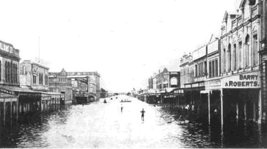
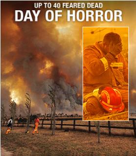
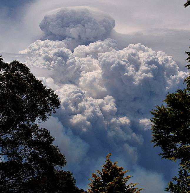