Posts Tagged ‘Grose Valley Fires 2006’
Thursday, May 16th, 2013
") Grose Valley inside the Blue Mountains National Park (World Heritage) Grose Valley inside the Blue Mountains National Park (World Heritage)
before the Parks Service let a fire burn through it out of control
in the Spring of 2006
[Photo by Ian D Smith]
.
20 Sep 2006: (2 months prior) Parks Service maximises hazard reduction burns
.
<<With warmer days just around the corner and continuing dry weather the Blue Mountains Region National Parks and Wildlife Service (Parks Service) is again undertaking rigorous preparation for the coming fire season.
“Every year around this time the Parks Service runs a number of fire preparedness days to ensure staff and fire-fighting equipment are fully prepared for the season ahead”, said Minister for the Environment Mr Bob Debus.
“Fire preparedness days require fire-fighting staff to check their personal protective equipment, inspect fire-fighting pumps and vehicles and ensure that communication equipment and procedures are in place and working before the fire season begins.”
Mr Debus said a number of exercises, including four-wheel drive and tanker driving, first aid scenarios, entrapment and burnovers, were also employed to re-familiarise staff with all apsects of fighting fires.
“Burnovers, where fire-fighters are trapped in a vehicle as fire passes over it, is one of the worst case scenarios a fire fighter can face so pre-season practice is critical to ensure that their response is second nature”, he said.
“Local fire-fighters have also undergone stringent fitness assessments to make sure they are prepared for the physical demands of fire-fighting – like being winched from a helicopter into remote areas with heavy equipment, to work longs hours under very hot and dry conditions wearing considerable layers of protective clothing”, Mr Debus explained.
Mr Debus said that fire preparedness and fitness assessment days worked in conjunction with a number of other initiatives as part of a year-long readiness campaign for the approaching summer.
.
“Over the past 12 months, NPWS officers have conducted more than 150 hazard reduction burns on national park land across NSW. Nineteen hazard reduction burns have been conducted in the Blue Mountains region covered more than 4500 hectares.” said Debus.
.
 Setting fire to bushland starts bushfires, strangely enough Setting fire to bushland starts bushfires, strangely enough
.
[Ed: These did nothing to prevent the Grose Fires. In fact it was one of the hazard reduction burns deliberately ignited by the Parks Service with the Hartley Vale Rural Fire Service along Hartley Vale Road that escaped over the Darling Causeway that was the main cause of the Grose Fire]
.
 Hartley Vale Road looking east about 1km west of the village of Hartley Vale.
Observe the right (south side) and the consistent blackened ground and blackened tree bases, clear evidence of ground level hazard reduction /backburning.
Compare this to the left unburnt side. It was this Hazard Reduction/Backburn on Sunday 12th November 2006 (or thereabouts) that escaped control and incinerated the treetops up slope and which crossed over the Darling Causeway into the Blue Mountains National Park and ultimately down into the Grose Valley on 23rd November 2006.
[Photo by Editor, 20070204, Photo © under ^Creative Commons] Hartley Vale Road looking east about 1km west of the village of Hartley Vale.
Observe the right (south side) and the consistent blackened ground and blackened tree bases, clear evidence of ground level hazard reduction /backburning.
Compare this to the left unburnt side. It was this Hazard Reduction/Backburn on Sunday 12th November 2006 (or thereabouts) that escaped control and incinerated the treetops up slope and which crossed over the Darling Causeway into the Blue Mountains National Park and ultimately down into the Grose Valley on 23rd November 2006.
[Photo by Editor, 20070204, Photo © under ^Creative Commons]
.
Mr Debus said that while fire fighting authorities are preparing themselves to be ready as possible for flare ups and major fires, home-owners in fire-prone areas of the Blue Mountains should also be readying themselves for the approaching season. [Ed: Famous last words]
“Now is the time to start cleaning gutters, ember-proof houses and sheds, prepare fire breaks and clear grass and fuel away from structures.” he said. [Ed: Such was the least of the bushfire risks when the Parks Service and RFS were actively and recklessly setting fire to bushland].
.
[Source: ‘Fire Crews Prepare’, 20060920, Blue Mountains Gazette, print]
.
Tags: Blue Mountains National Park, Blue Mountains World Heritage Area, bushfire causes, Darling Causeway, Escaped Controlled Burn, Grose Valley Fires 2006, Hartley Vale Road, hazard reduction, national parks, NPWS, prescribed burning
Posted in Blue Mountains (AU), Threats from Bushfire | No Comments »
Add this post to Del.icio.us - Digg
Saturday, July 7th, 2012
 The fire tragedy afflicted Australia’s legendary ‘Conservation Cradle’
A scorched Grose Valley from Evan’s Lookout, looking north up Govett’s Gorge
(Photo by Editor taken 20061209, free in public domain. Free Large Image) The fire tragedy afflicted Australia’s legendary ‘Conservation Cradle’
A scorched Grose Valley from Evan’s Lookout, looking north up Govett’s Gorge
(Photo by Editor taken 20061209, free in public domain. Free Large Image)
.
A heritage tragedy unfolds
.
A simple lighting stike ignited remote bushland in rugged terrain within the Blue Mountains National Park, over 5km north of the township of Blackheath on 20061113.
") Innocuously, the ignition started off on hilly Burra Korain Ridge,
It was far from settlement but during relatively calm weather and low temperature, so it was not suppressed but ‘monitored’
..then the wind picked up. Innocuously, the ignition started off on hilly Burra Korain Ridge,
It was far from settlement but during relatively calm weather and low temperature, so it was not suppressed but ‘monitored’
..then the wind picked up.
.
It and a second ignition west were allowed to continue burning for days until they eventually coalesced with compounded backburning into a firestorm some ten days later down in the Grose Valley. On 20061122, the prized Grose Valley and its iconic and precious Blue Gum Forest were incinerated under a pyrocumulus cloud of towering wood smoke that could be seen from the Sydney coast a hundred kilometres away. Some 14,070 hectares of National Park habitat was burnt. The tragedy did not so much as ‘strike‘ from the lighting itself, but as Blue Mountains residents we saw it ‘unfold‘ over many days and nights under the trusteeship of Bushfire Management.
.
..ten days later
 The pyrocumulus cloud of a screaming, dying Grose Valley precious to many, including wildlife The pyrocumulus cloud of a screaming, dying Grose Valley precious to many, including wildlife
The Grose Valley and its Blue Gum Forest and wildlife burning to death on 20061122
A greenhouse gas estimate was not taken.
.
Community shock, sadness and overwhelming sense of loss
.
How was this allowed to happen?
In the days that followed, many Blue Mountains residents and especially the many conservationists familiar with the Grose Valley and Blue Gum Forest over many years became deeply shocked at learning about the loss of this magnificent sacred preserved forest – its tall 300+ year old rare Blue Gums (Eucalytus deanii).
Without knowledge of personal accounts, one respects that the dramatic scenes of the smoke and fire inflicted personal trauma with many, given so many people’s long and established personal knowledge, affinity, love, awe and respect for..
‘The Blue Gum‘
.
The Habitat Advocate reaches out to these people (doesn’t matter the fact that years have passed) and we choose to express the view of a need to tell truths and to seek some sense of learned maturity from it all. For the Grose Valley contained many tracks, many walks and many special places if one knew where to look. Popes Glen and from Govetts Leap down under Bridal Veil following the popular Rodriguez Pass to Junction Rock then Acacia Flat and the Blue Gum Forest in the heart of the Grose. Many special places includes Beauchamp Falls, Docker Buttress, Pulpit Rock, Lockley Pylon, Anvil Rock lookout, Perrys Lookdown, Hanging Rock, Pierces Pass, Asgard Swamp, and the inaccessible Henson Glen and David Crevasse gorge.
To this editor, the return in 2007 to a previously sacred special, but incinerated Neates Glen was emptying in spirit. There was heartfelt shock and dismay by many local conservationists familiar with the iconic Blue Gum Forest who became deeply saddened by the tragedy.
 Neates Glen, as it was Neates Glen, as it was
But since incinerated, not by the wildife, but by deliberately lit ‘backburning’
.
Phone calls and emails were exchanged with many locals wanting to know the extent of the damage and whether ‘the Blue Gum‘ could recover. The original fire had been fanned westward from Burra Korain Head spotting along the Blackheath Walls escarpment, but then decended and burnt through Perrys Lookdown, Docker Buttress and down and through the Blue Gum. Deliberately lit backburns had descended and burnt out Pierces Pass (Hungerfords Track) through rainforest into the Grose and everyone had seen the pyrocumulus mushroom cloud towering 6000 feet above the Grose on the 22nd.
There was an immense sense of loss. The relatively small Blue Gum Forest, perhaps just several hectares, was unique by its ecological location, by its grand age and by its irreplaceability. The sense of loss was perhaps more pronounced amongst the more mature conservationists, now lesser in number, who knew its original saviours of the 1930s – Alan Rigby, Myles Dunphy and other dedicated bushwalkers who had championed to save it from logging 81 years ago.
 The conservation heritage of The Blue Gum Forest dates back to Australia’s earliest conservation campaign from 1931
For this reason ‘The Blue Gum Forest’ has been passionately respected as
Australia’s ‘Cradle of Conservation’ The conservation heritage of The Blue Gum Forest dates back to Australia’s earliest conservation campaign from 1931
For this reason ‘The Blue Gum Forest’ has been passionately respected as
Australia’s ‘Cradle of Conservation’
.
The region is home to threatened or rare species of conservation significance living within the rugged gorges and tablelands, like the spotted-tailed quoll, the koala, the yellow-bellied glider, the long-nosed potoroo, the green and golden bell frog and the Blue Mountains water skink. Many would have perished in the inferno, unable to escape. The Grose is a very quiet and sterile place now, with only birds. But to the firefighters, these were not human lives or property.
.
Deafening silence from the ‘Firies’ naturally attracted community enquiry and suspicion
.
The day after the firestorm that enveloped the Grose Valley, the wind subsided and from 20061123 through to the final mopping up date of 20061203, the 2006 Grose Bushfire and its many ember spotfires came under bushfire management control and were ultimately extinguished or else considered to be ‘benign‘.
It is important to note that during the entire bushfire event from 20061113 through to 20061203, only NSW Rural Fire Service ‘Major Fire Updates’ on its website and headline journalism appeared in the local Blue Mountains Gazette newspaper. Initially, the community, conservationists and ‘firies’ were respectfully passive. In the immediate aftermath of the fire from 20061204 through to the weekly issue of the Blue Mountains Gazette on 20061129, the local community, conservationists and ‘firies’ were letter silent in the paper. It was a combination of shock, preoccupation with the emergency and respectful anticipation of communication from the bushfire authorities.
One can assume here that given the scale of the tragedy, many in the Blue Mountains community were respectfully patient in anticipation of an assured announcement from Bushfire Management or some communication process. But none eventuated.
.
Injustice
.
The following weekly issue of the Gazette was published on 20061129, but no communication from Bushfire Management. Only dismissive bureaucratic statements came from Parks and Wildlife’s Regional Director Geoff Luscombe with a tone suggesting minimal damage and business-as-usual.
This was the article:

6th Dec: ‘Park managers take stock as smoke clears’
[Source: ‘Park managers take stock as smoke clears’, by journalist Jacqui Knox, Blue Mountains Gazette, 20061206, ^http://www.bluemountainsgazette.com.au/news/local/news/general/park-managers-take-stock-as-smoke-clears/487936.aspx?storypage=0]
 Ed: This RFS propaganda photo was included in the media article.
Govetts Leap Track (shown here) was deliberately lit by Bushfire Management Ed: This RFS propaganda photo was included in the media article.
Govetts Leap Track (shown here) was deliberately lit by Bushfire Management
.
‘Hundreds of fire-fighters are celebrating a return to normality this week after cooler weather and an intense two-week campaign by volunteers and professionals brought a fire in the Grose Valley under control.
According to the Rural Fire Service this good weather, combined with a thorough mop-up operation and ongoing infra-red monitoring, means flare-ups are unlikely. However the 15,000 hectare burnt area – including the iconic Blue Gum Forest – is likely to remain closed for the “foreseeable future” due to safety concerns and regeneration.
Geoff Luscombe, regional manager of the National Parks and Wildlife Service (NPWS), said the fact that only part of the Grose Valley burnt meant many animals had been able to seek refuge.
“Many of the Australian plants and animal species have learnt not only to survive fire but to exploit it,” he said. However he confirmed fears that the fire had burnt Blue Gum Forest – a Mecca for bushwalkers and conservationists in the heart of the Grose Valley.
“Blue gums aren’t a particularly fire-tolerant species,” he said. “Fire last burnt through Blue Gum in 1994. The effects of this fire we don’t know yet and we may not know for many months to come.”
A botanist has been sent to inspect the area and there could be ongoing monitoring. Mr Luscombe did not wish to comment on how the fire was handled due to a lengthy absence, but Inspector Jack Tolhurst from the Blue Mountains District Rural Fire Service has warded off any potential criticism.
“I think at the moment we should be looking at the positive,” said Inspector Tolhurst. “The fire is contained . . . It’s been a very long campaign but at the end of the day we haven’t lost any property or lives and half the Grose Valley at least remains intact.”
A fire that broke out near Zig-Zag Railway last week has also been contained. [Ed. According to inside reports, Zig Zag Railway Station was accidentally firebombed by an aerial helicopter attempting backburning].
“We’ve had a lot of help from a wide range of people. We’ve had wonderful support from the community . . . it was a wonderful effort from everyone.”
Meanwhile the hard work has only just begun for another group of dedicated volunteers. Blue Mountains WIRES are expecting to rescue a number of fire-affected native animals in coming months as they wander into residential areas for food and water.
“The arboreal animals – possums and gliders – they come to grief,” said chairperson Greg Keightly. “Birds suffer heat stress and smoke inhalation. They’re going to be flying around bewildered.”
He said residents who see native wildlife in urban areas should keep pets inside, provide water off the ground in a place safe from predators, and avoid the temptation to feed wildlife.
“Things come up for months after fires,” said Mr Keightley. “Do ring us (4754-2946) if you thing something is injured or doing it tough,” he said.
The national park south of the Great Western Highway, and the lookout at Govetts Leap, are open to visitors. For information on closures call 4787-8877 or visit www.nationalparks.nsw.gov.au’
.
.
Mismanagement?
.
So the silence from the firies, from Bushfire Management and from the New South Wales Government ultimately responsible and accountable, was deafening. It was as if the entire Firie fraternity had gone to ground in a code of silence behind closed doors.
So naturally the community response was that something smelt fishy. This communication intransigence was a public relations blunder by Bushfire Management, to its detriment.
Then filtered out accounts of crazy operational mismanagement during the bushfire and of bush arson by the firies behind the roadblocks beyond the public gaze.

- Rumours circulated that the initial ignition had been left for burn in the critical first few days of 13th November and 14th November up on Burra Korrain Ridge because it wasn’t right next to a road so that fire trucks could get to it. The fire had even been abandonned. Then the wind picked up and it spread. Airborne firefighting was not called in until a Section 44 incident declaration was effected on 15th November.
- A second fire nearby to the west near Hartley Vale, purported also lit by dry lightning on 14th Nov, had attracted broadscale backburning from the Hartley Vale Road. But the backburn got out of control, ripped up the valley fanned by winds and crossed over the Darling Causeway on to the Blackheath Escarpment and the Upper Grose to join up with the first blaze. The onground evidence shows that this was a hazard reduction burn starting from alongside the Hartley Vale Road just east of the village of Hartley Vale.
- Then came the account of senior bushfire management at the Rural Fire Service headquarters at Homebush ordering a ‘headburning’ a new 10km fire front along the south of the Bells Line of Road into the Grose Valley. Perhaps the NSW Government had stepped in demanding action. Perhaps RFS headquarters response was a series of overreactions, albeit too late and to be seen to be now ‘acting’ was only compounding the fire risk to the Grose . Apparently, the RFS Commissioner had even touted imposing a massive defacto hazard reduction north of the Bells Line of Road right though the vast wilderness of the Wollemi National Park, to somehow head off another fire on 20th November some 80km away north of Wiseman’s Ferry, but that strategy was rejected in a heated operational debate. [“The Wollemi National Park is part of the World Heritage Area and covers 488,620 hectares. Important values of the park include the spectacular wild and rugged scenery, its geological heritage values, its diversity of natural environments, the occurrence of many threatened or restricted native plant and animal species including the Wollemi pine and the broad-headed snake, significant plant communities, the presence of a range of important Aboriginal sites and the park’s historic places which are recognised for their regional and national significance.” – Wollemi NP Plan of Management, April 2001]
- Even the Zig Zag tourist railway station was apparently accidently firebombed by an overzealous airborne firefighter starting backburning en mass
- Then came the account of Blackheath residents who had their houses subjected to the risk of a deliberately lit backburn during the course of the bushfire. Despite the out of control wildfire being many miles to the north west of Blackheath, a broadscale backburn (some say is was really a ‘defacto hazard reduction‘) was lit along the fire trail below the electricity transmission line near Govetts Leap lookout. But it got out of control briefly and threatened to burn houses in Connaught Road. Indeed the entire Blackheath Escarpment fire from Hat Hill Road south through Govetts Leap Lookout and Ebans Head was started deliberately as a ‘strategic’ backburn.
 Blackheath Escarpment completely burnt (top) for hectares, looking south from Hat Hill Road
(Photo by editor 20061209, free in public domain, click image to enlarge) Blackheath Escarpment completely burnt (top) for hectares, looking south from Hat Hill Road
(Photo by editor 20061209, free in public domain, click image to enlarge)
.
 The rural property east of Hartley Vale where on 20070207 there was clear evidence of hazard reduction (HR)
commencing only from the south side Hartley Vale Road, opposite.
Eucalypts were burned only at the base, but further up the hill the tree crowns had been burned.
The HR had quickly got out of control and then crossed over the Darling Causeway.
(Photo by editor 20070207, free in public domain, click image to enlarge) The rural property east of Hartley Vale where on 20070207 there was clear evidence of hazard reduction (HR)
commencing only from the south side Hartley Vale Road, opposite.
Eucalypts were burned only at the base, but further up the hill the tree crowns had been burned.
The HR had quickly got out of control and then crossed over the Darling Causeway.
(Photo by editor 20070207, free in public domain, click image to enlarge)
.
Once two weeks had passed since the dramatic firestorm and with only silence emanating from Bushfire Management and the NSW Government, local people had had enough and they wanted answers.
Some 143 local yet disparate conservationists via ‘jungle drums’ met up, discussed the issue, united informally and agreed to go public. They informally formed the ‘Grose Fire Group‘ and contributed to a fighting fund some $1700 odd and became vocal. Two weeks after the Grose Valley Firestorm the Grose Fire Group managed a full page open letter in the local Blue Mountains Gazette on 20061206 on page 13. It was directed to the ultimate authority responsible and accountable for the Grose Fire Tragedy, the NSW Government. The Premier at the time was Labor’s Morris Iemma MP. The NSW Member for the NSW Seat of Blue Mountains as well as NSW Minister for Environment at the time was Bob Debus MP.
Those who valued the Blue Gum Forest challenged those responsible for its protection. The tragedy certainly stirred and polarised the Blue Mountains community. Conservationists naturally wanted answers, an enquiry, a review of bushfire prevention and management from:
- NSW National Parks and Wildlife Service under the direction of Regional Director Geoff Luscombe
- NSW Rural Fire Service under the direction of Commissioner Phil Koperberg
- Blue Mountains Bushfire Management Committee aligned with Blue Mountains City Council and chaired by Councillor Chris Van Der Kley.
.
‘Grose Valley Fire – World Heritage takes a hit’
“The Blue Gum Forest, birth-place of the modern conservation movement, was badly damaged by the Grose fire on Wednesday the 22nd of November. If this precious forest was a row of houses, then there would automatically be a major investigation into how the fire was fought. The fact that this major loss of our natural heritage is only now becoming known is testimony to the prevailing attitudes of those controlled the media spin during this recent fire event,” said Keith Muir director of the Colong Foundation for Wilderness.
“Until today the overall perception from the media was that this fire was a good one. No houses or lives lost”, Mr Muir said.
“There where no media updates on the struggle to save Blue Gum. No the reports of success in saving fire sensitive rare plants and rainforests along the escarpment edge. All the media reports spoke of bushland burnt; not on the success of any strategy to minimise the impact on the World Heritage listed national park, while saving lives and property”, he said.
“The Blue Mountains National Park Fire Management Strategy 2004 sets out all the necessary actions to protect the natural environment, as well as life and property. Yet for some reason it appears at this stage that the fire was not fought according to that agreed Strategy, as far as its provisions on natural heritage were concerned”, said Mr Muir.
“Increased fire is a major threat to World Heritage values of the Greater Blue Mountains national parks. Unless we develop and implement better strategies to defend the bush, as well as lives and property, then climate change will make this threat much worse,” Mr Muir said.
“The fire management strategies and techniques undertaken during the fire need to be re-examined to ensure the diversity of the Blue Mountains forests is protected into the future,” he said.
“Future fire management requires the feedback that only an inquiry into the Grose Valley Fire can achieve. Such an inquiry should not be taken as a criticism of those involved in fighting fire. It is an opportunity to ensure that everyone stays on fully board with future efforts to minimise fire damages,” Mr Muir said.’
[Source: Colong Foundation for Wilderness, ^http://www.colongwilderness.org.au/media-releases/2006/12/grose-valley-fire-%E2%80%93-world-heritage-takes-hit]. The magnificent rich carpeted Gross Valley, as it was
(compare with the lead photo at the start of this article, click image to enlarge) The magnificent rich carpeted Gross Valley, as it was
(compare with the lead photo at the start of this article, click image to enlarge)
.
What exacerbated the conflict was not some much that the bushfire had got out of control and had raged through the precious Grose Valley per se, but it was more the defensive, aloof reaction by ‘Firies’ which escalated into a barrage of defensive and vocal acrimony against any form of criticism of the firefighters.
In the face of such palatable denial by the Firies,of any accountability the initial shock and sadness within the local community within days quickly manifested into outrage and anger, and even to blame and accusations.
 
Most conservationists however felt a right to question and seek specific answers from Bushfire Management about the Grose Fires, for lessons to be learned, for fundamental changes to be made to bushfire management policy, bushfire fighting resourcing and practices, all simply so that such a tragedy should not be repeated.
But the key problem was that the ‘Firies‘ adopted an ‘in denial’ approach to a community suffering loss. Many Firies denied that they had done anything wrong and rejected any criticism by conservationists. Some Firies vented their anger in the local media attacking anyone who dared criticise. Clearly, Bushfiore Management’s debriefing and review of the bushfire in its immediate aftermath was poorly managed.
Underlying the conflict was the Firies urban fire fighting mandate to ‘protect lives and property” – that is human ones, not forests, not wildlife. Whereas what emerged with many in the Blue Mountains community was the implicit expectation that the World Heritage Area is an important natural asset to be protected, including from devastating bushfire.
") The Grose Valley
Greater Blue Mountains World Heritage Area The Grose Valley
Greater Blue Mountains World Heritage Area
.
Hence, it was a conflict between differing cultural value systems. It was about recognition of the value of the natural assets of the Blue Gum Forest and the Grose Valley within the Bue Mountains National Park within the Greater Blue Mountains World Heritage Area.
 The iconic Blue Gum Forest
(Acacia Flat, before the pyrocumulus firestorm of 22nd November 2006) The iconic Blue Gum Forest
(Acacia Flat, before the pyrocumulus firestorm of 22nd November 2006)
.
") The iconic Blue Gum Forest
(The aftermath) The iconic Blue Gum Forest
(The aftermath)
.
20 Sep: (2 months prior)…‘Fire crews prepare’
[Source: ‘Fire crews prepare’, Blue Mountains Gazette, 20060926]
.
‘With warmer days just around the corner and continuing dry weather the Blue Mountains Region National Parks and Wildlife Service (NPWS) is again undertaking rigorous preparation for the coming fire season.
“Every year around this time the NPWS run a number of fire preparedness days to ensure staff and fire-fighting equipment are fully prepared for the season ahead,” said Minister for Environment Mr Bob Debus.
 NSW Labor Minister for Environment
Mr Bob Debus MP NSW Labor Minister for Environment
Mr Bob Debus MP
.
“Fire preparedness days require fire-fighting staff to check their personal protective equipment, inspect fire-fighting pumps and vehicles and ensure that communication equipment and procedures are in place and working before the fire season begins.”
Mr Debus said a number of exercises, including four-wheel drive and tanker driving, first aid scenarios, entrapment and burnovers, were also employed to re-familiarise staff with all aspects of fighting fires.
“Burnovers, where fire-fighters are trapped in a vehicle as fire passes over it, is one of the worst case scenarios a fire-fighter can face so pre-season practice is critical to ensure that their response is second nature”, he said. “Local fire-fighters have also undergone stringent fitness assessments to make sure they are prepared for the physical demands of fire-fighting – like being winched from a helicopter into remote areas with heavy equipment, to work long hours under very hot and dry conditions wearing considerable layers of protective clothing”, Mr Debus explained.
Mr Debus said that fire preparedness and fitness assessment days worked in conjunction with a number of other initiatives as part of a year-long readiness campaign for the approaching summer.
“Over the past 12 months, NPWS officers have conducted more than 150 hazard reduction burns on national park land across NSW.”
.
“Nineteen hazard reduction burns have been conducted in the Blue Mountains region covering nmore than 4500 ha” ~Bob Debus MP
.
Mr Debus said that while fire-fighting authorities are preparing themselves to be as ready as possible for flare ups and major fires, home-owners in fire prone areas of teh Blue Mountains should also be readying themselves for the approaching season. “Now is the time to start cleaning gutters, ember proof houses and sheds, prepare fire breaks and clear grass and fuel away from structures”, he said.’
.
20 Nov: ‘Bushfires rage closer’
[Source: ‘Bushfires rage closer’, by Dylan Welch and Edmund Tadros, Sydney Morning Herald (with Les Kennedy and AAP), 20061120, ^http://www.smh.com.au/articles/2006/11/21/1163871368365.html?from=top5]
.
Wisemans Ferry:
‘Residents in the historic Hawkesbury River village of St Albans prepared for the worst as raging bushfires neared. Their predicament came with a fresh fire outbreak in a remote corner of Wollemi National Park, 73 kilometres north of Windsor about 2pm. A Rural Fire Service spokesman said the blaze had destroyed 450 hectares by 3pm. It was being fanned by a string of north-westerly winds and had jumped Putty Road, causing its closure to traffic between Singeleton and Richmond. Winds of up to 80kmh forecast for the early hours of tomorrow are expected to drive the fire towards St Albans. About 45 Rural Fire Service volunteers with 10 tankers have been deployed to protect the small community as residents tried to safeguard their homes from floating embers. At least two helicopters were in the air to assist the operation.
") Wildfire, spot fires and back burning across the Blackheath plateau
(Photo by Rural Fire Service) Wildfire, spot fires and back burning across the Blackheath plateau
(Photo by Rural Fire Service)
.
Blue Mountains:
‘Meanwhile a spokesman for the RFS, Andrew Shade, told (the Sydney Morning Herald) firefighters were waiting to see if changing winds would affect the Blue Mountains fires, which jumped containment lines overnight. “The fire is across about 7000 hectares; we’ve got 18 aircraft working the fire, including two sky cranes, [and] 400 personnel at the fire on about 60 trucks.”
..Other fires continue to burn across the state, with a number of fires across 7000 hectares in the Hunter Valley burning in remote and inaccessible areas. Two other fires, near Forbes and Bathurst respectively, are both contained but the RFS has expressed concerns over the weather and its ability to cause a change in the nature of the the two blazes. Firefighters set up a containment line to protect the outskirts of Blackheath in the Blue Mountains.
Rural Fire Service Commissioner Phil Koperberg said today winds gusting up to 80kmh were predicted for about 3am tomorrow – a time when firefighting planes are unable to fly. At a news conference in Katoomba, Mr Koperberg described the present threat to Blue Mountain towns as “fairly serious … not grave”. However, he urged residents to clean fuel away from their homes as a precaution. This afternoon the most intense efforts were along a containment line at the northern end of Hat Hill Road at Anvil Rock. If that line was breached, the outskirts of Blackheath could be under threat, he said. Firefighters expected wind changes in the area between 4pm and 6pm today. The Bells Line of Road remains closed and the Blue Mountains National Park will remain closed until further notice.
The Great Western Highway and the Darling Causeway were open but drivers were advised to proceed with caution, with smoke likely to affect the roads. A total fire ban now applies in all but the north-east corner of the state as temperatures in the high 30s (Celsius), the strong winds and low humidity combine to produce potentially savage conditions…’
.
22 Nov: ‘Firefighters standing strong’
[Source: Firefighters Standng Strong’, by Shane Desiatnik, Blue Mountains Gazette, Wednesday, 20061122, pages 1 and 3,^ http://www.bluemountainsgazette.com.au/news/local/news/general/standing-strong/439486.aspx?storypage=0, Ed: Note this is quoted from the paper edition, which was different to the online edition]
.
‘Thick smoke continues to drift across the Blue Mountains as the largest firefighting and backburning operation in the region since January 2003 enters its second week.
Hundreds of RFS volunteers, NSW Fire Brigades, SES and NPWS personnel, a number of remote firefighting units and 16 waterbombing aircraft are enlisted under a Section 44 declaration with a mission of containing and then attacking bushfires burning in the Grose Valley. The fires are believed to have been ignited by lightning on Monday, November 13 and at the time of going to press had burnt out 3800 hectares of bushland and private parkland in the valley below Blackheath, Mt Victoria, Bell and Mt Tomah.
No homes were under threat on Tuesday morning, but the RFS almost doubled its resources in the Blue Mountains on Monday night following unfavourable weather conditions.
The NSW FireBrigades also deployed extra fire engines and firefighters ot the Blue Mountains on Tuesday.
The large Blue Mountains bushfire broke its containment lines at Anvil Rock about 11 pm on Monday. Earlier, a comprehensive backburning operation involving 300 firefighters commenced on Saturday night between Blackheath and Mt Victoria to protect the townships if conditions worsened. A second phase began along Bells Line of Road between the Darling Causeway and Mt Tomah on Monday morning, continuing to Pierces Pass picnic area to the south.
The backburning activities can cause heavy smoke to linger in residential areas and residents are advised to close windows and doors. An emergency operations centre is active in Katoomba under the control of Local Emergency Operating Controller and Blue Mountains Police Local Area Commander Patrick Paroz, with the RFS as the lead combat agency.
Blue Mountains RFS community safety officer Eric Berry said remote area firefighting units will continue to attack the fire at the fringe and a fleet of 16 aircraft based in Medlow Bath airfield will operate to contain the fire.
“14 medium to heavy capacity helicopters have been operating 24/7 since last Tuesday [Ed: This contradicts the official RFS Section 44 Incident Controllers Report – Wednesday 15th not Tuesday 14th] and we now have three air crane helicopters on the job,” Inspector Eric Berry said. “This is a massive operation, certainly the biggest in the last three years. “It involves up to 300 RFS, NSW Fire Brigades, NPWS, police and SES personnel and volunteers at any one time, sourced from all over eastern NSW as well as every Blue Mountains RFS brigade. “Then there are the support services chipping in like the Salvation Army, who have been supplying breakfast at 5.30 am on a daily basis for the firefighters.”
Inspector Berry said RFS community information meetings last weekend were very successful in seven upper Mountains towns. “More than 200 residents attended one of the meetings held at Blackheath Golf Club, giving us an opportunity to explain what is going on in plain English. “More meetings may occur, but in the meantime residents should phone the RFS information line for updates. “We are getting nearly 6000 hits on our website per day and are updating the site at regular intervals.”
The Gazette visited the Medlow Bath Airfield last Friday, which continues to be a hive of activity. Six helicopters, including a giant sky crane chopper, took off and landed several times inside an hour, collecting water loads from nearby dams and dropping them into and ahead of the flames. Kev Adams, an RFS volunteer from Gloucester, described the conditions the pilots had to deal with early last week as wild.
“I came down from Gloucester last Wednesday and we went up in a chopper and the wind was blowing at about 41 knots. “We hit a pocket of turbulence and I hit my head on the ceiling even though I was strapped in, that’s how wild the wind was. “Hopefully we’ll be able to head home soon.”
Inspector Eric Berry said good progress has been made, but the weather ahead could test the containment lines.’
.
Ed: Additional reporting in the online version of this article:
‘Severe weather is expected for the Blue Mountains this afternoon between 2.00pm and 5.00pm. A Total Fire Ban has been declared for a number of areas across the state today, including the Blue Mountains. Temperatures in the Blue Mountains are expected to reach 31 degrees with west-north-west winds gusting up to 45km/h.
Fire behaviour yesterday was subdued due to mild conditions and the main front extinguishing in very low fuel levels. Advantage was taken of these conditions to consolidate containment lines. The fire has now been burning for fourteen days and burnt nearly 15,000 hectares.
The amount of smoke is likely to increase today. Aircraft and ground crews will be actively patrolling the fire for reactivation of fire edges. Infrared hot spot technology is being used in an attempt to identify stumps and roots that are still smouldering near the edges. Crews can then locate the hotspots and extinguish them.
The Bells Line of Road between the Darling Causeway and Mount Tomah has been re-opened but may be closed intermittently. Mount Banks and Pierces Pass trails and tracks are closed to the public. Residents in the Blue Mountains and Hawkesbury should remain vigilant.’
.
22 Nov: ‘Bushfire breaks lines again’
[Source: ‘Bushfire breaks lines again’, 20061122, Sydney Morning Herald, (AAP), ^http://www.smh.com.au/news/national/bushfire-breaks-lines-again/2006/11/22/1163871435049.html]
.
") Volunteers back burn along Bells Line of Road as smoke from the fire front can be seen overhead
(Photo by Wade Laube) Volunteers back burn along Bells Line of Road as smoke from the fire front can be seen overhead
(Photo by Wade Laube)
.
‘A major bushfire burning out of control in the Blue Mountains again broke containment lines overnight ahead of forecast rugged day for fire fighters. Two separate blazes have blackened more than 8,000 hectares of the Blue Mountains, west of Sydney, with the larger of the two burning on a massive front about four kilometres north of the township of Blackheath.
Wind gusts of up to 70kph are forecast to push through that area, around Grose Valley, about 4am (AEDT) today. Blustery conditions expected for most of the day with temperatures in the low 30s (Celsius).
Rural Fire Service (RFS) Commissioner Phil Koperberg has said the towns of Mt Tomah and Mt Wilson would be vulnerable to a wind change. An RFS spokesman said crews had been working on a 35km containment line through the night but the bigger fire had now broken its eastern containment lines. He said crews were prepared for the “tricky” conditions expected early today, with wind gusts expected to pick up as the day gets warmer. Waterbombing aircraft cannot take off until first light but no property is currently under direct threat.
Meanwhile, a new bushfire burning in the Wiseman’s Ferry area is not posing any immediate threat to the village of St Albans, 90km north-west of Sydney. However, the RFS spokesman said that could also change depending on today’s winds. A total fire ban has been declared for much of the state today, including the Greater Sydney and Greater Hunter areas, the Illawarra and far south coast, southern and central ranges, the upper and lower central west plains and the eastern Riverina.’
.
23 Nov: “Massive fire back-burn effort’
[Source: ‘Massive fire back-burn effort’, Mx (free Sydney commuter newspaper), by Matt Sun, 20061123, page 1]
.
‘Hundreds of firefighters are today hoping a massive 30km containment line will stop the Blue Mountains bushfire in its tracks. [Ed: Bit late, this is the day after that pyrocumulus firestorm]
About 200 Rural Fire Service and NSW Fire Brigade firefighters worked overnight on a back-burn between Blackheath and Wentworth Falls. Firefighters were on standby until temperatures dropped and winds died. They were sent in to light the back-burn as soon as conditions calmed down. Crews spent this morning back burning on the Bells Line of Road and hoping to create containment lines near the village of (Mt) Tomah if winds subside.
The RFS said 400 firefighters started work on the blaze this morning. The weather bureau forecast a maximum temperature of 27C, 45kph gusting winds and 17% humidity this afternoon.
Two fires, both ignited by lightning 10 days ago, joined up this week and have now destroyed 14,500 ha. An RFS spokeswoman said the fire was burning 2.5 km south of Mt Tomah and 7km north of Wentworth Falls…Crews and 15 aircraft will remain on standby to extinguish any spot fires that pass over teh containment line. Fire-bombing helicopters Elvis and Shania were likely to be sent to other fires burning across NSW.
The RFS today said Blue Mountains townships were not in immediate danger but should remain alert. But experts warned the extreme weather conditions would return next week, with the mercury reaching the mid 30s.’
.
29 Nov: “Firefighters gain upper hand”
[Source: ‘Firefighters gain upper hand’, by Shane Desiatnik, 20061129, ^http://www.bluemountainsgazette.com.au/news/local/news/general/firefighters-gain-upper-hand/348587.aspx]
 RFS propaganda photo for a sympathetic media
These two RFS firies are at the Evan’s Lookout backburn that was deliberatly lit by the RFS
(Photo by Blue Mountains Gazette journalist, Shane Desiatnik, 20061124) RFS propaganda photo for a sympathetic media
These two RFS firies are at the Evan’s Lookout backburn that was deliberatly lit by the RFS
(Photo by Blue Mountains Gazette journalist, Shane Desiatnik, 20061124)
.
The above photo shot taken by the local Blue Mountains Gazette newspaper’s lead journalist, achieved front page on 20061129. The caption read: “Assessing the aftermath: Medlow Bath RFS crew member Noah Taylor and team leader Michael Anderson near Evans Lookout last Friday.”
This same photo was re-used by the Blue Mountains Gazette a year later on 20071024 (page 7) to support an article by the Rural Fire Service incident controller in charge of co-ordinating the fire-fighting of the 2006 Grose Fire, Mal Cronstedt, who responded to an article in the paper on this subject by The Habitat Advocate dated 20071010.
.
‘Hundreds of weary but determined firefighters are steadily gaining the upper hand over a Grose Valley bushfire that has burned about 15,000 hectares since November 13.
Daylight waterbombing by a fleet of choppers based at Medlow Bath airfield, increasing access by remote area firefighting units, successful backburns along the northern and southern escarpments and milder than predicted weather conditions since Saturday have limited the spread of the fire.
At the time of going to press, 130 RFS, NSW Fire Brigades and NPWS firefighters and nine helicopters were conducting backburns, mopping up buffer zones and cutting in access trails to the fire’s fringes. The active front of the fire was within containment lines yesterday morning, allowing the Bells Line of Road and Mt Tomah Botanical Gardens to re-open.
A small fire that started at Mitchells Lookout in Mt Victoria on November 23 is extinguished and investigations are continuing into its cause.
Blue Mountains RFS is warning residents to remain vigilant by continuing to prepare their homes for fire if conditions worsen and to immediately report any suspicious activity to CrimeStoppers by calling 1800-333-000.
The milder conditions are a welcome relief from the heat and 100 km/h wind gusts that put residents of Hazelbrook, Linden, Faulconbridge and Winmalee on high alert last Wednesday afternoon.
An explosion within the fire, which witnesses described as causing a mushroom-like cloud to develop, ignited spotfires four kilometres north of Lake Woodford and five kilometres north of Hazelbrook. Many residents headed home early from work to clear gutters and roofs and two Winmalee schools opted to close for 24 hours as a precaution. Eighteen water-bombing aircraft attacked the spotfires, extinguishing one within hours and the second by Thursday evening.
For daily fire updates and advice, go to www.bluemountains.rfs.nsw.gov.au, phone a dedicated 24-hour hotline manned by local volunteers on 1800-264-525 or visit your local RFS station, staffed by volunteer station officers.
“These people are the unsung heroes of the RFS,” Blue Mountains RFS public liaison and education officer Paul McGrath said.
.
Overwhelming grief shunned by government hush, galvanised an immense sense of environmental injustice :
It was time to challenge (with due civility) the unaccountable bastards in authority…the NSW Government:
") An extract of a full page letter in the Blue Mountains Gazette 20061206 on page 13 An extract of a full page letter in the Blue Mountains Gazette 20061206 on page 13
It was commissioned by 143 concerned Blue Mountains residents
It was addressed not to the ‘firies’, but to the NSW Government.
.
") Pulpit Rock on the left of the Grose Valley, before the firestorm
It is easy to see why the Blue Mountains, with their Eucalytus tree oil suspended in the atmosphere, get their famous name.
(Photo by Chris Ellis) Pulpit Rock on the left of the Grose Valley, before the firestorm
It is easy to see why the Blue Mountains, with their Eucalytus tree oil suspended in the atmosphere, get their famous name.
(Photo by Chris Ellis)
.
Tags: 2006 Grose Fires, Blackheath Escarpment, Blue Gum Forest, Blue Mountains, Blue Mountains Council, Blue Mountains Gazette, Blue Mountains National Park, Blue Mountains World Heritage Area, Bob Debus MP, Burra Korain Ridge, bushfire management, Cradle of Conservation, defacto hazard reduction, Firies, Geoff Luscombe, Grose Fire Group, Grose Valley Fires 2006, Gross Valley, Hartley Vale, hazard reduction, Neates Glen, NPWS, NSW Government, NSW National Parks and Wildlife Service, Premier Morris Iemma, pyrocumulus cloud, RFS, RFS Commissioner Phil Koperberg, RFS Section 44 Report, Rural Fire Service
Posted in Blue Mountains (AU), Threats from Bushfire | No Comments »
Add this post to Del.icio.us - Digg
Friday, March 16th, 2012
In November 2006, two separate bushfires that were allowed to burn out of control for a week as well extensive deliberate backburning, ended up causing some 14,070 hectares of the Blue Mountains National Park to be burnt.
This wiped out a significant area of the Grose Valley and burnt through the iconic Blue Gum Forest in the upper Blue Mountains of the Greater Blue Mountains World Heritage Area (GBMWHA).
In the mind of Rural Fire Service (RFS) and the National Parks and Wildlife Service of New South Wales (NPWS), National Parks and World Heritage do not figure as a natural asset worth protecting from bushfire, but rather as an expendable liability, a ‘fuel’ hazard, when it comes to bushfire fighting.
.
This massive firestorm has since been branded the ‘Grose Valley Fires of 2006‘.
To learn more about the background to this bushfire read article: >’2006 Grose Valley Fires – any lessons learnt?‘
 Pyrocumulous ‘carbon’ smoke cloud
above the firestorm engulfing the Grose Valley 20061123 Pyrocumulous ‘carbon’ smoke cloud
above the firestorm engulfing the Grose Valley 20061123
.
About a month after the fire, on Tuesday 19th December 2006 there was apparently an ‘Inter-Agency Review‘ which took place at Katoomba behind closed doors by members of bushfire management and operating personnel involved in the fire fighting. Despite requests by this Editor, no minutes or reports of that meeting were ever forthcoming. The meeting was internal and secret.
Immediate local community outrage called for explanations and accountability from the Rural Fire Service (RFS) (the government agency responsible for rural fire fighting throughout the State of New South Wales) in charge of fighting the bushfires and for a review of bushfire management practices with a view to ensuring that the highly valued Greater Blue Mountains World Heritage Area and iconic Blue Gum Forest in particular is protected from bushfire in future. Many members of the local community called for an independent and public review or enquiry.
One local resident wrote in the local Blue Mountains Gazette newspaper:
.
‘Questioning the RFS’
by Dr Jackie Janosi, Katoomba, 20061204
.
‘To start, this is directed at the upper levels of the RFS and not to the wonderful local volunteers – many of whom are loved and respected friends and colleagues.
To stop the loud community Chinese whispers and restore faith with the local community, could someone please respond with factual answers about the recent Grose Valley fire that are not reinterpreted with a political spin.
- How many hectares of bush was burnt by the Grose Valley wildfire and how many was burnt by the RFS mitigation efforts?
- How many houses and lives were at risk from the wildfire as versus to the RFS fire?
- How many millions of dollars were spent on water bombing the RFS fire?
- How many litres of precious water were used to put out the RFS fire?
- Is it true that soil-holding rainforest was burnt and that the real reason for the Mt Tomah road block was erosion from the RFS removal of this natural fire-break?
- Was local advice and expertise sought and followed or simply ignored?
- If mistakes were made, what measures will be taken to ensure that this does not happen again?
.
I sincerely hope that if mistakes were made then the upper levels of the RFS can show the humility and good future planning that is now required to restore it’s good reputation. I hope that the RFS can show that it is still a community group that cares for the safety of our Blue Mountains residents, is able to respect and respond to our very special local environment and is able to make sound decisions about valuable resources.’
.
Ed: Her questions were never answered. With the RFS rejecting calls for a public or independent review, there was a general sense amongst many in the local community of a cover up and of gross incompetence going unaccounted for.
") One of two ignitions that got out of control
– this one in ‘Lawson’s Long Alley‘, north of Mount Victoria
(Photo: Eric Berry, Rural Fire Service, 2006) One of two ignitions that got out of control
– this one in ‘Lawson’s Long Alley‘, north of Mount Victoria
(Photo: Eric Berry, Rural Fire Service, 2006)
A week later, a front page article was published in the Sydney Morning Herald 20061211 by journalist Gregg Borschmann entitled ‘The ghosts of an enchanted forest demand answers‘ ^http://www.smh.com.au/news/national/the-ghosts-of-an-enchanted-forest-demand-answers/2006/12/10/1165685553891.html [>Read article]. A second in depth article by Borschmann was also run on page 10 ‘The burning question‘, ^http://www.smh.com.au/news/national/the-burning-question/2006/12/10/1165685553945.html?page=fullpage#contentSwap1, [>Read article – scroll down].
.
Community activists form ‘Grose Fire Group’ in protest
.
Within days of the Grose Valley Fires finally coming under control, some 143 Blue Mountains concerned residents informally formed the ‘Grose Fire Group’ and collectively funded a full page letter in the local Blue Mountains Gazette 20061206 asking of the RFS a different set of questions:
.
‘We call on the New South Wales government to:
1. Undertake a thorough, independent review of the Grose Valley fire, involving all stakeholders, with particular attention to the following questions:
- Were fire detection and initial suppression timely and adequate?
- Were resources adequate, appropriate and supported?
- Were the adopted strategies the best available under the circumstances?
- Could other strategies of closer containment have offered lower risk to the community, better firefighter safety, higher probabilities of success, lower costs and less impact on the environment?
- Was existing knowledge and planning adequately utilised?
- Is fire management funded in the most effective way?
2. Ensure adequate funding is available for post-fire restoration, including the rehabilitation of environmental damage.
3. Pay for more research to improve understanding of fire in the Blue Mountains landscape and methods for fire mitigation and suppression.
4. Improve training in strategies for controlling fires in large bushland areas.
5. Improve pre-fire planning to support decision-making during incidents.
6. Improve systems to ensure that local fire planning and expertise is fully utilised during incidents, and that the protection of the natural and cultural values of World Heritage areas and other bushland are fully considered.’
.
On 20061220, my letter was published in the Blue Mountains Gazette on page 12:
.
‘Blue Gum Lessons’
.
‘One of our most precious natural heritage assets, the Blue Gum Forest, has been allowed to be scorched by bushfire. This demands an independent enquiry into current fire fighting practices to ensure such a tragedy is not repeated.
Not a witch hunt, but what is needed is a constructive revision into improving bushfire fighting methods incorporating current research into the issue. The intensity and frequency of bushfires have become more prevalent due to disturbances by man, including climate change.
An enquiry should consider the assets worth saving; not just lives, homes and property but natural assets of the World Heritage Area. Fire fighting methods should seek to protect all these values. It seems back-burning, however well-intentioned, burnt out the Blue Gum. This is unacceptable. What went wrong? The future survival of our forests depends on how we manage fire.’
")
Blue Gum Forest shortly after the firestorm
(Photo: Nick Moir, Sydney Morning Herald 20061210)
.
Ed: The above community questions and demands were ignored by the RFS and the New South Wales Government. Many within the ranks of the RFS came to its defence, as the following letters to the Blue Mountains Gazette reveal.
") . .
") . .
")
[>Read PDF version]
As letters to the editor continued over the Christmas holiday break, by January 2007, Local Member for the Blue Mountains and Minister for the Environment, Bob Debus MP finally responded by proposing that community members be given an opportunity to discuss their concerns with fire authorities and be encouraged to contribute to the development of revised fire management strategies, policies and procedures which may arise from the routine internal reviews of the 2006-07 fire season, and particularly the Grose Valley fire.
The ‘Grose Valley Fire Forum‘ was scheduled for Saturday 17th February 2007, but it was invitation only. I requested permission to attend, but by was rejected.
 The incinerated remains of the Grose Valley
– now devoid of wildlife, also incinerated The incinerated remains of the Grose Valley
– now devoid of wildlife, also incinerated
.
Grose Valley Fire Forum
.
The following is an edited account of the official ‘Report on (the) Grose Valley Fire Forum‘, which was arranged and co-ordinated by the Blue Mountains World Heritage Institute (BMWHI) and which took place at Blue Mountains Botanic Garden, Mount Tomah on Saturday 17th February 2007. The Report is dated 16 March 2007. ‘The content of this report reflects the Forum discussion and outcomes and does not necessarily reflect the views of the Blue Mountains World Heritage Institute‘ – BMWHI.
.

.
The Grose Valley Fire Forum and report were undertaken by the Blue Mountains World Heritage Institute at the request of the NSW Minister for the Environment, the Honourable Bob Debus MP.
.
Forum Participants
.
- Associate Professor Sandy Booth – Forum Chairman and Facilitator (BMWH Institute)
- Professor Ross Bradstock Centre for Environmental Risk Management of Bushfires, University of Wollongong
- Mr Ian Brown BM Conservation Society
- Mr Don Cameron BM Conservation Society
- Mr Matthew Chambers Environmental Scientist, Blue Mountains City Council (Observer)
- Dr Rosalie Chapple Forum Co-Facilitator, BMWH Institute
- Mr Bob Conroy Director Central, Parks and Wildlife Division, DEC
- Ms Carol Cooper Darug and Gundungurra Nations (Observer)
- Superintendent Mal Cronstedt Blue Mountains District, Rural Fire Service
- Mr Grahame Douglas Acting Chair, BM Regional Advisory Committee
- Group Captain John Fitzgerald Blue Mountains District, Rural Fire Service
- Mr Shane Fitzsimmons Executive Director Operations, Rural Fire Service (Observer)
- Mr Richard Kingswood Area Manager Blue Mountains, Parks and Wildlife Division, DEC
- Mr Geoff Luscombe Regional Manager Blue Mountains, Parks and Wildlife Division, DEC
- Dr Brian Marshall President, BM Conservation Society (Observer)
- Mr Hugh Paterson BM Conservation Society & NSW Nature Conservation Council
- Dr Judy Smith GBMWH Advisory Committee Member
- Inspector Jack Tolhurst Blue Mountains District, Rural Fire Service
- Mr Haydn Washington GBMWH Advisory Committee Member
- Mr Pat Westwood Bushfire Program Coordinator, Nature Conservation Council
- Members of the general public were not permitted to attend, including this Editor, who had requested permission to attend
.
List of Acronyms used in this Report
.
AFAC Australasian Fire Authorities Control
ARC Australian Research Council
BFCC Bush Fire Coordinating Committee
BM Blue Mountains
BMCC Blue Mountains City Council
BMWHI Blue Mountains World Heritage Institute
BFMC Blue Mountains District Bush Fire Management Committee
BMCS Blue Mountains Conservation Society
CERMB Centre for Environmental Risk Management of Bushfires, Faculty of Science, University of Wollongong
CRC Co-operative Research Centre
DEC NSW Department of Environment & Conservation
GBMWHA Greater Blue Mountains World Heritage Area
GIS Geographic Information System
NCC NSW Nature Conservation Council
NPWS NSW National Parks & Wildlife Service, Department of Environment & Conservation
RAFT Remote Area Fire-fighting Team
CRAFT Catchment Remote Area Fire-fighting Team
RFS NSW Rural Fire Service
 The Grose Valley from Govetts Leap, Blackheath
(Photo by Editor 20061209, free in public domain, click photo to enlarge) The Grose Valley from Govetts Leap, Blackheath
(Photo by Editor 20061209, free in public domain, click photo to enlarge)
.
Forum Agenda
.
10.00 Welcome to Country – Carol Cooper
Introduction by the Forum Chair -Sandy Booth:
- Purpose
- Process
- Agreements
- Outcomes
- Reporting
.
10.10 Introduction and opening statement by each participant without comment
.
10.30 Presentations (10 mins each) by:
- Mal Cronstedt (RFS) – report on agency debrief Dec 19
- Richard Kingswood (NPWS) – national parks and fire management
- Dr Brian Marshall President, Blue Mountains Conservation Society – local community perspective
- Ross Bradstock (Wollongong University) – gaps and priorities in bushfire research for the BM
.
11.10 Points of Clarification
.
11.20 Grose Valley Fire Management
- Issues not covered in RFS official Section 44 Debrief Report
.
11.40 Fire Management and the Greater Blue Mountains World Heritage Area (WHA) (Ed: the region affected by the fire)
- Longer term and landscape scale management issues relating including climate change implications
.
12.00 Grose Valley Fire Management
.
1.00-2.00 Lunch
.
Grose Valley Fire Management and the WHA (continued)
- Identification of agreed list of actions, with nominated organisations and recommended timeframes
.
Close & Afternoon Tea (Ed: no specific time set. 5pm?)
Ed: Assuming that the forum concluded at around 5pm, the duration allocated for discussing and devising the ‘Actions’, including each Action’s Goal, Trends, Causes and Conditions, Delegation and Timeframe was just 3 hours, presuming the forum ended at 5pm.
.
Since there are and remain some 50 listed Actions out of this forum within a 3 hour allocated period (2pm to 5pm), just 3.6 minutes was allowed for discussing and devising the details of each Action. It is highly implausible that this could have been completed at the forum. So the question remains: were many of the Forum’s 50 Actions in fact devised outside the forum either by the Blue Mountains World Heritage Institute on its own or in consultation with some of the forum attendees?
.
In any case none of the Actions has been undertaken. There has been no follow up report on the performance of the Actions.
.
This Grose Valley Forum of 2007 was just a politically contrived token talk-fest behind closed doors. Its glossy motherhood report was designed to appease critics of the RFS management of this devastating fire.
.
The forum was not open to the general public, nor was it independent of bushfire management’s selective bias.
.
The only benefit was that bushfire management would appease the critics of its handling of the fire fighting by producing a report and that most would forget. Well the purpose of this article is, out of respect for the ecology and wildlife of the Grose Valley, to reveal that report and to help ensure people do not forget.

Forum Introduction
In November 2006, fire caused by lightning strikes burnt a significant area of the Grose Valley in the upper Blue Mountains of the Greater Blue Mountains World Heritage Area (GBMWHA). Like many areas throughout the GBMWHA, the Grose Valley is an area of high natural and cultural value, including the iconic Blue Gum Forest. The two original ignitions were designated as the Burrakorain Fire and the Lawson’s Long Alley Fire, and they came jointly under the jurisdiction of an emergency declaration under Section 44 of the Rural Fires Act.
Community members called on the State Government to undertake a thorough and independent review of the management of this fire, involving all stakeholders. Principal among the issues raised by the concerned residents were backburning, impacts of frequent fires, under-utilisation of local expertise, and economic costs. The community members also called for adequate funding for rehabilitation and environmental restoration works, to conduct more research and training in certain areas of fire management, to improve pre-fire planning
and to develop management systems to better capture and utilise local knowledge.
Local Member for the Blue Mountains and Minister for the Environment, Hon. Bob Debus responded to these concerns by proposing that community members be given an opportunity to discuss their concerns with fire authorities and be encouraged to contribute to the development of revised fire management strategies, policies and procedures which may arise from the routine internal reviews of the 2006-07 fire season, and particularly the Grose Valley fire. The Minister also noted the opportunity for the community to be informed of, and
contribute to, the development of future research projects concerning climate change and fire regimes.
The Minister invited the Blue Mountains World Heritage Institute (BMWHI) to organise and chair a forum of representative community members and fire authorities. The Institute is an independent non-profit organisation that supports the conservation of the natural and cultural heritage of the GBMWHA, with a key objective to “support the integration of science, management and policy within and adjoining the GBMWHA properties.
The purpose of the forum was to:
- Brief the community on the management of the Grose Valley fire and the framework and context for the management of fire generally within the World Heritage Area
- Identify any issues that relate specifically to the management of the Grose Valley fire, and that haven’t already been captured and/or responded to within the s.44 debrief report
- Identify longer term and landscape scale issues relating to the management of fire in the Greater Blue Mountains WHA, particularly in this time of climate change
- Develop an action plan, which responds to any unresolved issues identified above.
.
In accordance with the Minister’s brief (Ed: Bob Debus), the following organisations were represented at the forum:
- NSW Dept of Environment and Conservation;
- NSW Rural Fire Service
- Blue Mountains Conservation Society
- Nature Conservation Council of NSW
- Blue Mountains City Council
- NPWS Regional Advisory Committee
- GBMWHA Advisory Committee.
In addition to senior representatives of the agencies involved, representatives also came from the principal community-based organisations that had expressed concern and called for a review process. It should be noted that one of the main public calls for a review was made by an informal coalition of residents that was not formally represented at the forum, but a number of these residents were members of those organisations represented.
.
(Ed: the general public were not permitted to attend, there was no public notice of the forum in advance, and this Editor was specifically excluded from attending.)
.
Forum Process
An open invitation was given to the community organisations to identify the issues of community interest and concern to be discussed at the Forum.
From these issues, a consolidated list of 22 issues (Table 1.2) was prepared by the Institute, and then circulated to all participants prior to the forum. To facilitate the workshop discussions and the detailed consideration of the identified issues, the ‘5R Risk Management Framework‘ was used to group the issues.
Following a Gundungurra and Darug ‘Welcome to Country’ by Carol Cooper, and an introduction by the Forum Chair, self-introductions and personal opening statements were made by each participant without comment. These were followed by a series of briefins on management of the Grose Valley Fire and fire management generally within the World Heritage Area. The Forum began by acknowledging that fire management in the Blue Mountains is close to best practice in many ways.
It was unfortunate that copies of the Section 44 debrief report were not available for the forum as anticipated (Ed: a copy is provided in the ‘Further Reading‘ appendix below).
While this was partly overcome through verbal presentation and comment, it limited the ability to reach consensus on the factual basis of what happened on the fire ground and to move forward productively from this point of consensus. Community representatives expressed their dissatisfaction with this situation, and it must be noted that the forum was therefore not able to engage effectively on specific issues of the control strategies used on the Grose Valley Fires.
After a brief session on points of clarification, the issues presented to the forum were explored in detail by working through a problem orientation process that asked a series of questions about each issue, to reach consensus on the exact nature of the problem. As this work progressed, a series of agreed actions were identified to effectively address key aspects of the issues as these unfolded. It is noted that the issues addressed toward the end of the day were examined in less detail due to time constraints, but warrant further attention (e.g. the issue about remote area fire-fighting teams). The original list of 22 issues was consolidated into 11 goal statements, with 50 associated actions.
The main body of this report presents the goals and actions along with documentation of the discussion that took place on the day. It utilises the structured approach to systematically work through the issues, and identify the actions required to bring about more sustainable bushfire management for the Blue Mountains. Within a week of the Forum, the Institute circulated a copy of the forum proceedings to all participants for comment and clarification. The Institute also sought identification of responsibilities for the 50 Actions identified by the Fire Forum.
It is strongly recommended that implementation of the Action Plan be reviewed annually by the representative organisations, to assess progress and effectiveness of actions. It is proposed that the BMWH Institute co-ordinate this review process in partnership with the Nature Conservation Council, with a workshop held after the 2007/08 fire season, to re-address the issues and their progress. (Ed: This was never done)
.
Forum Overview
.
A big challenge in bushfire management is how to better integrate valid community interests with those of fire management agencies. Over recent years, the public has come to demand and expect a greater say in decision-making processes that impact upon their local environment. The Grose Valley Fire Forum represents a step forward in this process of better integrating community knowledge and interests into local natural resource management.
The Forum also illustrated that the Blue Mountains community is both a great supporter of fire authorities, and of the role of volunteer firefighters for the outstanding effort that they are prepared to undertake on behalf of the community.
.
The concerns and questions addressed at the forum included:
- Identifying weaknesses and gaps in fire management plans and processes
- How well are plans being implemented and what are the barriers to implementation e.g. financial, institutional, political?
- How should fire authorities and land managers respond to climate change impacts?
.
- Integrating scientific knowledge into fire management plans
- How can bushfire management policy allow for the incomplete knowledge of complex ecological systems?
- What roles should science and other research play in decision processes, given the uncertainty arising from incomplete understanding of ecosystem dynamics and insufficient scientific information?
.
- The role of fire as an ecological process
- How do we resolve the conflict between rapid fire suppression to reduce risk versus the fire-dependency of the ecosystem?
- What does it take to more effectively mitigate against the risk?
.
- Concern that fire control strategies do not compromise the significant natural and cultural heritage values of the Greater Blue Mountains region.
- How can bushfire management policy better account for protection of World Heritage values?
- How adaptive is bushfire management and policy to the specific circumstances of the Blue Mountains?
.
The Forum recommended actions in relation to:
- Better interpretation of ecological data into decision-making and practical fire-fighting procedures
- Improvements in bushfire risk management planning
- Better translation of legislated objectives for protection of natural and cultural values into operational guidelines
- Improved information flow between fire authorities and the community during and after major fires, including more transparency and public involvement in the review processes
- Increasing funding for fire-related research, planning, risk mitigation, and post-fire ecological rehabilitation
- Enhancing the preparedness, detection and rapid fire response capacity of fire authorities in response to fire ignitions
- Modelling the effects of different control strategies and suppression.
.
The Forum acknowledged the increasing and serious challenges arising from risks associated with liabilities and litigation. These trends are of principal concern to fire management agencies and the fire fighters themselves, and many in the general community share these concerns.
Bushfire management is a cultural phenomenon, inextricably bound up between nature and culture. It involves the interaction of multiple, complex systems, including:
- organisational/institutional behaviour and decision-making
- fire fighting strategies and technologies
- science, research and ecosystem behaviour
- variable fire behaviour and weather, including climate change
- politics; and
- personal values and attitudes.
.
The complexity is increasing, especially with climate change, along with pressure for bushfire management to be more adaptive and responsive to the needs of the present and the future.
Facilitating the necessary changes in the behaviour of any of these systems is highly challenging for both government and the community. These systems often have severe constraints including limited resources, threats of litigation, and limited data on which sound decisions can be confidently made. Where these systems are not continuing to learn and adapt, is where attention is needed, not on individual accountabilities. Sound decision-making at the time of a fire event is crucial and the process by which these decisions are made requires careful
analysis. The system should be able to support open reflection after a fire, without blame or litigation. This is where a process of scientific analysis should come into its own: what the fire did, what was done to control it, what worked, what didn’t, why or why not, and what can be done to make things better. How can the system be changed and improved to make success more likely?
Research and adaptive management are essential in helping to address both current challenges and the issues arising from climate change. But alone, these will not bring about the required changes as neither of these domains explicitly addresses the overall policy process or the political realm in which bushfire management happens. Conflict and uncertainty are becoming increasingly common, as evidenced by the Four Corners Program “Firestorm” broadcast on Monday 12th March. The program featured the 2004 Canberra Bushfires and also
raised the Grose Valley fire and resulting Fire Forum.
To overcome the key problems identified by the Grose Valley Fire Forum and achieve real and lasting triple bottom line outcomes, change and innovation need to take place in the realm of governance. This is particularly the case in the areas of science, policy and decision-making.
The Grose Valley Fire Forum has brought fire management agencies and interested representatives of the community together in a spirit of co-operation to consider issues critical to the management of bushfires. Driven by the high conservation values of the Greater Blue Mountains World Heritage Area, the implications of the issues raised at this Forum have obvious relevance to other regions and states. Protecting people as well as the environment should not be mutually exclusive. Our efforts to address this challenge in the Blue Mountains will increasingly come in for close scrutiny.
Notwithstanding the existing mechanisms of review and community consultation surrounding bushfire management, the Institute recommends to the Minister that the issues and actions identified herein by the Grose Valley Fire Forum warrant special consideration and support.
Properly pursued with senior political and agency commitment and support, they offer key insights and potential pathways for the continued adaptive development and implementation of state of the art fire fighting for which NSW, and in particular, the Blue Mountains are justifiably renowned.
.
Issues of Community Interest and Concern
.
A. Research, information and analysis
.
1. Commitment in fire management to conservation of natural and cultural values of World Heritage Area as well as human life and property.
2. Understanding and consideration (including on-ground knowledge) both by those involved in pre-fire planning and those required to make operational decisions during fire events -of the WH values for which the GBMWHA was inscribed on the world heritage list, and of other values, such as geodiversity, cultural values and beauty, which have the potential to be nominated for World Heritage listing in the future.
3. Biodiversity impacts of frequent fires in Grose Valley for last 40 years, including impacts of the recent fire on World Heritage values.
4. The ecological basis for fire policy (knowledge base for response of local biota to fire regimes) e.g. biodiversity loss associated both with high fire frequency and intensity, and with fire exclusion.
5. Translation of NPWS Blue Mountains Fire Management Plan (e.g. risks to natural heritage particularly World Heritage values) to S.52 operational plans during Grose Valley fire.
6. Effectiveness of review processes in generating real improvements for the future; current debriefing process performed by BFMCs [i.e. BFCC Policy 2/2006].
7. Assessment of community values – protection of property versus protection of the natural environment.
8. Implications of climate change for increased fire frequency and intensity.
9. Adequate funds for fire suppression versus inadequate funds for research, planning and fire mitigation.
.
B. Risk modification
.
10. Effectiveness of current risk strategies in managing fire regimes for biodiversity and community/asset protection (e.g. upper Grose Valley).
11. Implications of climate change for risk modification (e.g. fuel reduction).
.
C. Readiness
.
12. Skills in implementing fire control strategies for large bushland areas e.g. back-burning.
13. Ecological sustainability of current responses to fire (both suppression & bushfire risk management) e.g. knowledge and skill of plant operators in sensitive environments (environmental damage from machine work e.g. bulldozer lines).
14. Community understanding of control strategies used.
15. RAFT capacity (e.g. for night-time work).
16. Efficiency of fire detection technologies.
.
D. Response
.
17. Back-burn control strategy from “Northern Strategic Line” and Bell’s Line of Road in large bushland area: overriding consideration for asset protection versus lack of consideration and recognition of impacts on ecological values.
18. Application of planning, guidelines, procedures & local information & expertise during fire suppression.
19. Rapid containment of lightning strike or arson fires.
20. Aerial attack efficiency and effectiveness.
21. Media – inaccurate and misleading use of language and presentation of information.
.
E. Recovery
.
22. Funding for post-fire assessment, strategy review and ecological restoration including addressing activation of weed seed banks.
.
Problem Orientation Process
(Problem Solving Methodology applied by the BMWHI to the Forum)
.
1. Clarify goals in relation to the issue
- What goals or ends do we want?
- Are people’s values clear? (there may be an over-riding goal and then more specific goals to operationalise the over-riding goal)
.
2. Describe trends
- Looking back at the history of the issue, what are the key trends?
- Have events moved toward or away from the specified goals? Describe both past and current trends.
.
3. Analyse causes and conditions
- What factors, relationships, and conditions created these trends, including the complex interplay of factors that affected prior decisions? (e.g. environmental, social, political factors) i.e. what explanations are there for the trends?
- What management activities have affected the trends?
- What are the conflicts about different approaches to address the issue?
.
4. Projection of developments (e.g. if no action is taken to address the issue)
- Based on trends and conditions, what is likely to happen in the future (e.g. if nothing is done differently).
- If past trends continue, what can we expect?
- Is the likely future the one that will achieve the goals?
- What future possible developments are there (e.g. politically, environmentally e.g. how will climate change affect the problem)?
5. Decide on any Actions to address the problem
- If trends are not moving toward the goal, then a problem exists and actions need to be considered.
- What other policies, institutional structures, and procedures might move toward the goal?
- What research, analysis, or public education may be needed?
* Adapted from Clark, T.W. 2002. “The Policy Process: a practical guide for natural resource professionals.” Yale University Press. U.S.
 Vast hectares of the Blue Mountains’ native vegetation was either left to burn uncontrolled
or else deliberately burned by the RFS and NPWS Vast hectares of the Blue Mountains’ native vegetation was either left to burn uncontrolled
or else deliberately burned by the RFS and NPWS
.
Action Plan
~ a consolidated list of goals and actions [organisations delegated for executing ‘Actions’ are shown in brackets […]
.
1. Protection of Natural and Cultural Values
.
GOAL:
.
To protect natural and cultural heritage values, consistent with the protection of human life and property, by ensuring that bushfire management strategies:
• take a risk management approach toward protection of these values
• improve access to and interpretation of natural and cultural heritage values when deciding on fire suppression strategies and tactics
• ensure that these natural and cultural heritage guidelines for fire management are integrated throughout the entire planning framework for short, medium and long-term bushfire management and operational strategies.
.
ACTIONS:
.
1. Data collected within the “Managing ecosystem change in the GBMWHA” project, including the new GIS, to be effectively interpreted into decision-making and practical fire-fighting terms. [Responsibility for action: BMWHI & CERMB – ARC Linkage project, NPWS, BMCC, BMCS]
2. Monitor impacts of fires on Aboriginal cultural heritage values, and undertake opportunistic mapping of these values post-fire. Translate findings into decision-making and practical fire fighting terms. As a priority, undertake an opportunistic survey of Aboriginal cultural heritage post-Grose fire. [Aboriginal communities, BMWHI, NPWS]
3. Greater effort in general to be made in translating and interpreting research and other relevant information on the protection of ecological and cultural values to better inform decision-making and into practical fire-fighting terms wherever required. [CERMB, BMWHI, NPWS, BMCC, BMCS]
4. Consider further developments in environmental risk management planning by the BFCC for inclusion in the Bush Fire Risk Management Plan model template. [BFMC]
5. Effectively integrate the strategic hazard reduction plan being developed by BMCC, into the risk management plan and the operations plans. [BMCC, BFMC]
6. Translate the NPWS Fire Management Strategies objectives for protection of natural and cultural values into operational guidelines across the entire planning framework at all levels, using a risk management approach. [NPWS, BFMC]
7. Continue to identify the best mix of treatments i.e. prevention, mitigation, suppression and recovery, to achieve both fire management and land management objectives. [NPWS, RFS, BFMC]
8. Review risk management and operational plans to include relevant reserve fire management plan information, including aspects of mitigation and appropriate fire management guidelines from the RFS Environmental Code [BFMC].
9. Develop a single map-based approach for interagency use that depicts all relevant information in a user-friendly way and enables optimal use and consideration of this information under operational conditions. [NPWS, RFS, BMCC, BFCC, BFMC, BMCS]
10. Provide the outcomes of this forum to the BFCC for consideration in developing and reviewing policies and procedures such as for the Bush Fire Risk Management Policy and Bush Fire Risk Management Plan Model template. [NPWS, RFS]
11. Develop a quantitative framework for risk management: undertake research to evaluate the effectiveness of current strategies to inform the resources and strategies required to achieve integrated life, property, cultural and natural value protection outcomes. The research should identify what is the return on current ‘investment’ and the results then linked back to budgeting systems [BMWHI].
12. Undertake and improve community liaison and surveys to better capture community values within fire management plans [BFMC].
.
2. The Role of Fire as an ‘Ecological Process’
.
GOAL:
(2?) To better understand the role of fire as an ecological process, including the long-term ecological effects of fire regimes on fauna and flora, as a basis for identifying fire regimes that sustain the ecology both locally and across the landscape.
.
ACTIONS:
13. Undertake a research project using the Grose Valley fire as a case study, to ascertain and explore the opportunities to improve fire management for protection of ecological impacts [NPWS, BMCC, CERMB, BMWHI].
14. Development of a threat abatement plan for the ecological consequences of high frequency fires. [DEC]
15. Use the Blue Mountains as a case study for modelling different control strategies and suppression (e.g. analysis of suppression operations) utilising historical raw data for retrospective mapping. [RBradstock/CERMB]
16. Source external funds for priority research and investigation projects [NPWS, RFS, BMCC].
17. Undertake ecological research into the impacts of fire regimes including intervals between fires, ensuring an appropriate focus on large-scale transformation [NPWS, BMCC, CERMB, BMWHI].
18. Undertake the necessary ground-truthing investigations to ascertain whether ecological predictions are being played out. That is, are observed trends in ecosystems matching the predictions from the models? Other research and investigation priorities include:
a. Threatened species and communities, including mapping of successional processes (e.g. woodland to heathland shifts and changes to hanging swamp boundaries) and wet sclerophyll forest (e.g. Blue Gum Forest, E. oreades) and warm temperate rainforest regeneration;
b. Species composition and structure comparison of those areas burnt in 2002;
c. Species composition and structure comparison of those fires burnt with high frequency;
d. Document / map / audit weed plumes that have occurred after past fires, and similarly for the weed plumes that will already be occurring after the 2006 Grose Valley fire;
e. Build upon current research results to further elucidate how the Grose Valley responded to the ‘94 fire. [CERMB, NPWS, BMCC & BMWHI via ARC Linkage Grant]
19. Initiate appropriate involvement of the broader community in research and particularly Aboriginal people for Aboriginal cultural heritage research, in all relevant research projects. [BMWHI, NPWS, BMCC]
20. Develop mechanisms to effectively and promptly communicate research outcomes to agencies, fire-fighters and communities, and for application of these to risk management planning and human resource planning and assessment during fires. [BFMC]
.
3. Review Processes and Public Communication
.
GOAL:
.
To ensure effectiveness of fire review and debriefing processes and their communication to the public by:
- Communicating to the community the results of interagency review processesincluding an analysis of fire strategies and environmental impacts within major debriefs and review
- Enabling greater community participation in major fire debriefs and fire reviews.
.
ACTIONS:
.
21 Urgent distribution of the section 44 debrief report to all participants in the forum. [RFS]
22 Greater provision for earlier feedback to and from the community after a major fire, regarding fire control strategies, prior to release of formal report. Also address what the barriers are to increasing community knowledge and what approaches are most effective. [RFS, BFMC]
23 Request the Coordinating Committee to revisit the s44 debrief policy and procedures and/or other appropriate mechanisms to develop an appropriate means for getting feedback from the community via a system that enables issues to be raised and feedback to be provided. The development of a policy and procedural framework for Incident Controllers may assist here. [NCC/NPWS, BMCS]
24 Undertake promotion and community education programs to familiarise the community with the framework that exists for debriefing processes and the arising information flows and decision-making processes. Incorporate this into existing Firewise program. [BFMC, RFS]
25 Encourage a culture of openness, learning and evidence-based decision-making, including understanding by volunteer fire fighters that criticism is of the process not of the implementer. [All organisations represented at forum]
26. Continue to undertake interpretation / education / media and fire-related Discovery activities. [NPWS]
.
4. Climate Change and Risk Mitigation
.
GOAL:
To prepare for the more extreme conditions associated with climate change, by addressing the policy and management implications for control strategies and landscape management.
.
ACTIONS:
27. Research priorities include:
- Investigate efficacy of current risk mitigation in the Blue Mountains. [NPWS, CERMB]
- Climate change impacts on hanging swamps.
- Build understanding of underlying shifts in environmental conditions and their effects on fire occurrence and fire behaviour.
- Implications of climate change for fire behaviour and invasive species. [CERMB, BMWHI & ARC Linkage project]
- Investigate plant dispersal in relation to climate change, quantifying ecological processes and habitat requirements critical to species persistence and their ability to move to new habitats given climate change. [CERMB, BMWHI & ARC Linkage project]
28. The results of this Forum should be used to advocate and lead improved dialogue and action to address the key issues pertaining to climate change and start to influence policy change. [NCC, BMWHI, CERMB, BMCS, NPWS, RFS, BMCC]
29. Investigate opportunities for increased resourcing for risk mitigation and for bushfire behaviour research. [NPWS, RFS, CERMB, BMWHI]
30. Enhance the preparedness, detection and rapid fire response capacity of fire authorities in response to fire ignitions. [Fire authorities]
31. Deliver a presentation about this forum, at the May 2007 conference of the Nature Conservation Council of NSW on bushfire and climate change. [DEC, BMWHI, NCC; 31 May-1 June 2007]
.
5. Resourcing and Investment
.
GOAL:
Increase the availability of resources for fire-related research, planning and fire mitigation.
.
ACTIONS:
32. Formally approach the Environmental Trust to consider the allocation of Environmental Trust funds for use in fire related research including investigation of fire impacts. [NPWS]
33. Raise the needs and investigate the opportunities for increased commitment to rehabilitation following fire with the Catchment Management Authorities. [BFMC]
34. Allocation of additional resources for the BFMC to implement the recommendations in this document, particularly for actions resulting in strengthening risk management objectives. [BFMC members]
.
6. Risk Management Strategies for Multiple Outcomes
.
GOAL:
.
To develop effective fire risk management strategies for mitigation and suppression in large bushland areas through:
- Evidence-based plans and strategies;
- Ensuring that fire fighters in wilderness and other remote areas have adequate support and training for safe and effective implementation of fire control strategies.
.
ACTIONS:
.
35. Address the issue of risk management planning, including investigating use of corridors for hazard reductions as part of an integrated approach that allows for ecological considerations. [Land managers/NPWS]
36. Seek more funding for community involvement in Local Government Area fire management (i.e. liaison officer position for community engagement prior to release of plan), which will assist administration/enforcement of regulatory processes. [BMCC]
37. Workshops held to provide further information regarding fire suppression in remote/wilderness areas, and BFMC to list potential contractors that could be eligible for such ecologically sound, operational training in fire control strategies for remote/wilderness areas including back-burning and bulldozer lines. [BFMC, NPWS]
.
7. RAFT Capacity
.
GOAL:
.
To improve RAFT (Remote Area Firefigfting Team) capacity to deal effectively with most remote ignitions.
.
ACTIONS:
.
38. Facilitate and support more RFS people to participate in RAFT [RFS]
39. Review and combine NPWS and RFS RAFT policy and procedures, including consideration for nighttime RAFT deployment [NPWS, RFS].
40. Address pre-deployment capacity in context of return on investment i.e. economically model across landscape to see how it meets needs and model against suppression costs [NPWS, RFS].
.
8. Fire Detection Technologies
.
GOAL:
.
To explore the potential of emerging technologies for higher efficiency in fire detection.
.
ACTIONS:
.
41. Consider the new technologies where appropriate and consider the benefits of Blue Mountains piloting new technologies for broad-scale remote surveillance, and evaluate cost effectiveness. [BF Coordinating Committee and NPWS]
.
9. Aerial Attack
.
GOAL:
.
Continue to optimise effectiveness of aerial attack strategies and operations.
.
ACTIONS:
.
42. Practically strengthen record keeping during operations to assist analysis by identifying a system that is capable of catching data in real-time. [DBFMA, BFCC]
43. Identify and use some simple decision rules for aircraft deployment to maximise aircraft cost-effectiveness. [BFMC]
.
10. Role of the Media
.
GOAL:
.
To have better processes in place to ensure accurate presentation of fire incident information through the media.
.
ACTIONS:
.
44. Work with the tourism industry to develop their risk management strategy. [BFMC]
45. Before/during a fire, convey explanations of what control strategies and why, to inform community. [BFMC]
46. Undertake pre-season briefs to journalists; discourage use of sensitised language (e.g. National Parks destroyed, trashed, destruction and horror, fire hell etc). [District Committee, RFS, NPWS, BFMC]
47. Engage local media in communicating exactly which areas are out of bounds, so they people don’t stop coming to remaining open areas. [BFMC]
.
11. Post Fire Recovery
.
GOAL:
.
To adequately fund ecological restoration after a large wildfire.
.
ACTIONS:
.
48. Approach the Environmental Trust regarding the establishment of a delineated fund (possibly from Trust Funds) to support ecological restoration which could be needed for several years post-fire and ensure initiative is appropriately linked to Section 44 state level response and also the SCA for post fire ecological funding to protect catchment values. [NPWS]
49. Ensure a strategic approach to site rehabilitation e.g. by placing an emphasis on rehabilitation of weedy sites that are a threat to natural values downstream. [Land managers]
50. NPWS to consider establishing a new dedicated staff position to coordinate and manage volunteers undertaking rehabilitation projects and activities within the Blue Mountains region of DEC. [NPWS]
.
This Forum was a Farce
.
None of these 50 Actions has been acted upon nor implemented since 2007; now five years ago.
.
The entire forum process was a farce from the outset. It only served to allow those responsible to escape accountability and responsibility for incompetence and mass bush arson without reputational blemish.
.
RFS Incident Controller, Mal Cronstedt, relocated himself back to West Australia (Fire & Emergency Services Authority), where he was from. NPWS Blue Mountains Manager, Richard Kindswood, went on extended leave. RFS Commissioner, Phil Koperberg, was seconded by the NSW Labor Party to become Minister for Blue Mountains (i.e. promoted). Bob Debus was seconded by the Federal Labor Party to become Federal Member for Macquarie (i.e. promoted). Blue Mountains Councillor Chris van der Kley stayed on as Chair of the Blue Mountains Bushfire Management Committee.
.
Blue Mountains Bushfire Fighting practice, strategy, management, culture remains ‘RFS Business-as-usual’ status and similarly ill-equipped for the next bushfire catastrophe.
.
No lessons were learnt. More tragically, no lessons want to be learnt.
.
RFS: …’we know what we are doing and how dare anyone criticise us and our hard working bushfire fighting volunteers!
") How it all started.
..as a small ignition ten days prior. How it all started.
..as a small ignition ten days prior.
.
Further Reading
.
[1] ‘2006 Grose Valley Fire – a cover up‘, article by The Habitat Advocate, 20101217, >https://www.habitatadvocate.com.au/?p=3220
.
[2] ‘2006 Grose Valley Fires – any lessons learnt?‘, article by The Habitat Advocate, 20120118, >https://www.habitatadvocate.com.au/?p=12859
.
[3] ‘Grose Valley Fire Forum Report – FINAL (BMWHI 20070402).pdf‘, >[Read Report] (4.2 mb)
.
[4] Rural Fire Service’s official report of Grose Valley Bushfires, report by Incident Controller Mal Cronstedt, Rural Fire Service, 20070208, >’Lawsons Long Alley Section 44 Report‘
.
[5] ‘Blue Mountains Council Business Paper 20070424 Item 7 Cost of Grose Fire’, Blue Mountains Council, >Blue-Mountains-Council-Business-Paper-20070424-Item-7-Cost-of-Grose-Fire.pdf
.
[6] ‘Blue Mountains World Heritage’, by Alex Colley (text) and Henry Gold (photography), published by The Colong Foundation for Wilderness, 2004, Foreward: “This book celebrates one of the greatest achievements of the Australian conservation movement – the creation of the Greater Blue Mountains World Heritage Area” ~ Bob Carr, Premier of New South Wales, March 2004. ^http://www.colongwilderness.org.au/BMWH_book/BMWH_book.htm, ^http://whc.unesco.org/en/list/917
.
[7] ‘Back from the Brink: Blue Gum Forest and the Grose Wilderness’, book by Andy Macqueen, 1997, ^http://infobluemountains.net.au/review/book/bftb.htm
.
‘The Cradle of Conservation’
‘Everyone has been to the lookouts. Many have been to the Blue Gum Forest, deep in the valley – but few know the remote and hiden recesses of the labyrinth beyond. Here, an hour or two from Sydney, is a very wild place.
The Grose has escaped development. There have been schemes for roads, railways, dams, mines and forestry (Ed: ‘logging’), but the bulldozers have been kept out. Instead, the valley became the ‘Cradle of Conservation’ in New South Wales when it was reserved from sale in 1875 – an event magnificently reinforced in 1931 when a group of bushwalkers were moved to save Blue Gum Forest from the axe.
This is story of the whole Grose Wilderness, and of the Blue Gum Forest in particular. It is the story of people who have visited the wilderness: Aborigines, explorers, engineers, miners, track-builders, bushwalkers, conyoners, climbers…those who have loved it, and those who have threatened it.’
.
[8] ‘Battle for the Bush: The Blue Mountains, the Australian Alps and the origins of the wilderness movement‘, book by Geoff Mosley, 1999, published by Envirobook in conjunction with The Colong Foundation for Wilderness Limited. ^http://themountainjournal.wordpress.com/interviews-profiles/geoff-mosley/
.
Tags: 5R Risk Management Framework, Aerial Attack, Blue Gum Forest, Blue Mountains, Blue Mountains City Council, Blue Mountains District Bush Fire Management Committee, Blue Mountains National Park, Blue Mountains World Heritage Institute, Bob Debus, Bush Fire Coordinating Committee, Climate Change and Risk Mitigation, Fire Detection Technologies, Greater Blue Mountains World Heritage Area, Grose Fire Group, Grose Valley, Grose Valley Fire, Grose Valley Fire Forum, Grose Valley Fires 2006, Inter-Agency Review, Lawson's Long Alley, Mal Cronstedt, Mt Tomah Forum, Phil Koperberg, Post Fire Recovery, Protection of Natural and Cultural Values, RAFT Capacity, Resourcing and Investment, Review Processes and Public Communication, RFS, RFS Section 44 Report, Risk Management Strategies for Multiple Outcomes, Role of the Media, Rural Fire Service, The Role of Fire as an 'Ecological Process'
Posted in Blue Mountains (AU), Threats from Bushfire | No Comments »
Add this post to Del.icio.us - Digg
Wednesday, January 18th, 2012
On Sunday 13th November 2006 two separate bushfire ignitions were believed to have been started by lightning just west of the Grose Valley of the Greater Blue Mountains World Heritage Area, according to the Rural Fire Service (RFS). One ignition was located outside the small rural village of Hartley Vale in a valley referred to as Lawsons Long Alley, while the other was in rugged bushland at Burra Korain Head about 4 km east of the village of Mount Victoria. Ten days later catastrophe…
 Pyrocumulus cloud as the Grose Valley goes up in smoke on 23rd November 2006 Pyrocumulus cloud as the Grose Valley goes up in smoke on 23rd November 2006
.
‘Two bushfires that were believed to have been started by lightning strikes on Monday are burning in the Blue Mountains National Park. A fire burning 2 km north of Mount Victoria has burnt out about 1100 hectares of private property and parkland and is burning on both sides of the Darling Causeway. The Darling Causeway remains closed to traffic and motorists are advised to use the Great Western Highway and Bells Line of Road as alternate routes.
A second fire burning about 5 km north of Blackheath in the Grose Valley has burnt out about 500 hectares of parkland. Waterbombing aircraft are slowing the progress of the fire as it is burning in difficult and inaccessible terrain.’
[Source: New South Wales Rural Fire Service Blue Mountains website, Fire Name: Lawsons Long Alley, Time Message Issued: 1700, Date Message Issued: 16/11/06, ^http://lists.rfs.org.au/mailman/listinfo/bluemountains-info]
.
At the time the RFS reported that the ‘fire is not threatening any properties or homes at this stage‘, but it was this reassurance that lulled the fire fighting effort into a false sense of security. Over the coming days the fires were not earnestly suppressed but instead allowed to burn out of control as neither were ‘threatening any properties or homes at this stage‘. Famous last words. Worse was that a series of broadscale backburns were started by the RFS at Hartley Vale, Blackheath and along Bells Line of Road – each of which at times got out of control.
.
Comparison with 2003 Canberra Firestorm
.
Three years prior, four ignitions that had been purportedly been sparked by lighting on 8th January 2003 were allowed to burn out of control in remote bushland outside Canberra, Australian Capital Territory (ACT), and starting outside the ACT in NSW. At the time, those fires were deemed not to be threatening any properties or homes at that stage too. Ten days later, the four fires – McIntyre’s Hut Fire, the Bendora Fire, the Stockyard Spur Fire and the Mount Gingera Fire all coalesced into what became known as the 2003 Canberra Firestorm in which four people perished.
 McIntyre’s Hut Fire 20030108 – distant, isolated and remote at this stage.
Ten days later it became the 2003 Canberra Firestorm McIntyre’s Hut Fire 20030108 – distant, isolated and remote at this stage.
Ten days later it became the 2003 Canberra Firestorm
.
Three years hence, the two bushfires west of the Grose Valley after seven days had coalesced into what has become known as the 2006 Grose Valley Fires that ended up incinerating 14,070 hectares of wild bush habitat, including the iconic Blue Gum Forest down in the Grose Valley inside the Greater Blue Mountains World heritage Area .
Both catastrophic bushfires were ultimately the responsibility of the RFS in New South Wales to suppress in order to prevent them becoming uncontrollable firestorms. The RFS failed catastrophically on both occasions with RFS Commissioner Phil Koperberg at the helm. The lessons from the 2003 Canberra Firestorm had not been heeded.
 An aerial view of a fire-devastated Chauvel Circle in the suburb of Chapman on 21st January, 2003 in Canberra,
where 15 of 20 homes in the street were destroyed by fire.
Four people were killed and 419 homes destroyed when the fires being fought on five fronts swept through the nation’s capital.
(Photo by Daniel Berehulak, Getty Images) An aerial view of a fire-devastated Chauvel Circle in the suburb of Chapman on 21st January, 2003 in Canberra,
where 15 of 20 homes in the street were destroyed by fire.
Four people were killed and 419 homes destroyed when the fires being fought on five fronts swept through the nation’s capital.
(Photo by Daniel Berehulak, Getty Images)
.
According to the report of the official enquiry into the 2003 Canberra Firestorm by ACT Coroner Maria Doogan, she states:
‘During the inquiry it was submitted that the severity of the firestorm could not have been foreseen. I do not accept this. Australia has a recorded history of extreme fire events dating back to at least 1851. As discussed in Chapter 7 (of the Coroner’s Report), CSIRO fire expert Phil Cheney predicted several years ago a conflagration of the type experienced in January 2003. He made his prediction on the basis of information in the report of one of the seven inquiries that have been held since 1986 to examine various aspects of the ACT’s emergency services.
‘The point to make here is that experiences in life, be they good or bad, serve no useful purpose if we fail to learn from them. It is hoped, therefore, that the many lessons that can be learnt from this catastrophe in the ACT are in fact learnt and result in positive action, not just supportive words and shallow promises.’
[Source: ‘The Canberra Firestorm: Inquest and Inquiry into Four Deaths and Four Fires between 8 and 18 January 2003’, Vol 1, Ch1, pp.2-3., by ACT Coroner]
.
Blue Mountains Council’s response to the 2006 Grose Valley Fires
.
The 2006 Grose Valley Fires coalesced into a conflagration on Thursday 23rd November 2006 down in the World Heritage Grose Valley. Many in the local Blue Mountains community were outraged that this could have been allowed to have occurred. Public demands for answers finally led Blue Mountains Council two months later on Tuesday 30th January 2007 to agree to support the call of ‘concerned residents’ for the New South Wales Government to undertake a thorough, independent review of the Grose Valley Fires.
It is important to note that at the time there was a Labor Government in New South Wales, which was ultimately held responsible for both the 2003 and 2006 bushfire emergency responses.
The following is a copy of the official meeting minutes of Blue Mountains Council’s Ordinary Meeting of 20070130, two months after the 2003 Grose Valley Fires:
.
‘A Motion was moved by Councillors (Terri) Hamilton (Independent) and (Daniel) Myles (Liberal):
.
1. That the Council gratefully acknowledges the efforts of all the volunteers, professionals and agencies that worked together to control the recent Grose Valley Fire.
.
2. That the Council, in order that improvements in fire management can continue for the Blue Mountains and other parts of NSW, as a matter of urgency, writes to the Premier of New South Wales, the Hon Morris Iemma, stating it supports the call of concerned residents on the New South Wales Government, which appeared on page 13 of the Blue Mountains Gazette of 6 December, 2006, as follows:
“1. Undertake a thorough, independent review of the Grose Valley Fire, involving all stakeholders with particular attention to the following questions:
- Were fire detection and initial suppression timely and adequate?
- Were resources adequate, appropriate and supported?
- Were the adopted strategies the best available under the circumstances?
- Could other strategies of closer containment have offered lower risk to the community, better firefighter safety, higher probabilities of success, lower costs and less impact on the environment?
- Was existing knowledge and planning adequately utilised?
- Is fire management funded to the most effective way?
2. Ensure adequate funding is available for post-fire restoration, including the rehabilitation of environmental damage.
3. Fund more research to improve understanding of fire in the Blue Mountains landscape and methods for fire mitigation and suppression.
4. Improve research and training in strategies for controlling fires in large bushland areas.
5. Improve pre-fire planning to support decision-making during incidents.
6. Improve systems to ensure that local fire planning and expertise is fully utilised during incidents, and that the protection of the natural and cultural values of World Heritage areas and other bushland are fully considered.”
.
3. That the independent review includes addressing the questions raised by Blue Mountains Conservation Society:
a. The Blue Mountains City Council therefore supports the following adopted position of the Blue Mountains Conservation Society and would like the review to address the following questions:
i. In what circumstances are back burning from the “Northern Strategic Line” and the Bells Line of Road appropriate?
ii. What can be improved to ensure that lightning strikes or arson fires are contained as quickly as possible?
iii. What can be done to better manage fire risk in the Grose Valley in terms of preparation and suppression to minimise damage to people, property and biodiversity?
iv. What is needed to allow remote area fire teams to be able to work at night when conditions are more benign?
v. How can funding of bushfire management and suppression be changed to reduce overall costs to the community. (Federal funding of suppression under section 44 means funding for trail maintenance and planning is limited.)
.
b. If practicable, would the review also address the following?
i. The World Heritage Area contains a number of threatened species and ecological communities that, in addition to the direct threats associated with climate change, are particularly vulnerable to increased fire frequency and intensity.
ii. The effects on biodiversity of the fire regimes in the Grose Valley over the last 40 years, where there has been a succession of large intense wild fires without sufficient interval between them.
iii. Climate change predictions suggest a probability of more frequent and more intensive fire events, with significant implications for fire management and integrity of ecosystems.
iv. The Blue Mountains City Council also supports and requests involvement in the forum being organised by the Director of the Central Branch of the National Parks and Wildlife Service, Bob Conroy, on the 17 February 2007.
.
4. That the Council emphasises that the requested review should be of a scientific and technical nature.
.
5. That a copy of this letter be forwarded to the Minister for Emergency Services, the Hon Tony Kelly, the Member for the Blue Mountains, the Hon. Bob Debus, and the New South Wales Opposition Leader, Peter Debnam.
.
Upon being PUT to the Meeting, the MOTION was CARRIED, the voting being:
FOR:
- Fiona Creed (Liberal)
- Terri Hamilton (Independent)
- Pippa McInnes (Greens)
- Daniel Myles (Liberal)
- Kerrin O’Grady (Greens)
- Lyn Trindall (Blue Mountains First
.
AGAINST:
- Mayor Jim Angel (Labor)
- Kevin Frappell (Labor)
- Alison McLaren (Labor)
- Adam Searle (Labor)
- Chris Van der Kley (Liberal) and Chair of Blue Mountains Bush Fire Management Committee
 The Hartley Vale backburn 20061115 escaped up Hartley Vale Road and over the Darling Causeway (above) toward the Grose Valley to the right
(Photo by Editor 20070204, free in pubic domain, click to enlarge) The Hartley Vale backburn 20061115 escaped up Hartley Vale Road and over the Darling Causeway (above) toward the Grose Valley to the right
(Photo by Editor 20070204, free in pubic domain, click to enlarge)
..
Editor’s Note:
Ahead of the Blue Mountains Council voting for the above motion, two Labor Councillors, Clr Chris Van der Kley (also Chair of the Blue Mountains Bush Fire Management Committee) and Clr Kevin Frappell (Labor) moved an alternative motion, however it was lost upon voting. This proposed alternative motion was labelled an ‘amendment’ but it was significantly different in detail. The proposed amendment excluded calls for an independent review (per the first item in the original motion).
This proposed amendment also excluded asking the six key questions put by the concerned residents such as ‘Were fire detection and initial suppression timely and adequate?‘, ‘Is fire management funded to the most effective way?‘, etc.
This proposed amendment also excluded that part of Item 1 which recommended strategic improvements to bushfire management such as ‘Ensure adequate funding is available for post-fire restoration, including the rehabilitation of environmental damage‘ and ‘Fund more research to improve understanding of fire in the Blue Mountains landscape and methods for fire mitigation and suppression‘, etc.
This proposed amendment instead drew upon the view of the leadership of the Blue Mountains Conservation Society at the time that considered an independent enquiry would equate to criticism and assigning blame and so be politicised. This did however include advocating “an interagency and technical review process, to tease out the lessons learned.”
.
The Amendment (although lost in the Council voting) is important for the record and read as follows:
1. That the Blue Mountains City Council gratefully acknowledges the efforts of all the volunteers, professionals and agencies that worked together to control the recent Grose
Valley fire.
.
2. That the Blue Mountains City Council supports the recent position adopted by the Blue Mountains Conservation Society in relation to the Grose Valley fire in November
2006. We note and support the position of the Society when it says,
“The circumstances of the bushfire are complex and it is not in anyone’s interest for criticism or blame to be apportioned. However, there is much to be gained by looking at what was done and how it can be improved. The Society does not therefore support a large public inquiry and its attendant politicisation. Instead, the Society advocates an interagency and technical review process, to tease out the lessons learned.”
.
3. That the Blue Mountains City Council therefore supports the following adopted position of the Blue Mountains Conservation Society and would like the review to
address the following questions:
- In what circumstances are back burning from the “Northern Strategic Line” and the Bells Line of Road appropriate?
- What can be improved to ensure that lightning strikes or arson fires are contained as quickly as possible?
- What can be done to better manage fire risk in the Grose Valley in terms of preparation and suppression to minimise damage to people, property and biodiversity?
- What is needed to allow remote area fire teams to be able to work at night when conditions are more benign?
- How can funding of bushfire management and suppression be changed to reduce overall costs to the community. (Federal funding of suppression under Section 44 means funding for trail maintenance and planning is limited.)
.
If practicable, would the review also address the following?
- The World Heritage Area contains a number of threatened species and ecological communities that, in addition to the direct threats associated with climate change, are particularly vulnerable to increased fire frequency and intensity.
- The effects on biodiversity of the fire regimes in the Grose Valley over the last 40 years, where there has been a succession of large intense wild fires without
sufficient interval between them.
- Climate change predictions suggest a probability of more frequent and more intensive fire events, with significant implications for fire management and
integrity of ecosystems.
- That the Blue Mountains City Council also supports and requests involvement in the forum being organised by the Director of the Central Branch of the National Parks and Wildlife Service, Bob Conroy, on the 17 February 2007.
.
Upon being PUT to the Meeting, the AMENDMENT was LOST, the voting being:
FOR:
- Mayor Jim Angel (Labor)
- Kevin Frappell (Labor)
- Alison McLaren (Labor)
- Adam Searle (Labor)
- Chris Van der Kley (Liberal, and Chair of Blue Mountains Bush Fire Management Committee)
.
AGAINST:
- Creed (Liberal)
- Hamilton (Independent)
- McInnes (Greens)
- Myles (Liberal)
- O’Grady (Greens)
- Trindall (Blue Mountains First)
.
[Source: Blue Mountains Council’s Ordinary Meeting, 20070130, Minute No. 7, File Ref. C01095. Subject: ‘Grose Valley Fire’, pp.15-16]
.
Editor’s Analysis:
.
- Similar failure by the RFS and the National Parks and Wildlife Service (NPWS) to muster all available necessary resources to suppress and extinguished both the Lawson’s Long Alley and Burra Korain Head fires, demonstrated that lessons from the 2003 Canberra Firestorm had not been learnt. Critical time was lost in the initial days of the ignitions at both to effectively suppress the fires while they were of a small size and weather conditions relatively favourable to enable suppression.
- The RFS strategy to apply excessive broadscale backburning on multiple fronts at at Hartley Vale, Blackheath and Bells Line of Road exacerbated the complexity and scale of both fires and in the most part contributed to the conflagration of all the fires down in the Grose Valley on 23rd November 2006
- The shortcoming of not mustering all necessary resources to suppress and extinguish bushfires, irrespective of whether a fire is immediately affecting property and homes or not, is flawed, negligent and only heightens the inherent risk of a bushfire escalating out of control. The risk of a bushfire escalation into uncontrollable firestorm is heightened as time allows for the prospect of worsening bushfire weather conditions – increased wind, wind gusts, wind direction, temperatures, and lowering humidity – contributory factors in both the respective Canberra and Grose Valley Fires. There is no indication that this operational culture has changed.
- That a bushfire is situated in inaccessible terrain is not an excuse for bushfire management not to muster all airborne and RAFT resources to suppress and extinguish it as soon as feasibly possible
- After local community realisation that the bushfire had overrun the Grose Valley including burning through the iconic Blue Gum Forest on 23rd November, an informal collection of local ‘concerned residents‘ formed numbering 143 and co-ordinated by Blue Mountains resident Ian Brown. By Wednesday 6th December, within days of the fire finally being suppressed (3rd Dec), this informal group had collectively paid for a full page letter in the Blue Mountains Gazette newspaper costing $2,131.40(page 13). The letter was entitled ‘Burning Issues – fire in the Grose Valley – A statement funded and supported by concerned residents‘. The context was that detailed in Council’s carried motion above.
- Blue Mountains Council’s response was simply a manifestation of the “supportive words and shallow promises” whom ACT Coroner Maria Doogan had cautioned in the Coroner’s Report into the 2003 Canberra Firestorm. No effective Council follow up to its supportive words was undertaken. Sure per Council’s carried motion, Council’s then acting General Manager, Dave Allen, sent off the letter with supportive words to the NSW Premier Morris Iemma, on 20th February 2007, but Council took no other review or enquiry action.
- In the Central Blue Mountains, there are three government agencies responsible for bushfire management – the New South Wales Rural Fires Service, the National Parks and Wildlife Service as part of the NSW Department of Environment (what ever its frequently changing title) and Blue Mountains Council. Collectively these three bodies have co-operated under the Blue Mountains Bush Fire Management Committee, which was/is chaired by Blue Mountains Councillor Chris van der Kley.) and is responsible for planning in relating to bush fire prevention and coordinated bush fire fighting, as well as responsible for advising the Commissioner on bush fire prevention; mitigation and coordinated bush fire suppression. Included on the Committee is also the Commissioner of the RFS, and a nominated representative respectively from the NSW Fire Brigades, Forests NSW, NPWS, the Local Government Association of NSW, the Shires Association of NSW, the NSW Rural Fire Service Association, NSW Police, a nominee of the Minister for the Environment (then Bob Debus), a representative of the Nature Conservation Council of NSW, a person appointed by the Minister on the recommendation of the NSW Farmers Association, a representative of the Department of Community Services and a representative of the Department of Lands. In March 2008, the Blue Mountains Bush Fire Management Committee (BMBFMC) staged a series of community workshops on the Plan’s review process. The Plan was approved on 14th December 2000 with a required review every five years. So by the Grose Valley Fire, the Plan was a year out of date and by March 2008 the Plan was three years out of date.
- It is not surprisingly that the above proposed amendment to the Council letter to the NSW Premier excluded calls for an independent review. Those who proposed the motion and who voted for it were either all Labor Party members or in the case of Liberal Councillor Chris Van Der Kley, Chair of the Blue Mountains Bush Fire Management Committee who was operationally involved. An independent enquiry and the proposed strategic improvements to the bushfire management establishment would have likely revealed operational and government failings and recommended changes to the RFS structure, strategies, and management and importantly to its culture. The amendment was rejected anyway due to Labor having insufficient votes on Council.
- On Sunday 13th November 2006 two separate bushfire ignitions were believed to have been lit by lightning just west of the Grose Valley of the Greater Blue Mountains World Heritage Area by the RFS. Following a back burn/hazard reduction burn that had got out of control up Hartley Vale Road and crossed the Darling Causeway, on Wednesday 15th November the RFS declared a formal escalation to a Section 44 bushfire emergency. This four day delay in detection and suppression is unexplained by the RFS.
- Despite the calls by the concerned residents (with Blue Mountains Council’s supportive words) for the ‘NSW Government to undertake a thorough, independent review of the Grose Valley Fire, involving all stakeholders, so such independent review was done.
- The local Labor member for the NSW Seat of Blue Mountains at the time and NSW Minister for the Environment was Bob Debus MP, who categorically refused requests for either an independent review or a public review into the management of the Grose Valley Fires.
- The Blue Mountains Conservation Society (BMCS) similarly rejected calls for a public enquiry, stating “the circumstances of the bushfire are complex and it is not in anyone’s interest for criticism or blame to be apportioned. However, there is much to be gained by looking at what was done and how it can be improved. The Society does not therefore support a large public inquiry and its attendant politicisation. Instead, the Society advocates an inter-agency and technical review process, to tease out the lessons learned.” It needs to be pointed out that key committee members of the BMCS were/are also active members of the RFS, which raises the issue of and actual or perceived conflict of interest.
- There were two reviews of sorts, none independent and none public.
- On Tuesday 19th December 2006 there was apparently an ‘Inter-Agency Review‘ which took place at Katoomba behind closed doors by members of bushfire management and operating personnel involved in the fire fighting. Despite requests by this Editor, no minutes or reports of that meeting were ever forthcoming. The meeting was internal and secret.
- On Saturday 17th February 2007, there was a ‘Grose Valley Fire Forum‘ held at Mount Tomah organised by Director of the Central Branch of the National Parks and Wildlife Service, Bob Conroy, and the Blue Mountains World Heritage Institute. Only selected participants were permitted to attend – mainly from the bushfire management, fire experts and selected members of the Blue Mountains Conservation Society. A copy of the report of that forum will be publicised on this website shortly.
- Following ongoing community concerns about the lack of transparency, no evidence of any lessons being learned from the Grose Valley Fires and even of a cover up into some of the operational decisions, in January 2007 Bob Debus MP announced a suggestion of there being an Environmental Summit to be staged in the Blue Mountains to provide the first public forum into important environmental issues affecting the Blue Mountains region, notably to discuss the Grose Valley Fire. Well, by the time the summit eventuated it was over a year later and held on the weekend of 23rd and 24th February 2008. By then Bob Debus had moved to federal politics (though still representing the Blue Mountains via the Seat of Macquarie. The summit was chaired by the RFS Commissioner responsible for the 2006 Grose Valley Fires, Philk Koperberg (now local Labor MP) and even the bushfire Incident Controller of the 2006 Grose Valley Fires, RFS Superintendent Mal Cronstedt, was in attendance. However, the summit was now called a conference and the agenda had expanded to many issues including Energy, Social Systems, Natural Systems and Water. Discussion about bushfire was restricted to a two hour workshop and so available time to the Grose Fire to one or two questions which copped only official spiel. It was a classic Labor tactic or stalling on accountability until the community gives up or forgets.
- Since 2006, the Blue Mountains community still doesn’t know whether in the 2006 Grose Valley Fire or currently:
- Fire detection and initial suppression was/is timely and adequate?
- Whether bushfire management resources were/are adequate, appropriate and supported?
- Whether in the Grose Valley Fire the adopted strategies were the best available under the circumstances?
- Whether other strategies of closer containment could have offered lower risk to the community
- Whether currently it has better firefighter safety, higher probabilities of success, lower costs and will cause less impact on the environment?
- Whether existing knowledge and planning is adequately utilised?
- Whether bushfire management is funded to the most effective way?
- Is adequate funding available for post-fire restoration, including the rehabilitation of environmental damage?
.
Another three years hence, in the Blue Mountains we have witnessed from afar the catastrophic Victorian ‘Black Saturday’ Bushfires of 7th February 2009.
.
Another three years hence in 2012, have we learnt anything?
.
Tags: 2003 Canberra Firestorm, Bliue Mountains Conservation Society, Blue Gum Forest, Blue Mountains Bush Fire Management Committee, Blue Mountains City Council, Blue Mountains National Park, broadscale backburning, Burra Korain Fire, Burra Korain Head, funding of bushfire management, Grose Valley Fire Forum, Grose Valley Fires 2006, Labor Government, Lawsons Long Alley Fire, McIntyre's Hut Fire, Northern Strategic Line, NSW Rural Fire Service, RFS, RFS Commissioner Phil Koperberg, RFS Superintendent Mal Cronstedt
Posted in Blue Mountains (AU), Threats from Bushfire | No Comments »
Add this post to Del.icio.us - Digg
Tuesday, December 20th, 2011
") The Blue Gum Forest’s fire-scarred trees of December 2006
some of which have graced the Grose Valley in the Blue Mountains for hundreds of years.
Photo: Nick Moir (Source: Sydney Morning Herald, 20111211, Front Page) The Blue Gum Forest’s fire-scarred trees of December 2006
some of which have graced the Grose Valley in the Blue Mountains for hundreds of years.
Photo: Nick Moir (Source: Sydney Morning Herald, 20111211, Front Page)
.
The following articles are drawn from those by Gregg Borschmann, the first of which hit the front page of the Sydney Morning Herald on Monday 11th December 2006, following the massive bushfire conflagration that coalesced in the Grose Valley on 23rd November 2006.
From the community’s perspective, no noticeable lessons have been since learned by the Rural Fire Service (RFS) responsible. The prevailing bushfire management culture is that unless private property is directly, bushland is not valued and so not defended from bushfire. Indeed the approach is to let a bushfire burn as a defacto hazard reduction, so long as it doesn’t threaten human life or property. The RFS does not consider bushland an asset worth protecting from bushfire no matter what its conservation value, so with such a mindset such an ecological tragedy could well happen again.
.
‘The ghosts of an enchanted forest demand answers’
.
[Source: ^http://www.smh.com.au/news/national/the-ghosts-of-an-enchanted-forest-demand-answers/2006/12/10/1165685553891.html]
.
‘More than seventy years ago this forest inspired the birth of the modern Australian conservation movement. Today Blue Gum Forest stands forlorn in a bed of ash. But was it unnecessarily sacrificed because of aggressive control burning by firefighters focused on protecting people and property? That is the tough question being asked by scientists, fire experts and heritage managers as a result of the blaze in the Grose Valley of the upper Blue Mountains last month.
As the fate of the forest hangs in the balance, the State Government is facing demands for an independent review of the blaze amid claims it was made worse by control burning and inappropriate resources.
This comes against a backdrop of renewed warnings that Australia may be on the brink of a wave of species loss caused by climate change and more frequent and hotter fires. There are also claims that alternative “ecological” approaches to remote-area firefighting are underfunded and not taken seriously.
In an investigation of the Blue Mountains fires the Herald has spoken to experienced fire managers, fire experts and six senior sources in four agencies and uncovered numerous concerns and complaints.
- It was claimed that critical opportunities were lost in the first days to contain or extinguish the two original, separate fires.
- Evidence emerged that escaped backburns and spot fires meant the fires linked up and were made more dangerous to property and heritage assets – including the Blue Gum Forest. One manager said the townships of Hazelbrook, Woodford and Linden were a “bee’s dick” away from being burnt. Another described it as “our scariest moment”. Recognising the risk of the backburn strategy, one fire officer – before the lighting of a large backburn along the Bells Line of Road – publicly described that operation as “a big call”. It later escaped twice, advancing the fire down the Grose Valley.
- Concerns were voiced about the role of the NSW Rural Fire Service Commissioner, Phil Koperberg.
- Members of the upper Blue Mountains Rural Fire Service brigades were unhappy about the backburning strategy.
- There were doubts about the mix and sustainability of resources – several senior managers felt there were “too many trucks” and not enough skilled remote-area firefighters.
- Scientists, heritage managers and the public were angry that the region’s national and international heritage values were being compromised or ignored.
- There was anecdotal evidence that rare and even common species were being affected by the increased frequency and intensity of fires in the region.
- Annoyance was voiced over the environmental damage for hastily, poorly constructed fire trails and containment lines, and there were concerns about the bill for reconstruction of infrastructure, including walking tracks.

The fire manager and ecologist Nic Gellie, who was the fire management officer in the Blue Mountains for the NSW National Parks and Wildlife Service during the 1980s and ’90s, says the two original fires could have been put out with more rapid direct attack.
“Instead, backburning linked up the two fires and hugely enlarged the fire area … what we saw would be more accurately described as headfire burning, creating hot new fire fronts. While it protected the town of Blackheath, the plateau tops burnt intensely – and that created new problems both for management of the fire and the protection of biodiversity.
“When extreme fire weather, hot days and high winds arrived as predicted, the expanded fire zone was still not fully contained – and that was the cause of most of the high drama and danger that followed.”
In that dramatic week, Mr Gellie confronted Mr Koperberg with his concerns that the commissioner was interfering with the management of the fire by pushing hard for large backburns along the northern side of towns in the Blue Mountains from Mount Victoria to Faulconbridge, along what is known in firefighting circles as the “black line”.
The Herald has since confirmed from numerous senior sources that “overt and covert pressure” from head office was applied to the local incident management team responsible for fighting the fire.
There were also tensions relating to Mr Koperberg’s enthusiasm for continuation of the backburning strategy along the black line – even when milder weather, lower fuel levels and close-in containment were holding the fire.
Several sources say the most frightening threat to life and property came as the fire leapt onto the Lawson Ridge on “blow-up Wednesday” (November 22) – and that those spot fires almost certainly came from the collapse of the convection column associated with the intensification of the fire by the extensive backburns.
The Herald has also confirmed that
- The original fire lit by a lightning strike near Burra Korain Head inside the national park on Monday, November 13, could not be found on the first day. The following day, a remote area fire team had partly contained the fire – but was removed to fight the second fire. The original fire was left to burn unattended for the next couple of days;
- An escaped backburn was responsible for the most direct threat to houses during the two-week emergency, at Connaught Road in Blackheath. However, at a public meeting in Blackheath on Saturday night, the Rural Fire Service assistant commissioner Shane Fitzsimmons played down residents’ concerns about their lucky escape. “I don’t want to know about it. It’s incidental in the scheme of things.”
 Blackheath escarpment broadscale backburn – “incidental in the scheme of things“?
(Photo by Editor 20061209, free in public domain, click photo to enlarge) Blackheath escarpment broadscale backburn – “incidental in the scheme of things“?
(Photo by Editor 20061209, free in public domain, click photo to enlarge)
.
Mr Koperberg, who is retiring to stand as a Labor candidate in next year’s state elections, rejected the criticisms of how the fire was fought.
He told the Herald: “The whole of the Grose Valley would have been burnt if we had not intervened in the way we did and property would have been threatened or lost. We are looking at a successful rather than an unsuccessful outcome.
“It’s controversial, but this is world’s best backburning practice – often it’s the only tool available to save some of the country.”
The commissioner rejected any criticism that he had exerted too much influence. “As commissioner, the buck stops with me. I don’t influence outcomes unless there is a strategy that is so ill-considered that I have to intervene.”
Mr Koperberg said it was “indisputable and irrefutable” that the Blue Mountains fire – similar to fires burning now in Victoria – was “unlike any that has been seen since European settlement”, because drought and the weather produced erratic and unpredictable fire behaviour.
.
 Phil Koperberg
NSW Rural Fire Service Commissioner at the time of the Grose Fire Phil Koperberg
NSW Rural Fire Service Commissioner at the time of the Grose Fire
.
The district manager of the Blue Mountains for the Rural Fire Service, Superintendent Mal Cronstedt, was the incident controller for the fire.
Asked if he would do anything differently, Mr Cronstedt answered: “Probably.” But other strategies might have also had unknown or unpredictable consequences, he said.
Jack Tolhurst, the deputy fire control officer (operations) for the Blue Mountains, said: “I am adamant that this fire was managed very well. We didn’t lose any lives or property and only half the Grose Valley was burnt.”
Mr Tolhurst, who has 50 years’ experience in the Blue Mountains, said: “This fire is the most contrary fire we have ever dealt with up here.”
John Merson, the executive director of the Blue Mountains World Heritage Institute, said fire management was being complicated by conditions possibly associated with climate change.
“With increased fire frequency and intensity, we are looking at a fundamental change in Australian ecosystems,” he said. “We will lose species. But we don’t know what will prosper and what will replace those disappearing species. It’s not a happy state. It’s a very tough call for firefighters trying to do what they think is the right thing when the game is no longer the same.
“What we are seeing is a reflex response that may no longer be appropriate and doesn’t take account of all the values we are trying to protect.”
 Grose Valley incinerated 23rd November 2006
(Photo by Editor 20061209, free in public domain, click photo to enlarge) Grose Valley incinerated 23rd November 2006
(Photo by Editor 20061209, free in public domain, click photo to enlarge)
..
‘The burning question’
.
[Source: ^http://www.smh.com.au/news/national/the-burning-question/2006/12/10/1165685553945.html]
.
‘A bushfire scars a precious forest – and sparks debate on how we fight fire in the era of climate change.
.
“Snow and sleet are falling on two bushfires burning in the Blue Mountains west of Sydney.” ~ ABC Radio, November 15 (2006).
The news report was almost flippant, something that could happen only in Dorothea Mackellar’s land of drought and flooding rains. Later that evening, two weeks from summer, Sydney had its coldest night in more than a century.
Over the past month – as an early summer collided with a late winter and a decade-long drought – NSW and Victoria have battled more than 100 bushfires. But of them all, last month’s Blue Mountains blaze reveals tensions and systemic problems that point to a looming crisis as bushfire fighters struggle to protect people, property, biodiversity and heritage values in a world beset by climate change.
The tensions have always been there – different cultures, different ways of imagining and managing the landscape. Perhaps they are illustrated by a joke told by two Rural Fire Service crew in the Blue Mountains. “How does the RFS put out a fire in your kitchen? By backburning your sitting room and library.” The joke barely disguises the clash between the imperative of saving lives and homes, and the desire to look after the land, and the biodiversity that underpins our social and economic lives.
For fire managers, whose first priority will always be saving people and property, the equation has become even more tortured with a series of class actions over fires in NSW and the ACT. As one observer put it: “These guys are in a position where they’re not going to take any chances. No one will ever sue over environmental damage.”
")
For bushfire management the debate tentatively started a couple of decades ago. The challenge was to do what poets, writers and painters have long grappled with – coming to terms with a country whose distinctiveness and recent evolutionary history have been forged in fire. Drought and climate change now promise to catapult that debate to centre stage.
It is perhaps no accident that such a defining fire has occurred in one of the great amphitheatres of the Australian story, the Grose Valley in the upper Blue Mountains. Charles Darwin passed by on horseback in 1836, and described the valley as “stupendous … magnificent”.
The Grose has long been a microcosm of how Australians see their country. In 1859 some of the first photos in Australia were taken in the valley. Proposals for rail lines and dams were forgotten or shelved. The first great forest conservation battle was fought and won there in 1931-32.
But now the valley is under threat from an old friend and foe – fire.
Ian Brown has worked on dozens of fires in the Blue Mountains. He is a former operations manager for the National Parks and Wildlife Service.
“All fires are complex and difficult, and this sure was a nasty fire … But we need lots of tools in the shed. Those hairy, big backburns on exposed ridges so close to a blow-up day with bad weather surprised me. Frightened me even.”
For Brown, even more worrying is the trend.
“Parts of the Grose have now burnt three times in 13 years and four times in 24 years. Most of those fires started from arson or accident. Many of the species and plant communities can’t survive that sort of hammering.”
Ross Bradstock, a fire ecologist, agrees. Professor Bradstock is the director of the new Centre for the Environmental Risk Management of Bushfires at the University of Wollongong, which is funded by the Department of Environment and Conservation and the Rural Fire Service. He says Australia stands out as one of the countries whose vegetation may be most affected by climate change.
Bradstock says that in south-eastern Australia the potential for shifts in fire frequency and intensity are “very high … If we’re going to have more drought we will have more big fires.”
But the story is complicated and compounded by the interaction between drought and fire. The plants most resistant to fire, most able to bounce back after burning, will be most affected by climate change. And the plants that are going to be advantaged by aridity will be knocked over by increased fire frequency. “In general, the flora is going to get whacked from both ends – it’s going to be hit by increased fire and climate change. It’s not looking good.”
.
Wyn Jones, an ecologist who worked for the wildlife service, says the extremely rare drumstick plant, Isopogon fletcheri, is a good example. There are thought to be no more than 200 specimens, restricted to the upper Grose. Last week, on a walk down into the Blue Gum Forest, Jones found three – all killed by the fire.
.
The NSW Rural Fire Service Commissioner, Phil Koperberg, has been a keen supporter of Bradstock’s centre. Asked if he agreed with the argument that the Grose had seen too much fire, Mr Koperberg replied: “It’s not a comment I disagree with, but had we not intervened in the way we did, the entire Grose Valley would have been burnt again, not half of it.”
The great irony of the fire is that it was better weather, low fuels and close-in containment firefighting that eventually stopped the fire – not big backburns.
Remote area firefighting techniques have been pioneered and perfected over recent decades by the wildlife service. In 2003 a federal select committee on bushfires supported the approach. It recommended fire authorities and public land managers implement principles of fire prevention and “rapid and effective initial attack”.
Nic Gellie, a fire ecologist and former fire manager, has helped the wildlife service pioneer ecological fire management. The models are there – but he says they have not been used often enough or properly.
Doubts have been expressed about the sustainability of the current remote area firefighting model. It is underfunded, and relies on a mix of paid parks service staff and fire service volunteers. Most agree the model is a good one, but not viable during a longer bushfire relying on volunteers.
The Sydney Catchment Authority pays $1 million for Catchment Remote Area Firefighting Teams in the Warragamba water supply area. It has always seemed like a lot of money. But it looks like a bargain stacked against the estimated cost of $10 million for the direct costs and rehabilitation of the Grose fire.
Curiously, one unexpected outcome of the great Grose fire may be that the valley sees more regular, planned fire – something the former wildlife service manager Ian Brown is considering.
“If climate change means that the Grose is going to get blasted every 12 years or less, then we need more than just the backburning strategy. We need to get better at initial attack and maybe also look at more planned burns before these crises. But actually getting those burns done – and done right – that’s the real challenge.”
It may be the only hope for Isopogon fletcheri.
") Fletcher’s Drumstricks (Isopogon fletcheri)
http://www.anbg.gov.au Fletcher’s Drumstricks (Isopogon fletcheri)
http://www.anbg.gov.au
.
. Distribution of Isopogon fletcheri is restricted to a very small area in the Blackheath district of the Blue Mountains.
Given restricted distribution, it is susceptible to local extinction due to environmental and demographic uncertainty and in particular pathogens such as Phytophthora cinnamomi. Distribution of Isopogon fletcheri is restricted to a very small area in the Blackheath district of the Blue Mountains.
Given restricted distribution, it is susceptible to local extinction due to environmental and demographic uncertainty and in particular pathogens such as Phytophthora cinnamomi.
What needs to be done to recover this species? Continued habitat protection.
http://www.threatenedspecies.environment.nsw.gov.au/tsprofile/profile.aspx?id=10440
.
.
What price now?
.
[Source: ^ http://www.smh.com.au/news/national/what-price-now/2006/12/10/1165685553948.html?page=2]
.
The Blue Gum Forest stands tall, straight and surreal in a fire-ground of still smouldering ash. Three weeks ago it was intensely burnt during bushfires in the Grose Valley. The future of the iconic forest – some trees are thought to be 200 to 300 years old – now hangs in the balance.
Last week the massive white-trunked blue gums were dropping their scorched leaves to reveal a stark and unrecognisable forest of tall trunks, bare limbs and fallen logs.
The director of the Colong Foundation for Wilderness, Keith Muir, did not speak out during the fires, but now he wants answers.
.
-
“Could the Blue Gum have been saved using other firefighting strategies that also protected life and property?
-
Was the fire that burnt this very special forest made more intense, unpredictable and extensive by massive backburning operations?
-
Was the Blue Gum sacrificed for the sake of a de facto fuel reduction exercise that didn’t consider heritage values?
-
We need answers. We need an independent inquiry. This is too important to happen again.”
.
In the early 1930s the Herald supported a campaign by bushwalkers to save the Blue Gum from grazing and agricultural development. It was the first successful Australian conservation campaign to protect an almost pure stand of tall mountain blue gum ( Eucalyptus deanei) on about 40 hectares of river flats in the rugged Grose Valley of the upper Blue Mountains. The bushwalkers raised £130 to buy the lease covering the forest and create the Blue Gum Forest Reserve.
The Herald visited the Blue Gum Forest again last week with a forest ecologist, Wyn Jones, and Ian Brown, former National Parks and Wildlife Service operations manager with overall responsibility for fire management. In 1994 Jones, then an ecologist with the service, helped to describe scientifically the rare and newly discovered Wollemi pine. He first saw the Blue Gum Forest more than 40 years ago. He has been involved with it professionally and as a bushwalker ever since.
He said the forest would re-shoot and regrow, but it remains to be seen when and how. He predicted its immediate future would be decided over the next six months. That would depend largely on the vagaries of climate. Severe wind storms, a hot dry summer or even persistent rain, fungal growth and insect attack could all compromise the forest’s ability to bounce back quickly.
More uncertain and potentially bleak is the long-term prognosis. Jones said changing fire regimes caused by humans could be further complicated by climate change, a recipe for more frequent and hotter fires.
The Blue Gum Forest has been burnt four or five times in less than 50 years: by wildfire in 1957, possibly 1968, and in 1982, 1994 and 2006.
“Without human interference , this forest may have been burnt once or perhaps twice in 50 years, not five times,” Jones said.
Jones is convinced cracks in majestic gums were caused by the fire. If they are deep enough to effectively ringbark the surviving trees, then the demise of the forest promises to be a slow and painful affair.
“The old Blue Gum Forest is gone,” he said. “We don’t know what the Blue Gum of the future will look like. We could be heading for strange and very different days.”
===========
‘Friends of the giants’
.
In 1931 the Herald’s conservation reporter, J.G. Lockley, writing under the name Redgum, led a campaign to save the Blue Gum Forest.

“To destroy the trees would be unforgivable vandalism .. if they are permitted to stay, they will stand straight and true for many generations … Every acre on which those grey gums are growing should be reserved for the distant days, when the nation will know the true worth of the giant trees, which are not understood.”
.
‘Blue Gum Lessons’
.
(Editor’s letter in the Blue Mountains Gazette, 20061220)
.
‘One of our most precious natural heritage assets, the Blue Gum Forest, has been allowed to be scorched by bushfire. This demands an independent enquiry into current fire fighting practices to ensure such a tragedy is not repeated.
Not a witch hunt, but what is needed is a constructive revision into improving bushfire fighting methods incorporating current research into the issue. The intensity and frequency of bushfires have become more prevalent due to disturbances by man, including climate change.
An enquiry should consider the assets worth saving; not just lives, homes and property but natural assets of the World Heritage Area. Fire fighting methods should seek to protect all these values. It seems back-burning, however well-intentioned, burnt out the Blue Gum. This is unacceptable. What went wrong? The future survival of our forests depends on how we manage fire.’
.
")
A Grose Valley Fire Forum was held at Mount Tomah on Saturday 17th February 2007, but the public were denied entry.
An independent enquiry was never conducted. A public enquiry was never conducted.
.
Tags: backburns, Blackheath, Blue Gum Forest, Blue Mountains, Blue Mountains World Heritage Area, broadscale backburning, ecological values, forest values, Grose Valley, Grose Valley Fires 2006, Isopogon fletcheri, Mal Cronstedt, old growth, Phil Koperberg, RFS, Rural Fire Service
Posted in Blue Mountains (AU), Threats from Bushfire | No Comments »
Add this post to Del.icio.us - Digg
Saturday, May 21st, 2011

Wildlife Service sets fires to another 3000ha of World Heritage bushland
.
Last Wednesday (18th May 2011) right across the Blue Mountains, thick smoke choked the sky in a eye watering haze. By Friday, an artificial red sunset was blazing through the wood smoke at the end of two days of New South Wales government-sponsored bush arson.
I knew exactly the ecological disaster unfolding, out of sight out of mind.
In its annual misguided winter ritual, the National Parks and Wildlife Service (Wildlife Service), aided and abetted by the Rural Fire Service has deliberately setting fire to remote bushland across The Blue Mountains World Heritage Area – a ‘natural planet asset’ of which the Wildlife Service is international custodian.

.
Linden Ridge HR Ops (May 2011)
.
On Wednesday afternoon 18th May 2011, the aerial incendiary bombing commenced at Linden Ridge and extended down to the Grose River inside the Blue Mountains National Park (within designated wilderness within the World Heritage Area). Bushfire management euphemistically call it ‘hazard reduction‘ (HR) ; rejecting any notion that bushland habitat is a natural asset, and instead demonising it as a ‘hazard’.
.
Massif Ridge HR Ops (May 2010)
.
The Linden Ridge ‘ops’ follows an almost identical HR ‘ops’ conducted the same time last year on 12 May 2010 in which aerial incendiary ‘ops’ commenced around Massif Ridge some 12 kilometres south of the town of Woodford in wild inaccessible forested area of the World Heritage Area. Some 2500 hectares of high conservation habitat bushland in a protected wilderness area called the ‘Blue Labyrinth’ was indiscriminately incinerated – ridgetops, gullies, everything. Refer to previous article on this website: >’National Parks burning biodiversity‘.
The same Blue Mountains National Park has been targeted by the same aerial incendiary bombing by the same Wildlife Service. Both the operations were carried out under the orders of the Blue Mountains regional manager, Geoff Luscombe.
 This is reducing the ‘hazard’
Click photo to enlarge, then click again to enlarge again and look for anything living.
After a year look for the animals.
After two years look for the animals…. This is reducing the ‘hazard’
Click photo to enlarge, then click again to enlarge again and look for anything living.
After a year look for the animals.
After two years look for the animals….
.
.
.
Gross Valley Defacto HR Ops (Nov 2006)
.
Both the above HR Ops follow the massive conflagration of November 2006, infamously recalled across the Blue Mountains community as ‘The Grose Fire‘. Two abandoned lightning strikes coupled with HR Ops along the Hartley Vale Road and escaping backburns coalesced and incinerated an estimated 14,070 hectares of the Grose Valley and adjoining ridge lands, much of which is designated wilderness. Many consider the actions of the bushfire management response in hindsight to have been a defacto hazard reduction burn. With such an effective elimination of the natural ‘hazard’ that year, as well as the public outrage, HR Ops went quite for four years.

How many animals native to this beautiful Grose Valley suffered an horrific burning death?
How many of their kind have now perished forever from the Grose?
…ask your Wildlife Service at Blackheath!
Charles Darwin in 1836 counted platypus in the area.
.
The perverted rationalisation by bushfire lighting theorists who have infiltrated the Wildlife Service is that the natural bushland, forests and swamps of the Blue Mountains World Heritage Area are perceived not as a valuable natural asset, but as a world ‘hazard’ area to be feared and ‘to be burned in case they burn‘.
These same bushfire lighting theorists have effectively infiltrated, appeased and silenced local conservation groups such as the otherwise very vocal Blue Mountains Conservation Society, the National Parks Association of New South Wales and the umbrella conservation group the New South Wales Conservation Council.
The local conservation movement’s complicity to sanction explicit broadscale ecological harm is a disgraceful and ignoble abandonment of cherished core values, and a breach of duty to faithful environmental membership.
.
.
.
Broadscale indiscriminate ‘HR’ is no different to wildfire or bush arson
The Linden Ridge and Massif Ridge HR Ops were approved and executed by government in the name of ‘hazard reduction’ – to reduce the available ‘fuel’ (native vegetation) for potential future wildfires or bush arson. In both cases, the massive broadscale natural areas burnt were not careful mosaic low intensity burning around houses. This was broadscale indiscriminate fire bombing of remote natural bushland many miles from human settlement. How can the deliberate setting alight of bushland where no fire exists, where no human settlement requires protection from the risk of wildfire be construed but anything other than ‘government-sanctioned bush-arson‘?
.
The ‘Ecological Burn’ Myth
.
When bushfire management can contrive no other excuse for setting fire to native vegetation, such as when that vegetation is many miles away from human settlement and so poses no direct threat, out comes the concocted theory of the ‘ecological burn’. The ‘ecological burn’ theory starts with the premise that because humans have observed that the Australian bush ‘grows back’ (eventually) after a bushfire, it may be concluded that the Australian bush can tolerate bushfires. This hypothesis relies on evidence that selected species of Australian germinate after smoke and fire and the example of epicormic growth of many Eucalypts after fire.
The first deductive fallacy of this theory is that all the Australian bush is bushfire tolerant. This deduction is then extended by unsupported assumption that since the Australian bush is bushfire-tolerant, bushfire must be an integral natural process to which the Australian bush has become adapted to bushfire. The assumption is then extrapolated to assert that bushfire is indeed beneficial to the Australian bush. The assumption is then stretched even further to conclude that without bushfire the Australian bush will be adversely affected. The ecological burn theory then prescribes that by burning the Australian bush, whether by natural or unnatural means, the biodiversity of the Australian bush will be improved.
The deductive fallacy goes further, to suit the motives of the fire-lighters. The outrageous generalisation is made that all the Australian bush must be burnt at some stage for its own ecological benefit. ‘So go forth and burn it. The bush will grow back. It will do it good.’
.
The perverted irrational logic that Australia’s native vegetation has adapted to recover from fire, is akin to claiming the human body is adapted to recover from injury such as burns. A wound may heal but no-one seeks to be injured in the first place. And not all wounds heal. A third degree burn to more than 50% of a human body is almost a certain death sentence. What percentage of a wild animal’s body can be burnt and the animal still survive? That’s a perverted question for the fire-lighters.
Broadscale hazard reduction is not mosaic patch-work fire. It is not creating a small scale asset protection zone around the immediate boundary of a human settlement. It is wholesale bush arson that is driving local extinctions. Ever wonder why when bushwalking through the Australian bush so few native animals are seen these days? Their natural populations have been decimated through two centuries of human harm – mainly poaching, introduced predation and habitat destruction including by human-caused bushfires and human-abandoned bushfires.

The recent concept of the so-called ‘ecological burn’ is a contrivance, a myth. It is a false cause fallacy. Ecological fire a defunct scientific theory contrived by bushfire management engaging unemployed graduates to think up an idea for a PhD. It belongs in the same discarded bucket of defunct scientific theories from days of yore of such ilk as ‘alchemy‘, ‘phlogiston‘, ‘flat earth‘, ‘hollow earth‘ and ‘the birth cries of atoms’ theories. Yup, these were once believed.
[Source: http://www.shortopedia.com/O/B/Obsolete_scientific_theories].
.
The effect on wildlife habitat by broadscale ‘hazard’ reduction is no different than if it was caused by wildfire or bush arson. The hazard to wildlife habitat is the same. The broadscale blanketing of bushland with high intensity burns that reach into the tree tops and scorching ground cover and earth, present the same intense fire regime. The landscape is laid to waste in just the same way as wildfire or bush arson does. Habitat and the wildlife it accommodates become the innocent victims of horrific bushfire, no matter how caused.
There is no wildlife monitoring before, during or after one of these aerial incendiary ‘ops’. Aerial incendiary guarantees no discretion between fire sensitive habitat and fire-resilient habitat. It is a simplistic, convenient a cheap one-size-fits-all solution that re-colours the fire maps to appease political masters. The chopper boys are given their bombing co-ordinates and then do their search and destroy mission. These airborne lads should apply their skills to good and not evil. They should stick to improving their water bombing skills, not participating in this perverted fire-lighting culture.
When the rains follow, the thin yet vital topsoils get washed away into the gullies and streams. This erodes the landscape and prevents regrowth of many flora species due to the lack of vital nutrients. After both the Massif Ridge HR and the Linden Ridge HR, heavy rains did follow.
Only the species of flora adapted to bushfire recover. Fire sensitive species of flora are eliminated from the landscape. Name one species of fauna that is fire tolerant. Where are the zoologists in the Wildlife Service to tell of the impact of the HR? If this mob is providing a ‘service’, it certainly ain’t providing a service to wildlife.

.
.
.
Wildlife Service chief boasts of mass incineration of 92,000 ha of National Parks
.
And the Wildlife Service regional chief for the Blue Mountains region, Geoff Luscombe, in his media release 17th May 2011 boasted of his:
“3000 hectare burn” that “the NPWS carried out more than 92,000 hectares of hazard reduction in 269 burns in 2009/10 – its biggest ever program.”
.
To put this area into perspective, in terms of the Blue Mountains World Heritage Area of about 1 million hectares, such a hazard reduction programme over a decade would decimate the Blue Mountains completely. And they call themselves a ‘Wildlife Service’?
Once again thousands of hectares of pristine flora and fauna habitat in deep inaccessible terrain, miles from houses and human property, has been incinerated from the air using contracted aircraft dropping indiscriminate aerial incendiaries. If only these boys had napalm!
Luscombe confirms in his media release…
“An aircraft will be used to manage the burn as most of the burn will take part in remote areas of the Blue Mountains.”
.
This incineration of natural wildlife habitat is justified by the Wildlife Service as ‘strategic‘ and ‘hazard reduction‘ operations are one of many being conducted by NPWS around the state making the most of the dry sunny winter conditions. This burn is part of the NPWS annual fire management program.
Luscombe again:
…“reducing the volume of fuels within strategic areas of the Park, can assist in limiting the intensity and rate of spread of a wildfire in the area.”
.
Then on Friday 20th May 2011, vertical plumes of smoke were seen rising from Cedar Valley south of the Jamison Valley ~ another one of these secret HR aerial incendiary black ops that the public is not supposed to know about? No notice on either the Blue Mountains Rural Fire Service site or the Wildlife Service site. Out of sight, out of mind.
.
.
.
‘Strategic Fire Management Zones’ – a symptom of a bushphobic cult out of control
.
Under the Blue Mountains Bushfire Management Committee which governs the Blue Mountains region, ‘environmental assets’ are restricted to “threatened species, populations and ecological communities and Ramsar wetlands, locally important species and ecological communities, such as species and ecological communities especially sensitive to fire.”
So how does aerial incendiary discriminate when setting fire to a contiguous 2500 hectares or 3000 hectares of wilderness?
Answer: It doesn’t , it doesn’t seek to, it doesn’t care. The guidelines are only to keep the greenies happy. It’s called ‘greenwashing’.
The Wildlife Service in its official Fire Management Strategy, has relegated 97.7% of the Blue Mountains National Park into either what it calls ‘Strategic Fire Advantage Zones’ or else ‘Heritage Zones. In essence, heritage Zones are valued natural areas that are protected from fire, whereas the Strategic Fire Advantage Zones are expendable. The Wildlife Service proclaims that …due to the ‘relative lack of practical fire control advantages’ (lack of access and resources), Strategic Fire Management Zones are ‘managed’ to protect community assets… to reduce fire intensity… assist in the strategic control… to contain bush fires and to strengthen existing fire control advantages.
All of which simply means is that it is expendable and can and should be burnt in case it burns. Strategic Fire Management Zones ‘are considered priority for ‘treatment‘ – read targeted for broadscale indiscriminate aerial incendiary. So 2500 hectares of wilderness around Massif Ridge copped it last winter and 3000 hectares of wilderness around Linden Ridge copped it this winter. If it’ red on the fire map, burn it!

What do these ecological vandals get up to deep in the wilderness at night with their matches and petrol drip torches out of the direct view of the public? They put up signs to deny public access to their nefarious activities. Out of the public view, they are out of sight out of mind.
A cult is a group whose beliefs or practices are considered abnormal or bizarre. Starting large bushfires would seem to fit that definition. Fire-lighting is a cult of ecological deviance, just like any form of arson.
.
.
Precautionary principle ignored
.
“Where there are threats of serious or irreversible environmental damage, lack of full scientific certainty should not be used as a reason for postponing measures to prevent environmental degradation.” [Source: Principle 15 of the Rio Declaration (1992)] Such is the internationally agreed precautionary principle which Australia has adopted as a guiding principle of environmental management. The National Strategy for Ecologically Sustainable Development (1992) adopts the precautionary principle as a “core element” of ESD as does the Inter-Governmental Agreement on the Environment, and the Wildlife Service is supposed to be bound by it in its management of National Parks.
The Wildlife Service once a trusted upholder of the science-based ‘precautionary principle‘ has of late succumbed to the more red neck bushphobic fear of the bush. What the general public hears about the Wildlife Service these days is its broadscale fire bombing of vast areas of vegetation in its ‘protected’ National Parks. This is confirmed these days by the wood smoke-filled air choking many communities and responsible for unknown volumes of smoke emissions contributing to net human-caused pollution to the planet – what many call ‘climate change’.
In the Wildlife Service’s Plan of Management for the Blue Mountains National Park the only reference to the precautionary principle is “Maximum levels of total commercial recreational use in the park will be set for particular activities and particular locations according to precautionary principles.” (p.84) In its Fire Management Strategy for the Blue Mountains, the only reference to the precautionary principle is “the precautionary approach will generally be applied in the absence of specific information.” (p.53)
Clearly the Wildlife Services respect for the precautionary principle is tokenistic, and wholeheartedly disregarded with its use of aerial incendiaries. The Blue Mountains delicate ecosystems are vulnerable to the indiscriminate fire regimes being imposed upon them. The burning into the tree canopy, the broadscale contiguous burning, the scorching of the landscape until bare earth can be seen is highly damaging to the many micro ecosystem across the Blue Mountains. When such burning occurs what happens to the micro-organisms, fungi species and the natural soil biota?
.
” Much hazard reduction is performed to create a false sense of security rather than to reduce fire risks, and the effect on wildlife is virtually unknown.”
~ Michael Clarke (Associate Professor, Department of Zoology, La Trobe University, 2008)
.
.
.
.

A discredited Wildlife Service
.
The once trusted and respected Wildlife Service has lost its conservation way. It now spends more time, money and training on burning fragile ecosystems in its National Parks and exploiting those same parks for tourism exploitation, than it does on wildlife habitat rehabilitation. Sydney’s Taronga Zoo has become far more active and valuable in its urban wildlife recovery programmes than the Wildlife Service is in the wild.
At the carpark above Katoomba Falls within the Blue Mountains National Park, a rather old and deteriorating sign put up by the Wildlife Service years ago, conveys a conservation message to park users. The last two sentences are particularly poignant in light of the massive scale of broadscale bush arson repeatedly being inflicted by the protectorate of the National Park – the Wildlife Service. If only the Wildlife Service would “leave nothing but footprints” and follow its own maxim.

Indiscriminate bush arson of remote bushland in a National Park shows that the Wildlife Service has descended into a predatory wolf in sheep’s clothing. It’s management cannot be trusted with its custodial responsibility to protect the unique treasure of the Blue Mountains.
Once I had a desire to embark on a career as a National Parks Ranger. Had I, in the end, I would have morally wrestled with the hypocritical politics and lasted less than the initial probationary period. I empathise with those who hold a personal commitment to ecology and environmentalism within the Wildlife Service.
.
.
.
The key drivers of the ‘HR Culture’
.

The perverted and unquestioned rush to set fire to as much bushland as possible across the Blue Mountains and indeed across Australia is being driven by five cultural factors:
- ‘Ecological Fire’ Myth. (as described above) Certain ”fire ecologists’ (a self-described term for many seeking to make this a lucrative profession) who are funded by bushfire management agencies, not surprisingly have conjured the academic theory that burning the bush is good for it because it increase biodiversity – just what bushfire management with their cheque book want to hear! They have conjured the term ‘ecological fire‘, which as a euphemism sounds good, so it must be good. So those setting fire to the bush may have no moral qualms. Crap. Show me any native fauna that proliferate after fire – ‘ecological’ or otherwise!
- Under-Resourced. Bushfire management is being repeatedly denied the necessary resources and technologies to quickly detect, respond to and suppress bushfore ignitions as and when they do occur, so there is a mindset of futile frustration that nothing can be done to stop bushfires frequently getting out of control.
- Bushphobic Extremists have become effective in their fear campaign to influence natural land managers, politicians and the media in their one dimensional theory that if bushland is not burnt to remove ‘fuel loads’ catastrophic firestorms will inevitably bring forth Armageddon. They preach that only the wholesale removal of forests will prevent wildfire. (Replacement with concrete would prevent it too.) Their constant evangelising reaches such irrational hysteria, that in order to appease them, HR Ops are promised and executed just to keep them at bay.
- False Sense of Security. ‘Much hazard reduction is performed to create a false sense of security’ (James Woodford, 8-9-2008). But how is burning remote bushland many kilometres from the human interface, allaying human security concerns? Yet hazard reduction is known to directly cause a sharp increase in fuel loads due to an unnaturally high and uniform germination of understory plants.
- Winter Idleness. Fire fighting naturally quietens off during the cooler wetter month of winter, and since Australian bushfire management agencies in the main only do bushfire management rather than throw on an SES jacket, multi-task in complimentary emergency management; many bushfire agencies are perceived (rightly or wrongly) as being idle over winter. So HR gives ’em all something to do!
.
.
.
The Wildlife Service must ‘love the smell of napalm (and smoke) in the morning’
.

The Wildlife Service undertaking these remote HR Ops, sending in the airborne firelighters, must be like watching the Huey helicopter beach attack scene in Francis Coppola’s 1979 film Apocalypse Now, based on Joseph Conrad’s novel ‘A Heart of Darkness’. Colonel Kilgore in his black Confederate cowboy hat shouts:
“We’ll come in low out of the rising sun, then about a mile out we’ll put on the music; scares the hell out of the slopes.”
Richard Wagner’s “Ride of the Valkyries” is played and the boys play war games with real aircraft and real fire and causing real death and destruction.

A giant napalm strike in the nearby jungle dramatically marks the climax of the battle. Kilgore exults to Willard, “I love the smell of napalm in the morning… The smell, you know that gasoline smell… Smells like … victory”, as he recalls a battle in which a hill was bombarded with napalm for over twelve hours.

The Wildlife Service aerial incendiary boys must think of themselves as Special Forces. Perhaps there is a Colonel Kurtz among them – like an insane killer operating deep inside Laos. Kurtz’ final lines in the film are “The horror! The horror!” How comparable with what is happening deep inside Australia’s wilderness areas, out of sight out of mind? …with extreme prejudice!

How comparable is the US secret war fire bombing of Vietnam, Cambodia and Laos during the Vietnam War with the out of sight fire bombing by the Wildlife service of vast areas of Australia’s natural landscape?
The legacy of the Wildlife Services’ aerial incendiary campaigns deep inside National Parks will be one remembered for fire bombing wildlife habitat from once natural and densely vegetated into a one unnatural, sterile and ghostly quiet.
When it is too late, hazard reduction will be acknowledged by our children as naiive threatening process of our generation that drove Australia’s remaining wildlife into extinction.

.
.
Further Reading:
[1] ‘ Catering for the needs of fauna in fire management: science or just wishful thinking?’ by Michael F. Clarke, Wildlife Research, Vol. 35 No. 5 Pages 385 – 394, Published 19 August 2008, ‘Ecological fire management in Australia is often built on an assumption that meeting the needs of plant species will automatically meet the needs of animal species. However, the scarcity of..’. ‘Wildlife Research: Ecology, Management and Conservation in Natural and Modified Habitats’, a CSIRO Journal, ISSN: 1035-3712, eISSN: 1448-5494, Available for subscription at http://www.publish.csiro.au/index.cfm
[2] ‘ The dangers of fighting fire with fire‘, by James Woodford, Sydney Morning Herald, 20080908, p.11, http://www.smh.com.au/news/opinion/the-dangers-of-fighting-fire-with-fire/2008/09/07/1220725850216.html (Accessed 20110523).
-end of article –
Tags: aerial incendiaries, applied ecology, blue labyrinth, Blue Mountains National Park, Blue Mountains wildlife, Blue Mountains World Heritage Area, bushfire myth, bushfire tolerant, bushphobic, conservation biology, ecological burn, fire-lighting cult, fuels, government bush-arson, greenwashing, Grose Valley Fires 2006, hazard reduction, heritage zone, koala extinction, leave nothing but footprints, Linden Ridge HR, Massif Ridge HR, NPWS, precautionary principle, prescribed burning, RFS, strategic fire advantage zone, strategic fire management zone, wildfire, Wildlife Service
Posted in Blue Mountains (AU), Threats from Bushfire | No Comments »
Add this post to Del.icio.us - Digg
Friday, December 17th, 2010
") Burnt Blue Gum Forest
[Photo by Nick Moir, Sydney Morning Herald, 20-Dec-2006] Burnt Blue Gum Forest
[Photo by Nick Moir, Sydney Morning Herald, 20-Dec-2006]
.
The catastrophic Grose Valley wildfire in the Blue Mountains between 13th Nov to 3rd Dec 2006 destroyed 14,070 hectares of high conservation value bushland in and around the Blue Mountains World Heritage Area including raging through the ecologically sacred Blue Gum Forest, regarded as the ‘birth of conservation‘ in Australia.
No one has since tried to estimate the loss of fauna, not even the National Parks and Wildlife Service charged with protecting this World Heritage.
Walking through the Grose Valley now no native animals can be seen because they are probably now locally extinct.
In the days that followed came natural human responses from many:
- a mix of wanting to know what happened and why
- of questioning the response
- of questioning the delay in putting out those early fires
- why the massive back burning that itself become more of a threat to property at Blackheath
- to operational judgment and decision making
- to over-ruling interference from bushfire command
- to communications problems
- why the precious Grose Valley was not defended?
- to value judgments that reduced National Park values to a hazard reduction opportunity
- why was the Zig Zag Railway station fire bombed during the operations?
- why was hazard reduction along Hartley Vale Road initiated at the time?
- Did it in fact get out of control, cross the Darling Causeway and become he main fire front contributing to the conflagration of 23rd November?
- why were many volunteers too scared to come forward to tell the truth at the time ?
- was bushfire management culture that intimidating?
.
The bushfire management authorities – the NPWS, RFS, NSW Fire Brigade and the Blue Mountains City Council convened an ‘internal review’ into the Grose Fire(s) at Katoomba on 17th December 2006 . The public were not invited nor permitted to attend. There were no publicised minutes nor notes nor action items.
.
Burning Issues / Fire and the Future
.
A number of concerned residents (143 to be exact) from Blackheath and across the Upper Blue Mountains met and drafted an open letter in the local Blue Mountains Gazette newspaper.
It’s final draft of 29-Nov-2006 read as follows:
.
‘As long-term residents we are very familiar with the serious bush fire threat in the Blue Mountains. Fire will continue to be a part of the local environment and residents’ lives.
We gratefully acknowledge the efforts of everybody involved in working to control the recent Grose Valley fire – the volunteers, professionals and all agencies. We note that the overall Grose Valley fire operation was successful in protecting the community, that there have been many improvements in fire management and that no fire operation can be perfect.
We also love the World Heritage bushland in which we are so lucky to live. As a community we have undertaken an obligation to protect this unique World Heritage area and to manage it in a truly sustainable way for future generations.
The Grose Valley fire has highlighted some major fire management concerns for residents, the Greater Blue Mountains World Heritage Area and its fragile ecosystems.
Backburning
Fire suppression is a very complex and challenging task where judgments have to be made in what can be very difficult circumstances. Backburning can be one of those choices. We support well-planned backburning and appreciate that it can be a very useful tool.
However, we are concerned that large-scale backburning in severe fire weather can also be a highly dangerous option, spreading the fire, placing more lives at risk, swelling costs and causing wider damage to property and the environment.
Local involvement
Local knowledge and experience are vital to efficient and effective fire strategies and operations. Local volunteers and others should be given the involvement and support they deserve during fire events. The generosity of volunteers should be honoured with sound decision-making.
More fire
Large parts of the Grose Valley have now been burnt three times in 13 years and four times in 24 years. Most of these fires have been of human origin. The ecosystems cannot sustain such frequent fire without damage. This time the beautiful Blue Gum Forest has felt the full brunt of the crisis with the understorey and much of the tree canopy burnt.
Research and recent experience shows that severe fires are happening more often. If we don’t learn how to manage fires better in this landscape there will be increased threat to local communities and dire consequences for Blue Mountains ecosystems.
Cost
It has been stated that the cost of aircraft alone was $500,000 a day during the Grose Valley fire. The final cost will be at least $10 million – without including the ‘hidden’ costs for volunteers. The ongoing cost of the impacts, repairs and restoration will add more. This exceeds the total annual funding for the million-hectare World Heritage Area, and is many times the budget for fire planning and management across the Blue Mountains.
Looking to the future
Lessons can be learned from the Grose Valley fire. We must grasp this opportunity to review what was done, so improvements can continue for the Blue Mountains and other fire-prone areas.
We call on the New South Wales government to:
- Undertake a thorough, independent review of the Grose Valley fire, with particular reference to the following points:
-
- whether initial suppression was timely and adequate,
- whether resources were used appropriately and supported properly,
- whether the strategies adopted were the best available under the circumstances,
- whether other strategies of closer containment could have offered lower risk to the community, better firefighter safety, higher probabilities of success, lower costs and less impact on the environment, and
- whether the costs were appropriate.
- Fund more research for a better understanding of fire in the Blue Mountains landscape and methods for fire mitigation and suppression.
- Improve training in strategies for controlling fires in large bushland areas.
- Improve pre-fire planning to assist decision-making during incidents.
- Ensure adequate funding is available for post-fire restoration, including the rehabilitation of critical damage in the World Heritage area.
- Improve systems to ensure that local fire planning, knowledge and expertise is fully utilised during incidents, and that the protection of the natural and cultural values of World Heritage areas and other heritage assets are fully considered.
It’s easy to breathe a sigh of relief and just be grateful that it’s all over. That would be a mistake – because there will be a next time, perhaps sooner than we all hope.
Supported by the following citizens of the Blue Mountains’.
(143 citizens names were listed)
.
.
Blue Gum Lessons
On 20-Dec-2006, the Editor published a letter to the editor in the local Blue Mountains Gazette as follows:
“One of our most precious natural heritage assets, the Blue Gum Forest, has been allowed to be scorched by bushfire. This demands an independent enquiry into current fire fighting practices to ensure such a tragedy is not repeated.
Not a witch hunt, but what is needed is a constructive revision into improving bushfire fighting methods incorporating current research into the issue. The intensity and frequency of bushfires have become more prevalent due to disturbances by man, including climate change.
An enquiry should consider the assets worth saving; not just lives, homes and property but natural assets of the World Heritage Area. Fire fighting methods should seek to protect all these values. It seems back-burning, however well-intentioned, burnt out the Blue Gum. This is unacceptable. What went wrong? The future survival of our forests depends on how we manage fire.”
.
.
Official Report by the Rural Fire Service of the Grose Valley Fire(s)
On 8-Feb-2007, RFS SuperIntendent Mal Cronstedt, released his official report into the fire. It conspicuously avoided detail and explanation of events from the first ignition on 13th November to 14th November inclusive. Instead, his report starts on Wednesday 15th November 2006.

A copy of the report entitled Lawsons Long Alley Section 44 Report, dated 8-Feb-07 may be viewed in the Habitat Reference Library, GoTo Ref. HT010005
.
.
Grose Valley Fire Forum
On Saturday, 17th February 2007, the Grose Valley Fire Forum was held at Mt Tomah Botanical Gardens in the Blue Mountains not far from the Grose Valley. It was attended by bushfire industry representatives and selected others. Again the public was not invited. On 8th March 2006, a progress report was received by the Editor from the Blue Mountains World Heritage Institute (BMWHI) . It included some 52 follow up recommended actions in relation to bushfire management in response to the Grose Fires. The Editor at the time contributed feedback to this report to the BMWHI ahead of the report’s public release. However, no response was ever received back from the BMWHI and none of the fedback information was included in the final report. It was a politically convenient white wash.

A copy of the ‘Grose Valley Fire Forum Report [Final]’ dated 2-Apr-07, may be viewed in the Habitat Reference Library, GoTo Ref. HT010006.
.
.
Contributory Input to the Progress Report of the Grose Valley Fire Forum
The following report was submitted by The Habitat Advocate to the Blue Mountains World Heritage Institute co-ordinating the bushfire management review process. Progress Report extracts are shown in bold black text.
No response was ever received.
") Lawson’s Long Alley Fire taken probably Tuesday 14-Nov-06 shown heading up Fairy Dell Creek toward the Darling Causeway (left of photo) east of an abandoned shack. On ground evidence just weeks afterwards confirmed the fire was hazard reduction. Lawson’s Long Alley Fire taken probably Tuesday 14-Nov-06 shown heading up Fairy Dell Creek toward the Darling Causeway (left of photo) east of an abandoned shack. On ground evidence just weeks afterwards confirmed the fire was hazard reduction.
This is 2km south of the official grid reference for the ignition reported in the Section 44 Report.
Source: http://www.bluemountains.rfs.nsw.gov.au/dsp_more_info_latest.cfm?CON_ID=3578 [Accessed 17 Nov 2006]
[from Progress Report] “In November 2006, fire caused by lightning strikes burnt a significant area of the Grose Valley in the upper Blue Mountains of the Greater Blue Mountains World Heritage Area (GBMWHA). Like many areas throughout the GBMWHA, the Grose Valley is an area of high natural and cultural value, including the iconic Blue Gum Forest. The two original ignitions were designated as the Burrakorain Fire and the Lawson’s Long Alley Fire, and they came jointly under the jurisdiction of an emergency declaration under Section 44 of the Rural Fires Act.”
- [Habitat Advocate:1] An assumed but unverified lightning strike on Monday 13th November 2006 in the vicinity of Lawson’s Long Alley and a second presumed lightning strike on the eastern end of Burra Korain Ridge that same day, sparked what has become known as the Grose Fire of 2006 (s44 Report, p1).
- [Habitat Advocate:2] The following report on the RFS website 17-Nov-06 is pertinent: “Dubbed the “Lawsons Long Alley Fire”, the main fire started on Tuesday afternoon near Hartley Vale, in the Lithgow District, and quickly spread up to the Darling Causeway – blown by strong westerly winds – and has now burned out around 1,370 hectares. A second fire, known as “Burra Korain Fire” is burning to the north of Blackheath and covering an area of approximately 100 hectares.”
- [Habitat Advocate:3] The Bureau of Meteorology rainfall records show that the Mt Boyce weather station (situated 4km to the south west of Lawson’s Long Alley) shows no rainfall occurring on the reported date of ignition of this fire. [Refer Appendix 2] Dry lightning has been used as the presumed cause. However, ground truthing conducted by the author 22-Sep-07 still provides evidence of clearly delineated prescribed burning around an abandoned shack, her the fire was purportedly really started. The weather conditions on Saturday11th, Sunday 12th a Monday 13th November 2006 were conducive to hazard reduction burning. The maximum temperature was a mild 16-21 degrees Celsius and winds speeds were below 40kph. Given that Mt Boyce is situated at high altitude, the likely wind speed down near Hartley Vale would have been far less.
- [Habitat Advocate:4] Two days later on 15th November a Section 44 incident declaration was made by the fire authorities. (s44 Report, p1). Two weeks later on Monday 27th November, some 14,470 hectares had been burnt, caused by both the escalated burning of the two wildfires and considerable front-burning and back-burning by the fire authorities. (s44 Report, p10).
.
“Community members called on the State Government to undertake a thorough and independent review of the management of this fire, involving all stakeholders.”
- [Habitat Advocate:5] This statement seems to be a quote sourced from a statement by local resident, Ian Brown, in a local Gazette newspaper article by journalist Shane Desiatnik of 7-Feb-07 headed ‘Pollies fan the flames’. Brown was one of 143 residents who first called for an independent review of the bushfire.
- [Habitat Advocate:6] Other members of the community, the author included, following the Grose Fire called on the State Government to undertake a public and independent review of the management of this fire, involving all stakeholders. The justification for this call was on the fact the burnt Grose Valley and its rare Blue Gum Forest are natural public assets and the fire authorities responsible and accountable for quelling the fire are entirely publicly funded. So any justification for denying public accountability has no merit. The fire response was a public operation that went wrong and the public has a right to know why and to be reassured that systemic changes are being put in place to safeguard against a similar recurrence in the Grose or elsewhere in the Blue Mountains region.
.
“Principal among the issues raised by the concerned residents were backburning, impacts of frequent fires, under-utilisation of local expertise, and economic costs. The community members also called for adequate funding for rehabilitation and environmental restoration works, to conduct more research and training in certain areas of fire management, to improve pre-fire planning and to develop management systems to better capture and utilise local knowledge.
Local Member for the Blue Mountains and Minister for the Environment, Hon. Bob Debus responded to these concerns by proposing that community members be given an opportunity to discuss their concerns with fire authorities and be encouraged to contribute to the development of revised fire management strategies, policies and procedures which may arise from the routine internal reviews of the 2006-07 fire season, and particularly the Grose Valley fire.”
- [Habitat Advocate:7] Records show that in fact six community meetings were convened by the fire authorities in December at various locations around the mountains to discuss the fire operation [see Appendix 1]. This information has only recently become available to the author. However, the opportunity for community members to contribute to the development of revised fire management strategies, policies and procedures has still not been provided.
- [Habitat Advocate:8] On 20-Dec-06 in the local Blue Mountains Gazette it was reported that: “An interagency debriefing will be conducted on December 19 to assess the response to the fire. Commissioner Koperberg expressed hope that lessons ill emerge as part of the service’s objective of continuous improvement.” The public were denied access to this debriefing and subsequent requests for minutes or a report of that meeting by the author to the Katoomba RFS and to RFS Headquarters at Homebush have received replies that none exist.
.
“The Minister also noted the opportunity for the community to be informed of, and contribute to, the development of future research projects concerning climate change and fire regimes.”
- [Habitat Advocate:9] Then NSW Environment Minister Bob Debus MP placed a public notice in the Gazette shortly after the fire notifying the Blue Mountains community that a follow up review process into the Grose Fire would be undertaken.
.
“The Minister invited the Blue Mountains World Heritage Institute (BMWHI) to organise and chair a forum of representative community members and fire authorities.”
- [Habitat Advocate:10] The Mt Tomah forum was closed to the members of the public from attending. Bob Debus is quoted in the BMG 20-Dec-06 in rejecting the need for an independent inquiry on the basis that “that would inescapably create the public perception of an investigation into significant operational or strategic failure on the part of fire-fighting agencies.” Environmentally it would be fair to argue that that is exactly what happened. Debus continued with a less committed stance, stating “there is every good reason to encourage dialogue between the agencies and the community to increase understanding and further development of fire-fighting methods.”
.
“The Institute is an independent non-profit organisation that supports the conservation of the natural and cultural heritage of the GBMWHA, with a key objective to “support the integration of science, management and policy within and adjoining the GBMWHA properties.” The purpose of the forum was to:
• Brief the community on the management of the Grose Valley fire and the framework and context for the management of fire generally within the World Heritage Area”;
- [Habitat Advocate:11] How could this have been possible when members of the general public were denied access to the forum?
.
• “Identify any issues that relate specifically to the management of the Grose Valley fire, and that haven’t already been captured and/or responded to within the s.44 debrief report”;
- [Habitat Advocate:12] A prerequisite of the forum proceeding ought to have been the provision of the s.44 Incident Controllers Report [dated 8-Feb-07] to all forum participants. Indeed, propriety ought to have insisted that this official summary report into a major fire affecting public land should have been made available on the RFS’ own website once endorsed by RFS Head Office. There is no detail in this report, such as issues of privacy or confidentiality that would have prevented the report’s timely release. The benefit of releasing the report to forum participants is that in doing so it would have armed participants with knowledge about the specific events, actions and issues pertinent to the Grose Fire.
- [Habitat Advocate:13] Many in the community, however, consider the main reason for the report not being released was politically motivated. It is likely that its release would have caused adverse publicity to the chances of the RFS Commissioner, Phil Koperberg, (who assumed ultimate responsibility for the Grose Fire) in his nomination for the seat of Blue Mountains in NSW State Election held just weeks later on 24 March 2007.
.
• “Identify longer term and landscape scale issues relating to the management of fire in the Greater Blue Mountains WHA, particularly in this time of climate change;
• Develop an action plan, which responds to any unresolved issues identified above. In accordance with the Minister’s (Debus) brief, the following organisations were represented at the forum:
1 NSW Dept of Environment and Conservation;
2 NSW Rural Fire Service; Blue Mountains Conservation Society;
3 Nature Conservation Council of NSW;
4 Blue Mountains City Council;
5 NPWS Regional Advisory;
6 Committee and the GBMWHA Advisory Committee.”
- [Habitat Advocate:14] Additional participants of the forum as listed in Table 1.1 on page 10 included Professor Ross Bradstock of the Centre for Environmental Risk Management of Bushfires, University of Wollongong and Carol Cooper, a local indigenous woman, her performed a welcome to country ceremony and which was listed as an observer. Professor Bradstock is a keen supporter of the risk management policy and practices of fire management, that is ‘hazard’ reduction. The fire authorities have relied upon Professor Bradstock’s advice over the past number of years. It could be that some of his research funding has been provided by the RFS. It could be fairly deduced that Professor Bradstock is a strong supporter of the RFS and the fire authorities.
- [Habitat Advocate:15] More impartial and detached views ought to have been sought to participate in the Mt Tomah forum, for instance from independent academics with expertise on fire ecology. Possible inclusions could have been:
-
- Kevin O’Loughlin, CEO of Bushfire Group Research Centre (CRC)
- Dr Kevin Tolhurst, Fire Ecologist at the University of Melbourne
- Dr Kevin Hennesy, Climate Impact & Risk Group, CSIRO
- Prof. Andy Pittman, Environmental Life Sciences, Macquarie University
- Phil Cheney, Honorary Research Scientist and fire expert, CSIRO
- Prof. David Lindenmayer, Centre for Research and Environmental Studies, ANU
- Each of these people provided valuable contributions in the ABC television Four Corners documentary ‘FireStorm’ hosted by Quentin McDermott, which went to air on 5 March 2007. It would be helpful to watch this doumentatry and to make contact with these people to gain further insight into fire ecology and fire research. In addition, local fire ecologist, Nic Gellie, who wrote a well-informed critique of the management of the Grose Fire in the local Gazette, ought to have been included in the forum.
- [Habitat Advocate:16] It is disappointing that Carol Cooper was only invited as an observer. An invitation to participate in the forum ought to have been made to members of the local indigenous people, who have a direct cultural connection to the Blue Mountains, namely the Gundungurra, Dharug and Wiradjuri.[1]
- [Habitat Advocate:17] Otherwise, each of the above organisations is in one way or another a member of the Inter-Agency group responsible for fighting the Grose Fire. The GBMWHAC is a BMCC committee. The invited participants were members of organisations pre-selected by Bob Debus. So effectively this set up the forum as a closed shop of the protagonists. How could it then possible be expected to meet expectations of the community, with the community denied access and participation? The forum failed on any test of independence, public access, public accountability and transparency. No wonder “the plan of action risks not being practical or achievable.”
“A list of the participants is shown in Table 1.1. In addition to senior representatives of the agencies involved, representatives also came from the principal community-based organisations that had expressed concern and called for a review process. It should be noted that one of the main public calls for a review was made by an informal coalition of residents that was not formally represented at the forum, but a number of these residents were members of those organisations represented.”
- [Habitat Advocate:18] The only members of that informal coalition of residents that were listed as participants of the forum were members of the Blue Mountains Conservation Society (a member organisation of the fire ‘inter-agencies’ and which is also a member organisation of the Blue Mountains Bushfire Management Committee. Those particpants were Ian Brown, Dr Brian Marshall, Don Cameron
- [Habitat Advocate:19] A one-day forum was never going to allow sufficient time to properly hear and debate the gamut of issues raised, nor to mould achievable actions for future improvement to local fire management. Allowing for the introductions and breaks the agenda indicated that about 5 hours was allocated to achieve all this. How ‘enormous ground’ was gained within this forum is questionable. Much after work appears to have been done to enable the many issues and actions to be documented in so much detail.
- [Habitat Advocate:20] It is not surprising that the intentions “collective” given the like minded mix of participants coming rom the one side of the table.
- [Habitat Advocate:21] Possibly one of the more intangible yet most enduring impacts of the Grose Fire that was not covered at the Mt Tomah forum has been the significant damage caused to the reputation of the RFS and the level of trust it has in the eyes of many in the community. The negative publicity in the local Gazette newspaper by local letter writers invited very defensive public responses from RFS management and crew alike. There was also a noticeable increase in the positive advertising and articles on the RFS in the Gazette throughout 2007. This negative publicity must have had noticeable consequences on the RFS in terms of morale, membership retention and ongoing recruitment. This is a vitally important issue that deserves appropriate but sensitive discussion.
- [Habitat Advocate:22] Refer to Appendix 3 below for quoted extracts of letters in the local Blue Mountains Gazette newspaper that either challenged the fire authorities in its management of the Grose Fire or else vehemently defended the RFS and its volunteer fire fighters. The community became polarised on this subject, with few correspondents offering a middle ground perspective. The comments provided in these letters and articles should be factored into the review into the Grose Fire. The author has collected nearly all letters and articles published in the Gazette newspaper on the subject of fire management since 2002.
.
.
.
APPENDIX 1: Copy of a public notice issued by the RFS on its website Saturday 2 Dec-2007 calling for a series of community informational meetings into the Grose Fire.
[Editor’s note: No minutes, notes or actions have been publicly released as a result of these forums.]
“Following the recent bushfire activity in the Blue Mountains and Lithgow Districts, a series of Community Meetings will be held several locations throughout the Mountains.
The purpose of these meetings is to:
Operations:
• Provide an overview of what happened and didn’t happen
• Detail what was done and what wasn’t done, and why.
Community Liaison and Public Information:
• Provide information on the Community Liaison process,
• Obtain feedback from you, our community, on how well we did it this time and how we might be able to do it better in the future,
Recovery:
• Explain what is going to happen in the coming days and weeks,
• Provide details of who to contact if you need assistance,
• Provide information on what we can do, as a community, in the future
Our overall Aim is:
Better integration between emergency services and the community.
Who will be attending:
• Your local fire brigade members, officers and Group Officers
• Members of the Community Liaison Team
• Members of the Incident Management Team
• Representatives from the Rural Fire Service
• NSW Fire Brigades
• National Parks and Wildlife Service
• Blue Mountains City Council.
Who should attend:
• Community members directly or indirectly affected by the recent bushfire
activity,
• Community members who want to know what happened and why,
• Community members who would like to obtain information about how to
prepare for bushfires.
Remember — This is only the start of the bushfire season, not the end of it. Now is not the time to become complacent or to think that it won’t happen again this summer.
For information about preparing your home, or to make a written bushfire action plan, visit our website: www.bluemountains.rfs.nsw.gov.au or call 02 4782 2159 during business hours.
| Date and Time |
Location |
| Thursday, 7 Dec @ 7:30pm |
Winmalee Rural Fire Station, Cnr Coramandel Ave & Hawkesbury Rd |
| Friday, 8 Dec @ 7:30pm |
Leura Golf Club, Sublime Point Rd Leura (Opp. Fairmont Resort) |
| Saturday, 9 Dec @ 10:30am |
Mt Tomah Rural Fire Station, Charleys Rd, Mt Tomah |
| Saturday, 9 Dec @ 3:00pm |
Clarence Rural Fire Station, Chifley Rd |
| Saturday, 9 Dec @ 7:30pm |
Blackheath Golf Club, Brightlands Ave |
| Sunday, 10 Dec @ 10:00am |
Faulconbridge Rural Fire Station, Railway Pde |
These meetings are being facilitated by the Community Safety Group of the Blue Mountains Bush Fire Management Committee. For further enquiries, please call 02 4782 2159 during business hours, Mon-Fri.”
Inspector Eric J Berry JP, Community Safety Officer
Blue Mountains District, NSW Rural Fire Service
Emergency Services Centre
Cnr Bathurst Rd & Valley Rd
KATOOMBA NSW 2780
Ph: 02 4782 2159 (Office)
E-Mail: eric.berry@rfs.nsw.gov.au
.
.
APPENDIX 2: Local Weather at Time of Start of Grose Fire
.
Mount Boyce, New South Wales
November 2006 Daily Weather Observations:

Source of data: IDCJDW2087.200611 Prepared at 13:06 GMT on Monday 10 September 2007
Observations were drawn from Mount Boyce AWS {station 063292}.
The closest station with cloud observations is at Katoomba, about 11 km to the south.
Source: Australian Bureau of Meteorology, http://www.bom.gov.au/climate/dwo/200611/html/IDCJDW2087.200611.shtml [Accessed: Sep-07]
.
.
APPENDIX 3: Selected quoted accounts of letters in the Blue Mountain Gazette newspaper [BMG]
.
Noticeably, the contributors were either decidedly critical of the handling of the Grose Fire, or otherwise vehemently defensive of the RFS organisation and its volunteers.
.
‘The burning alternative’
[BMG 13-Dec-06]
(Extracts only below due to the article being nearly 1000 words)
“…Tragically, the lack of resourcing of the initial attack with helicopters and remote area crews in the first two days of the fire contributed to the expansion of the fire area. A well directed initial attack may well have avoided the huge cost of later suppression – and the damage to heritage values that we must now count.
Hopefully a truly independent inquiry will soon enough tell us what really happened in the Blue Mountains…”
“…During dry thunderstorms on the afternoon of the 13th November, lightning started a fire near Burrakorain head in the Grose Valley. Helicopters and remote area crews were deployed to contain the fire. A day later*, a separate fire, cause unknown, spread up to the Darling Causeway and spotted across the road into the Grose Valley and the national park, about 2 kilometres east of its source.
Because of the failure to suppress the spot-overs on the Darling Causeway and the remote lightning strike, it was decided to burn out the Upper Grose valley and enlarge the fire area.”
“…Management of a World Heritage area or national park must be based on a sound set of fire risk principles that protect the natural and cultural assets of the park system, as well as adjoining human assets. Whether it is Kosciusko, the Wollemi of the Blue Mountains, our parks are suffering. And potentially fire fighters, people and property are being put at greater risk as a result of a ‘back-burning’ dominated strategy at times when the weather is urging caution.”
“Frustratingly there is an alternative – …During periods of dry thunderstorms and forecast extreme fire weather, we went on high alert and put out lightning started fires immediatey with direct attack using remote area crews and helicopters.
To succeed, you need a knowledge support system based on a detailed understanding of the park’s landscapes, biota, fire spread, and historical and current fire weather. With this, you can develop fire strategies that minimise risk to both nature’s and people’s assets.
“…To implement this new approach, we need teams of people, including volunteers, trained to manage our fire-prone landscapes more effectively. These people should come from a range of scientific and cultural backgrounds, with close knowledge of biodiversity, heritage and community values.”
Nicholas Gellie is a fire ecologist an former fire manager with 30 years experience with various agencies, including the NSW NPWS. He is currently completing a MSc thesis at the ANU on the topic of ‘Exposure of the ACT region to severe drought, fire weather and lightning ignition’.
*[This account differs from the Secton 44 Report that states the Lawson Long Alley fire started on the same day.]
.
‘Job well done’
[BMG 13-Dec-06]
“Now that things have calmed down on the local fire front, I would like to convey my thanks to the local community and its fire-fighters for a job well done.
Volunteer firefighters of the RFS, together with colleagues from the New South Wales Fire Brigades and the National Parks and Wildlife Service have spent countless hours over the last weeks protecting our communities.
Their efforts have meant that there has been no private property lost, no people hurt and the fire’s size has been much less than similar events in past years. Well done everyone.”
SuperIntendent Mal Cronstedt
Blue Mountains RFS.
.
‘Questions on Fire’
[BMG 13-Dec-06]
“Firstly I would like to say how much I admire and appreciate the dedication
of the men and women who work and volunteer in fire-fighting and emergency crews. They spend their precious time and risk their life and limb to keep people and property safe, and they are having a very hard time of it in the Mountains at the moment. They all deserve to be paid a proper wage for their work, and they do not deserve to be put in unnecessary danger.
Secondly I have some questions for those higher up in the chain of command. Why was the fire in the Grose Valley allowed to burn for a week while the weather was cooler and the fire was moving slowly in the undergrowth rather than leaping through the treetops?
Why weren’t enough resources thrown at the problem before the expected weather change?
It seems as if there is a policy of allowing our national parks to burn, in fact the situation seems to have been used as an excuse for the backburning which increased the fire front which now threatens people and homes.
Our national park is also our property and is a home for many species, it is also an important tourist attraction in the Blue Mountains. It is not good fire or resource management to let our Blue Mountains National Park burn.”
Susan Ambler, Katoomba
.
‘Under fire – Koperberg defends fire effort’
(front Page headline – BMG 13-Dec-06 – article by Damian Madigan)
“The Rural Fire Service commissioner Phil Koperberg has stood firm against calls for an independent review of last month’s Grose Valley bushfire, rejecting claims backburning intensified the fire threat.
His defence of the fire fighting effort has been strongly backed by the State Government with Blue Mountains MP Bob Debus criticising local rumours that backburning got “out of control”.
Political heat over the bushfires started last week when more than 140 Blue Mountains residents took out a full page advertisement in the Blue Mountains Gazette calling for an independent review of the fire. Their concerns were given weight this week when fire ecologist Nic Gellie criticised the fire fighting effort, and Colong Foundation for Wilderness director Keith Muir called for an independent inquiry…
…The latest criticisms centre on supposedly “out of control” backburning and subsequent damage to the Blue Gum Forest. But Mr Koperberg angrily rejected the claims when he spoke to the Gazette last week. He said the situation would have been much worse if the backburning operations weren’t carried out.
“The reality is this is the first time in half a century that a fire at the head of the Grose did not consume all of the Grose Valley which it would have done if we had not intervened with backburning”, he said. What I would like to know is this – does anyone believe the fire would have gone out if we had not intervened? Well, it wouldn’t have. It would have just went on its merry way and we would have been fighting it in every town and village in the Blue Mountains, and the Grose would have burnt from end to end…”
.
.
Questioning the questioners
Monday, 18 December 2006 BMG
I was interested in the letters in last week’s Gazette questioning the RFS’s approach to the recent Grose fire. In particular I was wondering if Dr. Jackie Janosi and Susan Ambler had, before writing to the Gazette, considered the following questions:
- Has the Blue Gum forest burnt before ?
- If so how many times in recorded history and how many times prior to white man’s arrival in this country and what was the frequency of fire before and after our arrival?
- During previous occasions how intense was the fire ?
- If intensities varied from this time why ?
- Were the fires prior to the exclusion of cattle from the forest more or less intense ?
- Was the lack of hazard reduction in and around the forest a contributing factor to the intensity of the fire ?
- Could the forest, and indeed the whole of the Grose Valley, be better managed or is it inevitable that fires will occur in the Grose Valley every 10 – 13 years because fuel levels generally build to a point that will sustain fires that are difficult to control within that time frame ?
- If fire is inevitable what should fire authorities set as their prime focus – firefighter safety, protection of people and their assets or protection of the natural assets ?
I put these questions to provide some balance to earlier comments in relation to a complex subject.
Donald Luscombe, Winmalee (RFS)
.
.
‘Blue Gum Lessons’
[BMG 20-Dec-06]
“One of our most precious natural heritage assets, the Blue Gum Forest, has been allowed to be scorched by bushfire. This demands an independent enquiry into current fire fighting practices to ensure such a tragedy is not repeated.
Not a witch hunt, but what is needed is a constructive revision into improving bushfire fighting methods incorporating current research into the issue. The intensity and frequency of bushfires have become more prevalent due to disturbances by man, including climate change.
An enquiry should consider the assets worth saving; not just lives, homes and property but natural assets of the World Heritage Area. Fire fighting methods should seek to protect all these values. It seems back-burning, however well-intentioned, burnt out the Blue Gum. This is unacceptable. What went wrong? The future survival of our forests depends on how we manage fire.”
The Habitat Advocate
.
‘Try blowing it out’
[BMG 20-Dec-06]
“The next time there is a large blaze in the Blue Mountains, perhaps we should get fire-fighters to make a big circle around it and blow it out like a big birthday cake?
That won’t require precious water, expensive air support or back burning. I’m not sure if it would help put the fire out though.
Let’s just allow the real experts to do their jobs, ask the pretend ones to keep their mouths shut and be thankful that this time, we al still have homes to live in.”
Brian Fischer-Giffin, Hazelbrook
.
.
‘Residents repeat call for fire review’
[BMG 14-Feb-07]
“The group of residents who supported the “Fire in the Grose Valley’ statement published in the Blue Mountains Gazette last year [6-12-06] have repeated their call for an independent scientific review.
“We fully support the Rural Fire Service, National Parks and volunteers. We want them backed up with more fire research, funding, planning and training. This is all about a better fire management system for the future,” they said in (their) statement to the Gazette.
“We think independent scientific analysis is critical to achieve this. We feel even more strongly about this now than two months ago. There are many in the community who would like more information and answers to their questions.
“Could the fires have been better contained earlier and kept to a smaller area? Were there enough remote area fire-fighters? Could some of the impacts on the World Heritage Grose Valley have been avoided with better resourcing? Some people think that any fire is ok and it can’t hurt the bush. It’s not true”, said the statement. Frequent fire is listed as an ecologically threat under NSW legislation. And excluding fire is damaging too. The Blue Mountains bush is complex, and each community is adapted to a particular pattern of fire. Surviving animals need time to mature and breed. If the bush burns too often then some plants and animals – perhaps unique to the Blue Mountains – will be eliminated.
“The most constructive approach is to work on flaws in the system that get in the way of best results. We have written to the government outlining the sort of review we would like – a thorough and objective technical review, with community input and feedback – the same as what the Blue Mountains City Council voted to support.
“It has to be constructive and blameless and it should happen routinely after every big fire.”
(Article – probably drafted by Ian Brown, co-ordinator of the informal coalition of residents).
.
.
‘Not buckling’
[BMG 14-Feb-07]
“In reply to Helen Buckle (BMG 7.2.07): the call for an independent review of the 2006 Grose Valley fire being used as a political football lies with responses such as your letter which implies that the purpose of the review is nothing more than an attack on a particular candidate. This narrow approach irresponsibly discourages an ongoing comprehensive evaluation of our responses to major and possible devastating fire events.
The position of councillors who supported the recent motion calling for an independent and public review reflected the opinion of a large number of Blue Mountains residents, including the 143 citizens who called on the State Government to conduct a review by way of a full page statement in this paper on December 6.
To trivialise this issue and groundswell of public opinion as being merely my “own select community of Blue Mountains residents’ is nothing more than a denial of views existing in the community which do not happen to coincide with one’s own.
This is a serious matter which should not be allowed to be sidelined or marginalised because of the particular make-up of the candidacy for the seat of Blue Mountains in the imminent State election. Cheap political shots do nothing for the measured level of consideration which this issue requires.
An independent and publicly accessible review of the fire and our responses, called for at this point in time, can only be held after the election and presumably, to be effective, before the next fire season, i.e., during the winter months. Hopefully, by then, shallow and reactive responses will be exhausted, and a rational and constructive evaluation will allow us to continue to develop effective and efficient strategies for the Mountains, its communities and fire-fighters, in the face of the certainty of large and intense fires in the future.”
Clr Pippa McInnes, Faulconbridge
[Editor: This independent review seems to have been forgotten].
.
.
‘What Really Happened’
[Published BMG 10-Oct-07 under a different heading: [‘RFS resources limited’]
“The official RFS Section 44 Report into last year’s Grose Fire found that “there (were) not sufficient RAFT crews” despite multiple spot fires in difficult terrain and “the likelihood of fire escape during severe fire weather (being) certain.”
“Suspected” dry lightning sparked two ignitions last November on Monday 13, one oddly mapped to a grass paddock within easy fire truck access off Walton’s Road, Hartley Vale. But these fires were “not detected until the following day.” On Tuesday 14, with a gusting westerly and a fire index of 25, numerous spot fires had progressed into steep bushland inaccessible to fire truck crews. Despite it becoming apparent to fire authorities that these fires “would present problems beyond the resources available locally”, the decision to declare a Section 44 escalated response wasn’t taken until Wednesday 15.
Multiple broad-acre backburning became the “fall-back strategies” despite “spot-over” fires occurring “some 12 kilometres distant from the main fire” north of Linden, showing up backburning as ineffectual. A new burn was lit along Hungerford Track inside the Grose and “aerial incendiary” was dropped “north of Blackheath on Sunday 19. An RFS burn south of Bells Line of Road became “a concern” on Wednesday 22 (“blow-up day”) before it coalesced with the wildfires into “a major run” through the Grose Valley. A massive 6km pyro-cumulous cloud developed “visible from much of the Sydney basin”. Some 14,470 hectares of bush habitat had been burnt.
The report documents insufficient aerial support, “deployment was less than satisfactory”, “radio communications (were) poor”, bulldozer contractors were unsupervised and RFS RAFT crew standards “were questioned”.
Lack of early detection resources, of rapid initial suppression and ineffective resource management were inferred as key operational concerns behind the Grose Fire. Surely, fire fighters protecting both community and public assets deserve first class management, resources and funding.”
The Habitat Advocate
=== End of Report ===
References:
[1] Smith (Jim), ‘Wywandy and Therabulat – The Aborigines of the upper Cox River and their association with Hartley and Lithgow’, paper No. 49 originally presented on 22-Oct-1990, ISBN 0 85866 0997.
Wednesday, September 8th, 2010
by Editor 20100907.
The 2006 Grose Fire that devastated the protected Grose Valley and iconic Blue Gum Forest in November of that year was initially referred to as the ‘Burra Korain Fire‘ by the fire authorities because that was the initial localised bushfire at the time. The first ignition purportedly started by a lightning strike near Burra Korain Head, which is a bluff situated about 4km east of the village of Mount Victoria inside the Blue Mountains National Park, west of Sydney. The head is situated at the northern end of the prominent Burra Korain Ridge above the western side of the Grose Valley. [Ref: Topographic Map ‘Mt Wilson 8930-1N’ grid reference GR 498815 – per RFS official Section 44 Report].
A second ignition purportedly took place north west of Mount Victoria, south of the village of Hartley Vale was referred to as the ‘Lawson’s Long Alley Fire‘. Defensive backburning operatings in Hartley Vale, along the Bells Line of Road and along the Blackheath escarpment then got out of control, winds picked up and the multiple fires conflagrated into a massive fire storm on Wednesday 22nd November 2006.

Burnt Grose Valley 9-Dec-06.
[©Photo by Editor, free on Public Domain – click to enlarge].
The following are extracts of successive media releases by the Blue Mountains Fire Control RFS NSW R ural Fire Service, Emergency Services Centre, Cnr Bathurst Rd & Valley Rd, KATOOMBA. RFS advice about health and instructions to residents have not been included, since these sections are generic and repeated in each media release. [Source: http://lists.rfs.org.au/mailman/listinfo/bluemountains-info]. It is instructive to compare and contrast the media releases of each day with the Day by Day Synopsis (pages 6 – 11) in the official Report on Lawson’s Long Alley Section 44. Read Report: Lawsons Long Alley Section 44 Report 20070208.pdf.
Thursday 16-Nov-06:
Fire Name: Lawsons Long Alley
Time Message Issued: 1700
Date Message Issued: 16/11/06
Two bushfires that were believed to have been started by lightning strikes on Monday are burning in the Blue Mountains National Park. A fire burning 2 km north of Mount Victoria has burnt out about 1100 hectares of private property and parkland and is burning on both sides of the Darling Causeway. The Darling Causeway remains closed to traffic and motorists are advised to use the Great Western Highway and Bells Line of Road as alternate routes.
A second fire burning about 5 km north of Blackheath in the Grose Valley has burnt out about 500 hectares of parkland. Waterbombing aircraft are slowing the progress of the fire as it is burning in difficult and inaccessible terrain.
The fire is not threatening any properties or homes at this stage.
All walking tracks into the Grose Valley are closed but cliff top tracks remain open. Hat Hill Road, Victoria Falls Road and Pierces Pass are currently closed within the Grose Valley.
Strategy
About 160 firefighters and ten waterbombing aircraft are working to contain the fires. Backburning operations have taken place north of Mt Victoria around St Georges Parade and the Darling Causeway.
.
Friday 17-Nov-06:
")
“Around 70 NSW Rural Fire Service (RFS), NSW Fire Brigades (NSWFB) and National Parks and Wildlife Service (NPWS) personnel will today join the dedicated volunteer firefighters of the Blue Mountains as they continue to work on two fires burning in the Grose Valley in the upper Mountains.
Dubbed the “Lawsons Long Alley Fire”, the main fire started on Tuesday afternoon near Hartley Vale, in the Lithgow District, and quickly spread up to the Darling Causeway – blown by strong westerly winds – and has now burned out around 1,370 hectares. A second fire, known as “Burra Korain Fire” is burning to the north of Blackheath and covering an area of approximately 100 hectares.
Fire conditions today are expected to remain in the firefighters’ favour, with continued low temperatures and light, variable winds. No properties or homes are currently under threat by the fire, however large volumes of smoke are visible throughout the Mountains and some parts of the Sydney basin and there has been some impact on local roads.
Assisting the local firefighters are other committed volunteers from Lithgow and Hornsby, with NPWS supplying specialist Remote Area Firefighting Teams (RAFT) to effect containment strategies. Eleven aircraft, including two large Skycranes, will again work vigorously to hinder the fire’s progression to allow the preparation and implementation of control lines.
Whilst today’s weather conditions remain relatively benign, information from the Weather Bureau indicates warmer temperatures ahead, under a north-westerly influence. Firefighting strategies have been developed in anticipation of these conditions and increased preparation is being undertaken. The Darling Causeway remains closed to all traffic between Mt Victoria and Bell. Motorists are advised to use the Great Western Highway or Bells Line of Road as alternate routes. Mt York Road also remains closed west of the Lockyers Road Track.
From today, the NSW Rural Fire Service will be undertaking public information sessions with communities in the communities surrounding the areas affected by the fire in an effort to ensure a well-informed and well-prepared community.
The Blue Mountains is a major tourist attraction and members of the public are advised that although a fire is currently burning in the upper Grose Valley, all walks, attractions and tourist facilities remain open and operating as normal east of Blackheath.”
.
Saturday 18-Nov-06:
RFS media release:
“Two bushfires that were believed to have been started by lightning strikes on Monday are burning in the Blue Mountains National Park. A fire burning 2 km north of Mount Victoria is largely contained and has burnt out about 1100 hectares of private property and parkland and is burning on both sides of the Darling Causeway. The Darling Causeway remains closed to traffic and motorists are advised to use the Great Western Highway and Bells Line of Road as alternate routes.
A second fire burning about 5 km north of Blackheath in the Grose Valley has burnt out about 600 hectares of parkland. Waterbombing aircraft are slowing the progress of the fire as it is burning in difficult and inaccessible terrain.”
So Saturday morning the main bushfire threat was from the Burra Korain Fire’. The fire management strategy at this time according to the RFS community newsletter issued by the Incident Management Team on behalf of the Commissioner of the NSW Rural Fire Service was as follows:
“A review of containment strategies has been undertaken overnight with forecasts provided from the Bureau of
Meteorology. Today fire crews will recommence direct attack of the fire where accessible, supported by
extensive water bombing. At the same time preparation of control lines will commence on the northern boundary
of Blackheath. After further information from the Bureau of Meteorology, and assessment of the fire progression,
and containment achieved as a result of the direct attack, backburning may commence along the Blackheath
control lines in the evening and through to Sunday. Residents are advised to ensure that all windows and doors
are closed and rear of the properties clear should this option be undertaken.”
At 1300hrs the RFS ’Bushfire Update read:
“A review of containment strategies has been undertaken and this afternoon extra resources the greater Sydney area will be brought in to undertake extensive backburning operations. Crews from the RFS and NSWFB will be burning behind properties between MT Victoria and Blackheath. This operation will continue through the night and into Sunday.”
Monday 20-Nov-06:
At 1100hrs the RFS ’Community Newsletter’ read:
About 250 firefighters have progressed well with the second stage of backburning operations along The Bells
Line of Road between the Darling Causeway at Bell to Mount Tomah. Crews have completed backburning from
the Bells Line of Road during the evening and will continue working on backburning towards Pierces Pass
Picnic Area. The fire is not contained at this stage.
Crews from the RFS NSW Fire Brigades and National Parks and Wildlife Service will be mopping up and will
continue to work on containment lines throughout the day and overnight. Due to the increased amount of fire in
the valley between The Bells Line of Road, Blackheath and Mt Victoria residents are advised to take appropriate
precautions if smoke or ash affect their properties._
Around 50 RFS and National Parks and Wildlife Service remote area firefighters and 16 aircraft will continue to
work on inaccessible parts of the fire in the Grose Valley today. The Bells Line of Road remains closed due to fire operations and falling trees.
Strategy
Crews will continue to work on the northern, western and southern boundaries of the fire today. The eastern
edge of the fire is burning in inaccessible terrain and remote area firefighters will be winched in to work on fire
breaks. Aircraft will continue to water bomb the eastern edge in anticipation of worsening weather conditions on
Tuesday and Wednesday. Firefighting operations will focus on the eastern edge today and overnight.”
Ed: So now the fire is in the Grose Valley…
Tuesday 21-Nov-06:
Blue Mountains Fire Update – 11.00am
“The fire in the Blue Mountains breached containment lines overnight on the northern end of Hat Hill Road at Anvil Rock. Firefighters worked hard overnight to hold the eastern containment line but strong westerly winds and dry conditions hindered operations and the fire was unable to be held on that edge. Containment lines in the north, west and south continue to hold and these are not expected to be tested today.
About 400 firefighters from the RFS, National Parks and Wildlife Service and NSW Fire Brigades and 18 aircraft will work to slow the spread of the fire in preparation for worsening weather conditions today and tomorrow.
Blue Mountains residents to the north-east, east and south-east of the fire should prepare their properties for fire and ensure they have a plan to stay or relocate early if the fire reaches their area.
The Bells Line of Road remains closed due to fire operations and falling trees. The Blue Mountains National Park will remain closed until further notice.
Crews will continue to work on containment strategies in preparation worsening weather conditions today and tomorrow. Aircraft will work to slow the progress of the eastern edge of the fire and will work on any new fire outbreaks ahead of the fire. The eastern edge of the fire is burning in inaccessible terrain but will continue to burn in difficult country until weather conditions improve. “
Weather Forecast
Tuesday: 32 degrees with strong hot winds from the W/NW gusting up to 50 km/h and humidity at a low of 10%. Wind changing to WNW overnight up to 80 km/h A Total Fire Ban is in place until midnight Tuesday night.
Wednesday: Fine, hot north westerly winds gusting up to 50 km/h in the day. Very high to extreme fire danger expected.
Many tourist attractions in the Blue Mountains and Lithgow remain open but the Blue Mountains National Park is closed. Hat Hill Road, Ridgewell Road, Victoria Falls Road, Pierces Pass and Mt Banks Road remain closed.
Blue Mountains Fire Update 5am:
“The 6800ha fire in the Blue Mountains National Park escaped in the eastern section earlier this evening, confirming concerns the fire will be difficult to control in extreme fire conditions over coming days. The fire is not directly threatening property at this time but there are concerns that strong westerly winds could cause property issues over the next 72 hours.
The fire escaped near Anvil Rock. Crews were already concentrated in this area to work on containment lines and nine more fire tankers were responded when the escape occurred at about 11pm. Firefighters tried to hold the fire at Perrys Track but difficult terrain and fire behaviour meant this was not possible.
Aerial reconnaissance will be undertaken at first light to identify the spread of the fire and direct waterbombing aircraft to help limit the spread of the escape. While there is a chance firefighters can steady spread through waterbombing, strong westerly winds are forecast for today and continuing difficult weather conditions are predicted for the rest of the week. This could cause the fire to run. About 400 firefighters will continue to work on the fire today.
The two bushfires which have been burning in the Blue Mountains National Park for the past nine days have joined and are being treated as one fireground. The fire is in an area surrounded by the Great Western Hwy, Darling Causeway, Bells Line of Road. The Bells Line of Road will be closed between the Darling Causeway and Mount Tomah until further notice.”
Wednesday 22-Nov-06:
“Crews from the Rural Fire Service were unable to complete back burning operations to consolidate containment along the Mount Banks Fire trail, east of the fire, due to erratic fire behaviour and some spot-overs from the fire have moved into the Banks Ridge area, running predominately in an easterly direction. As a precautionary measure, a strike team comprising of NSWFB and RFS crews has been deployed to the south west of Mount Tomah to provide patrolling and observation of the fire and possible asset protection if required. All Blue Mountains residents to the north-east, east and south-east of the fire should prepare their properties for fire and ensure they have a plan to stay and defend their property, or relocate early if the fire reaches their area.
The Bells Line of Road between the Darling Causeway and Mount Tomah remains closed due to fire operations and falling trees. All areas of Blue Mountains National Park will remain closed until further notice and the Mount Tomah Botanical Gardens will also be closed today. The Great Western Highway and the Darling Causeway are open, however smoke may reduce visibility in some areas and drivers are asked to proceed with caution.”
Strategy
“Crews will continue to work on containment strategies in preparation for worsening weather conditions and aircraft will continue to slow the progress of the eastern edge of the fire and work on any new fire outbreaks ahead of the fire front. The eastern edge of the fire is still burning in inaccessible terrain towards King Georges Brook and is expected to continue to burn in difficult country until weather conditions improve. ”
Weather Forecast
Today: Fine, hot north westerly winds gusting up to 70 km/h in the day. Very high to extreme fire danger expected.
Thursday: Warm fine weather, winds easing.
Authorized By: Mal Cronstedt – Incident Controller
Communiqué at 1100 hrs:
“The fire in the Blue Mountains National Park continues to burn in an easterly direction and has been active in the Anvil Rock area where helicopters are waterbombing and is not affecting properties at this time. There are 400 firefighters and 15 aircraft working on the fire which is not contained and conditions are expected to be difficult today.
RFS crews attempted to consolidate containment to the east overnight by conducting a back burn along the Mount Banks Fire Trail. The crews experienced some erratic fire behaviour and the fire has spotted over to the east overnight and is progressing in the Explorers Ranges and Banks Ridge areas.
A NSWFB strike team has been deployed to Mount Tomah to the north east of the fire, as a precautionary measure, to patrol fire progress and provide possible asset protection, if required.
The fire is about 5km southwest of Mt Tomah and 5km from Blackheath and is about 14500ha. Containment lines in the north, west and south continue to hold and are being patrolled.
The fire is not directly threatening properties at this time but difficult winds and hot weather are expected to challenge firefighters today.”
Weather Forecast
Today: Fine, hot north westerly winds gusting up to 70 km/h in the day. Very high to extreme fire danger expected.
Thursday: Warm fine weather, winds easing.”
Blue Mountains Fire Update 2pm:
“The fire in the Blue Mountains National Park is experiencing very strong winds causing two spot fires due to increased fire activity in the Banks Mountain area. Helicopters are waterbombing the spotfires. While it is not affecting properties at this time there are concerns as fire activity increases.
The two spotfires are north of the Woodford Dam, one is 5km north of Linden and the other 5km north of Hazelbrook. A NSWFB strike team has been deployed to Mount Tomah to the north east of the fire, as a precautionary measure, to patrol fire progress and provide possible asset protection, if required. Firefighters are also deployed to Blackheath in Hat Hill Rd.
There are 400 firefighters and 15 aircraft working on the fire which is not contained with strong winds of 50kph gusting at times to 90kph from variable directions but generally northwest. This has caused the fire to spot ahead of itself to the southeast. The spot fires are …
The fire is about 5km southwest of Mt Tomah and 5km from Blackheath and is about 14500ha. Containment lines in the north, west and south continue to hold and are being patrolled.”
 Pyrocumulus cloud over the Grose Valley Wednesday afternoon 22-Nov-06. [©Photo blackheath weather.com http://www.blackheathweather.com/summer2006/fire22-11-06-003a.jpg – click to enlarge]. Pyrocumulus cloud over the Grose Valley Wednesday afternoon 22-Nov-06. [©Photo blackheath weather.com http://www.blackheathweather.com/summer2006/fire22-11-06-003a.jpg – click to enlarge].
Spotfire update 2.24pm – Blue Mountains Fire:
“Aerial Observation units had reported two spotfires to the north of Hazelbrook and the Woodford Dam.
NSW Rural Fire Service and NSW Fire Brigades crews were immediately responded to the area along with waterbombing aircraft.
One of the spotfires has now been brought under control and the second spotfire is currently being held by waterbombing operations.”
Blue Mountains Fire – 4.30pm Update Wednesday:
“The fire in the Blue Mountains National Park is experiencing very strong winds which had caused two spot fires due to increased fire activity in the Banks Mountain area. Helicopters were used to waterbomb the spotfires. They are believed to have contained one spotfire and are bringing the other under control.
The spotfire believed to be contained is about 4km north of Lake Woodford, the other is 5km north of Hazelbrook and helicopters are currently waterbombing to slow its progression. A number of NSW Rural Fire Service (RFS) and NSW Fire Brigades (NSWFB) units were responded to the surrounding areas to ascertain the location and spread of the spotfires.
All aircraft assigned to this fire are currently in use waterbombing the fire which has been moving steadily east.
A NSWFB strike team has been deployed to Mount Tomah to the north east of the fire, as a precautionary measure, to patrol fire progress and provide possible asset protection, if required. Firefighters are also deployed to Blackheath in Hat Hill Rd.
Throughout the day 400 firefighters and 15 aircraft have been working on the fire which is not contained with strong winds of 50kph gusting at times to 90kph from variable directions but generally northwest. This has caused the fire to spot ahead of itself to the southeast.
The fire is about 5km southwest of Mt Tomah and 5km from Blackheath and is about 14500ha. Containment lines in the north, west and south continue to hold and are being patrolled.
Residents of the Blue Mountains who reside to the north, northeast and southeast of the fire are advised to prepare their properties for fire and ensure they have a plan to either stay and defend or relocate early if fire reaches their area.
The Bells Line of Road is closed between the Darling Causeway and Mount Tomah, due to fire operations and falling trees. All areas of Blue Mountains National Park will remain closed until further notice. Park closure enquiries can be made to Blackheath Heritage Centre on (02) 4787 8877.
Predicted weather: Temp: 30 degrees Winds: Primarily northwest 45kph gusting higher Humidity: 13%.”
Blue Mountains Fire 7.15pm update:
“Strong winds and high temperatures that drove the Blue Mountains fire have eased this evening allowing for about 500 NSW Rural Fire Service (RFS), NSW Fire Brigades (NSWFB) and National Parks and Wildlife Service (NPWS) firefighters to prepare for backburning operations this evening.
Crews will commence backburning east along the Bells Line of Road all the way to Mount Tomah then progress from Mount Tomah to Mount Banks. Backburning operations are also planned along fire trails between Hat Hill Road and Mount Hay Road behind Leura. This operation will continue along Mount Hay Road to Mount Hay.
A west-south-west influence is expected in the evening but may not reach the northern edges of the fire through the Grose Valley. Weather over the coming days is predicted to be cooler and should see winds easing, allowing for calmer conditions for firefighters. Unpredictable fire behaviour, driven by strong erratic winds has so far made it very difficult for firefighters to contain.
Two spotfires occurred during the day about 6.5km North West of Faulconbridge. Aircraft were able to successfully extinguish one spot fire to the north of Lake Woodford. Aircraft have slowed the progress of the second spotfire and will continue to work on slowing its progress.
Residents of the Blue Mountains who reside to the north, northeast and southeast of the fire are advised to prepare their properties for fire and ensure they have a plan to either stay and defend or relocate early if fire reaches their area.
The Bells Line of Road is closed between the Darling Causeway and Mount Tomah, due to continuing fire operations and falling trees. All areas of Blue Mountains National Park will remain closed until further notice.”
Thursday 23-Nov-06:
Bushfire Update:
“High winds and temperatures provided momentum for the fire to take runs to the east and significant spotting occurred several kilometres from the main fire front yesterday afternoon. As a result, five strike teams were deployed to the townships of Linden and Falconbridge as a precautionary measure for any significant wind changes. By mid afternoon, over 500 crews comprising of RFS, NPWS and NSWFB were deployed for possible property protection and patrolling and 15 aircraft were successful in extinguishing one spot fire and significantly hindering the progress of the other spot fire. These two fire sites continue to be monitored today by water-bombing aircraft and Remote Area Fire Team (RAFT) crews.
During the night as winds eased and temperatures dropped, crews were successful in consolidating containment through back burning along the southern side of Bells Line of Road towards Mount Tomah and also east of Blackheath, along Hat Hill Road and these works will continue through today and tonight. Reports of another small unrelated fire to the north of the main fire along Queen Victoria Pass, at Mount Victoria was received around midnight. Crews were responded to this and were able to contain this fire that had dropped over the edge from Queen Victoria Pass.
The Bells Line of Road between the Darling Causeway and Mount Tomah remains closed, due to fire operations and falling trees. All areas of Blue Mountains National Park will remain closed until further notice.
Strategy
Crews will continue to monitor the fire’s progress through Mt Banks Ridgeline and work towards full containment. It is anticipated that the fire will continue to burn in inaccessible terrain, until significant weather or rain influence its direction and intensity.
Weather Forecast
Today: Fine, warm with winds tending south, south-west, gusting up to 40 km/h in the day. High to Very high fire danger expected.
Friday: Warm fine weather, winds still easing.”
Bushfire Update 1330hrs 23-Nov-06:
“Firefighters are continuing to conduct backburning work around Mt Tomah and along fire trails from Blackheath towards Evans Lookout, as they try to contain the fire in the Blue Mountains. Backburning is progressing well with weather conditions assisting firefighters at this stage.”
Mount Tomah/Blackheath
“Crews are backburning along the Bells Line of Road all the way to Mount Tomah. They will then progress from Mount Tomah to Mount Banks. Crews are also backburning from Pulpit Rock Rd to Evans Lookout Rd Blackheath. Backburning operations are along fire trails between Hat Hill Road and Mount Hay Road behind Leura. This operation will continue along Mount Hay Road to Mount Hay.
Two spotfires occurred during yesterday afternoon 6.5km northwest of Faulconbridge. Aircraft were able to successfully extinguish one spot fire to the north of Lake Woodford. Aircraft have slowed the progress of the second spotfire which is 60ha and will continue operations today.
The fire is not contained and active fire is burning 2.5km south of Mt Tomah and 7km north of Wentworth Falls and has burnt 12500ha.”
Mitchell’s Lookout ( Queen Victoria Pass)
“Another unrelated fire was reported at midnight along Queen Victoria Pass in the vicinity of Mitchells Lookout, north of Mt Victoria. Crews were responded and have contained the fire on top of the cliff and over the cliff edge. Over 300 personnel will work on the fire today with further crews available for response. Crews are from NSW Rural Fire Service (RFS), NSW Fire Brigades (NSWFB) and National Parks and Wildlife Service (NPWS).”
Weather Conditions
Weather conditions today are predicted to include temperatures of 27 degrees, winds from the west southwest of 25kph gusting to 45kph and relative humidity of 17 percent. Current weather at Mt Boyce is around 25 degrees, with westerly winds 19kph to 28kph and humidity of 18 percent. Winds over the coming 12 hours indicates a wind shift to a south westerly influence with a decline in wind speed. This predict Blue Mountains who reside to the north, northeast and southeast of the fire are advised to prepare their properties for fire and ensure they have a plan to either stay and defend or relocate early if fire reaches their area.”
Friday 24-Nov-06:
[Bluemountains-info] Blue Mountains Fire Update- 5 am Friday
Mount Tomah/Blackheath
“Late last night both temperature and winds dropped and light misty rain fell over the area of operations, hindering progress on backburning and forcing crews to black-out any active back-burn edges. Partial burns were achieved to the north of Falconbridge and along Hat Hill road. Some backburning continued at Mount Tomah and along the southern edge of Bells Line of Road, to contain the fire south of Bells Line of road with the assistance of crews from Hawkesbury Fire District. Strike teams from NSWFB and RFS were all assisting with the back burning operation last night and this morning, until weather conditions no longer made this feasible.
The main fire still remains active, with a line scan planned this morning, subject to visibility and from this, planned containment consolidation options will be re-assessed today.
Mt Victoria
The Mitchells Lookout Fire is blacked out and will be periodically checked for possible re-ignition, should weather conditions change significantly. Residents are reminded to call Crime-Stoppers if they see any suspicious activity by calling 1800 333 000.
Weather
Weather predictions indicate winds continuing with an easterly influence tending north and easing. The easterly influence will also bring in an increase relative humidity, which will allow for the back burning to continue safely, provided no further light rain falls. Saturday is predicted to have increased temperatures and winds tending north, northwest with Sunday expecting 30 degree temperatures and easterly winds.” – Inspector Eric J Berry JP (RFS, Katoomba)
Bushfire Update Friday 24 November 2006
“Last night and early this morning, crews from NSW RFS, NSWFB and NPWS continued back-burning operations overnight, north of Falconbridge, along hat Hill road and south of Bells Line of road towards Mt Tomah, until light rains hampered progress. Some burning was achieved, but with the weather conditions generally success was limited .The fire continues to remain along the Dawes Ridge, Lawson Ridge and Carmarthen Ridge, under the influence of light north easterly wind.
A small fire reported late yesterday evening at Mitchells Lookout, Mount Victoria was extinguished yesterday and is being monitored for possible re-ignitions. The cause of this fire is under investigation and residents are reminded that a Crime Stoppers hotline is available for reports of all suspicious activity by calling 1800 333 000.
Strategy
Crews will continue to work on containment strategies along existing containment lines with back burning being considered, should weather conditions allow, in preparation worsening weather conditions which are expected on Sunday and Monday and aircraft will continue to slow the progress of the eastern edge of the fire and continue work on any new fire outbreaks ahead of the fire front.
Weather Forecast
Today: Fine, warm with easterly winds tending north-easterly in the afternoon gusting up to 22 km/h. High fire danger expected.
Saturday: Warm weather with temperatures expected to reach 30 degrees with winds tending north westerly.
Saturday 25-Nov-06:
[Bluemountains-info] Blue Mountains Fire Update Saturday 8pm
“Back burning has recommenced from Medlow Bath to Point Pilcher this afternoon, and will continue as long as is viable into the night. The Bells Line of Road has also now been re-opened in all directions.
Ground and remote area fire crews were today deployed to Hurley Heights and Lawson Ridge for a direct attack. Dozer lines have also been established in order to provide tanker access and support for the Remote Area Fire crews. Crews have completed mopping up along Bells Line of Road and the western side of Mt Tomah.
Current Strategy
“Work is continuing on improving the existing fire trails adjacent to properties in the Berambing/Bilpin area in preparation for back burning operations if fire crosses Tomah Creek or the Grose River.
A back burn in the base of the Grose Valley may be visible to residents of Yarramundi, Grose Vale, Bowen Mountain and Grose Wold. Residents are advised not to be alarmed as this consolidation work is being carried out.
Road Closures
The Bells Line of Road is now open.
All areas of Blue Mountains National Park will remain closed until further notice.
Weather Forecast
Sunday : Fine. Warm. Light winds.
Monday 27-Nov-06:
COMMUNITY NEWSLETTER
Bushfire Situation 0600 hrs
[Issued by the Incident Management Team on behalf of the Commissioner of the NSW Rural Fire Service]
“Mild conditions continued overnight, with minimal fire activity current across the fireground. Mild easterly weather conditions predicted today are likely to minimise the threat of fires affecting property. However if conditions tend to westerly winds with lower humidity, re-ignitions could threaten contained edges.
Backburning up to 100m deep around the western side of Mt Tomah is complete with all edges inactive. The main front is generally inactive but is within 2 to 3km SW of Mount Tomah/Berambing. The Dawes Ridge spotfire has been effectively suppressed by heli-bucketting. Backburning reached Grand Canyon Road with minimal depth due to very low fuels. Mt Hay edges are inactive in very low fuels.
The Bells Line of Road between the Darling Causeway and Mount Tomah has been re-opened, however, residents and visitors are advised that Mount Banks and Pierces Pass trails / tracks are closed to the public. Visitors and residents travelling along Bells Line of Road are advised that whilst the road has been re-opened, it may be closed intermittently due to fire operations. The Great Western Highway and the Darling Causeway remain open, however, as previously advised, smoke may reduce visibility in some areas and drivers are asked
to proceed with caution.
The Blue Mountains National Park south of the Great Western Highway is open for park visitors, however with ongoing fire operations the Blue Mountains National Park north of the Great Western Highway will remain closed until further notice. This park closure affects visitation to Govetts Leap, Evans Lookout, Victoria Falls, Point Pilcher, Pulpit Rock, Perry’s Lookdown and Mount Hay. Visitors and residents should refrain from wandering around burnt areas of the park due to the potential for dangerous trees to drop limbs or fall.”
Strategy
“High overnight humidity has prevented recommencement of backburning operations. Crews will be patrolling and observing fire on all fronts until the recommencement of back burning activities later today (weatherpermitting). Crews will be working along containment lines mopping-up and blacking out around Thunder Gorge, Lawson Ridge & Hurley Heights. Backburning activities from Evans to Point Pilcher will be reviewed later today.
Weather Forecast
Today: Fine, with easterly winds tending east-north-easterly with gusts up to 25 km/hr. Maximum temperatures mid 20’s. Moderate fire danger expected.
Tuesday: Fine, westerly winds peaking around 25-30km/hr. Maximum temperatures around 30 degrees.
Authorised By: Tom Shirt – Incident Controller”
Tuesday 28-Nov-06:
Bushfire Incident Update – 5:30am:
General Informational Update
“National Parks and Wildlife Service (NPWS) personnel continued to actively patrol the fireground overnight which, coupled with the milder conditions, allowed several more areas of concern to be addressed in preparation for the less favourable fire weather predicted for later today.
Currently the major fire fronts of last week have self extinguished in lower levels of fuel along the Mt Hay Range which has also had the benefit of mild easterly weather conditions over the last few days. These lower levels of fuel are the result of the Mt Hay fires of 2002/2003.
Both air and ground crews will continue to patrol and mop up these edges from first light this morning to minimise the risk of re-ignitions.
Residents in the Blue Mountains should continue to prepare their properties and are advised to ensure that all windows and doors remain closed and that their properties are clear of combustible materials. Residents are also advised to patrol their property regularly for hot embers and potential spot fires. Those residents with health issues affected by smoke are advised to take appropriate precautions and remain indoors where possible.”
Weather Forecast
“Today: Isolated afternoon and evening showers and thunderstorms, tending scattered in the north. Local early morning fog or mist patches in the east. Moderate to occasionally fresh west to northwest winds.
Max Temps: Katoomba 31c. Springwood 36c.
Fire danger: Very High to Extreme – A TOTAL FIRE BAN is in force until Midnight tonight.
Wednesday: Cloudy periods in east with the chance of isolated showers or drizzle. Fine and mostly sunny in the west. Warm West to southwest winds, turning easterly in the east.
Authorised By: Jack Tolhurst – Deputy Incident Controller”
Update as at 0800:
“Fire behaviour throughout yesterday was again subdued due to continuing mild conditions and the main front extinguishing in very low fuel levels. Advantage was taken of these conditions to consolidate containment lines and extend the depth of blackout across all areas of the fire.
Ground and specialised Remote Area Fire crews continued to be deployed to burnt ground in an effort to mop up and patrol the fire ground for potential hot spots. Ground crews were involved in blacking out some fourteen identified hot spots to help minimise the chance of the fire front re-igniting.
Conditions today are expected to increase the amount of smoke and will see crews actively patrolling throughout the fire area as, given the weather conditions, there could be some reactivation of recent fire edges.
The Bells Line of Road between the Darling Causeway and Mount Tomah remains open; however, residents and visitors are advised that Mount Banks and Pierces Pass trails / tracks are still closed to the public.
Strategy
With winds predominately from the North/West and reaching speeds of up to 45km/h and humidity expected to drop into the low teens by this afternoon, today will see continued aerial observation of the fire with Remote Area Fire crews patrolling the ground to knock-down any re-ignitions. All crews will take
Weather Forecast
Today: Fine, with north westerly winds gusting up to 45 km/h. Maximum temperatures low 30’s with reducing humidity. There is the possibility of a shower or thunderstorm, most likely in the afternoon. Please note strong, gusty and erratic winds may occur with and near any thunderstorm.
Very high to extreme fire danger expected
A TOTAL FIRE BAN is in force until Midnight tonight
Wednesday: Fine, winds turning south easterly, becoming cloudy with humidity increasing.
Authorised By: Mal Cronstedt – Incident Controller
Tuesday 28-Nov-06:
General Informational Update, current as at 1200:
“Rural Fire Service crews and National Parks and Wildlife Service personnel continue to actively patrol the fireground today moping up hot spots in preparation for the less favourable weather predicted for this afternoon. Very high to extreme fire danger is expected for this afternoon and as a result.
A TOTAL FIRE BAN is in force until Midnight tonight
Both air and ground crews are continuing to patrol and mop up edges to minimise the risk of re-ignitions whilst continuing to consolidate the progress made to date.
“While increasing temperatures and dryer nor-westerly winds may increase the amount of smoke being produced and could result in some increase in fire activity we are quietly confident that the control lines, and consolidation of those lines, that has taken place over the past days will hold.” said Incident Controller Superintendent Mal Cronstedt.
“We are satisfied that we have sufficient resources for the current conditions, however we have reserve capacity available for deployment should conditions change.” continued Superintendent Cronstedt.
Aerial observation of the fire will continue throughout the day to identify any hotspots and re-ignitions. Remote Area Firefighting Teams (RAFT) will be deployed to mop up areas of the fire and to extinguish any re-ignitions.”
Weather Forecast
Today: Fine, with north westerly winds gusting up to 45 km/h. Maximum temperatures low 30’s with reducing humidity. There is the possibility of a shower or thunderstorm, most likely in the afternoon. Please note strong, gusty and erratic winds may occur with and near any thunderstorm
Wednesday: Fine, winds turning south easterly, becoming cloudy with humidity increasing.
Authorised By: Mal Cronstedt – Incident Controller
Current as at 1800:
“Weather conditions throughout the day proved to be as testing as predicted with wind speeds reaching as high as 70km/h in some areas. Despite the high temperatures and low humidity, but for a few minor exceptions all lines have held today.
“Today proved a real test of the planning and hard work undertaken over the past few days, a test that has been successfully passed'” commented Incident Controller Superintendent Mal Cronstedt.
Ground patrols who have been attending Lawson Ridge, Evans Head and the Swamp have reported no renewed fire activity. There has been fire activity in some areas, but no new spot fires just flare ups on existing edges. A combination of aerial suppression and Remote Area Firefighting Teams (RAFT) have been able to re-establish control lines in these few instances. There are still hot spots occurring, but they are being subjected to ongoing aerial bombing, including the use of the Skycrane, and mopping up by ground crews.
The current status of the fire has been downgraded from “Going” to “Being Controlled”.
Currently the RTA is not listing any road closures in the area as a result of the fire activity. NPWS advises that north of the Great Western Highway – All roads, tracks, canyons and lookouts in the National Park are closed.
Strategy
For the rest of today and overnight a continuation of aerial observation and RAFT crews, patrolling the ground to knock-down any re-ignitions, will be utilised. Crews will take full advantage of the humid and cooler conditions overnight to consolidate containment lines within existing edges. It is planned Grose River. (to contain the fire at the Grose River?)
Weather Forecast
Today: Showers and thunderstorms this evening. Becoming fine overnight. NOTE: Strong, gusty and erratic winds may occur with and near thunderstorms. Very high to extreme fire danger expected.
A TOTAL FIRE BAN is in force until Midnight tonight.
Wednesday: Wednesday: W/SW winds ahead of a SE change 30/45 km/h late morning / early afternoon. Fine day ahead of the change. Some light rain or drizzle developing later in the afternoon/evening.
Wednesday 29-Nov-06:
Current as at 0700:
“Weather conditions overnight did not ease as significantly as indicated with temperatures general higher than predicted and, conversely, humidity was lower than expected. Two areas of active flame have been monitored throughout the night with aerial bombing and grounds crews tasked to work on these this morning. The first is in the Govetts Creek region while the other is south west of Mount Bell, both of which are located within areas of low fuel loads and within containment lines. Neither is currently causing major concerns at this point, however firefighters are keen to deal with these spots before the day is out.
The spot fires from last week to the north west of Linden and Falconbridge were again patrolled throughout the night with no reports of any fire activity or hot spots. The Incident Controller is confident that these areas are now well contained.
With the decrease in fire activity further updates will be issued once a day, at 4.00pm and posted directly on the Blue Mountains Website (www.bluemountains.rfs.nsw.gov.au) Currently the RTA is not listing any road closures in the area as a result of the fire activity.
Strategy
The rest of today will bring a continuation of aerial observation work, in tandem with Remote Area Firefighting Teams patrolling the ground to knock-down any re-ignitions. Ground crews will work on consolidation of containment lines and extending the depth of blackout across all parts of the fire ground.
Weather Forecast
Today: Fine. Westerly winds expected to get a little gusty about higher areas this morning. A SE change will reach eastern parts of the fire ground around midday, gradually extending to western and higher parts by about 3pm.
Saturday 2-Dec-06:
“Following the recent bushfire activity in the Blue Mountains and Lithgow Districts, a series of Community Meetings will be held several locations throughout the Mountains.
The purpose of these meetings is to:
Operations:
- Provide an overview of what happened and didn’t happen
- Detail what was done and what wasn’t done, and why.
Community Liaison and Public Information:
- Provide information on the Community Liaison process,
- Obtain feedback from you, our community, on how well we did it this time and how we might be able to do it better in the future,
Recovery
- Explain what is going to happen in the coming days and weeks,
- Provide details of who to contact if you need assistance,
- Provide information on what we can do, as a community, in the future
Our overall Aim is:
Better integration between emergency services and the community.
Who will be attending:
- Your local fire brigade members, officers and Group Officers
- Members of the Community Liaison Team
- Members of the Incident Management Team
- Representatives from the Rural Fire Service
- NSW Fire Brigades
- National Parks and Wildlife Service
- Blue Mountains City Council.
Who should attend:
- Community members directly or indirectly affected by the recent bushfire
activity,
- Community members who want to know what happened and why,
- Community members who would like to obtain information about how to
prepare for bushfires.
Remember — This is only the start of the bushfire season, not the end of it. Now is not the time to become complacent or to think that it won’t happen again this summer.
For information about preparing your home, or to make a written bushfire action plan, visit our website: www.bluemountains.rfs.nsw.gov.au or call 02 4782 2159 during business hours.
Date and Time Location
======================================================================
Thursday, 7 Dec @ 7:30pm Winmalee Rural Fire Station, Cnr Coramandel Ave & Hawkesbury Rd
Friday, 8 Dec @ 7:30pm Leura Golf Club, Sublime Point Rd Leura (Opp. Fairmont Resort)
Saturday, 9 Dec @ 10:30am Mt Tomah Rural Fire Station, Charleys Rd, Mt Tomah
Saturday, 9 Dec @ 3:00pm Clarence Rural Fire Station, Chifley Rd
Saturday, 9 Dec @ 7:30pm Blackheath Golf Club, Brightlands Ave
Sunday, 10 Dec @ 10:00am Faulconbridge Rural Fire Station, Railway Pde
These meetings are being facilitated by the Community Safety Group of the Blue Mountains Bush Fire Management Committee. For further enquiries, please call 02 4782 2159 during business hours, Mon-Fri.”
Inspector Eric J Berry JP
Community Safety Officer
Blue Mountains District
NSW Rural Fire Service
Emergency Services Centre
Cnr Bathurst Rd & Valley Rd
KATOOMBA NSW 2780
Reported in the Sydney Moring Herald at the time:
“MORE than 70 years ago this forest inspired the birth of the modern Australian conservation movement. Today Blue Gum Forest stands forlorn in a bed of ash. But was it unnecessarily sacrificed because of aggressive control burning by firefighters focused on protecting people and property? That is the tough question being asked by scientists, fire experts and heritage managers as a result of the blaze in the Grose Valley of the upper Blue Mountains last month.
As the fate of the forest hangs in the balance, the State Government is facing demands for an independent review of the blaze amid claims it was made worse by control burning and inappropriate resources.
This comes against a backdrop of renewed warnings that Australia may be on the brink of a wave of species loss caused by climate change and more frequent and hotter fires. There are also claims that alternative “ecological” approaches to remote-area firefighting are underfunded and not taken seriously.
In an investigation of the Blue Mountains fires the Herald has spoken to experienced fire managers, fire experts and six senior sources in four agencies and uncovered numerous concerns and complaints.
-
-
- It was claimed that critical opportunities were lost in the first days to contain or extinguish the two original, separate fires.
- Evidence emerged that escaped backburns and spot fires meant the fires linked up and were made more dangerous to property and heritage assets – including the Blue Gum Forest. One manager said the townships of Hazelbrook, Woodford and Linden were a “bee’s dick” away from being burnt. Another described it as “our scariest moment”. Recognising the risk of the backburn strategy, one fire officer – before the lighting of a large backburn along the Bells Line of Road – publicly described that operation as “a big call”. It later escaped twice, advancing the fire down the Grose Valley.
- Concerns were voiced about the role of the NSW Rural Fire Service Commissioner, Phil Koperberg.
- Members of the upper Blue Mountains Rural Fire Service brigades were unhappy about the backburning strategy.
- There were doubts about the mix and sustainability of resources – several senior managers felt there were “too many trucks” and not enough skilled remote-area firefighters.
- Scientists, heritage managers and the public were angry that the region’s national and international heritage values were being compromised or ignored.”
[Source: Sydney Morning Herald, Gregg Borschmann, 11-Dec-06, ‘The ghosts of an enchanted forest demand answers’, http://www.smh.com.au/news/national/the-ghosts-of-an-enchanted-forest-demand-answers/2006/12/10/1165685553891.html ]

Burnt Blackheath Plateau above Grose Valley 9-Dec-06.
[©Photo by Editor, free on Public Domain – click to enlarge].
Ed: Much attention was paid by the fire authorities on protecting human life and property. The core problem with this narrow focus, not only ignoring high value conservation ecology, was that by placing low priority on remote ignitions in the National Park, the firefighting strategy was neglectfully allowed to degrade from a controllable offensive position into a defensive uncontrollable position over days in which the weather and wind changed.
Fire waits for no man! Man waiting for fire is fatalistic.
The culture that bushland is expendable and not an asset is the real problem. Remote fire subdues the fire fighting sense into a dangerous sense of apathy.
Grose Lesson: Best to respect fire no matter where it starts and to quell it promptly, else risk the consequences. All fire has inherent risk and risk is unpredictable.
|
|
 Hartley Vale Road looking east about 1km west of the village of Hartley Vale.
Observe the right (south side) and the consistent blackened ground and blackened tree bases, clear evidence of ground level hazard reduction /backburning.
Compare this to the left unburnt side. It was this Hazard Reduction/Backburn on Sunday 12th November 2006 (or thereabouts) that escaped control and incinerated the treetops up slope and which crossed over the Darling Causeway into the Blue Mountains National Park and ultimately down into the Grose Valley on 23rd November 2006.
[Photo by Editor, 20070204, Photo © under ^Creative Commons]
Hartley Vale Road looking east about 1km west of the village of Hartley Vale.
Observe the right (south side) and the consistent blackened ground and blackened tree bases, clear evidence of ground level hazard reduction /backburning.
Compare this to the left unburnt side. It was this Hazard Reduction/Backburn on Sunday 12th November 2006 (or thereabouts) that escaped control and incinerated the treetops up slope and which crossed over the Darling Causeway into the Blue Mountains National Park and ultimately down into the Grose Valley on 23rd November 2006.
[Photo by Editor, 20070204, Photo © under ^Creative Commons]


")

")
")

")


")
")


")


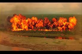
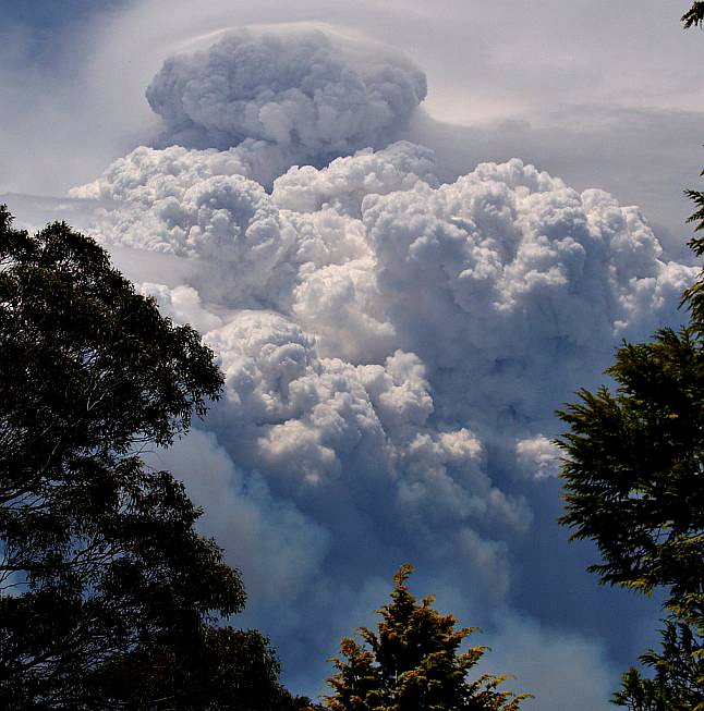