Archive for the ‘Blue Mountains (AU)’ Category
Tuesday, September 13th, 2011
The following letter to the editor appeared in the Blue Mountains Gazette newspaper on page 12 of 10th August 2011, written by Rose and Brett Everingham of Lapstone, Blue Mountains, Australia.
")
‘Native Wildlife Alert’
.
‘On the evening of Tuesday July 29 a beautiful Echidna was unfortunately hit by a car outside our house.
We would like to publicly thank the three lovely young gentlemen who stopped to assist us as we moved it off the road, and then rang WIRES.
It was a particularly upsetting experience, no one wants to see any creature hit by a car, especially our native wildlife. The young gentleman who hit the Echidna was understandably distressed, as it is not something you would usually expect to see, and we reassured him that it was simply an accident.
It is a timely reminder though to take care when driving at night, particularly on Governors Drive which is often used as a race track for some drivers. Unfortunately the Echidna could not be saved. Once again a thanks to the young gentleman who stayed with my husband and son whilst they buried it.
Whilst a sad experience, it brought relief to know that Lapstone still has such beautiful native wildlife existing amongst us in the bush.’
.

.
.
Editor’s Comments:
.
1. The killing of a native echidna by a driver of a car is an horrific tragedy for the echidna and its likely dependent mate and offspring, which were not mentioned. Each killing of adult native wildlife harms the viability of the local population of that species in the area.
2. Rose and Brett are right to have done what they did and it is valuable to the local community that Rose has taken the trouble to share this tragic event via her letter in the local paper.
3. The cause of the Echidna’s death was that the car driver was driving too fast to prevent killing it on the road. Most drivers drive too fast and are not competently trained to drive for the conditions.
It could have been a child killed while running on to the road. I am sure the local paper would have had more than allowing Rose’s letter, which reflects our culture that human life holds selfishly somehow higher values than wildlife. One may call this ‘speciesism’, a term few are aware.
4. Echidna habitat was there many thousands of years before European colonists destroyed its environment and selfishly carved a road through its habitat, with no care for any native wildlife values.
5. Such roads as Governors Drive, whether constructed by local Blue Mountains Council or larger ones by the Roads and Traffic Authority (RTA), not only destroy native vegetation and wildlife habitat in their construction, as well as allowing sediment pollution of downhill watercourses; no respect is paid to the inevitable road death consequences caused by vehicles using the road. The underlying reason is that human values for wildlife are so low across the community that there is hardly any call for wildlife protection from the threats of road making and its consequential traffic menace. Worse is that perverted attitudes toward wildlife and deviant behaviour prevail to the extent that the killing of wildlife on our roads is disparagingly dismissed as ‘roadkill’. If the same term were applied to pedestrian deaths on our roads, there would be an uproar by extreme humanists.
6. No attempt is made by road builders (local council or the RTA) to facilitate separation of ground dwelling native wildlife from the inevitable risk of death from introduced road traffic. Some roads across Australia have wildlife fencing to prevent native animals such as wallabies, wombat and Echidnas from accessing the road. Others factor wildlife corridors into the design of roads that destroy wildlife habitat. It is an indictment on both the Blue Mountains Council and the RTA that there are no wildlife fences or wildlife corridors throughout the Blue Mountains.
")
7. That Rose wrote “it is not something you would usually expect to see” is a sad indictment on the demise of wildlife populations across the Blue Mountains since colonial conquest, such that now people living in the Blue Mountains do not expect to see wildlife any longer. Villages like Lapstone have become so urbanised that they are all but outer suburbs of Sydney. The natural bush environment has been lost to a sterile parkland to suit the needs of humans. The values of native wildlife and their habitat continue to be ignored by humans who live and drive through the Blue Mountains and by custodial government authorities – Blue Mountains Council, NSW Department of Environment (etc), Australian Department of Environment (etc).
") . .
Yet, despite the arrogant disregard for wildlife values across the Blue Mountains, especially at the human interface, other regions take a more proactive view, such as in Sydney’s Northern Beaches region.
.
") Uncontrolled speeding on Australian roads Uncontrolled speeding on Australian roads
.
Related Articles:
.
‘Wallaby becomes roadkill after fence holed’
.
by Brenton Cherry, 20110112, Many Daily, ^http://manly-daily.whereilive.com.au/news/story/wallaby-becomes-roadkill-after-fence-holed/
 Eira Battaglia, Mandy Beaumont, Niamh Kenny,
Cassie Thompson and Elvira Lanham at the damaged fence.
(Photo by Virginia Young) Eira Battaglia, Mandy Beaumont, Niamh Kenny,
Cassie Thompson and Elvira Lanham at the damaged fence.
(Photo by Virginia Young)
.
‘A hole has been cut in the wildlife-proof fence along Wakehurst Parkway at Oxford Falls, leading to at least one wallaby being killed. The death – discovered by Jacqui Marlow from the Northern Beaches Roadkill Prevention Group – was the first along the stretch of road since the fence was installed.
“Why would anyone cut a hole in the fence?” she said. “I found the hole after seeing a dead wallaby in the fence area.
“It’s the first one killed in the fence area since it was installed, which shows that it works.”
Ms Marlow said she had become disenchanted by the actions of some people.
“At the moment my opinion of humans is not very good, especially when it comes to their attitude to nature,” she said. “I’m really tired of dealing with it, the deaths are starting to get me down.”
Fellow group member Eira Battaglia said now more than ever motorists had to be aware of wildlife on our roads.
“Wallabies are around after the recent burn-off,” she said.
“Eight have been killed in the past week so please drive carefully, especially at dusk when the wallabies may be out searching for food.”
A spokesman for the RTA said a maintenance crew would permanently fix the hole as soon as possible. “A temporary repair has already been carried out,” he said.
RTA representatives yesterday met with the roadkill prevention group for a tour of local hot spots and potential sites for additional fauna fencing.’
.
.
‘Peering down the corridor’
.
Source: ^http://www.coolmelbourne.org/articles/2009/07/peering-down-the-corridor/
 Wildlife Corridors do exist and are effective where human communities
care enough to insist on them.
But don’t expect road designers and engineers in Australia to suggest the concept. Wildlife Corridors do exist and are effective where human communities
care enough to insist on them.
But don’t expect road designers and engineers in Australia to suggest the concept.
.
.
‘Conservationists have long recognised the value of using wildlife corridors to connect wilderness areas, and there is mounting evidence to show that these corridors help many species, from the big to the small to the airborne to the aquatic.
But now ‘megacorridors’ are taking the wildlife corridor concept to a whole new level. Australia’s Great Eastern Ranges Initiative (GERI) is Australia’s answer to the megacorridor.
Aiming to create a 2800km wilderness megacorridor from North Queensland to Victoria, the initiative is about halfway towards completion of the first and most critical stage.saving-wilderness-geri-map-new-scientist.jpg
It is an extremely important move in the conservation of Australia’s biodiversity: after more than 200 years of development, the landscape of eastern Australia has changed significantly.
Fences, roads, dams, industrial and agricultural lands, powerlines, towns and cities cut across the country, isolating natural areas which have become ‘islands’ on which plants and animals have become isolated.
This means that many ecosystems have been fragmented, that the landscape’s capacity to maintain our unique plants, animals and Aboriginal cultural heritage has been reduced. It also means that remaining ecosystems are finding it harder to filter and clean our air, maintain the health of our soils, and produce unpolluted fresh water for the 93% of the Australian population that lives along Australia’s eastern seaboard.
This is no quick fix project however: climate change and the migration of human populations means it could take as long as 100 years before the project’s success can be measured.’
.
.
‘Wildlife corridor from far south to far north’
.
by Mat Churchill, 20100716, ^ http://www.tourismportdouglas.com.au/Wildlife-corridor-from-far-south-to-far.4317.0.html

The Great Eastern Ranges Initiative, a proposed 2,800km long conservation corridor
Patches of state and national parks around the country just aren’t sufficient to protect Australia’s native plants and animals.
According to a report commissioned by the NSW Department of Environment, Climate Change and Water, a wildlife corridor 2,800km long stretching from Melbourne to the Atherton Tablelands would allow species to migrate when their habitat changes due to climate change.
”One of the impacts of climate change is that species will have to move around to find suitable habitat resources. We need to make the whole landscape more biodiversity friendly.” said Brendan Mackey, an environmental scientist who wrote the report.
Dubbed the Great Eastern Ranges Initiative, the corridor would be made up of public and privately owned land.
Ian Pulsford, from the Department of Climate Change and Water, said areas earmarked to become part of the corridor would see a person acting as a broker visit the private landholder to discuss the program.
”The corridor is voluntary but there has been a good response from private landholders, and there are incentives to make your land part of the conservation area,” said Mr Pulsford.
The corridor concept is a new way of thinking when it comes to conservation. And a change in the way we do things in Australia is clearly needed when nearly half of the world’s mammal extinctions in the last 200 years have happened here, along with 61 species of flowering plants among others. The world’s current extinction rate is 1,000 higher than nature intended.
”The conventional thinking is wait until things are really bad and then desperately try to save things at the last minute,” said Professor Mackey.
.
.
Further Reading:
.
[1] ^http://www.coolmelbourne.org/our-environment/wildlife/
.
– end of article –
Monday, September 5th, 2011
 The Gully Water Catchment (Photo by editor 20110502, copyright free in the public domain) .
The Habitat Advocate’s raison d’être
Habitat Campaigning best starts close to home. If everyone took this approach then the natural environment would be far more intact, the wildlife habitat more viable to sustain local wildlife, and the risk of species extinction far lower than where current trends are heading.
The Habitat Advocate established as a volunteer conservation group back in 2001 on the edge of a small steep creek valley within what we term The Gully Water Catchment based at The Habitat Advocate founder’s residential home on the bushland fringe of the regional township of Katoomba, situated in the central Upper Blue Mountains of New South Wales in Australia.
The reference to this creek valley as ‘The Gully‘ is the historical affection name for the valley by former resident tenants.
Our raison d’être (purpose in forming) initiated on one Saturday morning within a few weeks of the founder, Steven, moving into his recently acquired house and suddenly being impacted by the roar of racing Mini Cooper cars down in the creek valley less than 100 metres away. Having had all due diligence in conveyancing previously undertaken ahead of purchasing the property and the previous tenant advising how quite the area was, no mention had been made of the deafening motor racing circuit! Local Blue Mountains [city} Council (local council) maps had labelled the small surrounding valley as ‘Katoomba Falls Creek Valley‘, with the northern portion near our house named by Council as ‘Frank Walford Park‘, but NOT as ‘Catalina Park‘ motor racing circuit.
So that was it, the battle to end the motor racing commenced.
Steven soon learned about a local grassroots activist group of residents living around the edge of this creek valley, which had formed back in 1989 initially and primarily to end the car racing use of the valley and also to respect and rehabilitate the creek valley’s natural ecology. Steven joined them in 2002 – ‘The Friends of Katoomba Falls Creek Valley Inc.‘ (‘The Friends’), led by the now late Neil Stuart [1937-2016].
Between 2002 and 2007, Steven volunteered in The Friends working group’s activities – lobbying local council to end the racing, participating in community meetings about the valley, meeting with former residents of ‘The Gully’ (mostly Aboriginal), writing letters in the local Blue Mountains Gazette newspaper, undertaking bushcare weeding and rubbish clean ups in the valley, and generally monitoring and reporting unsavoury goings such as illegal squatting by transient outsiders.
During those early years, The Friends learned about the tragic history of the creek valley’s 1957 forced eviction of former tenants by Council and its bulldozing of their homes so that the racetrack could be constructed. The former tenants had referred to the creek valley as The Gully – mainly the northern portion of what Council had named Frank Walford Park after one of its mayors of the 1950s who had approved the racetrack usurpation* of the land previously known by former residents as The Gully. A number of members of The Friends were indeed former residents of the valley – Aboriginal, non-Aboriginal, as well as intermixed local families.
[Ed: *Usurpation is the act of taking somebody’s position and/or power without having the right to do this. Land Usurpation is the appropriation of land from the previous or lawful owner].
In 1995, local council had renamed ‘Katoomba Falls Creek Valley‘ to being ‘Upper Kedumba River Valley‘. In around 2007, The Gully Traditional Owners decided to rename The Gully as ‘Gungaree’ in Gundungurra aboriginal language acccording to historical doctoral research undertaken by Wentworth Falls historian Jim Smith, Ph.D.
Around the time from 2000 to 2002, as chance would have it, there occurred an environmentalist momentum in the area, followed by a local social momentum that firstly had the Blue Mountains region internationally recognised as a natural World Heritage area on Thursday 30th November 2000. Secondly, portions of the valley became recognised and declared by the New South Wales Government as an Aboriginal Place under its National Parks and Wildlife Act 1974 on 18th May 2002. That declaration resulted in local council terminating the car racing in the valley.
So job done! It was certainly a changeable time, and Steven just happened to have arrived from Sydney, originally Melbourne.
By 2007, despite tirelsss efforts of The Friends since forming back in 1989 to persuade local council (as the legal owner of the valley) to end the racing and to consult with interested local residents around the valley and about managing a natural rehabilitation process for the valley, that was not to be.
Instead, council bureaucracy over the years systematically thwarted all attempts by The Friends, and The Friends’ allied collaborated group The Gully Guardians (2004-2006) from having any say in joint community consultation and rehabilitation management of the valley. In fact, due to the years of The Friends demands upon local council to consult in rehabilitate the valley and The Friends’ relentless and strident criticism of local council (whilst valid in this author’s view), local council went further.
By 2007, local council had completely ostracised The Friends from all community consultation concerning the valley and had bureaucratically driven a by-law wedge between The Friends and the local Aboriginal people who had been former residents of the valley before 1957.
By 2007, local council had chosen to side solely with the newly formed Gundungurra Aboriginal group, The Gully Traditional Owners, in an exclusive management partnership for the valley. From local council’s bureacuratic standpoint The Friends had effectively become personae non gratae.
It wass in this year, that Steven sadly decided to resign from The Friends and focus his environmentaliost attention upon building the website of the Habitat Advocate.
All the while and since then, Steven has continued to maintain close good friendship and communication with members of The Friends.
The Gully Water Catchment?
In the upper Blue Mountains, a creek and series of wetlands following the upper reaches of the Upper Kedumba River above Katoomba Falls form an elongated upland valley covering an area of more than 100 hectares. This creek valley has been known for many decades by its former residents and their descendants affectionately as ‘The Gully’. Over more than a century since the 1870s, this natural valley was steadily deforested and around the fringes subdivided for housing so that the remnant natural area has been reduced to under 70 hectares..
Situated next to the township of Katoomba, The Gully has long been surrounded by housing development above it atop its steep valley embankments. Yet, The Gully held important ancestral cultural values to traditional Aboriginal peoples of the Gundungurra, Darug, Wanaruah, Wiradjuri, Darkinjung and Tharawal of the greater Blue Mountains region and adjoining lands. These values contimue to be held by formre residents of the Gully and current generations.
The Gully has been a ceremonial meeting place for traditional peoples of the Blue Mountains for perhaps thousands of years. Since colonial settlement at Katoomba in the 1870s, The Gully has provided a secure haven for poor people both black and white, who although living in basic squat conditions in the extremes of Mountains weather, lived together as a close knit community; the Congregational ‘Mission’ Church for many years having played a key uniting role for Gully folk and as an informal umbrella protecting authority to stave off designs on the place by selfish others.
") Jimmy War Sing, Chinese market gardener and fruiterer on his sulky in The Gully; the poor horse not well fed.
His ‘Chinese Garden’ was situated in a natural gully with a small watercourse running through it behind Loftus and Neale Streets (McRae’s Paddock).
(Photo circa 1903), supplied by Colin Slade in Pict. Memories Blue Mountains, John Low 2002)^http://www.flickr.com/photos/blue_mountains_library_-_local_studies/2669879647/ . Jimmy War Sing, Chinese market gardener and fruiterer on his sulky in The Gully; the poor horse not well fed.
His ‘Chinese Garden’ was situated in a natural gully with a small watercourse running through it behind Loftus and Neale Streets (McRae’s Paddock).
(Photo circa 1903), supplied by Colin Slade in Pict. Memories Blue Mountains, John Low 2002)^http://www.flickr.com/photos/blue_mountains_library_-_local_studies/2669879647/ .
Two particular historic events have adversely impacted upon The Gully’s ecological integrity and its human community. The first event was the bulldozing of the natural swamp of frogs hollow in the 1940s by developer Horace Gates to construct a dam as an artificial lake as part of his theme park scheme for the Gully. A few years later a Catalina flying boat was floated in the dam (lake) as a tourism draw card. At some time in the late 19th Century a local by the name of McRae, decided to bulldoze and infill the wetland in the mid part of the valley so that he could graze his horse stock.

The second event was the bulldozing of the entire top valley including the homes of several families in 1957 by the Blue Mountains Council in collaboration with a local fraternity car racing drivers and local businessmen to make way for a motor racing circuit – ‘Catalina Raceway’. Those families were forcibly evicted from their homes, extricated from The Gully and one woman died of a heart attack during the raid.

Catalina Raceway was used for motor racing through the 1960s, by the 1970s the racing circuit had steadily fallen into disrepair. This was due to a number of factors – repeated foggy weather at many racing events, the inability of the racing association to repay its construction debt to the Blue Mountains Council, new competition from circuits nearer to Sydney (Oran Park and Amaroo Park), and due to the prohibitive cost of increasing motor racing safety standards, prompted by the death of two racing drivers on separate occasions at ‘Craven A Corner’.

The track became overgrown and weeds spread throughout the valley. Blue Mountains Council named the valley ‘Catalina Park‘, and later named the top northern part of the valley as ‘Frank Walford Park’ after the namesake of a previous councillor who had been a key decision maker in approving the racetrack be built. Car racing at Catalina, culminating in the formation of the Blue Mountains Tourist Association.

Catalina Raceway was a form of early Blue Mountains tourism and became very popular with car racing enthusiasts during the 1960s and 1970s.
In 1989, local nearby residents concerned about the poor state of the valley and with a desire to stop the car racing and protect the natural values of the valley, formed The Friends of Katoomba Falls Creek Valley, Inc. (‘The Friends’).
This grassroots local community group of local Katoomba residents established as one of the first bushcare groups in the Blue Mountains and since then their volunteers have regularly engaged in bush regeneration throughout the valley.
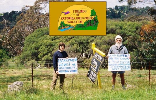 One of many protests by members of ‘The Friends’ (1989-2016) to save The Gully (‘the Valley’) from harm mainly from housing developers and tourism operators seeking to profiteer. In this photo locals Ivan Jeray and the late Neil Stuart (joint founder of The Friends) in 2005 protesting about the proposed massive deforestation and subdivision of this remnant side gully into a 69 lots of new houses dubbed 21 Stuarts Road Katoomba.
The Friends also galvanised local community support to stop the racing and to rehabilitate the valley back to its natural condition, holding street stalls to raise funds and to raise community awareness over the plight of the long neglected valley. The Friends lobbied Blue Mountains Council over nearly three decades to have the car racing banned, to have the weeds removed and to restore the valley to its pre-1957 natural state.
The Friends’ became instrumental in having plans prepared for the rehabilitation for the valley, most notably the 1993 Bell Report prepared by environmental consultant Fred Bell, the only one done so in consultation with the local community. To date, none of the several plans drafted has been put into effect by local council, so the Gully remains neglected and the race track long abandoned, yet the natural bush vegetation is steadily recovering.
In 2000, local Darug elder, Aunty Dawn Colless, was instrumental in achieving proper recognition for The Gully as an official Aboriginal Place under the New South Wales National Parks and Wildlife Act. On 18th May 2002, regrettably after Dawn’s passing, The Gully became protected under Sections 84, 85 and 90 from development and all racing formally banned.

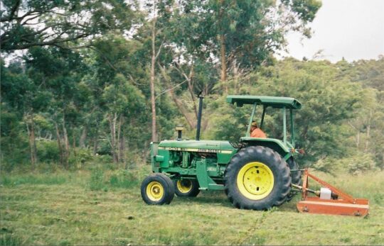 We dubbed this tractor towing a mower/slasher as ‘Hector’. It has been a notorious tool of destruction of the ecology of The Gully, also known for decades as Katoomba Falls Creek Valley.
Concerned local residents around The Gully back in 1988 began to realise that this natural creek valley immediately upstream and feeding Katoomba Falls and Kedumba River with fresh drinking water, was becoming increasingly under threat of destruction from various external vested interests. So in 1989 a mob of them formed a local community environmental conservation bushcare and activist group , The Friends of Katoomba Falls Creek Valley Inc.
This committed volunteer community group ran for some 27 years under the leadership and inspiration of local social worker and teacher, Neil Stuart. Most members of ‘The Friends’ initially lived within the water catchment of Katoomba Falls Creek Valley – a natural amphitheatre of multiple watercourses on the western side of the Blue Mountains township of Katoomba, which covered about 600 hectares.
So yes they were NIMBYS proudly, defending their beautiful natural place from selfish invaders threatening to ruin and exploit the Nature and its natural amenity.
Without the concerted efforts and activism of this committed community group, it is most likely that The Gully would now no longer exist, but be a valley of housing and recreational development.
The purpose of this webpage is to offer a perpetual factual account of the truth about The Gully, its recent history, its stories, its plethora of threats to undermine its integrity, values and spirit over many decades, and the stories of the ongoing abuse, neglect, battles, egos, bias – warts and all.
In 2004, the Blue Mountains {city} Council finally released it 2002 draft Plan of Management for The Gully, however, after seven years is yet to be funded and implemented; council preferring to fund multi-million urban developments such as nearby Katoomba Cultural (Shopping) Centre. In that same year, past Aboriginal residents and descendants of The Gully collaborated with local council management to have an archaeological survey conducted at key traditional cultural sites throughout The Gully.
In early 2006, a collaborative coalition of various community members including traditional Gundungurra and Darug and The Friends and formed ‘The Gully Guardians’, although this was short-lived due to undermining tactics by political interests within Blue Mountains Council causing hostilities. This was superseded by the establishment of the ‘Gully Traditional Owners’ in June 2006 by representatives of the Aboriginal people that had inhabited the Gully over many generations. The Gully Traditional Owners has since that time collaborated with Blue Mountains {city} Council to achieve New South Wales grant funding for restoration works, including a planned interpretative walking track through the Gully.
‘The Gully Cause’
The Gully Cause (i.e. saving it from ongoing abuse and neglect) is an humanitarian one as it is an ecological one.
This creek valley is the site of some of the Blue Mountains most divisive conservation battles that persist – citing the forced evictions by Council, the notorious 1957 bulldozing for a car racetrack, the bulldozing for Katoomba golf course, massive subdivision for housing, council profiteering from land sales for incremental housing development, deforestation for mass tourism, arson, a sports centre development by council, the creek diverted into a dam as part of one of two wacky theme park developments, etc, etc.
The values, history, stories, threats, abuse and neglect remain ongoing. The Habitat Advocate was established in 2006 as a conservation activist organisation based in The Gully water catchment situated in inner west Katoomba.
Since the events of 1957, when council acquired the majority of what was then known as Katoomba Falls Creek Valley upstream of Katoomba Falls to the highway, most of the land has been deemed Council Community Land, so it is largely public open space, except for the many sections sold off for development – both housing subdivision and mass tourism.
The editor of The Habitat Advocate has lived within The Gully water catchment since 2001 and has contributed an active community voluntary role to protect the natural values of The Gully and assist local residents and former residents of The Gully and their descendants in a constructive way. This includes years of Bushcare weeding, SCA Streamwatch drinking water quality monitoring winning five awards from the Sydney Catchment Authority, as well as community activism as a member of the former local Katoomba community group Friends of Katoomba Falls Creek Valley Inc. (affectionately termed ‘The Friends’ by its members), which spanned some 26 years (1989 – 2016) protecting and the defending this natural valley from all sort of development threats.
In addition, our editor was a member of the former Gully Guardians (a joint informal coalition of both local Aboriginal and non-Aboriginal locals and former residents of The Gully and their descendants). I have enjoyed ongoing co-operation with The Gully Traditional Owners.
The Habitat Advocate grew out of its editor’s five year membership of local Katoomba protest action group The Friends from 2002 to 2006. The Habitat Advocate is intimately aware of The Gully’s values, cultural sensitivities, histories, issues and threats that continue to affect this special place.
The Gully Collection
This Habitat Advocate webpage is dedicated to the conservation values of The Gully and remains a work-in-progress, collating various records, documents, images and accounts on The Gully so that locals, past, present and emerging of all persuasions may learn more about the important conservation values of this special place, thus continuing in the conservation spirit of The Friends.
We have amassed a considerable library of knowledge on The Gully spanning a century.
 An early photo of The Gully’s landscape (circa. 1920), taken looking from from the rear of the Balmoral Guesthouse (then 196 Main Street, since renamed Bathurst Road) in Katoomba perhaps by the renowned Blue Mountains photographer Harry Phillips (1873-1944) An early photo of The Gully’s landscape (circa. 1920), taken looking from from the rear of the Balmoral Guesthouse (then 196 Main Street, since renamed Bathurst Road) in Katoomba perhaps by the renowned Blue Mountains photographer Harry Phillips (1873-1944)
The following hyperlinks below are to pages and posts internally on this website that over time will form a reference library of material on The Gully restricted to what is in the public interest – ‘The Gully Collection‘ (created by The Habitat Advocate from 2016):
Wednesday, July 27th, 2011
 (click to enlarge photo) (click to enlarge photo)
‘There is a proposal by (Queensland-based) Coalpac Pty Ltd to mine coal, using high wall and open cut mining techniques. This activity would occur within the Ben Bullen State Forest, this forest adjoins the Gardens of Stone, an amazing area containing rock formations called pagodas.
If this destructive mine is approved, at least 1088 ha of old growth forest will be destroyed, with its iconic, rare flora and fauna. We have an unenviable record of species extinctions, locally and nationally.
Lyrebirds use the sides of the pagodas to nest and raise their young. The area is home to tiger quolls, powerfull owls and more than 30 native animals, five of which are listed as endangered.
Local residents will not suffer from dust in the air, but they, and others further afield, will have their water supply contaminated.
Please write to Mrs Roza Sage (Liberal Party Member for Blue Mountains electorate) to express your concern about this irreplaceable environment at risk frominappropriatre and unnecessary mining development.’
Anne Dillon, Blackheath.
.
[Source: Blue Mountains Gazette, ‘Threat to forest’, 20110713, page 12, Blue Mountains, New South Wales Australia]

.
Further reading:
.
[1] ^http://fatcanyoners.org/2011/05/14/gardens-of-stone-protest/
Friday, June 10th, 2011
One by one, roadside vegetation, roadside communities, and villages through the Blue Mountains are capitulating to the New South Wales Government’s agency, the Roads and Traffic Authority (RTA). One diesel-driven programme to convert a regional highway into a dangerously fast heavy trucking expressway.
The RTA is an ‘authority’ alright – a testament to when absolute authority is allowed to overrule local values at any cost.
 Leura, Blue Mountains, Australia, 22nd Dec 2006)
(click photo to enlarge) Leura, Blue Mountains, Australia, 22nd Dec 2006)
(click photo to enlarge)
.
 RTA rainfall retention gross failure, Leura 30th June 2005
(click photo to enlarge) RTA rainfall retention gross failure, Leura 30th June 2005
(click photo to enlarge)
.
 Trees hacked to make way for the RTA expressway, 4th February 2007
(click photo to enlarge) Trees hacked to make way for the RTA expressway, 4th February 2007
(click photo to enlarge)
.
 RTA construction sediment down the drain and into Blue Mountains World Heritage creeks, 16th January 2006
(click photo to enlarge) RTA construction sediment down the drain and into Blue Mountains World Heritage creeks, 16th January 2006
(click photo to enlarge)
Thursday, June 2nd, 2011
 Jamison Valley from Sublime Point, Leura
(Blue Mountains, New South Wales, Australia) Jamison Valley from Sublime Point, Leura
(Blue Mountains, New South Wales, Australia)
.
For those who have purchased an escarpment-edge bush block in Blue Mountains villages of Leura, Wentworth Falls or Katoomba, who have ‘arranged‘ for native escarpment habitat to be killed in order to gain property views to the magnificent Jamison Valley, such actions are selfish and contribute to the ecological vandalism and disappearance of important and scarce escarpment habitat.
For others enjoying the Jamison Valley naturally on foot, to look back up at the Leura escarpment has become an ugly one dominated by increasing housing development.

Views are bidirectional, but try explaining that to a property developer or to those real estate agents who only appreciate the sales commission.
On the spectacular escarpment fringe of the much valued village of Leura in the much valued Blue Mountains, not only have the fire-lighters taken a fancy at setting fire to nearby prized escarpment bushland, but the property developers have been in with the bulldozers.
The Blue Mountains (city) Council has for decades signed off on developer applications for clifftop development and consequential deforestation. More recently, Blue Mountains (city) Council continues to happily signed off on approval of applications from subsequent clifftop property owners to ‘hazard reduce’ the surrounding escarpment bushland ~ either to improve the views or to save money having to bushfire protect their properties.
Either way, valuable limited habitat along the Blue Mountains escarpment overlooking the Jamison Valley continues to disappear for new selfish housing views.
All along the Jamison Valley escarpment, the following photos tell a tragic story of the selfish developer destruction of the Jamison Valley Escarpment …
 Wildlife Service ‘hazard reduction’ burn notice for Sublime Point escarpment at the end of Willoughby Road, Leura back on 15th March 2008.
(click photo to enlarge) Wildlife Service ‘hazard reduction’ burn notice for Sublime Point escarpment at the end of Willoughby Road, Leura back on 15th March 2008.
(click photo to enlarge)
.
 Warrimoo Rural Fire Service set up to conduct hazard reduction at Sublime Point, Leura (Carleton Road, Leura, 15th March 2008). Warrimoo Rural Fire Service set up to conduct hazard reduction at Sublime Point, Leura (Carleton Road, Leura, 15th March 2008).
.

Rural Fire Service setting fire to escarpment vegetation at Sublime Point on the Jamison Escarpment, Leura. (Photo from Willoughby Road,Leura, 15th March 2008).
.
A year later again at Sublime Point…
.
 DECC Wildlife Service ‘hazard reduction’ burn notice for Sublime Point escarpment again on 24th March 2009, almost exactly a year to the date. DECC Wildlife Service ‘hazard reduction’ burn notice for Sublime Point escarpment again on 24th March 2009, almost exactly a year to the date.
.
 Blue Mountains Wildlife Service ‘hazard reduction’ burn of the Jamison Escarpment at Sublime Point 24th March 2009 Blue Mountains Wildlife Service ‘hazard reduction’ burn of the Jamison Escarpment at Sublime Point 24th March 2009
.
 Blue Mountains Wildlife Service ‘hazard reduction’ burn of the Jamison Escarpment at Sublime Point 24th March 2009. Blue Mountains Wildlife Service ‘hazard reduction’ burn of the Jamison Escarpment at Sublime Point 24th March 2009.
.
 Fire-lighters watching on as their blaze gets out of control at Sublime Point 24th March 2009.
(Click photo for enlargement) Fire-lighters watching on as their blaze gets out of control at Sublime Point 24th March 2009.
(Click photo for enlargement)
.
.
 Same ‘hazard reduction’ burn out of control, requiring expensive and embarrassing helicopter water-bombing to stop the fire spread down into the protected Jamison Valley Same ‘hazard reduction’ burn out of control, requiring expensive and embarrassing helicopter water-bombing to stop the fire spread down into the protected Jamison Valley
 East side of Sublime Point (5th April 2009) showing burnt vegetation, where the HR burning had escaped and nearly entered down into the Jamison Valley.
(The media spin by bushfire management was that this section was arson, but not surprisingly the culprit was never found). East side of Sublime Point (5th April 2009) showing burnt vegetation, where the HR burning had escaped and nearly entered down into the Jamison Valley.
(The media spin by bushfire management was that this section was arson, but not surprisingly the culprit was never found).
.
nec.
Meanwhile, property developers at Sublime Point, a block away…
.

Leura’s recently approved and created ‘ The Links Road‘ (31st May 2008) following Council approved destruction of escarpment vegetation and subsequent subdivision ready for escarpment housing..with views.
.
Meanwhile, further along Cliff Drive at Katoomba…
.
 Editor inspecting native escarpment site on Cliff Drive, Katoomba back on 12th January 2008 that had been recently slashed by the Wildlife Service.
It just so happened that a house opposite on Cliff Drive was up for sale and would benefit from the fresh views of the Jamison Valley. Editor inspecting native escarpment site on Cliff Drive, Katoomba back on 12th January 2008 that had been recently slashed by the Wildlife Service.
It just so happened that a house opposite on Cliff Drive was up for sale and would benefit from the fresh views of the Jamison Valley.
 Same site, same date. Same site, same date.
.
 Seven months later, a few hundred metres west along Cliff Drive Katoomba,
some developer gets escarpment views towards Nellies Glen approved,
or is it more a case of ‘overlooked‘ by Blue Mountains (city)Council? Seven months later, a few hundred metres west along Cliff Drive Katoomba,
some developer gets escarpment views towards Nellies Glen approved,
or is it more a case of ‘overlooked‘ by Blue Mountains (city)Council?
.
.
.
-end of article –
Tags: Blue Mountains City Council, Blue Mountains western escarpment, Blue Mountains World Heritage Area, bushland housing, hazard reduction, housing encroachment, Jamison Valley, Katoomba, Leura, Links Road, NPWS, prescribed burning, Sublime Point, Wentworth Falls, Wildlife Service
Posted in Blue Mountains (AU), Threats from Bushfire, Threats from Development | No Comments »
Add this post to Del.icio.us - Digg
Saturday, May 28th, 2011
Valuable fringe bushland of the Central Blue Mountains (BM) is steadily disappearing as a consequence of Blue Mountains (city) Council-approved housing development integrated with the associated hazard reduction burning that it invites.
Blue Mountains Council has become culturally conditioned to automatically squirm and acquiesce when any threat of a State Environmental Court appeal process that may be instigated to dare challenge Blue Mountains Council, despite a fair and rigorous environmental assessment and ruling. Local political pressure is such that now Blue Mountains Council staff are encouraged to give up and bend over, as if so urbane as to be beholden to developer intimidation. Yet for years such has become Blue Mountains Council’s urbane squeamish mindset, as if the staff and management came from overdeveloped Western Sydney (which most of them they have).
There are morally corrupt politics controlling land use development in the Blue Mountains ~ many are receiving a cut of perceived cheap, yet increasingly scarce, bushland habitat.
 Thick natural bushland habitat just west of Katoomba
Central Blue Mountains Region.
New South Wales, eastern Australia. Thick natural bushland habitat just west of Katoomba
Central Blue Mountains Region.
New South Wales, eastern Australia.
.
.
Case in point:
.
Not so long ago, Blue Mountains Council approved this cypress pine cottage be built in/abutting thick timbered bushland on a west facing slope downwind of the prevaling westerly winds.
Bushfire risk mapping rated the site as ‘extreme’ bushfire risk, yet the cypress pine cottage got built. The builder/developer has long since profited and so moved on, leaving behind a bushfire vulnerable cottage on a site that should never have been built on in the first place.
But try telling a pro-development council that a property owner can’t develop his/her land!
 The cypress pine cottage, 2008
. The cypress pine cottage, 2008
.
The site was purchased in/abutting dense wooded bushland, which was slashed and bulldozed. Down from the house, around a dozen mature native trees were chainsawed to provide for escarpment views to the west.
 One of the chainsawed native trees
. One of the chainsawed native trees
.
The property has since been sold. Yet, the issue of a cypress clad cottage being approved in extreme fire risk bushland was raised with Blue Mountains Council’s senior development officer, Lee Morgan, on 25-Feb-2009 (Council ref. Customer Service Request #106889). But there was no response.
 The cottage was sold in 2008…with views
…less the dozen chainsawed Eucalypts to make way for the views. The cottage was sold in 2008…with views
…less the dozen chainsawed Eucalypts to make way for the views.
.
It is typical of Blue Mountains Council’s planning approvals that they encourage development encroachment on the fringe bushland which separates the Blue Mountains National Park from the townships of the Central Blue Mountains.

 A nearby cottage of remarkably similar cypress pine cladding
has surrounding trees chainsawed and the vegetation slashed to bare earth. A nearby cottage of remarkably similar cypress pine cladding
has surrounding trees chainsawed and the vegetation slashed to bare earth.
.
.
Then comes the ‘hazard’ reduction
.
Housing development encroachment is being wedged deeper into fringe bushland, closer to the Blue Mountains National Park, many seeking the profit that escarpment views bring. The sites are indefensible against bushfire. Many are zoned extreme bushfire risk, yet these bush houses received Council building approval.
The Rural Fire Service (RFS) calls for hazard reduction because, with just its truck resources, it would not have access to defend these houses in the event of a serious bushfire. Co-incidentally, the property owners (developers) now cry for RFS hazard reduction to protect their ‘assets’ from the risk of bushfire. Co-incidentally, many property owners (developers) in the vicinity who have these new bush houses do the same.
Of course, to the fire-lighting cult, this is music to their ears and so the Rural Fire Service in cohorts with Blue Mountains Council rustled up a hazard reduction certificate. In September 2008, Blue Mountains Council’s Bushfire Technical Officer, Peter Belshaw, issued a Hazard Reduction Certificate for over 11 hectares of bushland and escarpment heath across Bonnie Doon Reserve to be burnt under a ‘hazard’ reduction programme. Click on image below for details.
 Click image to open PDF document Click image to open PDF document
.
Earlier that year in mid February (2008), some seven months prior, slashing of heathland and a watercourse had been carried out by a Rural Fire Service contractor in preparation for the hazard reduction burning ~ the fire-lighters just couldn’t wait.
 Blue Mountains escarpment is slashed by the RFS, a kilometre west of the cottage site. Blue Mountains escarpment is slashed by the RFS, a kilometre west of the cottage site.
.
.
 The RFS contractor slashed a trail for over 700m through heathland and through a riparian zone,
even before the Hazard Reduction Certificate was issued.
.
The RFS contractor slashed a trail for over 700m through heathland and through a riparian zone,
even before the Hazard Reduction Certificate was issued.
.
Then comes the intense HR burning:
.
Three years hence, mid afternoon on Friday 11th February 2011, smoke can be smelt and seen rising to the west on the horizon near Bonnie Doon Reserve. A call to emergency ‘000’ confirms that it is not a bushfire, but that official hazard reduction operations are underway. It is still well within the bushfire risk season.
.
Bonnie Doon Reserve is a natural wild area of about 22 hectares that includes a mix of bushland, heathland and upland swamp situated on the Blue Mountains escarpment at the western fringe of the township of Katoomba. It lies above Bonnie Doon Falls. The area is zoned ‘community land’ and ‘environmental protection’ and comes under the control and custodianship of the Blue Mountains Council. Bonnie Doon Reserve has a history of volunteer bushcare to conserve the still wild Blue Mountains escarpment habitat. The reserve is immediately upstream of the endangered Dwarf Mountain Pine (Microstrobos fitzgeraldii) and Leionema lachnaeoides (yellow flowering shrub) found almost nowhere else on the planet. The habitat conservation of both species, particularly the exclusion of fire are considered critical to their survival as a species.
 The ‘hazard’ reduction (HR) burning commences The ‘hazard’ reduction (HR) burning commences
.
From a distance of about two kilometres, I can see the smoke billowing strongly and its lasts for over two hours. The direction of the smoke places it around Bonnie Doon Reserve. The strength and density of the smoke indicates that it is more than light burning of ground cover. It is an intense but localised fire.
.
The aftermath of the burning:
.
We have our suspicions, but with other commitments we can’t get around there for some time to investigate the location affected to determine the scale and severity of the burning. In fact it isn’t until nearly three months later on Sunday 1st May 2011, that we inspect the burnt site. The fire was localised.
 The aftermath
Three months on, evidence of more than just ground-cover has been burnt.
Deliberate intense burning has been allowed to penetrate deep into mature Eucalypts The aftermath
Three months on, evidence of more than just ground-cover has been burnt.
Deliberate intense burning has been allowed to penetrate deep into mature Eucalypts
.

.
 The fire was so intense that the flames reached into the tree canopy.
It must have been a blaze and half for RFS fire-lighters. The fire was so intense that the flames reached into the tree canopy.
It must have been a blaze and half for RFS fire-lighters.
.
.
 RFS telltale
. RFS telltale
.
The fire was indeed localised. It is very clear, still three months on, that this ‘hazard’ reduction burn had specifically targeted the native bushland surrounding the cypress cottage – an area of perhaps two hectares.
Consequence:
So not only has the developer of the cottage site completely destroyed the bushland on the site, but he has succeeded in having an additional two hectares burnt in the process all associated with the one cottage. Council’s initial approval of the cottage construction has directly led to the destruction of two hectares of what began as intact native bushland. The developer has profited from the bush, but in the process the ecological cost has been ignored ~ it is a perpetuation of a 19th and 20th Century single bottom line exploitation of the natural environment. It is happening across the Blue Mountains and being encouraged by Blue Mountains Council rules, practices and attitudes.
.
") The cottage relative to the HR burn (aftermath) The cottage relative to the HR burn (aftermath)
.

The cottage now with great views, plus an extra 2 hectares of cleared bush done cheap
Blue Mountains (city) Council making bushland-fringe development cheap
.
The ‘hazard’ reduction certificate process has become an insidious part of the development process across the Blue Mountains. The catalyst that is Council’s lax bushland protection zoning, is facilitating fringe deforestation. The combination of Council’s housing approvals on bush blocks with its ‘hazard’ reduction approvals have become a self-perpetuating twin mechanism for incremental encroachment into Blue Mountains fringe bushland, and it shows no sign of stopping.
 Bushland habitat at Bonnie Doon at risk of further burning Bushland habitat at Bonnie Doon at risk of further burning
.
Hazard reduction has become a cosy win-win-win-win outcome for all collaborators: (1) the builder/developer who profits, (2) the real-estate agent who get the sales commission (first when the bush block is sold, then again when the house is sold with views), (3) Council which earns developer charges in the short term and an expanded rate revenue base over the long-term, and (4) the RFS fire lighters who have become more adept and occupied lighting bushfires than putting them out.
 Fire-lighters look on during the Hazard Reduction Burn, Bonnie Doon Reserve Fire-lighters look on during the Hazard Reduction Burn, Bonnie Doon Reserve
.
 More bushland for sale
~ a ‘lose-lose’ outcome for native habitat and the remnant disappearing wildlife is supports.
More bushland for sale
~ a ‘lose-lose’ outcome for native habitat and the remnant disappearing wildlife is supports.
.
An harbinger of more burning for Bonnie Doon:
.
Of the eleven odd hectares of the 22 ha Bonnie Doon Reserve targeted by the RFS for slashing and burning on the hazard reduction certificate, nine hectares of bushland and escarpment heathland still stands to be burnt, which could happen anytime.
 Bonnie Doon Reserve
on the western fringe of Katoomba township Bonnie Doon Reserve
on the western fringe of Katoomba township
(click photo to enlarge)
(Photo by us, so free in public domain)
.
– end of article –
.
 Blue Mountains escarpment is slashed a kilometre west of the house site Blue Mountains escarpment is slashed a kilometre west of the house site
, in preparation for over 11 hectares of buring Bonnie Doon Reserve
Tags: Blue Mountains City Council, Blue Mountains National Park, Blue Mountains World Heritage Area, Bonnie Doon Reserve, bush block for sale, bush fringe development, bush profits, bushland housing, Dwarf Mountain Pine, extreme bushfire risk, hazard reduction, hazard reduction certificate, housing encroachment, Leionema lachnaeoides, Microstrobos fitzgeraldii, property development, real estate land sales, Rural Fire Service, slashing
Posted in Blue Mountains (AU), Threats from Bushfire, Threats from Deforestation, Threats from Development | No Comments »
Add this post to Del.icio.us - Digg
Saturday, May 21st, 2011

Wildlife Service sets fires to another 3000ha of World Heritage bushland
.
Last Wednesday (18th May 2011) right across the Blue Mountains, thick smoke choked the sky in a eye watering haze. By Friday, an artificial red sunset was blazing through the wood smoke at the end of two days of New South Wales government-sponsored bush arson.
I knew exactly the ecological disaster unfolding, out of sight out of mind.
In its annual misguided winter ritual, the National Parks and Wildlife Service (Wildlife Service), aided and abetted by the Rural Fire Service has deliberately setting fire to remote bushland across The Blue Mountains World Heritage Area – a ‘natural planet asset’ of which the Wildlife Service is international custodian.

.
Linden Ridge HR Ops (May 2011)
.
On Wednesday afternoon 18th May 2011, the aerial incendiary bombing commenced at Linden Ridge and extended down to the Grose River inside the Blue Mountains National Park (within designated wilderness within the World Heritage Area). Bushfire management euphemistically call it ‘hazard reduction‘ (HR) ; rejecting any notion that bushland habitat is a natural asset, and instead demonising it as a ‘hazard’.
.
Massif Ridge HR Ops (May 2010)
.
The Linden Ridge ‘ops’ follows an almost identical HR ‘ops’ conducted the same time last year on 12 May 2010 in which aerial incendiary ‘ops’ commenced around Massif Ridge some 12 kilometres south of the town of Woodford in wild inaccessible forested area of the World Heritage Area. Some 2500 hectares of high conservation habitat bushland in a protected wilderness area called the ‘Blue Labyrinth’ was indiscriminately incinerated – ridgetops, gullies, everything. Refer to previous article on this website: >’National Parks burning biodiversity‘.
The same Blue Mountains National Park has been targeted by the same aerial incendiary bombing by the same Wildlife Service. Both the operations were carried out under the orders of the Blue Mountains regional manager, Geoff Luscombe.
 This is reducing the ‘hazard’
Click photo to enlarge, then click again to enlarge again and look for anything living.
After a year look for the animals.
After two years look for the animals…. This is reducing the ‘hazard’
Click photo to enlarge, then click again to enlarge again and look for anything living.
After a year look for the animals.
After two years look for the animals….
.
.
.
Gross Valley Defacto HR Ops (Nov 2006)
.
Both the above HR Ops follow the massive conflagration of November 2006, infamously recalled across the Blue Mountains community as ‘The Grose Fire‘. Two abandoned lightning strikes coupled with HR Ops along the Hartley Vale Road and escaping backburns coalesced and incinerated an estimated 14,070 hectares of the Grose Valley and adjoining ridge lands, much of which is designated wilderness. Many consider the actions of the bushfire management response in hindsight to have been a defacto hazard reduction burn. With such an effective elimination of the natural ‘hazard’ that year, as well as the public outrage, HR Ops went quite for four years.

How many animals native to this beautiful Grose Valley suffered an horrific burning death?
How many of their kind have now perished forever from the Grose?
…ask your Wildlife Service at Blackheath!
Charles Darwin in 1836 counted platypus in the area.
.
The perverted rationalisation by bushfire lighting theorists who have infiltrated the Wildlife Service is that the natural bushland, forests and swamps of the Blue Mountains World Heritage Area are perceived not as a valuable natural asset, but as a world ‘hazard’ area to be feared and ‘to be burned in case they burn‘.
These same bushfire lighting theorists have effectively infiltrated, appeased and silenced local conservation groups such as the otherwise very vocal Blue Mountains Conservation Society, the National Parks Association of New South Wales and the umbrella conservation group the New South Wales Conservation Council.
The local conservation movement’s complicity to sanction explicit broadscale ecological harm is a disgraceful and ignoble abandonment of cherished core values, and a breach of duty to faithful environmental membership.
.
.
.
Broadscale indiscriminate ‘HR’ is no different to wildfire or bush arson
The Linden Ridge and Massif Ridge HR Ops were approved and executed by government in the name of ‘hazard reduction’ – to reduce the available ‘fuel’ (native vegetation) for potential future wildfires or bush arson. In both cases, the massive broadscale natural areas burnt were not careful mosaic low intensity burning around houses. This was broadscale indiscriminate fire bombing of remote natural bushland many miles from human settlement. How can the deliberate setting alight of bushland where no fire exists, where no human settlement requires protection from the risk of wildfire be construed but anything other than ‘government-sanctioned bush-arson‘?
.
The ‘Ecological Burn’ Myth
.
When bushfire management can contrive no other excuse for setting fire to native vegetation, such as when that vegetation is many miles away from human settlement and so poses no direct threat, out comes the concocted theory of the ‘ecological burn’. The ‘ecological burn’ theory starts with the premise that because humans have observed that the Australian bush ‘grows back’ (eventually) after a bushfire, it may be concluded that the Australian bush can tolerate bushfires. This hypothesis relies on evidence that selected species of Australian germinate after smoke and fire and the example of epicormic growth of many Eucalypts after fire.
The first deductive fallacy of this theory is that all the Australian bush is bushfire tolerant. This deduction is then extended by unsupported assumption that since the Australian bush is bushfire-tolerant, bushfire must be an integral natural process to which the Australian bush has become adapted to bushfire. The assumption is then extrapolated to assert that bushfire is indeed beneficial to the Australian bush. The assumption is then stretched even further to conclude that without bushfire the Australian bush will be adversely affected. The ecological burn theory then prescribes that by burning the Australian bush, whether by natural or unnatural means, the biodiversity of the Australian bush will be improved.
The deductive fallacy goes further, to suit the motives of the fire-lighters. The outrageous generalisation is made that all the Australian bush must be burnt at some stage for its own ecological benefit. ‘So go forth and burn it. The bush will grow back. It will do it good.’
.
The perverted irrational logic that Australia’s native vegetation has adapted to recover from fire, is akin to claiming the human body is adapted to recover from injury such as burns. A wound may heal but no-one seeks to be injured in the first place. And not all wounds heal. A third degree burn to more than 50% of a human body is almost a certain death sentence. What percentage of a wild animal’s body can be burnt and the animal still survive? That’s a perverted question for the fire-lighters.
Broadscale hazard reduction is not mosaic patch-work fire. It is not creating a small scale asset protection zone around the immediate boundary of a human settlement. It is wholesale bush arson that is driving local extinctions. Ever wonder why when bushwalking through the Australian bush so few native animals are seen these days? Their natural populations have been decimated through two centuries of human harm – mainly poaching, introduced predation and habitat destruction including by human-caused bushfires and human-abandoned bushfires.

The recent concept of the so-called ‘ecological burn’ is a contrivance, a myth. It is a false cause fallacy. Ecological fire a defunct scientific theory contrived by bushfire management engaging unemployed graduates to think up an idea for a PhD. It belongs in the same discarded bucket of defunct scientific theories from days of yore of such ilk as ‘alchemy‘, ‘phlogiston‘, ‘flat earth‘, ‘hollow earth‘ and ‘the birth cries of atoms’ theories. Yup, these were once believed.
[Source: http://www.shortopedia.com/O/B/Obsolete_scientific_theories].
.
The effect on wildlife habitat by broadscale ‘hazard’ reduction is no different than if it was caused by wildfire or bush arson. The hazard to wildlife habitat is the same. The broadscale blanketing of bushland with high intensity burns that reach into the tree tops and scorching ground cover and earth, present the same intense fire regime. The landscape is laid to waste in just the same way as wildfire or bush arson does. Habitat and the wildlife it accommodates become the innocent victims of horrific bushfire, no matter how caused.
There is no wildlife monitoring before, during or after one of these aerial incendiary ‘ops’. Aerial incendiary guarantees no discretion between fire sensitive habitat and fire-resilient habitat. It is a simplistic, convenient a cheap one-size-fits-all solution that re-colours the fire maps to appease political masters. The chopper boys are given their bombing co-ordinates and then do their search and destroy mission. These airborne lads should apply their skills to good and not evil. They should stick to improving their water bombing skills, not participating in this perverted fire-lighting culture.
When the rains follow, the thin yet vital topsoils get washed away into the gullies and streams. This erodes the landscape and prevents regrowth of many flora species due to the lack of vital nutrients. After both the Massif Ridge HR and the Linden Ridge HR, heavy rains did follow.
Only the species of flora adapted to bushfire recover. Fire sensitive species of flora are eliminated from the landscape. Name one species of fauna that is fire tolerant. Where are the zoologists in the Wildlife Service to tell of the impact of the HR? If this mob is providing a ‘service’, it certainly ain’t providing a service to wildlife.

.
.
.
Wildlife Service chief boasts of mass incineration of 92,000 ha of National Parks
.
And the Wildlife Service regional chief for the Blue Mountains region, Geoff Luscombe, in his media release 17th May 2011 boasted of his:
“3000 hectare burn” that “the NPWS carried out more than 92,000 hectares of hazard reduction in 269 burns in 2009/10 – its biggest ever program.”
.
To put this area into perspective, in terms of the Blue Mountains World Heritage Area of about 1 million hectares, such a hazard reduction programme over a decade would decimate the Blue Mountains completely. And they call themselves a ‘Wildlife Service’?
Once again thousands of hectares of pristine flora and fauna habitat in deep inaccessible terrain, miles from houses and human property, has been incinerated from the air using contracted aircraft dropping indiscriminate aerial incendiaries. If only these boys had napalm!
Luscombe confirms in his media release…
“An aircraft will be used to manage the burn as most of the burn will take part in remote areas of the Blue Mountains.”
.
This incineration of natural wildlife habitat is justified by the Wildlife Service as ‘strategic‘ and ‘hazard reduction‘ operations are one of many being conducted by NPWS around the state making the most of the dry sunny winter conditions. This burn is part of the NPWS annual fire management program.
Luscombe again:
…“reducing the volume of fuels within strategic areas of the Park, can assist in limiting the intensity and rate of spread of a wildfire in the area.”
.
Then on Friday 20th May 2011, vertical plumes of smoke were seen rising from Cedar Valley south of the Jamison Valley ~ another one of these secret HR aerial incendiary black ops that the public is not supposed to know about? No notice on either the Blue Mountains Rural Fire Service site or the Wildlife Service site. Out of sight, out of mind.
.
.
.
‘Strategic Fire Management Zones’ – a symptom of a bushphobic cult out of control
.
Under the Blue Mountains Bushfire Management Committee which governs the Blue Mountains region, ‘environmental assets’ are restricted to “threatened species, populations and ecological communities and Ramsar wetlands, locally important species and ecological communities, such as species and ecological communities especially sensitive to fire.”
So how does aerial incendiary discriminate when setting fire to a contiguous 2500 hectares or 3000 hectares of wilderness?
Answer: It doesn’t , it doesn’t seek to, it doesn’t care. The guidelines are only to keep the greenies happy. It’s called ‘greenwashing’.
The Wildlife Service in its official Fire Management Strategy, has relegated 97.7% of the Blue Mountains National Park into either what it calls ‘Strategic Fire Advantage Zones’ or else ‘Heritage Zones. In essence, heritage Zones are valued natural areas that are protected from fire, whereas the Strategic Fire Advantage Zones are expendable. The Wildlife Service proclaims that …due to the ‘relative lack of practical fire control advantages’ (lack of access and resources), Strategic Fire Management Zones are ‘managed’ to protect community assets… to reduce fire intensity… assist in the strategic control… to contain bush fires and to strengthen existing fire control advantages.
All of which simply means is that it is expendable and can and should be burnt in case it burns. Strategic Fire Management Zones ‘are considered priority for ‘treatment‘ – read targeted for broadscale indiscriminate aerial incendiary. So 2500 hectares of wilderness around Massif Ridge copped it last winter and 3000 hectares of wilderness around Linden Ridge copped it this winter. If it’ red on the fire map, burn it!

What do these ecological vandals get up to deep in the wilderness at night with their matches and petrol drip torches out of the direct view of the public? They put up signs to deny public access to their nefarious activities. Out of the public view, they are out of sight out of mind.
A cult is a group whose beliefs or practices are considered abnormal or bizarre. Starting large bushfires would seem to fit that definition. Fire-lighting is a cult of ecological deviance, just like any form of arson.
.
.
Precautionary principle ignored
.
“Where there are threats of serious or irreversible environmental damage, lack of full scientific certainty should not be used as a reason for postponing measures to prevent environmental degradation.” [Source: Principle 15 of the Rio Declaration (1992)] Such is the internationally agreed precautionary principle which Australia has adopted as a guiding principle of environmental management. The National Strategy for Ecologically Sustainable Development (1992) adopts the precautionary principle as a “core element” of ESD as does the Inter-Governmental Agreement on the Environment, and the Wildlife Service is supposed to be bound by it in its management of National Parks.
The Wildlife Service once a trusted upholder of the science-based ‘precautionary principle‘ has of late succumbed to the more red neck bushphobic fear of the bush. What the general public hears about the Wildlife Service these days is its broadscale fire bombing of vast areas of vegetation in its ‘protected’ National Parks. This is confirmed these days by the wood smoke-filled air choking many communities and responsible for unknown volumes of smoke emissions contributing to net human-caused pollution to the planet – what many call ‘climate change’.
In the Wildlife Service’s Plan of Management for the Blue Mountains National Park the only reference to the precautionary principle is “Maximum levels of total commercial recreational use in the park will be set for particular activities and particular locations according to precautionary principles.” (p.84) In its Fire Management Strategy for the Blue Mountains, the only reference to the precautionary principle is “the precautionary approach will generally be applied in the absence of specific information.” (p.53)
Clearly the Wildlife Services respect for the precautionary principle is tokenistic, and wholeheartedly disregarded with its use of aerial incendiaries. The Blue Mountains delicate ecosystems are vulnerable to the indiscriminate fire regimes being imposed upon them. The burning into the tree canopy, the broadscale contiguous burning, the scorching of the landscape until bare earth can be seen is highly damaging to the many micro ecosystem across the Blue Mountains. When such burning occurs what happens to the micro-organisms, fungi species and the natural soil biota?
.
” Much hazard reduction is performed to create a false sense of security rather than to reduce fire risks, and the effect on wildlife is virtually unknown.”
~ Michael Clarke (Associate Professor, Department of Zoology, La Trobe University, 2008)
.
.
.
.

A discredited Wildlife Service
.
The once trusted and respected Wildlife Service has lost its conservation way. It now spends more time, money and training on burning fragile ecosystems in its National Parks and exploiting those same parks for tourism exploitation, than it does on wildlife habitat rehabilitation. Sydney’s Taronga Zoo has become far more active and valuable in its urban wildlife recovery programmes than the Wildlife Service is in the wild.
At the carpark above Katoomba Falls within the Blue Mountains National Park, a rather old and deteriorating sign put up by the Wildlife Service years ago, conveys a conservation message to park users. The last two sentences are particularly poignant in light of the massive scale of broadscale bush arson repeatedly being inflicted by the protectorate of the National Park – the Wildlife Service. If only the Wildlife Service would “leave nothing but footprints” and follow its own maxim.

Indiscriminate bush arson of remote bushland in a National Park shows that the Wildlife Service has descended into a predatory wolf in sheep’s clothing. It’s management cannot be trusted with its custodial responsibility to protect the unique treasure of the Blue Mountains.
Once I had a desire to embark on a career as a National Parks Ranger. Had I, in the end, I would have morally wrestled with the hypocritical politics and lasted less than the initial probationary period. I empathise with those who hold a personal commitment to ecology and environmentalism within the Wildlife Service.
.
.
.
The key drivers of the ‘HR Culture’
.

The perverted and unquestioned rush to set fire to as much bushland as possible across the Blue Mountains and indeed across Australia is being driven by five cultural factors:
- ‘Ecological Fire’ Myth. (as described above) Certain ”fire ecologists’ (a self-described term for many seeking to make this a lucrative profession) who are funded by bushfire management agencies, not surprisingly have conjured the academic theory that burning the bush is good for it because it increase biodiversity – just what bushfire management with their cheque book want to hear! They have conjured the term ‘ecological fire‘, which as a euphemism sounds good, so it must be good. So those setting fire to the bush may have no moral qualms. Crap. Show me any native fauna that proliferate after fire – ‘ecological’ or otherwise!
- Under-Resourced. Bushfire management is being repeatedly denied the necessary resources and technologies to quickly detect, respond to and suppress bushfore ignitions as and when they do occur, so there is a mindset of futile frustration that nothing can be done to stop bushfires frequently getting out of control.
- Bushphobic Extremists have become effective in their fear campaign to influence natural land managers, politicians and the media in their one dimensional theory that if bushland is not burnt to remove ‘fuel loads’ catastrophic firestorms will inevitably bring forth Armageddon. They preach that only the wholesale removal of forests will prevent wildfire. (Replacement with concrete would prevent it too.) Their constant evangelising reaches such irrational hysteria, that in order to appease them, HR Ops are promised and executed just to keep them at bay.
- False Sense of Security. ‘Much hazard reduction is performed to create a false sense of security’ (James Woodford, 8-9-2008). But how is burning remote bushland many kilometres from the human interface, allaying human security concerns? Yet hazard reduction is known to directly cause a sharp increase in fuel loads due to an unnaturally high and uniform germination of understory plants.
- Winter Idleness. Fire fighting naturally quietens off during the cooler wetter month of winter, and since Australian bushfire management agencies in the main only do bushfire management rather than throw on an SES jacket, multi-task in complimentary emergency management; many bushfire agencies are perceived (rightly or wrongly) as being idle over winter. So HR gives ’em all something to do!
.
.
.
The Wildlife Service must ‘love the smell of napalm (and smoke) in the morning’
.

The Wildlife Service undertaking these remote HR Ops, sending in the airborne firelighters, must be like watching the Huey helicopter beach attack scene in Francis Coppola’s 1979 film Apocalypse Now, based on Joseph Conrad’s novel ‘A Heart of Darkness’. Colonel Kilgore in his black Confederate cowboy hat shouts:
“We’ll come in low out of the rising sun, then about a mile out we’ll put on the music; scares the hell out of the slopes.”
Richard Wagner’s “Ride of the Valkyries” is played and the boys play war games with real aircraft and real fire and causing real death and destruction.

A giant napalm strike in the nearby jungle dramatically marks the climax of the battle. Kilgore exults to Willard, “I love the smell of napalm in the morning… The smell, you know that gasoline smell… Smells like … victory”, as he recalls a battle in which a hill was bombarded with napalm for over twelve hours.

The Wildlife Service aerial incendiary boys must think of themselves as Special Forces. Perhaps there is a Colonel Kurtz among them – like an insane killer operating deep inside Laos. Kurtz’ final lines in the film are “The horror! The horror!” How comparable with what is happening deep inside Australia’s wilderness areas, out of sight out of mind? …with extreme prejudice!

How comparable is the US secret war fire bombing of Vietnam, Cambodia and Laos during the Vietnam War with the out of sight fire bombing by the Wildlife service of vast areas of Australia’s natural landscape?
The legacy of the Wildlife Services’ aerial incendiary campaigns deep inside National Parks will be one remembered for fire bombing wildlife habitat from once natural and densely vegetated into a one unnatural, sterile and ghostly quiet.
When it is too late, hazard reduction will be acknowledged by our children as naiive threatening process of our generation that drove Australia’s remaining wildlife into extinction.

.
.
Further Reading:
[1] ‘ Catering for the needs of fauna in fire management: science or just wishful thinking?’ by Michael F. Clarke, Wildlife Research, Vol. 35 No. 5 Pages 385 – 394, Published 19 August 2008, ‘Ecological fire management in Australia is often built on an assumption that meeting the needs of plant species will automatically meet the needs of animal species. However, the scarcity of..’. ‘Wildlife Research: Ecology, Management and Conservation in Natural and Modified Habitats’, a CSIRO Journal, ISSN: 1035-3712, eISSN: 1448-5494, Available for subscription at http://www.publish.csiro.au/index.cfm
[2] ‘ The dangers of fighting fire with fire‘, by James Woodford, Sydney Morning Herald, 20080908, p.11, http://www.smh.com.au/news/opinion/the-dangers-of-fighting-fire-with-fire/2008/09/07/1220725850216.html (Accessed 20110523).
-end of article –
Tags: aerial incendiaries, applied ecology, blue labyrinth, Blue Mountains National Park, Blue Mountains wildlife, Blue Mountains World Heritage Area, bushfire myth, bushfire tolerant, bushphobic, conservation biology, ecological burn, fire-lighting cult, fuels, government bush-arson, greenwashing, Grose Valley Fires 2006, hazard reduction, heritage zone, koala extinction, leave nothing but footprints, Linden Ridge HR, Massif Ridge HR, NPWS, precautionary principle, prescribed burning, RFS, strategic fire advantage zone, strategic fire management zone, wildfire, Wildlife Service
Posted in Blue Mountains (AU), Threats from Bushfire | No Comments »
Add this post to Del.icio.us - Digg
Saturday, May 14th, 2011
In the north-western area of the Blue Mountains region of New South Wales (eastern Australia) lies the ancient Gardens of Stone. The area is so named because of its spectacular and rare sandstone rock formations known as ‘pagodas’ (large tapered, stepped or laminated sandstone formations) along with the abundance of native flora and fauna that thrive there.
Yet since November 2009, part of this beautiful pagoda country (some 1088 hectares of the Ben Bullen State Forest) with its important wildlife habitat, has come under threat of destruction from proposed open cut coal mining.
") Johnson’s Grass Trees on Genowlan Mountain
© Photo by Jaime Plaza van Roon
(click photo to enlarge) Johnson’s Grass Trees on Genowlan Mountain
© Photo by Jaime Plaza van Roon
(click photo to enlarge)
.
Gardens of Stone National Park
.
In 1994, a Gardens of Stone National Park was created covering 15,000 hectares and joining Wollemi National Park on the northern part of Newnes Plateau. Other large landscape features include the outstanding mesas of Donkey Mountain in the Wolgan Valley and Pantoneys Crown in the Capertee Valley. Pantoneys Crown was previously protected in a much smaller nature reserve, and is the centrepiece of the commanding view of the valley from Pearsons Lookout on the Castlereagh Highway.
 Pantoneys Crown, Gardens of Stone National Park, NSW
© Photo by David Braddon-Mitchell
[Source: ^http://dbm305.smugmug.com/Other/Pantoneys-Crown/13102823_B2fHx#950356269_VhEUF]
(click photo to enlarge) Pantoneys Crown, Gardens of Stone National Park, NSW
© Photo by David Braddon-Mitchell
[Source: ^http://dbm305.smugmug.com/Other/Pantoneys-Crown/13102823_B2fHx#950356269_VhEUF]
(click photo to enlarge)
.
Gardens of Stone Proposed Stage 2
‘But Gardens of Stone is an unfinished park. Environment groups, including Blue Mountains Conservation Society, have advanced a plan to protect much more of this unique landscape, by extending the park and creating a new state conservation area over adjacent plateaus and escarpments which are presently state forest and Crown land. The overall proposal is known as Gardens of Stone Stage 2, situated just north of the town of Lithgow. (The state conservation area classification allows underground coal-mining to continue.)
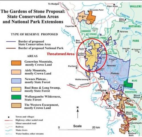 [Source: ^http://www.bluemountains.org.au/gos2.shtml] [Source: ^http://www.bluemountains.org.au/gos2.shtml]
‘These unprotected areas are just as valuable as the existing park, and are rich in special environments such as pagodas and canyons, nationally endangered high altitude shrub swamps and an unusual heathland on Genowlan Mountain. Rare and threatened species include the beautiful yellow Pagoda Daisy, Deane’s Boronia, Blue Mountains Water Skink, Wolgan Snow Gum, Giant Dragonfly, Regent Honeyeater, Genowlan Pea and Beautiful Firetail. In the western parts of the area the moist mountain vegetation begins to give way to drier inland communities, including grassy box woodlands, one of the most diminished and threatened environments in Australia.
‘The Gardens of Stone Stage 2 provides one of the most beautiful displays of sandstone geodiversity in Australia, comprising dramatically coloured sandstone escarpments and promontories, narrow canyons, cave overhangs, swamps and the complex arrays of rock pinnacles known as pagodas. The area has one of the Blue Mountains’ areas of highest plant diversity including ancient windswept montane heathlands, nationally endangered upland swamps, a unique species of snowgum (E. gregsoniana) and other high plateau woodlands representing the highest development of native vegetation on Sydney Basin sedimentary rocks, poorly conserved grassy white box woodlands on slopes below the sandstone, fascinating oil shale mining ruins on spectacular Airly Mesa, and outstanding Aboriginal cultural sites on and around Newnes Plateau.
") Gardens of Stone
© Photo by Hamilton Lund, Tourism NSW
Blue Mountains – Visit NSW, ^http://www.visitnsw.com/destinations/blue-mountains (click photo to enlarge) Gardens of Stone
© Photo by Hamilton Lund, Tourism NSW
Blue Mountains – Visit NSW, ^http://www.visitnsw.com/destinations/blue-mountains (click photo to enlarge)
.
The area embraces the last unprotected part of the 1934 Greater Blue Mountains National Park proposal compiled by Myles Dunphy for the National Parks and Primitive Areas Council. It also includes the Blue Mountains Western Escarpment lands from Blackheath to Lithgow. The Gardens of Stone Stage 2 proposal advanced by The Colong Foundation for Wilderness, the Blue Mountains Conservation Society and the Colo Committee is to include all of the remaining parts of Newnes Plateau and surrounding sandstone uplands – an area of 40,000 hectares. It would protect the most spectacular pagoda landscapes in Australia.
Associated with these pagoda landforms are found large caves, mazes, ancient montane heathlands, endangered upland swamps, snowgums, grassy woodlands and moist gullies that contain tree ferns, stands of old growth forest and rainforest, and, in some places, slot canyons.
Reservation of Stage Two would also secure the outstanding ochre coloured cliffs of the Blue Mountains’ Western Escarpment and the rare plant communities that lie above them. Reservation of the remaining unprotected parts of the Gardens of Stone as a State Conservation Area is urgently required to rein in ongoing and accelerating environmental degradation.
[Sources: Gardens of Stone National Park, http://www.worldheritage.org.au/resources/national-parks/gardens-of-stone-national-park/ and Blue Mountains Conservation Society, http://www.bluemountains.org.au/gos2.shtml]
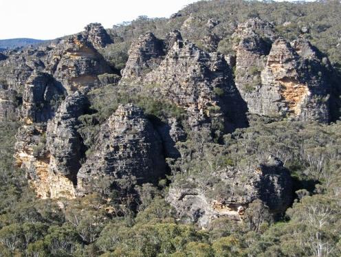 Pagodas of the Gardens of Stone (still outside the National Park) Pagodas of the Gardens of Stone (still outside the National Park)
© Photo by Andrew Valja
[Source: Blue Mountains Conservation Society, http://www.bluemountains.org.au/gos2.shtml]
(click photo to enlarge)
.
.
.

Threats from Coalpac Pty Ltd
.
CoalPac is a private Queensland coal mining company headquartered in Pullenvale in outer eastern Brisbane. In 1989, CoalPac took over coal mining operations outside the town of Lithgow in New South Wales, at the Cullen Valley Open Cut Mine and the Invincible Open Cut Mine. The Mines currently operate at 2 mtpa and Coalpac has plans for significant expansion of coal mines in the Gardens of Stone area.
 Coalpac’s CullenValley Mine
[Source: Lithgow Environment Group, Inc.]
(click photo to enlarge) Coalpac’s CullenValley Mine
[Source: Lithgow Environment Group, Inc.]
(click photo to enlarge)
.
‘Coalpac is seeking approval for the consolidation and expansion of the existing Cullen Valley Mine and Invincible Colliery operations to produce up to a total of 3.5 million tonnes per annum.’ [Source: http://cetresources.com/about-us]
This proposed extension of its open-cut and highwall mining will intrude into a large area of the publicly-owned Ben Bullen State Forest (BBSF), NSW. The extension area is equivalent of 2,176 football fields of predominantly old growth forest will be clear-felled and excavated if this goes ahead. The pagoda’s features and stability may be threatened by collapse.
 Cracked Hassans Walls, Lithgow ~ caused by nearby mining
[Source: Lithgow Environment Group, Inc.] Cracked Hassans Walls, Lithgow ~ caused by nearby mining
[Source: Lithgow Environment Group, Inc.]
.
“The NSW National Parks and Wildlife Service (now within the Office of Environment and Heritage) has acknowledged its wish to add BBSF to the conservation reserve system as a matter of priority” says Lachlan Garland, President of the Blue Mountains Conservation Society.
“Allowing this operation would mean the equivalent of 2,176 football fields of predominantly old growth forest of the BBSF being clear-felled and excavated.
“This forest is a publicly-owned area of conservation and recreational importance. The community expects state forests to be protected from destruction in perpetuity.
 ‘Baal Bone Creek’ area at risk
©Photo by Ian Brown.
‘Baal Bone and Long Swamp (7,800 hectares) comprise massed pagoda ‘villages’ above the Long Swamp, a diverse swampy plain. They collectively form an evocative landscape of broken stone, reminiscent of Cambodia’s forest of State Forest temples, while nearby indigenous cave art honours this landscape.’
(click to enlarge, then click again to enlarge further) ‘Baal Bone Creek’ area at risk
©Photo by Ian Brown.
‘Baal Bone and Long Swamp (7,800 hectares) comprise massed pagoda ‘villages’ above the Long Swamp, a diverse swampy plain. They collectively form an evocative landscape of broken stone, reminiscent of Cambodia’s forest of State Forest temples, while nearby indigenous cave art honours this landscape.’
(click to enlarge, then click again to enlarge further)
.
“Habitats for the Regent Honeyeater, Tiger Quoll and Powerful Owl and at least 32 threatened native animals, 5 of which are listed under the EPBC Act, will be completely removed.
“Our iconic Lyrebirds also use the sides of pagodas to nest and raise their young. Mining will completely remove the protective pathways for adult birds foraging between nesting sites and will destroy their food habitats within the more fertile valley floors.
“The effective privatisation and liquidation of a large part of the forest is an outrageous precedent that should not be set; it is a direct challenge to the state’s efforts to reduce deforestation.
“The Blue Mountains Conservation Society seeks to work with the Minister for the Environment and Heritage, Robyn Parker, to continue our important work and safeguard the future of the Gardens of Stone.
“We invite all politicians to visit the Gardens of Stone area with us on Sat 14th May, 2011 to see first hand the stunning areas under threat from mining.”
The NSW Department of Planning finalised the Director-General’s Requirements (guidelines) for the Environmental Assessment on 16 October 2010. The proponent is preparing the Environmental Assessment. Once finalised, this will be released for public comment. The project, prior to the election of the NSW Coalition Government, was to be assessed by an accredited process under Part 3A, which on 7th April 2011 was scrapped by the incoming O’Farrell Liberal Government of New South Wales. [read article below]
 The very yellow Pagoda Daisy (at risk)
©Photo by Ian Brown
(click to enlarge, then click again to enlarge further) The very yellow Pagoda Daisy (at risk)
©Photo by Ian Brown
(click to enlarge, then click again to enlarge further)
.
Environment groups take action to protect Gardens of Stone
The uniquely scenic and biodiverse Gardens of Stone is under imminent threat due to a consolidation proposal by Coalpac Pty Ltd. If approved, wildlife habitat and natural heritage will be lost forever, water systems will be stressed and there would be direct impacts for local residents. On Saturday 14th May, 2011 environment groups and their supporters will be taking action to help protect this iconic landscape from irredeemable destruction.
“Coalpac Pty Ltd seeks to extend open-cut and highwall mining into a large area of the publicly-owned Ben Bullen State Forest, NSW. The NSW National Parks and Wildlife Service has acknowledged its wish to add this forest to the conservation reserve system as a matter of priority” says Tara Cameron, Vice President of Blue Mountains Conservation Society.
“Many of the highwall scarps will abut strata directly below the ‘pagoda’ rock formations, their features and stability may be threatened by collapse. Environment groups are outraged at this proposal” says Tara Cameron.
“This forest is a publicly-owned area of conservation and recreational importance. The community expects state forests to be protected from destruction in perpetuity. If the NSW Government’s Strategic Regional Landuse Policy is to mean anything for sensitive, natural lands, then the Gardens of Stone must be protected from destructive mining operations, ” says Keith Muir, Director of Colong Foundation for Wilderness.
“This landscape is biodiversity hotspot, characterised by rich old-growth forests. Our iconic Lyrebirds use the sides of pagodas to nest and raise their young. Mining will completely remove their food habitats as well as the habitats of at least 32 threatened native animals” says Belinda Fairbrother, Campaigns Manager for The Wilderness Society NSW.
“Water management and impacts over such a large, exposed open-cut area are of great concern. The large open cut will also create significant dust and air quality issues which will impact directly on local residents” says Caroline Graham, Vice President of Rivers SoS.
“Environment groups are calling on the government to reject this mining proposal and act to protect the region within a State Conservation Area. We are coming together at this event to send a clear message that ‘We say No to open cut mining!’ in this iconic area of our state” says Kevin Evans, EO of National Parks Association of NSW.
“Across NSW, areas of high conservation value and great beauty are under threat from the rapid expansion of the coal and coal seam gas industries. During this time of transitional arrangements on the regulation of coal mining, the State government has an opportunity to deliver on its promise of better protection of water resources and the environment by rejecting further mining at the iconic Gardens of Stone,” says Pepe Clarke, CEO of the Nature Conservation Council of NSW.’
[Source: National Pars Association of NSW, http://www.npansw.org.au/index.php?option=com_content&view=article&id=718:environment-groups-take-action-to-protect-gardens-of-stone&catid=172:2011&Itemid=564]
.
.
‘Part 3A scrapped’
[8 Apr 11, by Tyron Butson, Southern Courier newspaper, http://southern-courier.whereilive.com.au/news/story/part-3a-scrapped/]
PREMIER Barry O’Farrell has given increased planning powers back to local councils after scrapping the controversial Part 3A amendment.
He announced the decision to drop Part 3A of the 1979 Environmental Planning and Assessment Act at yesterday’s first State Cabinet meeting.
Local councils will now have final say on many outstanding applications, while others will be referred to the NSW Planning Assessment Commission.
No new Part 3A application for residential, commercial, retail or coastal development will be accepted and the State Government hope to push through legislation that will see the amendment repealed from the Statute books when Parliament resumes.
“This means a return of planning powers to councils and local communities,” Mr O’Farrell said.
“The days of giving the Planning Minister sweeping powers to approve developments at the stroke of a pen with virtually no consultation with local communities are over.
“That extreme power only leads to the sort of suspicion and shady deals we have seen in NSW over the past 16 years.”
The scrapping of Part 3A was a core election promise of the Liberal party, but the government will still have to push legislation through the Upper House.
Mr O’Farrell said he had not attempted to convince opposition members but had directed the Minister for Planning Brad Hazzard to draw up plans.
Until then transitional arrangements will be put into place to deal with more than 500 Part 3A applications already in the system.
About half of the applications will now face the Planning Assessment Commission for assessment, while the rest will either be sent to local councils to vote on or allowed to lapse.
Part 3A was introduced in 2005 and gave planning ministers the ability to overrule local councils and communities on any project the minister deemed to be of state or regional importance.’
.
.
‘Cliffs crumbled due to coal mining, says new report’
(by Ben Cubby, Environment Editor, Sydney Morning Herald, April 27, 2010)
‘DOZENS of cliffs have crumbled or collapsed, Aboriginal rock art has been destroyed and metre-wide cracks opened in the earth as a result of coalmining in the Gardens of Stone wilderness area near Lithgow, an independent report has found.
The damage, inflicted over three decades by five coal mines and continuing today, is caused by subsidence from longwall mining, which now almost surrounds the Gardens of Stone National Park, part of the Greater Blue Mountains World Heritage Site. It is likely to be extended further if a new mine plan is approved by the NSW government.
The report, to be launched today by the former premier Bob Carr, documents wide-scale, unpublicised damage, including the destruction of some of the area’s unique sandstone pagodas and rock arches.
”In its monitoring reports to government, the coal industry regularly understates the damage caused,” said Keith Muir, the executive officer of the Colong Foundation for Wilderness, which produced the report. ”Mine operations do not work to minimise environmental damage and have been largely unresponsive to environmental concerns.”
The study based this conclusion on visual observation in the remote bushland and examination of the the environmental assessments used to justify the expansion of mining. In some cases, the assessments predicted that cliffs could crumble but no remedial action was taken.
The report looks at the six coalmines around the national park: the Angus Place, Springvale and Airly mines operated by Centennial Coal, Baal Bone and Clarence collieries operated by Coalex, and Invincible mine, operated by Coalpac. All the mining companies have met the requirements of their environmental assessment processes and have continued to monitor the impact of subsidence.
Reports produced by consultants employed by the companies showed more than 100 recorded cliff falls in the past three decades. Some led to changes in sites and techniques, but in the majority of cases the warnings were not heeded.
The damage was significantly worse above longwall mines, which cut out long, broad panels of coal, leaving the surface above to crack and subside. The Clarence and Airly mines use the bord and pillar technique, which involves leaving more coal in the ground to support the rock above, resulting in less surface damage.
Aboriginal rock art sites were also photographed with major fractures running through them and, in some cases, entire rock faces destroyed by the effects of subsidence.
”Crevasses, cliff falls and rock fractures are spoiling the sandstone beauty of the Gardens of Stone,” Mr Muir said.
The organisation is calling for a state-sanctioned conservation area that would provide a buffer zone around the park. It would cover part of the Baal Bone mine area, where a further expansion is planned, and the Newnes Plateau, where many swamps have been drained when the rock beneath them cracked open.
”The Department of Environment, Climate Change and Water has been considering proposals for additions to the Gardens of Stone National Park and an evaluation process is under way,” a spokeswoman said.
Read more: http://www.smh.com.au/environment/cliffs-crumbled-due-to-coalmining-says-new-report-20100426-tnbk.html#ixzz1MGS62mRx
.
.
Previously in 2007…

.
.
Further Reading:
.
[1] Previous article on this website: ‘Gardens of Stone at Risk from Coal Mining’, > https://www.habitatadvocate.com.au/?p=4021
[2] Blue Mountains Conservation Society, ^http://www.bluemountains.org.au/gos2.shtml
[3] Gardens of Stone National Park, ^http://www.worldheritage.org.au/resources/national-parks/gardens-of-stone-national-park/
[4] The Colong Foundation for Wilderness, ^ http://www.colongwilderness.org.au/Gardens_of_Stone/GoS2_home.htm
[5] Lithgow Environment Group, Inc. ^http://www.lithgowenvironment.org/mine_watch.html
[6] Lithgow Tourism, ^http://www.lithgow-tourism.com/gardenstone.htm
[7] Rivers SOS, ^http://riverssos.org.au/2011/04/27/help-us-protect-the-gardens-of-stone/
[8] National Parks Association of NSW, ^http://www.npansw.org.au/index.php?option=com_content&view=article&id=718:environment-groups-take-action-to-protect-gardens-of-stone&catid=172:2011&Itemid=564
[9] ‘Cliffs crumbled due to coalmining, says new report’, by Ben Cubby, Sydney Moring Herald, April 27, 2010, ^http://www.smh.com.au/environment/cliffs-crumbled-due-to-coalmining-says-new-report-20100426-tnbk.html

– end of article –
Environment groups take action to protect Gardens of Stone
The uniquely scenic and biodiverse Gardens of Stone is under imminent threat due to a consolidation proposal by Coalpac Pty Ltd. If approved, wildlife habitat and natural heritage will be lost forever, water systems will be stressed and there would be direct impacts for local residents. On Saturday 14th May, 2011 environment groups and their supporters will be taking action to help protect this iconic landscape from irredeemable destruction.
“Coalpac Pty Ltd seeks to extend open-cut and highwall mining into a large area of the publicly-owned Ben Bullen State Forest, NSW. The NSW National Parks and Wildlife Service has acknowledged its wish to add this forest to the conservation reserve system as a matter of priority” says Tara Cameron, Vice President of Blue Mountains Conservation Society.
“Many of the highwall scarps will abut strata directly below the ‘pagoda’ rock formations, their features and stability may be threatened by collapse. Environment groups are outraged at this proposal” says Tara Cameron.
“This forest is a publicly-owned area of conservation and recreational importance. The community expects state forests to be protected from destruction in perpetuity. If the NSW Government’s Strategic Regional Landuse Policy is to mean anything for sensitive, natural lands, then the Gardens of Stone must be protected from destructive mining operations, ” says Keith Muir, Director of Colong Foundation for Wilderness.
“This landscape is biodiversity hotspot, characterised by rich old-growth forests. Our iconic Lyrebirds use the sides of pagodas to nest and raise their young. Mining will completely remove their food habitats as well as the habitats of at least 32 threatened native animals” says Belinda Fairbrother, Campaigns Manager for The Wilderness Society NSW.
“Water management and impacts over such a large, exposed open-cut area are of great concern. The large open cut will also create significant dust and air quality issues which will impact directly on local residents” says Caroline Graham, Vice President of Rivers SoS.
“Environment groups are calling on the government to reject this mining proposal and act to protect the region within a State Conservation Area. We are coming together at this event to send a clear message that ‘We say No to open cut mining!’ in this iconic area of our state” says Kevin Evans, EO of National Parks Association of NSW.
“Across NSW, areas of high conservation value and great beauty are under threat from the rapid expansion of the coal and coal seam gas industries. During this time of transitional arrangements on the regulation of coal mining, the State government has an opportunity to deliver on its promise of better protection of water resources and the environment by rejecting further mining at the iconic Gardens of Stone,” says Pepe Clarke, CEO of the Nature Conservation Council of NSW.
Tags: Baal Bone, Barry O'Farrell, Ben Bullen State Forest, Blue Mountains World Heritage Area, Capertee Valley, Coal Mining, Coalpac Pty Ltd, Gardens of Stone, Genowlan Mountain, Hassans Walls, Lithgow Coal, Minister for Planning Brad Hazzard, Minister for the Environment and Heritage Robyn Parker, Newnes Plateau, Pantoneys Crown, Part 3A, Powerful Owl, Regent Honeyeater, Tiger Quoll, Wolgan Valley
Posted in Blue Mountains (AU), Threats from Mining | No Comments »
Add this post to Del.icio.us - Digg
|
|

")
") .
.")


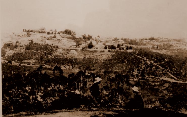


")


")

")


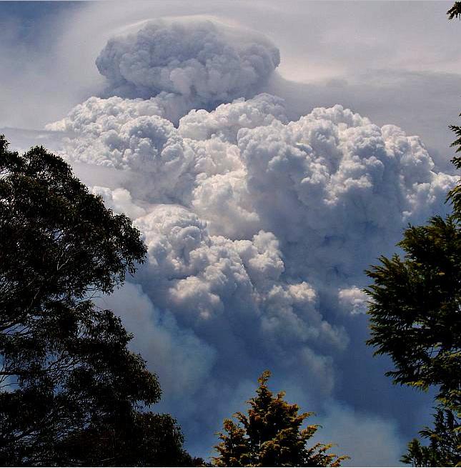
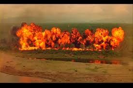