Residents of the Blue Mountains, Maureen and Peter Toy, were shocked to learn last month about an arbitrary claim for this magnificent tree (pictured) to be killed for what they consider can be no rational reason.
According to advice that the Toys received from local conservation consultancy The Habitat Advocate, this large Blue Mountains Ash (Eucalyptus oreades) is a native tree only found in the Upper Blue Mountains. This particular specimen probably dates to 19th Century colonial settlement in Australia.
Maureen says “It is a beautiful and rare specimen and Blue Mountains folk are fortunate that we have such a significant tree still growing right by Megalong Street in now an increasingly industrialised part of Katoomba.”
Over the many decades, this great tree has withstood fierce windstorms, bushfires, road-widening right up to its trunk and industrial development all around it. With a canopy about 40 metres high and a trunk girth of over 5 metres, the tree has become a recognised icon and reference point in the area. It is home to a flock of sulphur-crested cockatoos.
Maureen affectionately calls the tree, ‘Atlas’, after the Greek God, for its towering size and for being so enduring. There is no other quite like it perhaps throughout the world renown Blue Mountains World Heritage Area.
Peter can’t understand why the tree is not on Council’s Significant Tree Register or why anyone would want to harm it. The tree is on community verge land and for the past few years there has been an industrial development constructed behind it. Peter and Maureen are vehemently opposed to any further harm being inflicted upon the tree and they have lodged a protest with council.
Several others in the local community have sided with the Toys and together have formed a local group ‘Friends of Atlas’ determined to protect the tree. Peter is looking to start a petition to garner local community recognition and support to protect the tree. He says “it is early days but he is ready for a sustained fight.”
A spokesperson from Blue Mountains (city?) Council has confirmed that the tree is situated on ‘Community Land‘ on the verdant verge strip between the street and the new industrial development at number 59 Megalong Street. The tree and its canopy and root system is not on private land, but on Community Land. Council has a duty as the community-delegated custodian of all community lands throughout the Blue Mountains Local Government Area. Council does not ‘own’ the tree per se, rather Council acts as the responsible custodian of this significant tree.
Council has stipulated in its development consent conditions for the adjoining industrial development application since 2010 that the tree must not be harmed by the current development activity.
But Peter disagrees. He says “guttering has been dug right into the tree roots system and just a month ago the developer had a bobcat grade the topsoil and roots around the tree for an entire day!.”
Council’s spokesperson says that council has not received any request for the tree to be destroyed.
<<The Greater Blue Mountains World Heritage Area only exists today because of a 70-year campaign by conservationists to achieve a chain of reserves across the region. This culminated in the year 2000 with the acceptance of 10,000 square kilometres of wild bushland onto the World Heritage list – the ‘best of the best’.>>
Why did three wildfires start today in north western Sydney in protected reserves of Sydney’s remnant Cumberland Plains Woodland?
The fires all started around midday during high gusty wind conditions and unseasonally high temperatures. There was no lightning to speak of, so all three fires must have been caused by people.
Reckless burnoffs? Deliberately lit? By the same people? By developers wanting to undermine the Cumberland Plain Woodland and so extend their sprawl?
Whether it was bush arson or recklessness will be a matter for bushfire investigations which need to be mandatory for each and every wildfire. A forth wildfire at Winmalee in the nearby Blue Mountains (the ‘Hawkesbury Road Winmalee Fire‘) was purportedly a neglected hazard reduction burn – the Rural Fire Starters fuelling more work for themselves.
What did each wildfire cost – economic loss, infrastructure loss, productivity loss, direct firefighting costs, indirect costs, social costs? These are never measured or reported. The ecological costs are always ignored because ecology is not deemed to be valuable in our current society. How much death and harm has been infliced upon Windsor Downs Nature Reserve? Such value questions are beyond the thinking of our current society.
The RFS only prioritises saving human life and property. It thus has no different role than the NSW Fire Brigade. So the RFS should not exist. It only exists because the New South Wales government does not want to properly pay for firefighting. The RFS exists as unpaid volunteers so that the NSW government can divert hundreds of millions in taxes to other priorities it somehow considers to be more important.
Then the NSW government appeals for more volunteers to do its dirty work for free.
.
Whereas in New South Wales, a NSW Fire Brigage professional firefighter gets paid $29 an hour minimum. There will be many families that would dearly desire to receive that for their unpaid volunteering efforts.
“At Richmond Road and Bennett Road at Windsor, the RFS (New South Wales Rural Fire Service) says a grassfire could impact properties around George Street and the area of Bligh Park. The fire has crossed Garfield Road and is burning in the Windsor Downs Nature Reserve.”
The fire authorities have labelled this current fire the ‘Richmond Road Grass Fire‘, so will the records of the fire will be just scattered or erased? Today’s initial account of the fire on the official Rural Fire Service website reads thus :
“..A grass fire burning in the area of Richmond Road and Bennett Road at Windsor”. The fire is burning on both sides of George Street, South Windsor and both sides of Richmond Road. The fire is burning under strong northerly winds. An Emergency Alert telephone message has been sent to residents in these areas.
There is the potential for the fire to impact on properties around George Street and the area of Bligh Park. The fire has crossed Richmond Road and is now burning in the Windsor Downs Nature Reserve.”
.
To put this into geographic perspective, this is a presumed map of the affected area, in absence of RFS public transparency:
The presumed ignition of the Richmond Road Grass Fire from Bennett Road, Windsor Downs
(outer north-western Sydney Metropolis)
[Source: Google Maps 2013]
.
<<Emergency warnings have now been issued for four bushfires in Sydney’s far north west, as temperatures in the city exceed 30 degrees with strong northerly winds.
The RFS says five firefighters have sustained smoke inhalation and two have received minor burns.
The fires are at Castlereagh, Richmond, Marsden Park, and Winmalee where one property is alight. At Richmond Road and Bennett Road at Windsor, RFS says a grassfire could impact properties around George Street and the area of Bligh Park. The fire has crossed Garfield Road and is burning in the Windsor Downs Nature Reserve. >>
.
[Ed: Garfield Road is in Riverstone, not Richmond, and is also quite distinct from the separate fire at Windsor Downs. Media reporting has been misleadingly false, overlapping and confused and likely due to naive junior desktop journalism. Worse is that the RFS report is equally confused. Fortunately no person died relying upon officialdom, but the wildlife count is never published].
.
.Map showing the juxtaposition of the Windsor Downs Nature Reserve over 3 km north west from Garfield Road in Riverstone.Journalists have a lot to answer for when it comes to fact checking during emergencies.
[Source: Google Maps 2013, click image to enlarge]
.
<< About 3,200 homes in the Richmond area have lost power and Endeavour Energy says it is working to get the supply back. The RFS says the fire is burning intensely under strong winds.
In Marsden Park, a grass fire is burning out of control and has crossed Garfield Road. While at Castlereagh, near Penrith, an emergency warning was issued around noon (AEST) for a fire which has destroyed a shed and burned 60 hectares. About 50 homes are thought to be under threat. The fire is burning around properties on Devlin Road and is moving towards homes on Nutt Road.
RFS Inspector Ben Shepherd says the conditions are difficult for firefighters.
RFS Inspector Ben Shepherd:
“I’m currently sitting on Nutt Road and the fire is moving quickly towards some homes in that area. The actual fire itself is putting up a huge column of smoke… and the wind continues to be quite strong. Because of that, that’s starting to send a couple of spot fires ahead of the main fire front itself.”
.
Local resident Kelly Elson has been evacuated from her home near the fire front. She says she first noticed the fire at about 10:30 this morning.
Windsor resident Troy Evans says that fire started in grass near his house on Bennett Road.
Windsor resident Troy Evans:
“So I went and told the firies ‘you better get a couple of trucks round here real quick’ which they did, luckily. They got the place under control then the wind turned and it’s just roared up through next door, jumped the road, it’s gone through the church, it’s over in the bus bay, it’s meant to have taken a couple of houses out in Bligh Park. Now it’s on it’s way into the jail, it’s just crazy.”
.
A very high fire danger alert has been issued for the Illawarra, Sydney, the Central Ranges, the Hunter, the north west and the north coast. More than 40 uncontained bushfires are currently burning across New South Wales.
Mr (RFS Commissioner Shane) Fitzsimmons says it is hot, dry and windy in most of the state today, with seven districts in very high fire danger. He says he is worried about the unseasonally warm start to spring on the back of a dry winter.
The RFS is urging property owners in semi-rural and rural areas to think about the conditions before they burn off land.”
.
[Ed: Fitzsimmons, why blame the weather and not the landholder who is accused of causing the ignition?]
[Ed: So theRFS is urging property owners in semi-rural and rural areas to think about the conditions before they burn off land.
Is this head office code for the known landholder who caused the fire and the RFS being too public servant skin timid to lay charges? So why is the landholder in Bennett Road not under arrest for suspected arson?]
.
The fire inside the Windsor Downs Nature Reserve today
Cumberland Plain Woodland including the Windsor Downs Nature Reserve, the nearby Castlereagh Nature Reserve and Agnes Banks Nature Reserve, all fall under the custodial management responsibility of the National Parks and Wildlife Service New South Wales – a state body.
Windsor Downs Nature Reserve features.. << an historic windmill and water tank protects a number of endangered plant communities and includes species such as the broad-leafed ironbark, grey box, scribbly gum, narrow-leafed angophora, pea flowers and a species of geebung.
Several bird species have been recorded – the red-capped and hooded robins, white-winged choughs, buff-rumped and yellow-tailed thornbills and the endangered regent honeyeater – which are usually found in the drier habitats of the central west slopes. >>
Windsor Downs Nature Reserve is not just set aside for picnics. It is a remant ecological community with the fast disappearing Cumberland Plain Woodland. It is supposed to be protected.
.
<< The Cumberland Plain Woodland is the name for the distinct groupings of plants that occur on the clay soils derived from shale on the undulating Cumberland Plain in central New South Wales. The most commonly found trees in the woodland are Grey Box Eucalypts Eucalyptus moluccana, Forest Red Gums Eucalyptus tereticornis, Narrow-Leaved Ironbarks Eucalyptus crebra and Spotted Gum Eucalyptus maculata. A variety of other lesser-known eucalypts as well as shrubs, grasses and herbs are also found. It is the dominance of Grey Box and Forest Red Gum that makes the community distinctive.
In 1877 Cumberland Plain Woodland covered 107,000 hectares occupying approximately 30 per cent of the Sydney Basin. This community type was once widespread in the Plains but has been reduced to a few fragmented stands by human use for farming, industry and housing. Today less than six per cent remains in small fragments scattered across the western suburbs of Sydney, totalling only 6400 hectares. The remaining fragments occur in areas subject to intense pressure from urban development.
Although some areas occur within conservation reserves, this is in itself not sufficient to ensure the long-term survival of the community unless the factors threatening the integrity and survival of the community are eliminated.
The remaining stands of this ecological community are threatened by the spread of the Sydney suburban areas. Threats include clearance for agriculture, grazing, hobby and poultry farming, housing and other developments, invasion by exotic plants and increased nutrient loads due to fertiliser run-off from gardens and farmland, dumped refuse or sewer discharge.>>
[Ed: and of course ‘bushfire’, which the government does not like to include out of embarassment of neglect, yet which is causes the most devastating impact].
Cumberland Plain Woodland in the Sydney Basin Bioregion – proposed critically endangered ecological community listing
.
<< The NSW Scientific Committee, established by the Threatened Species Conservation Act, has made a Preliminary Determination to support a proposal to list the Cumberland Plain Woodland in the Sydney Basin Bioregion as a CRITICALLY ENDANGERED ECOLOGICAL COMMUNITY on Part 2 of Schedule 1A of the Act and as a consequence, to omit reference to Cumberland Plain Woodland from Part 3 of Schedule 1 (Endangered Ecological Communities) of the Act. The listing of Critically Endangered Ecological Communities is provided for by Part 2 of the Act.
The Scientific Committee has found that:
1. Cumberland Plain Woodland was listed as an Endangered Ecological Community under the Threatened Species Conservation Act 1995 in June 1997 (NSW Scientific Committee 1997). Since this listing, a large volume of new data and analyses have become available. In addition, a nomination to change the status of Cumberland Woodland to Critically Endangered status has been received. This Determination addresses additional information now available in accordance with current listing criteria under the Threatened Species Conservation Regulation 2002.
2. Cumberland Plain Woodland is the name given to the ecological community in the Sydney Basin bioregion associated with clay soils derived from Wianamatta Group geology, or more rarely alluvial substrates, on the Cumberland Plain, a rainshadow area to the west of Sydney’s Central Business District. >>
<<..high frequencies of fires may result where fragmentation increases the interface between urban areas and bushland, as this results in increased arson, car dumping, planned fuel-reduction fires and accidental ignitions.
High fire frequencies are associated with reduced diversity of native plant species in Cumberland Plain Woodland (Watson 2005). ‘High frequency fire resulting in disruption of life cycle processes in plants and animals and loss of vegetation structure and composition’ is listed as a Key Threatening Process under the Threatened Species Conservation Act 1995.
The season of fire, which may be altered as a consequence of hazard reduction fires, may also influence the species composition of the grassy woodland understorey (Knox & Clarke 2006; Benson & von Richter 2008).
Disruption of ecological processes associated with alteration of fire regimes contributes to a very large reduction in ecological function of the community. >>
The official Fire Management Strategy has been conveniently removed from public access on the National Parks and Wildlife Service (NPWS) website.
However, the following extracts from the similar and nearby Agnes Banks Nature Reserve are instructive as to the approach taken by NPWS management on all nature reserves across the Sydney Basin that comprise remnant ecology of the Cumberland Plain Woodland.
[Ed: Disturbingly noted is that the NPWS ‘ecological’ policy is that it ok to burn these woodland reserves every 8 years. So government care factor about bushfire impact?]
.
<<..little research has been undertaken into fire management prescriptions for Cumberland Plain woodland and forest associations when compared to the nearby Hawkesbury sandstone communities.>>
~ Windsor Downs Nature Reserve et al. Plan of Management (NPWS 1999,p.18)
.
The official Bureau of Meteorology had in the days prior, forecast strong gusty north westerly winds for the western Sydney region for both yesterday and today, following a few days of calm winds. The Rural Fire Service would have been well aware of this forecast, the extreme bushfire conditions that this posed and the considerable escalated risk of damaging wildlfires.
The subsequent actual weather observations for Richmond are telling. Look at the 10th. The arsonists know what they are doing.
Reliant mainly on public calls to ‘000’, fire trucks and road-routed volunteers, the RFS continues to be grossly under-equipped to handle wildlfires in a timely and effective manner, which increasingly to many is unacceptable to bushfire prone communities in this now 21st Century.
Steadily year on year, the last bushland reserves that provide critical remnant habitat around Sydney are being destroyed. Before long the only bushland will be that in suburban gardens, and the wildlife will be finally made regionally extinct.
.
Critically Endangered Regent Honeyeater
(Anthochaera phrygia)
A native bird species dependant upon a disappearing habitat
Humans obliterated its habitat for logging, farming and housing
Then we constrained it to a few nature reserves like Windsor Downs,
Then we burnt the reserve.
<<Authorities say they believe a fire that destroyed a home at Marsden Park in Sydney’s west on Tuesday was deliberately lit. Investigators have also not ruled out that an arsonist may have caused a blaze at nearby Londonderry. Police are now calling for witnesses to help identify the person responsible for sparking the Marsden Park fire.
Assistant Commissioner Alan Clarke says it is believed the fire began on Grange Avenue just after midday on Tuesday.
.
Alan Clarke:
. “There are crime scene indicators at the source of that fire that would lead us to suspect arson activity. I really can’t tell you more than that at the moment. It’s mainly our crime scene indicators and forensic evidence that would have us raise that suspicion. If anyone has information, if anyone saw any suspicious activity in or around that fire location, any part of it… please pass that information on for the benefit of police.”
.
Rural Fire Service Deputy Commissioner Rob Rogers has confirmed another serious fire at Winmalee, in the lower Blue Mountains, was caused by a hazard reduction burn conducted by the NSW National Parks and Wildlife Service.
.
Rob Rogers:
“That fire was burn on the weekend, it was patrolled on Monday, there was smouldering activity. That fire then jumped containment lines on the Tuesday and became an active fire. The winds on that day did exceed forecast and they were around 90 kilometres an hour, and obviously that tested the control lines on that hazard reduction and it did escape. In these strong winds branches came off trees, hit the powerlines, the powerlines were brought down, they ignited grass in that area and that was the cause of that fire. You would have to obviously be suspicious that it did come from the hazard reduction, given that it was in a very close proximity to it.”
.
Investigators have found a fourth fire that began on Richmond Road at Windsor Downs was sparked by downed power lines. The investigation into a fire that closed the M1 motorway, formerly known as the F3, north of Sydney yesterday is continuing, with another hazard reduction burn the suspected cause. Assistant Commissioner Alan Clarke has warned those that deliberately light fires or cause them through negligence will be caught.
.
Alan Clarke:
“Last year we arrested 87 individuals and they faced charges in respect of bushfire and fire related activity for 117 charges. We know this year again we will be putting offenders before the court. It’s sad but it’s true.”
Crimson Rosella in snow, a native to The Gully
(Platycercus elegans)
(Photo by Editor, 20121012, free in public domain, click image to enlarge)
.
It rarely snows in Katoomba in the Blue Mountains these days. In the old days it used to snow every winter, but these days we are lucky to get a brief flurry in August that doesn’t even settle.
So this morning was exceptional. The forecast today (Friday) was for a storm further south, but at 6am in Katoomba it started snowing. And in the middle of October (spring)!
Then it kept snowing and kept snowing ‘ till after 1pm. A few big tree branches crashed under the weight of snow. The streets and roads steadily became blanketed in snow, making them slippery and dangerous to most vehicles. The Great Western Highway remains closed. The trains are snowbound up at Mount Vic. It’s like we’re in the Alps where snow there is normal, but here no-one was ready for it. Snow has regrettably become a freak event in the Blue Mountains.
We must have received about half a foot of snow by lunchtime. Everything became soft white in a black and white landscape.
So it became quite a special morning and well worth a walk around The Gully in the snow.
.
The Gully in Snow
(Photo by Editor, 20121012, free in public domain, click image to enlarge)
.
(Click play, then click full screen icon at bottom right of video)
.
Streets around The Gully in Snow
(Photo by Editor, 20121012, free in public domain, click image to enlarge)
.
Tyre tracks through the snow in Katoomba
(Photo by Editor, 20121012, free in public domain, click image to enlarge)
Australia’s tradition of the ‘Wood Fire’ is ecologically destructive
.
During Australia’s winter months, many in older homes habitually yearn for the warmth and glow of a traditional Wood Fire, and so utilise their open fire places and wood heaters. So habitually, upon the onset of winter people stock up on Firewood. It is a cultural yearning for the nostalgia of the Wood Fire – warm, earthy, dancing flames, flickering, spark spitting, the woodsmoke – we’ve all been there, it is tantalising and it feels right because it is natural – the ancient campfire tradition across humanity. In doing the Wood Fire ritual, we seek to rekindle our connection to Nature.
The warmth and glow of a traditional Open Fire
…but the demand is driving deforestation of Ironbark Forests
.
In earlier times when a few hundred of us settled in a given forest region, few forest resources were taken and so the forests replenished and seemed to cope. The forests were naturally resilient.
But as subsequent human hoards have invaded the land, and have bred and sprawled across the countryside in the hundreds of thousands, we have deforested entire forests in the process. These forests haven’t coped with the devastation. No forest could cope.
Australia’s native forests have been hacked, logged, burned and bulldozed into agrarian pasture to the horizon. Australia’s original blanket vegetation cover has been reduced to sad islands barely able to support wildlife habitat and in many cases causing extinctions – locally, regionally and nationally. All one needs do is a Google Earth search to appreciate the devastation on the natural landscape.
A legacy of forestry
.
Humanity’s sheer numbers and the encouraged consumption rate of Australians risk exacerbating the deforestation. Contemporary Australia is simply extending and perpetuating the old colonial exploitive mindset and a lifestyle reminiscent of 19th Century invading colonists.
The cultural heritage of the Wood Fire is necessarily contributing to this deforestation, particularly to Australia’s native Box-Ironbark Forests.
For Australians to continue to yearn for the glow, warmth and woodsmoke of the traditional Wood Fire now that we number in the hundreds of thousands, if not millions, and so the aggregate consumption of timber for firewood has simply become unsustainable. Our native forests have become too small and disparate to sustain wildlife breeding.
The few shrinking native forests that our forebears and their frenzied clearing have left us, simply are disappearing. Australia’s remnant native forests continue to be destroyed by us just to serve this selfish cultural yearning for earthy nostalgia of the Wood Fire. The same applies to all woodheaters.
A classic wood fire in an old style open fireplace
.
The Australian Wood Fire cultural imperative through winter has become a driver of forest extinctions. There have become too many of us wanting tonnes of the forest to burn in our open fires and wood heaters, and too few forests left.
Australia’s firewood demand is driving deforestation. There is estimated to be around 800,000 wood heaters and 700,000 open fire places in Australia (ANZECC, 2001). There combined use is unsustainable and has got to stop! We need to question this inherited and habitual Open Fire/Woodheater culture and the devastating impact it is causing to our native forests.
.
“One of the hidden environmental issues affecting Australia’s woodlands, the collection of firewood, is starting to be revealed. CSIRO has prepared a report, Impact and Use of Firewood in Australia, pointing out alarming environmental problems. For example, up to 6 million tonnes of fuelwood is consumed in Australia each year – double the amount of annual exports of eucalypt woodchips!”
Firewood taken from a native forest for personal use is one thing. The scale and severity of adverse impact upon forest ecology will vary according to the amount taken and the ecological sensitivity of the place it is taken from. Few domestic takers of firewood will be qualified ecologists and so will have no or little comprehension or respect for such impacts.
A private firewood stack
.
According to the CSIRO, up to 5.5 million tonnes of timber is harvested annually for Australian domestic firewood use. When industrial firewood use is included, the total amount rises 20% to between 6-7 million tonnes. This weight is roughly double the amount of eucalypt currently exported annually from Australia as woodchips. About half of all domestic firewood is collected by the consumer and 84% of domestic firewood is collected on private property. [CSIRO, 2000]
Across Australia, access to State Forests is unfettered and the collecting of firewood for personal (domestic) consumption is an uncontrolled free-for-all, little improved from the exploitative mindset of Australia’s early and more ignorant colonists.
Australian colonial ‘progress’
.
Deforestation by firewood taking is perhaps not as broadscale and well known as the Conservation Movement’s exposure of state-sanctioned Industrial Logging by the likes of Australian state government departments:
‘VicForests‘ (Victoria)
‘Forests NSW‘ (New South Wales)
‘Forestry SA‘ (South Australia)
‘Forestry Tasmania‘ (Tasmania)
‘Forests and Wood‘ (Queensland)
‘Forests Products Commission‘ (West Australia)
.
Or is it?
It is Australia’s Commercial Firewood Industry that contributes to the demise of Australia’s remnant native forests by its ‘death by a thousand cuts‘. Commercial Firewood entails the direct taking of wood from Australia’s native forests for commercial sale and profit. It is of a scale far greater than domestic forewood collecting, but where are the statistics kept and publicised by the Australian Government?
Just as demand for firewood drive supply, the artificial low economic cost of firewood encourages demand volume. Since firewood is sold a low cost, it competes favourably with jalternatiuve sources of fuel, such as gas and electricity, for domestic heating. Commercial firewood suppliers also deliberately appeal to the Wood Fire cultural image to encourage their firewood sales. Suppliers and consusmers thus feed off each other at low cost and high volumes, and so more native forests lose out.
A commercial firewood stack
.
The low or no cost availability of timber from State Forests Native timber means that the industry operates on an industrial scale taking vast quantities of timber, particularly from the preferred hardwood Box-Ironbark Forests and the like. The Commerical Firewood Industry is encouraged by the Australian Government and by all state governments, which ignore the practice as if Australia’s natuve forests are unlimited, as if it had no adverse ecological impact upon the forest ecologies, as if it didn’t matter, as if there were no tomorrow.
Commercial Firewood Production
Norwegian Hakki-Pilke industrial machinery enables an industrial scale operation
[Source: Mascus Australia, ^http://www.mascus.com.au/]
.
Across Australia, each state government issues cheap permits for collecting firewood from State Forests.
This reflects:
A cultural disregard for the values of Australia’s disappearing forest ecologies up to Prime Ministerial and Cabinet level
The inadequacies of State laws to protect forest ecology
An antiquainted colonist mindset persisting throughout the dominating Liberal and Labor parties.
.
The ecological impacts and the plethora of ecological advice and warnings about the destructive impacts of logging on forest ecology are being ignored. Australia’s Commercial Firewood Industry fuels demand for cheap firewood and in the process exacerbates Australia’s deforestation.
Australia’s Firewood Industry is unsustainable and has got to be nationally controlled. We need to challenge this exploitative industry and correct ignorant government policies. We need to find alternatives to the Wood Fire to stem the devastation of Australia’s remaining native forests and to help prevent more wildlife extinctions.
.
‘Forest Eco-theft’ involves the immoral taking of timber from a native forest, especially in large industrial quantities, for commercial gain and incurring no or little economic cost to the taker. The intended or actual use of the timber is irrelevent, but may include logs, firewood, craft timber, or woodchips. The greater the timber volume taken, the greater impact upon a forest and so the more serious the Eco-theft.
.
‘Eco-theft’ is only different to criminal theft because of the colonist exploitative mindset of current governments rejecting native forest having ecological value worthy of protection under the Crimes Act.
.
An industrial scale Hakki-Pilke firewood processor from Norway
.
Forest Eco-theft in an environment of dwindling forest habitat has become a key threatening process. At the current rate of Forest Eco-theft, Australia’s native forests fueling our pleasure for earthy glows and hearth warmth, will be gone.
Firewood Logging simply destroys forest habitat and contributes to the demise and local extinctions of threatened and endangered wildlife. Australia’s flora and fauna deaths and ultimate extinctions has become infamy – Australia currently has the worst record of mammalian extinctions on the planet, and the Firewood culture is contributing to it.
Many consumers of firewood either actively couldn’t care, or else passively turn an insular blind eye to the adverse ecological impacts of firewood harvesting. Our Australian Government ignores the firewood deforestation problem, avoiding it for party political convenience – immorally, irresponsibly and unrepresentingly.
Just as Poaching Wildlife is immoral, so too is Forest Eco-theft. Both these exploitative practices hark to colonial times and need to be banned.
Firewood Logging of State Forest near Taralga NSW in 2006.
(along the Goulbourn-Oberon Road, just west of the Blue Mountains)
“This is in the habitat of Diuris aequalis. Had a fair result after two visits to this site and three submissions to local Council. Department of Environment and Conservation have imposed rigid conditions on this business.”
[Source: ‘Habitat – Protection or Destruction‘, 2006, by Alan W Stephenson, Conservation Director, Australian Orchid Council Inc.
^http://www.orchidsaustralia.com/article_%20conservation_no3.htm]
.
.
Why choose ‘Ironbark Firewood’ ?
.
Why choose Ironbark Firewood ? Why not choose an alternative sources of fuel for home heating? Never thought to question the legitimacy of your fuel?
Here’s the justification by one firewood supplier as to why one should choose Ironbark Firewood:
‘Long Burning. Harder to start but will burn 6 – 8 hours. These timbers are the slowest growing and the hardest of all hardwoods.’
‘Very little ash. Clean out fire only once per season approximately.’
‘Strong Burning. Cannot be put out even if the vent closed, unless water is used.’
A classic Ironbark ‘Open Fire’
.
The most common type of firewood commerically sold and promoted in the eastern Australian states is Ironbark Firewood. This is typically sourced from Box-Ironbark Forests (native grassy woodlands).
According to the Firewood Association of Australia (FAA), Ironbark and Box are the preferred firewood in Queensland, while in Victoria, southern NSW and South Australia, River Red Gum is preferred. Jarrah and Wandoo hardwood timbers are preferred in Western Australia, while in Tasmania, Brown Peppermint is considered the best firewood.
Sydney’s Firewood has been linked to ongoing Queensland land clearing, and in Queensland successive backward state governments have an ignoble reputation for land clearing like there’s no tomorrow.
Landclearing in Queensland has become the major supplier of Sydney’s quality firewood. Most of Sydney’s big firewood companies now rely on the Sunshine State for a significant proportion of ironbark and box logs – highly sought-after timbers because of their density. The National Parks Association says firewood from endangered Queensland woodlands is being used in homes across New South Wales.
Back in 2001, the National Parks Association of NSW called on the NSW Government to limit the State’s use of firewood following revelations that most of the wood sold by Sydney’s big firewood companies comes from clearing of Queenslands threatened Ironbark and Box woodlands.
Ironbark Woodland of Central Queensland
[Australia Natural Resource Atlas]
.
At the time, Mr Charlie Spiteri, the owner of Betta Burn Firewood, one of the biggest suppliers in Sydney, refused to reveal how much firewood he supplies each year but estimates that the Sydney region, including Katoomba, consumes about 100,000 tonnes.
Commercial Firewood stockpile
(click photo to enlarge)
.
Spiteri said about a third of his supply was sourced from Queensland, where the wood is worth between $40 and $50 a cubic metre. By the time the freight reaches Sydney, it is worth up to $125 and is being snapped up. “People are choosing ironbark and box and we have to go where the timber is,” Mr Spiteri said.
Other major sources of hardwoods for Betta Burn include the Pilliga State Forest in north-west NSW and private properties in the Nyngan area.
Executive officer at the National Parks Association (NSW), Mr Andrew Cox, said:
“Firewood collecting is the second largest threat to Australia’s temperate woodlands after land clearing. Now its being linked to landclearing!” “We know little about the impacts of firewood collecting and governments have been slow to take an interest. Most firewood consumers are unaware of where their wood comes from or the huge impact it has on threatened animals, birds and reptiles.”
“The firewood industry is large, but mostly unknown”, said Andrew Cox, NPA Executive Officer. “About 1,500,000 tonnes of firewood are used by New South Wales each year, exceeding the State’s yearly combined production of sawlogs and woodchips.”
“Firewood collecting targets slow-growing ecosystems and some of their most important components. Eucalypt species such as ironbark, box and red gum are the most favoured firewood sources.”
“We need to move away from the need to ‘clean-up’ a forest or woodland and instead look at dead wood as an important ecological component – just as important as the living trees.”
“Its because we’re not properly managing the woodlands that a wave of bird extinctions is underway in central NSW. More than 20 woodland dependent birds are declining from their former range and may become extinct in NSW. “It’s not ecologically sound, it’s not sustainable and there are serious impacts on birds, on animals that depend on the hollows.”
But no-one knows for sure how much timber salvaged from the bulldozed woodlands of Queensland is making its way south of the border in convoys of semi-trailers. Firewood collection operates in a legal vacuum – especially on private land – and virtually no figures are kept for where wood is sourced or how it is collected.
[Source: ‘Sydney’s Firewood Linked to Queensland Land Clearing‘, by Andrew Cox, Executive Officer, National Parks Association of NSW, 20010428, ^http://dazed.org/npa/press/20010428firewood.htm]
A typical commercial firewood truck – 2 tonne?
.
Since then, over a decade ago, what has changed? Anything? Nothing? Has the problem gotten worse?
.
83% of the original Box-Ironbark Forests have gone
In Victoria, few forest and woodland ecosystems are as poorly represented in parks and reserves as the distinctive Box-Ironbark ecosystems of northern Victoria.
Since European settlement these forests and woodlands have been extensively cleared and fragmented for agriculture, urban development and gold mining, and cut for a variety of wood products. They once covered three million hectares of northern Victoria, but 83% of the original Box-Ironbark vegetation has now been cleared.
Original distribution of grassy woodlands across New South Wales
(Dominated by Box-Ironbark Forests)
.
Not only have the forests and woodlands been mostly cleared, but what is left is highly modified from its original structure and is also very fragmented. These remaining forests and woodlands are mostly on public land and these areas are ecologically important for a rich diversity of flora and fauna, many of which are rare or threatened.
Box-Ironbark forests and woodlands are highly accessible and the visitor is rewarded by a vibrant array of bird species, carpets of wildflowers in Spring, the rich aroma of eucalypt nectar, and many sites of historical and cultural interest. Despite their apparent uniformity, these forests actually have great diversity with around 1 500 species of higher plants and over 250 vertebrate species recorded in the region; many are largely restricted to Box-Ironbark forests and woodlands.
Some 297 Box-Ironbark plant species and 53 animal species are now classified as extinct, threatened or near-threatened. In addition, at least ten plant and animal species are known to have disappeared from the study area since the 1840s, and numerous others have become locally extinct. It is also clear and of great concern that many species, particularly birds, are known to be still declining.
Accordingly, a key feature of Box-Ironbark nature conservation is the promotion of ‘recovery’ for many species, rather than simply maintaining the status quo. Many Australian animals are dependent upon large, old eucalypt trees which contain the hollows required for shelter and breeding. At least six of the threatened Box-Ironbark fauna species are strongly dependent upon these trees. The massive loss of large old trees over the last 150 years is strongly implicated in the decline of these species and perhaps many others. It is therefore recommended that as well as protecting existing large old trees, additional measures be taken to ensure that there will, over time, be more large old trees in the forests.
Ironbark is a preferred firewood in eastern Australia because it burns longer and hotter, so Australia’s native Ironbark forests continue to be logged for firewood.
Ironbark firewood stack, commercially cut and split ready for domestic delivery
.
The Australian hardwood timber industry now mainly relies upon plantation timbers and sustainable forestry management practices. Australian Ironbark Flooring retails at a premium price at typically over $80/m2 at 19mm thick. If that square meter of flooring was stacked one metre high to achieve a cubic metre, the calculated retail price for a cubic metre would be (1000m/19mm = 50 layers of flooring roughly, making the retail price for a cubic metre of Ironbark flooring around $80 x 50 = $5600/m3!
Expensive Ironbark Flooring
Sourced from sustainable plantation timber, unaffordable to the Commercial Firewood Industry,
so firewood suppliers take the Ironbark out of State Forests instead.
[Source: Northern Rivers Timber, ^http://www.northernriverstimber.com.au/gallery.php]
.
But commercial suppliers of firewood do not own plantation timber, nor do they buy their firewood from plantation timber growers. They certainly do not pay $5,600/m3 for firewood.
Commercial firewood is generally sold at considerable profit at under $160/m3, reducing in price according to volume purchased. Why would an commercial grower of plantation Ironbark hardwood sell the timber for firewood at $160/m3, when as flooring the typical market price is a factor of some 35 times greater at $5600/m3?
.
Commercial Firewood taken from native forests means that the $160 selling price is nearly all profit!
.
Australia’s commercial firewood instead is simply taken from Australia’s native hardwood forests. It is simply taken from State Forests at no cost to the commercial operator, except for a pultry token permit fee. That is why it is sold so cheaply.
This is why firewood remains a cheap affordable source for domestic household heating. But the cost is artifically economic and excludes the ecological cost.
How is this not Forest Eco-Theft? If the suppliers of Ironbark Firewood had to pay hardwood plantation owners a fair wholesale price for firewood, at such a high price their business model would be unviable. Firewood suppliers only exist because their business model relies upon firewood theft from dwindling State Forests, which continues to go unpoliced and ignored by the Australian Government.
Industrial Firewood Industry
.
Where do YOU get your FIREWOOD from?
.
Where do you get your firewood from?
Is it legal or eco-stolen?
Is it accredited?
What is Australia’s Firewood Industry doing to protect Australia’s long exploited and dwindling Ironbark Forests from firewood theft by firewood suppliers?
What is the Australian Government doing to prevent firewood theft from State Forests?
What is the Australian Government doing to monitor and control Australia’s firewood industry?
Who in the Australian Government monitors the integrity and ecological protection of State Forests across New South Wales and indeed across Australia?
Where is the ongoing review and analysis into the ecological health of Box-Ironbark Forests (Grassy Woodlands) across New South Wales and Victoria?
Why are the statistics on firewood theft from State Forests not collected and publicised?
Who polices and penalises deforestation of State Forests?
How many people are caught and fined/gaoled for deforestation of State Forests
Isn’t it illegal to steal firewood from State Forests – living trees or deadwood?
.
At the time of publication of this article, the New South Wales Government’s official website on Environment and specifically on Threatened Species reads:
“There has been a serious system failure on the threatened species website (www.threatenedspecies.nsw.gov.au) and it is no longer available”
Pile of Ironbark Firewood cut and split ready for domestic delivery
.
In the Blue Mountains of New South Wales, the local newspaper advertises numerous suppliers of firewood, particularly at the onset of winter, and particularly promoting Ironbark Firewood as the premium product as follows:
Firewood suppliers advertising in the Blue Mountains Gazette, 20120516
.
But from where do these firewood suppliers source their firewood?
Not one of the above advertisements provides any proud statement about sourcing their wood ecologically responsibly, nor about being ecologically accredited. The default presumption thus is that none of these suppliers is environmentally responsible, nor accredited. So don’t buy from any of them!
Is the advertised firewood sourced illegally from Australia’s disappearing Box-Ironbark Forests, and so exacerbating the deforestation problem? How do we know it isn’t?
How simple is it for any common thief to buy a chainsaw, drive out to a patch of State Forest in a ute or in a truck or with a trailer in tow, then chainsaw several trees in a Box-Ironbark Forest, paying nothing for them, then flog the wood for personal profit? Too easy! Anyone can buy a chainsaw from a local garden tool supplier, even a kid. There are no chainsaw laws in Australia. It is treated like buying secateurs. Bunnings sells cheap chainsaws brand-new for just $200!
So armed with a trailer and chainsaw, a common thief has a lucrative business, one ignored by the Australian Government. With firewood retailing from $160/cubic metre, it is a nice little earner. This exploitative immoral trade in Ironbark Forest ecology is negligently condoned by the Australian Government and state governments.
A native tree cut for firewood (Blackheath Fire Brigade, Rural Fire Service, Blue Mountains, November 2011)
.
‘Forest Eco-theft’ wiping out Ironbark Habitat
.
Logs have life inside
.
‘Collecting firewood is one of humankind’s oldest activities. Australians enjoy the beauty and warmth of a wood fire, and in many regional areas wood fires are the only practical source of heating.
Dead trees, often with hollows, make popular firewood as they are seasoned and burn well. But firewood collection comes at a cost to the environment, the consequences of which may not be entirely understood for years. Many firewood users are unaware of the ecological price of collecting dead trees and fallen logs. Often they mistakenly think they are just keeping the forest or farm tidy.
Firewood harvesting has an effect on our native woodlands, and a variety of threatened species. Dead standing and fallen timber provides crucial habitat for numerous species of animals and birds. It is now recognised that the removal of this wood for firewood is contributing to a significant loss of wildlife, particularly in the woodlands of south-eastern Australia. It is not just native animals that benefit from old wood left lying on the ground. This debris is valuable shelter for stock too. How many times have you found a newborn calf or lamb against an old log safe from the weather?
Habitat Tree of critical value to wildlife…destroyed by Forestry NSW
.
Not only does standing and fallen dead wood provide important habitat for animals and birds, it also plays an essential role in maintaining forest and woodland nutrient cycles. Scientists from the CSIRO believe that dead wood is at least as important as living trees, fallen leaves and soil for the maintenance oif ecological processes sustaining biodiversity.’
[Source: ‘Are you burning their homes to warm yours?‘, a brochure questioning the dependency on firewood), by The National Heritage Trust. The Natural Heritage Trust (the Trust) was set up by the Australian Government under the Natural Heritage Trust Act 1997 to help restore and conserve Australia’s environment and natural resources. The Trust had three overarching objectives: (1) Biodiversity Conservation, (2) Sustainable Use of Natural Resources, and (3) Community Capacity Building and Institutional Change. The Natural Heritage Trust ceased on 30 June 2008. It has been replaced by Caring for our Country, but taking supplanting a natural heritage conservation philosophy with a more anthropocentric utilitarian ‘resource management’ philosopy, ^http://www.nrm.gov.au/]
.
Cleaning up some messy dead timber – through whose eyes? Nature is naturally ‘messy’
.
The Regent Honeyeater has become a ‘flagship species’ for conservation issues in the box-ironbark forest region of Victoria and New South Wales.
Regent Honeyeater (Anthochaera-phrygia)
Nationally listed as ‘Endangered‘.
Listed as endangered in Queensland and New South Wales, while in Victoria it is listed as threatened.
[Source: ^http://www.birdsinbackyards.net/species/Anthochaera-phrygia]
.
Australia’s native Regent Honeyeater, was formerly more widely distributed in south-eastern mainland Australia from Rockhampton, Queensland to Adelaide, South Australia, but is now confined to Victoria and New South Wales, and is strongly associated with the western slopes of the Great Dividing Range. Its natural habitat is eucalypt forests and woodlands, including Box-Ironbark Forests.
The Regent Honeyeater has been badly affected by land-clearing, with the clearance of the most fertile stands of nectar-producing trees and the poor health of many remnants, as well as competition for nectar from other honeyeaters, being the major problems. Birds Australia is helping to conserve Regent Honeyeaters as part of its Woodland Birds for Biodiversity project.
‘This report contains the ECC’s recommendations for public land use in the Box-Ironbark area of northern Victoria, extending from Stawell to Wodonga. The recommendations incorporate those for parts of the LCC’s North Central, Murray Valley and adjoining areas.’ (>Read Report, PDF 6.6MB – large file may be slow to load)
This article was initially written by this editor and published in the Blue Mountains Gazette newspaper on 20051005 as a letter to the editor, entitled ‘RFS strategy misguided‘.
.19th Century heritage-listed ‘Six Foot Track’
..bulldozed by the Rural Fire Service in July 2005, widened into a convenient Fire Trail for its fire truck crews.
.
It has been revealed that the June bulldozing or grading of the Six Foot Track near Megalong Creek (Blue Mountains, New South Wales) was a mere drop in the Rural Fire Service (RFS) Bushfire Mitigation Programme.
Across the Blue Mountains, some twenty natural reserves including the Six Foot Track were targeted under the RFS 2004-05 Fire Trail Strategy:
Edith Falls
McMahons Point
Back Creek
Cripple Creek
Plus some 95 hectares inside the Blue Mountains National Park.
According to the Australian Government’s (then) Department of Transport and Regional Services (DOTARS) website, some $151,195 was granted to the RFS in the Blue Mountains alone, for it to bulldoze and burn 144 hectares of native bushland under the euphemism of “addressing bushfire mitigation risk priorities” (Ed: Read ‘bush arson‘)
‘The Six Foot Track Conservation and Management Plan 1997, Vol II’ lists numerous vulnerable species of fauna recorded near Megalong Creek – the Glossy Black-Cockatoo (Clyptorhynchus lathami), Giant Burrowing Frog (Heleioporus australiacus), Spotted-tailed Quoll (Dasyurus maculatus).
Spotted-tailed Quoll
(Dasyurus maculatus)
Blue Mountains top order predator, competing with the Dingo
.
The RFS contractors wouldn’t have had a clue if they were within 100 metres or 1 metre of rare, vulnerable or threatened species.
The RFS is not exempt from destroying important ecological habitat; rather it is required to have regard to the principles of Ecologically Sustainable Development (ESD).
The ‘Rationale‘ of this RFS ESD policy states at Clause 1.2:
‘The Bush Fire Coordinating Committee, under the Rural Fires Act 1997 Sec 3 (d), is required to have regard to ESD as outlined in the Protection of the Environment Administration Act 1991, which sets out the following principles:
a) The precautionary principle namely, that if there are threats of serious or irreversible environmental damage, lack of full scientific certainty should not be used as a reason for postponing measures to prevent environmental degradation. In the application of the precautionary principle, public and private decisions should be guided by:
i. careful evaluation to avoid, wherever practicable, serious or irreversible damage to the environment, and ii. an assessment of the risk-weighted consequences of various options.
.
b) Inter-generational equity namely, that the present generation should ensure that the health, diversity and productivity of the environment are maintained or enhanced for the benefit of future generations
.
.
c) Conservation of biological diversity and ecological integrity should be a fundamental consideration in all decisions.
.
d) Recognising the economic values that the natural environment provides. The natural environment has values that are often hard to quantify but provide a benefit to the entire community. By recognising that the natural environment does have significant economic and social values we can improve decision making for the present and future generations.’
.
.
Yet the RFS policy on hazard reduction is woefully loose in the ‘Bushfire Co-ordinating Committee Policy 2 /03 on ESD‘ – which (on paper) advocates protecting environmental values and ensuring that ESD commitments are adopted and adhered to by contractors.
Experience now confirms this policy is nothing more than ‘greenwashing’. The RFS wouldn’t know what environmental values were if they drove their fire truck into a Blkue Mountains upland swamp. There is not one ecologist among them.
While the critical value of dedicated RFS volunteer fire-fighters fighting fires is without question, what deserves questioning is the unsustainable response of the RFS ‘old guard’ to fire trails and hazard reduction with token regard for sensitive habitat. Repeated bushfire research confirms that bushfires are mostly now caused by:
Bush arson (hazard reduction included, escaped or otherwise)
More residential communities encroaching upon bushland.
.
Under the ‘Blue Mountains Bushfire Management Committee Bushfire Risk Management Plan’(Ed: their bureaucratic name), key objectives are patently ignored:
‘Ensure that public and private land owners and occupiers understand their bushfire management responsibilities’
‘Ensure that the community is well informed about bushfire protection measures and prepared for bushfire events through Community Fireguard programs’
‘Manage bushfires for the protection and conservation of the natural, cultural, scenic and recreational features , including tourism values, of the area’.
.
Instead, the Rural Fire Service is content to look busy by burning and bulldozing native bushland. The RFS actively demonises native vegetation as a ‘fuel hazard‘, in the much the same way that ignorant colonists of the 18th and 19th centuries demonised Australia’s unique wildlife as ‘vermin‘ and ‘game‘.
.
Further Reading:
.
[1] Previous article on The Habitat Advocate: ‘RFS Bulldozes Six Foot Track‘ (published 20101220): [>Read Article]
.
[2] Tip of the Bush-Arson Iceberg
What these government funded and State-sanctioned bush-arsonists get up to, deliberately setting fire to wildlife habitat, is an ecological disgrace.
The following list is from just 2005 of the vast areas of native vegetation deliberately burnt across New South Wales in just this one year. [Source: DOTARS].
Not surprisingly, this State-sanctioned bush-arson information is no longer published by government each year for obvious clandestine reasons, as the bush-arson continues out of the public eye.
The hazard reduction cult is similarly perpetuated across other Australian states – Victoria, Queensland, South Australia, Tasmania, West Australia as well as Northern Territory and the ACT. No wonder Australia’s record of wildlife extinctions tragically leads the world! There is little precious rich wildlife habitat left.
.
National Park and Wildlife Service (NSW) Bush Arson:
(Note: ‘NR’ = Nature Reserve, ‘NP’ = National Park, ‘SCA’ = State Conservation Area… as if these bastards care)
Reserve / Activity Name
Treatment Area (km2)
Baalingen NR
5
Baalingen NR
6
Bald Rock NP
7
Banyabba NR
0.5
BANYABBA NR
3
BANYABBA NR
24
BANYABBA NR
8
Barakee NP
6
Barool NP
20
Barool NP
6
Barool NP
5
Barool NP
4
Barool NP
2
Barool NP
5
Barrington Tops NP
2.5
Barrington Tops NP
2
Barrington Tops NP
6
Barrington Tops NP
18
Barrington Tops NP
6
Barrington Tops NP
16
Barrington Tops NP
11
Barrington Tops NP
1
Barrington Tops NP
4
Barrington Tops NP
2
Barrington Tops NP
1
Barrington Tops NP
3
Basket Swamp NP
1
Basket Swamp NP
12
Basket Swamp NP
2
Basket Swamp NP
4
Bellinger River NP
1
Ben Boyd NP
0.8
Ben Boyd NP
3
Ben Boyd NP
0.9
Ben Boyd NP
0.9
Ben Boyd NP
5
Ben Boyd NP
13
Ben Boyd NP
5
Ben Boyd NP
0.4
Ben Boyd NP
1
Ben Boyd NP
2
Ben Boyd NP
3
Ben Boyd NP
5
Ben Boyd NP
3.6
Ben Boyd NP
1.9
Ben Boyd NP
1.6
Ben Halls Gap NP
3
Bindarri NP
2
Black Bulga SCA
8
Black Bulga SCA
12
Black Bulga SCA
21
Blue Mountains NP
42
Blue Mountains NP
8.3
Blue Mountains NP
23
Blue Mountains NP
10
Blue Mountains NP
12
Bogendyra NR
Bolivia NR
1
BOLLONOLLA NR
2
Bondi Gulf NR
8
Bondi Gulf NR
6
Bondi Gulf NR
10
BONGIL BONGIL NP
0.3
BONGIL BONGIL NP
0.5
Boonoo Boonoo NP
9
Boonoo Boonoo NP
10
Booti Booti NP
0.5
Booti Booti NP
0.3
Booti Booti NP
3
Booti Booti NP
0.3
Booti Booti NP
3
Border Range NP
6
Border Ranges NP
4
Border Ranges NP
3
Border Ranges NP
4
Border Ranges NP
2.8
Bouddi NP
0.5
Bouddi NP
0.3
Bouddi NP
0.9
Bouddi NP
0.9
Bouddi NP
0.5
Bouddi NP
1.1
Bouddi NP
0.5
Bouddi NP
1.9
Bouddi NP
1.1
Bouddi NP
0.6
Bouddi NP
2.3
Bournda NR
10
Bournda NR
5
Bournda NR
0.5
Bournda NR
0.5
Bournda NR
0.5
Brindabella NP
20
Brisbane Water NP
4.4
Brisbane Water NP
2.4
Brisbane Water NP
3.7
Brisbane Water NP
3.6
Brisbane Water NP
0.3
Brisbane Water NP
3.1
Brisbane Water NP
0.6
Budawang NP
4.8
Budderoo NP
10
Bugong NP
3.1
Bundgalung NP
2
BUNDJALUNG NP
7
BUNDJALUNG NP
4.5
BUNDJALUNG NP
8
BUNDJALUNG NP
1.5
BUNDJALUNG NP
0.5
BUNDJALUNG NP
6
BUNDJALUNG NP
3
BUNDJALUNG NP
3
BUNDJALUNG NP
4
BUNDJALUNG NP
2
BUNDJALUNG NP
1
Bundundah Reserve
1.94
Bundundah Reserve/Morton NP
4.7
Bungawalbyn NP
2
Bungawalbyn NP
2.25
Bungawalbyn NP
4
Bungawalbyn NP
5
Bungawalbyn NP
3
Bungawalbyn NP
4.5
Bungawalbyn NP
6.5
Bungawalbyn NP
5
Bungawalbyn NP
1.65
Bungawalbyn NP
1.5
Burnt Down Scrub NR
2
Burnt School NR
2
Burrinjuck NR
8
Burrinjuck NR
15
Burrinjuck NR
3
Butterleaf NP
Butterleaf NP
3
Butterleaf NP
3.2
Butterleaf NP
1.2
Butterleaf NP
1.6
Butterleaf NP
1.2
Butterleaf NP
2
Butterleaf NP
1.8
Butterleaf NP
1.4
Butterleaf NP
0.5
Butterleaf NP
2.3
Butterleaf NP
3.3
Butterleaf NP
3.9
Butterleaf NP
5.3
Butterleaf NP
0.4
Butterleaf NP
0.5
Butterleaf NP
1.5
Butterleaf NP
2.9
Butterleaf NP
5.3
Butterleaf NP
4
Butterleaf NP
3.3
Butterleaf NP
3.6
Butterleaf NP
1.5
Butterleaf NP
8.8
Butterleaf NP
0.5
Capoompeta NP
10
Cataract NP
Cataract NP
1.5
Cataract NP
2
Cataract NP
2
Cataract NP
1.5
Cataract NP
2
Cataract NP
1
Clayton Chase
5
Clayton Chase
10
Clayton Chase
3.5
Clayton Chase
4
Clayton Chase
3
Clayton Chase
3
Clayton Chase
4
Conjola NP
5.7
Conjola NP
1.8
Conjola NP
8.3
Conjola NP
4.8
Conjola NP
2.9
Conjola NP
4.5
Conjola NP
6.5
Coolah Tops NR
28
Coolah Tops NR
1
Coolah Tops NR
6
Copeland Tops SCA
3
Copeland Tops SCA
3.5
Corramy SCA
0.7
Cottan-bimbang NP
6
Cottan-bimbang NP
16
Cottan-bimbang NP
15
Culgoa NP
30
Curramore NP
Curramore NP
8
Curramore NP
8.9
Curramore NP
11
Curramore NP
5.5
Dapper NR
10
Deua NP
15.2
Deua NP
1.4
Deua NP
1
Deua NP
4
Deua NP
21.5
Deua NP
2.1
Deua NP
1.4
Deua NP
3.3
Deua NP
8.5
Deua NP
20.8
Deua NP
5.3
Deua NP
6.6
Deua NP
28.2
Deua NP
5.65
DUNGGIR NP
4
Eurobodalla NP
0.8
Eurobodalla NP
2.5
Eurobodalla NP
0.8
Eurobodalla NP
2.4
Eurobodalla NP
2
Flaggy creekNR
3
Flaggy creekNR
1.8
GANAY NR
2
GANAY NR
2
Garawarra SCA
Garby NR
2
Gardens of Stone NP
18
Gibraltar NP
14
Goobang NP
5
Goobang NP
25
GUMBAYNGIR SCA
12
GUMBAYNGIR SCA
7
GUMBAYNGIR SCA
6
Ironbark NR
13.5
Jerrawangala NP
6.83
Jervis Bay NP
2.37
Jervis Bay NP
5.42
Jervis Bay NP
0.56
Jervis Bay NP
0.82
Jervis Bay NP
1.45
Jervis Bay NP
1.72
Jervis Bay NP
0.21
Jervis Bay NP
0.32
Jervis Bay NP
0.7
Jervis Bay NP
0.4
Jervis Bay NP
0.35
Jervis Bay NP
0.35
Jervis Bay NP
0.48
Jervis Bay NP
1.03
Jervis Bay NP
0.65
Jervis Bay NP
1.91
Jervis Bay NP
0.34
Jervis Bay NP
0.95
Jervis Bay NP
1.46
Jervis Bay NP
0.71
Jervis Bay NP
1.07
Jingellic NR
20
Karuah NR
10
Karuah NR
28
Karuah NR
10
Karuah NR
12
Karuah NR
1
Kings Plains NP
7
Kings Plains NP
0
Kings Plains NP
4
Koreelah NP
6
Kosciuszko NP
30
Kosciuszko NP
9.5
Kosciuszko NP
22
Kosciuszko NP
22
Kosciuszko NP
33
Kosciuszko NP
33
Kosciuszko NP
33
Kosciuszko NP
12
Kosciuszko NP
12
Kosciuszko NP
17
Kosciuszko NP
5
Kosciuszko NP
28
Kosciuszko NP
9
Kosciuszko NP
6
Kosciuszko NP
6
Kosciuszko NP
26
Kosciuszko NP
8.9
Kosciuszko NP
15
Kosciuszko NP
15
Kosciuszko NP
2.5
Kosciuszko NP
8.9
Kosciuszko NP
10
Kosciuszko NP
11
Kosciuszko NP
4.8
Kosciuszko NP
18
Kosciuszko NP
19
Kosciuszko NP
7.2
Kosciuszko NP
7.2
Kosciuszko NP
13
Kosciuszko NP
18
Kosciuszko NP
33
Kosciuszko NP
33
Kosciuszko NP
18
Kosciuszko NP
18
Kosciuszko NP
15
Kosciuszko NP
12
Kwiambal NP
7
Kwiambal NP
3
Kwiambal NP
2
Kwiambal NP
2.25
Lake Macquarie SCA
0.3
Lake Macquarie SCA
0.4
Lake Macquarie SCA
0.4
Lake Macquarie SCA
0.4
Ledknapper NR
15
Linton NR
12.5
Meroo NP
2.4
Meroo NP
0.9
Meroo NP
0.6
Meroo NP
3.3
Meroo NP
3.9
Meroo NP
3.5
Meroo NP
0.5
Morton NP
5.9
Morton NP
8.3
Morton NP
3.8
Morton NP
6
Morton NP
13
Morton NP
0.4
Morton NP
4.5
Morton NP
5
Morton NP
2.7
Morton NP
0.7
Morton NP
2.1
Morton NP
1
Morton NP
6
Mt Canobolas SCA
1
Mt Clunnie NP
6.5
Mt Dowling NR
2
MT NEVILLE NR
11
MT NEVILLE NR
1
MT NEVILLE NR
1.5
MT NEVILLE NR
11
MT NEVILLE NR
1.5
MT NEVILLE NR
3.5
MT PIKAPENE NP
2
MT PIKAPENE NP
4
MT PIKAPENE NP
2.5
MT PIKAPENE NP
1.5
MT PIKAPENE NP
1.5
MT PIKAPENE NP
4
MT PIKAPENE NP
7
MT PIKAPENE NP
2
MT PIKAPENE NP
2.5
MT PIKAPENE NP
6
MT PIKAPENE NP
3
MT PIKAPENE NP
0.5
MT PIKAPENE NP
0.5
MT PIKAPENE NP
2.5
MT PIKAPENE NP
2
MT PIKAPENE NP
1
MT PIKAPENE NP
2.5
MT PIKAPENE NP
6
MT PIKAPENE NP
2
MT PIKAPENE NP
1
MT PIKAPENE NP
2.5
MT PIKAPENE NP
2
MT PIKAPENE NP
1.5
Mummell Gulf NP
3
Mummell Gulf NP
7
Mummell Gulf NP
5
Munmorah SRA
0.7
Munmorah SRA
0.8
Munmorah SRA
0.45
Munmorah SRA
1
Munmorah SRA
2
Munmorah SRA
0.9
Munmorah SRA
1.6
Muogamarra NR
1
Murramarang NP
0.9
Murramarang NP
8
Murramarang NP
1
Murramarang NP
5.1
Murramarang NP
8.2
Murramarang NP
3.1
Murramarang NP
6.8
Murramarang NP
16
Murramarang NP
4.3
Murramarang NP
4
Myall Lakes NP
5
Myall Lakes NP
5
Myall Lakes NP
1.5
Myall Lakes NP
2
Myall Lakes NP
1
Myall Lakes NP
5
NGAMBAA NR
2
NGAMBAA NR
5
Nombinnie NR
10
Nymboida NP
6
Nymboida NP
12
Nymboida NP
3
Nymboida NP
4
Nymboida NP
1
Nymboida NP
4
Nymboida NP
4
Nymboida NP
3.2
Nymboida NP
4.5
Nymboida NP
2
Nymboida NP
4
Nymboida NP
2.8
Nymboida NP
4.2
Nymboida NP
4.2
Nymboida NP
4.2
Nymboida NP
4.2
Nymboida NP
4.2
Nymboida NP
4.2
Nymboida NP
4.2
Nymboida NP
4.2
Nymboida NP
7
Nymboida NP
6
Oxley Wild Rivers NP
10.7
Oxley Wild Rivers NP
19.1
Oxley Wild Rivers NP
13.4
Oxley Wild Rivers NP
18
Oxley Wild Rivers NP
18
Oxley Wild Rivers NP
15
Oxley Wild Rivers NP
33
Oxley Wild Rivers NP
33
Oxley Wild Rivers NP
5
Oxley Wild Rivers NP
5
Oxley Wild Rivers NP
4
Oxley Wild Rivers NP
3
Oxley Wild Rivers NP
7
Parma Creek NR
0.21
Parma Creek NR
0.07
Parma Creek NR
0.3
Parma Creek NR
0.01
Parma Creek NR
0.29
Parma Creek NR
5
Paroo Darling NP
60
Policemans Cap
10
Razorback NR
17
Richmond Range NP
3.9
Richmond Range NP
6.5
Richmond Range NP
3.8
Richmond Range NP
4.5
Richmond Range NP
5.5
Richmond Range NP
9
Royal NP
1
Seven Mile Beach NP
1.09
Seven Mile Beach NP
1.79
Seven Mile Beach NP
2.24
Seven Mile Beach NP
0.74
Seven Mile Beach NP
2.03
Severn River NR
6
Single NP
21
South East Forest NP
5
South East Forest NP
1.2
South East Forest NP
1.2
South East Forest NP
2.6
South East Forest NP
3
South East Forest NP
10.9
South East Forest NP
1.3
South East Forest NP
1
South East Forest NP
1.2
South East Forest NP
2.8
South East Forest NP
2
South East Forest NP
1.2
South East Forest NP
2
South East Forest NP
5.1
South East Forest NP
3.5
South East Forest NP
0.5
South East Forest NP
6
South East Forest NP
3
South East Forest NP
1
South East Forest NP
5.5
South East Forest NP
0.8
Stoney Batter NR
6
Tapitallee NR
0.52
Tapitallee NR
0.33
Tapitallee NR
0.36
Tapitallee NR
0.32
Tarlo River NP
3.8
Tarlo River NP
2.1
Tarlo River NP
2.9
Tarlo River NP
5.9
Tarlo River NP
6.5
Tarlo River NP
2.7
Tarlo River NP
2.1
Tarlo River NP
6
Tollingo NR
150
Tomaree NP
1.8
Tooloom NP
3
Toonumbar NP
31.9
Toonumbar NP
8.5
Toonumbar NP
17
Toonumbar NP
21.5
Triplarina NR
0.71
Triplarina NR
0.32
Triplarina NR
0.66
Triplarina NR
0.75
Triplarina NR
1.34
Triplarina NR
0.31
Triplarina NR
1.24
Triplarina NR
1.35
Ungazetted (Kalyarr NP)
48
Ungazetted (Kalyarr NP)
26
Unknown
7
Wa Hou NR
10
Wa Hou NR
1
Wa Hou NR
7
Wa Hou NR
1
Wa Hou NR
11
Wa Hou NR
1
Wa Hou NR
7
Wa Hou NR
1
Wa Hou NR
1
Wa Hou NR
1
Wa Hou NR
1
Wallaroo NR
3
Wallaroo NR
1.5
Wallaroo NR
8
Wallaroo NR
5
Wallaroo NR
11
Wallaroo NR
7
Wallaroo NR
7
Wallaroo NR
16
Wallaroo NR
6
Wallingat NP
2
Wallingat NP
1.3
Wallingat NP
3.6
Wallingat NP
3.3
Washpool Np
18
Washpool NP
5.3
Washpool NP
5.6
Washpool NP
7.1
Washpool NP
6.4
Washpool NP
1.6
Washpool NP
7
Washpool NP
2.8
Watson’s Creek NR
5
Wereboldera SCA
9
Woggoon NR
144
Wollemi NP
21
Wollemi NP
12
Wollemi NP
10
Wollemi NP
30
Wollemi NP
7
Wollemi NP
11
Wollemi NP
7
Wollemi NP
16
Wollemi NP
2
Wollemi NP
8
Wollemi NP
5
Woodford Island NR
1.5
Woodford Island NR
2
Woodford Island NR
3
Woodford Island NR
3
Woollamia NR
1.51
Woollamia NR
0.77
Woollamia NR
1.95
Woollamia NR
1.88
Woollamia NR
0.74
Woomargama NP
15
Yabbra NP
8
Yabbra NP
45
Yango NP
0.45
Yanununbeyan NP
11
YARRIABINNI NP
2
YARRIABINNI NP
3
YARRIABINNI NP
5
YARRIABINNI NP
6
YARRIABINNI NP
4
Yuraygir NP
4
Yuraygir NP
3.5
Yuraygir NP
1
Yuraygir NP
1
YURAYGIR NP
0.03
Yuraygir NP
1
Yuraygir NP
3.5
Yuraygir NP
1.5
Yuraygir NP
1.5
Yuraygir NP
1.5
Yuraygir NP
1.5
Yuraygir NP
1.5
Yuraygir NP
1.5
Yuraygir NP
1.5
Yuraygir NP
1.5
Yuraygir NP
1.5
Yuraygir NP
1.5
Yuraygir NP
28
Yuraygir NP
10
Yuraygir NP
12
Yuraygir NP
1
Yuraygir NP
1
Yuraygir NP
4
Yuraygir NP
3.5
3,785.10 Ha
i.e. An area 6km x 6km
.
NSW Local Government Areas (LGAs)
Bush Fire Management Committee / LGA
Reserve / Activity Name
Treatment Area (km2)
Blue Mountains
Northern Strategic Line -Primary
8
Blue Mountains
De Faurs Trail – Mt Wilson -Primary
2.8
Blue Mountains
Mitchell’s Creek Fire Trail – Primary
3.5
Blue Mountains
Nellies Glen Fire Trail
2.8
Blue Mountains
Back Creek Fire Trail – Primary
3.2
Blue Mountains
Mt Piddington Trail – Hornes Point
N/A
Bombala
Gibraltar Ridge Fire Trail (2) (PT)
20
Bombala
Mt Rixs Fire Trail (PT)
6
Bombala
Roaring Camp Fire Trail (PT)
12
Cooma-Monaro
Brest Fire Trail (2) (PT)
15
Cooma-Monaro
Calabash Fire Trail (2) (PT)
22
Cooma-Monaro
Murrumbucca Fire Trail (2) (ST)
15
Cooma-Monaro
Bridge Fire Trail (2) (PT)
6
Cooma-Monaro
Log In Hole Fire Trail (2) (PT)
5
Gloucester
Upper Avon Fire Trail
11
Greater Argyle
Mountain Ash Fire Trail
10
Greater Argyle
Mootwingee Fire Trail
6
Greater Hume
Murphy’s Fire Trail
0.2
Greater Hume
Mandaring Fire Trail
1
Greater Queanbeyan City
Queanbeyan River Fire Trail
5.5
Greater Queanbeyan City
Gourock Fire Trail
5.8
Hawkesbury District
Jacks Trail
1.6
Hawkesbury District
Duffys Trail (2) ?tenure
3
Mallee
Various Fire Trails
N/A
Mallee
No 21 Fire Trail
20
Namoi/Gwydir
Warialda State Forest
6.5
Namoi/Gwydir
Zaba-Kaiwarra-Kiora Fire Trail (check)
10
Namoi/Gwydr
Blue Nobby Fire Trail (check)
8
Namoi/Gwydr
Araluen Fire Trail (check)
6
Snowy River
Snowy Plain Fire Trail (2) (PT)
18
Snowy River
Crackenback Fire Trail (PT)
10
Snowy River
Devils Hole Fire Trail (PT)
18
Snowy River
Golden Age Fire Trail (2) (PT)
8
Sutherland
Sabugal Pass Fire Trail
N/A
SW Mallee
Various Fire Trails
N/A
SW Mallee
Oberwells Fire Trail
28
SW Mallee
Mandleman Fire Trail
40
Upper Lachlan
Johnsons Creek Fire Trail
15
Warringah/Pittwater
Lovett Bay Trail (2)
2.5
Warringah/Pittwater
Elvina Bay Trail (2)
1.5
Yass Valley
Nelanglo Fire Trail
21
Yass Valley
Hayshed Fire Trail 1
7
Yass Valley
Hayshed Fire Trail 2
7
391.90 km2
i.e. An area 20km x 20km
.
Forests NSW (government’s industrial logger of NSW remnant forests).
(Forests NSW did not publish the area burnt, only the cost. As a rule of thumb use $3000/square km)
Bush Fire Management Committee
Reserve / Activity Name
NSW Allocation
Clarence Zone
Dalmorton SF
$30,000
Future Forests
Swan
$20,050
Future Forests
Tindall
$10,680
Future Forests
Tooloom
$10,425
Future Forests
Mazzer
$7,341
Future Forests
Kungurrabah
$4,435
Future Forests
Morpeth Park
$3,773
Future Forests
Loughnan
$3,155
Future Forests
Inglebar
$3,000
Future Forests
Lattimore
$2,604
Future Forests
Byrne
$1,755
Future Forests
Ziull 4
$1,677
Future Forests
Lejag
$1,670
Future Forests
Ziull 2
$1,600
Future Forests
Bates
$1,563
Future Forests
Ziull 3
$1,454
Future Forests
Envirocom
$1,410
Future Forests
Morgan
$1,361
Future Forests
McNamara
$1,279
Future Forests
Neaves
$967
Future Forests
Zuill
$872
Future Forests
Boyle
$807
Future Forests
Fitzpatrick
$791
Future Forests
Morrow
$785
Future Forests
Morrow
$785
Future Forests
Morrow
$785
Future Forests
Wallwork
$665
Future Forests
Smith
$665
Future Forests
Wilson
$622
Future Forests
Jarramarumba
$600
Future Forests
Hession
$597
Future Forests
Edwards
$563
Future Forests
Maunder
$558
Future Forests
Kuantan
$515
Future Forests
Billins
$484
Future Forests
Cox
$475
Future Forests
Paterson
$461
Future Forests
Gladys
$415
Future Forests
O’Keefe
$371
Future Forests
Woodcock
$369
Future Forests
Pratten
$346
Future Forests
Truswell
$323
Future Forests
Divine
$323
Future Forests
Hastings
$323
Future Forests
White
$300
Future Forests
Miller
$300
Future Forests
Koop
$300
Future Forests
Lacy
$277
Future Forests
Nosrac
$277
Future Forests
Tully
$277
Future Forests
Baker
$277
Future Forests
Yaganegi
$277
Future Forests
Siezowski
$254
Future Forests
Zuill
$254
Future Forests
Atcheson
$254
Future Forests
Dissevelt
$254
Future Forests
Hoy
$254
Future Forests
Woods
$254
Future Forests
Dawson
$254
Future Forests
Hagan
$254
Future Forests
Skelly
$231
Future Forests
Robards
$231
Future Forests
Maunder
$231
Future Forests
Day
$231
Future Forests
O’Connell
$231
Future Forests
Kompara
$231
Future Forests
Carmen
$231
Future Forests
Maurer
$231
Future Forests
Cunin
$208
Future Forests
GCC
$208
Future Forests
White
$208
Future Forests
Hayer
$208
Future Forests
Southgate
$208
Future Forests
Peck
$208
Greater Taree
Kiwarrak SF
$40,000
Hastings
Cowarra SF
$30,000
Hastings
Caincross SF
$4,000
Hume
Clearing fire trails
$100,000
Hume
New FT
$6,000
Hunter
Pokolbin SF
$13,600
Hunter
Myall River SF
$12,800
Hunter
Myall River SF
$12,800
Hunter
Heaton SF
$12,400
Hunter
Bulahdelah SF
$6,100
Hunter
Watagan SF
$3,200
Hunter
Awaba SF
$3,200
Hunter
Myall River SF
$3,100
Macquarie
Warrengong
$16,250
Macquarie
Vulcan & Gurnang
$11,519
Macquarie
Kinross SF
$8,800
Macquarie
Mount David
$6,101
Macquarie
Newnes SF
$5,199
Macquarie
Printing 25 fire atlas’
$2,048
Macquarie
Black Rock Ridge
$447
Mid-Nth Coast – Taree
Knorrit SF
$36,000
Mid-Nth Coast – Taree
Yarratt SF
$16,000
Mid-Nth Coast – Wauchope
Boonanghi SF
$37,000
Mid-Nth Coast – Wauchope
Northern Break
$9,000
Mid-Nth Coast – Wauchope
Caincross SF
$3,000
Mid-Nth Coast – Wauchope
Western Break
$2,000
Monaro
Clearing fire trails
$114,685
North East
Thumb Creek SF
$46,000
North East
Candole SF
$29,535
North East
Various State Forests
$20,000
North East
Mt Belmore SF
$12,115
North East
Candole SF
$8,900
North East
Lower Bucca SF
$5,500
North East
All North Region
$3,300
North East
Wild Cattle SF
$3,000
North East
Orara East SF
$1,900
Northern -Casino
Barragunda
$11,522
Northern -Casino
Yaraldi 2003
$8,847
Northern -Casino
Yaraldi 2004
$3,207
Richmond Valley
Bates
$20,000
Richmond Valley
Whiporie SF
$13,154
Richmond Valley
Swanson
$12,000
Richmond Valley
McNamara
$10,180
Richmond Valley
Whiporie SF
$9,582
Southern
Pollwombra FT
$6,360
Southern-Eden
Various – whole district
$112,019
Tamworth
Nundle SF
$40,000
Walcha
Nowendoc SF
$30,000
Walcha
Styx River SF
$20,000
$1,073,482
i.e. Approximately an area 20km x 20km
.
NSW Department of Lands (what native vegetation’s left).
Bush Fire Management Committee
Reserve / Activity Name
Treatment Area Ha / Other
Treatment Area (km2)
Baulkham Hills
Porters Rd / Cranstons Rd
5
Baulkham Hills
Porters Rd / Cranstons Rd (2)
4
Baulkham Hills
Pauls Road Trail
5
Baulkham Hills
Mount View Trail
1
Baulkham Hills
Idlewild
2
Baulkham Hills
Maroota Tracks Trail
7
Baulkham Hills
Yoothamurra Trail
1
Baulkham Hills
Kellys Arm Trail
3
Baulkham Hills
Dargle Ridge Trail
5
Baulkham Hills
Dargle Trail
3
Baulkham Hills
Days Road Trail
3
Baulkham Hills
Dickinsons Trail
6
Baulkham Hills
Fingerboard Trail
3
Baulkham Hills
Floyds Road Trail
8
Baulkham Hills
Neichs Road Trail
4
Bega
Eden Strategic Fire Trail
3
Bega
Illawambera Fire Trail
1
Bega
Merimbula/Turu Beach Strategic Protection
2
Bega
Yankees Gap
2
Bega
Millingandi Special Protection (Trail)
1
Bega
Wallagoot Strategic Protection (Trail)
1.2
Bega
South Eden Strategic Protection (Trail)
1
Bega
Merimbula/Pambula Strategic Protection (APZ)
1
Bega
Pacific St Tathra
0.5
Bland
Bland Villages (FTM)
2
Bland
Water Tower Reserve FTM
3
Blue Mountains
Cripple Creek Fire Trail Stage 2
5
Blue Mountains
Cripple Creek Fire Trail Complex
5
Blue Mountains
Caves Creek Trail
0.4
Blue Mountains
Edith Falls Trail
2
Blue Mountains
Boronia Rd – Albert Rd Trails
1
Blue Mountains
Perimeter Trail – North Hazelbrook
1.5
Blue Mountains
McMahons Point Trail – Kings Tableland
7
Blue Mountains
Back Creek Fire Trail
3.2
Blue Mountains
Mitchell’s Creek Fire Trail
3.5
Bombala
Gibraltar Ridge Fire Trail
11
Bombala
Burnt Hut Fire Trail
5
Bombala
Merriangah East Fire Trail
12
Bombala
Bombala Towns & Villages (Trails)
10
Campbelltown
St Helens Park – Wedderburn Rd (Barriers)
0.3
Campbelltown
Barrier / Gate
Campbelltown
Riverview Rd Fire Trail
0.65
Canobolas
Calula Range FTM
Canobolas
Spring Glen Estate FTM
Cessnock
Neath South West Fire Trail
2
Cessnock
Neath South East Fire Trail
1.5
Cessnock
Neath North Fire Trail (2)
1
Cessnock
Gates – Asset Protection Zones
Cessnock
Signs – Asset Protection Zones
Cessnock
Signs – Fire Trails
Cessnock
Kearsley Fire Trail
0.5
Cessnock
Neath – South (Trail)
4
Cessnock
Neath – North (Trail)
2
Clarence Valley
Bowling Club Fire Trail
1
Clarence Valley
Brooms Head Fire Trail
0.2
Clarence Valley
Ilarwill Village
0.3
Cooma-Monaro
Chakola Fire Trail
21
Cooma-Monaro
Good Good Fire Trail
12
Cooma-Monaro
Inaloy Fire Trail
19
Cooma-Monaro
Cowra Creek Fire Trail
4
Cooma-Monaro
David’s Fire Trail
2.1
Cooma-Monaro
Clear Hills Fire Trail
5
Cooma-Monaro
Mt Dowling Fire Trail
16
Cooma-Monaro
Towneys Ridge Fire Trail
6
Cunningham
Warialda Periphery 2
20
Cunningham
Upper Bingara Fire Trail
Dungog
Dungog Fire Trail Signs
Far North Coast
Byrangary Fire Trail
1
Far North Coast
Main Arm Fire Trail (NC67)
2
Far North Coast
Burringbar Fire Trail (NC69)
1
Far North Coast
Mill Rd Fire Trail (NC95)
1
Far North Coast
Broken Head Fire Trail (NC68)
0.5
Far North Coast
New Brighton Fire Trail (NC44)
0.5
Far North Coast
Mooball Spur Fire Trail
1
Far North Coast
Palmwoods Fire Trail (NC06)
0.5
Gloucester
Coneac Trail
6
Gloucester
Moores Trail
6
Gloucester
Mt Mooney Fire Trail
6
Gosford District
Signs – Fire Trails
Great Lakes
Ebsworth Fire Trail
1
Great Lakes
Tuncurry High Fire Trail
0.6
Great Lakes
Monterra Ave Trail – Hawks Nest
0.7
Greater Argyle
Browns Rd Komungla
12
Greater Argyle
Greater Argyle Fire Trail Maintenance
Greater Argyle
Cookbundoon Fire Trail
2
Greater Taree District
Tinonee St Road Reserve
0.25
Greater Taree District
Beach St SFAZ – Wallabi Point
0.35
Greater Taree District
Sth Woodlands Dr – SFAZ
1.3
Greater Taree District
Cedar Party Rd – Taree
2
Hawkesbury District
Sargents Road (2)?tenure
0.75
Hawkesbury District
Parallel Trail (2)
2.5
Hawkesbury District
Parallel Trail (1)
1.1
Hornsby/Ku-ring-gai
Tunks Ridge, Dural
1
Hornsby/Ku-ring-gai
Radnor & Cairnes Fire Trail
0.5
Hornsby/Ku-ring-gai
Binya Cl, Hornsby Heights
1.5
Shellharbour District
Saddleback – Hoddles Trail
3
Shellharbour District
Rough Range Trail
1
Lake Macquarie District
Kilaben Bay Fire Trail
1.5
Lake Macquarie District
Gates – Access Management
Lake Macquarie District
Signs – APZ
Lake Macquarie District
Signs – Fire Trails
Lithgow
Wilsons Glen Trail
6.1
Lithgow
Kanimbla Fire Trail No 314
7.8
Lithgow
Camels Back Trail No 312
4.5
Lithgow
Crown Creek Trail No 206
7
Lithgow
Capertee Common Trail No 203
3
Lower Hunter Zone
Access Infrastructure – All Districts
Lower North Coast
Cabbage Tree Lane Fire Trail, Kempsey
1.5
Lower North Coast
Bullocks Quarry Fire Trail
0.66
Lower North Coast
Perimeter Protection, Main St, Eungai Creek, Nambucca
Chinese-owned Yancoal’s Austar Coal Mine in the Hunter Valley, yesterday was found guilty by the Land and Environment Court in New South Wales of gross pollution of Bellbird Creek near Cessnock back in July 2010. Wastewater from the mine’s antiquated on-site septic system was allowed to seep into the creek, killing aquatic wildlife. But it has taken a year and a half for the court to finally prosecute the offence brought before it by the Environmental Protection Agency (EPA). Why?
Septic pollution of Bellbird Creek
near Cessnock, Hunter Valley, New South Wales, Australia
.
Yancoal Australia’s parent company is Chinese-based Yanzhou Coal Mining Company, which is ultimately owned by the Shandong provincial government of China. Yanzhou promotes itself as being one of the safest and most productive users of Longwall Top Coal Caving technology (LTCC). Visit its website: ^http://www.yancoalaustralia.com.au/key-assets/austar-coal-mine/
Under its ‘Community Awareness’ section, subsidiary Yancoal Australia offers a scholarship program to assist undergraduate students choosing to pursue a career in the mining industry. How is this community awareness? Obviously there is a lack of environmental awareness. Mining profits are going back to China, at the Hunter Valley’s expense and at Bellbird’s expense.
The logo is very clear about the source and the impact
.
The court has fined Austar $115,000 for the pollution, including ordering Austar Coal Mine to pay $75,000 towards an environmental rehabilitation project and $42,000 in the EPA’s legal costs. This will be on top of Austar’s own legal costs. Austar has also been ordered to publish details of the offence in a local newspaper and industry magazine.
Chief Environmental Regulator for the Environment Protection Authority (EPA), Mark Gifford said “The wastewater contained detergent and effluent from bathhouse facilities located on the Austar site and caused large clumps of white foam up to 2 metres high to be washed downstream.
“The elevated levels of detergent, nutrients and faecal matter along approximately 2km of Bellbird Creek were toxic to aquatic life,” Mr Gifford said.
“This incident could have been prevented if Austar had an appropriate system in place to inspect, monitor and maintain the 90 year old onsite septic system.”
EPA Regional Manager Graham Clarke says it was not a minor incident.
“These are very large scale facilities, obviously bathhouse for the mine facilities they’re not just domestic systems and clearly large amounts of detergent and pollutants were coming from the system into the Bellbird Creek,” he said. “So it’s affected about two kilometres of the waterway at the time so these are not small incidents.”
.
But something is clearly amiss. For Austar’s mine pollution of detergent, nutrients and faecal matter to ‘extend two kilometres downstream‘ along Bellbird Creek and for ‘large clumps of white foam up to 2 metres high‘, this was not ‘seepage‘ – more like full-throttle pumping! Downstream also involves flowing through the village of Bellbird, effectively creating an open sewer through Bellbird.
Following NSW Labor Government approval for Austar Coal Mine to begin longwall mining on its Hunter Valley lease, the company published its Community Information Sheet 4 dated June 2006, which on page 2 states:
‘Upgrades to the water management system to improve the recycling of mine water. Austar has been working closely with the Department of Environment and Conservation (EPA) to optimize water recycling and reduce dependency on external water supplies. The proposed improvements will include upgraded pumps, pipelines and water treatment facilities resulting in the Austar mine being almost self-sufficient in water supplies.’
.
The EPA has clearly been negligent in its monitoring, but then the EPA has no watchdog. To fine Yancoal $115,000 is a mere slap on the wrist. Yancoal recorded $1 billion in revenue in 2010, and sold 11 million tonnes of coal from its five operating mines on the east coast. So Yancoal has been fined 0.0115% of its annual revenue – petty cash! [Source: ‘Wesfarmers agrees to $300m Premier Coal deal with Yancoal’, by Nick Evans, Business Reporter, PerthNow, 20110928, ^http://www.perthnow.com.au/business/local-business/wesfarmers-agrees-to-300m-premier-coal-deal-with-yancoal/story-e6frg2s3-1226148929703]
.
Where is the EPA’s Environmental Impact Statement made available to the local community?
What has been the ecological cost?
Where have the pollutants ended up?
What is the risk to public health of Bellbird and downstream communities?
What is the full cost of clean up to restore Bellbird Creek and its affected downstream waterways to a before pollution condition and to reinstate the ecological health of the waterways?
Given Yancoal holds significant coal assets in Queensland and New South Wales, what monitoring is the EPA in those states doing, given that Yancoal has demonstrated that it cannot be trusted to protect the environment?
Yancoal’s Mining Leases in the Hunter Valley – set for underground long wall mining
.
[Sources: ‘Hunter Valley mine fined for polluting creek’, ABC, 20111213, ^http://www.abc.net.au/news/2011-12-13/hunter-valley-mine-fined-for-polluting-creek/3729336/?site=newcastle, ^http://www.environment.nsw.gov.au/media/DecMedia11121301.htm, http://www.abc.net.au/news/2011-12-14/mine-fine-for-polluting-creek/3729942]
.
Red-backed Fairy-wren of the rivers of the Hunter Valley.
The Red-backed Fairy-wren (Malurus melanocephalus) is a passerine bird in the Maluridae family. It is found only in Australia along the coasts of rivers. These rivers are the Hunter Valley in New South Wales and the Kimberley which is the northern portion of Western Australia.
This article was initially published by Tigerquoll 20090622 onCanDoBetter.net under the article title ‘Rees’ ‘red hot go’ hunting in our National Parks‘. It has been modified somewhat.
.
New South Wales Premier Rees is set to pass into law a ‘Game and Feral Animal Control Amendment Bill 2009‘ to permit recreational hunters shooting everything and anything in protected National Parks across NSW, including native wildlife.
Controlling feral animals is a science, not a sport. Rees’ passion for sport is compromised by influential cronies and naivety. Problem is: Rees has no knowledge, experience in or aptitude for science. His inaugural “red hot go” says it all and threatens to be his legacy.
Be clear, the Game and Feral Animal Control Amendment Bill 2009, Schedule 3, Part 2 lists the following Australian native fauna as free ‘game‘, including:
.
If the proposed legislation is genuinely and solely to control feral animals, the National Parks and Wildlife Service (NPWS) as delegated custodian of National Parks in New South Wales, must first answer these questions:
Why are native animals included amongst the ferals?
What action in fact has the NPWS undertaken over the last 20 years to control ferals in National Parks across NSW?
Which measures have been successful at dealing with the target species and which have not?
Which measures have caused a detrimental impact on non-target species?
What interstate or overseas model/case study does NPWS rely upon to justify why shooting is the preferred method of control?
What standard of identification test is imposed on would be feral shooters?
What standard of marksmanship is required and what NPWS-approval system would be in place?
What monitoring is to be conducted of these shooters and by whom?
What happens to the carcasses to prevent disease?
.
If NPWS was serious about controlling feral animals in National Parks, it would have a permanent programme to specifically deal with the key threatening processes that involve ferals, namely to target:
Competition and grazing by the feral European rabbit
Competition and habitat degradation by feral goats
Environmental degradation caused by feral deer
Predation by feral cats
Predation by the European Red Fox
Predation, habitat degradation, competition and disease transmission by feral pigs.
These feral species need to be the primary target of eradication. Professional contract shooting may be an option, but it is not for ‘weekend warrriors‘. The solution must be science-based not sport-based.
According to the Australian Wildlife Conservancy:
“Australia has the worst mammal extinction record in the world – 27 mammals have become extinct in the last 200 years. No other country or continent has such a tragic record of mammal extinctions.”
.
.
.
In June 2009 the Game and Feral Animal Control Amendment Bill was introduced into the NSW Upper House by Shooters Party MP Robert Brown, that would pave the way for hunting in national parks, private game reserves, the hunting of native species and the growth of recreational shooting on public and private lands (Sydney Morning Herald, page 6, 12 June 2009). Lee called on the Environment Minister Carmel Tebbutt to reject outright a new bill from the Shooters Party.
.
The NSW Government has withdrawn its support for the bill, but it is still before the NSW Parliament!
Overview of the Game and Feral Animal Control Amendment Bill 2009:
.
The object of this Bill is to amend the Game and Feral Animal Control Act 2002 (the Act) as follows:
To enable the Minister responsible for national park estate land to make that land available for the hunting of game animals by licensed game hunters
To expand the list of game animals that may be hunted in accordance with the Act and, in the case of any native game animals that are listed, to impose special requirements in relation to the hunting of those animals by licensed game hunters
To provide for the operation of private game reserves under the authority of a licence granted by the (NSW) Game Council
To make it an offence to approach persons who are lawfully hunting on declared public hunting land or to interfere with persons lawfully hunting game animals
To make a number of other amendments of an administrative, minor or consequential nature..
Support from the Coalition of Law Abiding Sporting Shooters Inc (CLASS):
.
‘For too long large areas of bushland has been locked away (aka protected from exploitation) as National Parks, State Forests etc. In many of those parks and forests invasive plants, such as blackberries, bracken, lantana, etc have grown unchecked, resulting in a great unbalance among local flora leading to reduced biodiversity among fauna. Permitting conservation hunting in those areas will help restore the balance, while permitting controlled harvesting of native and introduced species for food, trophies or fur/leather….the Game and Feral Animal Control Amendment Bill 2009 will go a long way to utilising the inherent value of sustainable resources which would otherwise be wasted.’
.
Hunters will be allowed to shoot animals in national parks for the first time under a deal offered to the Shooters’ Party by the NSW Government. The Herald understands the deal would modify a private member’s bill introduced by a member of the Shooters’ Party, Robert Brown, to allow hunting in 13 national parks if the Shooters’ Party removed demands for enclosed game reserves or safari parks from its draft legislation.
”We have had discussions with senior Labor people,” Mr Brown said. ”I’m not going to confirm or deny that we’re any closer to a resolution … My bottom line is the whole bill must be passed or we continue to withdraw our support for the Government.”
The Shooters’ Party has been holding the Government to ransom since introducing the bill in June and yesterday voted against the Government on all legislation in the upper house. Negotiations on the bill had broken down with the Premier’s chief of staff, Graeme Wedderburn – who Mr Brown described as ”tits on a bull” – but resumed in September, less than a week after John Robertson took over the environment portfolio. The Treasurer, Eric Roozendaal, one of Mr Robertson’s factional allies, took part in negotiations.
According to Mr Brown, the pair offered a memorandum of understanding that would allow hunting in national parks along the Queensland and South Australian borders. But he said the proposed parks were too far away.
”The closest one to Sydney was 10 hours’ drive,” he said. ”That [offer] was there to f— us, as far as I’m concerned.”
The Greens’ spokeswoman on animal welfare, Lee Rhiannon, said the deal was intended to allow free passage of Government legislation through the upper house but may cost Labor seats at the next election – including that of the former environment minister Carmel Tebbutt.
”We’re about to come into the busiest legislation time of the year. They’re going to have to pass 30 bills in a week,” she said. ”If they don’t have the Shooters’ on side, they’ll actually have to talk to other people. [But] as well as being ethically wrong and environmentally damaging, they will be inflicting enormous pain and damage to their own party … For Tebbutt and [Verity] Firth, they could well be putting an expiry date on their political careers.”
The acting executive officer of the National Parks Association of NSW, Bev Smiles, said her office had received an overwhelming amount of correspondence criticising the bill.
”We were hoping the Shooters were having some other face-saving deals with 12-year-olds and airguns,” Ms Smiles said, with reference to another bill the party is introducing.
”[But] with a new Minister for the Environment having an upper house position rather than an electorate, it’s all political. This particular deal has probably created more response from a broader cross-section of the community than any other issue I’ve been involved in.”
Neither Mr Robertson nor Ms Tebbutt would comment on the deal. Mr Brown said he would continue to frustrate government policy until his bill was passed in its entirety.
.
.
‘Greens oppose recreational hunting in national parks’
A new bill that would open the state’s national parks and reserves to recreational hunters who could be licensed to shoot native animals and birds has been condemned by the NSW Greens, the Liberal Party and environmental groups.
The NSW Shooters Party has introduced the private members bill to Parliament. It allows for private game reserves to be set up for professional safari hunters, overturning NSW laws that prevent the enclosing of animals on land solely for hunting purposes. A Shooters Party MP, Robert Brown, said the bill would not allow the hunting of threatened species and, in the case of native waterfowl, licensed game hunters would be required to pass an official identification test of the ducks.
But the Opposition’s environment spokeswoman, Catherine Cusack, attacked the bill, saying key elements were unacceptable. “We totally reject the idea of shooting in national parks and the concept of shooting native animals in national parks is repugnant to almost anyone.”
Among the birds and animals that could be hunted are the Australian wood duck, the chestnut teal and grey teal ducks, galahs, corellas and eastern grey, western grey and red kangaroos. The Shooters Party hopes to gain the Government’s support for the bill but the Environment Minister, Carmel Tebbutt, is already signalling she will oppose key provisions in it, including allowing recreational hunters into national parks and the hunting of native animals. Her spokeswoman said the Government would consider the bill’s merits but it did not support “the hunting of native animals or hunting in national parks“.
Mr Brown said the bill drew on many of the recommendations of a government-backed review of existing laws undertaken with staff from the NSW Department of Primary Industries and the Game Council.
He said that under his bill, the environment minister would be responsible for declaring any national park or reserve open to hunters. He told the Herald that opening national parks to recreational hunters to shoot feral animals would save the Government significant amounts of money and the hunting of native animals and birds in parks would require ministerial approval.
The Greens leader, Lee Rhiannon, called on Ms Tebbutt to reject the entire bill, not only the provisions concerning national parks. “Opposing shooting in national parks may well be a tactic Labor is using to divert attention from the fact it will support other equally regressive changes being pushed by the Shooters Party,” Ms Rhiannon said.
The Greens are also concerned about provisions in the bill that would make it an offence to approach anyone or interfere with anyone “lawfully hunting game animals” on any land that had been declared public hunting land.
A deal with the Shooters’ Party that would allow hunting in national parks is unlikely, the NSW Government says. The Government withdrew its support for the proposal last month, prompting the Shooters to retract their support for legislation to privatise NSW Lotteries management. Primary Industries Minister Ian Macdonald said today the national parks proposal was all but dead in the water.
“The Government has been considering these issues for some time and has taken a policy position that they don’t want that type of shooting activity in national parks,” Mr Macdonald told reporters in Sydney.
“I wouldn’t say it is likely to change, but there again, there’s nothing in life that’s immutable.”
Kangaroos illegally shot through SE Forests National Park
.
.
Game and Feral Animal Control Repeal Bill 2010 – lapsed
.
On 23rd June 2010, then NSW Greens MP Lee Rhiannon introduced a private members bill to the NSW Parliament, ‘Game and Feral Animal Control Repeal Bill 2010’, designed to repeal the Game and Feral Animal Control Act 2002 and its regulations, to abolish the Game Council and to prohibit hunting for sporting or recreational purposes on national park estate land, Crown land and State forests. However although the Repeal Bill reached a second reading stage, the then Labor Premier Kristine Keneally suspended (proroged (suspended) the sitting of the NSW Parliament ahead of an election, and the Bill lapsed on 2nd September 201o.
It needs to be reinstated forthwith!
.
Overview of Bill
The objects of this Bill are as follows:
To repeal the Game and Feral Animal Control Act 2002 and the regulations made under that Act
To expressly abolish the Game Council and provide for the transfer of its assets, rights and liabilities to the Crown
To prohibit hunting for sporting or recreational purposes on national park estate land, Crown land and State forests
.
‘Greens’ Bill abolishes Game Council, ends hunting in State Forests, NP‘
Greens MP Lee Rhiannon was last night given urgent leave by the NSW Upper House to introduce her private members bill to abolish the NSW Game Council and prohibit recreational hunting in national parks, state forests and public land.
The Game and Feral Animal Control Repeal Bill 2010 is now available.
“Feral animals are a significant environmental problem in Australia but the Games Council, set up as a favour by the Labor Party to the Shooters Party to shore up their vote, is a bankrupt vehicle for managing invasive species,” Ms Rhiannon said. “The more than $11 million in public funding and millions in loans spent propping up the Gaming Council since 2002 would be better spent developing an evidenced based, strategic plan using professionals to tackle invasive species.
“The Game Council was set up to be self funding, yet the Auditor General has noted its ongoing financial difficulties, with the government being forced to prop it up with loans and additional recurrent funding to manage ongoing debt problems.
“Former Premier Bob Carr’s establishment of the Game Council in 2002 was an act of unashamed capitulation to the gun and hunting lobbies, legitimising recreational animal cruelty while risking an increase in feral animal populations.
“The Greens Bill also prohibits recreational hunting in state forests, national parks and Crown Land.
“As part of the deal making between Labor and the Shooters Party, NSW’s state forests have been lately opened up to recreational shooters, risking public safety. “There is still currently a Shooters Party private members bill before parliament which if passed would broaden where recreational shooters can hunt to include national parks.
“The NSW government has agreed to various demands by the Shooters Party for changes to gun ownership laws in recent years and there is no guarantee that shooting in national parks will not be next on the list. “In the interests of the environment and good government NSW Labor should support the Greens’ bill to abolish the Game Council and ensure the professional and scientific management of invasive species in NSW,” Ms Rhiannon said.
In only the last eight years, the Bengal Tiger population has decreased by over 61% and is now frighteningly close to extinction with only 1,400 of the cats left. Habitat loss and poaching are to blame for their decline. Nagarhole Tiger Reserve is home to the highest density of these tigers in all of India, attracting a heavy and constant flow of poachers. Forest officers tasked with protecting the National Park’s tiger population (and other wildlife) from the poachers are now impeded by a devastating combination of muddy monsoon conditions and a complete lack of defense.
Comments:
.
Arvind Telkar (20100717): “Poaching is one of the heinous crimes, which must be dealt with a very severe punishment. The law should be changed in such a manner, that he must think hundred times before aiming any wild animal.”
.
Franklin Joel (20100717): “Thank you very much for sharing,I am sharing this on my wall. Please do something to Stop Poaching, My eyes are wet seeing these pictures..The Hon. court should pronounce the highest punishment to these people….”
.
Anne Maher (20100719): “Absolute tragedy. Decisions made by idiots. They must be in on the corrupt poaching activities to leave the Wildlife rangers and the Tigers so unprotected. Spare us from brainless individuals.”
.
Amay (20100903): “What cruel people they are the biggest criminals i hav ever seen in my life how badly these people hav cut the tigers they truly deserve a capital punishment.”
.
Zachary (20101118): “What the hell is wrong with these people?! why don’t they do something to stop this? I don’t give a damn if they think that certain parts have special healing or good luck charms, this is wrong! This is just digusting.”
.
An effective tool against poachers
.
An effective but under-resourced force against poachers
“We will continue to be aggressive explorers with multiple rigs focused on exploration for the foreseeable future.”
.
~ Venture Minerals (corporate tin miner from Perth), in its Mt Lindsay-Investor Presentation,
(Nov 2011), p.31
.‘The Tarkine’ – 430,000 hectares of ancient Tasmanian forest
Tasmania’s ancient Myrtle/Sassafras forest – threatened by loggers, logger ‘adventure tourism’, roads and now bloody tin mining!
[Photo by Peter Walton, Tasmanian Expeditions – Photo Gallery on The Tarkine, ^http://www.tasmanianexpeditions.com.au/index.php?section=photo_highlights&id=285742]
.
Cradle Coast Authority (CCA), North West Tasmania’s mapas part of a tourism development strategy.
.
A bid to restore emergency National Heritage protection to the Tarkine wilderness in Tasmania’s north-west has been launched by environmentalists to head off a ”Pilbara-style” mine in the rainforest. Several conservation groups lodged the nomination with the Environment Minister, Tony Burke, hoping he will count heritage values in his impending decision on the big Venture Minerals’ Mount Lindsay open cut project.
Emergency listings of The Tarkine have been granted four times since 2004!
…but that’s not how the ‘Tin Men‘ see The Tarkine…
This is how the ‘Tin Men‘ see the Tarkine… for its tin and tungsten.
(Source: Venture Minerals’ Mt Lindsay-Investor Presentation, Nov 2011)
.
…and this is how the ‘Tin Men’ see the Tarkine… for the vast mining lease area they are happy to exploit and lay to waste.
(Source: Venture Minerals’ Mt Lindsay-Investor Presentation, Nov 2011)
.
…and this is how the Tin Men see the Tarkine – for its ‘Super Mining Profits’ … 30 to 55% return!
(Source: Venture Minerals’ Mt Lindsay-Investor Presentation, Nov 2011)
.
The Mount Lindsay tin project is the largest of several mines planned around the Tarkine in an emerging new Tasmanian environmental battle. The Tarkine National Coalition said up to nine new open cut mines are in development there. Mr Burke allowed a previous emergency listing for the Tarkine to lapse a year ago when he said plans for a road through the wilderness were dropped. Environment groups objected because of what they said were increasing threats from mining.
Corporate Miner ‘Metals X’ getting well stuck into a Tarkine rainforest hillside at nearby Mount Bischoff
.
The 430,000-hectare Tarkine region is undergoing a protracted assessment for future listing by the Australian Heritage Council. But because the wilderness now lacks any listing, Mr Burke is unable to consider heritage values in an approval of the Mount Lindsay mine under the Environment Protection and Biodiversity Conservation Act. Instead, his decision is likely to focus on protection of endangered species such as the Tasmanian Devil. The Tarkine is the wildest remaining stronghold for healthy devils, stricken across the rest of the island by a deadly facial cancer.
The Tarkine is a refuge for healthy Tasmanian Devils to avoid the genocidal tumour disease..but what could heartless commercial ‘Tin Men’ care?Think of the ‘Super Mining Profits’ … 30 to 55% return!
.
The Tarkine National Coalition spokesman Scott Jordan said yesterday:
”Companies, including Venture, are using the removal of the heritage protections to ramp up exploration activities including roading and drilling that are having a significant effect on the values of the area.”
.
The coalition was joined by the World Wildlife Fund, the Australian Conservation Foundation and The Wilderness Society in seeking the listing. An Australian National University environmental law specialist, Andrew Macintosh, said emergency listings had been granted four times since 2004, but Mr Burke was not compelled to respond to the request. In a statement, Mr Burke did not respond directly to the emergency listing request, but said he would continue meeting with different groups on issues surrounding the heritage listing of the Tarkine. [Editor’s note: in fact there has been one emergency National Heritage listing (Dec 2009 – Dec 2010), one National Heritage nomination (2004), three emergency National Heritage nominations (Nov 2009, Mar 2011 and Nov 2011), and two AHC recommendations (2003 and Sep 2010)… so what’s it bloody take to get the message through?]
‘Jobs, jobs, jobs’ justification – but all for mainlanders, foreigners and short-termers
.
Typically, this miner (Venture Minerals) relies on the standard jobs justification to exploit, dig up, pollute and destroy the Tarkine Wilderness for tin. Venture Mineral is promising 700 jobs! But of those , 500 jobs involve construction – so short term fly ins from the mainland and overseas only during construction phase. The remaining 200 jobs are promised for the mine’s operations. But miners don’t train locals. This is not about Tasmanian jobs. These 200 jobs will be sourced from similar mines on the mainland and indeed from overseas all on on Federal Labor’s 457 Visa (Australian worker displacement) Scheme. Just look at OZ Minerals at Rosebery.
457 Visas: ‘..for employers who would like to employ overseas workers to fill nominated skilled positions in Australia, to employ overseas workers for a period of between one day and four years.’
Venture Minerals is Perth-based at 181 Roberts Road Subiaco, another West Australian corporate miner exploiting Tasmania and taking the profits offshore. Venture Minerals forecasts $1 billion in revenue but it won’t go to Tasmanians. It will go back to West Australia and to its rich mine shareholders. Typically mining is eco-rape, pillage and plunder – wam, bam, thank you mam, then pissing off back to where one came, leaving another tin moonscape like Mount Bischoff.
Look at the mining legacies across Tasmania left as moonscapes:
Nearby Mount Bischoff Tin Mine – wam, bam, thank you mam!
.
Kara Mine in Hampshire
Mount Lyle’s sulphuric moonscape
Henty Mine
Briseis Mine at Derby
Pioneer Mine on Bradshaws Creek
Anchor Mine on Blue Tier
Gladstone Mine
Coles Bay Mine
Ben Lomond Mine
St Paul’s River Mine
Flinders Island Mines
Mount Heemskirk
Mount Balfour
Renison Bell
Stanley River
Mount Cleveland
Cox Bight
Melaleuca
etc
And of course the Tasmanian Minerals Council backs mining in The Tarkine. And of course it opposes national heritage listing of the Tarkine. The Tasmanian Minerals Council is only about the financial bottom line, exploitation of ore and perpetuating its own existence.
The Tasmanian Minerals Council claims that there are “already enough layers of protection across the Tarkine region, where about 80% of the land has been put in multiple use reserves that allow mining“.
What ‘layers of protection’? If 80% of the Tarkine is reserved form mining, how can that be for protection? – for protection of mining profits and royalties perhaps.
So Tony Burke, if you’re not to pre-occupied with resolving the future of the Murray-Darling, what time are you allocating for Tasmania’s ancient Myrtle forests?
.
.
.
‘Tasmania’s Tarkine wilderness is one of the world’s largest temperate rainforests.
This vast expanse is a wilderness wonderland of wild rivers, dramatic coastal heathlands, button grass plains, bare mountains, ancient Huon pines, giant eucalypts and myrtles and extraordinary horizontal scrub.
It is home to rare and endangered birds – like the Orange-bellied parrot and the White goshawk – and countless animals such as the Eastern pygmy possum. This superbly illustrated book captures the beauty of this unique wilderness.’
‘Here at Melaleuca, six days’ walk from the nearest road,
such moments of peace are typically broken by bird calls,
including the distinct buzzing of the orange-bellied parrot’.
.
[Source: ‘Scientists Race To Rebuild Parrot Population’, by Peter Ker, Sydney Morning Herald, 20110207, ^http://www.globalanimal.org/2011/02/07/scientists-race-to-rebuild-parrot-population/29032/]
.
Current status:
‘The Orange-bellied parrot (Neophema chrysogaster) is one of 18 birds listed as endangered under the Tasmanian Threatened Species Protection Act 1995. It is also listed as endangered under the Federal Act and has the dubious honour of being one of the most endangered birds Australia wide.
Why is it endangered? The Orange-bellied parrot is endangered because it is so rare (only 200 birds left) and its habitat is quickly disappearing.
.
There are only about 50 breeding pairs of this bird left!
..but what could heartless commercial ‘Tin Men’ care?
Think of the ‘Super Mining Profits’ … 30 to 55% return!.
‘…It is a breeding endemic of Tasmania, which means that it only breeds in Tasmania. In fact it only breeds in one place in Tasmania and that is in our Southwest National Park. It arrives here in summer, nesting in eucalypt tree hollows adjacent to the parrot’s feeding grounds of extensive coastal buttongrass plains.’
"We're coming to you from the custodial lands of the Hairygowogulator and Tarantulawollygong, and pay respects to uncle and grandaddy elders past, present and emerging from their burrows. So wise to keep a distance out bush."
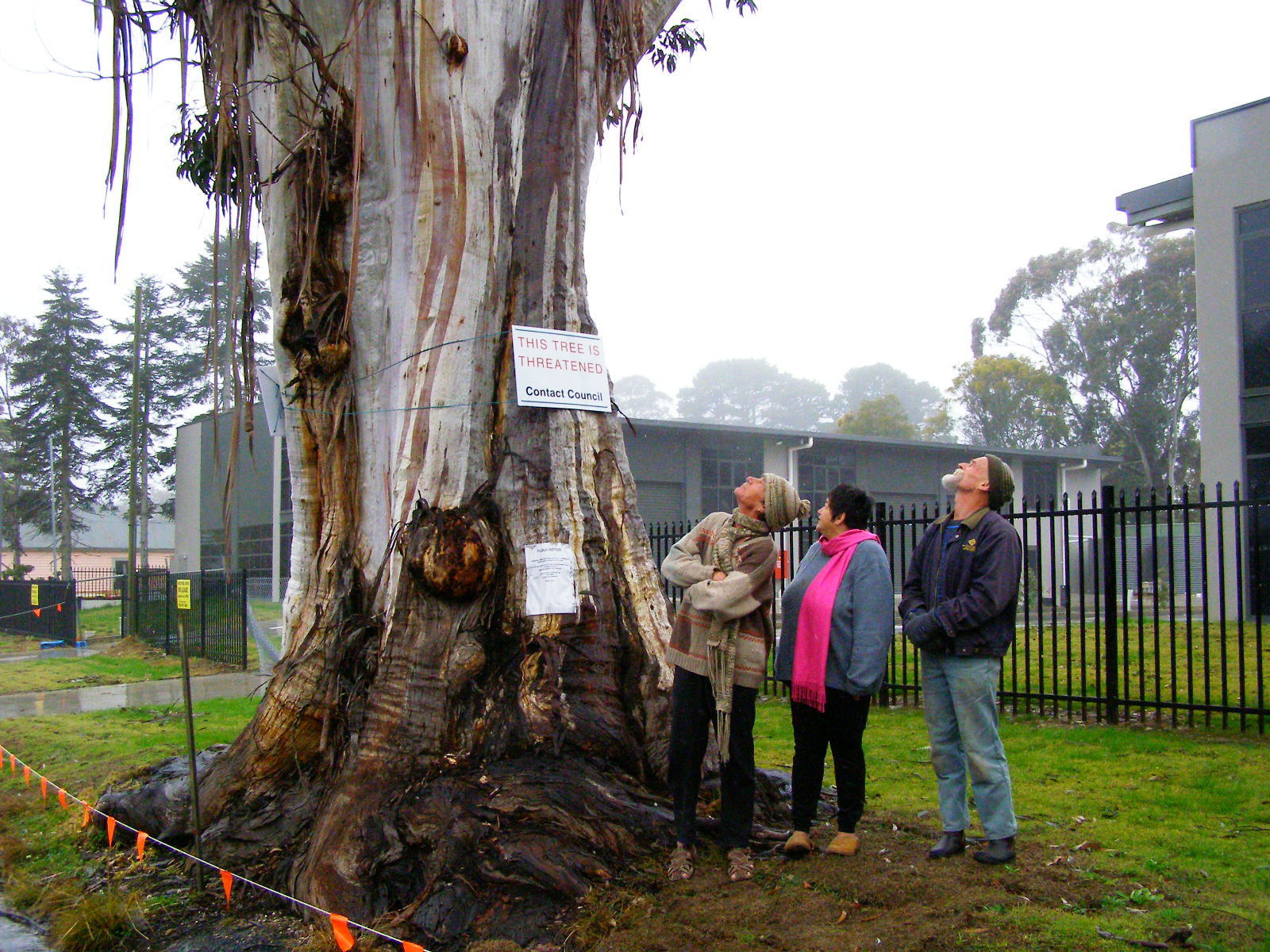 Katoomba residents Maureen and Peter Toy with Glenn Humphreys (right) marvel at Katoomba’s largest native tree
[Photo © Friends of Atlas, 20140907, click image to enlarge]
Katoomba residents Maureen and Peter Toy with Glenn Humphreys (right) marvel at Katoomba’s largest native tree
[Photo © Friends of Atlas, 20140907, click image to enlarge]
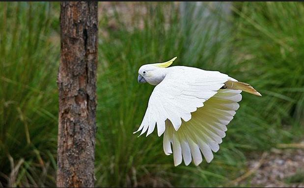 Sulphur-crested Cockatoo (Cacatua galerita)
These character parrots may be of ‘Least Concern’ to IUCN, but to the clan of cockies habitating Atlas, this is their home.
[Source: Zoos Victoria, ^http://www.zoo.org.au/healesville/animals/sulphur-crested-cockatoo]
Sulphur-crested Cockatoo (Cacatua galerita)
These character parrots may be of ‘Least Concern’ to IUCN, but to the clan of cockies habitating Atlas, this is their home.
[Source: Zoos Victoria, ^http://www.zoo.org.au/healesville/animals/sulphur-crested-cockatoo]
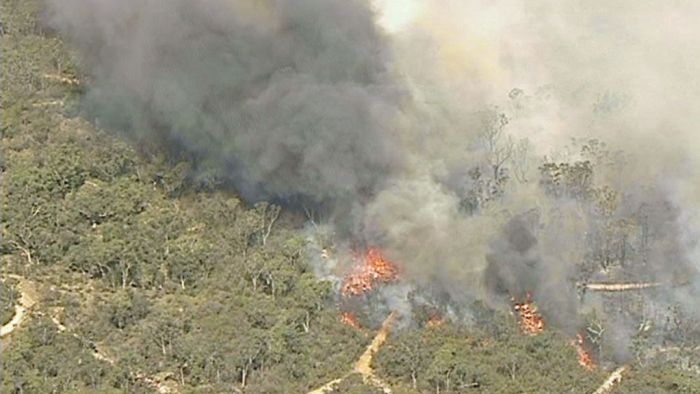
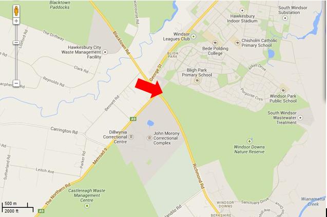
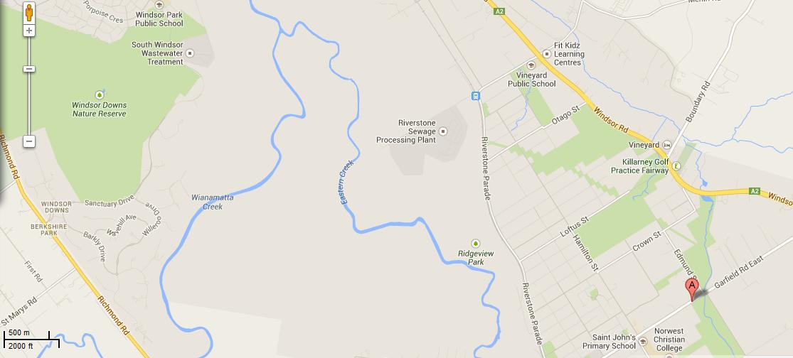
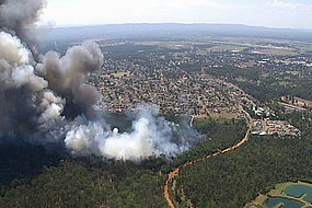
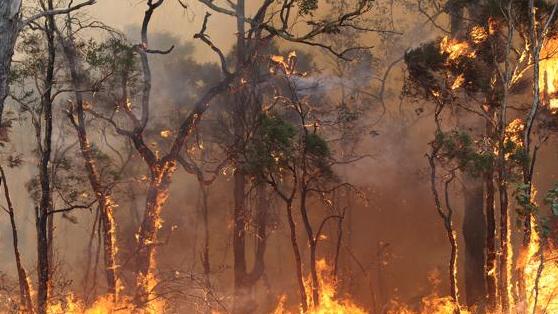

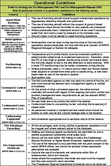
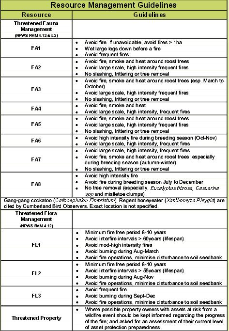

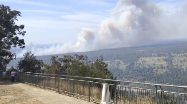


 The classic image of the ‘Camp Fire’


")


")


")
")


")

")


")


")


")


")

")
")
")
")

")


")
")


