Archive for the ‘Quolls’ Category
Wednesday, July 26th, 2017
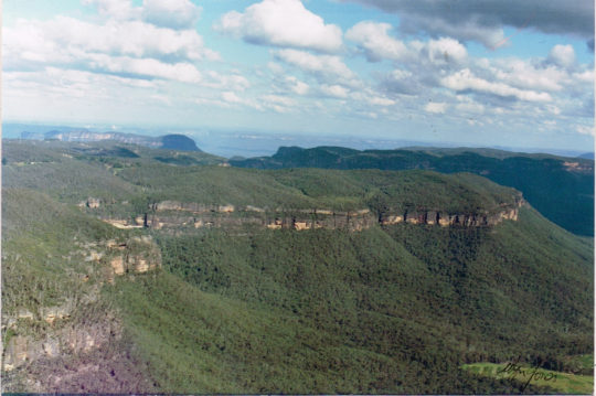 Elphinstone Plateau from the north Elphinstone Plateau from the north
© c.1991 Wyn Jones (biologist, NPWS)
Elphinstone Plateau is magnificently wild, forming an outstanding undeveloped peninsula-plateau jutting out into the Megalong. It has long been a favourite wilderness destination for bushwalkers and rock climbers alike.
This predominantly natural and undisturbed plateau is mistakenly also referred to as ‘radiata plateau‘ due to a small invasive private pine plantation from the 1970s covering less that 5% of the plateau along an access track . The plantation failed and the owner went broke.
Yet little known Elphinstone Plateau remains special home to rare and threatened regionally native species, culturally significant to local Aboriginal peoples and a magnet for the local outdoor community.
Sitting on the southern escarpment, Elphinstone Plateau, just west of Katoomba, towers high above rolling valleys has outstanding topography. It remains the last remaining undeveloped peninsula-plateau in the upper Blue Mountains. The Plateau has significant biodiversity, including vegetation communities such Blue Mountain Swamps, Eucalyptus Oreades Open Forest and Blue Mountains Heath. It is also home to many endangered species including the Flame Robin, Glossy Black Cockatoo, Gang-Gang Cockatoo and the Varied Sittella as well as the Tiger Quoll, frequently sighted by locals. Threatened plants include one of only ten places on the planet where the Dwarf (Blue) Mountain Pine (Pherosphaera fitzgeraldii) is endemic on the planet to the immediate upper Central Blue Mountains with its distribution fragmented to a few south-facing hanging swamp cliff faces on the Blue Mountains western escarpment at Elphinstone above Nellies Glen and nearby around Wentworth Falls above the Jamison Valley.
The IUCN reports that this taxon is endangered. It faces a very high risk of extinction in the wild in the near future due to a small population size and severe population fragmentation, with no sub-population estimated to contain more than 250 mature individuals.
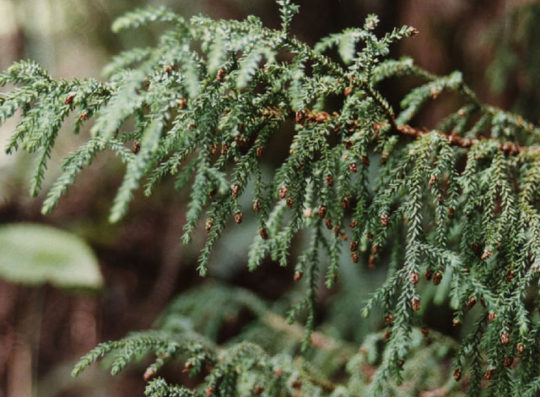 The Dwarf Mountain Pine endemic on the planet to wet rocks within the spray of waterfalls of Elphinstone and Wentworth Falls The Dwarf Mountain Pine endemic on the planet to wet rocks within the spray of waterfalls of Elphinstone and Wentworth Falls
(Harden 1990, Hill 1998)
Steven, one of our local conservationists says that this wild plateau has significant biodiversity – Blue Mountain Swamps, rare Eucalyptus oreades Open Forest and many endangered species including the Flame Robin, Glossy Black Cockatoo, Gang-Gang Cockatoo, and the almost unknown Tiger Quoll.
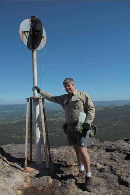 One of our local conservationists at Megalong Head on Elphinstone Plateau One of our local conservationists at Megalong Head on Elphinstone Plateau
Steven says that the plateau and its immediate surrounds provide are the only locality on the planet to naturally support the critically endangered Dwarf Mountain Pine and the little-known yellow flowering shrub Elphinstone Boronia (Leionema lachnaeoides). Both are threatened with extinction and their survival depends on the area remaining undisturbed.
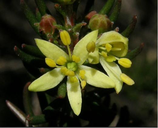 Threatened species Elphinstone Boronia (Leionema lachnaeoides) Threatened species Elphinstone Boronia (Leionema lachnaeoides)
Endemic to Elphinstone Plateau (that means it grows natively nowhere else on the planet)
© Waratah Software
Survival depends on the area remaining undisturbed.
Steven says local resident Glenn Humphreys has been involved with trying to protect and save Mount Elphinstone from housing development on and off for more than 25 years, successfully halting all sorts of elaborate development proposals.
But now this wild and unique haven is at risk. An integrated part of the Blue Mountains western escarpment has come under threat of land use development again – Mount Elphinstone (also mistakenly called Radiata Plateau) situated a few kilometres west of Katoomba. Apart from a small area of Crown Land the majority of the Plateau is privately owned by a group that have repeatedly lodged development applications since the 1990s.
Elphinstone Namesake
Mount Elphinstone, being the highest rise on the plateau is believed named after Major General Sir Howard Craufurd Elphinstone, VC, KCB, CMG (1829 – 1890) who was a British Army officer and a recipient of the Victoria Cross.
Born in Livonia (now Estonia), Elphinstone joined the British Corps of Royal Engineers as a gentleman cadet at the Royal Military Academy, Woolwich and was commissioned as a second lieutenant in December 1847. With the outbreak of the Crimean War, Elphinstone was posted to the Crimea.
On 18 June 1855, he was 25 years old, and a lieutenant in the Royal Engineers, during the Siege of Sebastopol when the following deed took place for which he was awarded the Victoria Cross.VC.
His citation read:
“For fearless conduct, in having, on the night after the unsuccessful attack on the Redan, volunteered to command a party of volunteers, who proceeded to search for and bring back the scaling ladders left behind after the repulse; and while successfully performing this task, of rescuing trophies from the Russians, Captain Elphinstone conducted a persevering search, close to the enemy, for wounded men, twenty of whom he rescued and brought back to the Trenches.”
With the end of the war he was decorated by both Napoleon III, Emperor of France being appointed as a Knight of the Legion of Honour.
Private Development Threats to the Plateau
A proposed private development threatens its future. Currently, two of three development applications recently lodged have been refused, leaving one approved for two dwellings. They pose an inappropriate development wedge to future residential exploitation of this still wild plateau.
Now is the time to prevent any building and move the Plateau in public ownership for protection. This could be the public’s last chance to secure the future of this stunning area and have Elphinstone Plateau become part of the National Park estate.
Blue Mountains residents, the local outdoor community, and the Blue Mountains Conservation Society are all firmly committed to seeking protection for the Plateau. We were delighted with all the community support our campaign received at Winter Magic – with lots of cheers from the crowd during the parade and most importantly all the letters sent off to the Minister for the Environment.
We are seeking to have Elphinstone Plateau purchased by the New South Wales or Australian Commonwealth governments and be incorporated into the Blue Mountains World Heritage Area.
But the battle is not yet won. The local Blue Mountains Conservation Society is championing an environmental campaign to oppose the land use development and to have the plateau incorporated into the adjacent Blue Mountains World Heritage Area.
The Society is inviting locals and those passionate about protecting this special place, to join in a rally on Sunday 30th July at 1.30pm at Cahill’s Lookout, Cliff Drive, Katoomba.
Further Reading:
.
[1] Leave Radiata Plateau Wild Campaign, ^ http://www.bluemountains.org.au/leaveradiataplateauwild/
.
[2] Elphinstone (Radiata) Plateau – Bushwalk: Bottleneck Pass and The Devils Hole (29 June 2016) by Dave Noble (NPWS), ^ http://www.david-noble.net/blog/?p=11300
.
[3] Dwarf Mountain Pine (Pherosphaera fitzgeraldi), The Gymnosperm Database, ^ http://www.conifers.org/po/Pherosphaera_fitzgeraldi.php
.
[4] Major General Sir Howard Craufurd Elphinstone, ^ https://en.wikipedia.org/wiki/Howard_Craufurd_Elphinstone
.
Sunday, September 2nd, 2012
[The following article was written by Tigerquoll and initially published under the title ‘Anthology of State Serial Rape of Bermagui’s Spotted Gum Forest Habitat‘, on ^CanDoBetter.net 20100216]
 Click this image to play music
then click back to this article as it plays Click this image to play music
then click back to this article as it plays
.
 Nothing less than the Australian Government can be trusted to protect vital Koala Habitat.
Lesser smaller-minded state governments only see Koala Habitat as a logging and tourism resource.
Small minded politicians like Kristina Keneally can never be trusted with national treasures
Nothing less than the Australian Government can be trusted to protect vital Koala Habitat.
Lesser smaller-minded state governments only see Koala Habitat as a logging and tourism resource.
Small minded politicians like Kristina Keneally can never be trusted with national treasures
.
 Bermagui’s Spotted Gums
..the local Narooma Community in their defence against ‘Forest NSW’ (the Forest-Fiddling loggers)
Bermagui’s Spotted Gums
..the local Narooma Community in their defence against ‘Forest NSW’ (the Forest-Fiddling loggers)
.
 Forest-Fiddling Logger driving his Spotted Gum spoils truck
.
") But Eucalyptus maculata is a tree, not a floor But Eucalyptus maculata is a tree, not a floor
.
In terms of Australia’s iconic ‘Spotted Gum’, the word “spotted” refers to the soft mottled colour caused by weathering of the outer tree as it sheds elliptical strips of bark.
 Spotted Gum bark Spotted Gum bark
.
This colour varies from pale greybrowns and soft creams to a rich chocolate brown. A very tough timber, its frequent wavy grain can produce an attractive and highly valued fiddleback effect. [Source: Boral website, ^http://www.boral.com.au/timberflooring/timber_species_-_spotted_gum.asp]
.
 Build something great, but don’t destroy something great in the process
– like Koala Spotted Gum Forests!
Invest in Boral and you invest in Koala extinction
Build something great, but don’t destroy something great in the process
– like Koala Spotted Gum Forests!
Invest in Boral and you invest in Koala extinction
.
About 380km south of Sydney lies what NSW Tourism labels the beautiful ‘Sapphire Coast’ with the popular seaside town of Bermagui.
Less than 3km north of Bermagui heading north along Bermagui-Cobargo Road and up the Bermagui River estuary is the Bermagui State Forest – a label by the NSW Department of Primary Industry (DPI) given to magnificent Spotted Gum forest.
 . .
This forest is vital habitat for threatened native fauna – the Yellow Bellied Gliders, Grey-Headed Flying Foxes, Tiger Quolls, Sooty Owls, Sea Eagles, Possums and Australia’s iconic Koala.
.
 Koala in Bermagui’s Spotted Gum forest – a displaced landlord
.
Australia’s iconic ‘Spotted Gums’
.
 A mature iconic Spotted Gum Tree
About 400 years old, about 30 metres high
A mature iconic Spotted Gum Tree
About 400 years old, about 30 metres high
[Source: ‘A gum tree that saw Captain Cook and before’, ABC Radion interview of John Knight by Ian Campbell, 20100119,
Listen to Interview: ^http://blogs.abc.net.au/nsw/2010/01/a-gum-tree-that-saw-captain-cook-and-before.html]
.
Australia’s magnificent and unique Spotted Gums are naturally distributed in open forests along the hilly coastal corridor from south-east Queensland down through New South Wales and with a few isolated pockets in East Gippsland, Victoria. They belong to the botanical family ‘Myrtaceae’ and grow straight and tall up to 40 metres. Their height attracts roosting by Sea Eagles.
 Note the planet’s sole natural distribution of Spotted Gum Forests
They have become the target of corporate development simply because Spotted Gums prefer a mild temperate climate near the coast
..like Australia’s millions of breeding humans, and profiteering corporate developers
Note the planet’s sole natural distribution of Spotted Gum Forests
They have become the target of corporate development simply because Spotted Gums prefer a mild temperate climate near the coast
..like Australia’s millions of breeding humans, and profiteering corporate developers
.
Spotted gums flower once every two years and produce a rich pollen that attracts native birds such as Lorikeets and Yellow Tailed Cockatoos as wells as possums and flying foxes including the IUCN vulnerable listed Grey-Headed Flying Fox. [Source: Australian Native Plants Society, Corymbia maculata, ^http://asgap.org.au/c-mac.html]
") Grey-Headed Flying Fox (Pteropus poliocephalus)
The grey-headed flying-fox is listed as vulnerable to extinction under NSW and Australian legislation because of declining numbers and key threats such as habitat loss and urban conflict. Records indicate that grey-headed flying-foxes may once have numbered in the millions, but are now reduced to as few as 400,000. In the decade before listing, their population was estimated to have declined by 30%.
(Photo by Ákos Lumnitzer, ^http://amatteroflight.com/) Grey-Headed Flying Fox (Pteropus poliocephalus)
The grey-headed flying-fox is listed as vulnerable to extinction under NSW and Australian legislation because of declining numbers and key threats such as habitat loss and urban conflict. Records indicate that grey-headed flying-foxes may once have numbered in the millions, but are now reduced to as few as 400,000. In the decade before listing, their population was estimated to have declined by 30%.
(Photo by Ákos Lumnitzer, ^http://amatteroflight.com/)
.
Unlike the declaration of a ‘National Park’ which affords federal environmental protection to forest habitat, the State label of a ‘State Forest’ is a misnomer. A ‘State Forest’ is deemed a timber and woodchip resource for logging. The same public relations label is used across New South Wales, ACT, Victoria, Western Australia, Tasmania and Queensland. A State Forest is not treated as a forest for its natural habitat values, but rather as a logging coup on death row, that can be chainsawed at will anytime. Perhaps ‘Death Row Forest’ is a more apt label than speaking the State euphemism of ‘State Forests’.
And its public relations label logging as ‘harvesting’, a euphemism to belie the destructive reality.
 Bermagui State Forest after the loggers Bermagui State Forest after the loggers
.
The NSW Logging Offensive of 1988
.
On the back of a century of clear felling Bermagui State Forest was logged in the late 1980s. Then according to data from the ‘Bureau of Resource Science‘ (aka science graduates on the payroll of loggers), 148ha were “thinned” in 1996, and another 133ha that same year, then 94ha in 1999.
Typically 70% of the spotted gums goes to Boral’s mills in Narooma, Nowra and Batemans Bay as sawlogs to be processed into mainly flooring. The remainder end up as woodchips at Nippon Paper’s woodchip mill at Twofold Bay for export to Japan.
So Australia’s precious endangered habitat is being destroyed for house flooring and office paper. .
.
The NSW Logging Offensive of 2008
.
In October 2008, NSW Forests logged what it labeled “two compartments” in Bermagui State Forest north of Bermagui. It justified this under the infamous Eden Regional Forest Agreement (RFA). [>Read Agreement] [Source: ^http://www.daff.gov.au/__data/assets/pdf_file/0009/51021/nsw_rfa_eden.pdf]
This RFA is one of three established in 1999, in which the NSW Government relegated 15.1 million hectares of native forests across New South Wales for logging anytime. The usual public relations spin preceded the logging. Southern Region manager of Forests NSW, Ian Barnes.
It was at this time that Labor’s Minister for Primary Industries (Forests NSW) Ian MacDonald and Labor’s Minister for Police Tony Kelly started to use Dick Cheney tactics to push their weight around with protesters. The following questions to the NSW Legislative Council by NSW Greens Senator Lee Rhiannon on 28th October 2008, highlight the escalated use of law enforcement into a heavy handed riot squad:
.
Lee Rhiannon MLC:
“I direct my question to the Minister for Police. Did officers stationed at Batemans Bay police station in collaboration with Forests New South Wales hold a meeting at the Bermagui Country Club in September to warn locals associated with calling for forest protection not to protest when logging commenced in the Bermagui State Forest? Does the holding of this meeting reflect that Batemans Bay police officers have adopted a zero tolerance policing approach to forest protesters? Considering that since logging started in Bermagui State Forest on 27 October with a group of about 40 protesters gathered in the vicinity, about 15 police cars, more than 20 police, including members of the Public Order and Riot Squad, a mobile police command bus and two police rescue vans have been in attendance, will this level of policing continue for the coming six weeks of logging in this area? What is the anticipated cost of this operation?
.
Tony Kelly MLC (response):
“The Far South Coast Local Area Command of the New South Wales Police Force has been advised that New South Wales Forests is to commence logging compartments of Bermagui State Forest later this month. As in the past, protests are expected. As always, the New South Wales Police Force is committed to maintaining public order. For this reason, local police and various commands, including the Public Order and Riot Squad, Highway Patrol and Rescue Squad will join together to conduct an operation.
This operation will focus on ensuring the protection of persons engaged in lawful activities. Local police have made it clear that anyone engaging in unlawful or dangerous activity in or near the logging operation will have action taken against them. When offences continue and are considered dangerous, police will arrest and charge people as necessary. Police respect people’s rights to protest during these times; in no way are they looking to prevent lawful and peaceful protests. Police have asked anyone who intends to protest to contact them so that they can attempt to facilitate lawful activity, minimise disruption and focus on protecting the safety of everyone involved.”
.
[SOURCE: ‘Bermagui State Forest Logging Protests‘, Question raised NSW Legislative Council by The Greens Senator Lee Rhiannon, Parliament of New South Wales, Hansard, 20081028, ^http://www.parliament.nsw.gov.au/prod/parlment/hanstrans.nsf/V3ByKey/LC, 20081028, >Read Hansard Extract – go to page 10631, PDF, 344kb ]
.
The NSW Logging Offensive of Feb 2009
.
On Monday 2nd February 2009, logging operations resumed in the Bermagui State Forest after the summer holiday break period and continued for about two months.
Bruce Mathie and Sons is one of the prominent loggers in the area, but most timber finds its way either as saw logs to Boral for Spotted Gum flooring or else to Nippon Papers woodchip mill at Twofold Bay, Eden for export to Japan.
The forest eco-rapers ‘Forests NSW’ – bulldozed, chainsawed, logged, then left with their booty.
.
 Kevin Mathie – 4th generation logger Kevin Mathie – 4th generation logger
.
 Logging contractor, Gil Mathie, in the middle of the picture at front (pink jumper)
More notably, this editor is saddened by bearing witness to a senior member
of the Bermagui community being arrested for conserving Spotted Gums and Koalas.
We love, we defend, we act for love.
Salute the man being arrested.
[Source: Local environmentalist, John Perkins, Gulaga Protest near Tilba on the NSW South Coast, 20070514]
Logging contractor, Gil Mathie, in the middle of the picture at front (pink jumper)
More notably, this editor is saddened by bearing witness to a senior member
of the Bermagui community being arrested for conserving Spotted Gums and Koalas.
We love, we defend, we act for love.
Salute the man being arrested.
[Source: Local environmentalist, John Perkins, Gulaga Protest near Tilba on the NSW South Coast, 20070514]
.
Labor’s Ian MacDonald’s Forestry Regulation of 2009
.
But rather that do the right thing by the Environment and by the Community and obey the law of the land, those in power The Labor Government’s (Forests NSW) forced changes to the law of the land to bloody well suit themselves. Arguably reminiscent of England’s King Henry VIII changing laws to accommodate his adultery, or Joh Bjelke-Petersen’s gerrymandering that secured his electoral hold on power.
In order to keep the cameras and local conservationist away from the loggers destructive practices, Forests NSW got the Minister to legislate an exclusion area around its logging with the public relations labeling of “mainly for safety reasons”.
On 1 September 2009, the NSW Forestry Regulation 2009 came into force making it illegal for anyone to trespass into areas marked by NSW Forests for logging. This has given Forests NSW absolute logging power with the police as its enforcement lackies.
Forests NSW Minister for Primary Industries, Ian MacDonald, tabled the Bill and it became law preventing democratic protests by people trying to save important habitat from destruction. It has given loggers free reign to log State Forests with impunity.
Under Part 3, Division 1, Clause 11 of this Regulation, a logger has legal authority to request anyone to leave a forestry area and this includes if that person “causes inconvenience.”
Under Clause 12, a logger can forcible remove anyone from a forestry area “who is causing annoyance or inconvenience.”
Surely such removal by a logger can be construed an assault under the Crimes Act? It is draconian. It is certainly an assault on Australians’ democratic right to protest. What was Ian MacDonald thinking?
.
Labor’s Ministers in charge three years hence…
.
 Labor’s Police Minister Tony Kelly MLC
NSW Minister for Emergency Services, Lands, Police and Primary Industries.
Labor’s Police Minister Tony Kelly MLC
NSW Minister for Emergency Services, Lands, Police and Primary Industries.
.
‘Tony Kelly was targeted by protesters as he arrived to give evidence at the ICAC in June. Today the commission has found the former minister engaged in corrupt conduct.’
[Source: Protesters target Kelly outside ICAC’, by Dean Lewins, AAP, 20111212, ^http://www.abc.net.au/news/2011-12-12/protesters-target-kelly-outside-icac/3725744]
.
‘DISGRACED former state Labor ministers Tony Kelly and Ian Macdonald are demanding taxpayers foot their legal bills and the state government could be forced to hand over up to $250,000. Despite being found by corruption watchdog ICAC to have forged official documents while a minister, Mr Kelly has formally asked the O’Farrell government to cover the cost of his elite legal team.’
[Source: ‘Disgraced former Labor ministers Tony Kelly and Ian Macdonald demand taxpayers foot their bills’, by Barclay Crawford, Daily Telegraph, 20120101, ^http://www.dailytelegraph.com.au/news/disgraced-former-labor-ministers-tony-kelly-and-ian-macdonald-demand-taxpayers-foot-their-bills/story-e6freuy9-1226234077573].
.
 Labor’s Logging Minister Ian MacDonald MLC
Forests NSW/ Minister for Primary Industries in 2009 Labor’s Logging Minister Ian MacDonald MLC
Forests NSW/ Minister for Primary Industries in 2009
.
‘The disgraced former NSW resources minister Ian Macdonald is to face a new corruption inquiry into the granting of coal exploration licences. The Independent Commission Against Corruption said in a statement yesterday that Mr Macdonald is being investigated for allegedly using his ministerial position ”to advantage the private interests of others”.
[Source: ‘ICAC to examine mining licences‘, by Kate McClymont, Senior Reporter, Sydney Morning Herald, 20120524, ^http://www.smh.com.au/nsw/icac-to-examine-mining-licences-20120523-1z5ov.html‘]
.
‘The senior state minister Ian Macdonald signed taxpayers up to the V8 Supercars race without a system to manage potential conflicts of interest, without advice from the government’s major events body and without a proper business case, the NSW Auditor-General finds.’
[Source: ‘Mate’s race: $45m deal snares MP‘, by Anne Davies, Linton Besser and Nick O’Malley, 20100529, ^http://www.smh.com.au/nsw/mates-race-45m-deal-snares-mp-20100528-wldb.html]
.
The NSW Logging Offensive of Sep 2009
.
In September 2009, Forests NSW commenced logging again in Bermagui State Forest, like pack rapists marauding through a maternity ward.
Sure enough, on Monday, 14th September 2009, Police arrested two of four forest campaigners who had allegedly entered Bermagui State Forest in what Forests NSW had labeled logging compartments 2001 and 2002. Apparenpe known to support koalas is unacceptable, particularly when the NSW government cannot prove their claims that koalas can be found anywhere in the south east,” said Robert Bertram, local Friends of Five Forests member.
“This is yet another example of Forests NSW lack of care for community and the environment,” said Lisa Stone, spokesperson for South East Forest Rescue.
“They are logging old-growth in Dampier, threatened species habitat in South Brooman, endangered species habitat in Nadgee and now this.”
“The loss of biodiversity coupled with logging and burning means the condition of many forests is as bad as the endangered ecological communities on private land, unable to support most threatened and endangered species and unable to recover.”
“We urge the newly appointed Minister for the Environment, Mr John Robertson, to step in on behalf of the native forests and their dependents and stop these archaic practices.”
“The current government policy of destroying habitat to satisfy ‘wood supply agreements’ is robbing from the future generations their chance of survival. The amount of breaches was astounding and shows that Forests NSW cannot be trusted to log these important areas of Koala habitat.”
“We have inspected many other logging operations in the past year and have found the same breaches everywhere we have looked. This is pe known to support koalas is unacceptable, particularly when the NSW government cannot prove their claims that koalas can be found anywhere in the south east,” said Robert Bertram, local Friends of Five Forests member.
“This is yet another example of Forests NSW lack of care for community and the environment,” said Lisa Stone, spokesperson for South East Forest Rescue.
 A community morally right to defend habitat and prepared to defend that right A community morally right to defend habitat and prepared to defend that right
.
“They are logging old-growth in Dampier, threatened species habitat in South Brooman, endangered species habitat in Nadgee and now this.”
“The loss of biodiversity coupled with logging and burning means the condition of many forests is as bad as the endangered ecological communities on private land, unable to support most threatened and endangered species and unable to recover.”
“We urge the newly appointed Minister for the Environment, Mr John Robertson, to step in on behalf of the native forests and their dependents and stop these archaic practices.”
“The current government policy of destroying habitat to satisfy ‘wood supply agreements’ is robbing from the future generations their chance of survival. The amount of breaches was astounding and shows that Forests NSW cannot be trusted to log these important areas of Koala habitat.”
“We have inspected many other logging operations in the past year and have found the same breaches everywhere we have looked. This is not a once off mistake but a systemic disgust for any environmental protection measures.”
Conservationists state the native forest logging industry is unsustainable and only propped up by political will, public subsidies and union backing.
Spokesperson for the South East Region Conservation Alliance, Pru Acton, says:
“The significant social and economic costs of reduced biodiversity can only increase while our natural systems are poorly managed.”
“Credible experts agree that the cost of logging this habitat is not only the last few koalas, but also potable water supplies, oysters, the inspiration for the local artists community, and another chunk of the Wilderness Coast’s tourism potential.”
“It seems the NSW Government has now decided its contractual obligations to supply sawlogs locally and woodchips to Asia is more important then protecting this much loved native animal.”
.
South East Region Conservation Alliance
.
Conservationists state the native forest logging industry is unsustainable and only propped up by political will, public subsidies and union backing.
Spokesperson for the South East Region Conservation Alliance, Pru Acton, says: “The significant social and economic costs of reduced biodiversity can only increase while our natural systems are poorly managed.”
“Credible experts agree that the cost of logging this habitat is not only the last few koalas, but also potable water supplies, oysters, the inspiration for the local artists community, and another chunk of the Wilderness Coast’s tourism potential.”
“It seems the NSW Government has now decided its contractual obligations to supply sawlogs locally and woodchips to Asia is more important then protecting this much loved native animal.”
.
[Source: ‘Logging resumes at Bermagui’, by Stan Gorton Narooma News, 20090204 – note the Narooma News has removed this news item online. However, the Narooma News has chosen not to remove its following story (Source: ^http://www.naroomanewsonline.com.au/story/191381/albino-possum-causes-log-truck-roll-over-at-narooma/ if it be not similarly removed].
 Speeding logging trucker blames possum
..Narooma News editor’s reputation shot Speeding logging trucker blames possum
..Narooma News editor’s reputation shot
.
Narooma News spins the following story to appease local logger readership:
.
“In a bizarre set of circumstances, a rare but dead albino possum is believed to have caused a log truck roll-over on the Princes Highway just south of Narooma.
The accident occurred just after 1pm when witnesses said a local from Wallaga Lake stopped to look at the road-kill possum that had been lying on the roadside at the entrance to the Island View Beach Resort.
A series of cars backed up behind the stopped vehicle in the southbound lane. Another Narooma local who was last in the line of stopped cars looked in his rear-vision mirror only to see the huge red-coloured truck coming up fast from behind.
“I think I am going to buy a lottery ticket,” said the local, who at one point thought the truck was going to smash into him and end his life.
The truck driver then allegedly swerved onto the wrong side of the road, narrowly missing the line of cars and while he was fortunate not to face any oncoming northbound traffic, he did lose control on the straight stretch of highway.
The truck reportedly clipped a boat trailer, flipped onto its side, sliding down the highway with the prime mover coming to rest in bushland just off the verge north of the Nangudga Bridge.
An ACT couple who among those first on the scene were able to help the truck driver out of the cab but they said he was badly shaken up and was not aware of where he was.
The Pambula man was the only person injured in the accident and was taken to Moruya Hospital for treatment.
The highway was closed down to one lane with firefighters, police and RMS personnel cleaned up and investigated the scene.
Residents from the nearby Island View caravan park were alerted to the accident by a loud bang and they lined the highway watching the accident.
The accident occurred at the start of the June long weekend where NSW police were out in force urging drivers to be careful on the busy roads.
Albino or golden brush-tailed possums are very rare but there is a known population living in the Narooma area.’
.
~ by the Narooma News editor…and watch out for drop bears too!
.
Meanwhile NSW Forests remains culturally contemptuous to NSW forests
.
Forests NSW recruit their students with Communications degrees to lie for it on its website:
“State forests in NSW are managed sustainably to provide a supply of timber today and into the future, to protect the environmental values of the forest and provide community amenities.”
Forests NSW website claims that “Ecologically sustainable forest management (ESFM) is our guiding philosophy. ESFM is about managing forests to maintain ecological principles and biodiversity while optimising the benefits to the community from all uses of the forest…”
 Narooma Community in defence of Koala Habitat
– clearly not convinced about Forests NSW spiel about “optimising the benefits to the community” Narooma Community in defence of Koala Habitat
– clearly not convinced about Forests NSW spiel about “optimising the benefits to the community”
.
Revolving Door politics of NSW Labor
.
In the revolving door politics of NSW Labor, Premier #3 Nathan Rees on 16th November 2009 sacked Ian MacDonald from his DPI Ministry.
Rees was himself sacked as premier on 3 December, then a week later, Labor Premier #4 Kristina Keneally (Labor show pony) reappointed Ian MacDonald ‘Minister for State & Regional Development and Minister for Mineral & Forest Resources‘ in December 2009.
The labelling of Minister for ‘Forest Resources’ left NSW State Forests in no doubt about the death row status. Throughout NSW Labor’s factional power shuffle Macca’s chair never got cold.
The then Minister for Primary Industries , Tony Kelly, overseeing Forests NSW, claimed on 18 November 2009: “The NSW Government has a solid track-record for maintaining prosperous and sustainable primary industries, I will be working hard with industry to ensure this tradition continues.”
.
[Source: Source: NSW Department of Primary Industries, ^http://www.dpi.nsw.gov.au/__data/assets/pdf_file/0019/308251/Minister-Kelly-Visits-Industry-and-Investment-NSW-Headquarters.pdf, since deleted by the NSW Government – the file, not the department unfortunately]
.
Tigerquoll’s Position
.
All State Forests should be added to Australia’a National Park Estate. State Governments and their narrow mindset culture cannot be trusted with ecology. Boral and Nippon Paper can transition their logging operations into plantation-only FSC resources.
The Twofold Bay Woodchip Mill was set up near Eden in 1969 by Daishowa Paper Manufacturing Company has exported and profitted from over 35 million tonnes of Australian native forest woodchips, mostly to Japan, where its parent company is based.
In contributing to the annihilation of thousands of hectares of Australia’s native forest habitat the Daishowa Twofold Bay Woodchip Mill is Australia’s Habitat Auschwitz. It must be unceremoniously closed down immediately.
 Daishowa – Japan’s BIG Corporate Eco-Rapist and BIG Koala Exterminator Daishowa – Japan’s BIG Corporate Eco-Rapist and BIG Koala Exterminator
.
 Boral Spotted Gum – corporate shareholder perspective
. Boral Spotted Gum – corporate shareholder perspective
.
") Spotted Gums too magnificent to kill
[Source: Save Our Water Ways Now, photo by Robert Whyte,
^http://www.saveourwaterwaysnow.com.au/01_cms/details_pop.asp?ID=135] Spotted Gums too magnificent to kill
[Source: Save Our Water Ways Now, photo by Robert Whyte,
^http://www.saveourwaterwaysnow.com.au/01_cms/details_pop.asp?ID=135]
.
Further Reading:
.
[1] South East Region Conservation Alliance, ^http://www.serca.org.au/
.
[2] ‘South East Forests must be protected’, by Greens MP David Shoebridge, 20110629, ^http://davidshoebridge.org.au/2011/06/29/south-east-forests-must-be-protected/
.
‘Greens MP David Shoebridge today met with local campaigners and timber workers in the Bermagui State Forest to get a first-hand view of the impact of continued logging in the South East Forests.

“There is a real concern that this logging is further fracturing the remaining stands of koala habitat in the South East,” Mr Shoebridge said.
“The logging is being undertaken in a nature corridor that links Wallaga Lake National Park and Bermagui Nature reserve. This corridor should be protected.
“With the logging at Bermagui coming within a few hundred meters of town the prospects of more intensive and drier regrowth producing higher levels of fire hazard are real.

“Forests NSW has said that the beautiful “cathedral” entrance to Bermagui will be protected. However on closer inquiry only a small part of the western side and a 50m ‘visual protection zone’ to the east is currently protected.
“In discussions with Forests NSW today they have committed to reviewing the decision on the cathedral to consider protecting all of it from logging. This would be a welcome, if modest, concession.
“The South East Forests are a priceless natural asset and this new State government has a real chance to break with the past and save them from continued logging for wood chips.
“Local campaigners are committed to saving these beautiful forests and this will remain a key focus in the coming years,” Mr Shoebridge said.
.
[Ed: That was over a year ago – our love and commitment for the old forest – we remember ]
.
Tags: Bermagui Community, Bermagui State Forest, Boral, Build something great, Eucalyptus maculata, Forest-Fiddling Loggers, Forests NSW, Grey-Headed Flying Foxes, Ian Macdonald, koala habitat, Kristina Keneally, Logging, Narooma Community, Sapphire Coast, Save the Koala, South East Corner, South East Forest Rescue, Spotted Gum
Posted in Koalas, Possums and Gliders, Quolls, South East Corner (AU), Threats from Deforestation | No Comments »
Add this post to Del.icio.us - Digg
Friday, August 10th, 2012
 Dead fox found near Braeside Track, Blackheath, Blue Mountains in 2006
There was no sign of it being shot. Was it baited? Dead fox found near Braeside Track, Blackheath, Blue Mountains in 2006
There was no sign of it being shot. Was it baited?
(Photo by Editor, 20060722, free in public domain, click image to enlarge)
.
In June 2012, Gerry from Hazelbrook in the Blue Mountains west of Sydney wrote in the local Blue Mountains Gazette newspaper:
“Our place backs on to bushland. The other morning I was looking out the kitchen window and I saw two foxes just beyond our back fence, ambling along, very relaxed, looking like they owned the place. They were large, and looking extremely well fed.
A few days earlier I had seen a very large feral cat stalking prey in the same area.
Question: whose brief is feral animal control in the Blue Mountains, and what to they actually do about the problem?”
[Source: ‘Who is responsible?’, (letter to the editor), by Gerry Binder, Hazelbrook, Blue Mountains Gazette, 20120627, p.4]
.
Well, no one from the authorities responded to Gerry in the newspaper.
So who is responsible for fox control across the Blue Mountains? One would be inclined to consider the local Blue Mountains Council, or the regional National Parks and Wildlife Service (NPWS) if the fox is in the National Park.
A phone call to Blue Mountains Council today revealed that the Council does not get involved in feral animal control. It has no policy or strategy to deal with the fox problem, or indeed with feral predation in the Blue Mountains local government area (LGA).
This area comprises two east-west human-settled corridors through the central region of the Blue Mountains: (1) along the Great Western Highway (including Hazelbrook) and (2) along the Bells Line of Road. Both corridors are surrounded and upstream of the UNESCO-listed Greater Blue Mountains World Heritage Area.

According to the Blue Mountains Council, feral animal control across the Blue Mountains, outside the World Heritage Area, is handled by the New South Wales Government Department, the Livestock Health and Pest Authority. So to answer Gerry’s question above, if anyone has an issue with foxes outside the World Heritage Area, don’t contact Blue Mountains Council, but instead contact the the Livestock Health and Pest Authority (LHPA).
The LHPA has geographically divided the Blue Mountains region into two serviced districts. From Bullaburra east back toward Sydney, the Cumberland Livestock Health and Pest Authority based at Camden takes an interest (Tel: 02-6331 1377). From Wentworth Falls west to Bathurst, the Bathurst Livestock Health and Pest Authority based at Bathurst takes an interest (Tel: 02-4655 9165).
The Livestock Health and Pest Authority (LHPA) is primarily tasked with safeguarding agriculture from threats – such as feral predation, insect control, livestock disease prevention and health. It has sixty offices across NSW and works with rural producers, government and industry to safeguard agriculture in NSW. The LHPA operates under the Rural Lands Protection Act 1998 (NSW) and is ultimately accountable to the NSW Minister for Primary Industries.
Strangely enough, the LHPA has NOT listed foxes as ‘declared pests’ in NSW. It does list wild rabbits, wild dogs, feral pigs and locusts as declared pests. The reason is one of jurisdiction and legal delegation. The LHPA is primarily charged with safeguarding agriculture, not safeguarding native habitat and fauna. It classes foxes and mice merely as ‘nuisance animals’ throughout New South Wales and states that there is no legal obligation for a landholder in NSW to control foxes or mice. LHPA only provides control advice and assistance to rural property owners. So in relation to fox control, the LHPA is more token and lip service. Blue Mountains Council adopts a complete cop out approach to the fox problem across the Blue Mountains.
From its brochure on foxes, the control methods LHPA adopts for fox control are:
- 1080 poison (sodium monofluoroacetate) – a cruel and indiscriminate poison, that kills slowly (carnivores up to 21 hours) causes pain, suffering, trembling, convulsion and vomiting. It is banned in most countries because it is considered inhumane, but still used across Australia. [Read More: ^http://www.wlpa.org/1080_poison.htm]
- Rubber jawed leg hold traps
- Mesh cage traps, which seem the most humane option.
[Source: Livestock Health and Pest Authority website, ^http://www.lhpa.org.au/pests]
.
This is its public brochure on foxes and note that shooting is not mentioned as an option:
") LHPA Brochure on Foxes
[Source: ^http://www.lhpa.org.au/__data/assets/pdf_file/0016/434014/Final-foxes.pdf] LHPA Brochure on Foxes
[Source: ^http://www.lhpa.org.au/__data/assets/pdf_file/0016/434014/Final-foxes.pdf]
.
A week after Gerry’s letter, on the front page of the Blue Mountains Gazette ran the story of a Burns Road resident in nearby Springwood discovering that his cat Sam had been caught in a wild dog trap. Sam’s legs had been broken by the trap and he was euthanised as a result. The article in the paper stated that the Blue Mountains Council and National Parks and Wildlife Service were jointly undertaking a trapping programme in the Blaxland to Springwood area after receiving complaints about wild dogs. Traps has been set along a fire trail to catch the wild dogs. [Source: ‘Sad end for Sam’, by Damien Madigan, Blue Mountains Gazette, 20120704, p.1]
 Rubber Jaw Leg-Hold Trap Rubber Jaw Leg-Hold Trap
.
That the cat was roaming in the bushland down a fire trail, suggests that it may well have been preying on wildlife as well. What is the difference in wildlife impact between that of a targeted wild dog, and a companion cat that is roaming wild in bushland? That the trap broke the cat’s legs meant that the control method was not humane. It also means that trapping, like poisoning is an indiscriminate form of feral animal control. So herein lies a challenge of feral predator control.
 Native Dingo caught in a rubber jaw leg-hold trap
It confirms that trapping is indiscriminate Native Dingo caught in a rubber jaw leg-hold trap
It confirms that trapping is indiscriminate
.
In May 2011, Paul from Winmalee in the Blue Mountains, with his stated background in wildlife conservation, wrote in his letter in the Blue Mountains Gazette that shooting feral animals as a conservation measure is a largely inefficient way to control foxes. “The National Parks and Wildlife Service has done studies showing that shooting/hunting feral animals has minimal affect (sic) on their numbers”, he said. [Source: ‘Not conservation’ (letter to the editor), by Paul Bailey, Winmalee, Blue Mountains Gazette, 20110511, p.8]
.
 Recreational shooting of feral animals can attract the wrong mentality Recreational shooting of feral animals can attract the wrong mentality
.
Back in July 2011, a local Blue Mountains resident, ‘Don’, asked in his email to The Habitat Advocate “would you like to give some coverage to the lack of ongoing fox control around Katoomba?” Don clarified in his email:
“Quite a good effort was made about 3-4 years ago (2007-08) and for about 18 months afterwards there was no sign of foxes but, as happens all too often with the bureaucratic model of pest animal control, there was no ongoing effort and foxes are now back in serious numbers, as can be detected by direct sightings, tracks and scats.
We have noticed huge losses amongst wood duck especially (the ducklings are very vulnerable to fox predation) and the swamp wallaby population is no-where near what it should be. In fact, observable wallaby numbers are down on what they were ten or fifteen years ago.
The cost of control programmes is obviously an issue. Unfortunately, due to the parasitisation of the environmental movement by animal rights folk, self-sustaining control measures such as the commercial exploitation of foxes for their skins is no longer pursued. If that remains the case, can we realistically expect the politicians ever to find the money for ongoing effective fox control, given the competing environmental considerations, not to mention budgetary issues such as mental health, which is sorely languishing?”
 Feral Foxes are healthy across the Blue Mountains
.
Don’s request happened to be our very first request for onground action and so we shall stay by Don and see that his very legitimate request is pursued.
Our understanding is that across the Blue Mountains region, there are three categories of land ownership/control which would be impacted by fox predation:
- The Greater Blue Mountains World Heritage Area
- Council lands spread across 8 multiple Local Government Areas (LGAs) of:
- Blue Mountains
- Lithgow
- Oberon
- Wollondilly
- Hawkesbury
- Muswellbrook
- Singleton
- Mid-Western Regional (Mudgee)
- Private land including urban, rural, farms and to a small extent, mining leasehold land
") Greater Blue Mountains World Heritage Area
(Source: New South Wales then Department of Environment and Climate Change, 2007)
(Click image to enlarge) Greater Blue Mountains World Heritage Area
(Source: New South Wales then Department of Environment and Climate Change, 2007)
(Click image to enlarge)
.
The custodial responsibility for managing the natural values of the Blue Mountains World Heritage Area is the Australian Government. The area totals roughly 10,000 square kilometres (1.03 million hectares) of sandstone plateaux, escarpments and gorges dominated by temperate eucalypt forest. It comprises eight protected areas:
- Blue Mountains National Park
- Kanangra-Boyd National Park
- Wollemi National Park
- Gardens of Stone National Park
- Yengo National Park
- Nattai National Park
- Thirlmere Lakes National Park
- Jenolan Caves Karst Conservation Reserve
") ‘Blue Mountains World Heritage Area’
Listed by UNESCO in 2000 for its unique and significant natural values
(Photo by the Rural Fire Service) ‘Blue Mountains World Heritage Area’
Listed by UNESCO in 2000 for its unique and significant natural values
(Photo by the Rural Fire Service)
.
Fauna of the Blue Mountains region classified as ‘threatened with extinction’ or ‘rare’ include the Tiger Quoll, the Koala, the Yellow-bellied Glider, the Brush-tailed Rock Wallaby and the Long-nosed Potoroo as well as rare reptiles and endangered amphibians such as the Green and Golden Bell Frog, the Blue Mountain Water Skink and the Broad-headed Snake and endangered birds like the Regent Honeyeater. The largest predator of the region is the Australian Dingo to which its natural prey in the region is the Grey Kangaroo and various subspecies of Wallaby, other macropods, small marsupials and reptiles.
 Tiger Quoll (Dasyurus maculatus)
Also known as the spotted-tail quoll (which we consider a rather naff politically correct name)
An endangered carnivore, native to the Blue Mountains and competing with the Dingo and feral fox as the top order predator of the region
(Photo by OzTrek) Tiger Quoll (Dasyurus maculatus)
Also known as the spotted-tail quoll (which we consider a rather naff politically correct name)
An endangered carnivore, native to the Blue Mountains and competing with the Dingo and feral fox as the top order predator of the region
(Photo by OzTrek)
.
The feral fox, being carnivorous, poses two types of threats to wildlife across the Blue Mountains region. It preys on small ground dwelling animals and reptiles. It also competes for prey with the Tiger Quoll and Dingo.
.
Greater Blue Mountains World Heritage Area – significant natural values
.
The Australian Government has outsourced and delegated its custodial responsibility for managing the natural values of the Blue Mountains World Heritage Area to the New South Wales State Government, which has in turn delegated the responsibility to one of its departments, the New South Wales National Parks and Wildlife Service (NSW NPWS).
At the time of writing, the NSW NPWS, is part of the Office of Environment and Heritage (OEH), within the NSW Department of Premier and Cabinet. One has to check every four years or so, because the department changes its name that frequently. This is the current website, but that could change too: ^http://www.nationalparks.nsw.gov.au/about
The regional office of the NSW NPWS is located in Katoomba in the Blue Mountains.
Conservation management of the Blue Mountains World Heritage Area, including feral animal control, is guided by a number of documents. Pertinent to the fox predation threat, the Blue Mountains World Heritage Area listing includes World Heritage natural values worth conserving and protecting under World Heritage Natural Criterion 44 (a)(iv):
“…contains the most important and significant natural habitats for in-situ conservation of biological diversity, including those containing threatened species of outstanding universal value from the point of view of science or conservation…”
.
[Source: ‘The Greater Blue Mountains Area – World Heritage Nomination‘, 1998, prepared by the New South Wales National Parks and Wildlife Service in association with Environment Australia, p 30, referencing World Heritage Operational Guidelines 1998, ^http://www.environment.gov.au/heritage/places/world/blue-mountains/pubs/gbm-nomination.pdf [>Read Nomination‘ 5.7MB, PDF]
.
Pertinent to fox predation threat, The Blue Mountains World Heritage Area meets World Heritage Natural Criterion 44 (a)(iv) by it including significant habitats for in situ conservation of biological diversity, taxa of conservation significance, exceptional diversity of habitats providing outstanding representation of the Australian fauna within a single place. These include endemic species, relict species, species with a restricted range, and rare or threatened species (40 vertebrate taxa – including 12 mammal species) and examples of species of global significance such as the Platypus (Ornithorhynchus anatinus) and the Echidna (Tachyglossus aculeatus aculeatus).
[Source: ‘Greater Blue Mountains World Heritage Values‘, Australian Government, Department of Environment et al., ^http://www.environment.gov.au/heritage/places/world/blue-mountains/values.html , accessed August 2012]
.
 . .
Threat Abatement Plan – Predation by Foxes
.
In 1999, the Australian Government’s Department of Environment et al. published a threat abatement plan (TAP) which established a national framework to guide and coordinate Australia’s response to the impacts of European red foxes on biodiversity. It sought to comply with Australia’s Endangered Species Protection Act 1992 to promote the recovery of species and ecological communities that are endangered or vulnerable, and to prevent other species and ecological communities from becoming endangered.
In Schedule 3 of the Act, Predation by the European Red Fox (Vulpes vulpes) is listed as a key threatening process. The focus of this plan is on the actions required to reduce the threat posed by foxes to endangered or vulnerable species or ecological communities.
It concluded that ‘eradication of foxes on the mainland is not possible‘ and so settled for methods to reduce fox numbers and predation on wildlife in significant areas. The fox abatement plan aimed to reduce the impact of fox predation on native wildlife over a 5-year period by:
- implementing fox control programs in specific areas of high conservation priority;
- encouraging the development and use of innovative and humane control methods for fox management;
- educating land managers and relevant organisations to improve their knowledge of fox impacts and ensure skilled and effective participation in control activities; and
- collecting and disseminating information to improve our understanding of the ecology of foxes in Australia, their impacts and methods to control them.
The Australian Government’s funding to implement the plan was to be primarily through funding programmes of the Natural Heritage Trust.
The ideal of the Fox Threat Abatement Plan was to eradicate foxes, which seems fair enough. To achieve fox eradication it proposed:
- The mortality rate for foxes must be greater than the replacement rate at all population densities
- There must be no immigration
- Sufficient foxes must be at risk from the control technique so that mortality from all causes results in a negative rate of population increase
- All foxes must be detectable even at low densities
- A discounted benefit-cost analysis must favour eradication over control
- There must be a suitable socio-political environment (Ed: ‘political will’)
[Source: Bomford and O’Brien, 1995]
.
However, because foxes had become so well established across a vast area, the plan pre-concluded that complete removal of foxes from Australia was well beyond the capacity of available techniques and resources. Saunders et al. (1995) reviewed current knowledge on techniques for suppressing fox populations including poison baiting, shooting, trapping, hunting with dogs and fumigating dens. The review concluded that, with the exception of broad-scale baiting, the existing control methods are expensive, labour intensive, require continuing management effort and can be effective in only limited areas.
[Ed: This reads as a self-fulfilling ‘too-hard basket’ prophecy by bureaucrats. Do nothing, and for sure, nothing will happen]
.
Baiting
The fox abatement plan considered that in most situations, poison baiting (using 1080 poison) was the most effective method of reducing fox numbers and impact. However, it acknowledged the negative impact on non-target species. “A major drawback is that it may affect native carnivores and scavengers such as dingoes, quolls, goannas and some scavenging birds, and also domestic dogs.” Whoops.
“Aerial baiting of foxes has been demonstrated to be an effective method of control for covering large areas provided the risk of non-target bait uptake is minimal.”
Sounds the kind of spiel akin to the CIA about its collateral damage in Vietnam with its Agent Orange sorties. Well Western Australia is happy to use aerial baiting of 1080 over large areas (up to three million hectares) and has been shown to dramatically reduce fox numbers. Apparently, it has had minimal impact on populations of rare species because the native fauna somehow have a higher resistance to the naturally occurring 1080 poison found in native plants. Mmm, where is the proof?
..
Biological Control
This was more conceptual a strategy, since no current pathogen yet exists that is virulent, humane and specific to foxes and not transferable to other species. The idea is that by targeting fox fertility, an effective long-term approach to reducing their numbers can be achieved. Fertility control is still at an experimental stage of development. It has not been successfully applied to a free-ranging population of wild vertebrates over a large area nor has it been attempted as a method of reducing the impacts of predation on an endangered or vulnerable species. Methods of fertility control include hormone treatment and sterility (immunocontraceptive technology). However, some scientists and wildlife managers remain sceptical about the likely success and effectiveness of this approach (Carter, 1995). The obstacles to achieving a workable method are formidable and include:
- difficulty of isolating an infectious virus specific to foxes;
- difficulty of developing a contraceptive vaccine;
- difficulty of combining the two into a treatment that causes permanent sterility and no other significant disorders in an infected fox;
- the possibility that in the field, natural selection and elements of fox ecology may overcome or compensate for any attack on the species’ reproductive capacity;
- social concerns that the methods may not be controllable once released; and
- the need to be cost-effective relative to other methods.
.
Barriers to Fox Invasion
Fences have been proposed as a component in conservation management programs to protect endangered species from predators such as foxes and cats. A large range of fence designs has been used to exclude foxes from particular areas but there is little information on the effectiveness of particular designs.
A recent review of predator-proof fencing in Australia (Coman and McCutchan, 1994) found that although fences can be a significant barrier to foxes, even the most elaborate can be breached. Frequent monitoring for the presence of foxes inside the fence is an essential precaution as considerable damage can be caused by a single fox breaching the fence.
Shortcomings of fences include posing a hazard to non-target wildlife, restricting the natural ability of native animals to disperse, the high cost of predator-proof fencing and the necessary maintenance costs for it to be effective. However, recent studies at Shark Bay, Western Australia have found that a combination strategy of fencing, baiting, trapping along with a combination of natural water barriers, can be effective fencing on peninsulas (Department of Conservation and Land Management, 1994).
[Ed: Question is did it adversely affect non-target native species? One could incinerate the entire landscape, defoliate it, concrete it so there may be not foxes left, but then no wildlife as well. This seems consistent with West Australia’s simplistic blanket one-size-fits-all approach to environmental control].
.
Habitat Management
In environments with dense vegetation, steep topography, rocky crevices or extensive wetlands, prey are less likely to be caught by foxes (Saunders et al.et. al. 1995). [Ed: This would seem to describe the Blue Mountains landscape with its many impassable escarpments]
The foraging efficiency of foxes seems to be maximal in open habitats where they are able to range widely and freely. They readily use roads, tracks and other cleared access ways through denser vegetation or complex topography. [Ed: This has been encouraged by the frequent fire regime of the Rural Fires Service and NPWS to remove thick vegetation labelled as ‘fuel’].
Arboreal marsupials become vulnerable when they descend to the ground to move between trees. A continuous canopy and a thick understorey of shrubs enable them to move about in the trees where they are not at risk from fox predation. An important conservation strategy for some situations will be to minimise habitat fragmentation and to investigate options for fire, grazing or other management practices which do not destroy ground habitat.
.
Fox Bounties
Reviews of the history of fox management in particular (Braysher, 1993; Saunders et al.et. al. 1995), concluded that fox bounties have rarely been effective. There is little evidence, except occasionally and in small areas, that hunting of foxes has a significant or lasting impact on fox numbers or the damage they cause. Where private land adjoins or contains important wildlife habitat, assistance or encouragement to landholders and the development of incentives to promote fox control on private land may be appropriate, especially if the property forms part of a buffer zone to protect threatened species populations.
[Ed: This is a scientific lesson for the current NSW OFarrell Government in light of its recent decision to counter legislate for hunting in 79 National Parks across the State for supposed feral animals like foxes]
.
[Source: ‘Threat Abatement Plan for Predation by the European Red Fox‘, Biodiversity Group Environment Australia, 1999, Australian Government’s Department of Environment et al., ^http://www.environment.gov.au/archive/biodiversity/threatened/publications/tap/foxes/index.html]
.
Blue Mountains Urban Fox Programme (2003)
.
In 2001, the NSW NPWS published its ‘Fox Threat Abatement Plan 2001′.
This is it: >’NSW Threat Abatement Plan – Predation by the red fox (Vulpes vulpes), December 2001‘ (PDF, 930kb)
Then in 2003, the NPWS along with the Blue Mountains Council and other government agencies commissioned a public survey using a questionnaire method to gauge public perception about the impact of foxes across the Blue Mountains. An external consultant as engaged and a committee formed, the Blue Mountains Urban Fox Steering Committee‘.
The survey found that foxes were indeed considered a problem in the Blue Mountains. In January 2004, published in the survey results included was that 64% of those surveyed considered foxes to be a major problem. The impact of foxes was 30% domestic animal impacts, 12% wildlife impacts, and 6% property damage impacts. 53% of respondents felt that not enough was being done to manage foxes in the Blue Mountains townships and surrounding natural areas.
And so the assembled committee prepared a strategy document on the management of ‘urban foxes’ and some education material. But it wasn’t to control foxes…
“The top two priorities of this strategy are for:
- community education
- local research on foxes and their impacts.
.
It was a bureaucratic waste of time so that Blue Mountains NPWS could be politically seen to be thinking about doing something about foxes. The gain was corp0rate-political for NPWS Blue Mountains Senior Ranger, Chris Banffy, to be seen to be doing something on paper, but nothing on the ground, financial gain for the engaged Pest Management Consultant, Nicola Mason.
True to consultant form there was the big survey, survey advertising, data collation, published results in January 2004 and a follow up community workshop on 26th March 2004.
Yes, there was community education published in May 2004. It took the form of another two page A4 brochure. Here it is, as two scanned pages.
.
Community Education Page 1:
") Click image to enlarge and read Click image to enlarge and read
.
Community Education Page 2:
") Click image to enlarge and read Click image to enlarge and read
.
And of course, NPWS did nothing about the Blue Mountains confirmed fox problem. It just built a bigger library of reports.
Was it due to lack of funding or lack of direction from Environment ministers. Or perhaps it always just a token public servant ‘look busy’ project to be seen to be thinking about doing something to justify one’s cosy job perpetuation? Certainly to the foxes of the Blue Mountains, it was business-as-usual and they saw nothing from the entire exercise.
 And still the fox threat continues unabated
.
The whole project was a steaming scat, perhaps one of the better construed abuses of taxpayer and ratepayer funds of the Blue Mountains in living memory.
In 2006, the NPWS then umbrella department called the ‘Department of Environment and Climate Change (DECC) in its ‘State of the Environment Report 2006′, Chapter 6 on Biodiversity, reported on ‘ Terrestrial Invasive Species (Section 6.4). It acknowledged the feral predation problem, combining it with the weed problem:
“Invasive species remain one of the greatest threats to biodiversity in New South Wales. Over half of all the key threatening processes listed relate to invasive species. Once invasive species become widely established, few can ever be eradicated, and controlling them must focus on strategically limiting their impacts on biodiversity. The main vertebrate pests in NSW have been present for the last century, with many widespread across the State.
Predation by foxes and cats is implicated in the decline or extinction of numerous small- to medium-sized animals. Herbivores, particularly rabbits and feral goats, are responsible for overgrazing of native vegetation and land degradation. Some 1350 exotic plant species have become established in NSW, more than 300 of which are significant environmental weeds. New pest species continue to become established in the environment. Combining prevention, early detection and eradication is the most cost-effective way to minimise the impacts of new pests.”
.
DECC listed ‘Introduced Terrestrial Species’ (Ed: a fancy name for feral foxes and cats, etc) as a key bio-indicator of National Park health, with pest animals having a devastating impact on biodiversity. Predation by feral cats and red foxes had contributed to regional declines and the extinction of a range of native species, particularly among small-to medium-sized ground-dwelling and semi-arboreal mammals, ground-nesting birds, and freshwater turtles (Dickman 1996).
DECC recommended better coordination efforts across jurisdictions to target control efforts for species listed as key threatening processes, and research into more effective and target-specific control methods, such as biological control. It prepared a NSW Threat Abatement Plan (TAP). It prioritised feral cat control based on a review of the evidence of cat impacts, and little mention of foxes. The threat abatement strategy was “Research…Develop and trial a cat-specific bait that will ensure non-target species are not impacted.”
[Source: New South Wales Government’s Department of Environment et al., 2006, ^ http://www.threatenedspecies.environment.nsw.gov.au/tsprofile/pas_ktp_profile.aspx?id=20008]
.
Then three years hence in 2007, the NPWS fox survey report was getting a tad stale, so NPWS did another survey and another report. The Katoomba NPWS regional office this time was aggregation feral animals with weeds, and calling the lot ‘pests’. It was drafting its ‘regional pest strategy’ and foxes were now grouped with weeds. It asked for community input, but like most government strategies, they stopped short of funded action to do anything except generate another report confirming a problem that needed to be addressed. This is the report:
[>’ Blue Mountains Pest Strategy (NPWS 2007-2011)‘ (PDF, 1.7MB ]
In 2008, the Australian Government’s ‘1999 Fox Threat Abatement Plan‘ was superseded by the Australian Government’s ‘2008 Fox Threat Abatement Plan‘.
Read: The ‘2008 Fox Threat Abatement Plan (Background)‘ [PDF 138kb]
Read: The ‘2008 Fox Threat Abatement Plan (Report)‘ [PDF 148kb]
.
In 2010, the NSW NPWS published its ‘Fox Threat Abatement Plan 2010′.
This is it: >’NSW Threat Abatement Plan – Predation by the red fox(Vulpes vulpes), December 2010‘ (PDF, 390kb) ^http://www.environment.nsw.gov.au/resources/pestsweeds/110791FoxTAP2010.pdf
Ed: Another year another plan, nothing done, ongoing fox predation, less wildlife.
.
We end here as we began, with a last word from a concerned reader, which succinctly tells it as it is:
.
‘Act now to save native wildlife or it’ll be too late‘
.
“This letter is an appeal on behalf of all our endangered native creatures being destroyed by the ever-increasing numbers of feral animals.
The Federal Government estimates there are 18 million feral cats roaming our countryside killing our unique marsupials and birds in numbers that equate to a massacre. There are also countless numbers of foxes doing their best to wipe out our wildlife. And those are only two of the dreadful “invasive” animals, as the Government calls them. There are also cane toads, carp, pigs and goats.
Unfortunately for our native creatures there is not a politician in Australia who seems to be interested in this matter. They will jump up and down about whales, but ask them to show some interest in our native wildlife and they are struck dumb. If you ask the political parties they will say they have policies to solve these problems but that is empty rhetoric. No one is doing anything constructive to address this problem.
In the case of feral cats, I am advised that governments have access to a number of viruses that could be used with some success but I can only surmise these brave politicians are afraid of a backlash from the “domestic cat lobby”, even though there are vaccines available to protect pet cats.
The only party that I thought might show an interest in this problem, the Greens, hides behinds a screen of policy statements that means absolutely nothing unless implemented with some positive action.
Perhaps someone with some interest in this terrible problem and who has the clout to do something about it might start the ball rolling to protect our native wildlife. Otherwise future generations of Australians may see our brilliant birds and fascinating marsupials only in zoos.
[Source: ‘Act now to save native wildlife or it’ll be too late‘, (letter to the editor) by Neville Ridge, Bowral, Sydney Morning Herald, 20090110, p.24]
.
…well perhaps not the last word…
 Fox Predation – unequivocal results
Roland Van Zelst, left, Rene Mooejkind and Darren Bain with their night’s haul.
(Photo by Lee Griffith) Fox Predation – unequivocal results
Roland Van Zelst, left, Rene Mooejkind and Darren Bain with their night’s haul.
(Photo by Lee Griffith)
.
Hundreds of foxes and other feral animals have been culled in agricultural regions across WA to protect livestock and native animals from the destructive pests.
At the weekend, hundreds of farmers and scores of volunteers took part in the annual Red Card for Red Fox drive which encourages rural communities to bait and shoot foxes.
The cull will resume on the March 20-21 weekend.
Now in its eighth year, the Red Fox Drive aims to reduce Australia’s seven million-strong fox population. During the cull weekends, agricultural communities also target feral pigs, cats and rabbits. In the community of Wandering, 120km south-east of Perth, locals culled 140 foxes, nine feral pigs, 12 feral cats and 43 rabbits.
Co-ordinator Lisa Turton said the aim was to keep the fox population at a manageable level.
“We will never be able to eradicate the foxes,” Ms Turton said. “But we need to ensure that their populations are low because they do get to the young lambs and they target the native birds and marsupials.” Foxes eat an average of 136kg of food a year, including lambs, mice, rabbits and many species of native animals.
Ms Turton said those participating in the drive were not “cowboys” with guns but instead followed strict guidelines. “Everybody who takes part must do so on their own land,” she said. “We don’t just go out on the road and start shooting. We do this to protect the native species.”
Last year, 5000 foxes, 230 feral cats and 2500 rabbits were shot over the four weekends throughout WA.
[Source: ‘Shooters take aim at feral foxes to preserve livestock’, by Lee Rondganger, The West Australian, 20100222, ^http://au.news.yahoo.com/thewest/a/-/newshome/6834199/shooters-take-aim-at-feral-foxes-to-preserve-livestock/]
.
…one more …
 The result of just one cull – the scale of the fox problem is rife! The result of just one cull – the scale of the fox problem is rife!
.
“They only got one cat.
These animals do have feelings.
However, they don’t belong on this continent.
The native fauna is ill-prepared to deal with their depredations.
And the only way to save many species of native Australian wildlife is to create areas that are free of foxes and cats.
The only way to do that is to kill them.
They shouldn’t be tortured when they are killed. A single killing shot will do.”
.
[Source: ‘Fox and cat cull in Australia’, by ‘Retrieverman’, 20110929, ^http://retrieverman.wordpress.com/2011/09/29/fox-and-cat-cull-in-australia/]
.
Footnote
.
Response from the Livestock Health and Pest Authority 20120914:

Livestock Health and Pest Authorities (LHPAs) are responsible for administering and enforcing the Rural Lands Protection Act 1998 (RLP Act), which governs the control of declared pest animals in New South Wales (NSW). Animals declared as pests include; feral pigs, wild dogs and European wild rabbits. The declaration of the species as pests requires landholders to control them. Other animals such as foxes, goats and deer are feral and considered pests by many people but the legislation doesn’t require landholders to continually control them.
There are many reasons why these other species of feral animals are not declared pests such as, restricted control options (in the case of fox control), public perception, potential financial value and even recreational value. Therefore the control of these species essentially lies with the landholder to determine whether they need to control them based on impacts caused by the species not because the landholder is legally required to. For example, foxes preying on lambs on an agricultural property, or foxes preying on an endangered species in a National Park.
LHPAs are a statutory authority funded via a rating system whereby landholders with 10 hectares or more pay compulsory rates to the LHPA. LHPAs provide assistance to these landholders in relation to livestock health and pest animal control. LHPAs also provide much greater benefit to the general community through livestock disease surveillance and disease control, and the coordination of pest and feral animal control programs on LHPA rateable and non rateable land.
LHPAs cannot simply declare animal species as pests under the RLP Act. This decision is made by government and LHPAs enforce the legislation set by government. Despite this, LHPAs are involved in coordinating numerous fox control programs around NSW for both agricultural and environmental benefits.
Legal restrictions on pesticide use and restrictions on other control techniques present challenges for landholders in implementing effective fox control. There are restrictions on the distance baits must be laid from houses, a requirement to notify all people who are within 1km of bait sites, and those laying the bait require a training qualification to use and store the pesticide known as 1080. This presents a problem with implementing fox control along the urban and peri-urban corridor along the Great Western Highway in the Blue Mountains.
LHPAs do not set these restrictions. These are set in Pesticide legislation and regulated by the Environment Protection Authority (EPA), and are in place for valid reasons such as reducing the likely impact to animals like domestic dogs which are very susceptible to 1080. LHPAs must however ensure that the restrictions can be observed and applied by the person laying baits to ensure that it is used safely and effectively whilst minimising risks.
1080 is a very effective poison to control carnivores and is very target specific contrary to what many people are led to believe. It is a naturally occurring chemical in Australia and as a result of this many of our native species, particularly birds and reptiles have high natural tolerances to 1080.
Rubber jaw leg hold traps for foxes and wild dogs is effective but generally very labour intensive and require specialised skills. Cage trapping is considered ineffective and only occasionally results in success. Baiting is generally used to reduce populations significantly and trapping is utilised as a secondary technique which aims at maintaining populations at a low level.
The Blue Mountains World Heritage Area (BMWHA) is an enormous area much of which is completely inaccessible. Despite a history of control programs, pest and feral animals are still present, even if in low densities due to the success of control programs. On mainland Australia, despite developments in control techniques, research and understanding of feral and pest animal biology, we are yet to eradicate an introduced vertebrate pest species.
Due to budgetary constraints pest and feral animal control has become much more strategic over the last decade. Pest control is being prioritised based on impacts caused by a particular species whether it is a feral or a declared pest and programs have become highly coordinated to get the most effective results with the available resources. Coordination has involved the establishment of working groups, one such example is the Oberon feral pig and wild dog working group which largely covers most of the BMWHA and includes representatives from various government departments and private landholders who work together to coordinate and implement programs which provide joint benefit to agriculture and the environment.
Pest control can be a sensitive issue and although it may seem little is being achieved, there are a number of programs being implemented particularly in the BMWHA which is a significant conservation area with unique values. The urban corridor through the middle of it adds to its uniqueness but also presents many challenges one of which is pest management. Urban fringe areas generally support higher densities of some pest animals, namely foxes, as we provide them with ideal opportunities to prosper such as food and harbour which are the fundamentals for their survival. We do this without even realising for example, leaving food out for dogs or keeping poultry in our backyards. These are simple examples that are highly attractive to foxes and they can’t resist and won’t refuse them.
Community education and responsible domestic animal keeping is the key to eliminating most of the problem. Pest and feral animal control is a landscape issue and therefore everyone’s problem, not just government. LHPAs will continue to assist landholders and coordinate control programs working within the legislation to ensure that pest control is target specific and effective in providing benefits to agriculture and the environment.’
Steve Parker
Ranger
Cumberland Livestock Health and Pest Authority
.
Tags: 1080 poison, Aerial baiting, Biological Control, Blue Mountains City Council, Blue Mountains fauna, Blue Mountains National Park, Blue Mountains Pest Strategy, Blue Mountains Urban Fox Programme, Blue Mountains World Heritage Area, Community Education, Dingo, effective fox control, Endangered Species Protection Act 1992, feral cats, feral predation, Fox Bounties, fox control, fox predation, Greater Blue Mountains World Heritage Area, Livestock Health and Pest Authority, NPWS, NSW National Parks and Wildlife Service, Predation by Foxes, Predation by the European Red Fox, Red Fox Drive, TAP, Threat Abatement Plan, Tiger Quoll, Vulpes vulpes, Wildlife
Posted in Blue Mountains (AU), Quolls, Threats from Colonising Species | 6 Comments »
Add this post to Del.icio.us - Digg
Friday, March 30th, 2012
This article was initially written by this editor and published in the Blue Mountains Gazette newspaper on 20051005 as a letter to the editor, entitled ‘RFS strategy misguided‘.
.
 19th Century heritage-listed ‘Six Foot Track’
..bulldozed by the Rural Fire Service in July 2005, widened into a convenient Fire Trail for its fire truck crews. 19th Century heritage-listed ‘Six Foot Track’
..bulldozed by the Rural Fire Service in July 2005, widened into a convenient Fire Trail for its fire truck crews.
.
It has been revealed that the June bulldozing or grading of the Six Foot Track near Megalong Creek (Blue Mountains, New South Wales) was a mere drop in the Rural Fire Service (RFS) Bushfire Mitigation Programme.
Across the Blue Mountains, some twenty natural reserves including the Six Foot Track were targeted under the RFS 2004-05 Fire Trail Strategy:
- Edith Falls
- McMahons Point
- Back Creek
- Cripple Creek
- Plus some 95 hectares inside the Blue Mountains National Park.
.
Read: [>RFS Fire Trail Policy]
Read: [>RFS Fire Trail Classification Guidelines]
.
According to the Australian Government’s (then) Department of Transport and Regional Services (DOTARS) website, some $151,195 was granted to the RFS in the Blue Mountains alone, for it to bulldoze and burn 144 hectares of native bushland under the euphemism of “addressing bushfire mitigation risk priorities” (Ed: Read ‘bush arson‘)
‘The Six Foot Track Conservation and Management Plan 1997, Vol II’ lists numerous vulnerable species of fauna recorded near Megalong Creek – the Glossy Black-Cockatoo (Clyptorhynchus lathami), Giant Burrowing Frog (Heleioporus australiacus), Spotted-tailed Quoll (Dasyurus maculatus).
 Glossy Black-Cockatoo
[Source: Dubbo Field Naturalist & Conservation Society Glossy Black-Cockatoo
[Source: Dubbo Field Naturalist & Conservation Society
http://www.speednet.com.au/~abarca/black-cockatoo.htm]
.
") Giant Burrowing Frog
[Source: Frogs.org.au, ^http://frogs.org.au/community/viewtopic.php?t=4876&sid=0dc45ef08e12cd5e1d27524bca2269f9] Giant Burrowing Frog
[Source: Frogs.org.au, ^http://frogs.org.au/community/viewtopic.php?t=4876&sid=0dc45ef08e12cd5e1d27524bca2269f9]
.
 Spotted-tailed Quoll
(Dasyurus maculatus)
Blue Mountains top order predator, competing with the Dingo Spotted-tailed Quoll
(Dasyurus maculatus)
Blue Mountains top order predator, competing with the Dingo
.
The RFS contractors wouldn’t have had a clue if they were within 100 metres or 1 metre of rare, vulnerable or threatened species.
The RFS is not exempt from destroying important ecological habitat; rather it is required to have regard to the principles of Ecologically Sustainable Development (ESD).
Read: >RFS Policy 2-03 Ecologically Sustainable Development
.
The ‘Rationale‘ of this RFS ESD policy states at Clause 1.2:
‘The Bush Fire Coordinating Committee, under the Rural Fires Act 1997 Sec 3 (d), is required to have regard to ESD as outlined in the Protection of the Environment Administration Act 1991, which sets out the following principles:
a) The precautionary principle namely, that if there are threats of serious or irreversible environmental damage, lack of full scientific certainty should not be used as a reason for postponing measures to prevent environmental degradation. In the application of the precautionary principle, public and private decisions should be guided by:
i. careful evaluation to avoid, wherever practicable, serious or irreversible damage to the environment, and
ii. an assessment of the risk-weighted consequences of various options.
.

b) Inter-generational equity namely, that the present generation should ensure that the health, diversity and productivity of the environment are maintained or enhanced for the benefit of future generations
.
.

c) Conservation of biological diversity and ecological integrity should be a fundamental consideration in all decisions.
.

d) Recognising the economic values that the natural environment provides. The natural environment has values that are often hard to quantify but provide a benefit to the entire community. By recognising that the natural environment does have significant economic and social values we can improve decision making for the present and future generations.’
.
 . .
Yet the RFS policy on hazard reduction is woefully loose in the ‘Bushfire Co-ordinating Committee Policy 2 /03 on ESD‘ – which (on paper) advocates protecting environmental values and ensuring that ESD commitments are adopted and adhered to by contractors.
Experience now confirms this policy is nothing more than ‘greenwashing’. The RFS wouldn’t know what environmental values were if they drove their fire truck into a Blkue Mountains upland swamp. There is not one ecologist among them.
While the critical value of dedicated RFS volunteer fire-fighters fighting fires is without question, what deserves questioning is the unsustainable response of the RFS ‘old guard’ to fire trails and hazard reduction with token regard for sensitive habitat. Repeated bushfire research confirms that bushfires are mostly now caused by:
- Bush arson (hazard reduction included, escaped or otherwise)
- More residential communities encroaching upon bushland.
.
Under the ‘Blue Mountains Bushfire Management Committee Bushfire Risk Management Plan’ (Ed: their bureaucratic name), key objectives are patently ignored:
- ‘Ensure that public and private land owners and occupiers understand their bushfire management responsibilities’
- ‘Ensure that the community is well informed about bushfire protection measures and prepared for bushfire events through Community Fireguard programs’
- ‘Manage bushfires for the protection and conservation of the natural, cultural, scenic and recreational features , including tourism values, of the area’.
.
Instead, the Rural Fire Service is content to look busy by burning and bulldozing native bushland. The RFS actively demonises native vegetation as a ‘fuel hazard‘, in the much the same way that ignorant colonists of the 18th and 19th centuries demonised Australia’s unique wildlife as ‘vermin‘ and ‘game‘.
.
Further Reading:
.
[1] Previous article on The Habitat Advocate: ‘ RFS Bulldozes Six Foot Track‘ (published 20101220): [> Read Article]
.
[2] Tip of the Bush-Arson Iceberg
What these government funded and State-sanctioned bush-arsonists get up to, deliberately setting fire to wildlife habitat, is an ecological disgrace.
The following list is from just 2005 of the vast areas of native vegetation deliberately burnt across New South Wales in just this one year. [Source: DOTARS].
Not surprisingly, this State-sanctioned bush-arson information is no longer published by government each year for obvious clandestine reasons, as the bush-arson continues out of the public eye.
The hazard reduction cult is similarly perpetuated across other Australian states – Victoria, Queensland, South Australia, Tasmania, West Australia as well as Northern Territory and the ACT. No wonder Australia’s record of wildlife extinctions tragically leads the world! There is little precious rich wildlife habitat left.
.
National Park and Wildlife Service (NSW) Bush Arson:
(Note: ‘NR’ = Nature Reserve, ‘NP’ = National Park, ‘SCA’ = State Conservation Area… as if these bastards care)
| Reserve / Activity Name |
Treatment Area (km2) |
| Baalingen NR |
5 |
| Baalingen NR |
6 |
| Bald Rock NP |
7 |
| Banyabba NR |
0.5 |
| BANYABBA NR |
3 |
| BANYABBA NR |
24 |
| BANYABBA NR |
8 |
| Barakee NP |
6 |
| Barool NP |
20 |
| Barool NP |
6 |
| Barool NP |
5 |
| Barool NP |
4 |
| Barool NP |
2 |
| Barool NP |
5 |
| Barrington Tops NP |
2.5 |
| Barrington Tops NP |
2 |
| Barrington Tops NP |
6 |
| Barrington Tops NP |
18 |
| Barrington Tops NP |
6 |
| Barrington Tops NP |
16 |
| Barrington Tops NP |
11 |
| Barrington Tops NP |
1 |
| Barrington Tops NP |
4 |
| Barrington Tops NP |
2 |
| Barrington Tops NP |
1 |
| Barrington Tops NP |
3 |
| Basket Swamp NP |
1 |
| Basket Swamp NP |
12 |
| Basket Swamp NP |
2 |
| Basket Swamp NP |
4 |
| Bellinger River NP |
1 |
| Ben Boyd NP |
0.8 |
| Ben Boyd NP |
3 |
| Ben Boyd NP |
0.9 |
| Ben Boyd NP |
0.9 |
| Ben Boyd NP |
5 |
| Ben Boyd NP |
13 |
| Ben Boyd NP |
5 |
| Ben Boyd NP |
0.4 |
| Ben Boyd NP |
1 |
| Ben Boyd NP |
2 |
| Ben Boyd NP |
3 |
| Ben Boyd NP |
5 |
| Ben Boyd NP |
3.6 |
| Ben Boyd NP |
1.9 |
| Ben Boyd NP |
1.6 |
| Ben Halls Gap NP |
3 |
| Bindarri NP |
2 |
| Black Bulga SCA |
8 |
| Black Bulga SCA |
12 |
| Black Bulga SCA |
21 |
| Blue Mountains NP |
42 |
| Blue Mountains NP |
8.3 |
| Blue Mountains NP |
23 |
| Blue Mountains NP |
10 |
| Blue Mountains NP |
12 |
| Bogendyra NR |
|
| Bolivia NR |
1 |
| BOLLONOLLA NR |
2 |
| Bondi Gulf NR |
8 |
| Bondi Gulf NR |
6 |
| Bondi Gulf NR |
10 |
| BONGIL BONGIL NP |
0.3 |
| BONGIL BONGIL NP |
0.5 |
| Boonoo Boonoo NP |
9 |
| Boonoo Boonoo NP |
10 |
| Booti Booti NP |
0.5 |
| Booti Booti NP |
0.3 |
| Booti Booti NP |
3 |
| Booti Booti NP |
0.3 |
| Booti Booti NP |
3 |
| Border Range NP |
6 |
| Border Ranges NP |
4 |
| Border Ranges NP |
3 |
| Border Ranges NP |
4 |
| Border Ranges NP |
2.8 |
| Bouddi NP |
0.5 |
| Bouddi NP |
0.3 |
| Bouddi NP |
0.9 |
| Bouddi NP |
0.9 |
| Bouddi NP |
0.5 |
| Bouddi NP |
1.1 |
| Bouddi NP |
0.5 |
| Bouddi NP |
1.9 |
| Bouddi NP |
1.1 |
| Bouddi NP |
0.6 |
| Bouddi NP |
2.3 |
| Bournda NR |
10 |
| Bournda NR |
5 |
| Bournda NR |
0.5 |
| Bournda NR |
0.5 |
| Bournda NR |
0.5 |
| Brindabella NP |
20 |
| Brisbane Water NP |
4.4 |
| Brisbane Water NP |
2.4 |
| Brisbane Water NP |
3.7 |
| Brisbane Water NP |
3.6 |
| Brisbane Water NP |
0.3 |
| Brisbane Water NP |
3.1 |
| Brisbane Water NP |
0.6 |
| Budawang NP |
4.8 |
| Budderoo NP |
10 |
| Bugong NP |
3.1 |
| Bundgalung NP |
2 |
| BUNDJALUNG NP |
7 |
| BUNDJALUNG NP |
4.5 |
| BUNDJALUNG NP |
8 |
| BUNDJALUNG NP |
1.5 |
| BUNDJALUNG NP |
0.5 |
| BUNDJALUNG NP |
6 |
| BUNDJALUNG NP |
3 |
| BUNDJALUNG NP |
3 |
| BUNDJALUNG NP |
4 |
| BUNDJALUNG NP |
2 |
| BUNDJALUNG NP |
1 |
| Bundundah Reserve |
1.94 |
| Bundundah Reserve/Morton NP |
4.7 |
| Bungawalbyn NP |
2 |
| Bungawalbyn NP |
2.25 |
| Bungawalbyn NP |
4 |
| Bungawalbyn NP |
5 |
| Bungawalbyn NP |
3 |
| Bungawalbyn NP |
4.5 |
| Bungawalbyn NP |
6.5 |
| Bungawalbyn NP |
5 |
| Bungawalbyn NP |
1.65 |
| Bungawalbyn NP |
1.5 |
| Burnt Down Scrub NR |
2 |
| Burnt School NR |
2 |
| Burrinjuck NR |
8 |
| Burrinjuck NR |
15 |
| Burrinjuck NR |
3 |
| Butterleaf NP |
|
| Butterleaf NP |
3 |
| Butterleaf NP |
3.2 |
| Butterleaf NP |
1.2 |
| Butterleaf NP |
1.6 |
| Butterleaf NP |
1.2 |
| Butterleaf NP |
2 |
| Butterleaf NP |
1.8 |
| Butterleaf NP |
1.4 |
| Butterleaf NP |
0.5 |
| Butterleaf NP |
2.3 |
| Butterleaf NP |
3.3 |
| Butterleaf NP |
3.9 |
| Butterleaf NP |
5.3 |
| Butterleaf NP |
0.4 |
| Butterleaf NP |
0.5 |
| Butterleaf NP |
1.5 |
| Butterleaf NP |
2.9 |
| Butterleaf NP |
5.3 |
| Butterleaf NP |
4 |
| Butterleaf NP |
3.3 |
| Butterleaf NP |
3.6 |
| Butterleaf NP |
1.5 |
| Butterleaf NP |
8.8 |
| Butterleaf NP |
0.5 |
| Capoompeta NP |
10 |
| Cataract NP |
|
| Cataract NP |
1.5 |
| Cataract NP |
2 |
| Cataract NP |
2 |
| Cataract NP |
1.5 |
| Cataract NP |
2 |
| Cataract NP |
1 |
| Clayton Chase |
5 |
| Clayton Chase |
10 |
| Clayton Chase |
3.5 |
| Clayton Chase |
4 |
| Clayton Chase |
3 |
| Clayton Chase |
3 |
| Clayton Chase |
4 |
| Conjola NP |
5.7 |
| Conjola NP |
1.8 |
| Conjola NP |
8.3 |
| Conjola NP |
4.8 |
| Conjola NP |
2.9 |
| Conjola NP |
4.5 |
| Conjola NP |
6.5 |
| Coolah Tops NR |
28 |
| Coolah Tops NR |
1 |
| Coolah Tops NR |
6 |
| Copeland Tops SCA |
3 |
| Copeland Tops SCA |
3.5 |
| Corramy SCA |
0.7 |
| Cottan-bimbang NP |
6 |
| Cottan-bimbang NP |
16 |
| Cottan-bimbang NP |
15 |
| Culgoa NP |
30 |
| Curramore NP |
|
| Curramore NP |
8 |
| Curramore NP |
8.9 |
| Curramore NP |
11 |
| Curramore NP |
5.5 |
| Dapper NR |
10 |
| Deua NP |
15.2 |
| Deua NP |
1.4 |
| Deua NP |
1 |
| Deua NP |
4 |
| Deua NP |
21.5 |
| Deua NP |
2.1 |
| Deua NP |
1.4 |
| Deua NP |
3.3 |
| Deua NP |
8.5 |
| Deua NP |
20.8 |
| Deua NP |
5.3 |
| Deua NP |
6.6 |
| Deua NP |
28.2 |
| Deua NP |
5.65 |
| DUNGGIR NP |
4 |
| Eurobodalla NP |
0.8 |
| Eurobodalla NP |
2.5 |
| Eurobodalla NP |
0.8 |
| Eurobodalla NP |
2.4 |
| Eurobodalla NP |
2 |
| Flaggy creek NR |
3 |
| Flaggy creek NR |
1.8 |
| GANAY NR |
2 |
| GANAY NR |
2 |
| Garawarra SCA |
|
| Garby NR |
2 |
| Gardens of Stone NP |
18 |
| Gibraltar NP |
14 |
| Goobang NP |
5 |
| Goobang NP |
25 |
| GUMBAYNGIR SCA |
12 |
| GUMBAYNGIR SCA |
7 |
| GUMBAYNGIR SCA |
6 |
| Ironbark NR |
13.5 |
| Jerrawangala NP |
6.83 |
| Jervis Bay NP |
2.37 |
| Jervis Bay NP |
5.42 |
| Jervis Bay NP |
0.56 |
| Jervis Bay NP |
0.82 |
| Jervis Bay NP |
1.45 |
| Jervis Bay NP |
1.72 |
| Jervis Bay NP |
0.21 |
| Jervis Bay NP |
0.32 |
| Jervis Bay NP |
0.7 |
| Jervis Bay NP |
0.4 |
| Jervis Bay NP |
0.35 |
| Jervis Bay NP |
0.35 |
| Jervis Bay NP |
0.48 |
| Jervis Bay NP |
1.03 |
| Jervis Bay NP |
0.65 |
| Jervis Bay NP |
1.91 |
| Jervis Bay NP |
0.34 |
| Jervis Bay NP |
0.95 |
| Jervis Bay NP |
1.46 |
| Jervis Bay NP |
0.71 |
| Jervis Bay NP |
1.07 |
| Jingellic NR |
20 |
| Karuah NR |
10 |
| Karuah NR |
28 |
| Karuah NR |
10 |
| Karuah NR |
12 |
| Karuah NR |
1 |
| Kings Plains NP |
7 |
| Kings Plains NP |
0 |
| Kings Plains NP |
4 |
| Koreelah NP |
6 |
| Kosciuszko NP |
30 |
| Kosciuszko NP |
9.5 |
| Kosciuszko NP |
22 |
| Kosciuszko NP |
22 |
| Kosciuszko NP |
33 |
| Kosciuszko NP |
33 |
| Kosciuszko NP |
33 |
| Kosciuszko NP |
12 |
| Kosciuszko NP |
12 |
| Kosciuszko NP |
17 |
| Kosciuszko NP |
5 |
| Kosciuszko NP |
28 |
| Kosciuszko NP |
9 |
| Kosciuszko NP |
6 |
| Kosciuszko NP |
6 |
| Kosciuszko NP |
26 |
| Kosciuszko NP |
8.9 |
| Kosciuszko NP |
15 |
| Kosciuszko NP |
15 |
| Kosciuszko NP |
2.5 |
| Kosciuszko NP |
8.9 |
| Kosciuszko NP |
10 |
| Kosciuszko NP |
11 |
| Kosciuszko NP |
4.8 |
| Kosciuszko NP |
18 |
| Kosciuszko NP |
19 |
| Kosciuszko NP |
7.2 |
| Kosciuszko NP |
7.2 |
| Kosciuszko NP |
13 |
| Kosciuszko NP |
18 |
| Kosciuszko NP |
33 |
| Kosciuszko NP |
33 |
| Kosciuszko NP |
18 |
| Kosciuszko NP |
18 |
| Kosciuszko NP |
15 |
| Kosciuszko NP |
12 |
| Kwiambal NP |
7 |
| Kwiambal NP |
3 |
| Kwiambal NP |
2 |
| Kwiambal NP |
2.25 |
| Lake Macquarie SCA |
0.3 |
| Lake Macquarie SCA |
0.4 |
| Lake Macquarie SCA |
0.4 |
| Lake Macquarie SCA |
0.4 |
| Ledknapper NR |
15 |
| Linton NR |
12.5 |
| Meroo NP |
2.4 |
| Meroo NP |
0.9 |
| Meroo NP |
0.6 |
| Meroo NP |
3.3 |
| Meroo NP |
3.9 |
| Meroo NP |
3.5 |
| Meroo NP |
0.5 |
| Morton NP |
5.9 |
| Morton NP |
8.3 |
| Morton NP |
3.8 |
| Morton NP |
6 |
| Morton NP |
13 |
| Morton NP |
0.4 |
| Morton NP |
4.5 |
| Morton NP |
5 |
| Morton NP |
2.7 |
| Morton NP |
0.7 |
| Morton NP |
2.1 |
| Morton NP |
1 |
| Morton NP |
6 |
| Mt Canobolas SCA |
1 |
| Mt Clunnie NP |
6.5 |
| Mt Dowling NR |
2 |
| MT NEVILLE NR |
11 |
| MT NEVILLE NR |
1 |
| MT NEVILLE NR |
1.5 |
| MT NEVILLE NR |
11 |
| MT NEVILLE NR |
1.5 |
| MT NEVILLE NR |
3.5 |
| MT PIKAPENE NP |
2 |
| MT PIKAPENE NP |
4 |
| MT PIKAPENE NP |
2.5 |
| MT PIKAPENE NP |
1.5 |
| MT PIKAPENE NP |
1.5 |
| MT PIKAPENE NP |
4 |
| MT PIKAPENE NP |
7 |
| MT PIKAPENE NP |
2 |
| MT PIKAPENE NP |
2.5 |
| MT PIKAPENE NP |
6 |
| MT PIKAPENE NP |
3 |
| MT PIKAPENE NP |
0.5 |
| MT PIKAPENE NP |
0.5 |
| MT PIKAPENE NP |
2.5 |
| MT PIKAPENE NP |
2 |
| MT PIKAPENE NP |
1 |
| MT PIKAPENE NP |
2.5 |
| MT PIKAPENE NP |
6 |
| MT PIKAPENE NP |
2 |
| MT PIKAPENE NP |
1 |
| MT PIKAPENE NP |
2.5 |
| MT PIKAPENE NP |
2 |
| MT PIKAPENE NP |
1.5 |
| Mummell Gulf NP |
3 |
| Mummell Gulf NP |
7 |
| Mummell Gulf NP |
5 |
| Munmorah SRA |
0.7 |
| Munmorah SRA |
0.8 |
| Munmorah SRA |
0.45 |
| Munmorah SRA |
1 |
| Munmorah SRA |
2 |
| Munmorah SRA |
0.9 |
| Munmorah SRA |
1.6 |
| Muogamarra NR |
1 |
| Murramarang NP |
0.9 |
| Murramarang NP |
8 |
| Murramarang NP |
1 |
| Murramarang NP |
5.1 |
| Murramarang NP |
8.2 |
| Murramarang NP |
3.1 |
| Murramarang NP |
6.8 |
| Murramarang NP |
16 |
| Murramarang NP |
4.3 |
| Murramarang NP |
4 |
| Myall Lakes NP |
5 |
| Myall Lakes NP |
5 |
| Myall Lakes NP |
1.5 |
| Myall Lakes NP |
2 |
| Myall Lakes NP |
1 |
| Myall Lakes NP |
5 |
| NGAMBAA NR |
2 |
| NGAMBAA NR |
5 |
| Nombinnie NR |
10 |
| Nymboida NP |
6 |
| Nymboida NP |
12 |
| Nymboida NP |
3 |
| Nymboida NP |
4 |
| Nymboida NP |
1 |
| Nymboida NP |
4 |
| Nymboida NP |
4 |
| Nymboida NP |
3.2 |
| Nymboida NP |
4.5 |
| Nymboida NP |
2 |
| Nymboida NP |
4 |
| Nymboida NP |
2.8 |
| Nymboida NP |
4.2 |
| Nymboida NP |
4.2 |
| Nymboida NP |
4.2 |
| Nymboida NP |
4.2 |
| Nymboida NP |
4.2 |
| Nymboida NP |
4.2 |
| Nymboida NP |
4.2 |
| Nymboida NP |
4.2 |
| Nymboida NP |
7 |
| Nymboida NP |
6 |
| Oxley Wild Rivers NP |
10.7 |
| Oxley Wild Rivers NP |
19.1 |
| Oxley Wild Rivers NP |
13.4 |
| Oxley Wild Rivers NP |
18 |
| Oxley Wild Rivers NP |
18 |
| Oxley Wild Rivers NP |
15 |
| Oxley Wild Rivers NP |
33 |
| Oxley Wild Rivers NP |
33 |
| Oxley Wild Rivers NP |
5 |
| Oxley Wild Rivers NP |
5 |
| Oxley Wild Rivers NP |
4 |
| Oxley Wild Rivers NP |
3 |
| Oxley Wild Rivers NP |
7 |
| Parma Creek NR |
0.21 |
| Parma Creek NR |
0.07 |
| Parma Creek NR |
0.3 |
| Parma Creek NR |
0.01 |
| Parma Creek NR |
0.29 |
| Parma Creek NR |
5 |
| Paroo Darling NP |
60 |
| Policemans Cap |
10 |
| Razorback NR |
17 |
| Richmond Range NP |
3.9 |
| Richmond Range NP |
6.5 |
| Richmond Range NP |
3.8 |
| Richmond Range NP |
4.5 |
| Richmond Range NP |
5.5 |
| Richmond Range NP |
9 |
| Royal NP |
1 |
| Seven Mile Beach NP |
1.09 |
| Seven Mile Beach NP |
1.79 |
| Seven Mile Beach NP |
2.24 |
| Seven Mile Beach NP |
0.74 |
| Seven Mile Beach NP |
2.03 |
| Severn River NR |
6 |
| Single NP |
21 |
| South East Forest NP |
5 |
| South East Forest NP |
1.2 |
| South East Forest NP |
1.2 |
| South East Forest NP |
2.6 |
| South East Forest NP |
3 |
| South East Forest NP |
10.9 |
| South East Forest NP |
1.3 |
| South East Forest NP |
1 |
| South East Forest NP |
1.2 |
| South East Forest NP |
2.8 |
| South East Forest NP |
2 |
| South East Forest NP |
1.2 |
| South East Forest NP |
2 |
| South East Forest NP |
5.1 |
| South East Forest NP |
3.5 |
| South East Forest NP |
0.5 |
| South East Forest NP |
6 |
| South East Forest NP |
3 |
| South East Forest NP |
1 |
| South East Forest NP |
5.5 |
| South East Forest NP |
0.8 |
| Stoney Batter NR |
6 |
| Tapitallee NR |
0.52 |
| Tapitallee NR |
0.33 |
| Tapitallee NR |
0.36 |
| Tapitallee NR |
0.32 |
| Tarlo River NP |
3.8 |
| Tarlo River NP |
2.1 |
| Tarlo River NP |
2.9 |
| Tarlo River NP |
5.9 |
| Tarlo River NP |
6.5 |
| Tarlo River NP |
2.7 |
| Tarlo River NP |
2.1 |
| Tarlo River NP |
6 |
| Tollingo NR |
150 |
| Tomaree NP |
1.8 |
| Tooloom NP |
3 |
| Toonumbar NP |
31.9 |
| Toonumbar NP |
8.5 |
| Toonumbar NP |
17 |
| Toonumbar NP |
21.5 |
| Triplarina NR |
0.71 |
| Triplarina NR |
0.32 |
| Triplarina NR |
0.66 |
| Triplarina NR |
0.75 |
| Triplarina NR |
1.34 |
| Triplarina NR |
0.31 |
| Triplarina NR |
1.24 |
| Triplarina NR |
1.35 |
| Ungazetted (Kalyarr NP) |
48 |
| Ungazetted (Kalyarr NP) |
26 |
| Unknown |
7 |
| Wa Hou NR |
10 |
| Wa Hou NR |
1 |
| Wa Hou NR |
7 |
| Wa Hou NR |
1 |
| Wa Hou NR |
11 |
| Wa Hou NR |
1 |
| Wa Hou NR |
7 |
| Wa Hou NR |
1 |
| Wa Hou NR |
1 |
| Wa Hou NR |
1 |
| Wa Hou NR |
1 |
| Wallaroo NR |
3 |
| Wallaroo NR |
1.5 |
| Wallaroo NR |
8 |
| Wallaroo NR |
5 |
| Wallaroo NR |
11 |
| Wallaroo NR |
7 |
| Wallaroo NR |
7 |
| Wallaroo NR |
16 |
| Wallaroo NR |
6 |
| Wallingat NP |
2 |
| Wallingat NP |
1.3 |
| Wallingat NP |
3.6 |
| Wallingat NP |
3.3 |
| Washpool Np |
18 |
| Washpool NP |
5.3 |
| Washpool NP |
5.6 |
| Washpool NP |
7.1 |
| Washpool NP |
6.4 |
| Washpool NP |
1.6 |
| Washpool NP |
7 |
| Washpool NP |
2.8 |
| Watson’s Creek NR |
5 |
| Wereboldera SCA |
9 |
| Woggoon NR |
144 |
| Wollemi NP |
21 |
| Wollemi NP |
12 |
| Wollemi NP |
10 |
| Wollemi NP |
30 |
| Wollemi NP |
7 |
| Wollemi NP |
11 |
| Wollemi NP |
7 |
| Wollemi NP |
16 |
| Wollemi NP |
2 |
| Wollemi NP |
8 |
| Wollemi NP |
5 |
| Woodford Island NR |
1.5 |
| Woodford Island NR |
2 |
| Woodford Island NR |
3 |
| Woodford Island NR |
3 |
| Woollamia NR |
1.51 |
| Woollamia NR |
0.77 |
| Woollamia NR |
1.95 |
| Woollamia NR |
1.88 |
| Woollamia NR |
0.74 |
| Woomargama NP |
15 |
| Yabbra NP |
8 |
| Yabbra NP |
45 |
| Yango NP |
0.45 |
| Yanununbeyan NP |
11 |
| YARRIABINNI NP |
2 |
| YARRIABINNI NP |
3 |
| YARRIABINNI NP |
5 |
| YARRIABINNI NP |
6 |
| YARRIABINNI NP |
4 |
| Yuraygir NP |
4 |
| Yuraygir NP |
3.5 |
| Yuraygir NP |
1 |
| Yuraygir NP |
1 |
| YURAYGIR NP |
0.03 |
| Yuraygir NP |
1 |
| Yuraygir NP |
3.5 |
| Yuraygir NP |
1.5 |
| Yuraygir NP |
1.5 |
| Yuraygir NP |
1.5 |
| Yuraygir NP |
1.5 |
| Yuraygir NP |
1.5 |
| Yuraygir NP |
1.5 |
| Yuraygir NP |
1.5 |
| Yuraygir NP |
1.5 |
| Yuraygir NP |
1.5 |
| Yuraygir NP |
1.5 |
| Yuraygir NP |
28 |
| Yuraygir NP |
10 |
| Yuraygir NP |
12 |
| Yuraygir NP |
1 |
| Yuraygir NP |
1 |
| Yuraygir NP |
4 |
| Yuraygir NP |
3.5 |
|
3,785.10 Ha |
i.e. An area 6km x 6km
.
NSW Local Government Areas (LGAs)
| Bush Fire Management Committee / LGA |
Reserve / Activity Name |
Treatment Area (km2) |
| Blue Mountains |
Northern Strategic Line -Primary |
8 |
| Blue Mountains |
De Faurs Trail – Mt Wilson -Primary |
2.8 |
| Blue Mountains |
Mitchell’s Creek Fire Trail – Primary |
3.5 |
| Blue Mountains |
Nellies Glen Fire Trail |
2.8 |
| Blue Mountains |
Back Creek Fire Trail – Primary |
3.2 |
| Blue Mountains |
Mt Piddington Trail – Hornes Point |
N/A |
| Bombala |
Gibraltar Ridge Fire Trail (2) (PT) |
20 |
| Bombala |
Mt Rixs Fire Trail (PT) |
6 |
| Bombala |
Roaring Camp Fire Trail (PT) |
12 |
| Cooma-Monaro |
Brest Fire Trail (2) (PT) |
15 |
| Cooma-Monaro |
Calabash Fire Trail (2) (PT) |
22 |
| Cooma-Monaro |
Murrumbucca Fire Trail (2) (ST) |
15 |
| Cooma-Monaro |
Bridge Fire Trail (2) (PT) |
6 |
| Cooma-Monaro |
Log In Hole Fire Trail (2) (PT) |
5 |
| Gloucester |
Upper Avon Fire Trail |
11 |
| Greater Argyle |
Mountain Ash Fire Trail |
10 |
| Greater Argyle |
Mootwingee Fire Trail |
6 |
| Greater Hume |
Murphy’s Fire Trail |
0.2 |
| Greater Hume |
Mandaring Fire Trail |
1 |
| Greater Queanbeyan City |
Queanbeyan River Fire Trail |
5.5 |
| Greater Queanbeyan City |
Gourock Fire Trail |
5.8 |
| Hawkesbury District |
Jacks Trail |
1.6 |
| Hawkesbury District |
Duffys Trail (2) ?tenure |
3 |
| Mallee |
Various Fire Trails |
N/A |
| Mallee |
No 21 Fire Trail |
20 |
| Namoi/Gwydir |
Warialda State Forest |
6.5 |
| Namoi/Gwydir |
Zaba-Kaiwarra-Kiora Fire Trail (check) |
10 |
| Namoi/Gwydr |
Blue Nobby Fire Trail (check) |
8 |
| Namoi/Gwydr |
Araluen Fire Trail (check) |
6 |
| Snowy River |
Snowy Plain Fire Trail (2) (PT) |
18 |
| Snowy River |
Crackenback Fire Trail (PT) |
10 |
| Snowy River |
Devils Hole Fire Trail (PT) |
18 |
| Snowy River |
Golden Age Fire Trail (2) (PT) |
8 |
| Sutherland |
Sabugal Pass Fire Trail |
N/A |
| SW Mallee |
Various Fire Trails |
N/A |
| SW Mallee |
Oberwells Fire Trail |
28 |
| SW Mallee |
Mandleman Fire Trail |
40 |
| Upper Lachlan |
Johnsons Creek Fire Trail |
15 |
| Warringah/Pittwater |
Lovett Bay Trail (2) |
2.5 |
| Warringah/Pittwater |
Elvina Bay Trail (2) |
1.5 |
| Yass Valley |
Nelanglo Fire Trail |
21 |
| Yass Valley |
Hayshed Fire Trail 1 |
7 |
| Yass Valley |
Hayshed Fire Trail 2 |
7 |
|
|
391.90 km2 |
i.e. An area 20km x 20km
.
Forests NSW (government’s industrial logger of NSW remnant forests).
(Forests NSW did not publish the area burnt, only the cost. As a rule of thumb use $3000/square km)
| Bush Fire Management Committee |
Reserve / Activity Name |
NSW
Allocation |
| Clarence Zone |
Dalmorton SF |
$30,000 |
| Future Forests |
Swan |
$20,050 |
| Future Forests |
Tindall |
$10,680 |
| Future Forests |
Tooloom |
$10,425 |
| Future Forests |
Mazzer |
$7,341 |
| Future Forests |
Kungurrabah |
$4,435 |
| Future Forests |
Morpeth Park |
$3,773 |
| Future Forests |
Loughnan |
$3,155 |
| Future Forests |
Inglebar |
$3,000 |
| Future Forests |
Lattimore |
$2,604 |
| Future Forests |
Byrne |
$1,755 |
| Future Forests |
Ziull 4 |
$1,677 |
| Future Forests |
Lejag |
$1,670 |
| Future Forests |
Ziull 2 |
$1,600 |
| Future Forests |
Bates |
$1,563 |
| Future Forests |
Ziull 3 |
$1,454 |
| Future Forests |
Envirocom |
$1,410 |
| Future Forests |
Morgan |
$1,361 |
| Future Forests |
McNamara |
$1,279 |
| Future Forests |
Neaves |
$967 |
| Future Forests |
Zuill |
$872 |
| Future Forests |
Boyle |
$807 |
| Future Forests |
Fitzpatrick |
$791 |
| Future Forests |
Morrow |
$785 |
| Future Forests |
Morrow |
$785 |
| Future Forests |
Morrow |
$785 |
| Future Forests |
Wallwork |
$665 |
| Future Forests |
Smith |
$665 |
| Future Forests |
Wilson |
$622 |
| Future Forests |
Jarramarumba |
$600 |
| Future Forests |
Hession |
$597 |
| Future Forests |
Edwards |
$563 |
| Future Forests |
Maunder |
$558 |
| Future Forests |
Kuantan |
$515 |
| Future Forests |
Billins |
$484 |
| Future Forests |
Cox |
$475 |
| Future Forests |
Paterson |
$461 |
| Future Forests |
Gladys |
$415 |
| Future Forests |
O’Keefe |
$371 |
| Future Forests |
Woodcock |
$369 |
| Future Forests |
Pratten |
$346 |
| Future Forests |
Truswell |
$323 |
| Future Forests |
Divine |
$323 |
| Future Forests |
Hastings |
$323 |
| Future Forests |
White |
$300 |
| Future Forests |
Miller |
$300 |
| Future Forests |
Koop |
$300 |
| Future Forests |
Lacy |
$277 |
| Future Forests |
Nosrac |
$277 |
| Future Forests |
Tully |
$277 |
| Future Forests |
Baker |
$277 |
| Future Forests |
Yaganegi |
$277 |
| Future Forests |
Siezowski |
$254 |
| Future Forests |
Zuill |
$254 |
| Future Forests |
Atcheson |
$254 |
| Future Forests |
Dissevelt |
$254 |
| Future Forests |
Hoy |
$254 |
| Future Forests |
Woods |
$254 |
| Future Forests |
Dawson |
$254 |
| Future Forests |
Hagan |
$254 |
| Future Forests |
Skelly |
$231 |
| Future Forests |
Robards |
$231 |
| Future Forests |
Maunder |
$231 |
| Future Forests |
Day |
$231 |
| Future Forests |
O’Connell |
$231 |
| Future Forests |
Kompara |
$231 |
| Future Forests |
Carmen |
$231 |
| Future Forests |
Maurer |
$231 |
| Future Forests |
Cunin |
$208 |
| Future Forests |
GCC |
$208 |
| Future Forests |
White |
$208 |
| Future Forests |
Hayer |
$208 |
| Future Forests |
Southgate |
$208 |
| Future Forests |
Peck |
$208 |
| Greater Taree |
Kiwarrak SF |
$40,000 |
| Hastings |
Cowarra SF |
$30,000 |
| Hastings |
Caincross SF |
$4,000 |
| Hume |
Clearing fire trails |
$100,000 |
| Hume |
New FT |
$6,000 |
| Hunter |
Pokolbin SF |
$13,600 |
| Hunter |
Myall River SF |
$12,800 |
| Hunter |
Myall River SF |
$12,800 |
| Hunter |
Heaton SF |
$12,400 |
| Hunter |
Bulahdelah SF |
$6,100 |
| Hunter |
Watagan SF |
$3,200 |
| Hunter |
Awaba SF |
$3,200 |
| Hunter |
Myall River SF |
$3,100 |
| Macquarie |
Warrengong |
$16,250 |
| Macquarie |
Vulcan & Gurnang |
$11,519 |
| Macquarie |
Kinross SF |
$8,800 |
| Macquarie |
Mount David |
$6,101 |
| Macquarie |
Newnes SF |
$5,199 |
| Macquarie |
Printing 25 fire atlas’ |
$2,048 |
| Macquarie |
Black Rock Ridge |
$447 |
| Mid-Nth Coast – Taree |
Knorrit SF |
$36,000 |
| Mid-Nth Coast – Taree |
Yarratt SF |
$16,000 |
| Mid-Nth Coast – Wauchope |
Boonanghi SF |
$37,000 |
| Mid-Nth Coast – Wauchope |
Northern Break |
$9,000 |
| Mid-Nth Coast – Wauchope |
Caincross SF |
$3,000 |
| Mid-Nth Coast – Wauchope |
Western Break |
$2,000 |
| Monaro |
Clearing fire trails |
$114,685 |
| North East |
Thumb Creek SF |
$46,000 |
| North East |
Candole SF |
$29,535 |
| North East |
Various State Forests |
$20,000 |
| North East |
Mt Belmore SF |
$12,115 |
| North East |
Candole SF |
$8,900 |
| North East |
Lower Bucca SF |
$5,500 |
| North East |
All North Region |
$3,300 |
| North East |
Wild Cattle SF |
$3,000 |
| North East |
Orara East SF |
$1,900 |
| Northern -Casino |
Barragunda |
$11,522 |
| Northern -Casino |
Yaraldi 2003 |
$8,847 |
| Northern -Casino |
Yaraldi 2004 |
$3,207 |
| Richmond Valley |
Bates |
$20,000 |
| Richmond Valley |
Whiporie SF |
$13,154 |
| Richmond Valley |
Swanson |
$12,000 |
| Richmond Valley |
McNamara |
$10,180 |
| Richmond Valley |
Whiporie SF |
$9,582 |
| Southern |
Pollwombra FT |
$6,360 |
| Southern-Eden |
Various – whole district |
$112,019 |
| Tamworth |
Nundle SF |
$40,000 |
| Walcha |
Nowendoc SF |
$30,000 |
| Walcha |
Styx River SF |
$20,000 |
|
|
$1,073,482 |
i.e. Approximately an area 20km x 20km
.
NSW Department of Lands (what native vegetation’s left).
| Bush Fire Management Committee |
Reserve / Activity Name |
Treatment Area Ha / Other |
Treatment Area (km2) |
| Baulkham Hills |
Porters Rd / Cranstons Rd |
|
5 |
| Baulkham Hills |
Porters Rd / Cranstons Rd (2) |
|
4 |
| Baulkham Hills |
Pauls Road Trail |
|
5 |
| Baulkham Hills |
Mount View Trail |
|
1 |
| Baulkham Hills |
Idlewild |
|
2 |
| Baulkham Hills |
Maroota Tracks Trail |
|
7 |
| Baulkham Hills |
Yoothamurra Trail |
|
1 |
| Baulkham Hills |
Kellys Arm Trail |
|
3 |
| Baulkham Hills |
Dargle Ridge Trail |
|
5 |
| Baulkham Hills |
Dargle Trail |
|
3 |
| Baulkham Hills |
Days Road Trail |
|
3 |
| Baulkham Hills |
Dickinsons Trail |
|
6 |
| Baulkham Hills |
Fingerboard Trail |
|
3 |
| Baulkham Hills |
Floyds Road Trail |
|
8 |
| Baulkham Hills |
Neichs Road Trail |
|
4 |
| Bega |
Eden Strategic Fire Trail |
|
3 |
| Bega |
Illawambera Fire Trail |
|
1 |
| Bega |
Merimbula/Turu Beach Strategic Protection |
|
2 |
| Bega |
Yankees Gap |
|
2 |
| Bega |
Millingandi Special Protection (Trail) |
|
1 |
| Bega |
Wallagoot Strategic Protection (Trail) |
|
1.2 |
| Bega |
South Eden Strategic Protection (Trail) |
|
1 |
| Bega |
Merimbula/Pambula Strategic Protection (APZ) |
|
1 |
| Bega |
Pacific St Tathra |
|
0.5 |
| Bland |
Bland Villages (FTM) |
|
2 |
| Bland |
Water Tower Reserve FTM |
|
3 |
| Blue Mountains |
Cripple Creek Fire Trail Stage 2 |
|
5 |
| Blue Mountains |
Cripple Creek Fire Trail Complex |
|
5 |
| Blue Mountains |
Caves Creek Trail |
|
0.4 |
| Blue Mountains |
Edith Falls Trail |
|
2 |
| Blue Mountains |
Boronia Rd – Albert Rd Trails |
|
1 |
| Blue Mountains |
Perimeter Trail – North Hazelbrook |
|
1.5 |
| Blue Mountains |
McMahons Point Trail – Kings Tableland |
|
7 |
| Blue Mountains |
Back Creek Fire Trail |
|
3.2 |
| Blue Mountains |
Mitchell’s Creek Fire Trail |
|
3.5 |
| Bombala |
Gibraltar Ridge Fire Trail |
|
11 |
| Bombala |
Burnt Hut Fire Trail |
|
5 |
| Bombala |
Merriangah East Fire Trail |
|
12 |
| Bombala |
Bombala Towns & Villages (Trails) |
|
10 |
| Campbelltown |
St Helens Park – Wedderburn Rd (Barriers) |
|
0.3 |
| Campbelltown |
Barrier / Gate |
|
|
| Campbelltown |
Riverview Rd Fire Trail |
|
0.65 |
| Canobolas |
Calula Range FTM |
|
|
| Canobolas |
Spring Glen Estate FTM |
|
|
| Cessnock |
Neath South West Fire Trail |
|
2 |
| Cessnock |
Neath South East Fire Trail |
|
1.5 |
| Cessnock |
Neath North Fire Trail (2) |
|
1 |
| Cessnock |
Gates – Asset Protection Zones |
|
|
| Cessnock |
Signs – Asset Protection Zones |
|
|
| Cessnock |
Signs – Fire Trails |
|
|
| Cessnock |
Kearsley Fire Trail |
|
0.5 |
| Cessnock |
Neath – South (Trail) |
|
4 |
| Cessnock |
Neath – North (Trail) |
|
2 |
| Clarence Valley |
Bowling Club Fire Trail |
|
1 |
| Clarence Valley |
Brooms Head Fire Trail |
|
0.2 |
| Clarence Valley |
Ilarwill Village |
|
0.3 |
| Cooma-Monaro |
Chakola Fire Trail |
|
21 |
| Cooma-Monaro |
Good Good Fire Trail |
|
12 |
| Cooma-Monaro |
Inaloy Fire Trail |
|
19 |
| Cooma-Monaro |
Cowra Creek Fire Trail |
|
4 |
| Cooma-Monaro |
David’s Fire Trail |
|
2.1 |
| Cooma-Monaro |
Clear Hills Fire Trail |
|
5 |
| Cooma-Monaro |
Mt Dowling Fire Trail |
|
16 |
| Cooma-Monaro |
Towneys Ridge Fire Trail |
|
6 |
| Cunningham |
Warialda Periphery 2 |
|
20 |
| Cunningham |
Upper Bingara Fire Trail |
|
|
| Dungog |
Dungog Fire Trail Signs |
|
|
| Far North Coast |
Byrangary Fire Trail |
|
1 |
| Far North Coast |
Main Arm Fire Trail (NC67) |
|
2 |
| Far North Coast |
Burringbar Fire Trail (NC69) |
|
1 |
| Far North Coast |
Mill Rd Fire Trail (NC95) |
|
1 |
| Far North Coast |
Broken Head Fire Trail (NC68) |
|
0.5 |
| Far North Coast |
New Brighton Fire Trail (NC44) |
|
0.5 |
| Far North Coast |
Mooball Spur Fire Trail |
|
1 |
| Far North Coast |
Palmwoods Fire Trail (NC06) |
|
0.5 |
| Gloucester |
Coneac Trail |
|
6 |
| Gloucester |
Moores Trail |
|
6 |
| Gloucester |
Mt Mooney Fire Trail |
|
6 |
| Gosford District |
Signs – Fire Trails |
|
|
| Great Lakes |
Ebsworth Fire Trail |
|
1 |
| Great Lakes |
Tuncurry High Fire Trail |
|
0.6 |
| Great Lakes |
Monterra Ave Trail – Hawks Nest |
|
0.7 |
| Greater Argyle |
Browns Rd Komungla |
|
12 |
| Greater Argyle |
Greater Argyle Fire Trail Maintenance |
|
|
| Greater Argyle |
Cookbundoon Fire Trail |
|
2 |
| Greater Taree District |
Tinonee St Road Reserve |
|
0.25 |
| Greater Taree District |
Beach St SFAZ – Wallabi Point |
|
0.35 |
| Greater Taree District |
Sth Woodlands Dr – SFAZ |
|
1.3 |
| Greater Taree District |
Cedar Party Rd – Taree |
|
2 |
| Hawkesbury District |
Sargents Road (2) ?tenure |
|
0.75 |
| Hawkesbury District |
Parallel Trail (2) |
|
2.5 |
| Hawkesbury District |
Parallel Trail (1) |
|
1.1 |
| Hornsby/Ku-ring-gai |
Tunks Ridge, Dural |
|
1 |
| Hornsby/Ku-ring-gai |
Radnor & Cairnes Fire Trail |
|
0.5 |
| Hornsby/Ku-ring-gai |
Binya Cl, Hornsby Heights |
|
1.5 |
| Shellharbour District |
Saddleback – Hoddles Trail |
|
3 |
| Shellharbour District |
Rough Range Trail |
|
1 |
| Lake Macquarie District |
Kilaben Bay Fire Trail |
|
1.5 |
| Lake Macquarie District |
Gates – Access Management |
|
|
| Lake Macquarie District |
Signs – APZ |
|
|
| Lake Macquarie District |
Signs – Fire Trails |
|
|
| Lithgow |
Wilsons Glen Trail |
|
6.1 |
| Lithgow |
Kanimbla Fire Trail No 314 |
|
7.8 |
| Lithgow |
Camels Back Trail No 312 |
|
4.5 |
| Lithgow |
Crown Creek Trail No 206 |
|
7 |
| Lithgow |
Capertee Common Trail No 203 |
|
3 |
| Lower Hunter Zone |
Access Infrastructure – All Districts |
|
|
| Lower North Coast |
Cabbage Tree Lane Fire Trail, Kempsey |
|
1.5 |
| Lower North Coast |
Bullocks Quarry Fire Trail |
|
0.66 |
| Lower North Coast |
Perimeter Protection, Main St, Eungai Creek, Nambucca |
|
0.6 |
| Mid North Coast |
Urunga Lagoon, Bellingen |
|
4 |
| Mid North Coast |
Wenonah Head, Bellingen |
|
4 |
| Mudgee |
Munro’s Fire Trail |
|
24 |
| Mudgee |
Munro’s Fire Trail |
|
5.25 |
| Penrith |
Londonderry/Castlereagh |
|
6 |
| Port Stephens |
Bobs Farm Fire Trails |
|
4 |
| Port Stephens |
Salamander Way Fire Trail |
|
1.5 |
| Port Stephens |
Gan Gan Hill West Fire Trail |
|
1.2 |
| Port Stephens |
Nelson Bay – Gan Gan Hill (Trail) |
|
1.5 |
| Port Stephens |
Taylors Beach Fire Trail |
|
1 |
| Port Stephens |
Nelson Bay – Wallawa Rd (SFAZ) |
|
0.7 |
| Port Stephens |
Taylors Beach East Fire Trail |
|
3.5 |
| Port Stephens |
Nelson Bay – Wallawa Rd (Gates) |
|
|
| Port Stephens |
Port Stephens Fire Trail Signs |
|
|
| Port Stephens |
Corlette – Salamander Way (Trail) |
|
1 |
| Shoalhaven |
APZ Access Works |
|
|
| Snowy River |
Southern Boundary Fire Trail |
|
3 |
| Snowy River |
Somme Valley Fire Trail |
|
5 |
| Sutherland District |
Forbes Creek North Trail |
|
1.3 |
| Sutherland District |
Still Creek Complex (Trail) |
|
3.8 |
| Sutherland District |
Mannikin Trail |
|
1.5 |
| Sutherland District |
Viburnum Trail |
|
0.8 |
| Sutherland District |
Mill Creek Complex |
|
2.6 |
| Sutherland District |
Loftus Creek Complex |
|
1.9 |
| Sutherland District |
Cranberry Trail |
|
0.8 |
| Sutherland District |
Turella Trail |
|
0.8 |
| Sutherland District |
Freemantle Trail |
|
0.4 |
| Sutherland District |
Illaroo Trail |
|
0.7 |
| Sutherland District |
Yala East Trail |
|
0.9 |
| Sutherland District |
Bunyan Fire Trail |
|
1.2 |
| Sutherland District |
Rosewell Service Trail |
|
0.5 |
| Sutherland District |
Belarada Service Trail |
|
0.3 |
| Sutherland District |
Belbowrie Service Trail |
|
0.3 |
| Sutherland District |
Leawarra Fire Trail |
|
0.9 |
| Sutherland District |
McKenzie Service Trail |
|
0.7 |
| Sutherland District |
Walsh Close Trail |
|
0.7 |
| Sutherland District |
Yala West Trail |
|
0.7 |
| Sutherland District |
Barnes Cres Service Trail |
|
0.6 |
| Sutherland District |
Illumba Trail |
|
0.5 |
| Sutherland District |
Penrose Trail |
|
0.5 |
| Sutherland District |
Tatler Place Trail |
|
0.5 |
| Sutherland District |
Torumba Service Trail |
|
0.5 |
| Sutherland District |
Friendship Trail |
|
0.4 |
| Sutherland District |
Kippax – Rosewall Trail |
|
0.4 |
| Sutherland District |
Tallarook Service Trail |
|
0.4 |
| Sutherland District |
Billa Service Trail |
|
0.3 |
| Sutherland District |
Chestnut Trail |
|
0.2 |
| Sutherland District |
Croston Rd Trail |
|
0.3 |
| Sutherland District |
Kingswood Rd Trail |
|
0.3 |
| Sutherland District |
Roebourne Trail |
|
0.3 |
| Sutherland District |
Whimbrel Service Trail |
|
0.3 |
| Sutherland District |
Shearwater Trail |
|
0.1 |
| Tamworth |
Moore Creek Dam Reserve |
|
3.5 |
| Tamworth |
Moore Creek Dam Reserve |
|
1 |
| Tumut |
Bundarbo Fire Trail (Stage 1) |
|
30 |
| Tumut |
Yammatree Reserve |
|
2 |
| Tumut |
Thomas Boyd Track Head |
|
2 |
| Tumut |
Tumut Bush Common |
|
5 |
| Tumut |
Batlow Hill |
|
2 |
| Tumut |
Rimmers Ridge – Adelong |
|
|
| Tumut |
Bangadang |
|
7 |
| Upper Lachlan |
Upper Lachlan Fire Trail Maintenance |
|
|
| Upper Lachlan |
Isabella Fire Trail |
|
10 |
| Wagga Wagga |
Silvatite Reserve (Trails) |
|
5 |
| Wagga Wagga |
Wagga Wagga Towns & Villages (Trails) |
|
10 |
| Wagga Wagga |
Kyeamba Gap |
|
4 |
| Wagga Wagga |
San Isadore |
|
3 |
| Warringah/Pittwater |
Sandy Trail |
|
0.1 |
| Warringah/Pittwater |
Lovett Bay Trail |
|
2.5 |
| Warringah/Pittwater |
Elvina Bay Trail |
|
1.5 |
| Warringah/Pittwater |
Aumuna Cooyong Trail |
|
0.2 |
| Wingecarribee |
P3 Fire Trail |
|
6 |
| Wingecarribee |
Weir Fire trail |
|
3.8 |
| Wingecarribee |
Lukes Fire trail |
|
0.1 |
| Wollondilly |
Bargo Weir Fire Trail |
|
10 |
| Wyong District |
YMCA North / South Link Fire Trail |
|
2 |
| Wyong District |
YMCA South / Kanangra Dr Fire Trail |
|
2 |
| Wyong District |
Lake Munmorah Fire Trails |
|
3.25 |
| Wyong District |
Hyles St Fire Trail, Chittaway Pt |
|
0.1 |
| Wyong District |
Big “T” and YMCA Link Fire Trails |
|
1.5 |
| Wyong District |
Lake Road Fire Trail, Chittaway Point |
|
0.1 |
| Wyong District |
Big “T” Fire Trail – Crangan Bay |
|
1.1 |
| Wyong District |
Wyong APZ Signs |
|
|
| Wyong District |
Lake Road Fire Trail, Tuggerah |
|
1 |
| Wyong District |
Doyalson North, 219-225 Pacific Hway (Trail) |
|
0.8 |
| Yass Valley |
Yass Valley Fire Trail Maintenance |
|
|
|
|
|
565.16 |
i.e. Approximately an area 24km x 24km
. .
Tags: Blue Mountains National Park, Bulldozing Six Foot Track, bush arson, Bush Fire Coordinating Committee, Bushfire Mitigation Programme, controlled burning, Department of Transport and Regional Services, DOTARS, Ecologically Sustainable Development, Fire Trail Strategy, Giant Burrowing Frog, Glossy Black-Cockatoo, hazard reduction, Megalong Creek, prescribed burning, RFS, Rural Fire Service, Six Foot Track, spotted-tailed quoll
Posted in Birds (Australian), Blue Mountains (AU), Quolls, Reptiles, Threats from Bushfire, Threats from Greenwashing | 1 Comment »
Add this post to Del.icio.us - Digg
Saturday, January 7th, 2012
 Cathcart State Forest (NSW) being logged in 2011
[Source: Australian Forests and Climate Alliance ^http://forestsandclimate.net/newsouthwales] Cathcart State Forest (NSW) being logged in 2011
[Source: Australian Forests and Climate Alliance ^http://forestsandclimate.net/newsouthwales]
.
Most of Australia’s native vegetation cover, over 75% of that predating the 1788 Colonial Invasion, has been ‘cleared’ – a euphemism for deforested, logged, destroyed, killed.
Today, as one travels around Australia and sees vasts areas of unproductive, degraded, denuded and abandoned farmlands – one questions why destroy more fragile environment? Yet the exploitative bastards are still hell bent on killing more native forest and bushland, even though they can’t properly manage the ‘already ‘cleared’ lands they’ve got. It is a short sighted insatiability, harking to a 19th Century ‘old blighty’ mindset of taming the land. It is deluded thinking that just because the native vegetation is green and looks fertile that it can be replaced for pasture and cropping and that new cleared land will be any different to that already cleared.
The Liberal-Labor governments and their rural National mates haven’t given a toss throughout the entire 20th Century and still couldn’t give a toss.
 Recent land clearing in the Daly River catchment area
Northern Territory, Australia.
Photo: Environment Centre NT Recent land clearing in the Daly River catchment area
Northern Territory, Australia.
Photo: Environment Centre NT
.
") Moree region New South Wales – mainly deforested
Visit Google Earth and zoom into any area of NSW and see that most of it has been deforested
(click image to enlarge) Moree region New South Wales – mainly deforested
Visit Google Earth and zoom into any area of NSW and see that most of it has been deforested
(click image to enlarge)
.
Still across Australia in 2011, thousands of hectares of native forests continue to be deforested – albeit for farming, logging and development, or just bizarre bushfire abandonment. Not only is this occurring on private land, but in State Forests, which most people think are protected. Native forests on land are being cleared branded by State governments as ‘State Forests’ are simply not protected.
The native trees, flora and fauna are not protected from logging, bushfire, State-sanctioned arson (aka ‘hazard reduction‘), State napalming (aka indiscriminate ‘hazard reduction‘), indiscriminate State aerial poisoning with 1080, wildlife poaching, 4WD hooning, trail bike hooning, or even backpacker murdering. The watercourses (and the interconnected groundwater aquifers), that flow through State Forests are not protected from fishing, stormwater run-off, mine tailing contamination, farm pesticide and herbicide, industrial pollution.
.
 Helicopter Aerial Incendiary
Over Bindarri National Park, 20km south-west of Coffs Harbour, New South Wales
Yes, even our National Parks and Wildlife Service sets indiscriminate fires to National Parks! Helicopter Aerial Incendiary
Over Bindarri National Park, 20km south-west of Coffs Harbour, New South Wales
Yes, even our National Parks and Wildlife Service sets indiscriminate fires to National Parks!
.
For the likes of taxpayer funded government industrial loggers ‘State Forest’ is a euphemism ‘for not logged yet‘. This applies to the likes of Forestry Tasmania, VicForests, Forests NSW, Forestry SA (spot the naming trend), as well as the more aptly Queensland Department of Primary Industries and Fisheries, and likewise the Forest Products Commission of Western Australia.
It seems that doesn’t matter whether there is proof that there is an endangered and protected species such as the Long-Footed Potoroo in the Cann Valley State Forest or Drummer State Forest in Victoria, or protected Koalas in the Murrah/Mumbulla State Forests of New South Wales, or three identified endangered species, the wedge-tailed eagle, the swift parrot and the wielangta stag beetle in Tasmania’s Wielangta State Forests, the Liberal-Labor governments of those States turn a blind eye to deforestation.
It is only when self-funded local communities take the respective government logger to the Supreme Court and win that logging stops momentarily, such as in the recent Victorian Supreme Court case Environment East Gippsland Inc v VicForests [2010] VSC 335. In 2006, the Victorian State Government committed to increasing the conservation parks and reserves within the broader Brown Mountain area. Disregarding its elected master and ignoring any concerns for the ecological Precautionary Principle, State industrial logger VicForests, got stuck in with its mechanical clearfelling of old growth forests in the Brown Mountain area.
Not-for profit group Environment East Gippsland (EEG) self-funded and obtained numerous studies of the area indicated the presence of important threatened and rare species. EEG requested the Minister for Environment and Climate Change, Gavin Jennings, to make an interim conservation order to conserve critical habitat of the endangered Long-footed Potoroo, Spotted-tailed Quoll, Sooty Owl, Powerful Owl and Orbost Spiny Crayfish at Brown Mountain. Even then, the Minister for Environment and Climate Chang did not grant a conservation order, but instead increased the conservation area surrounding Brown Mountain. It took the overriding legal authority of the Supreme Court to stop the Victorian Government and its delinquent logger trashing protected old growth habitat.
 Victorian Labor Minister for Environment (etc), 2007-2010 Victorian Labor Minister for Environment (etc), 2007-2010
.
In March 2010, Forests NSW began controversial logging operations in the Mumbulla State Forest, south of Bermagui on the state’s far south coast. Despite being criticised, after a recent survey identified the forest as a key colony for the region’s remaining koala population, Forests NSW Regional Manager Ian Barnes says the logging must go ahead across 240 hectares of the forest, in order to satisfy a supply agreement with the timber industry.
 Deforestation is all about lining ones pockets out of ecological wanton exploitation
It’s a ‘wam bam thank you mam’ approach no different to what the Vikings did to the British in the eight Century.
Colonial Australians and their descendants are doing the same to Australian ecology in the 19th, 20th and 21st Centuries. Deforestation is all about lining ones pockets out of ecological wanton exploitation
It’s a ‘wam bam thank you mam’ approach no different to what the Vikings did to the British in the eight Century.
Colonial Australians and their descendants are doing the same to Australian ecology in the 19th, 20th and 21st Centuries.
Mr Barnes says the logging will not affect the koala habitat. “We’ve taken quite some effort to avoid any possible conflict there,” he says. “As anybody who reads the recent report will know, the koalas have been found in the eastern side of the forest, and our logging is planned for the western part, as far away as we can get from the koalas.”

Despite assurances, anti-logging campaigners have organised a vigil in the forest in an attempt to stop the logging. Conservationist Prue Acton says the activity will devastate the koala population.
“Why risk the only healthy koala colony left in the far south coast. For what? “ she said. “95% of what is going to be logged is going to end up at the Eden woodchip mill, be shipped to Japan for cheap copy-paper. What a disgrace.”
The Greens MP Lee Rhiannon says the Premier should put the protection of koalas ahead of the interests of logging companies. “The New South Wales Government has refused to end logging in the south east native forest but they should step in and stop the destruction of the koala habitat,” she said.
[Source: ‘Logging begins near key koala habitat‘, ABC, 20100330, ^http://www.abc.net.au/news/stories/2010/03/30/2859615.htm?site=southeastnsw]
.
‘Loggers are clearing bushland at rising rate‘
[Source: ‘Loggers are clearing bushland at rising rate’, by Ben Cubby, Sydney Morning Herald, 20111221, ^http://www.theherald.com.au/news/national/national/general/loggers-are-clearing-bushland-at-rising-rate/2399764.aspx?storypage=0]

The amount of bushland being cleared by logging in NSW soared last year to the highest level since state-wide records began in 1988. An area equivalent to 138,400 football fields was cleared for crops, forestry or infrastructure, says a government report.
The Office of Environment and Heritage said the rise in logging was probably cancelled out by regrowth, leading to no net loss of trees, though its most recent survey took place in 2008, before the land clearing spike. It said the reasons for the logging increase were unclear.
”[The] most likely factors relate to market demand and favourable climatic conditions and [they] can be expected to fluctuate over time,” a department spokesman said. ”It is also possible that recent changes in forestry methods are more readily detectable by satellite monitoring.”
Environment groups said the annual vegetation report was evidence that logging companies were operating in an unrestrained manner.
Bushfires remain the biggest destroyer of forests in the state, leading to a net loss of 48,300 hectares in 2010, the report said.
.
But logging activities now come a close second, accounting for the removal of 42,700 hectares of trees in 2010. This is up from 31,000 hectares the previous year, and an average of about 21,000 hectares a year since 1988.
About 21,200 hectares of bushland was cleared in 2010 to make new areas for crops and grazing, while 5300 hectares were cut down to make way for roads, factories and housing.
”The NSW government is currently conducting a review of native vegetation controls,” said the chief executive of the Nature Conservation Council of NSW, Pepe Clarke. ”They should take this report as a warning – what is required are stronger land- clearing laws that do more to protect the environment, not weaker ones.”
The Wilderness Society said the government had ”failed in its promises to restrain land clearing, resulting in rapid and accelerating degradation of wildlife habitat and water catchments.”
The most recent State of the Environment report found that there had been no net loss of ”woody cover” across NSW between 2003 and 2008.
”This is because, although clearing has occurred over that period, there has also been an equivalent amount of regrowth including government sponsored environmental and forestry planting programs conducted by private landholders and state forests, within crown forests areas,” the department said.
”Notwithstanding no net loss over the whole state, some regions have experienced net declines in woody cover.”
The report uses the international definition of ”woody cover”, which includes land at least 20% covered by the crowns of trees higher than 2 metres, a description which would include relatively open country.
The introduction of a satellite monitoring system for land clearing last year appears to have increased the level of prosecution for illegal land clearing on private property. On crown lands, the number of prosecutions has increased threefold, from a low base, since 2007.
In 2010, the government received 471 reports of suspected illegal land clearing.
.
‘Landowners sent satellite images identifying land clearing‘
[Source: ‘Landowners sent satellite images identifying land-clearing’, NSW Department of Environment (etc), Media release: 14 May 2010, ^http://www.environment.nsw.gov.au/media/DecMedia10051404.htm]
.
NSW Department of Environment Climate Change and Water (DECCW) today began a high tech education campaign to encourage compliance with native vegetation laws by sending letters to landholders including before and after satellite pictures identifying land clearing.
DECCW Director-General Lisa Corbyn said the letters were part of an ongoing education program to encourage compliance with the laws and inform landowners of the proper channels available to them if they want to clear native vegetation.
“We’ve been using satellite technology for some time to identify changes in vegetation cover that may warrant further investigation,” Ms Corbyn said.
“Now we are also using the technology as an education tool. From today, advisory letters will be sent to landowners including before and after satellite pictures showing that vegetation has been cleared on their land.”
Ms Corbyn said the letters aim to inform to the landowner that the satellite imagery has picked up that vegetation had been cleared and highlight the proper channels available to them under the legislation to allow clearing of native vegetation, such as property vegetation plans.
The letters support other tools used by DECCW to encourage compliance with the legislation, including strategic investigations, prosecutions, penalty notices, stop work orders, remedial directions, warning and advisory letters.
The letter also alerts landowners to incentive funding available to restore and protect native vegetation on their properties.
The Native Vegetation Act was introduced in 2003 to bring an end to broadscale land-clearing in NSW. Since then, more than 400,000 hectares of native vegetation has been conserved or rehabilitated on private land through property vegetation plans (PVPs) and 1.6 million hectares has been managed for thinning and invasive native scrub management.
.
Over 60 % of the native vegetation in NSW has been cleared, thinned or substantially disturbed.
.
The impacts of native vegetation clearing have included the extinction of 77 plant and animal species, soil erosion, increased dryland salinity and a decline in water quality.’
.
2003: ‘Clearing rate in NSW 116,000 to 216,000 hectares per year: NSW Govt report’
[Source: ‘Clearing rate in NSW 116,000 to 216,000 hectares per year: NSW Govt report’, by Stephanie Peatling, Environment Reporter, Sydney Morning Herald, 20031117, ^http://www.sydneyalternativemedia.com/id64.html]
.
The equivalent of up to 200,000 football fields may be illegally stripped of native trees and grass each year in NSW, figures suggest.
The first estimates on the extent of the clearings, which the Department of Natural Resources field staff prepared for the Government’s vegetation taskforce, suggest the figure could be as high as 100,000 hectares a year. The figures show between 150,000 hectares and 560,000 hectares were illegally cleared between 1997 and 2002.
The advice is the first official guess at NSW’s illegal clearance levels. The highest rates are in the Barwon, Central West and Far West regions where much of NSW’s remaining native vegetation is located.
The figures have shocked environmentalists, who stress the urgency of making changes to the state’s natural resource management system, which Parliament is debating this week.
A Wilderness Society campaigner, Francesca Andreoni, said: “The new system needs to be fair to everyone, particularly farmers doing the right thing.
“The shocking extent of illegal clearing confirms the urgent need for the Government to implement its decision to end broadscale clearing.”
Figures recording the rate of illegal land clearing each year are almost impossible to compile because it so hard to charge people who breach native vegetation laws. There is also a complicated system of exemptions which allow people to clear land for purposes such as maintaining fire access trails.
Monitoring illegal clearing is potentially dangerous for departmental compliance officers. After reports of illegal clearing earlier this year on a property near Nyngan, in the state’s west, department officers were prevented from entering the property by an angry crowd of up to 150 people.
.
When the amount of land illegally cleared is added to land that is legally approved for clearance, the department estimates between 700,000 hectares and 1.3 million hectares of land were cleared between 1997 and 2002.
.
The figures suggest clearing was faster than the Department of Natural Resources’ previously admitted figure of about 60,000 hectares a year. That figure would give NSW the second-highest clearing rate in the country behind Queensland.

Debate on the Government’s package to overhaul native vegetation laws, based on an election promise to end broad-scale clearing, will take place this week. Last month the Premier, Bob Carr, announced a $406 million deal between farmers and environmentalists to end broad-scale clearing.
Most of the money is expected to go towards such things as tree planting and fencing waterways to help counter salinity and erosion. But local authorities may also compensate farmers for not clearing land. Clearing will still be allowed where it is deemed environmentally necessary.
Under the new system, natural resource management is being overhauled. Thirteen catchment management authorities will replace 19 catchment management boards, 20 regional vegetation committees and 33 water management committees.
Scientists often name land clearing as one of Australia’s most urgent environmental concerns. It contributes to soil salinity, loss of biodiversity and greenhouse gas emissions because carbon dioxide is released into the atmosphere when the cleared timber is disposed of, usually through burning.
.
‘Green groups attack logging growth’
[Source: ‘Green groups attack logging growth’, by David Bancroft, My Daily News, 20111229, ^http://www.mydailynews.com.au/story/2011/12/29/green-groups-attack-logging-growth/]
.
Environment groups have banded together to criticise the level of logging occurring in New South Wales. The Nature Conservation Council, The Wilderness Society, National Parks Association, the Northern Inland Council for the Environment and the North Coast Environment Council have issued a joint warning that iconic and endangered species are being threatened by land clearing.
 Illegal deforestation for fire wood, near Taralga, on the western edge of the Blue Mountains
Source: ^http://www.orchidsaustralia.com/article_%20conservation_no3.htm Illegal deforestation for fire wood, near Taralga, on the western edge of the Blue Mountains
Source: ^http://www.orchidsaustralia.com/article_%20conservation_no3.htm
.
In a joint press release, the groups said the NSW annual report on native vegetation released by the Office of Environment and Heritage (Ed. yet another money wasting name change) this month showed 2009/10 was the “worst year on record for clearing of native bushland”.
.
The Wilderness Society campaigns manager Belinda Fairbrother said the report showed that in 2009/10 an area equating to 138,400 football fields was cleared for crops, forestry or infrastructure.
.
“This is higher than any other year since records commenced in 1988 and shows the NSW Government has failed in its promises to restrain land clearing, resulting in rapid and accelerating degradation of wildlife habitat and water catchments,” she said.
North Coast Environment Council president Susie Russell said the report made a sad end to the International Year of Forests.
“The area cleared for forestry in 2009/10 was almost five times greater than it was in 1988/89,” she said.
“It reveals a massive increase in the rate and intensity of logging in NSW, which will be causing untold damage to the extraordinary high diversity forests of north-east NSW.”
Nature Conservation Council chief executive officer Pepe Clarke said land clearing was recognised as the single greatest threat to wildlife in Australia.
“It causes the death of birds and animals, the extinction of species, leads to the poisoning of soils from salinity and makes a major contribution to global warming,” he said.
.
 The Liberal-Labor Party ‘Island Vision’ for Australia’s State Forests
‘The Hill’ (Penrose State Forest, NSW) 2007, drawing by James King The Liberal-Labor Party ‘Island Vision’ for Australia’s State Forests
‘The Hill’ (Penrose State Forest, NSW) 2007, drawing by James King
^http://www.jamesking.com.au/drawings.html
.
Tags: 1788 Colonial Invasion, Cathcart State Forest, deforestation, Eden woodchip mill, fire wood, Forests NSW, Google Earth, hazard reduction, Helicopter Aerial Incendiary, Island Vision for Australian State Forests, koala habitat, land clearing, Logging, Long-footed Potoroo, Murrah/Mumbulla State Forests, not logged yet, Orbost Spiny Crayfish, Powerful Owl, precautionary principle, Sooty Owl, spotted-tailed quoll, State-sanctioned Arson, VicForests, Wielangta State Forests
Posted in Koalas, Owls, Quolls, Threats from Bushfire, Threats from Deforestation, Threats from Farming | No Comments »
Add this post to Del.icio.us - Digg
Thursday, September 15th, 2011
The following article was published on CanDoBetter.net today (20110915) by wildlife ecologist and biologist, Hans Brunner, under the title: ‘A planned slaughter of endangered wildlife’
.

The Victorian Government plans to drop 1080 poison bait from an aircraft into forests could result in the extinction of the already critically endangered Spotted-tailed Quoll.
The purpose of this antiquated and vandalistic method is to poison wild dogs. Why is the Victorian Government using old, dangerous methods? This is like re-introducing the use of DDT. It is now a double disaster; all Ted Baillieu has to do now is to aerial bait to kill wild dogs in order to protect the cattle he allowed to go back into the mountains! Spot-tailed quolls and other dasyurids are meat eaters as well as some species of possums, reptiles, bandicoots and birds. They would be all at a serious risk of being poisoned. Further more, most of this bait would be wasted because of the dogs not being able to find them and this is where non-target animals will rather find and eat them. Baits have therefore to be placed only in places which dogs frequently use, along forest tracks.
.
More effective methods
There is a well researched and efficient method for the poisoning of wild dogs and foxes. It is a target specific bait station system which is successfully used throughout Victoria. Bait stations are placed along forest tracks where activities of dogs are observed.
A bait station consists of a mound of soil about 20 cm high and one meter in diameter. An un poisoned bait (free feed) is buried in the center of the mound about 10cm deep with some SFE lure placed on top. When the bait has been dug up and eaten, a check is made, with some experience, to assess whether a dog or fox took the bait. If satisfied that a target species took the bait it can be replaced with a poison bait. If it appears that a quoll or an other non-target animal may have taken the free feed bait, continue free feeding that station to keep the quoll and others away from a poison station (about 2 km away) or eliminate that station.
.
This is the only responsible way to poison dogs and foxes. Even better, it will be of great benefit to not only the quolls by removing the competition by dogs and foxes of their natural prey species, but also for the survival of Kangaroos, wallabies, bandicoots, possums, echidnas etc.
.
Biologist’s experience of alternatives
I have researched and tested this system in 700 square km of forest between Gembrook and Neerim and found it most effective and efficient. I have also introduced it in NSW National Parks where it was recognized as “The dog baiting stations proposed by Hans are the best practical suggestion to date. With the implementation of the bait stations, properly maintained and serviced at the appropriate times, there would appear to be NO reason to allow the continued use of aerial baiting” and, “Poisoning using the buried bait technique is still proving extremely target specific, with dogs and foxes being the only species killed”.
.
Do it the right way and wildlife return
Barbara Triggs, an eminent naturalist stated after poisoning wild dogs and foxes and using the bait station system on her property in Croajingolong National Park, East Gippsland:
.
“At no time has there been any evidence that a bait has been taken by a non-target animal. In the past year the numbers of native animals seen on the property have increased startlingly. The Red-necked Wallabies, who’s group was here in low numbers, have increased markedly from five individuals to now at least fourteen. The most surprising increase has been in the population of Long-nosed Bandicoots. The Dusky Antechinus, Swamp Rats, Water Rats, Sugar Gliders and several species of ground-nesting birds and also species of owls are much more in evidence than ever before.”
.
With all this evidence, this non specific and irresponsible aerial baiting must be immediately stopped.’
Hans Brunner
Wildlife biologist
Sept 2011
Friday, August 26th, 2011
 Who does one believe?… Who does one believe?…
Greenwash Tick
.
.
.
Tuesday 23-Aug-2011:
‘Paper manufacturer loses green credentials’
by Liz Hobday, ABC News, 20110823, ^http://www.abc.net.au/news/2011-08-23/paper-manufacturer-loses-green-credentials/2851982/?site=melbourne, accessed 20110825]
.
The Wilderness Society says Australian Paper cannot meet environmental standards. The manufacturer of Reflex paper has lost part of its international environmental certification, after withdrawing from an audit of its wood supplies.

The Forest Stewardship Council was auditing Australian Paper, to check that the wood used to make Reflex paper is not sourced from high conservation value forests.
Luke Chamberlain from the Wilderness Society says the company withdrew from the process, because it cannot meet environmental standards.
“The makers of Reflex paper get their wood from the Victorian State Government native forest logging arm VicForests,” he said.
 “VicForests log in endangered species habitat. They log old growth forests in East Gippsland and the central highlands” “VicForests log in endangered species habitat. They log old growth forests in East Gippsland and the central highlands”

Australian Paper says its products are not sourced from high conservations value forests threatened by logging.
Shaun Scallan from Australian Paper says they withdrew because the audit process changed while it was underway.
“We pulled out because of a change in the definition of part of the standard late in the piece, which did not allow us enough time to then satisfy that changed definition,” he said.
.
.
Meanwhile the same Shaun Scallan of Australian Paper just the day prior on Monday 22 August 2011 posts his media release:
.
‘Australian Paper retains FSC Chain of Custody Certification’…?
by Shaun Scallan, Australian Paper, 20110822, ^http://australianpaper.com.au/media/2478/AP%20FSC%20audit%20release%20FINAL%20Aug%2022_2011.pdf, accessed 20110825
.
‘Australian Paper has successfully retained Forest Stewardship Council (FSC) Chain of Custody certification (FSC-C002059) in its latest audit. Auditor Rainforest Alliance confirmed that under the certification Australian Paper may continue to produce FSC-certified product based on sourcing of material from FSC-certified operations and recycled content, as allowed under the FSC rules for Mixed and Recycled product.
.
“We are pleased to have retained our FSC Chain of Custody certification,” Australian Paper CEO Mr Jim Henneberry said.
“Australian Paper has held Chain of Custody certification since 2006. However, we have decided to remove the Controlled Wood component from our certification at this time as there has been uncertainty around the interpretation of key elements of the standards.”
.
“Advice received by Rainforest Alliance from FSC International around the interpretation of the Standard was received after the physical audit had been completed. This left insufficient time for us to address and so we elected to withdraw Controlled Wood from our certification.” Mr Henneberry said.
.
Australian Paper remains committed to ensuring that fibre supplies come from internationally recognised, third party certified sources and also regards the Australian Forestry Standard and PEFC as benchmark certifications under this policy. The majority of wood supplied to Australian Paper is certified to the Australian Forestry Standard.
.
“We are also continuing to consult with a wide range of stakeholders as part of our Future Fibre Strategy review,” Mr Henneberry said.
“It is vital that we achieve the best balance between the environment, the health of regional communities and our ongoing competitiveness. We look forward to sharing outcomes from this review in due course.”
.
.
Meanwhile, we have the boss of Nippon Paper (the Japanese company that owns the misnomer ‘Australian Paper’) declaring Nippon Paper is going gang-busters to become a top global pulp and paper company…(at any cost?)
 ‘Since I was appointed president of Nippon Paper Group, Inc. in 2008, I have been pursuing “growth-oriented management.” This means exploring every possibility with a consistently positive stance, actively seizing opportunities, achieving the growth needed to become one of the top pulp and paper companies worldwide, as set out in the Group Vision 2015, and developing corporate value that meets the expectations of all stakeholders.’ ~ President of Nippon Paper Group, Yoshio Haga. [Source: ^http://www.np-g.com/e/about/president.html] ‘Since I was appointed president of Nippon Paper Group, Inc. in 2008, I have been pursuing “growth-oriented management.” This means exploring every possibility with a consistently positive stance, actively seizing opportunities, achieving the growth needed to become one of the top pulp and paper companies worldwide, as set out in the Group Vision 2015, and developing corporate value that meets the expectations of all stakeholders.’ ~ President of Nippon Paper Group, Yoshio Haga. [Source: ^http://www.np-g.com/e/about/president.html]
") . .
.
Meanwhile, the stated Charter of Nippon Paper Group includes:
.
‘6. Active involvement with environmental issues assures that…’
.
- ‘We shall promote afforestation projects, to create and make effective use of sustainable forest resources.’
- ‘We shall promote energy conservation, the use of wastepaper and other measures to effectively use resources that are limited in quantity.’
- ‘We shall manage and reduce all types of discharge and waste generated in the course of corporate activities.’
- ‘We shall research and develop manufacturing technologies, and products and services that are in harmony with the environment.’
.
[Source: ^http://www.np-g.com/e/about/charter.html#shead2]

Editor: It is suspicious when a Japanese company is more than content to log and irrevocably destroy another country’s old growth forests, while Japan’s own old growth forests around Mt Fuji remain sacrosanct.
‘In spite of the abundant natural resources, logging is not commonly practiced in the forests of Japan. Japan Forests are venerated and protected since they provide essential soil cover and help in water conservation. All Species are encouraged to grow in the Forests in Japan , from the broad-leaved deciduous to the evergreen coniferous types. There are also many forests which grow near volcanic areas, destroyed and then rejuvenated every time an eruption occurs. The Aokigahara Forest at the base of Mount Fuji is one such forest. Locals as well as tourist camp, trek and hike through these dense forests of Japan to explore their unusual natural beauty.
‘Some Japan Forests are designated as Sacred Forests . These forests generally contain an ancient religious Shrine, usually worshiping the Shinto religion and are protected from trespassing and destruction. These forest shrines are still venerated as national treasures.
.
Some of the sacred forests in Japan are-
- The Forest of the Yahiko Jinja has many trees like the Cedar, Cypress and Oaks. The Shrine has a sacred Chinquapin tree as well.
- The Forest of Atsuta Jinja is an important Shinto Shrine, housing one the three important Shinto relics – the holy sword of Kusanagi-no-tsurugi. The forest has evergreens like the Japanese Camellia Sakaki, camphor trees, Ilex and Japanese Honeysuckle.
- The Forest of Kashima Jingu has over 800 species of trees like varieties of Cedar, Fir and Oak. The Kashima Jingu is an important shrine of the Kanto Area. The forest has been designated as a Wildlife Protection area for the rare birds in the region.
- The Forest of Shimogamo Jinja covers over 495 hectares and has many different species of deciduous trees like the Zelkova, the Elm and the Hackberry. The Shrine itself has 53 buildings which have been designated as National Heritage Architecture.
- The Forest of the Kirishima Jingu covers and area of 887 hectares. Located near the Mount Kirishima Volcano, the forest has been destroyed and then recovered for over 60 times.
- The Forest of the Kasuga Taisha is home to the beautiful podocarpus Nagi. The forest also contains many species of evergreens and shrubs. Trees like the Kasuga, the Andromeda and the Ichii also grow there. People from all over Japan visit the venerated shrine in the quarterly pilgrimages.‘
[Source: ^http://www.mapsofworld.com/japan/japan-tourism/forests-in-japan.html]
 Japan’s sacred Aokigahara Forest Japan’s sacred Aokigahara Forest
.
Ethics question for Yoshio Haga (President of Nippon Paper Group):
What moral right do the Japanese have to consider their own native old growth Aokigahara Forest more sacred than Australia’s sacred native old growth forests such as those across East Gippland?
 Stump of Brown Mountain’s sacred 600 year old Mountain Ash old growth tree.
It was logged by VicForests in November 2008 for Nippon Paper’s Reflex Paper. Stump of Brown Mountain’s sacred 600 year old Mountain Ash old growth tree.
It was logged by VicForests in November 2008 for Nippon Paper’s Reflex Paper.
.
.
In light of VicForests recent civil prosecution in the Victorian Supreme Court, Nippon Paper Group’s association with VicForests calls into question the reputation of Nippon Paper Group and its brand Reflex Paper:
.
‘VicForests has been stopped from harvesting certain coupes in the Brown Mountain forest in East Gippsland containing old growth forest
– habitat for rare and threatened species – until the completion of steps implementing the precautionary principle.’
.
.
.
‘Environment East Gippsland Inc v VicForests – The precautionary principle in action’
22 November 2010:
[Source: Blake Dawson (Lawyers), ‘Environment Matters’, 20111122, ^http://www.blakedawson.com/Templates/Publications/x_article_content_page.aspx?id=60457, accessed 20110825]
.
.
In Brief:.
- ‘The Victorian Supreme Court decision in Environment East Gippsland Inc v VicForests firmly embeds the approach to the precautionary principle laid down in Telstra Corporation Limited v Hornsby Shire Council (2006).’
- ‘The case makes it clear that the precautionary principle can be the subject of an enforceable obligation.’
- ‘The case also makes it clear that the precautionary principle applies both at the strategic and operational stages of a project or undertaking.’
- ‘The fact that VicForests complied with its forestry approvals was not enough to satisfy the Court that it had met its obligations with regard to the precautionary principle.’
.
‘In Environment East Gippsland Inc v VicForests [2010] VSC 335 conservation group Environment East Gippsland (EEG) won a landmark injunction against VicForests, a state-owned timber business with responsibility for commercial timber harvesting in Victoria’s state forests.
VicForests has been stopped from harvesting certain coupes in the Brown Mountain forest in East Gippsland containing old growth forest – habitat for rare and threatened species – until the completion of steps implementing the precautionary principle.
In this case, Justice Osborn of the Supreme Court of Victoria undertook a thorough analysis of the application of the precautionary principle in the context of a detailed legislative regime aimed at balancing biodiversity protection and commercial timber harvesting. The case embeds the approach to the precautionary principle laid down by Chief Justice Preston of the Land and Environment Court of New South Wales, in Telstra Corporation Limited v Hornsby Shire Council (2006) 67 NSWLR 256.’
.
The lead-up to the litigation
.
‘The Brown Mountain forests in Victoria’s East Gippsland contain old growth forests and provide habitat for rare and threatened species such as the Powerful Owl, the Spotted-tailed Quoll (mainland Australia’s largest marsupial carnivore) and the Long-footed Potoroo. However, these areas are also amongst the most productive timber harvesting forests in Victoria and play a crucial role in Victoria’s sustainable timber industry.
In 2006, the Victorian State Government committed to increasing the conservation parks and reserves within the broader Brown Mountain area. Nevertheless, in 2008 commercial logging in the Brown Mountain area began.
After numerous studies of the area indicated the presence of important threatened and rare species, EEG requested the Minister for Environment and Climate Change, Gavin Jennings, to make an interim conservation order to conserve critical habitat of the endangered Long-footed Potoroo, Spot-tailed Quoll, Sooty Owl, Powerful Owl and Orbost Spiny Crayfish at Brown Mountain. The Minister did not grant a conservation order, but instead increased the conservation area surrounding Brown Mountain.
Having failed to obtain undertakings from VicForests that it would not proceed to log the Brown Mountain coupes, EEG sought interlocutory injunctive relief. An interlocutory injunction restraining logging was granted by Justice Forrest on 14 September 2009 (see our article Environmental litigation heats up with some significant wins for public interest litigants in our 2 October 2010 edition of Environment Matters ), pending the outcome of the full proceedings before Justice Osborn in the Supreme Court of Victoria.’
.
The legislative regime
.
‘Logging of state forests in Victoria is regulated by a complex scheme of legislation, codes of practice, management plans and procedures, described by Osborn J as “labyrinthine”. The principal legislation includes the Forests Act 1958 (Vic) (Forests Act), Sustainable Forests (Timber) Act 2004 (Vic) (SFT Act), Flora and Fauna Guarantee Act 1988 (Vic) and Conservation, Forests and Lands Act 1987 (Vic).’
.
Responsibilities for timber harvesting and forestry management
.
‘VicForests is a state-owned corporation, established in 2004 to undertake the harvesting of timber in Victoria’s state forests. The Secretary to the Department of Sustainability and Environment (DSE) has overarching responsibility for managing state forests and timber harvesting within forests under the Forests Act.’
.
Legal challenge
.
‘EEG sought an injunction restraining VicForests from harvesting four coupes at Brown Mountain containing old growth forest. It also sought declarations that timber harvesting within the coupes by VicForests in accordance with the current forestry regime would be unlawful.
EEG argued that the current conservation measures for the Brown Mountain coupes did not meet the requirements of the regulatory system, which addresses the preservation of conservation values and in particular the protection of endangered species. EEG also argued that VicForests had failed to implement the precautionary principle.
VicForests took issue with EEG’s standing to sue. Further, it denied the presence of a number of endangered species and argued that the logging of the Brown Mountain coupes would take place under a legislative framework that adequately protects endangered species and would, therefore, be lawful. It also argued that it was DSE’s responsibility to stipulate any further requirements for habitat protection in accordance with the regulatory regime.’
.
EEG’s standing
.
‘Following the settled High Court authority that standing to bring such proceedings depends on the plaintiff’s “special interest” in the subject matter of the litigation (Australian Conservation Foundation v Commonwealth (2000) 200 CLR 591), Osborn J was satisfied that EEG had a relevant “special interest” because:
- EEG uses the coupes to a greater degree than the general public (for example, the group has a “Valley of the Giants Old Growth Forests Walk” through the affected coupes);
- EEG’s predecessor was involved in the consultative process for the formulation of the applicable forest management plan; and
- the government has previously recognised EEG’s status as a body representing this sector of the public interest.’
.
The precautionary principle [Ed: once again]
.
‘The VicForests case firmly embeds in Australian environmental jurisprudence the approach to the precautionary principle laid down by Chief Justice Preston of the Land and Environment Court of New South Wales, in Telstra Corporation Limited v Hornsby Shire Council (2006) 67 NSWLR 256 (Telstra). Justice Osborn’s decision in VicForests is the first Supreme Court application of the Telstra principles.
The precautionary principle is integrated throughout the Victorian forestry regime’s many instruments.
Following Preston CJ’s two-fold test in Telstra, Osborn J stressed that the precautionary principle is a test of common sense. There must be:
- a threat of serious or irreversible environmental damage; and
- scientific uncertainty as to the environmental damage.
Justice Osborn stated:
Once both of these conditions or thresholds are satisfied, a precautionary measure may be taken to avert the anticipated threat of environmental damage, but it should be proportionate … [The] degree of precaution appropriate will depend on the combined effect of the seriousness of the threat and the degree of uncertainty.
It is a “wherever practicable” test.
In practice, this meant that once the two-fold test was satisfied by EEG, VicForests had the onus of proving that the threat posed by logging the coupes did not exist or was negligible. Because it could not do this, the question then became:
- whether the threat was able to be addressed by adaptive management measures (in this case the requirement for surveys and management zone reviews); and
- whether the measure alleged to be required (here the permanent injunction against logging the coupes) was proportionate to the threat in issue.
Justice Osborn carefully examined the legislative regime and held that it is not intended that VicForests only apply the precautionary principle at the strategic planning stage:
VicForests is specifically required to apply it [the precautionary principle] having regard to the results of monitoring and research as they come to light during operations. … The requirements of the precautionary principle fall to be considered in the light of the whole of the evidence bearing on these matters as it now is and not as it was at the time VicForests completed planning.
Justice Osborn stressed, however, that the precautionary principle sits within a wider statutory regime that takes into account principles of sustainable development.
He held that unless VicForests complied with the requirements of the applicable Flora and Fauna Guarantee Act Statements and with conditions stated in the relevant allocation order (under the Forests Act) and the Timber Release Plan (under the SFT Act), logging at Brown Mountain would be unlawful.
This meant that VicForests could not rely on its current approvals to log the coupes because DSE had not, for example, changed zonings in the coupes to reflect the presence of threatened species. VicForests had an ongoing, active duty to apply the precautionary principle, which included responding to new information as it became available.
Importantly, Osborn J stressed that the precautionary principle can be the subject of an enforceable obligation.’
.
Outcome
.
‘Justice Osborn ordered that VicForests stop harvesting until various measures had been completed to respond to the detection of endangered species and to implement a precautionary approach with respect to their potential extinction. The required measures included:
- creating or amending special management zones, special protection zones and retained habitat areas to protect the Long-footed Potoroo, Greater Gliders and Yellow-bellied Gliders (as relevant);
- undertaking further surveys for the Giant Burrowing Frog, Large Brown Tree Frog and Spotted-tailed Quoll; and
- completing a current review of the Powerful Owl and Sooty Owl Management Areas,
to the satisfaction of the Director, Biodiversity Policy and Programs, DSE.
The difficulty for the Court in formulating its orders was that the power to act on the evidence of rare and endangered species and implement the required legislative and policy changes lies not with VicForests, against whom the injunction was sought, but with DSE.
Justice Osborn overcame this difficulty by stopping VicForests from logging until certain actions are undertaken, these actions being DSE responsibilities. VicForests had maintained throughout proceedings that it would comply with any changes to the regulatory regime made by DSE, and this was accepted by the Court.
.
Significance of the decision
.
This case firmly embeds the approach to the precautionary principle laid down by Chief Justice Preston in Telstra Corporation Limited v Hornsby Shire Council (2006) 67 NSWLR 256.
Justice Osborn’s decision makes it clear that:
- The precautionary principle can be the subject of an enforceable obligation.
- Parties having an obligation to apply the precautionary principle cannot demonstrate compliance with the principle solely through departmental approval of their actions or relevant approvals under the regulatory regime; the precautionary principle is an active obligation that applies throughout operations, requiring parties to respond to new information as it arises.
- The precautionary principle applies throughout all stages of operation, not just the strategic planning (or approvals) stage.
The decision has broader implications because:
- The precautionary principle is embedded in many other statutory regimes in Victoria and around Australia, apart from the Victorian legislative regime for forestry and the protection of endangered species. The decision has implications for any statutory regime in which the principle is enshrined.
- Although VicForest is a state-owned enterprise operating within a highly regulated environment, there is scope for the decision to be applied to other types of entities operating within industries where the precautionary principle is relevant.
Furthermore, a decision of the Supreme Court of Victoria has strong precedent value, and is likely to be adopted by the Supreme Courts of other States, and perhaps even higher courts or courts with federal jurisdiction.
.
Action points
.
Parties under an obligation to apply the precautionary principle need to be aware that:
- to implement the precautionary principle as per the principles laid down in Telstra, parties need to ask:
- is there a real threat of serious or irreversible damage to the environment?
- if yes, is it attended by a lack of full scientific certainty (in the sense of material uncertainty)?
- if yes, is the threat non-existent or negligible?
- if no, is the threat able to be addressed by adaptive management and is the measure alleged to be required proportionate to the threat in issue?
- the principle must be applied at both the strategic decision making stage of a project, and throughout the operational stage; and
- it may not be sufficient to simply obtain and comply with project approvals – parties need to proactively respond to new information as it arises throughout the operational stage.’
.
..
.
Further Reading:
.
[1] >Vicforests’ Ecological Genocide
.
[2] ‘Nippon buys Maryvale mill‘, by Ian McIlwraith, The Age newspaper, 20090217, ^http://www.theage.com.au/business/nippon-buys-maryvale-mill-20090216-89bu.html, accessed 20110826]
.
‘Paperlinx will take a $600 million hit on its half year results and the future of its Tasmanian operations is under review after last night unveiling the partial sale of its Australian papermaking business.
Japan’s Nippon Paper Group will buy most of Australian Paper, which includes the Maryvale pulp mill in Gippsland, for more than $700 million, including taking on attached debt and a three-year profit share agreement.
Money from the sale, expected to be completed in June, will go to reducing PaperlinX’s debt burden to about $340 million…’
[Editor: So Paperlinx was in debt to the Australian Tax Office by over a billion dollars? How can Australia’s pulp industry be profitable then?]
.
[3] Australian Paper Watch website (providing information about the logging of Victoria’s forests to make paper products such as Reflex by Nippon Paper and their ‘subsidiary’ Australian Paper), ^http://www.australianpaper.forests.org.au/
.
[4] Nippon Paper’s Maryvale Mill Upgrade, ^http://www.reflex.com.au/2008-Maryvale-Mill-Upgrade/
‘Australian Paper has a long history in the La Trobe Valley in Gippsland, Victoria, dating back to 1937 when established. Today, the Mill is Australia’s largest integrated pulp and paper operation. In response to global paper trends and changing consumer expectations for our products, Australian Paper (Nippon Paper subsidiary) embarked on a major upgrade of the Maryvale Pulp Mill in 2006 which was completed in December 2008. With an investment of $350 million, the upgrade significantly expanded the Mill’s production of bleached pulp capacity and delivered a range of safety, health and environmental benefits.’
.
[5] ‘Loggers, activists clash over forest‘, by Adam Morton, The Age newspaper, 20110817, August 17, 2011, ^http://www.theage.com.au/victoria/loggers-activists-clash-over-forest-20110816-1iwew.html
.
‘Conservationists have held up timber workers in a fiercely contested area of native forest on Melbourne’s fringe for nearly a month, chaining themselves to bulldozers and climbing trees scheduled for logging.
The protest, which has led to at least 10 arrests, is expected to reach a climax today as activists and local residents march into the logging coupe outside Toolangi in Victoria’s central highlands.
Protest organisers claim they have evidence the coupe is home to the endangered Leadbeaters Possum, which scientists say is under threat after Black Saturday bushfires wiped out up to half its habitat. But the Department of Sustainability and Environment says there has been no sign of live possums. Department spokeswoman Kim Payne said one tree in the coupe had hollows that showed evidence of possum use. That tree would be left standing, but the coupe did not meet the legal criteria of prime possum habitat and could otherwise be logged.
Sarah Rees, director of Healesville-based group My Environment, said it was cruel to think a possum could be protected by retaining a single tree while taking away the forest around it. She said logging was hurting central highlands communities.
.
”Tourism based on the state forest is far more important to the local economy than forestry and the two cannot co-exist,” she said.
The conflict over the Toolangi State Forest was the focus of a public meeting in the area late last week when logging opponents verbally clashed with forestry workers, who accused the activists of restraint of trade. One contractor said he had lost about $80,000 due to the protests.

David Walsh, spokesman for state commercial timber agency VicForests, said the Toolangi protests had cost forest workers significant time. Only about a quarter of the 19-hectare coupe had been harvested. He said gates raised to ensure public safety had been damaged. ”VicForests believes these are legal harvesting operations which comply with the detailed legislative framework governing native timber harvesting in Victoria,” he said.‘
.
Editor: The legal doctrine of ‘restraint of trade’ sought to be applied in the commercial exploitation and destruction of old growth forests, is an invalid excuse. It is a contemptible euphemism for a ‘right to rape’ old growth ecology that is being contrived by commercial lawyers profiting from the exploiters ~ a case of the morally bankrupt collaborating with the damned.
[6] Ethical Paper website, ^http://www.ethicalpaper.com.au/
.
[7] My Environment website, ^http://www.myenvironment.net.au/

.
– end of article –
Tags: Aokigahara Forest, Atsuta Jinja, Australian Forestry Standard, Australian Paper, Chain of Custody certification, deforestation, East Gippsland, EEG, endangered species habitat, Environment East Gippsland, Environment East Gippsland Inc v VicForests, Flora and Fauna Guarantee Act, Forest Stewardship Council, Forestry Standard Certification, FSC, FSC audit process, FSC Chain of Custody Certification, FSC International, FSC-C002059, Future Fibre Strategy, Giant Burrowing Frog, Greater Glider, Greenwash Tick, Kashima Jingu, Kasuga Taisha, Kirishima Jingu, Large Brown Tree Frog, Leadbeaters Possum, Logging, Long-footed Potoroo, Maryvale Pulp Mil, My Environment, Nippon Paper Group, PEFC, Powerful Owl, precautionary principle, pulp and paper, Rainforest Alliance, Reflex Paper, restraint of trade, right to rape, sacred forest, Shimogamo Jinja, Shinto religion, Sooty Owl, The Wilderness Society, Timber Release Plan, Toolangi State Forest, TWS, VicForests, Yahiko Jinja, Yellow-bellied Glider
Posted in Gippsland (AU), Owls, Potoroos, Quolls, Reptiles, Threats from Deforestation | No Comments »
Add this post to Del.icio.us - Digg
Saturday, July 23rd, 2011
 Posted by Tigerquoll: Posted by Tigerquoll:
The VicMolesters are at it again.
Chainsaw-wielding loggers of VicForests are set to target old growth Mountain Ash near Sylvia Creek in the Central Highlands, to Melbourne’s north, east of Kinglake. That an inferno that was Black Saturday in February 2009 ripped through forests in the area around Narbethong, Toolangi and Kinglake matters squat to these woodchip mercenaries.
 The Burned Area Emergency Response Report (BAER) commissioned by the Brumby Government after the 2009 bushfires recommended preserving refuge areas such as those in Toolangi for biodiversity recovery. The Burned Area Emergency Response Report (BAER) commissioned by the Brumby Government after the 2009 bushfires recommended preserving refuge areas such as those in Toolangi for biodiversity recovery.
That the targeted forests have become isolated islands of habitat to rare wildlife matters squat to them. That the forests are home to Victoria’s endangered and disappearing Leadbeater’s possum, the Spotted-Tail Quoll, the Sooty Owl, and Baw Baw frog are but collateral damage to these bastards. “Over half the Leadbeater’s Possum’s forest habitat was destroyed in the Black Saturday bushfires, so every last bit that survives is incredibly precious, and essential to this tiny animals’ survival,” said spokesperson for local group ‘My Environment’ Sarah Rees.

“The criteria the government is using to identify Leadbeater’s Possum habitat are too conservative. We’re talking about Victoria’s wildlife emblem, we should be making sure they multiply and flourish, not simply cling on to the edge of survival.”
VicForests old growth logging is all for a quick buck from woodchip sales to make Reflex Paper. They would sell their daughters for less.

“DSE has confirmed the logging coupe contains old growth trees, even though VicForests and Government Minister Louise Asher insisted last week that it was not old growth forest,” said Wilderness Society forest campaigner Luke Chamberlain.

Tigerquoll
Suggan Buggan
Snowy River Region
Victoria 3885
Australia
Tags: Baw Baw Frog, Black Saturday, Burned Area Emergency Response Report, DSE, Eucalyptus regnans, Leadbeaters Possum, old growth granny killers, Sooty Owl, Spotted-Tail Quoll, Sylvia Creek, The Wilderness Society, Toolangi, VicForests, VicMolesters
Posted in Owls, Possums and Gliders, Quolls, Reptiles, Threats from Bushfire, Threats from Deforestation | No Comments »
Add this post to Del.icio.us - Digg
|
|


")
")


")

")
")
")


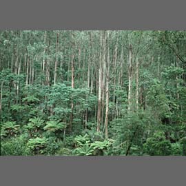