It’s Autumn in the Greater Blue Mountains, and the New South Wales Government’s bush arsonists are out in full swing deliberately setting fire to native habitat at every opportunity. Governmental ‘Habitat Reduction Season‘!
Is this pastime not comparable with the antiquated British imported tradition of the ‘Duck Season‘ – killing NATIVE ducks that is – just for sport. It’s the very same time of year!
“Capital climes for rough shooting old sport, what! Live on peg, we ought to bag a few dozen before tea.”
On Monday 25th March 2024, the NSW Government’s National Parks and Wildlife Service (NPWS) published a media release about its continuing “hazard” reduction burns across the Blue Mountains National Park. It read as follows (main extracts):
“The NSW National Parks and Wildlife Service (NPWS) has announced plans for an 850-hectare hazard reduction burn in the Glenbrook area of Blue Mountains National Park, set to commence on 26 March, weather conditions permitting. This preventive measure is part of a strategic effort to reduce the risk of wildfires and protect surrounding communities.
Scheduled to unfold over consecutive days, the operation targets the reduction of naturally accumulated fuel loads in the park. The primary aim is to provide strategic protection for the residential areas of Glenbrook, Lapstone, and Mulgoa against potential future wildfires.
…This burn is a component of the comprehensive hazard reduction program carried out by NPWS each year, often in collaboration with the Rural Fire Service and Fire and Rescue NSW. These operations are crucial for managing vegetation fuel loads and reducing the intensity and spread of potential wildfires.
The planned hazard reduction burns in Blue Mountains National Park underscore the ongoing commitment of NSW authorities to wildfire risk management and community safety. By taking proactive measures to manage fuel loads, the NPWS aims to mitigate the impact of wildfires, ensuring the protection of both natural landscapes and residential communities.”
Our comments to this bush arson justification spin doctoring:
The above is bush arson propaganda by contracted consultants with Communications Degrees, justifying the perpetual decimation of Australia’s native habitat since the first day of colonisation and usurpation of the continent since 1788. Nothing has changed or is likely to. Surviving intact wilderness has become reduced to mere islands. Just go to Google Maps [See our extract map below]
“850 hectares” is an area equivalent to about 30km x 30km (√ 850ha). In relative terms, that’s three times the size of Sydney’s CBD, a native habitat area capacity for many fauna;
“preventive measure is part of a strategic effort to reduce the risk of wildfires” – this is because when wildfires do occur the NSW Government invariably fails to (A) detect, (B) respond and (C) extinguish the ignitions promptly whilst small and controllable. It has an attitude that native habitat has a lower value than human habitat. In contrast, the urban Fire and Rescue Service is tasked to (B) respond and (C) extinguish the ignitions involving human property immediately, and unlike their unpaid volunteer Rural Fire Service (RFS) counterparts, they get paid to do it;
“protect surrounding communities” – this means human communities that have been built encroaching more and more into and usurping native habitat. These human “communities” are the only focus of the NPWS and its support RFS. Under this culture, wildlife communities matter not, irrespective of any threatened species impacted/killed. This attitude belies an antiquated anthropocentric mentality. Neither the NPWS nor the RFS employ an Ecologist. They just don’t care about protecting Ecology – in this case forest ecology;
“the operation targets the reduction of naturally accumulated fuel loads in the park“. That’s right, the NPWS as delegated custodial organisation ‘manager’ of the Blue Mountains National Park treats native habitat and its dependent fauna within such national parks in NSW (one of some 800) instead as “fuel loads” to be reduced to sterile urban park status. NPWS should be relegated to managing urban parks like Hyde Park in Sydney’s CBD;
“The primary aim is to provide strategic protection for the residential areas of Glenbrook, Lapstone, and Mulgoa against potential future wildfires.” – this is a reinforcement approach of our Point 3;
“…This burn is a component of the comprehensive hazard reduction program carried out by NPWS each year, often in collaboration with the Rural Fire Service and Fire and Rescue NSW.” – this is a reinforcement approach of our Point 3;
“These operations are crucial for managing vegetation fuel loads and reducing the intensity and spread of potential wildfires.” – “crucial” for whom? An expanding Sydney human housing sprawl? So the NSW Government’s volunteer and under-resourced RFS has less forested native habitat risk and so less work to do in the event of wildfires because year-on-year there is less forested native habitat left. Perpetuation that long term strategy, there will eventually be little or no native habitat left across NSW. So down the track a future NSW Government may well decide that the RFS is therefore no longer needed and so make the organisation redundant. Sydney that has been deliberately morphed by successive governments (state and federal) into the ‘Greater Sydney Region‘ has, on paper, swallowed whole the ‘Blue Mountains Region‘ (see NSW Planning map below) , presuming its world heritage status is now just outer-upper western Sydney parkland for the rezoning offing. Allowing the 2019 megafires to incinerate 80% of the Greater Blue Mountains World Heritage Area, clearly has achieved the NSW Government’s intended devaluation of the UNESCO recognised “Outstanding Universal Value” of all the Eucalypts, and is wholly consistent with a usurpation agenda for an even Greater Sydney megalopolis.
“The planned hazard reduction burns in Blue Mountains National Park underscore the ongoing commitment of NSW authorities to wildfire risk management and community safety. By taking proactive measures to manage fuel loads, the NPWS aims to mitigate the impact of wildfires, ensuring the protection of both natural landscapes and residential communities.” The spin doctoring clearly by outsourced consultants with Communication Degrees is palpable here. It’s more repetition of contrived persuasive terms: “planned hazard reduction burns”, underscore the “ongoing commitment of NSW authorities to wildfire risk management and community safety”. Ask the residents of Mount Wilson who lost their homes by RFS reckless arson in 2019 on this point! “taking proactive measures to manage fuel loads”, “the NPWS aims to mitigate the impact of wildfires”, “ensuring the protection of both natural landscapes and residential communities.” What so burning the natural landscapes to protect them? Seriously? In truth it is all about avoiding bad publicity when the RFS lights a high risk fire on 14th December 2014 causing homes to be incinerated like at Mount Wilson. “The state coroner has confirmed that a bushfire that destroyed homes in Mt Wilson, Mt Tomah, Berambing and Bilpin in December 2019 was caused after a planned RFS backburn jumped Mt Wilson Road.” [SOURCE: ‘Bushfire inquiry: Mt Wilson backburn to blame‘, BMG, 2nd April 2024]
RFS MOUNT WILSON ARSON: Sam Ramaci, like several of his neighbours, claims a back-burn lit by the RFS on December 14, 2019, was responsible for the destruction of his cool room, tractor and the property that was to fund his retirement. “If they hadn’t started the back-burn, my house would be still standing,” he said. (The NSW Government has refused to compensate him and others (nor even apologise) for the reckless misjudgment of its RFS – a NSW Government agency. Who can afford a class action? [Go to Video Link]
The Mount Wilson fire was the sixth backburn to escape along the southern containment line that was intended to protect the upper Blue Mountains from the Gospers Mountain Fire.
What sane person would join the Rural Fire Starters?
Bush arsonists have a psychological compulsion to set fire to see fire . It’s a ritual – they’re eyes light up. “Behold, The Fiery Cross !...”
NPWS is beholden to NSW Planning
A headline environmental protection agency that is supposed to be caring for national parks reporting to a state land use planning authority (aka Development). Is this a warped governmental portfolio conflict of interest of what? Liberal-Labor-Liberal…? Same Same.
The Regional Map of NSW according to the NSW Government’s Department of Planning and Environment fiefdom in 2024. Note that the Blue Mountains Region no longer exists, but has become annexed by the ever expanding ‘Greater Sydney Region’ in the mindset of Macquarie Street’s urban expansionism campaign. Mount Victoria a Sydney suburb now? Lookout Broken Hill!
Deforestation of Australia since colonisation and its usurpation from 1788. Remnant native forests and their native habitat have been decimated to ecologically unsustainable islands. The entire pre-colonial eastern seaboard of the continent was originally blanketed by native forests unbroken, extending about 600km inland. [SOURCE Google Maps – satellite view, April 2024]
It’s no wonder that Australia continues its record of perpetuating the world’s worst rate of wildlife extinctions. It’s akin to countries like Madagascar. It’s all hell bent on serving the Human Plague Order, currently 8.1 Billion! and in 2024 growing (and demanding more) by $75 million p.a. The current population of Australia is 26,654,200 as of Monday, April 29, 2024. Compare Australia’s Federation census of 1901 counted 3,773,801 people across Australia. [Check: Census Bureau Projects U.S. and World Populations on New Year’s Day; and ^https://www.worldometers.info/world-population/]
But wait there’s more bush arson planned…
An update last Friday, 26th April 2024 (just days ago), the NSW Government’s environmental department website again posted a media release advising of its further planned “Hazard reduction burn in Blue Mountains National Park” for the weekend.
It read as follows:
“The NSW National Parks and Wildlife Service (NPWS) with assistance from the NSW Rural Fire Service is conducting a hazard reduction burn in Blue Mountains National Park starting Sunday 28 April, weather permitting.
Staff from Metro South West and Blue Mountains regions undertaking the Pisgah Ridge hazard reduction burn near Glenbrook in the Blue Mountains National Park The hazard reduction burn will focus on an area south of Woodford, in the mid-mountains, and cover a total area of about 400 hectares. The burn aims to reduce fuel hazards and assist in the protection of property in the surrounding Woodford, Hazelbrook and Linden areas.
Fire trails around the burn area, including Bedford Creek, will be closed to the public, along with the Murphy’s Glen camping and day use area. The campground will be reopen when it is safe to do so.
Smoke may be seen in the area for up to a week after the initial operation.
The burn is one of many hazard reduction operations undertaken by NPWS each year, many with the assistance of the NSW Rural Fire Service (RFS) and Fire and Rescue NSW.
All burns around the state are coordinated with the NSW RFS to ensure the impact on the community is assessed at a regional level.
People with known health conditions can sign up to receive air quality reports, forecasts and alerts via email or SMS from the Department of Climate Change, Energy, the Environment and Water. For health information relating to smoke from bushfires and hazard reduction burns, visit NSW Health or Asthma Australia.
More information on hazard reduction activities is available at NSW Rural Fire Service and the NSW Government’s Hazards Near Me website and app.”
Asthma sufferers? – NSW Government care factor?
Carbon emissions? – NSW Government care factor?
10th December 2019: NPWS world heritage Eucalyptus woodsmoke enveloping Sydney from what started as an abandoned pile burn off Army Road near Gospers Mountain in the distant Wollemi NP two months prior on 26th October 2019. She’ll be right, eh NPWS boss David Crust?
The RFS is one of the planet’s highest emitters of airborne carbon particulates by way of causing mass wood-smoke by repeatedly lighting bushfires and ignoring wildfires. Wood smoke we feel is a tad more polluting than humans exhaling carbon dioxide. But then how many humans on the planet?
Yet the climate change cult remains quiet on this more serious global problem. Why so selective about a lesser pollutant in the hysterical ideology that has morphed from ‘Global Warming‘ (Wallace Smith Broecker’s term of 1975) to ‘The Greenhouse Effect‘ (Mike Hulme’s term in 1994) to ‘Climate Change Scientology‘ (U.S. National Academies of 2014) to currently ‘Climate Crisis‘ actually predating the former (U.S Vice President Al Gore of 2007).
The RFS and NPWS press on regardless – as it’s not carbon dioxide, so all good!
Here’s the latest bush arson schedule to further set fire to the still unburnt native habitat of the Blue Mountains:
RFS:“It’s ok love, it’s good for the bush. She’ll be right.”
It’s an age old mentality of the fox charged to look after the chickens. Both the NPWS and RFS have a cultural attitude that the national parks are NOT to be protected, despite the NPWS delegated to so-called manage NATIONAL parks across New South Wales (NSW). That is despite the Rural Fire Service (RFS) charged with putting out wildfires.
That perverted culture is conditioned to regard native habitat only as a ‘fuel’ that burns and so NOT habitat but a ‘hazard’ to be controlled and burned to prevent it burning. If there is no habitat left, then the meathead rationale, no hazard, so job done! Of recent times the spin doctors in government seconded as contractors with Communications Degrees (aka the art of spin) have softened the community sell of these ‘hazard reductions’ to ‘prescribed burns” to justify and take some noble authority from on high that the BUSH WAS ORDERED TO BE BURNED, WE HAVE NO CHOICE !
All their fire trucks are filled with more flammable liquids light a bushfire than water to put it out. ‘RFS’ should stand for for Rural Fire Starters.
Blue Mountains World Heritage?
Eventually the bush grows back but with a vastly different flora community make up. The biodiversity is gone. The wildlife don’t come back from the dead.
One of countless Koalas tragically burned to death in her native habitat during the Blue Mountains megafires of 2019. They won’t come back. [This website is not suitable for children to view]
This native Koala would have looked something like this:
National parks throughout Australia over the 236 years since colonisation and its continent-wide deforestation, land use destruction and introduced bushfires, have consistently and hatefully made Australia’s ecological landscape very very quiet and devoid of wildlife.
The 2019 mega bushfires of NSW that the NPWS and RFS let get out of control over months, wiped out 80% of the Greater Blue Mountains World Heritage Area, including rare remnant koala communities and hosts of other at-risk wildlife and their special native habitat that NPWS has no clue of the statistical losses. NPWS does not manage, it mismanages, else just oversees politically drive projects like multi-million dollar tourists track upgrades to benefit humans. The NSW State Government tasked to look after UNESCO world heritage on behalf of the Australia Government?
This habitat reduction regime is to burn the remaining 20% that didn’t cop the 2019 wildfire megablaze. They call this “stewardship”? All trust in the NSW Government to protect world heritage has long gone out the window.
The ‘NPWS’ is a misnomer
‘NPWS” is an abbreviation for the National Parks and Wildlife Service in the state of New South Wales.
Logo of the NPWS
The problem is that this government bureaucracy is supposed to be the governmental (public) custodian for national parks is misleading:
NPWS is not national, rather it is only a NSW governmental sub-department. Governmental ‘management’ of national parks is not national, rather each state and territory has its own national parks, and the Australian Government is not involved – so a bizarre and misleading naming tradition;
NPWS does NOT look after wildlife. Native habitat in these ‘national parks’ is supposed to be protected. Yet every year vast selected areas are burnt deliberately else left to burn on a grand scale, so killing wildlife and destroying their habitat.
As a consequence, the NPWS deserves to be more appropriately renamed as ‘NSW Parks Service‘ just like in Victoria, the Victorian Government calls its equivalent ‘Parks Victoria‘.
On the relevant NSW Government’s website pertaining to its NPWS, it explains that the NPWS is part of a sub-department called ‘Environment and Heritage, which in turn:
“Environment and Heritage is part of the Department of Climate Change, Energy, the Environment and Water.
Our vision is for a thriving, sustainable and resilient New South Wales.Environment and Heritage works with communities, businesses and governments to protect, preserve and strengthen the quality of our natural environment and heritage. We do this through active stewardship that supports a healthy New South Wales.We are committed to creating thriving environments, communities and economies that benefit the people of New South Wales.”
The three most trendy feel-good terms above include: “thriving”, “resilient” , active stewardship”. Pure motherhoodism by the contracted young spin doctors with a Communications Degree. So where are the published wildlife regional extinction stats before and after the Blue Mountains 2019 megablaze?
Recall Tathra Sunday 18 March 2018, the consequence of the RFS deliberately lighting a bushfire on a 38 degree Celsius (100 Fahrenheit) gusty day upwind of this coastal village. [Read Our Article: ‘Bushfire Scenario Was Not Rocket Science‘
[8] ‘Impact of the 2019-20 Mega-Fires on the Greater Blue Mountains World Heritage Area, New South Wales‘, 20221129, by P Smith and J Smith, Issue Vol. 144 (2022), Proceedings of the Linnean Society of New South Wales, ^https://openjournals.library.sydney.edu.au/LIN/article/view/17079
Location of Oxley Wild Rivers National ParkClick image to enlarge – note the patchy dark green of remnant forests
[Source: Satellite Map – Google Maps]
.
The ‘Macleay River’ Bushfire (Oct 2012)
.
Macleay River Bushfire October 2012
– left to burn for a week from 12th Oct 2012 because not a threat to private property
..then the wind picked up…unbelievable!
.
Over the past month, a single contiguous area covering some 60,000 hectares of vegetation has been left to burn by bushfire. That equates to 600 km2 or roughly 25km x 25km.
Much of what has been burned is/was of World Heritage values within the included Oxley Wild Rivers National Park. This is unacceptable custodial neglect.
If this was Sydney, this is the black boxed area that would have been incinerated:Putting this 60,000ha bushfire into a Sydney urban perspective
Professional urban fire fighting would not allow 60,000 hectares of private property and human lives to burn
– such would historically dwarf the Great Fire of London.
.
The Rural Fire Service has labelled the bushfire the ‘Macleay River Fire‘. But it began as two separate bushfires on or before 12 October, nearly a month prior. One was then labelled ‘Georges Junction Fire‘ and the other ‘Freds Creek Fire‘, both purportedly ignited by bush arsonist(s). Seven days later, the Georges Junction Fire has burnt an estimated 8,931 ha, while the then much smaller Freds Creek Fire had burnt 1,688 ha. By the time the combined bushfire was extinguished 60,000 hectares had been burned, much within the World Heritage Area..
This is yet another classic case of bushfire neglect primarily by the delegated custodians of the National Park and World Heritage Area – the New South Wales National Parks and Wildlife Service. Is this due to chronic lack of resourcing; and/or symptomatic of a disturbing rationalist culture that believes that burning Australian vegetation, even ancient rainforest, could be somehow beneficial to biodiversity.
Remote ignitions go undetected, then unsuppressed, until many days later, bushfire weather conditions worsen and the fires get out of control, combine and destroy vast areas of important Nationl Park and World Heritage.
This 2012 Macleay River Fire is like the ‘2006 Grose Valley Fires‘ of the Blue Mountains repeated to script.
The Australian Government continues to be ultimately culpable for gross neglect in failing to protect its custodial listed natural heritage.
The Rural Fire Service has learnt to avoid accusatioins of incompetence by routinely removing timely records on its websites about the operational response in the days at the start of the ignitions. Details about the timings of ignition detection and initial suppression are deliberately withheld from the public.
The following bushfire updates are mainly from second-hand news media. A notable recurring theme across these news reports is that the media interest and the target of the fire fighting effort, just like in urban fire fighting, is to save humans lives and property. This is not a bad thing, but the glaring omission is the lack of interest in suppressing the bushfire in the National Park and World Heritage.
The Rural Fire Service policy and operational strategy is such that if human lives and properrty are not directly threatened by bushfire, then a bushfire is allowed to continue burning, irrespective of whether it is burning through National Park or World Heritage. Since the Rural Fire Service has the same terms of reference as the professionaly paid New South Wales Fire Brigade, then they are essentially doing the same urban job.
The only reason the Rural Fire Service exists in less populated rural areas instead of the professionaly paid New South Wales Fire Brigade, is traditionally so that the Australian Government and New South Wales Government can save money by relying on unpaid, under-resourced volunteers. Yet the environment in rural fire fighters work in is inherently more dangerous, demanding and in need of sophisticated resources for military-speed detection and suppressions of bushfires.
.
21 Oct: Bushfire Update
.
‘Blazes burn out of control: Permits suspended as hot, dry weather hits North West’
Satellite infrared image of the fire called Georges Junction inside the Oxley Wild Rivers National Park
Having already burnt out a massive 14,000 hectares and is likely to join up with the Freds Creek fire.
The active edge of the fire shows up bright yellow; the red areas are the burnt areas.
(Photo by New England RFS)
.
<<Two massive bushfires in the Oxley Wild Rivers National Park were basically running unchecked yesterday because of adverse firefighting conditions, incident controller for the New England bushfire emergency, Allyn Purkiss, said.
Mr Purkiss said the two Section 44-declared fires one named Freds Creek and the other Georges Junction were likely to join up yesterday and burn out a total of 30,000 hectares in the coming weeks.
“They took a big run under strong winds (on Saturday)..The fires had started after landholder burns had got away”, Mr Purkiss said.
..The fire named Freds Creek, which started on October 12, had burnt out 3,189 hectares and was crowning at 4am yesterday, with flames jumping from treetop to treetop.
“It means it’s very uncontrollable very dangerous conditions,” Mr Purkiss said yesterday.
The RFS had been unable to aerial-bomb the fires because of gusty winds. Mr Purkiss described it as “nigh-on impossible” to water-bomb in those conditions.
Instead, RFS volunteers had concentrated on saving property. He said it was hard to tell how many homes and remote-area shacks might be affected.
“We’re still trying to come to terms with that. We could have up to 50 in the area: there are shacks all through this country,” he said.
Mr Purkiss said the other fire, Georges Junction, had already burnt out 14,000 hectares. (Ed: Same as the 2006 Grose Valley Fires).
He said conditions in the New England RFS zone were “fairly similar” to strong, gusty winds on Saturday. “The forecast is for 50km/h winds by late afternoon,” Mr Purkiss said.
No homes had been lost in either fire yet. “None that we know of,” he said. The RFS was doing a “fairly extensive reconnaissance of the area”, he said.
Three other fires one about 40km east of Guyra, one near Walcha and one near Ebor had also started since Friday.
The Guyra fire, which started on Saturday, was located in the Mt Mulligan/Wards Mistake area.
Locals had alerted the RFS to the fire, which was in “very remote country … it’s difficult to get to no roads, no trails”, Mr Purkiss said.
“I’ve tasked an aircraft to get out there today and map it and give us some intel (intelligence),” he said..
“No properties were under threat: it was burning in scrub.“
.
Mr Purkiss said he was “not sure” how much land had been burnt out he would have to wait for information provided by the aircraft crew.
The Walcha fire, called Panhandle and in the Enfield State Forest, had burnt out five hectares by the time it was contained by mid-afternoon on Saturday.
The Ebor-area fire was located “in an area we can’t get to”, Mr Purkiss said. “We’re flying to map it today,” he said yesterday.
It had also burnt out five hectares.
“Local landholders and Ebor RFS assisted in containing it,” he said.
Mr Purkiss said the New England RFS zone was unlikely to lift its suspension of fire permits today.
“While ever we have a bushfire emergency like this going, all permits are suspended we’re already dealing with enough fires, so we don’t need any more mistakes giving us grief than we already have,” he said.
Mr Purkiss said this season had already started to play out differently compared to the past three years.
In the past three fire seasons, rain had usually come along and helped extinguish any fires but this season was different, with many more periods of extended dry weather.
“In talking to the local staff, they say that this (Georges Junction) is the largest fire they have had since 2009,” Mr Purkiss said. “We’re working hard to get it done. We thank the volunteers and employers for allowing us to fight these very large fires.”>>
<<Fire continues to threaten properties near Oxley Wild Rivers National Park after two blazes combined yesterday.
The Macleay River bushfire had already burnt about 20,000 hectares early yesterday afternoon as more than 30 firefighters battled the out of control blaze, NSW Rural Fire Service spokeswoman Bridie O’Connor said.
The inferno may have posed a threat to properties between Georges Junction and Five Day Creek, particularly on the Carrai and Fitzroy Tablelands and on the Macleay River in the vicinity of Lower Creek and Comara, Ms O’Connor said early yesterday afternoon.
“We’re looking at a minimum of six hours before some properties might be affected,” she said. “People should expect to see smoke and fire and be alert.”
Hot and windy conditions over the weekend (20th and 21st) saw the fires at Georges Junction and Freds Creek combine.
The Georges Junction fire, near Cochrane State Forest, which started on October 12 had burnt more than 14,859 hectares and was still burning out of control when it met with the Freds Creek fire early yesterday afternoon. The fire at Freds Creek was being controlled yesterday afternoon after three State Forest groups joined the NSW Rural Fire Service to use bulldozers to create fire breaks earlier in the week.
Meanwhile, the Armidale to Kempsey Road between Waterfall Way and Bellbrook was closed on Saturday and Sunday because of the fires.
The Rural Fire Service was concentrating its efforts on establishing containment lines.
People on properties near Georges Junction and on the Macleay were urged to be alert for fire warnings.>>
.
23 Oct: Bushfire Update
.
‘Total fire bans expected back in place by Thursday’
<<…Adverse weather conditions on Sunday hindered attempts to subdue two massive bushfires in the Oxley Wild Rivers National Park. Fire crews were reduced to protecting property on the ground and the two fires merged late on Sunday as fire crews battled from the ground to protect property, unable to water bomb due to gusty winds across the region.
The fire, now named the Macleay River Fire had burnt out 28,733 hectares as of last night, Inspector Brett Loughlin, public liaison officer for Armidale Section 44 with the NSW Rural Fire Service, said.
Mr Loughlin was expecting the fire to burn out more land.
“We’re doing some mapping now and expect it to be around that 30,000-hectare mark,” he said. He said 52 firefighters were on the ground creating firebreaks, doing backburning and helping protect the property of landholders living within a few kilometres of the fire front.
“There are properties in close proximity,” Mr Loughlin said. “The fire has flared up a little this afternoon and some embers are falling around properties in the Lower Creek area.
“No property is under threat at the moment … the fire’s not doing anything like it was doing on Saturday (when it was out of control – a day of hot, gusty westerly winds).”
Five helicopters are currently tasked to water bombing the Macleay River Fire.
Oxley Wild Rivers National Park is still shut to the public…>>
<<Rural Fire Service forensic investigators have interviewed a ‘person of interest’ as the battle to contain the Macleay River fire enters its 15th day.
RFS investigators from Kempsey and Coffs Harbour arrived yesterday to investigate the possible cause of the blaze in the Oxley Wild Rivers National Park which has since burnt out 33,160 hectares of bush and pasture land.
RFS Public Liason Officer Inspector Brett Loughlin said all major fires were investigated as a matter of cause and investigations were ongoing.
Around 80 firefighters from the NSW RFS, FRNSW and NPWS, supported by five aircraft and four bulldozers are fighting the fire, which has a 247 kilometre perimeter.
Ember attack on properties around the Lower Creek area were reported yesterday but Inspector Loughlin said that firefighters were working with local landholders to protect at-risk homes.
Inspector Loughlin said that good containment lines had been established by fire crews in the last 24 hours and today “aerial incendiary” work by helicopter would be carried out on the south western side of the blaze. “It’s still an active fire but we’re starting to get a handle on it,” Inspector Loughlin said.
The Macleay River Fire is the culmination of the ‘Freds Creek Bushfire‘ and ‘Georges Junction Bushfire‘ that had merged last weekend. The fire is burning in the vicinity of the Comara, Georges Junction, Five Day Creek, Lower Creek, Blanches Creek and Smith Creek areas.
Another fire burning near Guyra, has been contained. The ‘Mulligans Bushfire‘, which has burnt out 3207 hectares near the Guy Fawkes National Park has been burning since Saturday.>>
Macleay River Bushfire
(Photo by Sean Bremmer)
.
1 Nov: Bushfire Update
.
Rural Fire Service Reported Operational Statistics:
‘MACLEAY RIVER FIRE‘
ALERT LEVEL: Advice
LOCATION: 50 kms east of Armidale, 75 kms west of Kempsey, 65kms east of Walcha
COUNCIL AREA: Armidale Dumaresq
STATUS: Being Controlled (Ed: glass half-full spin)
TYPE: Bush fire
FIRE: Yes
SIZE: 51,405 ha
RESPONSIBLE AGENCY: Rural Fire Service
UPDATED: 1 Nov 2012 15:25
<<Three local government areas have been declared natural disaster zones in the wake of a major fire that has been raging in northern NSW for two weeks.
The massive front formed on October 21 when the Freds Creek and Georges Junction fires combined at the Macleay River. It has damaged over 51,000 hectares of:
National Parks
State Forests
Private Land
.
across three shires:
Armidale Dumaresq shire‘
Walcha shire
Kempsey shire
.
“These fires have been burning in the area for a number of days and due to the conditions, they merged into one large fire, jumped containment lines and threatened numerous properties,” Emergency Services Minister Michael Gallacher said in a statement on Monday.
“This declaration triggers a number of disaster assistance schemes to assist with the cost of disaster relief and recovery.”
Over the last two weeks, bushfires have raged across the New England and Mid North Coast regions. Other fires under this declaration include the Clay fire in Armidale Dumaresq, the Panhandle fire in Walcha and the Mulligans fire in Guyra on the western side of Guy Fawkes National Park, which has burnt over 3,400 hectares of National Park and private land.
Mr Gallacher said the Macleay River fire had damaged significant portions of the Oxley Wild Rivers National Park, which is part of the Gondwana Rainforests of Australia World Heritage Area, a series of protected areas which were first inscribed on the World Heritage List in 1986 and extended in 1994.
.
5 Nov: Bushfire Update
.
<<Three separate fires burning out of control south-west of Casino since the weekend have been contained, the Clarence Valley Rural Fire District reports.
The ‘Dubadar Creek Bushfire‘, which was believed to have been started by arsonists before blowing out from 50ha to 300ha on Saturday, was contained on Sunday and was extinguished at midday today, the district’s incident controller Stuart Watts said.
Two separate blazes, also deliberately lit, at Mt Pickabooba 4km from the Dubadar Creek fire were expected to be contained by this afternoon following back-burning, Mr Watts said. The Rural Fire Service had 10 fire trucks, 19 personnel and two bulldozers working to bring the fires under control on the weekend. The Northern Star has approached the police for comment.
The battle with the blazes come as NSW Police and Emergency Services Minister Michael Gallacher declared natural disasters for the Mid North Coast – parts of which only a year ago were receiving the same declaration for floods – and New England areas.
“The main focus of this declaration is the Macleay River Fire, which developed on 21 October 2012 as the culmination of the Fred’s Creek and Georges Junction Fires,” Mr Gallacher said in a written statement.
“These fires have been burning in the area for a number of days and due to the conditions, they merged into one large fire, jumped containment lines and threatened numerous properties…Firefighters have been working hard to create containment lines around the Macleay River Fire to protect properties as the fire approaches.
“As of 1 November 2012, the Macleay River Fire continues to burn and is estimated to have damaged over 51,000 hectares of National Parks, State Forests and private land across the three LGA’s of Armidale Dumaresq, Walcha and Kempsey.
“The Macleay River Fire has damaged significant portions of the Oxley Wild Rivers National Park, which is part of the Gondwana Rainforests of Australia World Heritage Area, a series of protected areas which were first inscribed on the World Heritage List in 1986 and extended in 1994.“>>
.
Reader Comment:
by ‘coco50’ from Ballina 20111105:
<<When is our judicial system going to get serious about arsonists? It is difficult enough to catch them. Think about what they do. They destroy natural bushland and animal habitat. They put the lives of people at risk or even cause deaths. They destroy property which causes hardship and suffering and years to rebuild. This pushes up everyone’s insurance premiums. They out emergency services personnel at risk.
But when we get an arsonist in court, the defence counsel makes an argument like: “My client had a difficult childhood – his parents and peers didn’t understand him. He is remorseful”
The Judge almost cries while handing out a “slap on the wrist” sentence. It is much harder to start a fire in jail while you are doing 20 years time. Lock them up!>>
‘MACLEAY RIVER BUSHFIRE’
ALERT LEVEL: Advice
LOCATION: 65km East of Walcha
COUNCIL AREA: Armidale Dumaresq
STATUS: Being Controlled
TYPE: Bush fire
FIRE: Yes
SIZE: 59, 663 ha
RESPONSIBLE AGENCY: Rural Fire Service
UPDATED: 6 Nov 2012 09:10
.
Oxley Wild Rivers National Park is World Heritage‘protected‘
.
1986: Gondwana Rainforests of Australia inscribed on the World Heritage List.
.
World Heritage Listing because local people thought it was so important to save before it was gone
.
Over twenty-five years ago, in 1986 the Gondwana Rainforests of Australia, then called the Central Eastern Rainforest Reserves of Australia (CERRA), were inscribed on the World Heritage List for their outstanding natural universal values.
Theses rainforest comprise the Great Escarpment of eastern New South Wales, then known as the Australian East Coast Sub-tropical and Temperate Rainforest Parks, were inscribed on the World Heritage list meeting the following three World Heritage Natural Criteria:
Outstanding example representing significant ongoing geological processes and biological evolution (World Heritage Natural Criterion viii)
Outstanding example representing major stages of the earth’s evolutionary history (World Heritage Natural Criterion ix)
Containing important and significant habitats for the in situ conservation of biological diversity (World Heritage Natural Criterion x)
The Gondwana Rainforests contains the largest and most significant remaining stands of subtropical rainforest and Antarctic Beech (Nothofagus moorei) cool temperate rainforests in the world, the largest and most significant areas of warm temperate rainforest and one of only two remaining large areas of Araucarian rainforest in Australia.
Enormous Antarctic Beech (Nothofagus moorei)
At Cobark Park, Barrington Tops, 50 metres tall
.
The Gondwana Rainforests of Australia is a serial property comprising the major remaining areas of rainforest in southeast Queensland and northeast New South Wales. They include the most extensive areas of subtropical rainforest in the world, large areas of warm temperate rainforest and nearly all of the Antarctic beech cool temperate rainforest. Some of the oldest elements of the world’s ferns and conifers are found here and there is a concentration of primitive plant families that are direct links with the birth and spread of flowering plants over 100 million years ago.
A wide range of plant and animal lineages and communities with ancient origins in Gondwana, many of which are restricted largely or entirely to the Gondwana Rainforests, survive in this collection of reserves. The Gondwana Rainforests also provides the principal habitat for many threatened species of plants and animals.
The area is one of the best places on earth to see ancient ferns and Araucaria such as Hoop Pines.
Hoop Pine
(Araucaria cunninghamii)
Found naturally in the dry rainforests of New South Wales and Queensland and in Papua New Guinea.
The trees can live up to 450 years and grow to a height of 60 m.
.
Rainforest once covered most of the ancient southern supercontinent Gondwana and remains the most ancient type of vegetation in Australia. The Gondwana Rainforests provide an interesting living link with the evolution of Australia. Few places on earth contain so many plants and animals which remain relatively unchanged from their ancestors in the fossil record.
Due to two centuries of colonial deforestation across New South Wales and Queensland – timbergetting, ‘land clearing’ for agriculture and housing – the reserves of rainforest that comprise The Gondwana Rainforests in discontinuous patches, surrounded by fireprone eucalypt forest and cleared agricultural lands.
These patches range in size from tiny gully stands to lush forests covering large valleys and ranges. Collectively, these ‘serial sites’ despite their small size and scattered fragments, provide proximity and interconnection by corridors of semi-natural habitats and buffers. Their natural asset value is fragile and demands intensive management and protection in order to preserve their ecological integrity.
The ecosystems of the Gondwana Rainforests contain significant and important natural habitats for species of conservation significance (World Heritage Natural Criterion x).
The Gondwana Rainforests provides the principal habitat for many species of plants and animals of outstanding universal value, including more than 270 threatened species as well as relict and primitive taxa. Many of the rare and threatened flora and fauna species are rainforest specialists, and their vulnerability to extinction is due to a variety of factors including the rarity of their rainforest habitat.
The Gondwana Rainforests also protects large areas of other vegetation including a diverse range of heaths, rocky outcrop communities, forests and woodlands. These communities have a high diversity of plants and animals that add greatly to the value of the Gondwana Rainforests as habitat for rare, threatened and endemic species. The complex dynamics between rainforests and tall open forest particularly demonstrates the close evolutionary and ecological links between these communities.
Species continue to be discovered in the property including the re-discovery of two mammal species previously thought to have been extinct:
The Hastings River Mouse (Pseudomys oralis)
Parma Wallaby (Macropus parma)
Parma Wallaby (Macropus parma)
Endemic to rainforests and sclerophyll forests in New South Wales from the Watagan Mountains in the South to the Gibraltar Range in the North.
Parma wallabies were thought to have become extinct a century ago until being discovered again in the 1970s.
.
1994: Oxley Wild Rivers NP added to World Heritage
.
In 1994, large extensions of rainforests across south-east Queensland and New South Wales including the Oxley Wild Rivers National Park were added to the World Heritage listed Central Eastern Rainforest Reserves of Australia (CERRA), now entitled The Gondwana Rainforests of Australia (since 2007).
OxleyWild Rivers National Park – location map
[Source: Google Maps]
.
These reserves comprise almost 50 separate remnant reserves of unspoilt rainforest wilderness stretching from north-east New South Wales (the Oxley Rivers region) up through south-east Queensland. Each of these reserves contains important nature conservation values in its own right, however the full significance of the property becomes evident only when viewed as a whole, and collectively CERRA provides a significant network of habitats for many of Australia’s rare and endangered species.
Since 1994, the Australian Government in co-operation with both the New South Wales and Queensland Governments have recognised the need for coordinated, consistent and cooperative management, to ensure that the integrity of CERRA‘s values is protected. At the time, the World Heritage Committee requested the Australian Government complete management plans of individual sites. Six years later in 2000, the Australian Government published its ‘Strategic Overview for Management for the Central Eastern Rainforest Reserves of Australia to guide co-operative management by the three Governments in relation to the identification, protection, conservation, rehabilitation and presentation of the Gondwana Rainforests. In 2002, a Technical and Scientific Advisory Committee and a Community Advisory Committee were established.
The Gondwana Rainforests of Australia are managed principally by the New South Wales National Parks and Wildlife Service (part of the New South Wales Department of Environment and Climate Change) and the Queensland Environmental Protection Agency.
Later 1,850 ha of Winterbourne State Forest, also known at the Big Lease, was added to the reserves wilderness. Currently (2012), the remaining 1,560 ha of Winterbourne and 1,075 ha of Enmore State Forests are to be added to the National Park. Further inclusions include Green Gully headwaters and 1,439 ha of leasehold land in the lower Chandlers River gorge.
The Macleay Gorges Wilderness Area, covering 50,000 hectares, was declared World Heritage in 1996 and further extended in 1997.
In 2007, Macleay Gorges Wilderness Area and Oxley Wild Rivers National Park, along with the 50 separate Crown Land reserves of remnant ancient rainforest were collectively renamed under the umbrella term Gondwana Rainforests of Australia to better reflect their World Heritage values. These include important rainforested areas between Newcastle and Brisbane from Mount Royal National Park and Banrrington Tops National Park to Lamington National Park inland of Queensland’s Gold Coast.
Aspley Falls in flood
Oxley Wild Rivers National Park
.
High waterfalls crashing into steep gorges are spectacular examples of an important ongoing natural process – erosion. Erosion by coastal rivers created the Great Escarpment and the steep-sided caldera of the Tweed Valley surrounding Mount Warning. This towering mountain was once the buried plug of an ancient vast volcano. Today, rainforest grows on the fertile, well watered soils that remain.
The Macleay River on the Mid North Coast of New South Wales, Australia, has the world’s second-fastest flowing currents during flooding, when it can hold over 200,000 gigalitres.
Its headwaters flows from the Gara River on the eastern side of the Northern Tablelands near the tonwships of Armidale and Walcha. Key tributaries are the Chandler River, Styx River and Apsley River as well as the Tia River, Dyke River and Yarrowitch River, which pass through a number of spectacular gorges and waterfalls in the Oxley Wild Rivers National Park.
The Macleay River flows 400km south-east through Kempsey and into the Pacific Ocean at South West Rocks. Upon colonial discovery in the 1820s; the ancient, tall native Red Cedar (Toona ciliata) forests were completely deforested.
Australian Red Cedar Forest
Tamborine National Park, Gold Coast Hinterland, Queensland
(such trees have long been logged through the Oxley Rivers region)
.
In 1976, the Apsley Macleay Gorges were identified as being of ‘true wilderness quality‘.
At that stage the public protection offered to the area was limited to two small reserves in the south, and a few local council run recreation areas at popular sites such as Wollomombi Falls, Dangars and Apsley Falls. With future land-use undecided, the NSW Electricity Commission began surveying the Apsley Valley for a hydro-electric scheme in the late 1970s. The Apsley Gorge National Park of 6,718 hectares was gazetted followed by the 3,456 hectare Yarrowitch Gorge National Park soon after.
In 1989 East Kunderang Station of 30,400 hectares passed to the National Parks and Wildlife Service (NPWS) and was proclaimed the Oxley Wild Rivers National Park.
.
Rich Wildlife through Oxley Wild Rivers National Park
.
Oxley Wild Rivers National Park is rich in fauna, with over 350 species recorded, including 55 mammals.
It is a major refuge for the Brush-tailed Rock-wallaby (Petrogale pencillata), with the largest confirmed population in the Green Gully area of Yarrowitch.
.
Brush-tailed Rock Wallaby (Petrogale penicillata) in Oxley Wild Rivers National Park
This species is listed in New South Wales as ‘Vulnerable to extinction’, but that was by the NSW Scientific Committee in 2003, nine years ago
There have been two major bushfires through since then – one in 2009 and now in 2012
How many viable individuals have been lost to the Macleay River Bushfire – does the NSW NPWS know or care?
.
<<Oxley Wild Rivers National Park, including Green Gully Track, is closed until further notice due to wildfire.>>
Over 173 bird species, 38 reptile and 19 amphibian species have been recorded in Oxley Wild Rivers National Park.
Skinks, goannas, tortoises, lizards, snakes, frogs and fish occur in the park, particularly on the river flats. A number of fish species have been recorded. Notable, is the speckled longfin eel (Anguilla reinhardtii), which breeds in the ocean with the juveniles eventually returning to the Apsley–Macleay River system.
There are fourteen known threatened species within the Oxley Wild Rivers National Park:
All these wildlife were previously widespread, but now are vulnerable to extinction or worse; which has become an Australian cliché, but at the same time an indictment on Australians.
But how much of this protected wilderness region is left after last fortnight’s bushfire catastrophe?
How can it be deemed to be protected, when bushfire is allowed to ravage it and its vitally recognised flora and fauna? Was the World Heritage Area allowed to burn as a convenient bushfire management operational defacto Hazard Reduction? There were no human assets at risk. It was wilderness and so out of sight out of mind…such is the dominant bushphobic culture of the Australian and State Governments, so accused of neglect and incompetence after the 2009 Victorian Bushfires that killed 173 people.
To current anthropocentric (20th C babyboomer) governments, this ‘Macleay River Fire’, irrespective of its World Heritage ecological protection, is blanketly and culturally dismissed as just another hazardous fuel region to target within Australia’s continent-wide Government Arson strategy. Successive generations will revisit this prevailing cultural mindset of ‘hazard reduction‘ and cast it alongside 19th C ‘timbergetting‘ and 20th C ‘clearfelling‘.
In the Blue Mountains, some 40,000 hectares of native vegetation is currently approved by the same Australian and New South Wales Governments for deliberate burning.
If deliberately setting fire to the native vegetation is committed privately it is deemed bush arson and so attracts a poultry 14 years gaol or less even less, despite people having been burned to death as a direct consequence.
But if deliberately setting fire to the native vegetation is previously prescribed by Government, then participants are artificially deemed legally immune and impune from criminal liability, even if the prescribed bushfires they light get out of control, which is all too frequently.
The Australian Government’s official public relations message reads:
Institutional arrangements for the protection and management of Gondwana Rainforests are strong. The property is made up of 41 reserves, almost all of which are within the protected area estate, and primarily managed by the Queensland Parks and Wildlife Service and the New South Wales National Parks and Wildlife Service. Both States have legislation relating to protected areas and native flora and fauna that provide protection for the values of the Gondwana Rainforests.
All World Heritage properties in Australia are ‘matters of national environmental significance’ protected and managed under national legislation, the Environment Protection and Biodiversity Conservation Act 1999. This Act is the statutory instrument for implementing Australia’s obligations under a number of multilateral environmental agreements including the World Heritage Convention. By law, any action that has, will have or is likely to have a significant impact on the World Heritage values of a World Heritage property must be referred to the responsible Minister for consideration. Substantial penalties apply for taking such an action without approval. Once a heritage place is listed, the Act provides for the preparation of management plans which set out the significant heritage aspects of the place and how the values of the site will be managed.
National Heritage is also a matter of national environmental significance under the EPBC Act.
Importantly, this Act also aims to protect matters of national environmental significance, such as World Heritage properties, from impacts even if they originate outside the property or if the values of the property are mobile (as in fauna). It thus forms an additional layer of protection designed to protect values of World Heritage properties from external impacts.
The impacts of climate change and high levels of visitation, undertaking effective fire management, and mitigating the effects of invasion by pest species and pathogens present the greatest challenges for the protection and management of Gondwana Rainforests.
Climate change will impact particularly on those relict species in restricted habitats at higher altitudes, where particular microclimatic conditions have enabled these species to survive.
Management responses include improving the resilience of the property by addressing other threats such as inappropriate fire regimes and invasion by pest species, and trying to increase habitat connectivity across the landscape.
[Source: Australian Government, ^http://www.environment.gov.au/heritage/places/world/gondwana/values.html]
.
Recall 2009: 9,500 hectares of Oxley Wild Rivers left to burn
.
In December 2009, a lightning strike started a bushfire in the Youdales Hut area of the Oxley Wild Rivers region. The hut was unaffected (human property?), but 1,500 hectares of inaccessible steep country was burnt out before it was brought under control.
Another lightning strike started a large bushfire in the Reedy Creek region of the park. This fire has burnt out over 8,000 hectares of rough country.
.
[Ed: Yes, steep wilderness terrain without convenient fire trails carved through it, is naturally inaccessible to lumbering urban fire trucks – so RFS/NPWS where were the waterbombing aircraft on 12th Oct 2012, when the fires were tiny and manageable?]
..the evening news media dramatises a forthcoming government declaration of a‘Total Fire Ban’. Next day yep, dry and hot, then early afternoon wind picks up. Yep, having mapped target, and with no-one around, opportunity to be ‘Bushfire Hero’…
.
7th Feb 2009, 1:30pm – a pine plantation near Churchill, West Gippsland:
Of the thousands of bushfires that burn Australia’s natural landscape each year, humans cause the vast majority, with somewhere around half of these being deliberately lit, that is, not by accident.
Bush Arson is a serious and heinous crime now systemic in bushfire-prone Australia, California and southern forested regions of Europe. It is committed usually by misfit serial offenders, yet despite the statistics, across all states in Australia from Tasmania to the Top End, the crime remains largely given lip service by governments.
Researchers at the Australian Institute of Criminology have assessed that there are many reasons why people light fires. While some want to relieve boredom by creating havoc and excitement, other arsonists crave recognition or attention. Some light fires out of anger or protest while others believe they are being altruistic by clearing what they see as dangerous fuel-loads. Sometimes there are multiple motives.
People who light fires for excitement will often stay around after the fire to view their handiwork, which suggests that fire crews should look around and talk to the people who are there watching. Knowing that some people light fires just so they can treated as a hero if they report the fire or put it out is also useful, especially for fire services screening new members.
Some of those people who light those fires do become members of fire services, and this needs to be a consideration in the firefighting recruitment process.
The 2009 Victorian Bushfires, collectively branded by the media as ‘Black Saturday’, involved far many more bushfires that the ones that ignited and reported by the media on Saturday 7th February 2009.
‘The number of fires that had not been extinguished rose from seven on New Year’s Day to 29 on 14 January. Then it doubled to 58 by 25 January and continued to steadily increase to 125 in the week before 7 February. By this time firefighting resources had been committed for a fortnight responding to new fires and attending to fires already contained or controlled.’
[Source: ‘The Number of Fires’ in Overview, Part One: ‘The January-February 2009 Fires’, Vol I: ‘The Fires and the Fire-Related Deaths’ p.4 citing the Department of Sustainability and Environment – Annual Report 2009 (TEN.201.001.0001) at 0047, in Final Report, July 2010, Vol. 1, p.20, by 2009 Victorian Bushfires Royal Commission, State Government of Victoria ]
.
According to the Victoria Country Fire Authority, of the fires that were not readily contained on or before 7 February, 14 of those 47 became ‘major fires’. On 7th February alone however, the CFA indicated there were a total of 1386 incidents reported on 7 February — 592 grass and bushfires, 263 structure fires and 156 reported incidents that were false alarms.
.
[Ed: Clearly the bushfire conditions were extreme (beyond the usual ‘Total Fire Ban’ severity), the number and distribution of bushfires were considerable and emergency resources were overwhelmed. So for bush arson to be committed on such a declared day was beyond arson; it was ‘pyroterrorism’. But the crime does not yet feature in the Crimes Act. It needs to be. The penalty needs to be equated to that which would be imposed upon a terrorist attempting or actually causing mass murder. It is past time that Australia’s lackadaisical and euphemistic term ‘fire bug‘ is cast to history. We owe this to the memory and respect of 173 people lost. What is significant is that of the 173 who died, most were due to either arson or powerline spark – both human caused].
.
The bushfires associated with Black Saturday that were selected to be investigated by the Victorian Royal Commission were on the basis of fires having caused the death of the 173 people and/or where significant damage had occurred.
.
2009 Bushfires investigated by the Royal Commission
The investigated bushfires numbered twelve and they were:
Kilmore East Bushfire
Murrindindi Bushfire
Churchill Bushfire
Delburn Bushfire
Bunyip Bushfire
Narre Warren Bushfire
Beechworth-Mudgegonga Bushfire
Bendigo Bushfire
Redesdale Bushfire
Coleraine Bushfire
Horsham Bushfire
Pomborneit–Weerite Bushfire
.
[Ed: NOTE: We include the suffix ‘bushfire’ above, unlike the Royal Commission in its literature which abbreviates ‘bushfire’ just to ‘fire’, or even drops the reference to fire completely, bless their imported cotton socks].
2009 Victorian Bushfires – Overview Map
.
It is instructive to emphasise that the eventual naming of these fires was based on the point of origin, however on the day it had proven problematic during the overwhelming speed and complexity of the multiple simultaneous bushfire emergencies.
The lead item in the Terms of Reference for the Victorian Royal Commission was sensibly to inquire into ‘the causes and circumstances of these bushfires‘.
.
The Bushfires Deliberately Lit *
.
Of the above 12 bushfires investigated, those known or suspected to have been caused by arson or otherwise in obscure firefighting-speak ‘undetermined‘ or ‘unknown‘ were:
Murrundindi Bushfire
Delburn Bushfire
Redesdale Bushfire
Upper Ferntree Gully Bushfire
Bendigo Bushfire
Churchill Bushfire
.
*Various vague assessments as to cause included ‘suspicious’, ‘unknown’, ‘undetermined’, which in 2012 is unacceptable. Compare the term ‘undetermined‘ to any police investigation into an urban fire causing significant damage; such a vague dismissal would be publicly unacceptable. So in the absence of competent investigation, we shall presume bush arson. So half were caused by arson, which is in line with the Australian Institute of Criminology’s conclusions, above.
.
The Murrindindi Bushfire
With bushfire conditions extreme (temperature 44.6°C, humidity 8%, wind 46kph, Bushfire Index 110 – off the scale), the bushfire started about 14:55 on 7 February 2009, to the north of a sawmill in Wilhelmina Falls Road, Murrindindi. The cause was assessed as ‘suspicious’.
After the bushfire had merged with the Kilmore East Bushfire some 168,542 hectares had been burnt. Forty people were killed, another 73 people were injured, 538 houses were destroyed or damaged, mainly in and around Marysville, Narbethong and Buxton. The commercial centre of Marysville was razed to the ground. Firefighting resources involved 195 CFA and 311 NEO personnel, supported by 45 CFA appliances, 22 Networked Emergency Organisation (NEO)* appliances and 3 aircraft.
* [Ed: Networked Emergency Organisation? – a rather new convoluted bureaucratic term given to the Royal Commission to collectively represent a mix of disparate government agencies quickly cobbled together to deal with an emergency outside the control of the Country Fire Authority volunteer base].
.
The Delburn Bushfire
With bushfire conditions similarly extreme, albeit with a lower Fire Index of 52, this bushfire started as three separate ignitions in the Strzelecki Ranges on 28 and 29 January 2009:
The Ashfords Road Bushfire – discovered on 28 January at about 4.00 pm, 2.5 kilometres north-north-west of Boolarra.
The Creamery Road Bushfire – discovered at about 1.00 pm on 29 January, 2.5 kilometres east of Delburn.
The Lyrebird Walk–Darlimurla Bushfire – discovered at about 3.30 pm on 29 January, 4 kilometres north of Mirboo North near Darlimurla.
.
[Ed: So each started under extreme bushfire conditions in the early afternoon]
.
The causes of both the above Creamery Road Bushfire and the Lyrebird Walk–Darlimurla Bushfire were assessed as ‘suspicious’ and the Victorian Police have since laid criminal charges against the suspected arsonist.
The three separate bushfires were not contained and ultimately merged. Increasing wind and changes in wind direction caused spotting and resulted in the bushfire spreading quickly east towards the outskirts of the townships of Boolarra and Yinnar. The surrounding townships included Mirboo North (population 1,300), Boolarra (pop. 600), Yinnar (pop. 600) and Churchill (pop. 5,000). Fortunately there were no fatalities or casualties, but 44 houses were destroyed maily on the outskirts of Boolarra, and some 6,534 hectares burnt out. Firefighting resources involved 597 CFA and 699 NEO personnel, supported by 112 CFA appliances, 103 NEO appliances and 14 aircraft.
Delburn Bushfire 30th January 2009 from NASA satellite
.
There had been a further three ignitions around the time (1) at the Delburn–Yinnar refuse transfer station, (2) at Ten Mile Creek Rd in a Hancock Victoria Plantation and (3) at Brewsters Rd, Yinnar. Each was either contained or burnt out without fire-fighting intervention.
.The 2009 Delburn Bushfire
A CFA firefighter runs out hose on Piggery Road at Boolarra 2nd February 2009.
(Photo by Greg Cahir)
.
The Redesdale Bushfire
The Redesdale Bushfire started with similar bushfire conditions (temperatures reaching 44.7°C, humidity 7%, winds up to 50kph, Bushfire Index 87.2). The bushfire was reported at 3:11 pm on 7 February 2009.
According to the CFA, the ignition started in a creek bed on open farmland between the eastern bank of the Coliban River and the northern end of Summerhill Road, about two kilometres to the west of the township of Redesdale, about 95 kilometres north-west of Melbourne and 35 kilometres south-east of Bendigo. There were more than 100 houses in the bushfire area.
The cause of ignition of the Redesdale fire has been investigated but ‘not determined‘. Possible sources of ignition that have not been excluded are:
(a) ignition by a spark or hot exhaust system
(b) deliberate ignition
(c) ignition by farm operations
(d) ignition by a carelessly discarded cigarette butt
There was no evidence that any of these sources ignited the fire.
The bushfire burned towards the south-east for about 19 kilometres. It was the first of two bushfires in the region on that day, the second originating
in Maiden Gully, 8 kilometres north-west of Bendigo, around 4:20pm. Fortunately again there were no fatalities, but one reported casualty, 14 houses destroyed as well as more than 50 farm sheds and outbuildings, the Baynton church and a bridge, two olive oil plantations, a vineyard and two blue gum plantations, and 7,086 hectares were burned.
Firefighting resources required were 536 CFA and 127 NEO personnel, supported by 103 CFA appliances, 21 NEO dozers and 1 aircraft. Two CFA forward control vehicles were damaged in the course of the fire fight.
The Upper Ferntree Gully fire started on Saturday 7th February 2009 at about 3:40 pm in a suburban railway corridor through bushland between the Burwood Highway and Quarry Road. The bushfire conditions were extreme as with the entire State. By mid afternoon the wind had picked up and was gusting to 90kph, exacerbating the conditions.
The cause of the fire was not known. The fire initially spread by spotting south-east through scrubland between the Burwood Highway and Quarry Road near houses. By 4:30pm an air crane was requested and just after 5pm the Erikson Aircrane nicknamed ‘Elvis’ had made a number of rapid water drops on the fire, obtaining water from a nearby disused quarry, critically preventing the loss of houses and finally contained by 6pm. There were no fatalities or casualties and no houses were lost, but 4 hectares of regenerated scrubland was burnt.
Erickson S-64 Air-Crane Helitanker (N179AC)
.
[To stop video and continue, click the pause button bottom left]
Repeat Offenders? – same place lit again in January 2012: a hot, dry, windy afternoon, familiar turf
.
‘Members of the Upper Ferntree Gully cricket team were quick to report a grass fire that started near Quarry Rd. Firefighters from Ferntree Gully and Upper Ferntree Gully attended the blaze, which was reported about 7.15pm on Friday. Upper Ferntree Gully CFA captain Peter Smith said the fire started in vegetation-regeneration area near Quarry Rd.
“It was a grass and scrub fire at the old quarry of probably about a third of a hectare,” Mr Smith said. “Conditions were on our side but we wouldn’t have wanted it any hotter or windier.”
About five trucks responded to the blaze and Mr Smith praised the efforts of those who called 000.
“The people that spotted it were fantastic,” Mr Smith said. “They were local guys from the Upper Ferntree Gully Cricket Club I think, that helped us get in and assisted police.”
The cause of the fire is unknown and being investigated.‘
The Bendigo Bushfire started shortly after 4pm on Saturday 7th February 2009 in the tinder dry hilly bushland of Maiden Gully, 8 km north-west of central Bendigo. Bushfire conditions were extreme (temperatures up to 45.4°C, humidity 6%, winds up to 41kph and the Bushfire Index off the scale at 129). The ignition cause was assessed as ‘suspicious’ – the arsonist was classically upwind of the outskirts of targeted western Bendigo.
The bushfire burned through gently rolling country bordering the city’s western suburbs, where there are numerous former gold diggings that are now public open space interspersed between suburban blocks. One person died as a result, plus there were 41 reported casualties. Some 58 homes were destroyed and 341 hectares burned out.
Firefighting resources required were 152 CFA and 111 NEO personnel, which were supported by 30 CFA appliances, 31 NEO appliances and 3 aircraft.
.
The Churchill Bushfire
2009 Churchill Fire Map Overview
.
The Churchill Bushfire started at 1:30pm on Saturday 7th February 2009, 3km south-east of the Churchill fire station, from two separate ignitions respectively one at the intersection of Glendonald Road and the other at Jelleffs Outlet. The recorded ‘000’ call received from the public, not coincidently, at 13:32, two minutes later.
Like the other bushfires on that day, the climate background was characterised by a decade long El Niño drought, making the native vegetation tinder dry and so extremely flammable. It was a declared Total Fire Ban across Victoria. The Forest Fire Danger index was off the scale recorded at 103 at Latrobe Valley AWS at 4pm, the temperature reached 46.1°C an humidity at just 8% at the Latrobe Valley automatic weather station around 4pm, the humidity just 8%. The maximum winds recorded before the wind change were north-north-westerly
at 44 kilometres an hour at Latrobe Valley Automatic Weather Station at 15:43, before a south-westerly wind change came through.
Before 7th February, the Country Fire Authority and the Department of Sustainability and Environment had already been providing support in response to three separate bushfires which had started on 28th and 29th January and which had coalesced into one and became the Delburn Bushfire. It had been contained by 3rd February. Like the Delburn Bushfire, thge Churchill Bushfire was started on the one day by two separate ignitions by an arsonist. So then was the Churchill Bushfire a copy cat arson episode? Were the two somehow connected? Did both arsonists know each other?
At the time, the cause of the Churchill Bushfire was recorded as ‘suspicious’. It was in fact deliberately lit in two locations, outside the township of Churchill along a roadside next to and upwind of a pine plantation owned by Hancock Plantations Victoria at the foot of Walkers Hill. The tinder dry conditions fanned by a steady breeze meant the ignitions took hold quickly.
The recorded 000 call received from the arsonist himself at 13:32, two minutes later. Actual fire-fighting response was not documented in the Royal Commission report. It could well have been some hours before the blaze was fought. The following photos of the Churchill Fire are purportedly from the nearby township of Morwell looking south. They show the early minutes after the ignitions.
.
The very start of Churchill Bushfire
Photo taken looking south from Hunt Street, Morwell
.
‘Composition: vertical-panorama of the smoke from the Churchill Fires that have jumped containment lines near me’
.
[Source of photos: ‘Nchalada’s Photostream’, Flickr, ^http://www.flickr.com/photos/nchalada/page2/, accessed 20120827, Ed: Due to their controversial nature, the many photos on this Flickr website may not be accessible for long.]
.
.
During the afternoon and early evening the fire travelled rapidly, affecting Jeeralang North, Balook, Le Roy, Koornalla, Callignee, Callignee North, Callignee South, Hazelwood South, Hazelwood North, Traralgon South, Devon, Yarram and Carrajung South. The final statistics confirm that firefighting resources deployed involved 409 CFA, 167 NEO personnel and 33 Hancock Victorian Plantations firefighters, supported by 76 CFA appliances, 29 NEO appliances and 4 waterbombing aircraft.
Although the fire was at its most destructive on 7th February, it was not reported as controlled until 19th February. Eleven people died as a result of the fire, plus an additional 35 casualties, 156 houses were destroyed, and more than 36,000 hectares were burnt.
About 1000 hectares of Bluegum plantations and 1700 hectares of Radiata Pine plantations owned Hancock Victorian Plantations by were burnt in the fires. An untold number of livestock and wildlife were also burned to death. In the nearby Delburn Fire, an arrest has been made but the outcome of that trial is not yet known at the time of publishing this article.
‘Residents of fire ravaged Gippsland towns have been warned to remain alert despite cooler temperatures today. So far 27 homes around Boolarra and Mirboo North have been lost in the fires. (Ed: The Delburn Bushfire)
More than 400 firefighters from as far as Mildura are currently battling the 6300 hectare blaze with 113 fire trucks, 14 helicopters and 12 bulldozers. About 40 Boolarra and Mirboo North residents have spent the past two nights in emergency accommodation at Monash University in Churchill, after fire swept through their town on Friday.
More than 100 residents attended a community meeting in Churchill this morning to discover whether their properties had survived the weekend.
CFA spokeswoman Rachel Allen warned locals the blaze was far from being classified as safe, despite drizzle predicted and a top temperature of only 29 degrees. “Obviously the threat has diminished somewhat because of the cooler temperatures, but it as important now as it was a few days ago to keep yourselves aware,” Ms Allen said.
Peter McHugh from the Department of Sustainability and Environment agreed, saying the fire threat “was far from over,” and that residents need to remain vigilant for flying embers.
Mr McHugh said possible electrical storms predicted to hit the area later today are a cause of concern for emergency services.
The Delburn fires have claimed 27 homes, 59 sheds, 5 cars and a piggery since they began on Wednesday. Another home is also believed to have been lost yesterday, but fire crews have so far been unable to access the property, just outside Mirboo North. Almost 40 homes are still left without power, while water supply has been restored to Boolarra.
Department of Primary Industries staff are now counting livestock losses around the Boolarra area, and the number is believed to be substantial.
Latrobe City CEO Paul Buckley said it would take at least a year to rebuild Mirboo North and Boolarra.
“When the fires hit Toongabbie about three years ago that took six months to rebuild, and this one is much, much worse,” Mr Buckley said.
Boolarra evacuees housed in Monash University student accommodation units have shared their horror stories of the blaze that engulfed their town.
Tania Martin, 35, praised the efforts of her partner Dave Caldwell, 40, for saving both theirs and their neighbours’ house.
Ms Martin and her son Storm, 10, left their Boolarra home late Friday while Mr Caldwell stayed behind to defend the properties.
“I think he is an absolute hero,” Ms Martin said. Mr Caldwell worked for hours pumping water on both houses as flying embers showered all around him from the fire less than 100 metres away. But Mr Caldwell said the real heroes are the firefighters who have been working around the clock.
“Those guys and girls, you should watch them heading over the hill straight for the fire. It’s unbelievable,” Mr Caldwell said. “They are made of the right stuff, they are.”
Val Kingston, 68, and her husband recently moved to Boolarra from Melbourne for a “tree change.” “And now all the trees are gone,” Ms Kingston said.
Ms Kingston said leaving Boolarra lat Friday had been difficult. “It was the saddest sight I have ever seen looking over my shoulder as I drove away. I just thought “there goes my town.”
Ms Kingston praised the efforts of Monash University residential staff. The University purchased fans for the units where evacuees have set up makeshift homes. They have also provided tea and coffee and icy poles for the kids. “We can’t thank them enough,” Ms Kingston said.
A further 20 firefighters from Mildura and 18 firefighters from Ballarat arrived in Churchill this morning to relieve exhausted colleagues who have been stationed on the fire front for the past two days.
The Churchill fire was threatening communities in south Gippsland late on Monday, fire authorities said. The 33,000 hectare blaze was threatening the community of Won Wron just north of Yarram, in south Gippsland at 5.30pm (AEDT) on Monday.
Residents of nearby Carrajung on the east side of Carrajung-Woodside Road were also expected to be impacted directly.
The Country Fire Authority also issued an urgent threat message at 4.15pm (AEDT) to residents near the Thomson Road area, Churchill, who were being directly hit by the fire. A CFA spokesman said the fire threat had increased as freshening winds picked up.
The death toll from the fires, which police believe were deliberately lit, in the area continued to rise. Nineteen people have now been confirmed dead in the region after the Churchill fires devastated the towns of Callignee, Hazelwood, Jeeralang and Koornalla in southwest Gippsland.
Nine people died in Callignee, one person was killed in Upper Callignee, four people died at Hazelwood, one at Jeeralang and four at Koornalla.
The Churchill fires south of the Princes Highway have so far burnt about 33,000 hectares, while the Bunyip Ridge fire, north of the highway, has razed 25,000 hectares.
Containment lines are also being established on the western and eastern flanks of the Bunyip blaze. Residents of Gembrook have also been warned to be vigilant, although the town is not currently under threat.
In the north of the state, fire around Dederang escalated significantly late on Monday afternoon, also threatening the towns of Beechworth and Yackandandah. The fire was spotting ahead of the main fire and ash and embers were threatening communities in Gundowring, Gundowring Upper, Glen Creek, Kergunyah South, Mudgeegonga and Running Creek. Authorities said some fires could take weeks to contain.
At least 750 homes have been destroyed and more than 330,000 hectares burnt out. The latest death toll is 131, which surpasses the toll from the 1983 Ash Wednesday bushfires, in which 75 people died in Victoria and South Australia, and the Black Friday bushfires of 1939, which killed 71.’
.
Misfit Profile of a Bush Arsonist
.
Brendan James Sokaluk, was in April 2012 found guilty of all 10 counts of arson causing death by the Victorian Supreme Court in Melbourne for deliberately lighting the Churchill Bushfire on 7th February, 2009. Sokaluk was an ex-volunteer firefighter with a local brigade of the Victorian Country Fire Authority (CFA) from 1987 to 1988, some twenty years prior.
Brendan SokalukNot the smartest bush arsonist, but then could he be?
.
Sokaluk, then aged 39, claimed that his old sky blue Holden HJ sedan had apparently broken down on the road near where the fire started, next to a pine plantation where the Churchill Black Saturday fire had begun just minutes earlier.
He was the only outsider on the road. To the residents of Glendonald Road busily packing up their possessions and preparing to flee the raging fire, Brendan Sokaluk stood out. Dressed in shorts and sandals, he was frantically trying to restart his broken-down Holden, which was partially blocking the gravel road.
Once home, Sokaluk climbed on to the roof of his house so he could look back towards Glendonald Road and watch the fire burn.
Sokaluk told several lies to cover his tracks. He told one person he was on his way to a wedding, while to others he said he was visiting a friend in the area. As he was driven back to Churchill by a resident, Sokaluk was overheard telling his father on the phone that he had been in the area to visit a friend to get his chisel set back.
Days later Sokaluk was arrested on the following Friday 12th February on a local street while working delivering the local Latrobe Valley Express newspaper. Sokaluk was interviewed by police for about three hours both at the scene of the fire and in an interview room at a local police station. Police interviewed him and on the following day, Saturday 13th February, they returned him to Glendonald Road and to nearby Jelleff’s Outlet, where the fire had started and where the landscape was now blackened and burnt out.
What emerged was that on the morning of 7th February, Sokaluk had picked up his father Kazimir in his distinctive sky blue Holden HJ and the pair drove to Morwell and Traralgon, visited auto and hardware stores, had lunch at KFC and bought lottery tickets. Kazimir Sokaluk said Brendan’s car was playing up and “running rough” but against his advice his son said he was “going up into the trees” because it was cooler there. Sokaluk also said he wanted to get a chisel set back from a friend named Dave who lived in that area. Another excuse was to access his apparent junk metal collection along Glendonald Road.
The police attempted a re-enactment and the field interview was recorded by video. Sokaluk admitted to police that he had started the blaze, but declared it had been an accident after he dropped cigarette ash out of his car window. He explained that the previous Saturday he had been driving slow, dawdling along in his car. “Looking for animals and stuff,” he said. Asked if he is familiar with the area, he replies: “It’s different `cause it’s not green no more. It’s all burnt out.” The detective asks “How do you know this area?” Sokaluk replied it was where he threw his piece of paper out the window.
“Part of my cigarette thing fell on the floor, so I got a bit of paper out to grab it and stuff… I thought it was dead and I’ve chucked it out the window, but I didn’t know it had lit up. I thought it was out when I threw the paper out the window.” Sokaluk told them. “I had no intention of this all to happen. Now I have to put up [with it] for the rest of my life and it makes me sad.”
The cigarette ash explanation was pivotal in what was a largely circumstantial case. But Sokaluk strenuously denied deliberately starting the fire. But then Sokaluk had told several lies to cover his tracks. He was a serial liar. Yet, without witnesses, evidence, a confession, proving bush arson is inherently difficult.
Prosecutor Ray Elston Senior Counsel argued that Sokaluk deliberately drove to bushland and started a fire on a day that had temperatures that reached nearly 45C. He was calculating enough to lie about his reasons for being in the area, to try to cover his tracks and to point the finger at others. Sokaluk tried to disguise his crime by claiming to police that it was an accident, lying about his reasons for being in the area and trying to point the finger at others, including making a false anonymous report to Crime Stoppers from his home computer blaming a Department of Sustainability and Environment worker for the fire.
Police managed to piece together Sokaluk’s movements on Black Saturday almost to the minute from phone records, witness accounts, shop receipts and CCTV footage. At 1.16 pm Sokaluk was in the IGA store in Churchill where he bought cigarettes before heading off into the Jeeralang Hills. Within 15 minutes a fire erupted in the hills and witnesses said that in tinder dry conditions the inferno tore through the bush seawards towards Yarram.
The Crown called 80 witnesses and its case was a mosaic of evidence that pointed to the guilt of Sokaluk. Mr Elston told the jury the accused had no reason to be in the area that day and if he was going to see Dave, who was home, he never got there.
“Why did he travel on a dirt road to get out there?” Mr Elston said to the jury in his summing up. “Why did he drive off that dirt road on to a graded track on the south side of Glendonald Road? A short distance from where the fire started Sokaluk’s car broke down and he was spotted at the side of the road by a Churchill CFA truck and then later picked up by a couple who drove him back to town.
Mr Elston told the jury:
”When the accused man arrives at that intersection there is no fire. ‘No one else is suggested to be present. When he leaves it’s ablaze. All causes save for deliberate ignition of this fire have been eliminated. ‘There is only therefore one irresistible conclusion to draw from the totality of the material, with respect, we suggest, and that is the accused man set those fires at two points.”
.
Neighbours saw Sokaluk on his roof watching the progress of the fire and for some never explained reason he later walked back into the fire area. A resident found him in his back yard and told him to shelter in his house a few minutes before the returning fire storm passed. The jury saw a pathetic picture of Sokaluk with a garden hose in his hand taken by the resident.
It was not until after he was charged with 10 counts of arson causing death that experts diagnosed him with autism spectrum disorder. Until then his family had believed his disability was result of a difficult birth. People in the Churchill area thought Sokaluk was a weirdo and called him” beanie boy” and other names and as soon as locals learned he was in the area where the bushfire erupted he became the prime suspect.
Sokaluk’s barrister Jane Dixon SC during the trial painted a picture of a harmless individual, a “simpleton” whose autism set him apart from others in the community – a “lights out and no-one home” type of personality. “He’s a bit of a misfit really, but nevertheless he muddled along in his own way, muddled along OK with a bit of help from his mum and dad, comfortable enough with his own company, his dog, his hobbies, his obsessions.”
After leaving school, where he had been bullied, Sokaluk worked in a series of jobs before becoming a gardener at Monash University. He did that job for nearly 18 years. Sokaluk spent his days watching kids TV and collecting scrap metal with his dog. Neighbours would hear Sokaluk playing Bob the Builder and Thomas the Tank Engine tapes as he worked in his shed, where he liked to tinker with scrap metal and other junk he had found dumped in the area. Sokaluk’s neighbour Patricia Hammond would sometimes talk to him over the back fence. He would talk to his dog as if he was talking to a child, she said during the trial.
Justice Paul Coghlan of the Victorian Supreme Court sentenced Sokaluk stated in his summing up: “The event was terrifying for all involved in the fires, whether directly or otherwise,” he said. “For the victims, these were and are life-changing events and no sentence that I impose can compensate for their loss.”
Yet Justice Paul Coghlan of the Victorian Supreme Court sentenced Sokaluk to a non-parole custodial sentence of just 14 years. That is one and half years for each human death, excluding the millions of dollars in property damage and the horrific cruel burning to death of all people and animals, the other irreversible damage and tragedy – 156 homes with their personal possessions and memories, the livestock, 36,000 hectares of land, all the agricultural equipment and infrastructure, the forgotten wildlife.
Sokaluk is one of Australia’s worst mass killers as Justice Coghlan concluded. Sokaluk should never be released. Yet his lawyers have already said they are likely to appeal. So who are the real villians? Sokaluk’s barrister Jane Dixon, SC, argued her client had autism and was a simple man and a misfit who was incapable of concocting a web of lies or deceit. Cold comfort to the victims. It was early afternoon on an extreme bushfire day. Sokaluk was upwind of and next to a pine plantation. Sokaluk knew what he was doing.
Had he done it before but not been caught?
Why did he leave the CFA?
Had he been dismissed?
In the CFA one is taught how to light fires for prescribed burning. What triggered his arson?
Was it the devastation and attention that the Delburn Bushfire had created? It too was the cause of local arson.
What was the news reporting like at the time?
Did the media sensationalising serve to encourage Sokaluk as a dormant arsonist to copycat?
.
As aptly described by the Herald Sun’ Norrie Ross:
“He was a killer who brought death and devastation to his own community and left a vile legacy for LaTrobe Valley that will never be forgotten or erased.”
.
Royal Commission’s Findings into Bush Arson
.
One of the Royal Commission’s identified research gaps and priorities emanating out of its analysis was the extent of ‘Deliberately Lit Bushfires‘ and the ‘Causes of Fire-setting Behaviour‘. [Source: ‘Final Report – Summary’, July 2010, Vol. 1, p.20, by 2009 Victorian Bushfires Royal Commission, State Government of Victoria ]
Following from this, the Royal Commission made two specific recommendations to address what it terms ‘Deliberately lit Fires’. Those two recommendations read as follows:
.
ROYAL COMMISSION RECOMMENDATION 35
.
Victoria Police continue to pursue a coordinated statewide approach to arson prevention and regularly review its approach to ensure that it contains the following elements:
High-level commitment from senior police
A research program aimed at refining arson prevention and detection strategies
Centralised coordination that includes comprehensive training, periodic evaluation of arson prevention strategies and programs, and promotion of best-practice prevention approaches
A requirement that all fire-prone police service areas have arson prevention plans and programs, according to their level of risk.
.
ROYAL COMMISSION RECOMMENDATION 36
.
The Commonwealth, states and territories continue to pursue the National Action Plan to Reduce Bushfire Arson in Australia, giving priority to producing a nationally consistent framework for data collection and evaluating current and proposed programs in order to identify and share best-practice approaches.
.
[Source: ‘Final Report – Summary’, July 2010, Vol. 1, pp.30-31, by 2009 Victorian Bushfires Royal Commission, State Government of Victoria ]
.
.
Misfits in Fire Fighting
.
It is disturbing that Sokaluk’s lawyer went to considerable effort and persuasion to try to have Sokaluk acquitted on mental illness grounds. Despite the adversarial nature of our legal system, the ego and public profile of lawyers should not be encouraged in spite of justice. Why was Sokaluk entitled to be represented by expensive and exclusive Senior Counsel? The bastard was at best entitled to Legal Aid. What was the total cost to Victorian taxpayers for his legal defence case? Why was the cost not made public?
Sokaluk was not just an arsonist. The scale and impact of his crime escalates him to being a pyroterrorist. But in Australia, the law lags reality. The maximum penalty for arson is 25 years custodial sentence, yet bushfire arson carries a maximum penalty of just 14 or 15 years. Sokaluk received just 14 years – the maximum penalty for arsonists are charged with criminal damage by fire or similar offences under the Bushfire Act or a manslaughter charge if someone dies as a result of the fire.
What is the rationale behind that discrepancy? It is archaic colonial legislation that sends a message that the value of Australia’s natural environment matters not. But when the bush burns, sometimes it lead to 173 human lives destroyed, as well as widespread calamity and wildlife extinctions.
Sokaluk’s 14 years custodial sentence translates to just 15 months in prison for each human he killed by fire. His sentence ignores his inflicting 35 human casualties, 156 houses destroyed, and more than 36,000 hectares of native forest and plantation forest burnt. Solaluk’s penalty is a judicial disgrace. The slap on the wrist penalty sends an sick and enticing message to dormant serial arsonists, that no matter how bad the fire you may light, at worst you get just 14 years. Solaluk should rot in prison. Yet legally technically, Sokaluk could have received the maximum penalty under the Victorian Forests Act of 1958 for ‘Lighting – intentionally or negligently and where authority should have been obtained – or maintaining a fire in the open air in a state forest or national park; failing to prevent the spread of a fire; leaving a fire without taking reasonable precautions to prevent it spreading or causing injury’.
The maximum penalty? 2 years
Australia’s arson laws and penalties are obscenely excusing of mass murder by being burned alive, horrific burn injuries, considerable and absolute property loss, large scale livestock loss by being burned alive, widespread wildlife habitat killing by being burned alive, livelong trauma, ruination of families and communities, immense suffering, widespread habitat destruction, and the irreversible destruction of a region in every sence of the meaning.
Yet Australian backward politicians dismissively treat bush arson akin to the playing with matches of a fire bug.
In the United States, ‘pyroterrorism’ is becoming seriously recognised. It is deemed to be the willful destruction of a Nation’s forests, farms and cities, through the use of fire. On 28th March 2005 the US Homeland Security held a press conference and revealed that they now had an anti-pyroterrorist taskforce. On April 1st, George W. Bush announced that “Anyone caught deliberately setting forest fires as an act of pyroterrorism will be dealt with the same way we treat other terrorists. Pyroterrorists are getting smarter and learning how to create bigger, more unstoppable forest fires… or there are copycats who want to do the same thing.
The Australian Institute of Criminology has concluded that half of Australia’s 20,000 to 30,000 vegetation fires each year are deliberately lit, costing the community $1.6 billion per year. So what is the Australian Government doing about this home grown terrorism? Nothing!
Many bushfire arsonist are disturbingly drawn from the very agencies entrusted to fight fires. But where are the statistics and what is being done about it?
How many misfits serve in volunteer fire fighting across Australia? How many have been psychologically tested as suitable? How many are subject to IQ tests before joining? None? How many dormant Sokaluks does Australian rural fire-fighting have in its ranks?
The Australian Government at federal and delegated state level neglectfully relies upon a low-cost volunteer base that is drawn from a goodwilling Australian culture, but which is dangerously under-resourced, underfunded and recipient of propaganda that perpetuates this.
Consequently, Australia’s non urban fire-fighting is so desperate for volunteers that dormant Sokaluks are unscrutinised, undetected and yet with their bushfire fighting training are trained to become the most deadly bush arsonists of all.
.
Armageddon aftermath of Sokaluk’s 2009 Churchill Bushfire Arson– he’ll be out in just 14 years
.
‘Police in Victoria are refusing to confirm reports that the major suspect in their investigation into the marysville bushfire is a member of the Country Fire Authority. Earlier this month detectives said they were closing in on the arsonist responsible. The Marysville fire claimed more than 30 lives. Fairfax Media has reported that the CFA fire-fighter is now considered the major suspect and has been questioned and released with investigations continuing. The CFA won’t comment except to say it’s working closely with the Phoenix Taskforce investigating the fires.’
‘A CFA volunteer was jailed for 22 months today for starting a series of bushfires that had to be fought by his comrades in the local brigade. Justice Michael Tinney told Damian Lisle, 36, that any of the fires had the potential to cause catastrophic loss of life and property in one of Victoria’s highest bushfire danger areas, the Herald Sun reports.
Lisle drove around Mt Evelyn throwing lit pieces of paper from his car just days after the first anniversary of Black Saturday in which 173 Victorians lost their lives. Judge Tinney said Lisle started fires in dead-end streets near houses and in bushland and he did not hang around to see what happened. “You lit these fires and you left. Thereafter it was in the lap of the gods,” Judge Tinney said in his County Court sentence.
Lisle pleaded guilty to nine charges that on February 17, 2010, he intentionally caused a bushfire, and to counts of attempting to escape from custody and drink driving. Judge Tinney said Lisle had a history of mental and alcohol problems and at the time of his offending he was suspended from the Mt Evelyn CFA and facing the sack from his job as an assistant supermarket manager. After he was caught, Lisle told police he had drunk eight stubbies and added: “I remember being angry. I don’t know what about.”
Each of the arson counts faced by Lisle carries a maximum of 15 years jail. Judge Tinney said members of the Mt Evelyn brigade told the court that his crimes had a significant impact on CFA morale. The judge said the fact that Lisle was a CFA volunteer and had fought bushfires made him more aware of the danger to life and limb and both general and specific deterrence were important factors in sentencing.
During a court appearance at Melbourne Magistrates’ Court Lisle jumped the dock and tried to escape and the judge said two people were injured trying to restrain him. He set a maximum term of three years and 10 months.’
‘A CFA volunteer has been charged over a series of fires north of Melbourne, including one on Christmas Day. A man will appear in court today charged with lighting a series of bushfires north of Melbourne.
Jarred Brewer, 19, of Darraweit Guim, near Wallan, has been charged with five counts of intentionally starting a bushfire and 16 counts of improper use of emergency services.Brewer was arrested yesterday following a joint operation between Seymour detectives and the arson squad that began in May last year. The charges relate to fires in bush at Wallan and at nearby Mount Disappointment.
Mr Brewer faced Broadmeadows Magistrates’ Court briefly yesterday afternoon before he was remanded until today. Police prosecutor Sen-Constable Renee Azzopardi told the court Mr Brewer had been charged over fires at Mt Disappointment on November 12 and Christmas Day and two fires at Wallan on January 15.
Sen-Constable Azzopardi said he is also alleged to have made 16 calls to 000 reporting fires. At the Christmas Day fire a 20L fuel container and matches were allegedly found.At one of the fires at Wallan investigators believe the fire was started using fire starters. Mr Brewer was allegedly captured on CCTV footage at Safeway in Wallan shortly before the fire with a shopping bag. The court was told that store records showed a BBQ gas lighter and a bag of fire starters were purchased at that time.
Sen-Constable Azzopardi said local emergency services believed their resources were deliberately stretched so that Darraweit Guim fire brigade could be turned out to fires. The court heard that Mr Brewer attended a fire station at one point and became abusive to fire fighters when they wouldn’t allow him on a truck. Court documents reveal that Mr Brewer has also been charged with lighting fires at Wallan on October 10 and November 16.’
“It will get worse before it gets better...Saturday, Sunday are going to be pretty extreme days once again. Temperatures will be at least in the low 40s.”
.
~ sound byte by Fairfax Media, Journalist Tim Young using a provocative sound byte from Dr Chris Ryan, Australian Bureau of Metereology at a media conference on Friday 6th February 2009.
.
Amongst the tragedies of the 2009 Victorian Bushfires – the catastrophic loss of 173 lives, many more people injured and traumatised, the massive loss of livestock and property, unmeasured fauna killed, and bushfire history repeating itself – was the excited media (and Victorian Premier John Brumby personally) dramatising on State television, newspapers and radio about an impending extreme bushfire risk.
Gippsland was already two weeks into a series of bushfires that were known to have been lit by arsonists – the Bunyip Bushfire and the Delburn Bushfire and these dominated the headlines. The media focus on the bushfires were about ‘scoops’ and sensational journalism. It had grown into a media infatuation. Every new bushfire story attracted headline news. To a dormant arsonist, such messages would have been a red rag to a bull.
Record temperatures publicised with emphasis like never before …on Friday 6th February 2009
.
Victoria was in a severe long drought (like the 1983 Ash Wednesday Bushfires) with tinder dry bushland and extreme hot windy and dry weather conditions that the Victorian Country Fire Authority (CFA) had acknowledged as causing the forecast bushfire risk index for the coming weekend to fly off the scale.
Yet while the media and the Premier were effectively scaremongering, the CFA publicly stated that it was prepared for the weekend of 7th and 8th February 2009. This public confidence misleadingly lulled Victorians into a false sense of security and confidence in bushfire management business as usual, and contributed to the tragedy of long horrific day’s journey into night that unfolds.
The following media articles dated the morning of Saturday 7th February 2009 are reproduced here, the first a full double page spread in Fairfax’s ‘The Age’ newspaper on pages 4 and 5:
.
‘The sun rises on our ‘worst day in history’
[Source: ‘The sun rises on our ‘worst day in history‘, by Ben Doherty and Erdem Koch, The Age (morning newspaper), 20090207, ^http://www.theage.com.au/national/the-sun-rises-on-our-worst-day-in-history-20090206-7zzf.html]
Grape grower Lou Bennett with some of his crop scorched in the recent hot weather.
He estimates about 30% of his crop has failed, burnt dry by the sun.
(Photo: Glenn Milne)
.
Today is likely to be among the hottest on record in Victoria, and the effects of the heatwave are adding up across the state.
The weather bureau tells Lou Bennett it’s 44 degrees (Celsius). But he trusts better his own thermometer, rigged up on the back verandah. It says 52.
It doesn’t really matter anyway, whatever the number, the sun feels oppressively, infernally hot, and he’ll be out in it.
Warnings from the Premier about today’s heatwave being “the worst day in the state’s history” don’t carry much weight with growers around Red Cliffs, near Mildura in Victoria’s north-west corner. There’s been plenty of tough ones already.
“Out on the farm it’s pretty hot, but whatever it is we’re out there in it,” Mr Bennett said. “Sometimes you’re lucky and you’re in the air-conditioned tractor, but most of the time you’re on the shovel or the motorbike.”
Straitened times have forced Mr Bennett to let his farmhands go. “Now I’ve got my kids coming out in 40-degree heat after school to help.”
By Mr Bennett’s count, today will be the 12th straight over 40 degrees at his place. It has sapped the life from his plants. He lost two complete hectares in one scorching morning, as well as about 30 per cent of his crop overall.
“It’s not just me, it’s everybody. It’s my neighbours, my friends. Your family suffers.”
Farmers across Victoria are suffering similarly. Growers in the Goulburn Valley are writing off crops of pears, apricots and apples ruined by sunburn.
In shearing sheds across the state, sheep have been passing out, overcome by the heat and the heavy fleece they’re carrying (a good rouseabout carries a bottle of water in hot weather to revive them).
Today is set to be the worst of the lot. Across the state, blistering temperatures are predicted, up to 46 degrees in the Mallee, while Melbourne will reach 44.
Northerly winds, gusting up to gale force at 100 km/h, will run across the state, with the potential to fan bushfires across tracts of tinder-dry land.
All sorts of records are being broken. Twelve straight days over 40 in the Mallee smashes the previous state record of nine days. By tonight, Melbourne will have gone 34 days without rain, the third worst dry spell on record.
The heat has also pushed the state’s morgue to its capacity. The Victorian coroner took in 50 bodies a day during last week’s heatwave — more than three times the average rate.
State coroner Jennifer Coate said yesterday that her office had to arrange for hospitals and funeral directors to store the bodies of people whose deaths required further investigation.
Imposing a statewide total fire ban for today, the CFA said the whole state was at extreme risk.
.
Premier John Brumby (on the Friday prior) warned that conditions were comparable to 1983’s deadly Ash Wednesday.
.
“It’s just as bad a day as you can imagine and on top of that the state is just tinder-dry,” he said. “People need to exercise real common sense … If you don’t need to go out, don’t go out, it’s a seriously bad day. If you don’t need to travel, don’t travel. Don’t go on the roads. If you don’t need to use the public transport system, don’t use it. If you can stay at home, stay at home.”
.
V/Line has told people not to travel to Gippsland unless they have to, warning that the Bunyip bushfire would likely disturb coach and train travel.
The Premier urged people to look after the elderly, infirm and vulnerable.
“Ring them … it’s going to be a terrible day for anyone who is ill or who is old,” he said.
Yesterday, the Federal Government issued a directive to nursing homes, requiring them to monitor 170,000 residents across the country. Nursing homes in Victoria and South Australia face spot checks and audits of their air-conditioning systems, following complaints.
Water Minister Tim Holding excused Victorians from their water saving for a day, saying people needed, above all else, to keep cool.
Water consumption peaked at 283 litres per person in Melbourne last Friday, when the temperature hit 45. The average for this summer has been 172 litres per person per day.
Power outages, which wreaked havoc across the state last week, are again a real possibility, with power companies urging people to prepare to do without electricity.
The peak of the extreme heat is likely to push the state’s power capabilities to their limit, while the afternoon change could bring winds that will bring down trees across power lines.
Victoria is preparing for the worst. Sport is being cancelled.
Two and four-legged competitors are heading for the shade. Cricket matches are being moved or called off, while the Classic Dog Show, which was to feature 1200 of Victoria’s most pampered and prize-adorned pups, has been cancelled.
Racing at Caulfield, including the Group 1 Orr Stakes, has been put back to Sunday. The only horses racing today will be at the non-TAB picnic meeting at Buchan in East Gippsland.
But punters with an itch to unload can still have a wager.
Online bookmakers are laying bets on just how hot it will be in Melbourne today.
However, no one’s betting against Lou Bennett summoning the courage to brave the heat, regardless of what the mercury tells him.
“You can’t stay inside, mate, you’ve got to get outside and get it done, because no one else is going to do it for you,” he says.
. ‘Town in fury over bush arsonist’
[Source: ‘Town in fury over bush arsonist’, by Chris Johnston, The Age, p.5, 20090207, ^ http://www.theage.com.au/national/town-in-fury-over-bush-arsonist-20090206-7zzj.html]
Most unnerving of all for Boolarra residents, is that whoever lit the fires may well be one of their own.
At the peak of the devastating Boolarra bushfires eight days ago it was, according to a local, like “a war zone without bullets”. Helicopters in the sky, panic in the streets. Sirens and explosions. The burnt-out shells where houses once stood.
The fires are now contained, but today’s extreme hot and windy conditions — tipped to be the worst in the state’s history — will be terrifying in this pretty village in Gippsland’s foothills.
It could all go up again. But they know that. They are ready. The firefighters have been working towards this day all week.
The deeper problem is something that no one really knows how to handle. The fires were deliberately lit and the close-knit community of 600 is seething. There are whispers of revenge and vigilantes, of bush justice. No one can believe anyone would do such a thing.
The talk is about how whoever did this must be a “sick bastard” and how they should be strapped to a tree in the next firefront and left to burn to “see how they like it”. Someone said that if caught, they would need police protection because the town wants blood.
“People and families here are scared and angry,” said Rob Herni, who grows tree ferns and chairs the local community development group. “And I don’t think there’s any reason for them not to be. Lives have been put at risk, homes destroyed, livelihoods gone.Plenty of people would want an hour or two with the culprits, I can tell you. Normally sane people threatening all kinds of things.”
The fires reached a peak last Friday. That was when they were coming on three fronts, the power was out and the drinking water was contaminated.
Thirty houses, 82 sheds, nine cars and a pig farm were destroyed in 6500 hectares around Boolarra, Mirboo North, Darlimurla and Yinnar, all in the Strzelecki Ranges south of Morwell. That no one died either fighting it or caught in it is seen by the community as a miracle.
Police yesterday announced a new taskforce to investigate the fires and said the driver of a dark silver or grey Toyota Hilux single-cab utility could be the firebug after such a vehicle was seen at the ignition points. Two men were questioned last week but released. The Age believes they were apprehended at the Boolarra CFA staging ground last Thursday, but were not CFA members. A $100,000 reward has been posted.
Boolarra CFA captain Todd Birkbeck believes he knows how it played out. His pager went off at 7.30am last Wednesday; a fire had been lit in the forested hills behind the Boolarra goldfish farm. It was put out but lit again later that day. The next day, he said, another was lit near a track off Creamery Road, near Yinnar, and another at Lyrebird Walk, near Mirboo North.
“By last Thursday night the three had joined up,” he said. “That was the problem. There was no lightning. Fires don’t light up on their own.”
His wife, Michelle, said she and most others were anxious, paranoid and on edge. She heard a motorcycle out in the trees one night, when the fires were out, and feared the worst. It was someone checking fences.
“It’s surreal,” she said. “Nervy. Everyone’s jumping at shadows. You could be talking to them, you don’t know. You see a stranger and you wonder. It’s horrible.”
Mr Herni said he was paranoid about having to drive some mower fuel home to Boolarra from Yinnar today. “Does that make me an arsonist?” he asked. “In the eyes of others?”
The most difficult thing for people to understand is that the arsonist may well be one of their own. Forensic psychologist Rebekah Doley, Australia’s only criminal profiler of bushfire arsonists, said most lived within 10 kilometres of the scene.
“They have knowledge of the landscape and they know where to set the fire best to achieve what they want,” she said.
The culprit was likely to be a male loner with a dysfunctional background who lit the fires to exert power over a community in which he felt powerless. “They need to assert themselves in some way and fire is a very universally powerful tool to do that so it’s about the experience of the fire rather than setting the fire itself,” she said.
She said serial arsonists were common and the Boolarra firebug could strike again.
“They have to demonstrate they still have the power even if they know police are on their tail.”
She said a serial arsonist was someone with a “deep-seated, long-term interest in fire” who used it as coping tool to relieve emotional tension.
A recent Australian Institute of Criminology report into bushfires said they cost the country $1.6 billion a year and half — about “20,000 to 30,0000” — were deliberately lit.
All this is unthinkable to the people of Boolarra. It has happened to them before — and in the towns nearby like Churchill — but it never makes sense. They live in the trees here, in a village, a hidden valley. Why would someone destroy that, why tear the community apart? With fire, of all things.
“I don’t have any of the answers,” said Rob Herni. “All I know is that people are scared. There’s a lot of fear, real fear. Where are they going to light a fire next? And when?”
.
Read Reports by the Australian Institute of Criminology
Editor: Early Afternoon of Saturday 7th February 2009 – the reports start coming in…
.
‘Fire crews retreat as strong winds fuel flames’
[Source: ‘Fire crews retreat as strong winds fuel flames’, by Robyn Grace, AAP, 20090207, ^http://www.theage.com.au/national/fire-crews-retreat-as-strong-winds-fuel-flames-20090207-806a.html]
.
The Country Fire Authority has issued a number of urgent threat messages as fire activity increases throughout the state.
Ground attack firefighters were earlier forced to retreat from a bushfire burning through the Bunyip State Forest east of Melbourne after the blaze broke containment lines.
Emergency authorities were forced to pull their ground crews out of the fire ground in the Bunyip State Forest, near Pakenham, this morning because of the escalating risk as forecast strong winds began blowing through the area.
Authorities have warned power supplies may be at risk as bushfires near power lines.
Officials also warned people to stay away from the forest area after recreational four-wheel drivers and trail bikers were spotted heading into the state parkland.
“We put road closures in place because unfortunately we’ve had people who’ve tried to go out into the bush early this morning,” incident controller David Nugent said.
“We have got some closures in place in areas like Bunyip State Park. We had people go out there this morning, which is really disappointing to us. It’s not a very good idea to be out in the bush today, particularly around the fire area where we are trying to do our work on the fire.”
More than 100 firefighters are desperately working to contain the fire in Bunyip State Park as it nears a number of small townships.
The fire broke through containment lines about 3am today and crews now fear the worst as the humidity drops and winds reach predicted levels.
Victorians were yesterday told to brace for its worst day in history with 44-degree heat, gale-force winds and tinder-dry conditions fuelling the fire threat.
“Everything is going according to predictions unfortunately,” Department of Sustainability and Environment state duty officer Stuart Ord told Sky News about 8am.
Firefighters worked in shifts overnight to try to contain the fire near Pakenham in Melbourne’s east.
After the blaze broke control lines overnight, DSE crews were forced to retreat because of the escalating risk and difficult terrain.
Mr Nugent said the change in tactics meant only aircraft crews were deployed to waterbomb the 165-hectare blaze in an effort to limit its potential, before weather conditions took a forecast turn for the worse.
The communities of Labertouche, Jindivick West and Tonimbuk are now on high alert as winds push the blaze in a south-easterly direction.
The fire is spotting in multiple areas. The Country Fire Authority said the fire was not currently posing a threat but activity had increased and it had the potential to impact on towns directly.
Residents have been warned to expect increased smoke and embers within the next two hours. They have also been told to be prepared to activate their bushfire survival plans if necessary.
Mr Ord said flames were 10 metres tall in some parts of the fire. Dry lightning in other parts of the state were also a concern, he said.
DSE incident controller David Nugent said fire crews had worked tirelessly in an effort to minimise the anticipated spread of the fire.
“Our bulldozer operators have worked non-stop to build control lines around the fire edge and this effort has been greatly enhanced by the work of firefighting aircraft,” Mr Nugent said.
Firefighting aircraft included the Elvis Erikson aircrane, fixed-wing aircraft dropping retardant on the perimeter of the fire and two medium water-bombing helicopters.
Mr Nugent said the power easements supplying Melbourne and other parts of Victoria remained a key issue.
Melbourne Water has released extra water into the Taraoo aqueduct to fight the expected fires.
CFA spokesman Paul Little said a forecast change in wind direction later today could mean the fire front grows from one or two kilometres to several kilometres in width, creating more challenges for fire crews trying to contain the blaze and protect assets.
“Right now, we’ve got crews strategically placed around Labertouche and other areas ready to respond,” Mr Little said. “But what happens later … we’ll have to wait and see. If the wind changes direction, we’ll have a small firefront grow into a massive firefront and that won’t be good.’‘
The rest of south-east Australia is also gearing up for a horror weekend of extreme heat and bushfires.
In Adelaide, the temperature is expected to peak at 41 on Saturday with the mercury in some South Australian country areas tipped to go even higher.
Tomorrow, temperatures are likely to top 47 degrees in parts of NSW.
The CFA advises:
Tourists are advised to avoid the following areas: Bunyip State Park, Kurth Kiln Regional Park, Tarago Forest and surrounding areas.
Road closures currently in place: Intersection of Beenak Road and Launching Place Road, intersection of Princes Freeway and Tynong North Road, intersection of Princes Freeway and Bunyip Road, and intersection of Forest Road and Labertouche North Road.
Emergency relief centres are located at: Warragul Leisure Centre.
For information on fires in Victoria and general fire safety advice, contact the Victorian Bushfire Information Line on 1800 240 667. Callers who are deaf, hard of hearing, or have a speech/communication impairment may call textphone/ telewriter on 1800 122 969. Information is also available at www.dse.vic.gov.au/fires.’.
.
‘Death toll may reach more than 40: police’
[Source: ‘Death toll may reach more than 40: police’, 20090207, AAP, ^http://www.theage.com.au/national/death-toll-may-reach-more-than-40-police-20090207-80ao.html]
“Email your photos to scoop@theage.com.au”
.
Fourteen people have been killed in the savage bushfires which set Victoria ablaze today. Victoria police confirmed the deaths tonight and said they fear the figure may be more than 40.
At least 100 homes have been destroyed as nine major blazes burnt out of control across Victoria in the worst fire conditions in the state’s history.
Deputy police commissioner Kieran Walshe said all the deaths were in a massive blaze northwest of Melbourne – six at Kinglake, four at nearby Wandong, three at Strathewen and one in Clonbinane.
Mr Walshe said he believed the Kinglake victims were all in the same car. He believed arsonists were responsible for some of the nine major fires ripping across the state.
“We suspect a number of the fires have been deliberately lit,” Mr Walshe told reporters. “This is an absolute tragedy for the state and we believe the figure may even get worse,” Mr Walshe said. “We base that on the fact we’re only just getting into these areas now … to search buildings and properties these have been very very significant fires … the figure could get into the 40s.’‘
The fire started in East Kilmore, 80km north of Melbourne, and covered a huge area as it pushed 30km east to Kinglake, through the small townships of Wandong, Strathewen and Clonbinane.
Mr Walshe said he could not determine whether the victims were civilians or firefighters. He said identifications could not be carried out until at least Sunday. One man, aged in his 40s, is in critical condition after suffering burns to 50 per cent of his body when he tried to move stock in the Coleraine area in the state’s west.
More than 3,000 firefighters and many more residents battled major fronts at Horsham, Coleraine, Weerite, Kilmore East, Bunyip, Churchill, Dargo, Murrindindi and Redesdale in all corners of the scorched state as the searing heat in the mid 40s and high winds exceeded authorities’ predictions of the worst fire conditions in the state’s history.
The Kilmore region in the north and several areas of Gippsland in the east were on high alert as an uneasy dusk fell on Saturday night, while the Horsham fire was downgraded early in the evening.
Fifty houses were reportedly lost in the Bendigo area in the Redesdale blaze and up to 30 houses went up in the Kilmore fire which pushed across Whittlesea and into the town of Kinglake, northwest of Melbourne, which one resident said had gone up in flames.
“The whole township is pretty much on fire,” Peter Mitchell told ABC Radio.
“There was was no time to do anything … it came through in minutes. There’ll be a massive loss of houses … There’ll be a lot of us homeless. All those who have made it into town will be fine. The others will be sheltering and working on their fire plans, God help them.”
Mr Mitchell said he was with around 200 residents holed up in the local pub and that no fire trucks could get into the town.
Thousands more residents in the region were sheltering wherever they could find cover as they were warned the worst was to come overnight.
A cool change early this evening did not bring any respite but, in fact, was expected to create more volatile conditions.
“It hasn’t helped the firefighters, only presented them with new fronts,” the Country Fire Authority (CFA) spokeswoman said.
The CFA and DSE (Department of Sustainability and Environment) warned Victorians to prepare to be hit by fire late tonight and to be especially prepared for ember attack.
“You should assume that as the wind change comes through, that your property could be impacted,” CFA State Coordinator Geoff Conway said.
La Trobe Valley power stations were under threat as a fire on the eastern fringes of the Strzelecki Ranges spread toward the Gippsland coast, threatening towns such as Yarram, Langsbrough and Manns Beach.
“It is pretty well every part of the state except the far northwest,” CFA Deputy Chief Fire Officer John Haynes said.
The Horsham fire burnt 5700 hectares and claimed at least three homes, the town’s golf club and several sheds.
The Bunyip State Park reached 2400 hectares, and one at Kilmore burned 2000 hectares.
CFA deputy chief fire officer John Haynes said it would be about midnight, after the cool change had swept across the state, before fire fighters knew whether they had got on top of the blazes.
Melbourne: a wealthy growing city, neglecting Regional Victoria
.
“Our guys have been flat out trying to fight the fires and trying to pin them down a bit,” Mr Haynes said.
.
“The fire weather … was extreme and off the scale.”
.
By 6pm, at least one house was destroyed at Coleraine in Victoria’s west, in Melbourne’s southeast three homes were destroyed at Lyndbrook; and north of Melbourne six houses were destroyed at Wandong and one at Whittlesea. Homes were also lost in Labertouche, near the Bunyip State Park east of Melbourne.
“There will be more to come,” Mr Haynes said. Julie Venrooy said from Shady Creek, east of Melbourne, said she had been forced to stay on the Princes Highway south of Tonimbuk by police, unable to return to her home. “I’ve been able to contact my husband once. He’s had ember attack, that was about an hour ago but I don’t know what’s happened since,” Ms Venrooy said.
Victoria Premier John Brumby said one fire threatening his parents’ home in Coleraine was stopped literally on their doorstep.
“I would like to thank DSE, CFA and SES (State Emergency Services) fire fighters and volunteers who have fought tirelessly throughout the day to protect Victorian people and property,” Mr Brumby said.
The fires came as Melbourne reached its hottest ever temperature of 46.4 degrees (Celsius), while nearby Avalon recorded the state’s high of 47.9 (Celsius).
Remembering Marysville and indeed, Regional Victoria
This article initially posted March 26th, 2009 on CanDoBetter.net by Tigerquoll
.
The Australian Institute of Criminology reported last month that half of Australian bushfires are deliberately lit. Bushfire research needs to go further to evaluate whether in fact of the most damaging most are deliberately lit.
Test: If one excluded arson ignitions and their related spotover fires (between 29 Jan at Delburn to 8 Feb) would the firestorms have occurred?
Assuming the answer is no, then clearly arson must be Australia’s key focus in combating the impacts of bushfire.
Unlike the other two causes of bushfire, (lightning and accident) which are random, bush arson targets the worst conditions, upwind of a specific target and often involving multiple ignitions.
The term ‘fire bug’ is too docile and to start seriously dealing with it, we must change the perception and the language. Bush arson has become so deadly and catastrophic a crime that it warrants the term ‘pyroterrorism‘. See the application of this term in the recent California fires. ^http://www.lilith-ezine.com/articles/thepyroterroristsarecoming.html
The forthcoming Royal Commission into the Victorian Bushfires of 2009 risks concluding similar theme recommendations as the 2004 COAG Enquiry into the 2003 Canberra Firestorm, which itself repeated those of many previous bushfire enquiries. The implementation of any recommendations requires budget, timeframe and an independent federal watchdog accountable to the public. I will be analysing its terms of reference.
Aside from serious resourcing of bush fire fighting (nationalising it, building approvals, building codes, etc), the key systemic problem is the cultural disconnect between bushfire research and fire fighting practice. Criminal arson investigation needs to be a permanent and dedicated arm of bushfire management, properly resourced with primary data collected from all Australia and overseas using the best criminal psychologists and with a proactive mandate.
In NSW, the government set up Strike Force Tronto to investigate serial bush arsonist after the Christmas 2001 bushfires. Then the government got complacent, other priorities emerged and it was disbanded in 2005. But following a series of arson bushfires in 2006 (with houses lost in (Picton and Cattai) the force was reinstated on 26 Sep 06 (Daily Telegraph p1). Reactive sporadic resourcing of bush arson investigation clearly isn’t effective.
To seriously address the main cause of deadly bushfires, a national organisation needs to be permanently established and perpetually funded to focus on criminal investigation into bush arson/pyroterrorism with a mandate to recommend deterrent policies and practices across Australian bushfire fighting as well as the media.
Media reporting leading up to the 7-Feb-09 firestorms, simply incited dormant serial arsonists. Go back and read The Age and television media in the days before and after 29 Jan when the first bush arsonist struck at Delburn (south wast of Churchill). The front page of The Age on Saturday 7-Feb-09 read: ’44 degree heat “as bad a day as you can imagine”
– which was a quote from of all people the Victorian Premier made to the general public the day prior.
Just like the media policy of not reporting suicides due it being known to encourage copy cats, so too media reporting of heatwaves and of extreme bushfire conditions needs to be tempered to avoid inciting dormant serial arsonists.
________________________________________
This was a submission to the ABC TV Four Corners programme on the Victorian Bushfires ‘Two Days in Hell’ by reporter Quentin McDermott, ahead of it being aired Monday 16-Feb-09.
"We're coming to you from the custodial lands of the Hairygowogulator and Tarantulawollygong, and pay respects to uncle and grandaddy elders past, present and emerging from their burrows. So wise to keep a distance out bush."

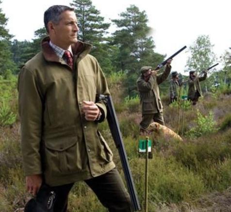
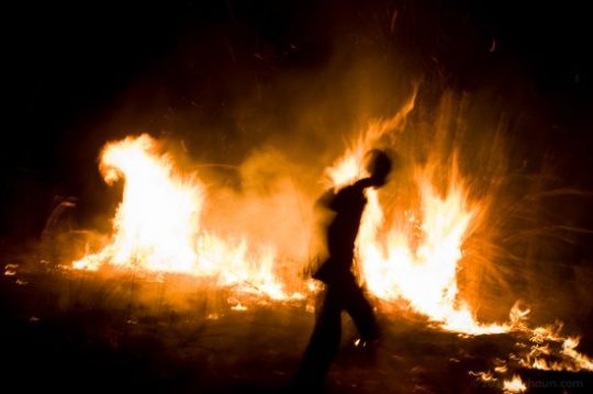

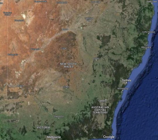
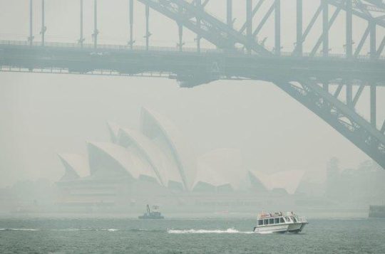

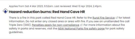

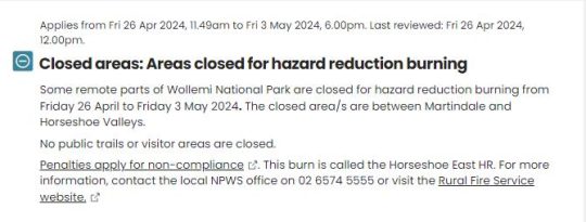
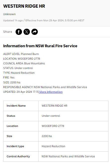


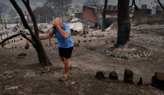

")


")

")


")


")
")


")


")
")
")

 Bush Arsonist - Brendan James Sokaluk (AAP)")


")


")


")
")

")


