Posts Tagged ‘Hawkesbury Road Winmalee Fire’

Blue Mountains hazard reduction same as arson

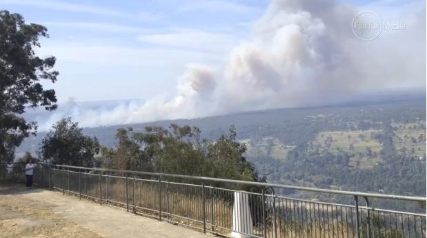
Monday, September 30th, 2013
Hawkesbury Heights Hazard Reduction 2013
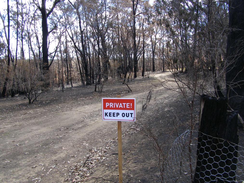
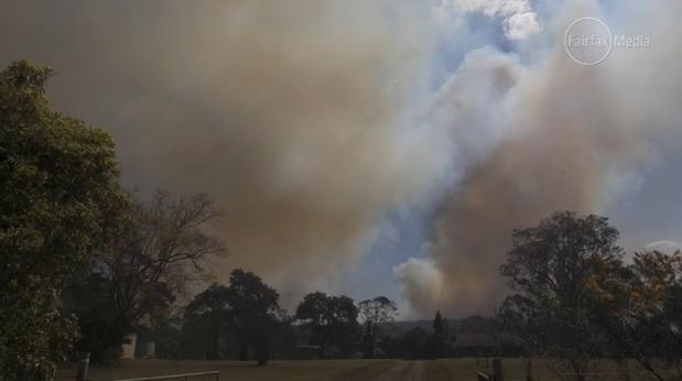
Hawkesbury Heights hazard reduction negligence
Well our fire “escaped”.  Sorry, we’re immune from prosecution.
[Photo by our Investigator along Hawkesbury Road, Blue Mountains, Australia, 20130921, photo © under  ^Creative Commons]
 

.

Partners in crime:  big ego Blue Mountains National Parks with even bigger ego Blue Mountains RFS, have jointly stuffed up big this time.

.

Hawkesbury Heights HR turned Wildfire
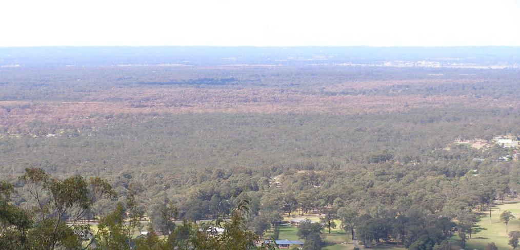
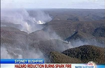
A hazard reduction north of the Hawkesbury Road from the previous weekend was left abandoned. 
A few days later the forecast wind picked up and voila:   HR come wildfire. Woops.
Sound familiar?   Warrumbungles (2013), Macleay River (2012), Grose Valley (2006), Canberra Firestorm (2003)
[Source:  Fairfax, ^http://www.smh.com.au/nsw/hazard-reduction-burn-started-major-sydney-bushfire-20130913-2tois.html]

.

Hawkesbury Heights residents will recall last year’s escaped hazard reduction along the Springwood Ridge inside the Blue Mountains National Park.  It was left for few days, then the forecast prevailing sou’wester picked up on 30th August 2012.  The fire jumped containment lines then threatened the Bowen Mountain community to the nor’ east.

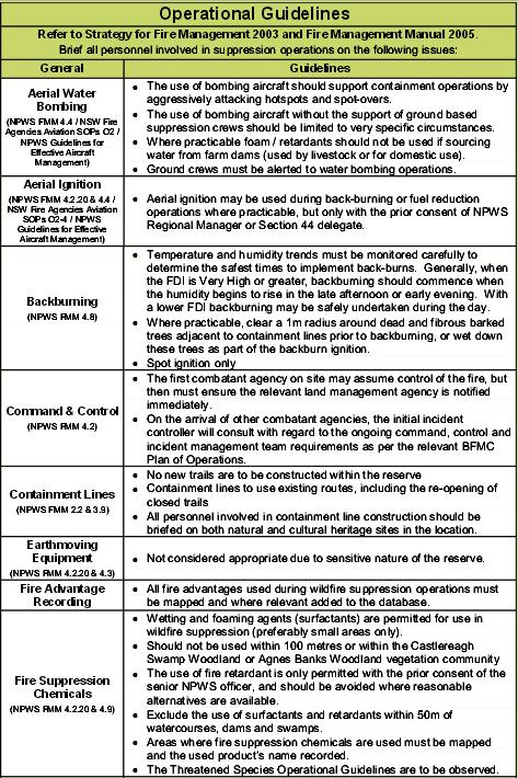
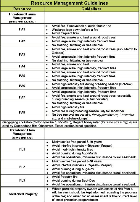
<<More than 30 firefighters from the NSW Rural Fire Service and National Parks and Wildlife Service have worked behind homes in the community of Bowen Mountain to contain this fire.  Crews backburned to establish containment lines around the fire with the assistance of helicopters and earth moving machinery.>>

Bowen Mountain Fire 20120830National Park ablaze thanks to government-sanctioned arson
[Source:  Blue Mountains RFS, ^http://www.bluemountains.rfs.nsw.gov.au/dsp_more_info_latest.cfm?CON_ID=18199,  Reference will probably disappear within days of publication.]

How much did that stuff up cost?  This is where donations to the RFS are going.

The Habitat Advocate reconstructs that the HR folly at Hawkesbury Heights two weeks ago probably unfolded as follows:

Blue Mountains National Parks decides that its a good idea to set fire to the Blue Mountains National Park along Shaws Ridge.  Shaws Ridge is over two kilometres from the Hawkesbury Road.  It has nothing to do with ‘asset protection’ to private properties.  So the Parks Service just calls it ‘strategic’ or an ‘ecological burn’ – good for the bush.

“Generally over an 8-12 year cycle it [vegetation] needs to be burnt, which allows it to regenerate.”     ~ Blue Mountains RFS district manager David Jones, 20130918.

The bush and its wildlife likes being burnt.  Parks Service’s gospel Fire Maps shows in bright red that this part of the protected Blue Mountains National Park (World Heritage Area) hasn’t been burnt for 8 years, so it must to be burned, just in case it burns!

So the fire cult’s mindset is fixated.  Parks Service includes the area to its annual hazard reduction burning programme and checks the weather forecast. The Bureau of Meteorology forecasts low winds but with expected changes later in the week.  She’ll be right.  The job will be over in a day.  Parks Service sees the low wind HR window and goes for it.

Parks Service musters up their fire friendly mates at the RFS down at Winmalee and Hawkesbury Heights and complicitous stations.  The HR is on!  So all the cracks had gathered to the fray.  All the tried and noted firies from the stations near and far mustered along Shaws Ridge fire trails.  For the firies love the smell of wood smoke along the fire trails and the old red Isuzu’s snuff the battle with delight.

Prescribed Burning
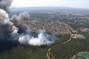
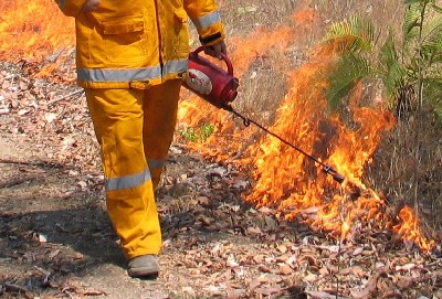
Hazard Reduction: Reducing the World Heritage Hazard
‘Cos see when there’s a real wildfire, Dad’s Army can’t cut the mustard

.

The hazard reduction proceeds on the Sunday 8th September with hardly a breeze in hilly timbered terrain, using trucks only along ‘fire’ trails.  We won’t need choppers.  They’ll only blow the budget.   Sunday night falls, job done and the vols go home.  Monday a bit windy, then Tuesday really warm and the wind picks up, gusty to blazes.

The media reports as follows:

<<A hazard-reduction burn that got out of control sparked one of four major bushfires that ravaged western Sydney and the Blue Mountains this week, fire authorities have revealed.

NSW Rural Fire Service Deputy Commissioner Rob Rogers said the National Parks and Wildlife Service had been conducting a hazard-reduction burn near Hawkesbury Road in Winmalee last weekend, which flared up in Tuesday’s soaring temperatures and high winds.   [Ed:  Winmalee?  Close, but try Hawkesbury Heights further north.]

Rob Rogers:

“Basically it was burnt on the weekend, it was patrolled on Monday, there was smouldering activity. That fire then jumped containment lines [on Tuesday].”

.

Rural Fire Starters
.

National Park HR escapes again
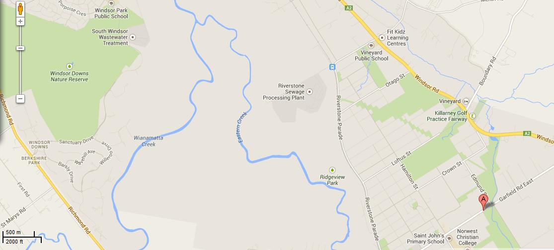
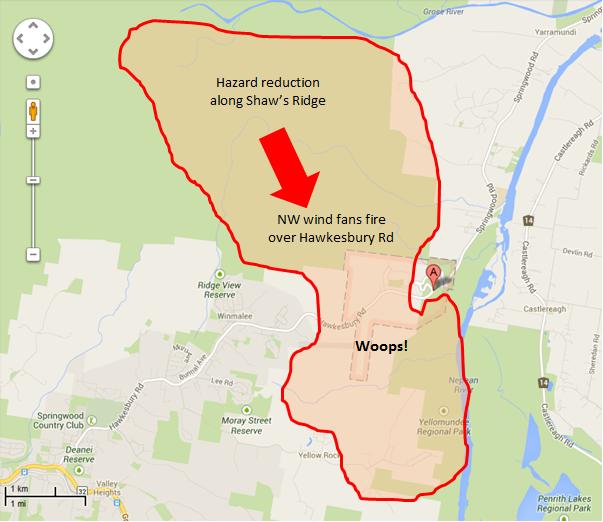
The Parks Service and RFS secretively keep fire operational matters behind closed doors for fear of embarrassment and of being sued.
So our research investigator conducted a post-fire inspection on Saturday 20130921 and has estimated the above impact and scenario. 
Perhaps those in charge can prove us wrong? We invited them to.
[Source:  The Habitat Advocate, assisted with Google Maps]

.

<<Just 10 minutes earlier the family had been told by firefighters to remain calm before a freak wind change sent the blaze roaring uphill towards their house.  “Evacuate” was the order.>>

[Source:   ‘I put my foot down and drove through the fire’: Mother tells how she fled with children in Winmalee’,  20130911, by Taylor Auerbach, The Daily Telegraph, ^http://www.dailytelegraph.com.au/news/nsw/i-put-my-foot-down-and-drove-through-the-fire8217-mother-tells-how-she-fled-with-children-in-winmalee/story-fni0cx12-1226716604185]

.

Hawkesbury Heights Hazard Reduction out of control
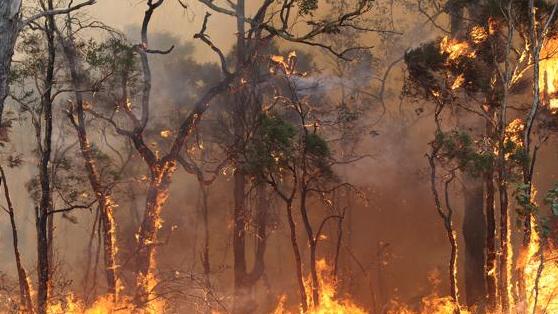
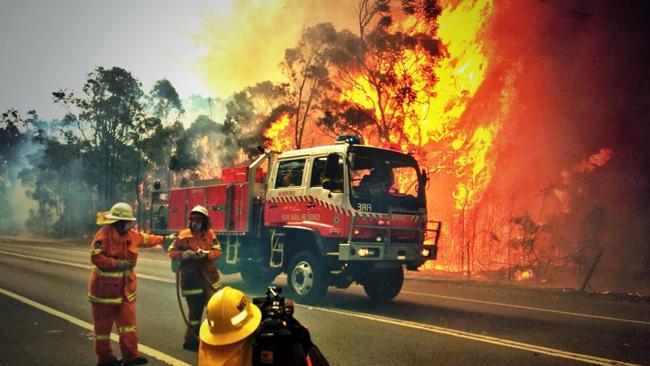
Tackling the Winmalee Hazard Reduction come Wildfire on Hawkesbury Road. 
Heroes extinguishing the neglect of their Parks Service cousins.
 

.

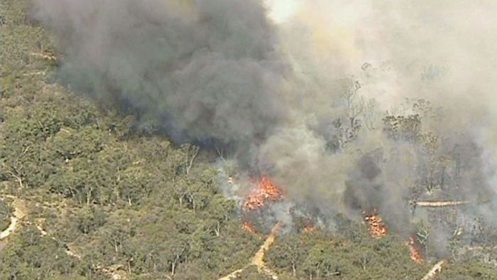
<<A fire burning in the area of Hawkesbury Road at Winmalee has already claimed one property, with more than 100 firefighters working to contain the blaze.  Five firefighters have suffered from smoke inhalation and two received minor burns battling the fire in Winmalee.>>

[Source:  ‘Bushfire burns Winmalee home, others at risk in Blue Mountains’, 20130910, Sydney Morning Herald, Photo by Nick Moir, ^http://www.smh.com.au/nsw/bushfire-burns-winmalee-home-others-at-risk-in-blue-mountains-20130910-2ths1.html]

.

<< Firefighters have contained a blaze that has burnt through more than 1000 hectares of bushland west of Sydney.  The fire, at Winmalee in the Blue Mountains, has been burning since Tuesday fanned by high temperatures and strong winds, plunging the region into emergency.  Firefighters were still water bombing the burning bushland on Thursday.

The Rural Fire Service on Friday said the fire had been contained.

RFS spokeswoman Laura Ryan:

“It was brought fully under control last night just before a community meeting at Winmalee High School.  Firefighters (unpaid) would today work to extinguish the blaze, but said it was too early to say how long that would take. Firefighters will be working hard to get every bit of that fire out.”

The RFS and NSW Police say they have launched investigations into the cause of the bushfire, with some locals raising concerns that recent hazard reduction burns in the area may be responsible.     [Ed:  NSW Police need not investigate far beyond the operational records of the Blue Mountains National Parks and Wildlife Service, with internal documents circulated to the RFS]

.

Winmalee and Yellow Rock residents at the local high school
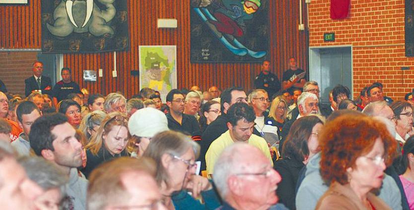
More than 350 Blue Mountains residents pack the Winmalee High School on Thursday night 12th September, fearful whether they could lose their homes to Hazard Reduction.
[Source:  ^http://news.ninemsn.com.au/national/2013/09/13/07/00/winmalee-bushfire-contained-rfs]

.

<< A Rural Fire Service organised community meeting held last week at Winmalee to discuss the fire situation in Winmalee and Yellow Rock was well attended.

Winmalee and Yellow Rock residents aired their bushfire concerns at a community meeting organised by the NSW Rural Fire Service (RFS) at Winmalee High School last Thursday night.

Despite the meeting only being publicised that day, the school hall was nearly full with 350 residents.  At least 10 people in the room did not receive an RFS emergency safety warning text message to take shelter.

Blue Mountains RFS district manager David Jones said he would, “feed that back up the line … it may be a service provider issue, I’m not sure, that may be part of it” and that he would look further into the issue.

A Yellow Rock resident asked what hazard reduction burns would take place in Yellow Rock in the near future.

Supt Jones said the weather conditions last week hadn’t been suitable to maintain control of a backburn.

“It’s a one-way, one-road in and its never received the recognition it deserves on that basis in terms of protection,” the Yellow Rock resident said.  “I would hate to see a real emergency situation develop here at Yellow Rock.”

Supt Jones said he’d look at the RFS organising a meeting with Yellow Rock residents in the near future to address these issues.  Supt Jones said residents could have a fire mitigation officer assess if hazard reduction was needed in their area by lodging a hazard complaint with the RFS.

“Generally over an 8-12 year cycle it [vegetation] needs to be burnt, which allows it to regenerate,” he said.

National Parks and Wildlife Service (NPWS) Upper Mountains area manager Richard Kingswood said there weren’t many days a year suitable for conducting hazard reduction burns — only 10 days in the Upper Mountains and a few more in the Lower Mountains, although last autumn and spring had provided more opportunities. He said in the last financial year NPWS had initiated 38 burning operations over 50,000 hectares, which was more than usually occurred.

Another resident asked why, with safety concerns with overhead powerlines, they couldn’t go underground, especially as the highway was being widened.  An Endeavour Energy spokesman said cost was an issue.  “It costs about 10 times more to put mains underground.”

Others were concerned about issues around road blocks, where children as well as adults were allowed to walk past roadblocks to return home, yet people couldn’t get their vehicles through. It didn’t make sense from a safety perspective, the resident said.>>

[Source:  ‘Concerns aired at Winmalee fire meeting’, 20130918, by Ilsa Cunningham, Blue Mountains Gazette, ^http://www.bluemountainsgazette.com.au/story/1782194/concerns-aired-at-winmalee-fire-meeting/]

.

Hawkesbury Heights Hazard Reduction
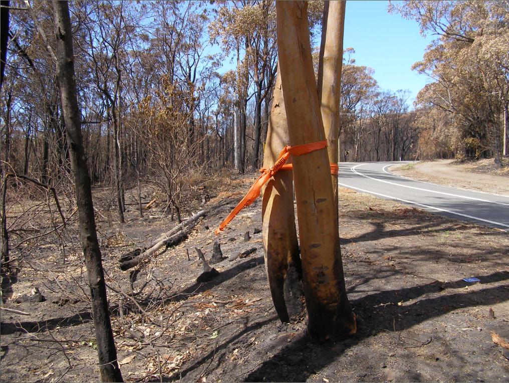
Hawkesbury Road well and truly hazard reduced
[Photo by our Investigator along Hawkesbury Road, Blue Mountains, Australia, 20130921, photo © under  ^Creative Commons]

.

<< More than 1200 firefighters were involved in battling the four major fires on Tuesday along Hawkesbury Road in Winmalee; in Marsden Park in the Blacktown area; near Tickner Road in Castlereagh; and Richmond Road at Windsor.   Fourteen helicopters and 350 trucks from the Rural Fire Service, Fire and Rescue NSW and the National Parks and Wildlife Service were involved in the firefight.

Just before 1.30pm on Tuesday, the temperature in Sydney was 31.6 degrees.   Mr Rogers said strong wind also made fire conditions worse, with gusts reaching 90 kilometres an hour, which was much higher than forecast.

He said RFS firefighters helped in the hazard-reduction operation in Winmalee, which was under the supervision of the NPWS, and he apologised to anyone who experienced property damage.

“Combined with the winds, how dry it is, the temperature and the steep terrain, fire takes hold very, very quickly.”

He said the RFS also was investigating whether a hazard-reduction burn escaped and forced the closure of the M1 (formerly the F3) Motorway on Thursday.

“You would have to obviously be suspicious that it did come from a hazard-reduction, given that it was in a very close proximity to it. That’s something that we’re going to be looking at very, very closely,” he said.>>

<<Fire authorities have issued an emergency warning for a bushfire threatening homes in Castlereagh in Sydney’s west, and alerts for other out of control bushfires in Blacktown and Hawkesbury.

NSW Rural Fire Service Deputy Commissioner Rob Rogers said National Parks and Wildlife Service had been conducting a hazard reduction burn near Hawkesbury Road in Winmalee last weekend. The fire flared with Tuesday’s soaring temperatures and high winds.

..He apologised to anyone who experienced property damage from the Winmalee fire.   ”..It appears on first look that it’s a case of the weather was worse than was predicted, the fire jumped out, it took hold really..quickly.”  >>

Even though the fire ripped through Hawkesbury Heights, the National Parks and Wildlife Services has released a public notice asking any Winmalee residents who experienced property damage or loss have been urged to contact NPWS on 1300 361 967 for sympathy and counselling.

New South Wales Rural Fire Service (paid) Deputy Commissioner Rob Rogers has said that his (unpaid) RFS firefighters helped in the hazard-reduction operation in Winmalee, which was under the supervision of the NPWS, and he apologised to anyone who experienced property damage.

.

Hawkesbury Heights property damaged by bushfireRFS:  Sorry about that
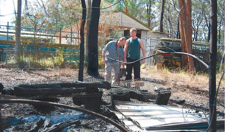
Property loss at Hawkesbury Heights (Wheatley Road?) but who pays?
Owner:   “we won’t need hazard reduction for a while.”
[Source:  ‘Bushfire wake-up call’, 20130918, by Shane Desiatnik,
^http://www.theleader.com.au/story/1782048/bushfire-wake-up-call/]

.

[Sources:  ‘Hazard reduction burn started major Sydney bushfire’,  by Megan Levy, 20130913, ^http://www.smh.com.au/nsw/hazard-reduction-burn-started-major-sydney-bushfire-20130913-2tois.html; and ‘Burn-offs and arson suspected as cause of two bushfires’, by Megan Levy and Peter Hannam, 20130914, ^http://www.smh.com.au/nsw/burnoffs-and-arson-suspected-as-cause-of-two-bushfires-20130913-2tq15.html]

.

National Parks and Wildlife Advisory Council Report

(42nd meeting held on 28-29 May 2013)

.

<< Council noted the following details regarding the current status of fire management activity by NPWS:

  • The 135 000ha annual target has been met with a total of 176 000ha now treated.
  • Almost 3 times more area treated than the average for last five years.
  • 6-7000ha hazard reduction activity planned over the next week.
  • Opportunity to increase positive community profile for NPWS.
  • Statewide strategy with performance indicators in place at state and regional levels. >>

.

[Source:  New South Wales Government, NSW National Parks and Wildlife Service, ^http://www.environment.nsw.gov.au/resources/about/NPWAdvisoryCouncMay2013.pdf]

.

National Parks and Wildlife ServiceIn Parks we Trust

.

In New South Wales the National Parks and Wildlife Act became law on 1 October 1967.  The legislation created a single agency, the National Parks and Wildlife Service, to care for, control and manage the original nineteen parks and any new ones created in the future.

.

.


.

Further Reading:

.

[1]    ‘NPWS Fire Fighters Recognised for Service as NSW Gets 10 Year Fire Plan‘, 20130422, NSW Government, ^http://www.environment.nsw.gov.au/resources/MinMedia/MinMedia13042201.pdf

>Download Document  (PDF, 2 pages, 36kb)

.

[2]    ‘National Parks and Wildlife Advisory Council Report‘, 42nd meeting held 20130528-29, NSW Government, ^http://www.environment.nsw.gov.au/resources/about/NPWAdvisoryCouncMay2013.pdf

>Download Document  (PDF, 1 page, 29 kb)

.

[3]   ‘Fire Management Manual, 2012-2013‘, NSW National Parks and Wildlife Service, NSW Government, ^http://www.environment.nsw.gov.au/resources/firemanagement/final/OEH20120645FireMgmtManual.pdf

>Download Document  (PDF, 223 pages, 1.0 MB)

.

[4]   ‘Blue Mountains National Park Plan of Management‘,  May 2001, NSW National Parks and Wildlife Service, ^http://www.environment.nsw.gov.au/resources/parks/pomfinalbluemountains.pdf

>Download Document  (PDF, 108 pages, 750 kb)

.

[5]   ‘Greater Blue Mountains World Heritage Area – Strategic Plan‘, January 2009,  Department of Environment and Climate Change (NSW) with funds supplied by the Australian Government, ^http://www.environment.nsw.gov.au/resources/parks/StategicPlanNPWS.pdf

>Download Document  (PDF, 58 pages, 5.4 MB)

.

[6]   ‘National parks and forest conservation‘, 2006, by Brett J. Stubbs, School of Environmental Science and Management, Southern Cross University, Lismore, New South Wales ^http://fennerschool-associated.anu.edu.au/environhist/links/publications/anzfh/anzfh1stubbs.pdf

>Download Document  (PDF, 8 pages, 150 kb)

.

Cumberland Plains Woodland disappearing

Tuesday, September 10th, 2013
Windsor Nature Reserve on fireWindsor Downs Nature Reserve ablaze
Mis-identified by media as the ‘Marsden Park Fire’ ..”which started burning in a tip..”
[Source: Two Homes under threat in Sydney grass fire‘, 20130910, Australian Broadcasting Corporation,
^http://www.abc.net.au/news/2013-09-10/two-homes-under-threat-in-sydney-grass-fire/4948314]

.

Why did three wildfires start today in north western Sydney in protected reserves of Sydney’s remnant Cumberland Plains Woodland?

The fires all started around midday during high gusty wind conditions and unseasonally high temperatures.  There was no lightning to speak of, so all three fires must have been caused by people.

Reckless burnoffs? Deliberately lit?   By the same people?  By developers wanting to undermine the Cumberland Plain Woodland and so extend their sprawl?

Whether it was bush arson or recklessness will be a matter for bushfire investigations which need to be mandatory for each and every wildfire.  A forth wildfire at Winmalee in the nearby Blue Mountains (the ‘Hawkesbury Road Winmalee Fire‘) was purportedly a neglected hazard reduction burn – the Rural Fire Starters fuelling more work for themselves.

What did each wildfire cost – economic loss, infrastructure loss, productivity loss, direct firefighting costs, indirect costs, social costs?  These are never measured or reported.  The ecological costs are always ignored because ecology is not deemed to be valuable in our current society.  How much death and harm has been infliced upon Windsor Downs Nature Reserve?  Such value questions are beyond the thinking of our current society.

The RFS only prioritises saving human life and property.  It thus has no different role than the NSW Fire Brigade.  So the RFS should not exist.  It only exists because the New South Wales government does not want to properly pay for firefighting.  The RFS exists as unpaid volunteers so that the NSW government can divert hundreds of millions in taxes to other priorities it somehow considers to be more important.

Then the NSW government appeals for more volunteers to do its dirty work for free.

RFS Open Day 2013Rural Fire Starters.

Whereas in New South Wales, a NSW Fire Brigage professional firefighter gets paid $29 an hour minimum.  There will be many families that would dearly desire to receive that for their unpaid volunteering efforts.

>Benefits of being a Retained Firefighter   (NSW Fire & Rescue)

.

“At Richmond Road and Bennett Road at Windsor, the RFS  (New South Wales Rural Fire Service) says a grassfire could impact properties around George Street and the area of Bligh Park.  The fire has crossed Garfield Road and is burning in the Windsor Downs Nature Reserve.”

[Sources:  ‘Home lost as grass fires rage in Marsden Park and Windsor‘, 20130910, Daily Telegraph newspaper, Sydney, ^http://www.dailytelegraph.com.au/newslocal/the-hills/home-lost-as-grass-fires-rage-in-marsden-park-and-windsor/story-fngr8i1f-1226716140957;  ‘Two Homes under threat in Sydney grass fire‘, 20130910, Australian Broadcasting Corporation, ^http://www.abc.net.au/news/2013-09-10/two-homes-under-threat-in-sydney-grass-fire/4948314]

.

The fire authorities have labelled this current fire the ‘Richmond Road Grass Fire‘, so will the records of the fire will be just scattered or erased?   Today’s initial account of the fire on the official Rural Fire Service website reads thus :

“..A grass fire burning in the area of Richmond Road and Bennett Road at Windsor”.  The fire is burning on both sides of George Street, South Windsor and both sides of Richmond Road. The fire is burning under strong northerly winds. An Emergency Alert telephone message has been sent to residents in these areas.

There is the potential for the fire to impact on properties around George Street and the area of Bligh Park.  The fire has crossed Richmond Road and is now burning in the Windsor Downs Nature Reserve.”

.

To put this into geographic perspective, this is a presumed map of the affected area, in absence of RFS public transparency:


Windsor Downs Fire Ignition Map

The presumed ignition of the Richmond Road Grass Fire
from Bennett Road, Windsor Downs
(outer north-western Sydney Metropolis)
[Source:  Google Maps 2013]

.

<<Emergency warnings have now been issued for four bushfires in Sydney’s far north west, as temperatures in the city exceed 30 degrees with strong northerly winds.

The RFS says five firefighters have sustained smoke inhalation and two have received minor burns.

The fires are at Castlereagh, Richmond, Marsden Park, and Winmalee where one property is alight.  At Richmond Road and Bennett Road at Windsor, RFS says a grassfire could impact properties around George Street and the area of Bligh Park.  The fire has crossed Garfield Road and is burning in the Windsor Downs Nature Reserve. >>

.

[Ed:  Garfield Road is in Riverstone, not Richmond, and is also quite distinct from the separate fire at Windsor Downs.  Media reporting has been misleadingly false, overlapping and confused and likely due to naive junior desktop journalism.  Worse is that the RFS report is equally confused.  Fortunately no person died relying upon officialdom, but the wildlife count is never published].

.

.
Garfield Road Fire
Map showing the juxtaposition of the Windsor Downs Nature Reserve over 3 km north west from Garfield Road in Riverstone.
Journalists have a lot to answer for when it comes to fact checking during emergencies.

[Source:  Google Maps 2013, click image to enlarge]

.

<< About 3,200 homes in the Richmond area have lost power and Endeavour Energy says it is working to get the supply back.  The RFS says the fire is burning intensely under strong winds.

In Marsden Park,  a grass fire is burning out of control and has crossed Garfield Road.  While at Castlereagh, near Penrith, an emergency warning was issued around noon (AEST) for a fire which has destroyed a shed and burned 60 hectares.  About 50 homes are thought to be under threat.  The fire is burning around properties on Devlin Road and is moving towards homes on Nutt Road.

RFS Inspector Ben Shepherd says the conditions are difficult for firefighters.

RFS Inspector Ben Shepherd:

“I’m currently sitting on Nutt Road and the fire is moving quickly towards some homes in that area. The actual fire itself is putting up a huge column of smoke… and the wind continues to be quite strong.  Because of that, that’s starting to send a couple of spot fires ahead of the main fire front itself.”

.

Local resident Kelly Elson has been evacuated from her home near the fire front.  She says she first noticed the fire at about 10:30 this morning.

Windsor resident Troy Evans says that fire started in grass near his house on Bennett Road.

Windsor resident Troy Evans:

“So I went and told the firies ‘you better get a couple of trucks round here real quick’  which they did, luckily.  They got the place under control then the wind turned and it’s just roared up through next door, jumped the road, it’s gone through the church, it’s over in the bus bay, it’s meant to have taken a couple of houses out in Bligh Park.  Now it’s on it’s way into the jail, it’s just crazy.”

.

A very high fire danger alert has been issued for the Illawarra, Sydney, the Central Ranges, the Hunter, the north west and the north coast.  More than 40 uncontained bushfires are currently burning across New South Wales.

Mr (RFS Commissioner Shane) Fitzsimmons says it is hot, dry and windy in most of the state today, with seven districts in very high fire danger.  He says he is worried about the unseasonally warm start to spring on the back of a dry winter.

The RFS is urging property owners in semi-rural and rural areas to think about the conditions before they burn off land.”

.

[Ed:   Fitzsimmons, why blame the weather and not the landholder who is accused of causing the ignition?]

.

[Source:  ‘Homes under threat from bushfires at Castlereagh and Windsor in Sydney’s far north west’, 20130910, Australian Broadcasting Corporation, ^http://www.abc.net.au/news/2013-09-10/two-homes-under-threat-in-sydney-grass-fire/4948314]

.

[Ed:  So the RFS is urging property owners in semi-rural and rural areas to think about the conditions before they burn off land. 

Is this head office code for the known landholder who caused the fire and the RFS being too public servant skin timid to lay charges?  So why is the landholder in Bennett Road not under arrest for suspected arson?]

.

Windsor Nature Reserve

The fire inside the Windsor Downs Nature Reserve today

.


Windsor Downs Nature ReserveWindsor Downs native woodland habitat being burned alive
[Source:  ‘Bushfires threaten Sydney’s western suburbs – NSW Rural Fire Service issues emergency warnings’, 20130910, Sydney Morning Herald newspaper (Sydney), ^http://www.smh.com.au/environment/bushfires-threaten-sydneys-western-suburbs-nsw-rural-fire-service-issues-emergency-warnings-20130910-2thnl.html]


.


.

National Parks and Wildlife ServiceA liar bird of disinterested political masters

.

.

Cumberland Plain Woodland

.

Cumberland Plain Woodland including the Windsor Downs Nature Reserve, the nearby Castlereagh Nature Reserve and Agnes Banks Nature Reserve, all fall under the custodial management responsibility of the National Parks and Wildlife Service New South Wales – a state body.

Windsor Downs Nature Reserve features.. << an historic windmill and water tank protects a number of endangered plant communities and includes species such as the broad-leafed ironbark, grey box, scribbly gum, narrow-leafed angophora, pea flowers and a species of geebung.  

Several bird species have been recorded – the red-capped and hooded robins, white-winged choughs, buff-rumped and yellow-tailed thornbills and the endangered regent honeyeater – which are usually found in the drier habitats of the central west slopes. >>

[Source:  NSW Government, ^http://www.environment.nsw.gov.au/NationalParks/parkHome.aspx?id=N0598]

.

Windsor Downs Nature Reserve is not just set aside for picnics.  It is a remant ecological community with the fast disappearing Cumberland Plain Woodland.  It is supposed to be protected.

.

<< The Cumberland Plain Woodland is the name for the distinct groupings of plants that occur on the clay soils derived from shale on the undulating Cumberland Plain in central New South Wales. The most commonly found trees in the woodland are Grey Box Eucalypts Eucalyptus moluccana, Forest Red Gums Eucalyptus tereticornis, Narrow-Leaved Ironbarks Eucalyptus crebra and Spotted Gum Eucalyptus maculata. A variety of other lesser-known eucalypts as well as shrubs, grasses and herbs are also found. It is the dominance of Grey Box and Forest Red Gum that makes the community distinctive.

In 1877 Cumberland Plain Woodland covered 107,000 hectares occupying approximately 30 per cent of the Sydney Basin. This community type was once widespread in the Plains but has been reduced to a few fragmented stands by human use for farming, industry and housing. Today less than six per cent remains in small fragments scattered across the western suburbs of Sydney, totalling only 6400 hectares. The remaining fragments occur in areas subject to intense pressure from urban development.

Although some areas occur within conservation reserves, this is in itself not sufficient to ensure the long-term survival of the community unless the factors threatening the integrity and survival of the community are eliminated.

The remaining stands of this ecological community are threatened by the spread of the Sydney suburban areas. Threats include clearance for agriculture, grazing, hobby and poultry farming, housing and other developments, invasion by exotic plants and increased nutrient loads due to fertiliser run-off from gardens and farmland, dumped refuse or sewer discharge.>>

[Ed: and of course ‘bushfire’, which the government does not like to include out of embarassment of neglect, yet which is causes the most devastating impact].

.

[Source:  ‘Woodlands vanishing from Sydney’s outskirts’, by Environment Australia, Australian Government, ^http://www.environment.gov.au/biodiversity/threatened/publications/cumberland.html]

.

Cumberland Plain Woodland in the Sydney Basin Bioregion – proposed critically endangered ecological community listing

.

<< The NSW Scientific Committee, established by the Threatened Species Conservation Act, has made a Preliminary Determination to support a proposal to list the Cumberland Plain Woodland in the Sydney Basin Bioregion as a CRITICALLY ENDANGERED ECOLOGICAL COMMUNITY on Part 2 of Schedule 1A of the Act and as a consequence, to omit reference to Cumberland Plain Woodland from Part 3 of Schedule 1 (Endangered Ecological Communities) of the Act. The listing of Critically Endangered Ecological Communities is provided for by Part 2 of the Act.

The Scientific Committee has found that:

1. Cumberland Plain Woodland was listed as an Endangered Ecological Community under the Threatened Species Conservation Act 1995 in June 1997 (NSW Scientific Committee 1997). Since this listing, a large volume of new data and analyses have become available. In addition, a nomination to change the status of Cumberland Woodland to Critically Endangered status has been received. This Determination addresses additional information now available in accordance with current listing criteria under the Threatened Species Conservation Regulation 2002.

2. Cumberland Plain Woodland is the name given to the ecological community in the Sydney Basin bioregion associated with clay soils derived from Wianamatta Group geology, or more rarely alluvial substrates, on the Cumberland Plain, a rainshadow area to the west of Sydney’s Central Business District.  >>

<<..high frequencies of fires may result where fragmentation increases the interface between urban areas and bushland, as this results in increased arson, car dumping, planned fuel-reduction fires and accidental ignitions.

High fire frequencies are associated with reduced diversity of native plant species in Cumberland Plain Woodland (Watson 2005). ‘High frequency fire resulting in disruption of life cycle processes in plants and animals and loss of vegetation structure and composition’ is listed as a Key Threatening Process under the Threatened Species Conservation Act 1995.

The season of fire, which may be altered as a consequence of hazard reduction fires, may also influence the species composition of the grassy woodland understorey (Knox & Clarke 2006; Benson & von Richter 2008).

Disruption of ecological processes associated with alteration of fire regimes contributes to a very large reduction in ecological function of the community. >>

.
[Source:  ‘NSW Scientific Committee – preliminary determination’, Australian Government, ^http://www.environment.nsw.gov.au/determinations/cumberlandplainpd.htm]

.

But wait, there is a:

^Windsor Downs Nature Reserve Fire Management Strategy

which reads…

.

The official Fire Management Strategy has been conveniently removed from public access on the National Parks and Wildlife Service (NPWS) website.

However, the following extracts from the similar and nearby Agnes Banks Nature Reserve are instructive as to the approach taken by NPWS management on all nature reserves across the Sydney Basin that comprise remnant ecology of the Cumberland Plain Woodland.

.

Fire Management Operational Guidlines (NPWS,2006)

.

Fire Management Resource Management Guidlines (NPWS,2006)

Source:  ‘Agnes Banks Nature Reserve Fire Management Strategy, 2006, (last modified 20070323), NPWS (NSW), NSW Government, ^http://www.environment.nsw.gov.au/resources/parks/06354AgnesBanksFMS.pdf]

.

[Ed:  Disturbingly noted is that the NPWS ‘ecological’ policy is that it ok to burn these woodland reserves every 8 years. So government care factor about bushfire impact?]

.

<<..little research has been undertaken into fire management prescriptions for Cumberland Plain woodland and forest associations when compared to the nearby Hawkesbury sandstone communities.>>

~ Windsor Downs Nature Reserve et al. Plan of Management (NPWS 1999,p.18)

.

The official Bureau of Meteorology had in the days prior, forecast strong gusty north westerly winds for the western Sydney region for both yesterday and today, following a few days of calm winds.  The Rural Fire Service would have been well aware of this forecast, the extreme bushfire conditions that this posed and the considerable escalated risk of damaging wildlfires.

The subsequent actual weather observations for Richmond are telling.  Look at the 10th.  The arsonists know what they are doing.

.

Weather Observations at Richmond[Source:  Australian Bureau of Meteorology,
^http://www.bom.gov.au/climate/dwo/201309/html/IDCJDW2119.201309.shtml]

.

Reliant mainly on public calls to ‘000’, fire trucks and road-routed volunteers, the RFS continues to be grossly under-equipped to handle wildlfires in a timely and effective manner, which increasingly to many is unacceptable to bushfire prone communities in this now 21st Century.

.

Windsor Downs Nature Reserve ablazeWindsor Downs Nature Reserve ablaze  (from Hawkesbury Lookout)
[Source:  ‘Hazard reduction burn started major Sydney bushfire’, by Megan Levy, Sydney Morning Herald, 20130913,
^http://www.smh.com.au/nsw/hazard-reduction-burn-started-major-sydney-bushfire-20130913-2tois.html]

.

Windsor Downs Nature Reserve incineratedWindsor Downs Nature Reserve incinerated (see browned woodland canopy in centre of photograph)
[Photo taken by Editor from Hawkesbury Lookout looking north east on 20130921, photo © under  ^Creative Commons]
Click image to enlarge

.

Steadily year on year, the last bushland reserves that provide critical remnant habitat around Sydney are being destroyed.   Before long the only bushland will be that in suburban gardens, and the wildlife will be finally made regionally extinct.

.

Regent Honey EaterCritically Endangered Regent Honeyeater
(Anthochaera phrygia)
A native bird species dependant upon a disappearing habitat
Humans obliterated its habitat for logging, farming and housing
Then we constrained it to a few nature reserves like Windsor Downs,
Then we burnt the reserve.

.


.


.

Further Reading:

.

[1]   ‘NSW Scientific Committee – preliminary determination‘, Australian Government, ^http://www.environment.nsw.gov.au/determinations/cumberlandplainpd.htm

>Download Report  (125kb, 18 pages, PDF)

.

[2]   Castlereagh, Agnes Banks and Windsor Downs Nature Reserves – Plan of Management‘, NSW Government, ^http://www.environment.nsw.gov.au/resources/parks/pomfinalagnescastlereagh.pdf

>Download Report  (100kb,38 pages, PDF)

.

Footnote

.

‘Hunt for arsonist over western Sydney bushfire’

[Source:  ‘Hunt for arsonist over western Sydney bushfire’, Friday 20130913, ABC, ^http://www.abc.net.au/news/2013-09-13/hunt-for-arsonist-over-western-sydney-bushfire/4956022]

.

<<Authorities say they believe a fire that destroyed a home at Marsden Park in Sydney’s west on Tuesday was deliberately lit.   Investigators have also not ruled out that an arsonist may have caused a blaze at nearby Londonderry.   Police are now calling for witnesses to help identify the person responsible for sparking the Marsden Park fire.

Assistant Commissioner Alan Clarke says it is believed the fire began on Grange Avenue just after midday on Tuesday.

.

Alan Clarke:

.
“There are crime scene indicators at the source of that fire that would lead us to suspect arson activity.   I really can’t tell you more than that at the moment. It’s mainly our crime scene indicators and forensic evidence that would have us raise that suspicion.  If anyone has information, if anyone saw any suspicious activity in or around that fire location, any part of it… please pass that information on for the benefit of police.”

.

Rural Fire Service Deputy Commissioner Rob Rogers has confirmed another serious fire at Winmalee, in the lower Blue Mountains, was caused by a hazard reduction burn conducted by the NSW National Parks and Wildlife Service.

.

Rob Rogers:

“That fire was burn on the weekend, it was patrolled on Monday, there was smouldering activity.  That fire then jumped containment lines on the Tuesday and became an active fire. The winds on that day did exceed forecast and they were around 90 kilometres an hour, and obviously that tested the control lines on that hazard reduction and it did escape. In these strong winds branches came off trees, hit the powerlines, the powerlines were brought down, they ignited grass in that area and that was the cause of that fire.  You would have to obviously be suspicious that it did come from the hazard reduction, given that it was in a very close proximity to it.”

.

Investigators have found a fourth fire that began on Richmond Road at Windsor Downs was sparked by downed power lines.   The investigation into a fire that closed the M1 motorway, formerly known as the F3, north of Sydney yesterday is continuing, with another hazard reduction burn the suspected cause.  Assistant Commissioner Alan Clarke has warned those that deliberately light fires or cause them through negligence will be caught.

.

Alan Clarke:

“Last year we arrested 87 individuals and they faced charges in respect of bushfire and fire related activity for 117 charges.  We know this year again we will be putting offenders before the court. It’s sad but it’s true.”

.

error: Content is copyright protected !!