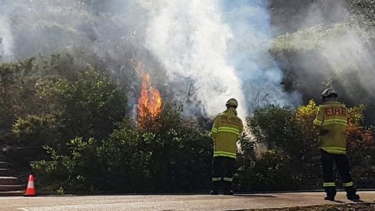
It’s Autumn in the Greater Blue Mountains, and the New South Wales Government’s bush arsonists are out in full swing deliberately setting fire to native habitat at every opportunity. Governmental ‘Habitat Reduction Season‘!
Is this pastime not comparable with the antiquated British imported tradition of the ‘Duck Season‘ – killing NATIVE ducks that is – just for sport. It’s the very same time of year!
“Capital climes for rough shooting old sport, what! Live on peg, we ought to bag a few dozen before tea.”
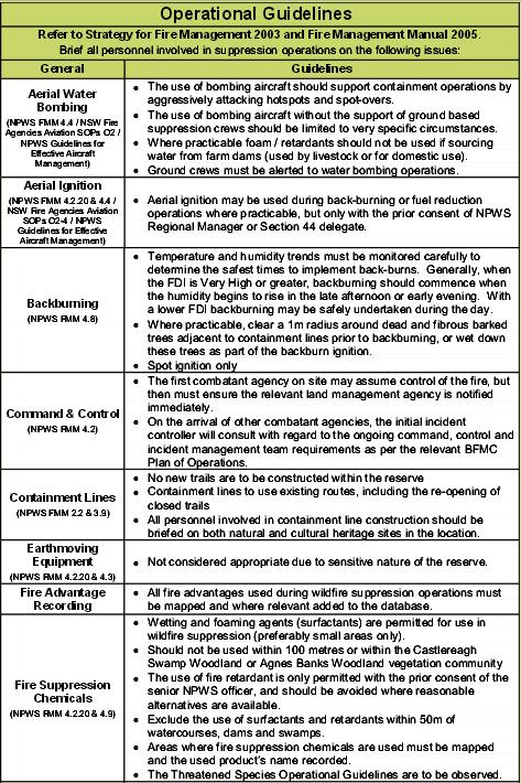
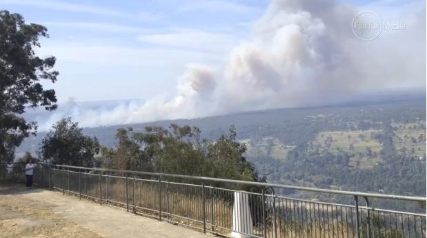
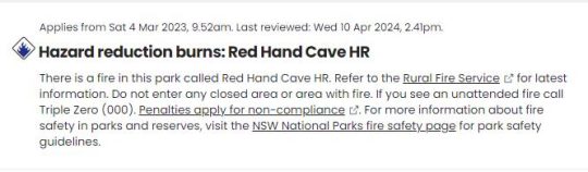
On Monday 25th March 2024, the NSW Government’s National Parks and Wildlife Service (NPWS) published a media release about its continuing “hazard” reduction burns across the Blue Mountains National Park. It read as follows (main extracts):
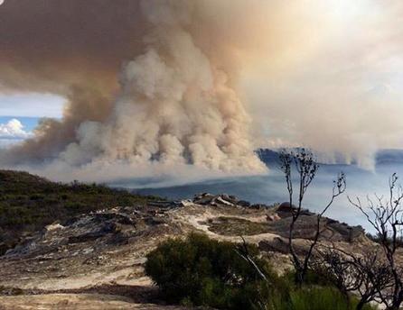
“The NSW National Parks and Wildlife Service (NPWS) has announced plans for an 850-hectare hazard reduction burn in the Glenbrook area of Blue Mountains National Park, set to commence on 26 March, weather conditions permitting. This preventive measure is part of a strategic effort to reduce the risk of wildfires and protect surrounding communities.
Scheduled to unfold over consecutive days, the operation targets the reduction of naturally accumulated fuel loads in the park. The primary aim is to provide strategic protection for the residential areas of Glenbrook, Lapstone, and Mulgoa against potential future wildfires.
…This burn is a component of the comprehensive hazard reduction program carried out by NPWS each year, often in collaboration with the Rural Fire Service and Fire and Rescue NSW. These operations are crucial for managing vegetation fuel loads and reducing the intensity and spread of potential wildfires.
The planned hazard reduction burns in Blue Mountains National Park underscore the ongoing commitment of NSW authorities to wildfire risk management and community safety. By taking proactive measures to manage fuel loads, the NPWS aims to mitigate the impact of wildfires, ensuring the protection of both natural landscapes and residential communities.”
Our comments to this bush arson justification spin doctoring:
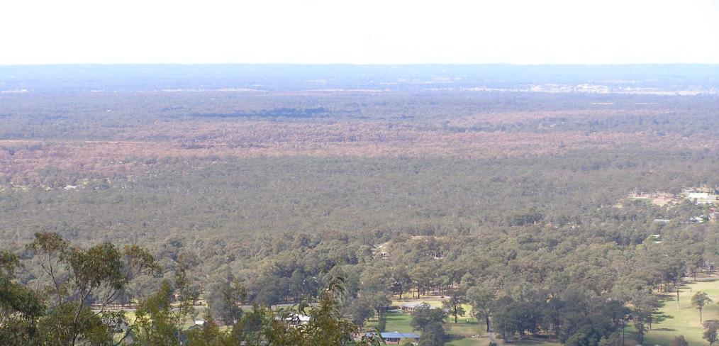
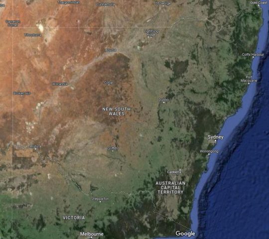
The above is bush arson propaganda by contracted consultants with Communications Degrees, justifying the perpetual decimation of Australia’s native habitat since the first day of colonisation and usurpation of the continent since 1788. Nothing has changed or is likely to. Surviving intact wilderness has become reduced to mere islands. Just go to Google Maps [See our extract map below]
“850 hectares” is an area equivalent to about 30km x 30km (√ 850ha). In relative terms, that’s three times the size of Sydney’s CBD, a native habitat area capacity for many fauna;
“preventive measure is part of a strategic effort to reduce the risk of wildfires” – this is because when wildfires do occur the NSW Government invariably fails to (A) detect, (B) respond and (C) extinguish the ignitions promptly whilst small and controllable. It has an attitude that native habitat has a lower value than human habitat. In contrast, the urban Fire and Rescue Service is tasked to (B) respond and (C) extinguish the ignitions involving human property immediately, and unlike their unpaid volunteer Rural Fire Service (RFS) counterparts, they get paid to do it;
“protect surrounding communities” – this means human communities that have been built encroaching more and more into and usurping native habitat. These human “communities” are the only focus of the NPWS and its support RFS. Under this culture, wildlife communities matter not, irrespective of any threatened species impacted/killed. This attitude belies an antiquated anthropocentric mentality. Neither the NPWS nor the RFS employ an Ecologist. They just don’t care about protecting Ecology – in this case forest ecology;
“the operation targets the reduction of naturally accumulated fuel loads in the park“. That’s right, the NPWS as delegated custodial organisation ‘manager’ of the Blue Mountains National Park treats native habitat and its dependent fauna within such national parks in NSW (one of some 800) instead as “fuel loads” to be reduced to sterile urban park status. NPWS should be relegated to managing urban parks like Hyde Park in Sydney’s CBD;
“The primary aim is to provide strategic protection for the residential areas of Glenbrook, Lapstone, and Mulgoa against potential future wildfires.” – this is a reinforcement approach of our Point 3;
“…This burn is a component of the comprehensive hazard reduction program carried out by NPWS each year, often in collaboration with the Rural Fire Service and Fire and Rescue NSW.” – this is a reinforcement approach of our Point 3;
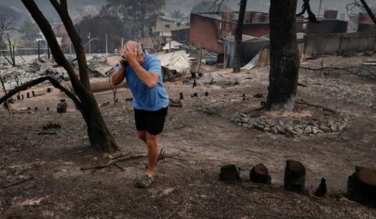
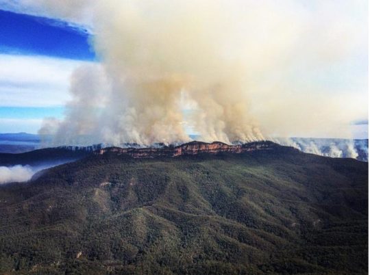
“These operations are crucial for managing vegetation fuel loads and reducing the intensity and spread of potential wildfires.” – “crucial” for whom? An expanding Sydney human housing sprawl? So the NSW Government’s volunteer and under-resourced RFS has less forested native habitat risk and so less work to do in the event of wildfires because year-on-year there is less forested native habitat left. Perpetuation that long term strategy, there will eventually be little or no native habitat left across NSW. So down the track a future NSW Government may well decide that the RFS is therefore no longer needed and so make the organisation redundant. Sydney that has been deliberately morphed by successive governments (state and federal) into the ‘Greater Sydney Region‘ has, on paper, swallowed whole the ‘Blue Mountains Region‘ (see NSW Planning map below) , presuming its world heritage status is now just outer-upper western Sydney parkland for the rezoning offing. Allowing the 2019 megafires to incinerate 80% of the Greater Blue Mountains World Heritage Area, clearly has achieved the NSW Government’s intended devaluation of the UNESCO recognised “Outstanding Universal Value” of all the Eucalypts, and is wholly consistent with a usurpation agenda for an even Greater Sydney megalopolis.
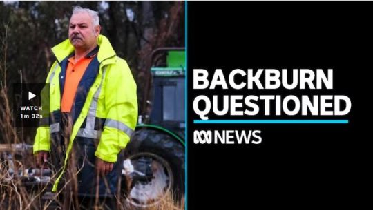
“The planned hazard reduction burns in Blue Mountains National Park underscore the ongoing commitment of NSW authorities to wildfire risk management and community safety. By taking proactive measures to manage fuel loads, the NPWS aims to mitigate the impact of wildfires, ensuring the protection of both natural landscapes and residential communities.” The spin doctoring clearly by outsourced consultants with Communication Degrees is palpable here. It’s more repetition of contrived persuasive terms: “planned hazard reduction burns”, underscore the “ongoing commitment of NSW authorities to wildfire risk management and community safety”. Ask the residents of Mount Wilson who lost their homes by RFS reckless arson in 2019 on this point! “taking proactive measures to manage fuel loads”, “the NPWS aims to mitigate the impact of wildfires”, “ensuring the protection of both natural landscapes and residential communities.” What so burning the natural landscapes to protect them? Seriously? In truth it is all about avoiding bad publicity when the RFS lights a high risk fire on 14th December 2014 causing homes to be incinerated like at Mount Wilson. “The state coroner has confirmed that a bushfire that destroyed homes in Mt Wilson, Mt Tomah, Berambing and Bilpin in December 2019 was caused after a planned RFS backburn jumped Mt Wilson Road.” [SOURCE: ‘Bushfire inquiry: Mt Wilson backburn to blame‘, BMG, 2nd April 2024]
RFS MOUNT WILSON ARSON: Sam Ramaci, like several of his neighbours, claims a back-burn lit by the RFS on December 14, 2019, was responsible for the destruction of his cool room, tractor and the property that was to fund his retirement. “If they hadn’t started the back-burn, my house would be still standing,” he said. (The NSW Government has refused to compensate him and others (nor even apologise) for the reckless misjudgment of its RFS – a NSW Government agency. Who can afford a class action? [Go to Video Link]
The Mount Wilson fire was the sixth backburn to escape along the southern containment line that was intended to protect the upper Blue Mountains from the Gospers Mountain Fire.
What sane person would join the Rural Fire Starters?
Bush arsonists have a psychological compulsion to set fire to see fire . It’s a ritual – they’re eyes light up. “Behold, The Fiery Cross !...”
NPWS is beholden to NSW Planning
A headline environmental protection agency that is supposed to be caring for national parks reporting to a state land use planning authority (aka Development). Is this a warped governmental portfolio conflict of interest of what? Liberal-Labor-Liberal…? Same Same.
The Regional Map of NSW according to the NSW Government’s Department of Planning and Environment fiefdom in 2024. Note that the Blue Mountains Region no longer exists, but has become annexed by the ever expanding ‘Greater Sydney Region’ in the mindset of Macquarie Street’s urban expansionism campaign. Mount Victoria a Sydney suburb now? Lookout Broken Hill!
Deforestation of Australia since colonisation and its usurpation from 1788. Remnant native forests and their native habitat have been decimated to ecologically unsustainable islands. The entire pre-colonial eastern seaboard of the continent was originally blanketed by native forests unbroken, extending about 600km inland. [SOURCE Google Maps – satellite view, April 2024]
It’s no wonder that Australia continues its record of perpetuating the world’s worst rate of wildlife extinctions. It’s akin to countries like Madagascar. It’s all hell bent on serving the Human Plague Order, currently 8.1 Billion! and in 2024 growing (and demanding more) by $75 million p.a. The current population of Australia is 26,654,200 as of Monday, April 29, 2024. Compare Australia’s Federation census of 1901 counted 3,773,801 people across Australia. [Check: Census Bureau Projects U.S. and World Populations on New Year’s Day; and ^https://www.worldometers.info/world-population/]
But wait there’s more bush arson planned…
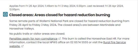
An update last Friday, 26th April 2024 (just days ago), the NSW Government’s environmental department website again posted a media release advising of its further planned “Hazard reduction burn in Blue Mountains National Park” for the weekend.
It read as follows:
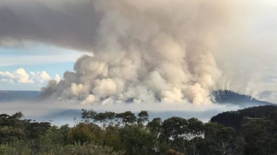
“The NSW National Parks and Wildlife Service (NPWS) with assistance from the NSW Rural Fire Service is conducting a hazard reduction burn in Blue Mountains National Park starting Sunday 28 April, weather permitting.
Staff from Metro South West and Blue Mountains regions undertaking the Pisgah Ridge hazard reduction burn near Glenbrook in the Blue Mountains National Park The hazard reduction burn will focus on an area south of Woodford, in the mid-mountains, and cover a total area of about 400 hectares. The burn aims to reduce fuel hazards and assist in the protection of property in the surrounding Woodford, Hazelbrook and Linden areas.
Fire trails around the burn area, including Bedford Creek, will be closed to the public, along with the Murphy’s Glen camping and day use area. The campground will be reopen when it is safe to do so.
Smoke may be seen in the area for up to a week after the initial operation.
The burn is one of many hazard reduction operations undertaken by NPWS each year, many with the assistance of the NSW Rural Fire Service (RFS) and Fire and Rescue NSW.
All burns around the state are coordinated with the NSW RFS to ensure the impact on the community is assessed at a regional level.
People with known health conditions can sign up to receive air quality reports, forecasts and alerts via email or SMS from the Department of Climate Change, Energy, the Environment and Water. For health information relating to smoke from bushfires and hazard reduction burns, visit NSW Health or Asthma Australia.
More information on hazard reduction activities is available at NSW Rural Fire Service and the NSW Government’s Hazards Near Me website and app.”
Asthma sufferers? – NSW Government care factor?
Carbon emissions? – NSW Government care factor?
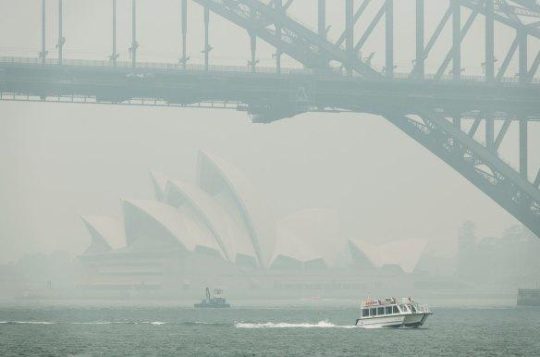
10th December 2019: NPWS world heritage Eucalyptus woodsmoke enveloping Sydney from what started as an abandoned pile burn off Army Road near Gospers Mountain in the distant Wollemi NP two months prior on 26th October 2019. She’ll be right, eh NPWS boss David Crust?
The RFS is one of the planet’s highest emitters of airborne carbon particulates by way of causing mass wood-smoke by repeatedly lighting bushfires and ignoring wildfires. Wood smoke we feel is a tad more polluting than humans exhaling carbon dioxide. But then how many humans on the planet?
Yet the climate change cult remains quiet on this more serious global problem. Why so selective about a lesser pollutant in the hysterical ideology that has morphed from ‘Global Warming‘ (Wallace Smith Broecker’s term of 1975) to ‘The Greenhouse Effect‘ (Mike Hulme’s term in 1994) to ‘Climate Change Scientology‘ (U.S. National Academies of 2014) to currently ‘Climate Crisis‘ actually predating the former (U.S Vice President Al Gore of 2007).
The RFS and NPWS press on regardless – as it’s not carbon dioxide, so all good!
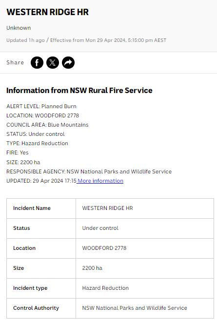
Here’s the latest bush arson schedule to further set fire to the still unburnt native habitat of the Blue Mountains:
RFS:“It’s ok love, it’s good for the bush. She’ll be right.”
It’s an age old mentality of the fox charged to look after the chickens. Both the NPWS and RFS have a cultural attitude that the national parks are NOT to be protected, despite the NPWS delegated to so-called manage NATIONAL parks across New South Wales (NSW). That is despite the Rural Fire Service (RFS) charged with putting out wildfires.
That perverted culture is conditioned to regard native habitat only as a ‘fuel’ that burns and so NOT habitat but a ‘hazard’ to be controlled and burned to prevent it burning. If there is no habitat left, then the meathead rationale, no hazard, so job done! Of recent times the spin doctors in government seconded as contractors with Communications Degrees (aka the art of spin) have softened the community sell of these ‘hazard reductions’ to ‘prescribed burns” to justify and take some noble authority from on high that the BUSH WAS ORDERED TO BE BURNED, WE HAVE NO CHOICE !
All their fire trucks are filled with more flammable liquids light a bushfire than water to put it out. ‘RFS’ should stand for for Rural Fire Starters.
Blue Mountains World Heritage?
Eventually the bush grows back but with a vastly different flora community make up. The biodiversity is gone. The wildlife don’t come back from the dead.
One of countless Koalas tragically burned to death in her native habitat during the Blue Mountains megafires of 2019. They won’t come back. [This website is not suitable for children to view]
This native Koala would have looked something like this:
National parks throughout Australia over the 236 years since colonisation and its continent-wide deforestation, land use destruction and introduced bushfires, have consistently and hatefully made Australia’s ecological landscape very very quiet and devoid of wildlife.
The 2019 mega bushfires of NSW that the NPWS and RFS let get out of control over months, wiped out 80% of the Greater Blue Mountains World Heritage Area, including rare remnant koala communities and hosts of other at-risk wildlife and their special native habitat that NPWS has no clue of the statistical losses. NPWS does not manage, it mismanages, else just oversees politically drive projects like multi-million dollar tourists track upgrades to benefit humans. The NSW State Government tasked to look after UNESCO world heritage on behalf of the Australia Government?
This habitat reduction regime is to burn the remaining 20% that didn’t cop the 2019 wildfire megablaze. They call this “stewardship”? All trust in the NSW Government to protect world heritage has long gone out the window.
The ‘NPWS’ is a misnomer
‘NPWS” is an abbreviation for the National Parks and Wildlife Service in the state of New South Wales.
Logo of the NPWS
The problem is that this government bureaucracy is supposed to be the governmental (public) custodian for national parks is misleading:
NPWS is not national, rather it is only a NSW governmental sub-department. Governmental ‘management’ of national parks is not national, rather each state and territory has its own national parks, and the Australian Government is not involved – so a bizarre and misleading naming tradition;
NPWS does NOT look after wildlife. Native habitat in these ‘national parks’ is supposed to be protected. Yet every year vast selected areas are burnt deliberately else left to burn on a grand scale, so killing wildlife and destroying their habitat.
As a consequence, the NPWS deserves to be more appropriately renamed as ‘NSW Parks Service‘ just like in Victoria, the Victorian Government calls its equivalent ‘Parks Victoria‘.
On the relevant NSW Government’s website pertaining to its NPWS, it explains that the NPWS is part of a sub-department called ‘Environment and Heritage, which in turn:
“Environment and Heritage is part of the Department of Climate Change, Energy, the Environment and Water.
Our vision is for a thriving, sustainable and resilient New South Wales.Environment and Heritage works with communities, businesses and governments to protect, preserve and strengthen the quality of our natural environment and heritage. We do this through active stewardship that supports a healthy New South Wales.We are committed to creating thriving environments, communities and economies that benefit the people of New South Wales.”
The three most trendy feel-good terms above include: “thriving”, “resilient” , active stewardship”. Pure motherhoodism by the contracted young spin doctors with a Communications Degree. So where are the published wildlife regional extinction stats before and after the Blue Mountains 2019 megablaze?
Recall Tathra Sunday 18 March 2018, the consequence of the RFS deliberately lighting a bushfire on a 38 degree Celsius (100 Fahrenheit) gusty day upwind of this coastal village. [Read Our Article: ‘Bushfire Scenario Was Not Rocket Science‘
[8] ‘Impact of the 2019-20 Mega-Fires on the Greater Blue Mountains World Heritage Area, New South Wales‘, 20221129, by P Smith and J Smith, Issue Vol. 144 (2022), Proceedings of the Linnean Society of New South Wales, ^https://openjournals.library.sydney.edu.au/LIN/article/view/17079
The Rural Fire Starters (RFS) of New South Wales have set fire to Blue Mountains World Heritage yet again.
They call it ‘Hazard Reduction’ because they deem native habitat to be a hazardous fuel, nothing more. Government is dominated by men and women in power their sixties (Baby Boomers currently). Their worldview is anthropcentric if not a contempt for ecology and the survival conservation of Australia’s wildlife fauna. They consider native forests to be mere ‘parks’ for human recreation. Their forebears happily shot wildlife as vermin.
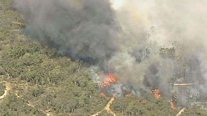
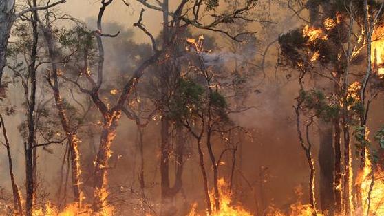
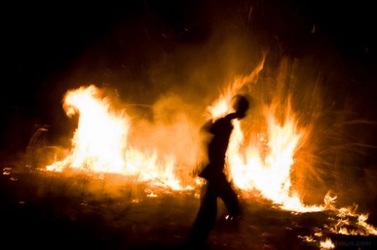
So yet again more vast areas of native forest habitat have been incinerated as if it were a wildfire. The hazard reduction flames reach fully up into the tree canopy in the same way. Hazard Reduction is government condoned bush arson. It is a prime cause of local wildlife extinction.
Hazard Reduction adversely alters Forest Ecology
Hazard Reduction used to the intensity, canopy height and broad scale of a wildfire is no different to wildfires in ecological impact. Deliberate bush arson whether by arsonists or government sanctioned, harm native habitat. The penchant for increased fire regimes out of fear of government incapacity to deal with wildfires, has inculcated a mindset of a ‘burn the bush before it burns‘ mentality.
When applied to moist Closed Forest ecosystems, hazard reduction dries out the delicate moist microclimate. The complex topsoil chemistry is destroyed. Only fire resistant flora regenerate; other species die and do not return. The forest become more bushfire prone. Wildlife perishes especially territorial wildlife. The close forests become drier Open Forest Parks – ones you can more easily walk through.
“Bushfire danger is increasing as a consequence of climate change predicted by scientists. Heavy logging and burning of forests increases rather than decreases flammability. Forests permitted to exist in their natural state (with dense shading canopies and intact boundaries) lose less moisture from drying wind and direct sun. An unlogged forest can remain cooler and damper – for longer. It has been demonstrated that it can slow, and even halt a fire.” – Dr Chris Taylor, Ecologist at the University of Melbourne, in the journal Conservation Letters 2014.
“Fuel hazard is often assumed to increase with fuel age, or the time-since-fire. However, studies on fuel hazard in long-unburned forests are scarce. We measured overall fuel hazard in Eucalyptus forests and woodlands in south-eastern Australia at 81 sites where time-since-fire spans 0.5 years to at least 96 years. Overall fuel hazard was higher in forests and woodlands burned 6–12 years previously than those unburned for at least 96 years.
The probability of high, very high or extreme overall fuel hazard – which is an operational threshold considered to equate with almost no chance of wildfire suppression in severe fire-weather – was highest 0.5–12 years post-fire, and lowest where fire had not occurred for at least 96 years. Frequent burning can maintain forest understorey in an early successional ‘shrubby’ state, leading to higher overall fuel hazard than forests where a lack of fire is associated with the senescence of shrubs.
Protecting long-unburned sites from fire and managing to transition a larger proportion of forest to a long-unburned state may benefit fuel-hazard management within these forests in the long-term.” (Source: International Journal of Wildland Fire, 20180723, (Refer Note 1 in Further Reading).
Hazard Reduction fuels Carbon Emissions
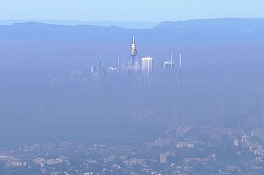
The toxic wood smoke blankets communities and the entire Sydney basin as the prevaling westerly wind drives the choking smoke for a hundred kilometres.
Thick smoke from a prescribed arson by the RFS in precious forext habitat around Faulconbridge and Springwood has blanketed the entire Sydney basin just like what happens regularly in Beijing.
The wood smoke is expected to last for days and health warnings have been issued by the New South Wales government who approved the burning. NSW Health has warned that people with existing heart and lung conditions should avoid outdoor physical activity. NSW’s Office of Environment has labelled Sydney’s air quality “poor” and warned people with health issues to stay indoors.
Outside the RFS Bushfire Season (September to March), this is the contra Habitat Reduction Season (April to August). If the Greater Blue Mountains World Heritage Area isn’t subjected to arson wildfire in the on-season, it is targeted by arson habitat reduction in the off-season. The impact is the same.
“These are important controlled burns which will reduce the risk to people and properties from bush fires,” NSW RFS said in a statement.
Up to 30 tonnes of CO2 per forested hectare is emitted by bushfires and hazard reduction alike, according to Philip Gibbons , Senior Lecturer at the Australian National University; more than coal-fired power stations.
“Burning biomass inevitably releases CO₂ (Carbon Dioxide), CH₄ (methane), N₂O (Nitrous Oxide) and other greenhouse gases (GHG) to the atmosphere. Emissions from vegetation fires account for about 3% of global GHG emissions. Bushfires in Australia burn over 500,000 km² annually, mainly in the northern half of the country. They account for about 6-8% of global fire emissions and contribute significantly (about 3%) to the nation’s net GHG emissions.” – Matthias Boer, Researcher, Western Sydney University.
Bushfire smoke contains particulate matter, respiratory irritants and carcinogens such as benzene and formaldehyde. These can travel for thousands of kilometres. Hazard reduction burns, which are being conducted more frequently due to climate change, also contribute to increased pollution.
In 2009 bushfires, back-burning and hazard reduction emitted an amount of CO2 equivalent to 2% of Australia’s annual emissions from coal-fired power. Bushfires burnt an area of forest greater than Tasmania to generate CO2 emissions equivalent to a year of burning coal for electricity. Bushfires must burn an area of forest the size of New South Wales to generate CO2 emissions equivalent to a decade of burning coal for electricity.
Wildfires and hazard reduction across Australia released millions of tonnes of carbon dioxide and carbon monoxide into the atmosphere, equivalent to more than a third of the country’s CO2 emissions for a whole year, according to scientists.
The climate costs are dire because of the type of forest that burned, according to Mark Adams of the University of Sydney. “Once you burn millions of hectares of eucalypt forest, then you are putting into the atmosphere very large amounts of carbon.”
Because hazard reduction burns have been increasingly more widespread and deliberately encouraged to blanket a wide landscape , rather than edge low level and mosaic in pattern, hazard reduction burns are litteldifferent in impact that wildlfires. A high-intensity burning into the tree canopy causes equivalent forest carbon and greenhouse gas (GHG) emissions.
Australia’s total emissions per year are around 330m tonnes of CO2. Adams’ previous research has shown that the bush fires in 2003 and 2006-07 had put up to 105m tonnes of carbon dioxide into the atmosphere because they burned up land carrying 50 to 80 tonnes of carbon per hectare.
This time, however, the forests being destroyed are even more carbon-rich, with more than 100 tonnes of above-ground carbon per hectare. The affected area is more than twice the size of London and takes in more than 20 towns north of Melbourne, so the CO2 emissions from this year’s disaster could be far larger than previous fires.
So ‘hazard reduction’, ‘fuel reduction’, ‘prescribed burning’, or indeed the more honest term ‘government arson’ – must cease because it releases vast quantities of CO2 and other toxic chemicals that pollute the atmosphere.
“The world’s forests are crucial to the long-term future of the planet as they lock away millions of tonnes of carbon dioxide,” said Robin Webster, a climate campaigner at Friends of the Earth. “More must be done to protect them – deforestation is having a devastating effect and as climate change takes hold, forest fires like those in Australia are likely to become more frequent.”
The carbon dioxide emissions from forest fires are not counted under the agreements made by countries in the Kyoto Protocol, though it is being considered for inclusion in the successor treaty that will be debated later this year in Copenhagen. The usual reasoning behind it was that, with any fires, new growth of vegetation would take up any extra CO2 that had been released. “That is true to a point, but if the long-term fire regime changes – we are now starting to have more fires – we may completely change the carbon balance of the forest,” said Adam.
He added: “All informed scientific opinion suggests that whatever new protocol is signed [at the UN summit] in Copenhagen or elsewhere will include forest carbon, simply because to not do so would be to ignore one of the biggest threats to the global atmospheric pool of carbon dioxide, the release of carbon in fires.”
“Nature reserves are areas of land in predominantly untouched, natural condition, with high conservation value. Their primary purpose is to protect and conserve their outstanding, unique or representative ecosystems and Australian native plants and animals.”
NPWS has become more an agent for Tourism than Conservation
The New South Wales National Parks and Wildlife Service is a state government entity and the sole custodian of the Blue Mountains World Heritage Area, the state’s 870 national parks, and nature reserves. It’s management has the same recreational mindset of the RFS, that national parks are set aside areas of recreation for humans to play in, not remnant habitat sanctuaries to be protected across Australia’s otherwise deforested landscape.
Successive state governments have slashed the departments funding to a skeleton service and merged it into other incompatible departments such as repporting to the Department of Planning. The fraud of the naming this grossly underfunded and mismanaged custodial authority warrants a name change to the ‘Parks NSW’, which hereafter we shall refer to them. It functions more like a department of tourism and recreation. Victoria calls its equivalent ‘Parks Victoria’.
It’s logo should better reflect what the Parks NSW actually does in national parks and nature reserves. May be it should take on manicuring council parks and gardens as well. A can of petrol and a tourism sponsor logo like North Face should replace its Superb Lyrebird and Boomerang.
RFS ‘hazard reduction’ inflicted upon Mount Solitary world heritage of a scale the same as a wildfire – all wildlife incinerated so that the ‘national park’ becomes a sterile park.
Rural Fire Service (starters) and National Parks unnecessarily incinerated Mount Solitary, The Jamison Valley and Cedar Valley by indiscriminate aerial incendiary in May 2018. What carbon emissions?
Ironically, today is the government-sanctioned day of the unpaid wildlife arsonist. Give generously.
Not a forest ecologist in sight. Volunteer bush fire-fighters no longer fight bushfires with water, but with petrol.
[2] ‘A comparison of fuel hazard in recently burned and long-unburned forests and woodlands‘, by Dixon KM, Cary GJ, Worboys GL, Seddon J, Gibbons G, 2018, in International Journal of Wildland Fire 27, 609-622, ^https://www.publish.csiro.au/WF/WF18037. Note: Associate Professor Philip Gibbons, currently an Associate Professor at The Fenner School of Environment and Society at The Australian National University where he teaches courses related to biodiversity conservation. He has published over 100 journal articles and book chapters, including three books.
“For those who object to the burning of ‘our’ bushland for fire ‘hazard’ reduction, perhaps they could assist by adopting..the method of raking the forest floors.”
– Rod Tuck, Katoomba.
Finns beg to differ and send a message that RFS unpaid slaves are just redneck knuckle-dragging dumb arses..
Why did three wildfires start today in north western Sydney in protected reserves of Sydney’s remnant Cumberland Plains Woodland?
The fires all started around midday during high gusty wind conditions and unseasonally high temperatures. There was no lightning to speak of, so all three fires must have been caused by people.
Reckless burnoffs? Deliberately lit? By the same people? By developers wanting to undermine the Cumberland Plain Woodland and so extend their sprawl?
Whether it was bush arson or recklessness will be a matter for bushfire investigations which need to be mandatory for each and every wildfire. A forth wildfire at Winmalee in the nearby Blue Mountains (the ‘Hawkesbury Road Winmalee Fire‘) was purportedly a neglected hazard reduction burn – the Rural Fire Starters fuelling more work for themselves.
What did each wildfire cost – economic loss, infrastructure loss, productivity loss, direct firefighting costs, indirect costs, social costs? These are never measured or reported. The ecological costs are always ignored because ecology is not deemed to be valuable in our current society. How much death and harm has been infliced upon Windsor Downs Nature Reserve? Such value questions are beyond the thinking of our current society.
The RFS only prioritises saving human life and property. It thus has no different role than the NSW Fire Brigade. So the RFS should not exist. It only exists because the New South Wales government does not want to properly pay for firefighting. The RFS exists as unpaid volunteers so that the NSW government can divert hundreds of millions in taxes to other priorities it somehow considers to be more important.
Then the NSW government appeals for more volunteers to do its dirty work for free.
.
Whereas in New South Wales, a NSW Fire Brigage professional firefighter gets paid $29 an hour minimum. There will be many families that would dearly desire to receive that for their unpaid volunteering efforts.
“At Richmond Road and Bennett Road at Windsor, the RFS (New South Wales Rural Fire Service) says a grassfire could impact properties around George Street and the area of Bligh Park. The fire has crossed Garfield Road and is burning in the Windsor Downs Nature Reserve.”
The fire authorities have labelled this current fire the ‘Richmond Road Grass Fire‘, so will the records of the fire will be just scattered or erased? Today’s initial account of the fire on the official Rural Fire Service website reads thus :
“..A grass fire burning in the area of Richmond Road and Bennett Road at Windsor”. The fire is burning on both sides of George Street, South Windsor and both sides of Richmond Road. The fire is burning under strong northerly winds. An Emergency Alert telephone message has been sent to residents in these areas.
There is the potential for the fire to impact on properties around George Street and the area of Bligh Park. The fire has crossed Richmond Road and is now burning in the Windsor Downs Nature Reserve.”
.
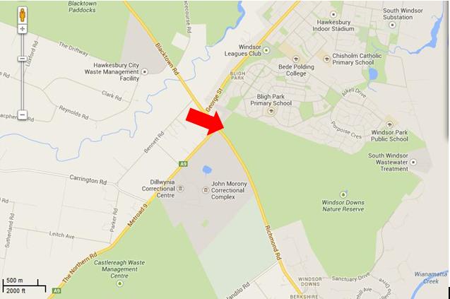
To put this into geographic perspective, this is a presumed map of the affected area, in absence of RFS public transparency:
The presumed ignition of the Richmond Road Grass Fire from Bennett Road, Windsor Downs
(outer north-western Sydney Metropolis)
[Source: Google Maps 2013]
.
<<Emergency warnings have now been issued for four bushfires in Sydney’s far north west, as temperatures in the city exceed 30 degrees with strong northerly winds.
The RFS says five firefighters have sustained smoke inhalation and two have received minor burns.
The fires are at Castlereagh, Richmond, Marsden Park, and Winmalee where one property is alight. At Richmond Road and Bennett Road at Windsor, RFS says a grassfire could impact properties around George Street and the area of Bligh Park. The fire has crossed Garfield Road and is burning in the Windsor Downs Nature Reserve. >>
.
[Ed: Garfield Road is in Riverstone, not Richmond, and is also quite distinct from the separate fire at Windsor Downs. Media reporting has been misleadingly false, overlapping and confused and likely due to naive junior desktop journalism. Worse is that the RFS report is equally confused. Fortunately no person died relying upon officialdom, but the wildlife count is never published].
.
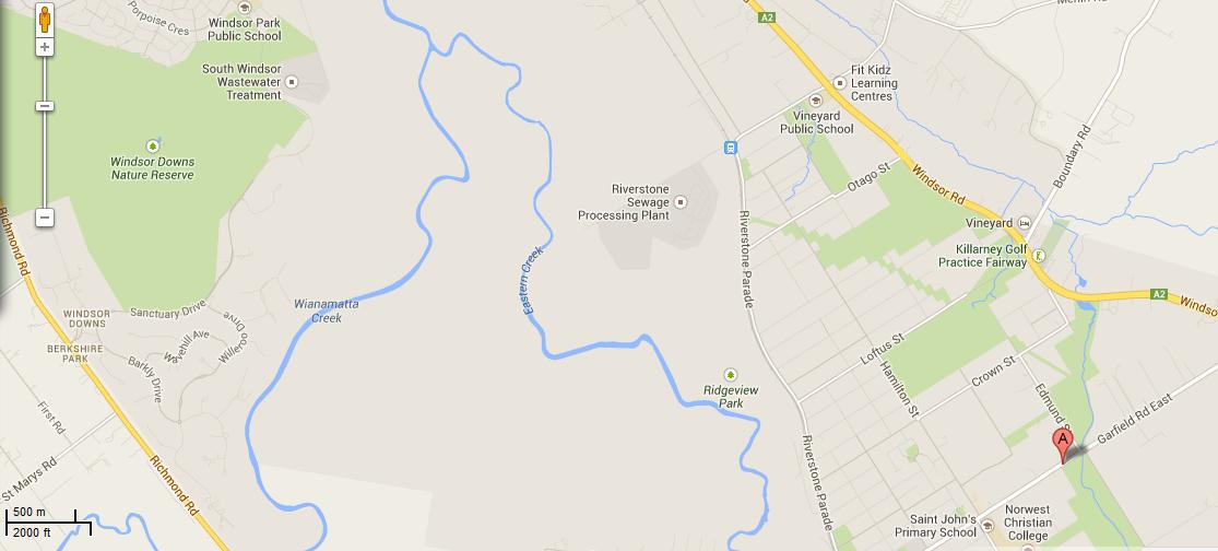
.Map showing the juxtaposition of the Windsor Downs Nature Reserve over 3 km north west from Garfield Road in Riverstone.Journalists have a lot to answer for when it comes to fact checking during emergencies.
[Source: Google Maps 2013, click image to enlarge]
.
<< About 3,200 homes in the Richmond area have lost power and Endeavour Energy says it is working to get the supply back. The RFS says the fire is burning intensely under strong winds.
In Marsden Park, a grass fire is burning out of control and has crossed Garfield Road. While at Castlereagh, near Penrith, an emergency warning was issued around noon (AEST) for a fire which has destroyed a shed and burned 60 hectares. About 50 homes are thought to be under threat. The fire is burning around properties on Devlin Road and is moving towards homes on Nutt Road.
RFS Inspector Ben Shepherd says the conditions are difficult for firefighters.
RFS Inspector Ben Shepherd:
“I’m currently sitting on Nutt Road and the fire is moving quickly towards some homes in that area. The actual fire itself is putting up a huge column of smoke… and the wind continues to be quite strong. Because of that, that’s starting to send a couple of spot fires ahead of the main fire front itself.”
.
Local resident Kelly Elson has been evacuated from her home near the fire front. She says she first noticed the fire at about 10:30 this morning.
Windsor resident Troy Evans says that fire started in grass near his house on Bennett Road.
Windsor resident Troy Evans:
“So I went and told the firies ‘you better get a couple of trucks round here real quick’ which they did, luckily. They got the place under control then the wind turned and it’s just roared up through next door, jumped the road, it’s gone through the church, it’s over in the bus bay, it’s meant to have taken a couple of houses out in Bligh Park. Now it’s on it’s way into the jail, it’s just crazy.”
.
A very high fire danger alert has been issued for the Illawarra, Sydney, the Central Ranges, the Hunter, the north west and the north coast. More than 40 uncontained bushfires are currently burning across New South Wales.
Mr (RFS Commissioner Shane) Fitzsimmons says it is hot, dry and windy in most of the state today, with seven districts in very high fire danger. He says he is worried about the unseasonally warm start to spring on the back of a dry winter.
The RFS is urging property owners in semi-rural and rural areas to think about the conditions before they burn off land.”
.
[Ed: Fitzsimmons, why blame the weather and not the landholder who is accused of causing the ignition?]
[Ed: So theRFS is urging property owners in semi-rural and rural areas to think about the conditions before they burn off land.
Is this head office code for the known landholder who caused the fire and the RFS being too public servant skin timid to lay charges? So why is the landholder in Bennett Road not under arrest for suspected arson?]
.
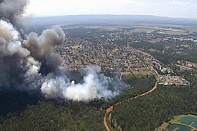
The fire inside the Windsor Downs Nature Reserve today
Cumberland Plain Woodland including the Windsor Downs Nature Reserve, the nearby Castlereagh Nature Reserve and Agnes Banks Nature Reserve, all fall under the custodial management responsibility of the National Parks and Wildlife Service New South Wales – a state body.
Windsor Downs Nature Reserve features.. << an historic windmill and water tank protects a number of endangered plant communities and includes species such as the broad-leafed ironbark, grey box, scribbly gum, narrow-leafed angophora, pea flowers and a species of geebung.
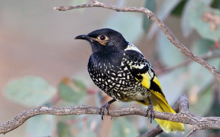
Several bird species have been recorded – the red-capped and hooded robins, white-winged choughs, buff-rumped and yellow-tailed thornbills and the endangered regent honeyeater – which are usually found in the drier habitats of the central west slopes. >>
Windsor Downs Nature Reserve is not just set aside for picnics. It is a remant ecological community with the fast disappearing Cumberland Plain Woodland. It is supposed to be protected.
.
<< The Cumberland Plain Woodland is the name for the distinct groupings of plants that occur on the clay soils derived from shale on the undulating Cumberland Plain in central New South Wales. The most commonly found trees in the woodland are Grey Box Eucalypts Eucalyptus moluccana, Forest Red Gums Eucalyptus tereticornis, Narrow-Leaved Ironbarks Eucalyptus crebra and Spotted Gum Eucalyptus maculata. A variety of other lesser-known eucalypts as well as shrubs, grasses and herbs are also found. It is the dominance of Grey Box and Forest Red Gum that makes the community distinctive.
In 1877 Cumberland Plain Woodland covered 107,000 hectares occupying approximately 30 per cent of the Sydney Basin. This community type was once widespread in the Plains but has been reduced to a few fragmented stands by human use for farming, industry and housing. Today less than six per cent remains in small fragments scattered across the western suburbs of Sydney, totalling only 6400 hectares. The remaining fragments occur in areas subject to intense pressure from urban development.
Although some areas occur within conservation reserves, this is in itself not sufficient to ensure the long-term survival of the community unless the factors threatening the integrity and survival of the community are eliminated.
The remaining stands of this ecological community are threatened by the spread of the Sydney suburban areas. Threats include clearance for agriculture, grazing, hobby and poultry farming, housing and other developments, invasion by exotic plants and increased nutrient loads due to fertiliser run-off from gardens and farmland, dumped refuse or sewer discharge.>>
[Ed: and of course ‘bushfire’, which the government does not like to include out of embarassment of neglect, yet which is causes the most devastating impact].
Cumberland Plain Woodland in the Sydney Basin Bioregion – proposed critically endangered ecological community listing
.
<< The NSW Scientific Committee, established by the Threatened Species Conservation Act, has made a Preliminary Determination to support a proposal to list the Cumberland Plain Woodland in the Sydney Basin Bioregion as a CRITICALLY ENDANGERED ECOLOGICAL COMMUNITY on Part 2 of Schedule 1A of the Act and as a consequence, to omit reference to Cumberland Plain Woodland from Part 3 of Schedule 1 (Endangered Ecological Communities) of the Act. The listing of Critically Endangered Ecological Communities is provided for by Part 2 of the Act.
The Scientific Committee has found that:
1. Cumberland Plain Woodland was listed as an Endangered Ecological Community under the Threatened Species Conservation Act 1995 in June 1997 (NSW Scientific Committee 1997). Since this listing, a large volume of new data and analyses have become available. In addition, a nomination to change the status of Cumberland Woodland to Critically Endangered status has been received. This Determination addresses additional information now available in accordance with current listing criteria under the Threatened Species Conservation Regulation 2002.
2. Cumberland Plain Woodland is the name given to the ecological community in the Sydney Basin bioregion associated with clay soils derived from Wianamatta Group geology, or more rarely alluvial substrates, on the Cumberland Plain, a rainshadow area to the west of Sydney’s Central Business District. >>
<<..high frequencies of fires may result where fragmentation increases the interface between urban areas and bushland, as this results in increased arson, car dumping, planned fuel-reduction fires and accidental ignitions.
High fire frequencies are associated with reduced diversity of native plant species in Cumberland Plain Woodland (Watson 2005). ‘High frequency fire resulting in disruption of life cycle processes in plants and animals and loss of vegetation structure and composition’ is listed as a Key Threatening Process under the Threatened Species Conservation Act 1995.
The season of fire, which may be altered as a consequence of hazard reduction fires, may also influence the species composition of the grassy woodland understorey (Knox & Clarke 2006; Benson & von Richter 2008).
Disruption of ecological processes associated with alteration of fire regimes contributes to a very large reduction in ecological function of the community. >>
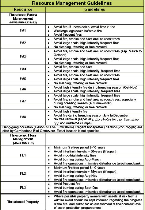
The official Fire Management Strategy has been conveniently removed from public access on the National Parks and Wildlife Service (NPWS) website.
However, the following extracts from the similar and nearby Agnes Banks Nature Reserve are instructive as to the approach taken by NPWS management on all nature reserves across the Sydney Basin that comprise remnant ecology of the Cumberland Plain Woodland.
[Ed: Disturbingly noted is that the NPWS ‘ecological’ policy is that it ok to burn these woodland reserves every 8 years. So government care factor about bushfire impact?]
.
<<..little research has been undertaken into fire management prescriptions for Cumberland Plain woodland and forest associations when compared to the nearby Hawkesbury sandstone communities.>>
~ Windsor Downs Nature Reserve et al. Plan of Management (NPWS 1999,p.18)
.
The official Bureau of Meteorology had in the days prior, forecast strong gusty north westerly winds for the western Sydney region for both yesterday and today, following a few days of calm winds. The Rural Fire Service would have been well aware of this forecast, the extreme bushfire conditions that this posed and the considerable escalated risk of damaging wildlfires.
The subsequent actual weather observations for Richmond are telling. Look at the 10th. The arsonists know what they are doing.
Reliant mainly on public calls to ‘000’, fire trucks and road-routed volunteers, the RFS continues to be grossly under-equipped to handle wildlfires in a timely and effective manner, which increasingly to many is unacceptable to bushfire prone communities in this now 21st Century.
Steadily year on year, the last bushland reserves that provide critical remnant habitat around Sydney are being destroyed. Before long the only bushland will be that in suburban gardens, and the wildlife will be finally made regionally extinct.
.
Critically Endangered Regent Honeyeater
(Anthochaera phrygia)
A native bird species dependant upon a disappearing habitat
Humans obliterated its habitat for logging, farming and housing
Then we constrained it to a few nature reserves like Windsor Downs,
Then we burnt the reserve.
<<Authorities say they believe a fire that destroyed a home at Marsden Park in Sydney’s west on Tuesday was deliberately lit. Investigators have also not ruled out that an arsonist may have caused a blaze at nearby Londonderry. Police are now calling for witnesses to help identify the person responsible for sparking the Marsden Park fire.
Assistant Commissioner Alan Clarke says it is believed the fire began on Grange Avenue just after midday on Tuesday.
.
Alan Clarke:
. “There are crime scene indicators at the source of that fire that would lead us to suspect arson activity. I really can’t tell you more than that at the moment. It’s mainly our crime scene indicators and forensic evidence that would have us raise that suspicion. If anyone has information, if anyone saw any suspicious activity in or around that fire location, any part of it… please pass that information on for the benefit of police.”
.
Rural Fire Service Deputy Commissioner Rob Rogers has confirmed another serious fire at Winmalee, in the lower Blue Mountains, was caused by a hazard reduction burn conducted by the NSW National Parks and Wildlife Service.
.
Rob Rogers:
“That fire was burn on the weekend, it was patrolled on Monday, there was smouldering activity. That fire then jumped containment lines on the Tuesday and became an active fire. The winds on that day did exceed forecast and they were around 90 kilometres an hour, and obviously that tested the control lines on that hazard reduction and it did escape. In these strong winds branches came off trees, hit the powerlines, the powerlines were brought down, they ignited grass in that area and that was the cause of that fire. You would have to obviously be suspicious that it did come from the hazard reduction, given that it was in a very close proximity to it.”
.
Investigators have found a fourth fire that began on Richmond Road at Windsor Downs was sparked by downed power lines. The investigation into a fire that closed the M1 motorway, formerly known as the F3, north of Sydney yesterday is continuing, with another hazard reduction burn the suspected cause. Assistant Commissioner Alan Clarke has warned those that deliberately light fires or cause them through negligence will be caught.
.
Alan Clarke:
“Last year we arrested 87 individuals and they faced charges in respect of bushfire and fire related activity for 117 charges. We know this year again we will be putting offenders before the court. It’s sad but it’s true.”
"We're coming to you from the custodial lands of the Hairygowogulator and Tarantulawollygong, and pay respects to uncle and grandaddy elders past, present and emerging from their burrows. So wise to keep a distance out bush."


 It’s logo should better reflect what the Parks NSW actually does in national parks and nature reserves. May be it should take on manicuring council parks and gardens as well. A can of petrol and a tourism sponsor logo like North Face should replace its Superb Lyrebird and Boomerang.