Archive for the ‘Blue Mountains (AU)’ Category
Friday, February 4th, 2011
The local Blue Mountains Gazette newspaper of the Blue Mountains (west of Sydney) yesterday reported the harming of wildlife in the Blue Mountains National Park (read below).
.
$100 REWARD
Disgusted at this wildlife crime, the editor is offering a one-off reward of $100
for the identification of the offender(s) responsible for this wildlife bashing
and its reporting to the National Parks and Wildlife office at Blackheath, which secures a conviction.
.
Contact the editor : info@habitatadvocate.com.au
.
.
‘Snake bludgeoned at Blackheath‘
by Krystyna Pollard (journalist), 20110202, page 11.
.
‘National parks officers have condemned the brutal bludgeoning of a female (eastern) brown snake carrying 19 eggs at Blackheath’s Evans Lookout.
The snake was found on January 13 by a member of the public in her nest alive but with a broken back, according to National Parks and Wildlife Service (NPWS) ranger Vanessa Richardson.
“This brown snake had lived in the vicinity of Evans Lookout for over five years and lived harmoniously with many visitors who appreciated observing her in the natural environment,” she said in a statement.
“She was well known to NPWS staff and many tour operators enjoyed taking visitors to the site to see a real Australian snake in the wild.”
The snake was taken for treatment, however vets were unable to save her, Vanessa said.
“She was carrying 19 eggs, which were taken to a licensed reptile carer but unfortunately the eggs have collapsed and all eggs have failed,” she said.
“The end result of this is not the death of one brown snake but 20.
“The event has saddened local NPWS staff and wildlife carers and I would urge anyone with information on who may have harmed the snake to come forward.”
While snakes were not as popular with the community as other native wildlife, the NPWS reminded people that all native animals in NSW were protected and each had an important role to play in the ecosystem, Vanessa said.
“I understand if some members of the community are concerned by snakes if they happen upon them inside their homes,” she said.
“However in their natural environment they are overwhelmingly docile unless provoked. In fact most people that get bitten by snakes do so when trying to catch them, annoy them or kill them.
“Snakes preserve their venom to kill prey not people. If you leave them alone it is extremely unlikely they will do you any harm.”
Those caught harming wildlife face on-the-spot fines of up to $500. Higher penalties can be imposed by courts.
Anyone with information about the attack should contact the NPWS Blackheath office on 4787-8877.’
.
.
Comment:
.
This is a deplorable crime against wildlife in native and protected habitat. All flora and fauna in National Parks are protected from harm or disturbance.
In New South Wales under the National Parks and Wildlife Act (1974) Section 98(2), it is unlawful to harm protected fauna. Do do so attracts 100 penalty units and/or a6 month custodial sentence.
As at 7th December 2010, under the Crimes (Setencing Procedure) Act 1999 Section 17, this fine equates to $11,000 (100 penalty units multiplied by $110).
Hopefully, witnesses will come forward so that the perpetrators may be brought to justice, charged and convicted.
The introduced settler culture of Australia’s colonial history, ignorantly perceived Australian wildlife as vermin. The Australian bush and its native flora and fauna, rather than being respected, have long been detested by new arrivals. Such has been the immature misunderstanding due to ignorance. The abnormal fear of snakes (‘ophidiophobia‘) has been at the extreme. Henry Lawson’s 1892 short story ‘The Drover’s Wife’ most famously fueled this cultural fear as he described the snake in the story as having “an evil pair of small, bright bead-like eyes“, as “the enemy” and as the ..”original curse in common with mankind.”
In 2011 in national parks, most of us have surely developed a healthy respect for wildlife and its existence rights. As wildlife habitat shrinks and comes under increasing human threat, is it not humans whom are nature’s vermin?
.
Australia’s Eastern Brown Snake tends to inhabit grasslands and Dry Scheropyll forests situated in dry locations especially with rocky outcrops.
“It is a highly nervous, swift moving and alert snake which usually prefers to prevent confrontations with home owners. It is very quick to flee when seen or threatened but when cornered or attacked can be an explosive snake which will repeatedly lunge and defend vigorously.”
It’s diet is preference to lizards, frogs, other snakes, bird nestlings and baby rabbits, and small rodents such as rats and is therefore valuable in controlling pest species. Mating occurs in October to late Spring females oviduucal eggs are seen in late November to December.
 Eastern Brown Snake
Cresent Head NSW
© Photo by ‘Bev’
http://habitatnetwork.org/PhotoPages/Member-and-AnimalPhotos.htm#E
. Eastern Brown Snake
Cresent Head NSW
© Photo by ‘Bev’
http://habitatnetwork.org/PhotoPages/Member-and-AnimalPhotos.htm#E
.
References:
.
[1] Blue Mountains Gazette, p.11, ‘ Snake Bludgeoned at Blackheath‘, by Krystyna Pollard, http://www.bluemountainsgazette.com.au/news/local/news/general/snake-bludgeoned-at-blackheath/2064355.aspx
[2] Snake Handler.com.au, http://www.snakehandler.com.au/?pid=main&p=30
[3] HabitatNetwork.org http://habitatnetwork.org/PhotoPages/Member-and-AnimalPhotos.htm#E
[3] National Parks and Wildlife Act 1974, Specific Penalties and Orders, Judicial Commission of NSW, http://www.judcom.nsw.gov.au/publications/benchbks/local/National_Parks_and_Wildlife_Act.html
[4] CRIMES (SENTENCING PROCEDURE) ACT 1999, Section 17 ‘Penalty Units’, http://www.austlii.edu.au/au/legis/nsw/consol_act/cpa1999278/
.
Thursday, February 3rd, 2011
 Spotted-Pardalote (Pardalotus punctatus)
© Photo by Julian Robinson
http://www.ozanimals.com/Bird/Spotted-Pardalote/Pardalotus/punctatus.html Spotted-Pardalote (Pardalotus punctatus)
© Photo by Julian Robinson
http://www.ozanimals.com/Bird/Spotted-Pardalote/Pardalotus/punctatus.html
.
.
Ben Esgate [1914-2003] from an interview in October 2002 [Jim Smith PhD]:
.
“Birds and everything like that are getting scarcer.
I reckon that since I have grown up, the bird life on the Blue Mountains has receded by 80%.
Too many bushfires destroy the breeding grounds of many birds, particularly Kookaburras and birds that use hollows. Clearing of land unnecessarily, and always killing the big trees, not the little ones. The big ones make the nests of tomorrow. In the smaller bird line, feral cats are causing no end of trouble. Pardalotes and all that sort haven’t got a chance, anything that builds a nest low in the trees.
Burning off National Parks, and areas adjacent to National Parks, just because the mob squealed because they have gone a built a house near the National Park, and now you have to keep fire from getting it.
The first things that happens then is that you have got to keep burning off around where people live…It might only destroy a bit in this place and a bit in that place, but it is still destroying things.”
“I reckon that I shot every third fox that I ever saw, never mind the ones I went hunting for, in my life. One in every three bit the dust and I’ve shot dozens and dozens and dozens of them. That meant that, including the offspring, there were several hundred foxes less to feed on our native wild life and wipe them out.
I saw them wipe our Rock Wallabies out in the Megalong completely…I shot foxes for many years, right up until I was 80.
I was knocking over 20 a winter up there (Galong Bluffs), when I was 79.
I never shot in a National Park. They knew up there, the National Parks mob, they knew I was knocking them off and they thought it was wonderful.”
.
.
Further Reading:
.
[1] http://www.survival.org.au/birds_spotted_pardalote.php
[2] Blue Mountains Bird List, by Carole Proberts, http://www.bmbirding.com.au/bmlist07.pdf
[3] ‘ The last of the Cox’s River men : Ben Esgate 1914-2003‘ / by Jim Smith, ( NLA).
.
– end of article –
Tags: Ben Esgate, bird life, Blue Mountains wildlife, burning off, bushfires, feral cats, foxes, getting scarcer, hazard reduction, Jim Smith, Kookaburras, Megalong, Pardalote, Rock Wallabies, tree hollows
Posted in 07 Habitat Conservation!, 34 Wildlife Conservation!, Birds (Australian), Blue Mountains (AU), Threats from Bushfire, Threats from Poaching and Poisoning | No Comments »
Add this post to Del.icio.us - Digg
Friday, January 28th, 2011
Australian native forests – are they valuable ecosystems and habitats for wildlife; or bushfire fuel hazards to be burned, before they burn?
 123") Blue Mountains wet schlerophyl forest
© Photo by Henry Gold, wilderness photographer
. Blue Mountains wet schlerophyl forest
© Photo by Henry Gold, wilderness photographer
.
.
Bushfire Management’s root problems
.
- Bushfire Management which recognises wildlife habitat as an asset worth protecting makes the fire fighting task immensely complex. So moreover the more simplistic and cost saving rationale of ‘protecting life and property’ holds sway, where no thought is given to the conservation values or to the habitat needs of wildlife. The inculcated and unquestioned bushfire management attitude that native forests are the cause of bushfires, rather than being victims of bushfires, belies one of the three key root problems of why bushfire management is failing. Ignitions left to burn in inaccessible terrain time again have proved be devastating not just for nature and wildlife, but consequentially for human life and property. Wildfire does not discriminate.
- Bushfire Management across Australia is so poorly equipped to detect and suppress ignitions when they do occur, that out of frustration, fear has been inculcated to encourage all native forests be dismissed as bushfire hazards and ‘prescribed burned’ as a precaution. Across the New South Wales Rural Fure Service, the term is quite unequivocal – ‘Hazard Reduction‘ . Broadscale hazard reduction, euphemistically labelled ‘strategic burns‘ or deceptively ‘ecological burns‘ and has become the greatest wildlife threatening process across Australia driving wildlife extinctions.’
- Both the localised and regional impacts of bushfire and hazard reduction upon wildlife ecology are not fully understood by the relevant sciences – ecology, biology and zoology. Fire ecology is still an emerging field. The Precautionary Principle is well acknowledged across these earth sciences, yet continues to be dismissed by bushfire management. They know not what they do, but I do not forgive them.
.
Australia’s record of wildlife extinctions are the worst of any country in the past two hundred years.
‘Of the forty mammal species known to have vanished in the world in the last 200 years, almost half have been Australian. Our continent has the worst record of mammal extinctions, with over 65 mammal species having vanished in the last 50 000 years.’ [Chris Johnson, James Cook University, 2006]
.
‘Australia leads the world in mammal extinctions. Over the last two hundred years 22 mammal species have become extinct, and over 100 are now on the threatened and endangered species list, compiled as part of the federal government’s Environment Protection and Biodiversity Conservation Act.’ [Professor Iain Gordon, research scientist in CSIRO’s new Biodiversity Theme, 2009.]
.
Uncontrolled bushfires, broadscale and frequent hazard reduction, and land clearing are the key drivers causing Australia’s remaining wildlife to disappear. Once habitat is destroyed, the landscape becomes favourable to feral predators which kill the remaining unprotected fauna. Thousands of hectares of Australia’s native forests are being burnt every year and are becoming sterile park lands devoid of undergrowth habitat. Wave after wave of habitat threats continue to undermine the layers of resilience of native fauna, until fauna simply have no defences left and populations become reduced to one local extinction after another.
James Woodford in his article ‘The dangers of fighting fire with fire‘ in the Sydney Morning Herald, 8th September 2008, incitefully observed:
‘Fighting fires with fear is a depressing annual event and easy sport on slow news days. Usually the debate fails to ask two crucial questions: does hazard reduction really do anything to save homes, and what’s the cost to native plants and animals caught in burn offs? What we do know is a lot of precious wild places are set on fire, in large part to keep happy those householders whose kitchen windows look out on gum trees.
Hazard reduction burning is flying scientifically blind. Much hazard reduction is performed to create a false sense of security rather than to reduce fire risks, and the effect on wildlife is virtually unknown. An annual bum conducted each year on Montague Island, near Narooma on the NSW far South Coast has become a ritual in which countless animals,including nesting penguins, are roasted.
The sooner we acknowledge this the sooner we can get on with the job of working out whether there is anything we can do to manage fires better. We need to know whether hazard reduction can be done without sending our wildlife down a path of firestick extinctions.’
.
.
‘Koalas may be extinct in seven years’
[Source: Sydney Morning Herald, 20070411]
.
‘Extreme drought, ferocious bushfires and urban development could make koalas extinct within seven years, environmentalists are warning. Alarms about the demise of the iconic and peculiar animal, which sleeps about 20 hours a day and eats only the leaves of the eucalyptus tree, have been raised before.
But Deborah Tabart, chief executive officer of the Australia Koala Foundation, believes the animal’s plight is as bad as she has seen it in her 20 years as a koala advocate.
“In South-East Queensland we had them listed as a vulnerable species which could go to extinction within 10 years. That could now be seven years,” she said. “The koala’s future is obviously bleak.”
South-East Queensland has the strongest koala populations in the vast country, meaning extinction in this area spells disaster for the future of the species, said Tabart.
The biggest threat is the loss of habitat due to road building and development on Australia’s east coast – traditional koala country. The joke, said Tabart, is that koalas enjoy good real estate and are often pushed out of their habitat by farming or development.
“I’ve driven pretty much the whole country and I just see environmental vandalism and destruction everywhere I go,” she said. “It’s a very sorry tale. There are [koala] management problems all over the country.”
Massive bushfires which raged in the country’s south for weeks during the summer, burning a million hectares of land, would also have killed thousands of koalas.’
[Read More]
.
.
‘A Bushfire action plan which protects people, property and nature’
[Source: The wilderness Society, 20090219, http://www.wilderness.org.au/campaigns/forests/bushfire-action-plan]
.
 In the immediate aftermath of the devastating Victorian Bushfires of 2009, The Wilderness Society, in response to bushfire management’s quick blaming of the native forests for the bushfires; drafted a ‘Bushfire Action Plan‘ that sought to recognise the need to protect nature along with people and their property. In the immediate aftermath of the devastating Victorian Bushfires of 2009, The Wilderness Society, in response to bushfire management’s quick blaming of the native forests for the bushfires; drafted a ‘Bushfire Action Plan‘ that sought to recognise the need to protect nature along with people and their property.
.
‘Bushfire remains one of the most complex and difficult aspects of our environment to deal with. Climate change is expected to make things even tougher, with increases in the number of high fire danger days and the number of people and houses at risk increasing with the tree/sea change phenomenon.
With the onset of climate change, mega-bushfires that burn massive areas are expected to occur more often.
A joint CSIRO and Bureau of Meteorology study of the impact of climate change in bushfires found parts of Victoria faced up to 65% more days of extreme fire risk by 2020, and 230% more by mid-century.
Yet clearly we have a lot to learn and the Royal Commission will set a new agenda for land and fire management, prevention and response. Many challenges will remain but some aspects seem clear. We need more money and support for fire fighters if we are to successfully protect life, property and the environment. Two key areas are the early detection of fires including the use of aerial surveillance and remote sensing especially in remote areas, increasing rapid response capacity including more “Elvis” helicopters to fight bushfires as soon as they start.
The outstanding work of firefighters on the front line needs to be backed up with the best available knowledge, planning and resources to ensure operations are as effective as possible in protecting people, property and nature. There is an urgent need to increase investment in these areas and rapidly establish scientific underpinning to fire management, as well as properly resourcing implementation and fire operations.
We also need more information for government and community about how to deliver fire management in a way that also protects the natural environment and our unique wildlife.
Fuel reduction burning has an important place in the fire management toolbox, and we support its place in scientifically underpinned fire management for the protection of life, property and the environment.
The issue of fuel reduction burning often dominates the fire debate, as if it is the only fire management tool. But it’s important to remember that this is only one tool in fire management, and not the silver bullet that will fire proof the landscape.
Environmental groups want to see the science that supports the current fuel reduction program, including a scientific justification for so-called hazard reduction burns in specific areas and the scientific justification for the route and extent of fire break establishment. Environmental groups are particularly concerned about the lack of impact assessment of these programs on biodiversity, particularly given their uncertain benefits to reduce the extent, frequency and severity of fire.
Views on these measures tend towards two extremes. One extreme is that we should fuel reduction burn all forest areas every 20 years and carve out thousands of kilometres of fire breaks, the other is that all our forests are wilderness areas which should just be allowed to burn and not manage our forests for fire at all.
For the Australian bush to be healthy and to protect people, property and nature we need a scientifically based balance between these extremes.
Fire management is not ‘one size fits all’ when it comes to the Australian bush. It needs to be targeted and specific, because we know that different kinds of bush respond differently to fire and therefore need different management. For native plants and animals to survive, fire management needs to promote “good” fire at the right time of year, of the right type and size. And that varies with vegetation type and resident native animals. Grasslands will require more frequent fires compared with forests, while areas such as rainforest will need to be protected from fire altogether.
That’s why we need good ecological science informing fire management, which has come a long way in understanding what’s best for native plants, but we need a better understanding of what fire management is best for protecting wildlife and avoiding extinctions. Its critical that scientists, fire agencies and governments work together to understand how to best manage fire to protect habitat for endangered wildlife, because no one wants fire management to lead to extinctions.
Of course, the protection of life & property needs to come first in fire management – but we can do that while also protecting nature and wildlife. A balanced approach is to prioritise the protection of life and property in areas close to farms and townships, and to prioritise fire management for the environment in remote areas and national parks.
A continuation of the expansion in knowledge, resources and support for fire management and community preparedness will best ensure the protection of life, property and the environment into the future…
.
We have developed a 6-point plan to reduce the bushfire risk and help protect people, property, wildlife and their habitat.
- Improve aerial surveillance to detect bushfires as soon as they start.
- Ramp up hi-tech, quick response capability, including more ‘Elvis’ helicopters to fight bushfires as soon as they ignite.
- More research into fire behaviour and the impact of fire on wildlife and their habitat.
- Around towns and urban areas – prioritise the protection of life and property with fuel reduction and fire break management plans.
- In remote areas and National Parks – prioritise the protection of wildlife and their habitat through scientifically-based fire management plans.
- Make native forests resistant to mega-fires by protecting old-growth forests, rainforests and water catchments from woodchipping and moving logging into existing plantations.
.
.
Critique of Roger Underwood’s Criticism of TWS ‘6-Point Plan‘
.
 On 12th February 2009, Roger Underwood, a former rural firefighter and a forestry industry employee in Western Australia, had his article published in The Australian newspaper criticising the above recommendations of The Wilderness Society (TWS). On 12th February 2009, Roger Underwood, a former rural firefighter and a forestry industry employee in Western Australia, had his article published in The Australian newspaper criticising the above recommendations of The Wilderness Society (TWS).
Regrettably, rather than offering constructive criticism and proposing counter arguments with supportive evidence, Underwood instead dismisses the Wilderness Society’s contribution, but disappointingly with empty rhetoric. Underwood states upfront:
“the trouble with the society’s action plan to reduce the risk of bushfires is that it won’t work.“
.
The Wilderness Society’s six-point action plan aims to counter the current bushfire management strategy that relies upon hazard reduction burning and the ecological damage this is causing – ‘destroying nature’, ‘pushing wildlife closer to extinction’, ‘increasing the fire risk to people and properties by making areas more fire prone’.
Underwood claims that statistics exist showing no massive increase in prescribed burning, but in fact that prescribed burning has declined. Yet Underwood fails to provide nor even reference any such statistics. He fails to recognise that both bushfires and prescribed burning collectively cause adverse impacts on wildlife. If all burning of native vegetation, however caused, is included in the assessment, then would statistics indeed show an increasing trend in the natural area affected by fire in Australia?
.
‘Burn it before it burns’ Theory
.
Underwood questions the wildlife extinction problem without any basis. He then adopts the ”old chestnut‘ theory of blaming the threat to wildlife on ‘killer bushfires‘. ‘Killer bushfires’ (the firestorm threat) has become the default justification by bushfire management for its policy of prescribed burning. This is the ‘Burn it before it burns!‘ defeatist attitude. If one burns the bush, there will be no bush to burn. Underwood’s claim that ‘killer bushfires’ are a “consequence of insufficient prescribed burning” is a self-serving slippery slope fallacy. If nature is an asset of value to be protected, then it is defeatist to damage it to prevent it from damage. The history of so-called ‘controlled burns‘ have an infamous reputation of getting out of control and becoming wildfires. If the attitude of burning as much of the bush as possible to avoid uncontrolled wildfire, then then paradoxically the implied incentive is to let controlled burns burn as much as possible to minimise the risk of unexpected fires in the same area.
.
In respect to each of The Wilderness Society’s (TWS) Six Point Plan, one counters Underwood’s responses as follows:
.
1: Improve aerial surveillance to detect bushfires as soon as they start
.
Underwood supports aerial detection as “a first-rate resource and a comprehensive system” but says that it can fail completely under hot, unstable atmospheric conditions and when there are very high winds. However, fire towers and aircraft are not the means of bushfire surveillance today. Low orbiting geostationary satellites with infrared and high resolution cameras can now spot individual cars in real time and through cloud and smoke. Satellites are not affected by atmospheric conditions such as high winds or hot temperatures. Modis-Fire is one company that specialises in such satellite technologies.
In addition, the CSIRO, with the Department of Defence and Geoscience Australia, has developed an internet-based satellite mapping system called ‘Sentinel Hotspots‘. Sentinel Hotspots gives emergency service managers access to the latest fire location information using satellite data. Fire fighting organisations across Australia have used this new strategic management tool, since it was launched in 2002, to identify and zoom in on fire hotspots. [Read More]
In 2003, an article in the International Journal of Wildland Fire entitled ‘Feasibility of forest-fire smoke detection using lidar‘ extolled the virtues of forest fire detection by smoke sensing with single-wavelength lidar.
Such technologies are available if the political will was met with appropriate investment. Such technologies could be available to a military-controlled national body, but unlikely to be available to volunteer members of the public. It all depends on the standard of performance Australians expect from bushfire management.
.
2: Ramp up hi-tech, quick response capability, including more ‘Elvis’ helicopters to fight bushfires as soon as they ignite.
.
Underwood dismisses aerial fire-bombing as a “dream” that “has never succeeded in Australia, and not even in the US” and “next to useless“.
Well, it seems Underwood is contradicted by the recent decisions of Australia State Governments across Australia’s eastern seaboard to charter not just one Erikson Aircrane but three. Not only was Elvis contracted from the United States in Summer 2010 to Victoria, “Elvis” was based in Essendon, ‘Marty‘ was based in Gippsland and ‘Elsie‘ was based in Ballarat. Clearly, the Victorian State Government considers the cost of these three aircraft justifiably cost-effective in offering quick response capability to fight bushfires.
 Dedicated Fire Fighting Erikson Aircrane ‘Elsie‘ based in Ballarat, Victoria during the 2010 Summer
© Photo ABC Ballarat http://www.abc.net.au/local/audio/2010/12/22/3099609.htm
.
In South Australia, the Country Fire Service (CFS) believes in the philosophy of hitting a fire ‘hard and fast’.
.
‘CFS volunteers and aerial firefighting aircraft are responded within minutes of a bushfire being reported and as many resources as possible are deployed to keep the fire small and reduce the chance of it getting out of control. It is not widely known that South Australia has a world class initial attack strategy of aerial firefighting. The value of a rapid aerial firefighting approach has been supported by Bushfire Cooperative Research Centre research. In their 2009 report titled ‘The cost-effectiveness of aerial fire fighting in Australia, the Research Centre wrote the following in their summary
.
The results of the analysis show that the use of ground resources with initial aerial support is the most economically efficient approach to fire suppression. Aircraft are economically efficient where they are able to reach and knock down a fire well before the ground crew arrives. This buys time for the ground forces to arrive and complete the containment. Rapid deployment of aerial suppression resources is important. This advantage is much greater in remote or otherwise inaccessible terrain. Where other suppression resources are unable to reach the fire event within a reasonable time period, sole use of aircraft is economically justified.’
[http://www.bushfirecrc.com.au/research/downloads/The-Cost-Effectiveness-of-Aerial-Fire-Fighting-in-Australia.pdf].
. Dedicated Fire Fighting Erikson Aircrane ‘Elsie‘ based in Ballarat, Victoria during the 2010 Summer
© Photo ABC Ballarat http://www.abc.net.au/local/audio/2010/12/22/3099609.htm
.
In South Australia, the Country Fire Service (CFS) believes in the philosophy of hitting a fire ‘hard and fast’.
.
‘CFS volunteers and aerial firefighting aircraft are responded within minutes of a bushfire being reported and as many resources as possible are deployed to keep the fire small and reduce the chance of it getting out of control. It is not widely known that South Australia has a world class initial attack strategy of aerial firefighting. The value of a rapid aerial firefighting approach has been supported by Bushfire Cooperative Research Centre research. In their 2009 report titled ‘The cost-effectiveness of aerial fire fighting in Australia, the Research Centre wrote the following in their summary
.
The results of the analysis show that the use of ground resources with initial aerial support is the most economically efficient approach to fire suppression. Aircraft are economically efficient where they are able to reach and knock down a fire well before the ground crew arrives. This buys time for the ground forces to arrive and complete the containment. Rapid deployment of aerial suppression resources is important. This advantage is much greater in remote or otherwise inaccessible terrain. Where other suppression resources are unable to reach the fire event within a reasonable time period, sole use of aircraft is economically justified.’
[http://www.bushfirecrc.com.au/research/downloads/The-Cost-Effectiveness-of-Aerial-Fire-Fighting-in-Australia.pdf].
.
Underwood claims that: “Elvis-type aircranes cost a fortune, burn massive amounts of fossil fuel, use gigalitres of precious water and are ineffective in stopping the run of a crown fire that is throwing spot fires. Water bombers do good work protecting houses from small grass fires. But against a big, hot forest fire and during night-time they are next to useless.”
Underwood conveys a sense of dogged reliance in traditional fire truck centric thinking as if to preserve an old firie culture of ‘we know best‘ and ‘nothing is going to change our thinking‘ mindset. May be it is out of petty envy wherein many volunteer firies can command trucks but wouldn’t have a clue flying helicopters and so would feel sidelined.
Well, since the 2009 Victorian Bushfires, more than A$50 million worth of new initiatives have been introduced or are under development.
“Further changes are likely to be introduced as the Royal Commission, which was established to investigate the Black Saturday disaster, is ongoing. Aerial firefighting is set to be addressed by the commission. Among new initiatives in Victoria is a A$10 million trial of a very large air tanker (VLAT) – the first-ever such experiment in the country. On 14 December, a McDonnell Douglas DC-10-30 Super Tanker, leased from US company 10 Tanker Air Carrier, arrived in Melbourne. Australian regulator, the Civil Aviation Safety Authority, and underwent final compliance assessment to allow it to enter service in January.”
.
[Source : http://www.flightglobal.com/articles/2010/02/09/338056/australia-puts-firefighting-tankers-to-the-test.html]
Underwood may well dismiss aerial suppression technology as ‘razzle-dazzle‘, but he is right to state that such investment requires governments to put more resources into research and into monitoring bushfire outcomes, including the environmental impacts of large, high-intensity bushfires and continuous feedback to management systems from real-world experience out in the forest.’
.
3: More research into fire behaviour and the impact of fire on wildlife and their habitat
.
While Underwood claims that he supports more research into fire behaviour and fire impacts, he is dismissive of the conclusions of much of the research already done, but offers no explanation. This seems an internal contradiction. What are the conclusions of the research?
Underwood claims the conclusions do not support the Wilderness Society’s agenda. How so? What is TWS agenda?
Underwood conveys an unsubstantiated bias against the Wilderness Society, only offering an ad hominem fallacious argument – attacking the messenger, not the argument.
.
The science on fire ecology is still emerging. The Wilderness Society validly states above that ‘bushfire remains one of the most complex and difficult aspects of our environment to deal with‘, that ‘there is an urgent need to increase investment in these areas and rapidly establish scientific underpinning to fire management, as well as properly resourcing implementation and fire operations‘ and ‘the lack of impact assessment of these programs on biodiversity, particularly given their uncertain benefits to reduce the extent, frequency and severity of fire‘.
.
4: Around towns and urban areas – prioritise the protection of life and property with fuel reduction and fire break management plans.
.
Underwood here perceives an inconsistency in TWS Action Plan – suggesting its support for fuel reduction around urban areas contradicts its claim that fuel reduction makes the burned areas “more fire prone”. However, this action item is about prioritising fuel reduction on a localised basis around the immediate areas where life and property are located.
Whereas broadscale hazard reduction that is carried out many miles from human settlements has become a new strategy of bushfire management. The excuse used is euphemistically termed a ‘strategic burn‘ or even an ‘ecological burn‘ in the name of encouraging biodiversity. Except that the practice seems to be a leftover habit from the Vietnam War in which helicopters are used to drop incendiaries indiscriminately into remote areas without any care for the consequences.
 A so-called ‘ecological burn‘ of Mt Cloudmaker
This was conducted by helicopter incendiary by NSW National Parks and Wildlife Service (DECCW)
in the remote Krungle Bungle Range of the Blue Mountains World Heritage Area
(Photo by editor from Hargraves Lookout, Shipley Plateau, 20080405 , free in public domain) A so-called ‘ecological burn‘ of Mt Cloudmaker
This was conducted by helicopter incendiary by NSW National Parks and Wildlife Service (DECCW)
in the remote Krungle Bungle Range of the Blue Mountains World Heritage Area
(Photo by editor from Hargraves Lookout, Shipley Plateau, 20080405 , free in public domain)
.
A recent example is the ‘strategic burn’ authorised and executed by the NSW Department of Environment, Climate Change and Water (DECCW) in the Blue Mountains World Heritage Area on 12th May 2010. Some 2500 hectares of remote wilderness was deliberately set alight around Massif Ridge, some 12 kilometres south of the town of Woodford in wild inaccessible forested area of the World Heritage Area. The excuse was to reduce the available ‘fuel’ (native vegetation) for potential future wildfires. [>Read More: ‘National Parks burning biodiversity‘ ]
.
5: In remote areas and National Parks – prioritise the protection of wildlife and their habitat through scientifically-based fire management plans.
.
Underwood contends another stock standard industry claim that where native forests have been protected, they have naturally accumulated fuel loads in which sooner or later an uncontrollable landscape-level fire occurs. So his anthropocentric theory runs that is humanity’s responsibility not to let nature be nature, but to control nature and so to burn the bush before it burns. This theory is premised on the defeatist approach that in the event of a bushfire, bushfire management is not in a position to detect and suppress it.
And so Underwood, poses the standard industry response of “more frequent planned burning under mild conditions“. He assumes that leaving the overstorey and the soil intact will ensures a diversity of habitat for wildlife. Yet Underwood is not a zoologist and has no understanding of the vital role that dense ground vegetation provides to Australia’s native ground dwelling mammals (e.g.the Long-footed Potoroo, Spotted-tailed quoll, Eastern Pygmy Possum, the Petrogale penicillata, Broad-toothed Rat, Bolam’s Mouse, the Smoky Mouse, the Eastern Chestnut Mouse, the Long-nosed Bandicoot), as well as nexting birds, flightless birds, amphibians and reptiles.
 Eastern Quoll – Dasyurus viverrinus – EXTINCT on mainland Australia
© Photo by Andrea Little http://www.mtrothwell.com.au/gallery.html Eastern Quoll – Dasyurus viverrinus – EXTINCT on mainland Australia
© Photo by Andrea Little http://www.mtrothwell.com.au/gallery.html
.
Underwood’s view reflects the simplistic misguided view of biodiversity of most of Australia’s bushfire management – that the presence of trees and regrowth of fire-tolerant plants equates to biodiversity.
Can Underwood name one species of Australian fauna that is fire tolerant?
Underwood misinterprets the text of TWS which advocates an holistic fire management system, not as a silver bullet or ‘one-size-fits- all’ convenient panacea that pretends to fire proof the landscape. The only guarantee of ‘one-size-fits- all’ hazard recution is a sterile forest devoid of biodiversity and causing local species extinctions. TWS argues for a scientifically-based and balance approach recognising that some forest ecosystems like rainforests are most definitively fire-intolerant.
.
6: Make native forests resistant to mega-fires by protecting old-growth forests, rainforests and water catchments from woodchipping and moving logging into existing plantations
Underwood challenges this last item stating there is no evidence that old growth forest is less likely to burn than the regrowth forests. This is false. Australian native forests that regrow after fire are those that are fire-resistant. Typically, these genus (Eucalypt and Acacia) regrow quickly and become dense mono-cultures. If a fire passes through again, the fire is often more intense and devastating. Old growth forests, rainforests and riparian vegetation around water catchments tend to be moist and so less prone to bushfires.
But this sixth item is not about the relative propensity of old growth forests to burn more readily than regrowth forests, so Underwood’s argument is a distracting red herring. TWS’ aim here is more about placing a higher value on old growth and rainforests due to their greater biodiversity and due to their increasing scarcity. Clearly, TWS is ideologically opposed to woodchipping and logging of old growth forests and rainforests. Logging operations typically involve follow up deliberate burning and such fires have frequently got out of control. Underwood’s needling criticism of TWS for having a lack of knowledge of fire physics or bushfire experience is a typical defensive criticism leveled at anyone who dares to challenge bushfire management. Conversely, if Underwood has the prerequisite knowledge of fire physics or bushfire experience, he is not very forthcoming except to defend the status quo of bushfire management.
The recent bushfire results are demonstrating that bushfire management is increasingly unable to cope with bushfire catastrophes nor meet the expectations of the public to protect life, property and nature.
.
.
Further Reading:
.
[1] ‘Studies of the ground-dwelling mammals of eucalypt forests in south-eastern New South Wales: the species, their abundance and distribution‘ by PC Catling and RJ Burt, CSIRO, 1994, http://www.publish.csiro.au/paper/WR9940219.htm
.
[2] ‘Australia’s Mammal Extinctions – A 50,000-Year History‘, by Chris Johnson, 2006, James Cook University, North Queensland. http://www.cambridge.org/aus/catalogue/catalogue.asp?isbn=9780521686600
.
[3] ‘Solving Australia’s mammal extinction crisis‘, (2009) by Professor Iain Gordon, research scientist in CSIRO’s new Biodiversity Theme, ABC Science programme. He chaired a symposium on Australia’s mammal extinction crisis at the 10th International Congress of Ecology in Brisbane August 2009. http://www.abc.net.au/science/articles/2009/09/02/2674674.htm
.
[4] ‘Koalas may be extinct in seven years‘ , Sydney Morning Herald, 20070411, http://www.smh.com.au/news/environment/koalas-may-be-extinct-in-seven-years/2007/04/11/1175971155875.html
.
[5] ‘A Bushfire action plan which protects people, property and nature‘, The Wilderness Society, 20090219, http://www.wilderness.org.au/campaigns/forests/bushfire-action-plan
.
[6] ‘Manage bush better so climate won’t matter‘, by Roger Underwood (ex-firefighter), The Australian newspaper, 20090212, http://www.theaustralian.com.au/news/manage-bush-better-so-climate-wont-matter/story-e6frg73o-1111118824093
.
[7] ‘Locating bushfires as they happen‘, CSIRO – Sentinel Hotspots, http://www.csiro.au/solutions/Sentinel.html
.
[8] ‘Modis-Fire’ satellite bushfire detection, http://modis-fire.umd.edu/Active_Fire_Products.html
.
[9] ‘Elsie’s first day on the job, Ballarat’s fire fighting helicopter‘, by Prue Bentley (ABC TV Ballarat), 20101222, http://www.abc.net.au/local/audio/2010/12/22/3099609.htm
.
[10] ‘South Australia – Country Fire Service – Factors that influence aircraft selection‘ – http://www.cfs.sa.gov.au/site/about_us/aerial_firefighting/aircraft_selection.jsp
.
[11] ‘Australia puts firefighting tankers to the test‘, Fight Global 20090209, http://www.flightglobal.com/articles/2010/02/09/338056/australia-puts-firefighting-tankers-to-the-test.html
.
[12] ‘Bushfire-CRC – Aviation content’, http://www.bushfirecrc.com/category/bushfiretopic/aviation.
.
[13] ‘Towards New Information Tools for Understanding Bushfire Risk at the Urban Interface‘, 2004, R. Blanchi, J. Leonard, D. Maughan, Bushfire-CRC, CSIRO Manufacturing & Infrastructure Technology, Bushfire Research. [Read full report]
[end of article]
.
Tags: Australian native forests, Blue Mountains wildlife, broadscale burning, bushfire action plan, Bushfire-CRC, Chris Johnson, CSIRO, dangers of fighting fire with fire, eastern quoll, ecological burn, Erikson Aircrane, fire-intolerant, fuel reduction, fuel reduction program, ground dwelling mammals, hazard reduction, Henry Gold, koala extinction, mammal extinctions, Modis Fire, Montague Island hazard reduction, precautionary principle, precribed burning, Professor Iain Gordon, Roger Underwood, Rural Fire Service, Sentinel Hotspots, sterlisation of forests, strategic asset management, The Wilderness Society, threatening process, Victorian Bushfires 2009, wildfire, wildlife extinctions, wildlife habitat
Posted in Blue Mountains (AU), Threats from Bushfire | No Comments »
Add this post to Del.icio.us - Digg
Wednesday, January 26th, 2011
") Capetree Valley looking toward Pentoney’s Crown,
Gardens of Stone NP
Blue Mountains region, New South Wales, Australia
© Photo by Henry Gold, wilderness photographer Capetree Valley looking toward Pentoney’s Crown,
Gardens of Stone NP
Blue Mountains region, New South Wales, Australia
© Photo by Henry Gold, wilderness photographer
.
Gardens of Stone is a national park in the Australian state of New South Wales, 125 km northwest of Sydney. At 15,010 ha it is part of the Greater Blue Mountains Area World Heritage Site. [Wikipedia]

.
Yet much larger and similarly high conservation areas featuring pagodas of the Gardens of Stone and other incredibly rare natural landscapes and ecosystems lie adjacent to this national park. Similar rugged natural areas adjoining the Gardens of Stone National Park span some additional 40,000 hectares, featuring rare and magnificent sandstone escarpments, ancient natural pagodas and plateau country of the north western Blue Mountains – a natural part of the declared Greater Blue Mountains World heritage area park system.
Read below to learn more about proposed protection ‘Stage Two’ …
.
.
The Gardens of Stone Park Proposal Stage Two
.
Joint Media Release 28 November, 2005 by Colong Foundation for Wilderness, Blue Mountains Conservation Society and the Colo Committee:
.
‘Today the Colong Foundation for Wilderness, the Blue Mountains Conservation Society and the Colo Committee launched a new proposal to protect 40,000 hectares. The proposal, centred on the township of Lithgow, is called the Gardens of Stone.
“The Gardens of Stone area is scenically, environmentally and historically unparalleled. Its current low level of protection shows a scandalous disregard of this magnificent heritage. The Gardens of Stone proposal is an innovative approach that will ensure better protection of these unparalleled areas and greatly enhance tourism in the western Blue Mountains-Lithgow region”, said Dr Brian Marshal, President of the Blue Mountains Conservation Society.
“’This area for too long has been taken for granted, yet is truly a national gem. Its geology is dramatic and spectacular, its biodiverisity is fascinatingly diverse, and its cultural history is extensive. It is time at last for the overlooked to be valued and acknowledged. This is a fantastic area that truly deserves reserve status!”, said Haydn Washington, Secretary of the Colo Committee.
“The Gardens of Stone is a place worth saving that has great potential for quiet, family-based recreation. The proposed system of new Gardens of Stone parks will greatly enhance tourism opportunities in the central and western Blue Mountains around Lithgow,” said Keith Muir, director of the Colong Foundation for Wilderness.
The Gardens of Stone has iconic heritage of national significance. The park proposal aims to protect and manage:
- the first three rugged mountain passes west to the interior of Australia;
- the outstanding Aboriginal cultural sites on and around Newnes Plateau;
- the wonderful oil shale mining ruins on spectacular Airly Mesa;
- some of the highest plant diversity in the Blue Mountains; and
- some of the most beautiful and intricate sandstone formations in Australia.
.
“The plant, animal and Aboriginal heritage of the proposal reflect the landscape’s diversity. The proposal’s many rare plants, unique snowgrass-snowgum woodlands, shrub swamps and heathlands are not protected elsewhere, said Mr Washington.
“The Gardens of Stone is a geological wonderland of coloured escarpments, narrow canyons, rock arches, cave overhangs, lonely sandstone peninsulas and remnant forested sand dunes from the last ice age”, Dr Marshall said.
Mr Muir believes that “Heritage-based tourism could draw Lithgow toward a more environmentally sustainable future”.
“The proposal provides an integrated plan of action to protect, manage and interpret the area but recognises the realities of existing coalmining operations”, he added.
[Source: http://www.colongwilderness.org.au/media_releases/media_archive05.htm#MR05112800]
.
.
The following article is that by Ian Brown of the Colong Foundation for Wilderness which may be located under the heading ‘Seeing the Gardens by Ian Brown.’ It is based upon a report on the recreational and tourism potential of the Gardens of Stone Stage 2 park proposal, jointly commissioned by the Blue Mountains Conservation Society and the Colong Foundation.)
.
‘The Gardens of Stone Park Proposal Stage Two (GoS2) was launched by the Colong Foundation in 2005. It covers an area of 40 000 hectares of sandstone escarpment and plateau in the western Blue Mountains , on the western side of the existing Greater Blue Mountains World heritage area park system. The proposal takes in parts of the upper Capertee Valley , Coxs River headwaters, Turon River headwaters, Newnes Plateau and Blue Mountains western escarpment.
The objective of the GoS2 proposal is to achieve better management and protection of this area’s many important natural and cultural values. The GoS2 park system is proposed to be a mixture of state conservation area (SCA) and national park tenure. SCA status allows underground coal mining to continue.
The GoS2 area’s outstanding conservation values have been well documented in the Colong Foundation’s The Gardens of Stone Park Proposal Stage Two (October 2005). There is no doubt that the area’s scenery and heritage can also offer a diverse range of low impact recreational activities attracting significant visitor numbers, thus expanding the local tourism industry. One purpose of the current study was to show that GoS2 can deliver significant economic benefits to local communities.
.
An under-valued landscape
.
‘GoS2 offers the part of the Gardens of Stone landscape that is easily accessed and enjoyed by the general public. The nearby parks offer similar features and experiences, but they tend to be accessible to visitors with bush skills due to more rugged topography. GoS2, which is largely of more subdued terrain, brings the unique landscape of the Gardens of Stone to the majority of people.
This article will focus on the northern sectors that make up most of the proposal and which have the greatest potential for improved conservation and recreation management. These include the Airly-Genowlan mesas and Ben Bullen, Wolgan and Newnes State Forests. The other main sector, the western escarpment Crown reserves extending from Hassans Walls at Lithgow to Medlow Bath, is already well developed for recreation with increasingly effective management by local councils.
But the existing management regime over Airly-Genowlan and the state forests can best be characterised as lassez faire in relation to recreation and relatively passive in relation to conservation. The dominant land uses of coal mining and forestry have led to a devaluation of the important natural and cultural heritage values of the area in the public mind. Off-road vehicle activity, particularly trail bike riding, has been allowed by neglect to become the dominant recreation, even though most of it is illegal (unregistered vehicles, unlicensed riders and creating new tracks). This has further alienated less damaging activities such as walking, which mainly takes place on the fringes of the plateaus.
The GoS2 area has not yet been presented or promoted to the public as a great place to enjoy a remarkable landscape. Hence, the strong potential of the GoS2 area for low-impact, nature-based recreation and tourism has been under recognised and under-utilised.”
.
A better future
.
‘This can be changed by implementing the GoS2 reserve proposal and advancing a recreation and tourism plan for the area. With the right presentation and promotion, environmentally benign recreational use of GoS2 can be expanded dramatically.The natural and cultural attractions are many, varied, widespread across the area and highly appealing. Some features (e.g. Lost City , Carne Creek gorge, new Hartley mining heritage, Wolgan Valley Rail Trail) have the potential to become iconic attractions. A number of easy wildlife viewing opportunities exist and several Aboriginal heritage experiences are available.
This alternative vision presents an existing network of touring routes for motor vehicles and bicycles, accessing a range of potential camping areas, bushwalks, lookouts and cultural and wildlife experiences. Most of the proposed places of interest can be linked into a ‘Gardens of Stone Grand Tour’ which could be taken over one to three days by 4WD vehicle or mountain bike.
Although providing for these recreational activities will have some localised impacts, a number of already-disturbed sites can be utilised. Furthermore, the likely impacts are minor when compared to the existing and future impacts of the current recreational regime.
The current controversy over government plans to expand private tourism development within national parks has been taken into account, and the GoS2 plan seeks to demonstrate how low-key, low impact visitor facilities can provide the backbone of local tourism without damaging the parks with accommodation and similar developments.
The proposed network of visitor experiences would provide the basis of a whole new nature-based marketing initiative for the western Blue Mountains, promoting the Gardens of Stone as the very distinctive other side of the Blue Mountains. Just two hours from Sydney and with all the services any visitor could need in adjacent towns, GoS2 could become an iconic venue for campers, bushwalkers, tourers, cyclists and nature and heritage enthusiasts. The suite of opportunities creates a sound basis for commercial tourism enterprises such as guided tours and local off-park accommodation.
Such a future could realise significant economic opportunities through visitor expenditure, and for both specialised services (tours, eco-accommodation) and more general commercial activity in the surrounding area.”
.
Economic benefits
.
Estimating tourism to protected areas and resultant economic benefits can be difficult. Based on comparable statistics and studies from NSW, Queensland and Victoria, a conservative upper estimate for tourism to a GoS2 park with the proposed facilities is 50,000 visitors a year. This level of tourism activity has been estimated to produce substantial net benefits to the community in the order of $28M to $38M, depending on the discount rate used. These net benefits may represent a minimum value since management costs savings to Forests NSW have not been able to be included and the levels of timber production and royalties assumed may be conservatively high.The regional economic benefit produced by 50,000 visitors to GoS2 is estimated as a direct spend of around $3M to $4M. Over and above this would be expenditure on park management, and the expansion of commercial tour activities and the establishment of new visitor accommodation in nearby areas which is likely to follow.
The case for protecting the GoS2 lands for both conservation and direct community benefit is strong. It is now up to the NSW Government to do it.’
.
[Source: http://www.colongwilderness.org.au/features.htm]
.
.
But the Gardens of Stone are being destroyed by Centennial Coal
.
The magnificent rugged and rare geomorphology and high plateau ecosystems of the Bkue Mountains region is under serious irreverible threat of destruction by coal mining. The natural heritage values of the Gardens of Stone are being impacted by coal mining, causing bedrock subsidence, longwall mining is cracking the creekbeds and mine effluent pumping are destroying the natural groundwater acquifers. The rare geodiversity is being destroyed as Centennial Coal’s mining at Angus Place Colliery and Baal Bone Colliery cause cliff falls.
Aboriginal heritage rock art is being fractured. Creeks, rivers and upland swamps such as East Wolgan Swamp are being polluted by heavy metals from Centennial Coal’s mines. The mining is causing surface subsidence, stream flows are disappearing in Kangaroo Creek and the Wolgan River
A media release by the Colong Foundation for Wilderness 27 April 2010, highlighted current threats posed by Coal Mining:
The Gardens of Stone – a story to break the hardest heart
‘Imagine, New South Wales has its very own Bungle Bungle Range just 2½ hours from Sydney on the western edge of the Blue Mountains. It is a place of superlative scenery and tremendous botanical diversity. Today the Colong Foundation reveals that this little known wonderland called the Gardens of Stone may soon be spoiled if high impact coal mining is not curbed..“The Colong Foundation’s recent report (The impact of coal mining on the Gardens of Stone) documents how the coal industry’s environmental record is being etched and caved onto the Gardens of Stone landscape,” said Keith Muir Director of the Colong Foundation for Wilderness.
“Coal mining has:
- Caused several hundred cliff collapses in the most beautiful part of the Blue Mountains;
- Monitored these cliffs falls for 30 years, rather than acted to reduce the damage;
- Turned (nationally endangered) swamps to dust by cracking near-surface aquifers;
- Poisoned (nationally endangered) swamps with eco-toxic mine effluent;
- Turned the Wolgan River red;
- Claimed an environmental award for providing dirty, saline mine effluent to a power plant that shortly afterwards required a major repairs to its condensers costing tens of millions of dollars;
- Blighted the landscape with a network of roads, pipes, survey lines and power lines;
- Polluted drinking water supplies for Lithgow with nickel.
.The list goes on”, Mr Muir said.“In its monitoring reports to government the coal industry regularly understate the damage caused,” he said. “Mine operations do not work minimise environmental damage and have been largely unresponsive to environmental concerns”, he added.
“Crevasses, cliff falls and rock fractures are spoiling the sandstone beauty of the Gardens of Stone. Yet despite the intense study of mine subsidence for 30 years, the natural geomorphological processes that control cliff falls are not understood”, said Mr Muir.
“The Gardens of Stone in NSW is as spectacular as the Bungle Bungle Ranges, with a far greater floristic diversity. It must not be needlessly degraded by coal mining, as it can be preserved for everyone to enjoy,” Mr Muir said.
The damage can be curbed by reducing mining intensity. Taking such action would actually employ more miners and save this outstanding environment. One colliery has reduced its mining intensity, and a new one is about to start that will be far less damaging than previous operations. The State and Federal Governments should step in to protect from further damage the nationally endangered shrub swamps, the streams, cliffs and the sandstone pinnacles called pagodas that make up this natural wonderland”, Mr Muir said.
.
.
.
New mining prospect for Capertee
[Article from the local newspaper, The Lithgow Mercury, 20080705]
.

‘The Capertee community could benefit from a significant economic boost in the near future, including the direct creation of 80 jobs, if Centennial Coal’s Airly Project proceeds. Airly is an 80 million tonne coal resource located approximately 3 km north east of the Capertee township and is a project acquired by Centennial Coal in 1997 with an existing planning consent (originally granted in 1993).
There had been previous activity on the site including underground mining to obtain a bulk sample and verify mining conditions. Further work required to establish a trial mine commenced in April 1998. A Trial Mine Phase commenced in December 1998 when about 70,000 tonnes of coal was extracted over a 12 month period. An access road and other surface works were also completed.
“Lately, locals will have noticed an increase in traffic movement around Airly as a variety of visitors to the site complete studies, update data and review planning and engineering options for the site,” Centennial’s General Manager: Projects, Richard Tacon said.
“The proposed mine design would include the construction of a rail loading facility to ensure all coal from the site can be transported by rail.
“We anticipate the internal assessment process will be finalised over the next few months placing Centennial in a position to formalise a decision to proceed with the project,” Mr Tacon said.
“If Centennial does decide to proceed with this project, we will inform the community, place an utmost priority on minimising environmental impacts and strictly comply with the appropriate planning laws.”
[Source: http://www.lithgowmercury.com.au/news/local/news/general/new-mining-prospect-for-capertee/804919.aspx ]
.
.
.
Wolgan Road Project
.
On Centennial Coal’s website, under ‘Operations’ there is mention of a proposed Wolgan Road Project to be located within the Angus Place Colliery Lease. The project area is approximately 14km northwest of Lithgow, approximately 5km to the east of Mount Piper Power Station and 4km north of Wallerawang Power Station.
The area contains a small shallow coal resource between the underground workings of Wallerawang and Angus Place, with an estimated mine reserve of approximately 4.9 million tonnes, recoverable by open cut methods. Further detailed work including geotechnical investigations, environmental management assessment, community consultation and detailed mine planning would need to be completed before the requisite approvals could be sought.
[Source: http://www.centennialcoal.com.au/index.php?option=com_content&view=article&id=46&Itemid=54, accessed 20110126]
Sounds inoccuous enough, except that the Angus Place Colliery Lease is not ‘north west‘, but north of Lithgow. This places it within the Wolgan River catchment in sensitive escarpment country within the proposed Gardens of Stone NP Stage Two.
 Map from the 2008 NSW Coal Industry Profile.
. Map from the 2008 NSW Coal Industry Profile.
.
.
Centennial Coal’s Environmental Claims
.
Centennial Coal on its website under the heading of ‘Environmental Management‘ claims that Centennial’s Directors and Management are:
“committed to continual improvement in environmental and community management and performance.”
Centennial recognises the importance of effectively managing the environmental impacts associated with each mine and, over the years, has developed an Environmental Policy that commits the Company to continual improvement in its environmental management and performance.
 ‘Impact of Coal Mining on the Gardens of Stone’
©2010 Colong Foundation for Wilderness ‘Impact of Coal Mining on the Gardens of Stone’
©2010 Colong Foundation for Wilderness
.
CENTENNIAL COAL’S VISION
“To conduct our business in an efficient and environmentally responsible manner, that is compatible with the expectations of our Shareholders, government, employees and the community.”
 ‘Impact of Coal Mining on the Gardens of Stone’
©2010 Colong Foundation for Wilderness
.
. ‘Impact of Coal Mining on the Gardens of Stone’
©2010 Colong Foundation for Wilderness
.
.
CENTENNIAL COAL’S GUIDING PRINCIPLES FOR ENVIRONMENTAL MANAGEMENT
.
1. Appropriate decisions are made
2. Risk management strategies are implemented based on clear science and valid data
3. Stakeholders are identified and respected
4. Environmental impacts are recognised and minimised
5. Legal obligations are known and respected
6. Environmental management is integrated into our business
7. Environmental performance is continually improved
8. Natural resources are used efficiently
9. Performance is assessed and reported
 ‘Impact of Coal Mining on the Gardens of Stone’
©2010 Colong Foundation for Wilderness
.
. ‘Impact of Coal Mining on the Gardens of Stone’
©2010 Colong Foundation for Wilderness
.
.
The Centennial Environmental Vision and logo designed to assist in raising the awareness and visibility of the group’s environmental effort, seeks to deliver two messages:
- Firstly, that the environment matters to Centennial, ie it is a fundamental part of Centennial’s business; and
- Secondly, environmental matters, or elements of the biophysical environment (air, plants and animals, ground/soil and water) that sustain society can be affected by Centennial’s activities if not appropriately managed

‘In a “branding” sense, the motto ” environment matters” is designed to be a distinctive reminder of Centennial’s aims and commitments.’
[Source: http://www.centennialcoal.com.au/index.php?option=com_content&view=article&id=4:environmental-management&catid=10:who-we-are&Itemid=12]
Such is this company’s calculated greenwashing
to the extent of strategic misinformation,
so long as it exploits,
scams impunity from its heavy metal contamination,
inflicts irreversible bedrock subsidence….
Somehow justified by
‘temporary jobs, temporary jobs, temporary jobs’.
.
 …an ethical investment?
.
…an ethical investment?
.

.
Further Reading:
.
[1] Gardens Of Stone Stage 2 Proposal, ^http://bluemountains.org.au/gos2.shtml
.
[2] The Impact of Coal Mining on the Gardens of Stone [ read full publication],
http://www.colongfoundation.org.au
.
[3] Gardens of Stone National Park – Draft Plan of Management [ read full publication]
http://www.environment.nsw.gov.au/resources/parks/PoMDraftGardensOfStoneNP.pdf
.
[end of article]
.
Tags: Airly mine, Airly-Genowlan mesas, Angus Place Colliery, Baal Bone Colliery, Banpu, Ben Bullen State Forest, Blue Mountains Conservation Society, Blue Mountains western escarpment, Blue Mountains World Heritage Area, Capertee Valley, Carne Creek Gorge, Centennial Coal, Centennial Coal’s Airly Project, Clarence Colliery, Coal Mining, Coalex Pty Ltd, Coalpac Pty Ltd, Colong Foundation for Wilderness, Coxs River headwaters, DECCW, Gardens of Stone, Gardens of Stone National Park, Gardens of Stone Park Proposal Stage Two, GoS2, Hassans Walls, Henry Gold, Kores Aust. Pty Ltd, Lost City, Newnes Plateau, SK Corporation Pty Ltd, Springvale Colliery, Sydney Catchment Authority, Turon River headwaters, Wolgan River pollution, Wolgan Valley Rail Trail
Posted in 07 Habitat Conservation!, Blue Mountains (AU), Threats from Mining | 1 Comment »
Add this post to Del.icio.us - Digg
Tuesday, December 21st, 2010
 Bombardier 415
“This amphibious aircraft is the backbone of firefighting missions around the globe. Launched in 1994, this high-wing, all-metal amphibian remains the only aircraft specifically designed for aerial firefighting. Its proven technology and fire-extinguishing power make it the most effective machine for the job.”
Photo: ©1997 Bombardier Aerospace. http://www.aerospace-technology.com/projects/bombardier_415/images/415_1.jpg Bombardier 415
“This amphibious aircraft is the backbone of firefighting missions around the globe. Launched in 1994, this high-wing, all-metal amphibian remains the only aircraft specifically designed for aerial firefighting. Its proven technology and fire-extinguishing power make it the most effective machine for the job.”
Photo: ©1997 Bombardier Aerospace. http://www.aerospace-technology.com/projects/bombardier_415/images/415_1.jpg
.
A proven effective strategy against bushfires is early detection and response to ignitions.
Suppressing and ignition before it spreads seems logical enough, although perhaps with existing Rural Fire Service (RFS) is easier said than done. But is funding, and are RFS ‘fuel management’ strategies focusing on this albeit logical fire-fighting solution?
The Blackheath Glen wildfire (reportedly lit by bush arsonists, unconvicted) that started on 13th December 2002 was confirmed as having spread over 13 kilometres in less than six hours. By simple calculation the fire was travelling at less than 3kph. Why was it not detected early and suppressed?
Bushfire ignitions should be responded to before growing into uncontrollable wildlife fronts. Relying upon phone calls from the public to ‘000’ shouldn’t be a main detection mechanism, especially during times of known extreme bushfire (arson) risk.
Constant monitoring of bushfire prone bushland during the high risk season is crucial if we are serious about early detection. These days we have sophisticated long-range digital video cameras, radar and real-time satellite infrared cameras that can pick up individual trees! Perhaps the RFS should also have dedicated airborne fire surveillance crews. As for operational response, are fire crews sited in the most strategic response locations 24/7 on standby?
Is bushfire modelling and are the fire history databases utilised to allocate crews strategically to vulnerable and probable ignition locations? Stand-by helicopter air cranes equipped with water bombing capability provide faster response and superior access than truck-based crews.
Such solutions exist, yet require sophisticated resources, management and cost millions.
We choose to build closer to the bush, but are we serious about protecting lives and million of dollars worth of property from bushfire? Can we afford to rely on a grant and raffle-funded volunteer force or is it time to evolve the RFS into a specialist division of the NSW Fire Brigade and seriously resource it?
[This letter by this editor was first published in the Blue Mountains Gazette, 7th December 2005 on page 10]
.
.
Reader feedback to this letter at the time:
.
_Slow_to_Bushfire_Ignitions1")
Monday, December 20th, 2010
 Ember attack during a bushfire.
Photo © Country Fire Service, South Australia. http://www.cfs.sa.gov.au/ Ember attack during a bushfire.
Photo © Country Fire Service, South Australia. http://www.cfs.sa.gov.au/
.
[The following letter was first published in the Blue Mountains Gazette, 16-Nov-2005, contributed by the editor as Director, Colong Foundation for Wilderness. It sparked a debate in this local paper over successive months and preceded the 2006 Grose Fire in the Blue Mountains, possibly the worst fire storm in the history of the Blue Mountains.]
.
‘Premises at Risk’
Part and parcel of choosing to live in the Blue Mountains is that, by being on ridge lines surrounded by Eucalypt forests, many properties are inherently exposed to bushfire threat. Whether bushfires be caused by lightning (rarely), accidentally by people, RFS-prescribed, or by arson (usually); bushfire risk management is a community responsibility – not just the lot of RFS volunteers. The arson threat aside, “residents, landowners and land managers of the Blue Mountains need to accept that they are in a bushfire prone area and their properties may be subject to ember attack when threatened by bushfire.” (Blue Mountains Conservation Society Bushfire Policy).
To dispel a rural myth, not all native habitats recover from bushfire. Certain species and old growth flourish only in ecosystems that are never burnt. Post-bushfire regrowth often spawns dominant species like Eucalypt and Acacia, whereas original biodiversity may take centuries to recover. Bushfire is often a precursor to infestations of grass and weeds, and if followed by intense rain, also a catalyst for eroding irreplaceable native soils.
The antique premise ‘hazard reduction’ has become spin for pre-emptive burning that is prone to escaping out of control and so itself a hazard. Slashing and bulldozing under the premise of ‘Asset Protection Zone’ is also proving to be ineffective against ember attack and wildfire. But like arson, the hazard reduction and APZ theories contribute to the net loss of important habitat.
Proven effective and sustainable is early detection and response to ignitions. Most artificial fires start on developed land, so this in where the control measures should be focused – maintenance of gardens and guttering, retrofitting houses with materials and defences to resist fire, planting fire-retardant hedging around houses and implementing counter-measures recommended by Australian Standard AS3959.
The future of sustainable bushfire risk management starts by preventing houses being built where they cannot be safely protected from bushfires. Effective ‘hazard reduction’ is investigating and catching the arsonists.
.
.
Reply by District Manager, Rural Fire Service (RFS) Blue Mountains, Mal Cronstedt, 20060104 [Cronstedt ten month later was in charge of the response to the Grose Fire]:
.
_Premises_at_Risk_feedback_Simplistic_Solution1")
.
.
Reply by local Architect, Nigel Bell, 20060118:
.
_Premises_at_Risk_feedback_Simplistic_Solution3")
.
.
Counter reply by editor 20060222, page 10:
.
World Hazard Area?
I welcome RFS BM Superintendent’s response (BMG 4-1-06) to my letter (‘Premises at Risk’ BMG 16-11-05) and him challenging two of many researched points I raised.
In reply, my statements were not “misleading”. RFS’s own research confirms that most bushfires are caused by arson. Of 466 investigated fires in NSW (2001-2004), 296 (64%) were determined to be the result of deliberate ignition and the most prominent cause of significant bushfires. (Australian Institute of Criminology, Bushfire Arson Bulletin, 16-8-05).
In reply, an RFS ‘Asset Protection Zone’ will not stop a raging wildfire “with flames of up to 30m” nor stop embers carried by hot “60kph” winds well ahead of a wildfire front (Woy Woy). Burning/bulldozing bush, before arsonists get to it, is flawed logic. How many hectares of habitat would need to be destroyed to insulate bushfire-prone property from wildfire? Wildfires need not be inevitable. Wildfire fronts are often caused by an excitement-motivated arsonist’s multiple ignitions linking up.
I unreservedly commend the dedication of RFS volunteers each Summer. But habitat-destroying strategies applied by RFS bushfire committees each Autumn-Spring hark to 1940s solutions and are as ineffective as they are environmentally destructive. ‘Hazard’ reduction assumes a direct relationship between wildfire risk and the total area burned. But ‘hazard’ reduction does not significantly reduce wildfire risk. In 2003, the Auditor General of Victoria identified in his audit on fire prevention and preparedness, that “the relationship between hazard reduction burning and the overall wildfire risk is currently limited”.
Mal, no-one said solutions were simple. But to be effective, bushfire risk management must focus on the root causes – by (1) seriously resourcing investigation into bush arson, and (2) ambulance-speed detection and suppression of spot fires – else we do “invite disaster”! Our World Heritage need not be a wedge victim between ‘hazard’ reduction and serial arsonists.
.
.
.
Reply by RFS Blue Mountains Bushfire Management Committee member, Hugh Paterson, 20060405, page 10:
.
 
.
.
Counter reply by editor 20060426:
.
‘Land Clearing Immunity’
.
I welcome Hugh Patterson’s public input into the environmentally destructive practice of ‘hazard’ reduction (BMG 5-4-06). Conspicuously, none of the repeated research refuting the fallacy that ‘prescribed’ burning and bulldozing native habitat prevents wildfires, is disputed.
Hugh claims the Mt Hall bushfire in 2001 could not be controlled. But the coronial enquiry noted: “prescribed burns had been done… only two years and four months earlier” and “the ability of the fire to leap or bound many hundreds of metres at a time.” Reconfirmation that ‘hazard’ reduction does not prevent wildfires.
Why was the initial spot fire at Mt Hall not detected sooner and standby airborne water-bombing deployed?
Resourcing is clearly available when bushfire co-ordination committees can command millions in federal funding each year to perpetuate ‘hazard’ reduction – an unquestioned tradition dating back over 50 years. Last year these committees squandered $1.3 million ‘hazard’ reducing 3785 km2 of National Parks habitat, 565 km2 of Crown Land, and a further 391 km2 of local council-owned lands across NSW.
‘Hazard’ reduction is blatant land clearing. Worse, ‘mechanical’ hazard reduction (ie: bulldozing) permanently destroys habitat. Anyone else – farmers, developers, would attract severe penalties as environmental vandals. But these bushfire committees operate immune from EPA prosecution, write their own rules and code with eco-friendly jargon then call in the bulldozer anyway.
The discretionary millions deserve to be invested in effective detection and airborne suppression of spot fires, not squandered on finding something for volunteers to do over winter, which wildfires leap over anyway. According to the mayor of Junee last summer, “if it hadn’t been for the water-bombing aircraft half of Junee would have gone”.
Anyone arguing to divert scarce grant funding away from effective airborne fire-fighting and to justify futile habitat destruction doesn’t have a moral leg to stand on.
.
.
Reply by RFS Group Captain, Donald Luscombe 20060503:
.
 . .
.
Reply by local resident, Elizabeth Saxton, 20060517:
 Doubts_burn-off_value_20060517_Elizabeth_Saxton") . .
.
Reply by Donald Luscombe (RFS) 20060517:
.

.
.
Counter reply by editor 20060524:
.
‘Heed the Research’
In the 1940s, ‘hazard’ reduction was a knee-jerk response in the wake of the Black Friday firestorms. The bushfire-prone nature of our community should compel us all to frequently look towards better solutions for bushfire prevention and suppression. We need to heed the latest investigative bushfire research telling us what’s effective and what’s not effective, then exercise best practice.
The research keeps reconfirming that hazard reduction is not effective. At the Adelaide Bushfire Conference 2004, research concluded that 90% of houses ignited in Australian bushfires are due to ember attack. ‘Hazard’ reduction does not prevent ember attack, so how does its stop the remaining 10%?
By walking around with petrol torches ‘hazard` reducing, volunteers are reducing habitat and reducing themselves to arson. Our actions need to respect both our built and natural assets. Most of us value our special Blue Mountains natural environment, otherwise why choose to live here and not in Portland or Pyrmont, where trees are scarce and concrete has eliminated bushfire risk?
Research into the Warrimoo, Valley Heights and Yellow Rock bushfires of 2001-2 concluded that the main cause of houses destroyed by bushfire was from burning debris (ember attack) allowed to gain entry into houses through inadvertent openings. Houses-by-house, those that survived were due to vigilant intervention by those present putting out small fires after the fire front had actually passed. CSIRO Research (1999) into causes of building loss from bushfires in Hobart (1967), Blue Mountains (1968), Otway and Macedon Ranges (1983), and Sydney 1994) confirmed the same and advocated focus on landscaping and building design strategies. Out of the 2001/2002 NSW bushfires, Sydney Councils recommended Sydney Water increase mains water capacity during bushfire crises.
Research literature is not widely promulgated, which means that the wider community must re-learn lessons in the wake of subsequent bushfires.
.
 Burning hedge, lit by ember attack.
Photo © City of Kamloops, British Columbia, Canada.
http://www.city.kamloops.bc.ca/firerescue/images/burningHedge.jpg Burning hedge, lit by ember attack.
Photo © City of Kamloops, British Columbia, Canada.
http://www.city.kamloops.bc.ca/firerescue/images/burningHedge.jpg
.
Reply by Donald Luscombe (RFS) 20060531:
.

.
.
Counter reply by editor 20060607:
.
‘Prescribed Extinction’
Perhaps like all residents, I wholeheartedly commend the dedication of RFS fire fighters fighting bushfires. I reaffirm this in rebuff to the misrepresenting tirade from Blue Mountains Bushfire Committee boss, Mr Luscombe (BMG 31-5-06).
The big local environmental issue continues to be the hundreds of Blue Mountains hectares cleared every autumn under the pretext of defending houses.
Mr Luscombe agrees the main cause of bushfire damage to houses is ember attack AFTER a fire front has passed. But he contradicts himself by justifying the need for hazard reduction in autumn BEFORE the risk season even starts. Clearly, hazard reduction is about thinning bush to minimise the intensity of a possible fire front, yet we agree the fire front itself isn’t the cause of house damage. Mr Luscombe is putting out the wrong fires. A sledgehammer approach to bushfire risk management won’t prevent wildfires or embers, but it will stuff forest ecology. I say it again – ‘hazard’ reduction is land clearing – an environmentally unsustainable practice all participants should critically question.
Extensive field research by Catling (1991) of the CSIRO Division of Wildlife Ecology has shown that “vertebrate fauna of south-eastern Australia is most abundant in forests with a dense understorey.” “If shrubs, litter and ground cover are removed, reduction in complexity of forest structure leads to a reduction in abundance and species diversity of small mammals” (Lunney 1987, Royal Zoological Society of NSW). Frequent, low-intensity burns in autumn reduce and eventually eliminate dense understorey – because rain and warm weather needed for regrowth are denied. As understorey is lost, threatened ground-dwelling native mammals (Tiger Quolls, Eastern Pygmy Possums, Rufous Bettongs) lose habitat protection, while many exotic species (foxes, feral cats, black rats) are advantaged.
On 28th April, ‘hazard’ reduction burning was prescribed for 347ha of the World Heritage Jamison Valley.
.
.
Counter reply by editor 20060719:
.
‘Slowly Cooking Habitat’
In the landmark book advocating the now famous Bradley method of bush regeneration by the Bradley sisters, ‘Bringing Back the Bush’ (1988), Joan Bradley challenged the 1940’s hazard reduction practices which still perpetuate unchecked today:
“One of the many myths about Australian vegetation is that occasional fire is essential for its renewal and that only natives are affected in this way by fire. But natives are not the only plants to flourish on an ashbed. I do not know of a single bush invading weed which does not respond in exactly the same way. Seeds germinate in abundance, and (weeds), like dahlias, lasiandra, cotoneaster, lantana and privet shoot from their base like gum trees.”
“Hazard-reduction fire is completely different from a real bushfire. Burning is done at the time of the year when the bush is dormant, and on the ground the leaf mulch is heavy and moist. For this reason it must be deliberately lit, frequently many times, whereupon it smokes, smoulders and steams. This type of burn consumes only the understorey. The ground smells like a garden rubbish heap, not a bit like bush after a bushfire, because the mulch is left to steam at high temperatures, and then putrefy.”
“It should be remembered that in the cooler seasons, plants and trees are storing food in their roots, ready for the surge of growth in spring, so this is not just an unnatural and unwelcome interruption to the vital feeding process. It is a major setback, as it was intended.”
“A prescribed burn has a disastrous effect on native plants and an absolutely explosive effect on weeds. With the understorey gone, the soil…is exposed to light which weeds thoroughly enjoy. The slow and uneven growth of the native plants (during the cooler seasons) does little to keep (weeds) in check.”
.
 Result of defacto hazard reduction below Govetts Leap, Grose Valley, Blue Mountains
Photo by editor 20061209 free in public domain. Result of defacto hazard reduction below Govetts Leap, Grose Valley, Blue Mountains
Photo by editor 20061209 free in public domain.
-end of article –
Monday, December 20th, 2010
Background
.
On Thursday 7th July 2005, while volunteering as Honorary Director of the Colong Foundation for Wilderness, the editor took a phone call at the Colong office from a Medlow Bath resident, who reported in that the Rural Fire Service had extensively graded the Six Foot Track in late June 2005. In the resident’s opinion the grading had occurred to such an extent that substantial damage had been caused to native flora, riparian zones and so warranted community reaction.
That same day I contacted the legal manager of the Six Foot Track, Jon Guyver of the Lands Department, based at Orange and heard his view, learning that the grading was requested by the Rural Fire Service and authorised by the Trustee using grant funding from the Federal Department of Transport and Regional Services (DOTARS). I then phoned Greg Wardell, acting BM head of the Rural Fire Service to hear his view. In each case there is a strong sense of righteousness in the grading. The justification for the grading was to create a Primary Fire Trail, but this RFS action breached many of the conservation provisions of Six Foot Track Conservation and Management Plan 1997, including the Policy 7.2 (d). [Refer References below].
On Sunday 10th July at the resident’s request I undertook a first hand inspection of the track, using topographical map ‘Katoomba 8930-1S’ and proceeded to Grid square 66 South, 48 East, which shows the Six Foot Track following the winding Megalong Creek south-westerly. On return that evening, I emailed the following report to the Blue Mountains Conservation Society’s Land User Officer:
“Noticeable evidence of grading activity starts at a bend in the track NE of the words ‘SIX FOOT TRACK’ . There is the remains of a stone fireplace here, as well as bush and topsoil graded into the bush toward the creek. Between this site and the concrete bridge at Devils Hole Creek I counted 6 fresh mitre drains. Between Devils Hole Creek and the locked gate [Grid Ref 642458] passed the horse paddocks, I counted another 15 fresh mitre drains, before reaching Corral Creek. I didn’t continue west beyond Corral Creek.
There are three obvious environmental impacts from this bulldozing activity:
- Over-clearing of bushland
- Leaving topsoil exposed to rain and erosion
- Grading bush and topsoil into the Corral Creek
The disregard and disrespect for Aboriginal culture in the area appears to have been totally ignored/discounted. You are very right in bringing this issue to the attention of the public, stakeholders and authorities. Your efforts deserve recognition by the Blue Mountains conservation community.
Having this primary data, I agree that this environmental destruction deserves to be made very public and the process abuse exposed. The voluntary RFS are not a law unto themselves. RFS culture needs a wake up call to its unchecked environmental accountability.”
.
On Sunday 17th July, the Land Use Officer of the local Blue Mountains Conservation Society drafted a letter to the General Manager of the Blue Mountains Council which read as follows:
RE: Nellies Glen Rd – Six Foot Track – Breach of development consent conditions
“The Society wishes to raise two questions about the recent work undertaken on a section of Nellies Glen Road, which forms part of the Six Foot Track. The section in question is:
Legality of Re-location of a section of Road
-
- A section of the road was rerouted. Extensive clearing has been undertaken.
- It does not appear that the Dept Lands is exempt from the provisions of the LEP when widening or re-locating a road.
- LEP 91 clause 17.7 exempts the Crown from “carrying out of any development required in connection with the construction, reconstruction, improvement, maintenance or repair of any Classified Road, except the widening, realignment, or relocation of such road”
Furthermore as the Six Foot Track is listed in Schedule 2 of LEP 91 as Heritage item MG6, Clause 25 applies.Clause 25.1 statesA person shall not, without the consent of the Council, in respect of a building work, relic, place or tree that is a heritage item –
(a) demolish or alter the building or work; or …..
(c) damage or despoil the place or tree; or
(d) damage or remove any tree or horticultural features on the land on which the building, work, or relic is situated or on the land which comprises the place.”
Did council give consent to the widening and re-location of the section of the Six Foot Track? If consent was given, was a heritage assessment undertaken? If no consent was given, what steps does council intend to take to penalise the land manager and/or to require restoration?
Pollution of Watercourses
The Society understands that Council has regulatory powers to enforce the NSW Protection of the Environment Operations Act.
We request that Council investigates the
- Excavation of mitre drains within 10m of creeklines
- Extensive clearing of vegetation around the constructed within 20m of watercourses, causing sediment to flow into the creek.”
.
.
‘RFS Bulldozes Six Foot Track’
[written by editor and published in the Blue Mountains Gazette, 27th July 2005].
.
 Six Foot Track, Megalong Valley
Photo © 2005 L. Mitchell Six Foot Track, Megalong Valley
Photo © 2005 L. Mitchell
.
This is what a bulldozer can do midweek when nobody’s watching.
The Six Foot (Bridle) Track is a State icon, first negotiated on horseback in 1887 as a shortcut from Katoomba to Jenolan Caves. The track is ‘protected’ under the Central Tablelands Heritage Trust by the Department of Land and Water Conservation. The area holds important Aboriginal cultural value. The Track passes through a significant River Oak Forest vegetation community and the topsoils along this river valley are particularly sandy, and once exposed are highly susceptible to erosion and weed infestation.
RFS choice of contractor has bulldozed the heritage Six Foot Track out to a 66 foot speedway and fresh mitre drains to channel the new runoff problem into Megalong Creek. Once the rains come and the exposed topsoil’s washed into the creek, flat chance the bush’ll come back.
This is not fire trail ‘maintenance’. This is road making. How ‘strategic’ anyway is a track deep in a bush valley over two kilometres from Katoomba? Strategic for arsonists perhaps. Anyone else would need development consent to bulldoze bush – and probably would be rightly rejected. The privileged exemption status granted to the RFS is for times of emergency. It is not a carte blanche for cowboy contractors.
This sad muddy bog left at the Corral Creek crossing is testament to the loose procedural controls of the bushfire committee. Such actions cannot help the RFS’ otherwise high community standing.
.
 Six Foot Track Aboriginal Stone artifact found after June 2005 bulldozing") Aboriginal stone artifact found along the recently graded Six Foot Track July 2005.
Photo © 2005 L. Mitchell Aboriginal stone artifact found along the recently graded Six Foot Track July 2005.
Photo © 2005 L. Mitchell
.
.
Following the publishing of my letter, correspondence from the Blue Mountains Conservation Society’s (ConSoc) Land Use Subcommittee, of which I was an active member, when silent.
My email to the Subcommittee on 14th August read as follows:
Re: LUC Meeting Item 2 ‘Firetrails
“Can someone please advise what actions may have been taken since the RFS bulldozing events in late June on the Six Foot Track (SFT) and on the track
on Fairy Bower Reserve at Mount Piddington (and possibly other bush tracks we are yet to find out about).
The minutes of the LUC August meeting indicated that ConSoc is to write to RFS “again”, so this suggest correspondence has already been made. I would appreciate any copies of correspondence please. What was the outcome (agreed actions) of the midweek meeting between ConSoc, >the RFS and trustee Jon Guyver back on or around 14 Jul 05?
Has the RFS agreed to remediate the bulldozing of the SFT site with endemic plantings, sediment controls?
Has the RFS or Jon Guyver been able to provide any minutes or correspondence regarding the decision making of the bushfire committee to authorise the bulldozing in June?
The silence on this has been ‘Council-esk’ and no public comment appears forthcoming from the RFS.”
.
Regulation of the Six Foot Track
“As per the previous LUC meeting on 13 Jul 05, I have enquired into the possible existence of a trust deed governing management and legal conditions concerning the control of the Six Foot Track.
The Land Department Office in Orange confirms no trust deed as such exists, but rather the SFT is governed by a Reserve Trust under the provisions of
the NSW ‘Crown Lands Act 1989’ and ‘Crown Lands (General Reserves) By Law 2001’ as Reserve No. 1001056.
Jon Guyver is the official administrator of the Six Foot Track Heritage Trust and he has provided me with a copy of the relevant sections of the Act, a complete set of the By laws applicable to the SFT and the Six Foot Track Conservation Management Plan Volumes I and II. The latter cost me $22. Lyn has indicated that she already has a copy of the Plan of Management – I assume this is the same. Volume I is 137 pages and Volume II is 142 pages. I am presently reading through Volume I.
From my reading so far, the bulldozing breaches the Management Plan’s ecologically sustainable development principles, although “the plan is
intended to serve as a guide to conservation and management of the entire Track, but is not a statutory plan which is binding” (Vol. I, p 8).
Jon says he is commissioning an updated version, so I suggest it would be useful for ConSoc to participate in the drafting of this updated version.”
.
[No answer was received from ConSoc, yet on 16th August the editor received a warning from a leading figure within the ‘conservation movement’: “Please do not cast aspersions against RFS people in Con Soc.”]
.
Then on Tuesday 23rd August, the editor emailed the following researched feedback to the Blue Mountains Conservation Society:
“All, Way back on 7-Jul-05, a call was made to the Colong Foundation advising that the Six Foot Track had been severely bulldozed near Megalong Creek. As a member based in Katoomba, I have followed this up, along with enquiries by other ConSoc LUC members.
I proceeded to acquire first hand information, walked to the site and have obtained extensive documentation from the trustee on the Plan of Management
and legislation governing the Track. I am still yet to find out what actions others have taken. I am still yet to receive a response to my email below.
Avid Gazette readers may have come across a small press release from someone in the Gazette’s Mountain Murmurs on 13-Jul-05. After no news, I submitted
my letter of 27-Jul-05 alerting the Mountains community to inappropriate destruction of native habitat and important heritage values of the Six Foot Track [the editor changed my heading]. The thrust of my message was to try to highlight the cause of the problem in an effort to prevent it re-occurring. I referred to the “loose procedural controls of the bushfire committee.” Last week, three mixed response letters arrived, one targeting the contractor, but all ignoring the problem source – the actions of the bushfire committee. Still no public statement has come from the RFS, despite this public call for accountability.
I note that ConSoc’s latest Hut News (Aug-05, p3) contains a useful account of the “informative gathering” on 21-Jul-05 by representatives of various stakeholder organisations agreeing on the need for rehabilitation work. But what is still unaccounted for are the actions of the bushfire committee.
Is this bushfire committee made up of these same representatives?
Well, in the absence of feedback, I have continued my investigations and discovered that the underlying cause is the Bushfire Mitigation Programme
of the federal government Department of Transport and Regional Services. I direct you to the following website, the introductory extract and the
attached spreadsheet that lists the following ‘Fire Trails’ in the Blue Mountains for targeting as well as another undisclosed areas of the Blue Mountains National Park.
Question is, have all these locations been subjected to similar bulldozing that we don’t know about yet?
The Six Foot Track bulldozing is a drop in the ocean. The RFS Bushfire Assessment Code refers to complying with the >principles of Ecologically Sustainable Development, which seems nothing more than greenwashing.
Reserve / Activity Name Treatment Area (km) NSW Allocation
- Cripple Creek Fire Trail Stage 2 5kma $15,000.00
- Cripple Creek Fire Trail Complex 5 km $10,909.09
- Caves Creek Trail 0.4 km $5,000.00
- Edith Falls Trail 2 km $2,040.00
- Boronia Rd – Albert Rd Trails 1km $1,360.00
- Perimeter Trail – North Hazelbrook 1.5km $1,360.00
- McMahons Point Trail – Kings Tableland 7km $1,000.00
- Back Creek Fire Trail 3.2 km $816.00
- Mitchell’s Creek Fire Trail 3.5km $204.00
- Northern Strategic Line -Primary 8km $11,000.00
- De Faurs Trail – Mt Wilson -Primary 2.8km $7,540.00
- Mitchell’s Creek Fire Trail – Primary 3.5km $1,836.00
- Nellies Glen Fire Trail 2.8 km $1,360.00
- Back Creek Fire Trail – Primary 3.2km $1,224.00
- Mt Piddington Trail – Hornes Point N/A $950.00
- Blue Mountains NP 42 km $15,246.00
- Blue Mountains NP 8.3 km $3,000.00
- Blue Mountains NP 23 km $8,350.00
- Blue Mountains NP 10 km $18,000.00
- Blue Mountains NP 12 km $45,000.00.
SOURCE: http://www.dotars.gov.au/localgovt/bmp/docs/NSW_BMP_Projects_04-05.xls
The site goes on to explain:
“Fire trails are important resources in the facilitation of prevention and mitigation works. An effective fire trail network increases options available in implementing hazard reduction to protect communities and their social, cultural, environmental and economic assets.
In September 2004 the Prime Minister announced the allocation of $15 million for a Bushfire Mitigation Programme, over three years, for the construction, maintenance and signage of fire trail networks to assist local communities to better prepare for bushfires.
About the Programme
The Bushfire Mitigation Programme is a national programme aimed at identifying and addressing bushfire mitigation risk priorities across the nation. It funds construction and maintenance of fire trails and associated accessibility measures that contribute to safer, sustainable communities better able to prepare, respond to and withstand the effects of bushfires. The specific objective of the programme is to enhance the effectiveness of fire trail networks and as a result increase the:
- Safety of fire fighting personnel involved in a fire suppression effort;
- Rapidity with which fire suppression agencies are able to access a fire; and
- Type of resources that can safely be made available to a fire suppression effort.
The programme is administered by the Australian Government Department of Transport and Regional Services. “
.
[Again, no answer was received from ConSoc.]
.
‘Six Foot Track Abused’
[Published by the editor in the Blue Mountains Gazette, 31st August 2005, page 12].
.
The June bulldozing or grading of the Six Foot Track near Megalong Creek was not only wrong, unnecessary and excessive; it breached the statutory provisions of the Crown Lands Act 1989 under Crown Lands (General Reserves) Bylaw 2001, which prescribes rules for the Track’s environmental protection, heritage and public recreation.
For instance, By-law 23 (2) (n) prohibits conduct in the reserve involving defacing or removing or disturbing any rock, sand, soil, stone or similar substance. It appears no written consent was provided by the Trustee of the Six Foot Track Heritage Trust to the RFS.
The bulldozing also breached the Six Foot Track Conservation and Management Plan of 1997 (two volumes totalling 279 pages). Section 2.1.1 prescribes the need for ecologically sustainable development principles to be followed for all management and planning associated with the Track. Bulldozing or grading is not ecologically sustainable. Policy Statement (7.2) (d) states that the physical elements of the Track including examples of the original alignment, works and sites of Aboriginal and European significance and remnant stands of vegetation should be retained and conserved wherever possible. Numerous threatened species of flora and fauna are recorded as likely present in the Six Foot Tack environs and are listed in Volume I of the Plan. The Plan also states at Section 8.2.5 that “Where development consent is not required an environmental impact statement should be undertaken where there is likely to be an adverse impact on the environment.”
The Plan proposes the following general management objectives for the Six Foot Track:
(1) To ensure that all management decisions fully recognise the considerable cultural and heritage significance of the Six Foot Track
(2) To seek to recover and retain the Track’s original character by the preservation and restoration of identified sites and Track features.
.
.
Reader feedback at the time:
.
_History's_a_good_teacher1")
.
.
RFS Strategy Misguided
[Published by the editor in the Blue Mountains Gazette, 5th October 2005]

It has been revealed that the June bulldozing or grading of the Six Foot Track near Megalong Creek was a mere drop in the RFS Bushfire Mitigation Programme. Across the Blue Mountains, some twenty natural reserves including the Six Foot Track were targeted under the RFS 2004-05 fire trail strategy – Edith Falls, McMahons Point, Back Creek Cripple Creek plus some 95 hectares inside our National Park. According to the federal Department of Transport and Regional Services (DOTARS) website, $151,195 was granted to the RFS in the Blue Mountains alone, bulldozing 144 hectares of bush in the name of “addressing bushfire mitigation risk priorities.”
The Six Foot Track Conservation and Management Plan 1997, Vol II lists numerous vulnerable species of fauna recorded near Megalong Creek – the Glossy Black-Cockatoo (Clyptorhynchus lathami), Giant Burrowing Frog (Heleioporus australiacus), Spotted-tailed Quoll (Dasyurus maculatus). The RFS contractors wouldn’t have had a clue if they were within 100 metres or 1 metre of rare, vulnerable or threatened species.
The RFS is not exempt from destroying important ecological habitat; rather it is required to have regard to the principles of Ecologically Sustainable Development (ESD). Yet the RFS policy on hazard reduction is woefully loose on the ‘Bushfire Co-ordinating Committee Policy 2/03’ on ESD – advocating protection of environmental values and ensuring that ESD commitments are adopted and adhered to by contractors. Experience now confirms this policy is nothing more than ‘green-washing’.
The critical value of dedicated RFS volunteer fire-fighters fighting fires is without question. What deserves questioning is the unsustainable response of the RFS ‘old guard’ to fire trails and hazard reduction with token regard for sensitive habitat. Repeated bushfire research confirms that bushfires are mostly now caused by arson and that the prevalence of property damage is a result of more residential communities encroaching upon bushland.
.
.
Reader feedback at the time:
.
_RFS_Strategy_Misguided1")
.
Aftermath
.
Following the above publicity and the on site survey of the grading damage by Andrew Scott on behalf of the trustee (Department of Lands -Soil Conservation Service), soil remediation of the Six Foot Track was carried out later in 2005 at a taxpayer cost estimated at $27,000. The RFS has continued to contract out its grading of thousands of kilometres of fire trails across New South Wales, federally funded by the Department of Transport and Regional Services (DOTARS). In 2008, DOTARS ceased online publishing the details of its funded fire trails activities.
The Blue Mountains Conservation Society Land Use Subcommittee (LUC) effectively ostracised the editor from all LUC meeting notifications, minutes and communications despite the editor emailing repeated requests for inclusion (all records remain on file). The logical conclusion drawn from this action is that due to the involvement by key influential members of ConSoc with the local Rural Fire Service and Blue Mountains Council’s Blue Mountains Bushfire Management Committee a conflict of interest existed in which the vested interest of the latter held sway. The Land Use Officer subsequently joined Blue Mountains Council. The editor (as Honorary Director) was also reprimanded by the Director of the Colong Foundation for Wilderness for taking a principled stand against ConSoc’s condoning of damaging bushfire management practices.
This issue has become a regrettable chapter in one’s exposure to questionable principles of the NSW conservation movement. On 19th January 2009, on principle the editor resigned from both ConSoc and the Colong Foundation for Wilderness to embark on designing an independent voice in The Habitat Advocate website. In November 2010, the editor renewed his membership with the Colong Foundation for Wilderness.
.
.
References
- Report for Restoration of Six Foot Track August 2005.pdf
- BMCS BF policy 18 Sept Final
- BFCC 01-03 fire trail guidelines
 Six Foot Track Conservation and Management Plan Vol.1 s7.2.jpg Six Foot Track Conservation and Management Plan Vol.1 s7.2.jpg- Six Foot Track Heritage Trust letter 20050802s.jpg
- Six Foot Track Heritage Trust letter-20050802 Page 2.jpg
.
– end of article –
Friday, December 17th, 2010
") Burnt Blue Gum Forest
[Photo by Nick Moir, Sydney Morning Herald, 20-Dec-2006] Burnt Blue Gum Forest
[Photo by Nick Moir, Sydney Morning Herald, 20-Dec-2006]
.
The catastrophic Grose Valley wildfire in the Blue Mountains between 13th Nov to 3rd Dec 2006 destroyed 14,070 hectares of high conservation value bushland in and around the Blue Mountains World Heritage Area including raging through the ecologically sacred Blue Gum Forest, regarded as the ‘birth of conservation‘ in Australia.
No one has since tried to estimate the loss of fauna, not even the National Parks and Wildlife Service charged with protecting this World Heritage.
Walking through the Grose Valley now no native animals can be seen because they are probably now locally extinct.
In the days that followed came natural human responses from many:
- a mix of wanting to know what happened and why
- of questioning the response
- of questioning the delay in putting out those early fires
- why the massive back burning that itself become more of a threat to property at Blackheath
- to operational judgment and decision making
- to over-ruling interference from bushfire command
- to communications problems
- why the precious Grose Valley was not defended?
- to value judgments that reduced National Park values to a hazard reduction opportunity
- why was the Zig Zag Railway station fire bombed during the operations?
- why was hazard reduction along Hartley Vale Road initiated at the time?
- Did it in fact get out of control, cross the Darling Causeway and become he main fire front contributing to the conflagration of 23rd November?
- why were many volunteers too scared to come forward to tell the truth at the time ?
- was bushfire management culture that intimidating?
.
The bushfire management authorities – the NPWS, RFS, NSW Fire Brigade and the Blue Mountains City Council convened an ‘internal review’ into the Grose Fire(s) at Katoomba on 17th December 2006 . The public were not invited nor permitted to attend. There were no publicised minutes nor notes nor action items.
.
Burning Issues / Fire and the Future
.
A number of concerned residents (143 to be exact) from Blackheath and across the Upper Blue Mountains met and drafted an open letter in the local Blue Mountains Gazette newspaper.
It’s final draft of 29-Nov-2006 read as follows:
.
‘As long-term residents we are very familiar with the serious bush fire threat in the Blue Mountains. Fire will continue to be a part of the local environment and residents’ lives.
We gratefully acknowledge the efforts of everybody involved in working to control the recent Grose Valley fire – the volunteers, professionals and all agencies. We note that the overall Grose Valley fire operation was successful in protecting the community, that there have been many improvements in fire management and that no fire operation can be perfect.
We also love the World Heritage bushland in which we are so lucky to live. As a community we have undertaken an obligation to protect this unique World Heritage area and to manage it in a truly sustainable way for future generations.
The Grose Valley fire has highlighted some major fire management concerns for residents, the Greater Blue Mountains World Heritage Area and its fragile ecosystems.
Backburning
Fire suppression is a very complex and challenging task where judgments have to be made in what can be very difficult circumstances. Backburning can be one of those choices. We support well-planned backburning and appreciate that it can be a very useful tool.
However, we are concerned that large-scale backburning in severe fire weather can also be a highly dangerous option, spreading the fire, placing more lives at risk, swelling costs and causing wider damage to property and the environment.
Local involvement
Local knowledge and experience are vital to efficient and effective fire strategies and operations. Local volunteers and others should be given the involvement and support they deserve during fire events. The generosity of volunteers should be honoured with sound decision-making.
More fire
Large parts of the Grose Valley have now been burnt three times in 13 years and four times in 24 years. Most of these fires have been of human origin. The ecosystems cannot sustain such frequent fire without damage. This time the beautiful Blue Gum Forest has felt the full brunt of the crisis with the understorey and much of the tree canopy burnt.
Research and recent experience shows that severe fires are happening more often. If we don’t learn how to manage fires better in this landscape there will be increased threat to local communities and dire consequences for Blue Mountains ecosystems.
Cost
It has been stated that the cost of aircraft alone was $500,000 a day during the Grose Valley fire. The final cost will be at least $10 million – without including the ‘hidden’ costs for volunteers. The ongoing cost of the impacts, repairs and restoration will add more. This exceeds the total annual funding for the million-hectare World Heritage Area, and is many times the budget for fire planning and management across the Blue Mountains.
Looking to the future
Lessons can be learned from the Grose Valley fire. We must grasp this opportunity to review what was done, so improvements can continue for the Blue Mountains and other fire-prone areas.
We call on the New South Wales government to:
- Undertake a thorough, independent review of the Grose Valley fire, with particular reference to the following points:
-
- whether initial suppression was timely and adequate,
- whether resources were used appropriately and supported properly,
- whether the strategies adopted were the best available under the circumstances,
- whether other strategies of closer containment could have offered lower risk to the community, better firefighter safety, higher probabilities of success, lower costs and less impact on the environment, and
- whether the costs were appropriate.
- Fund more research for a better understanding of fire in the Blue Mountains landscape and methods for fire mitigation and suppression.
- Improve training in strategies for controlling fires in large bushland areas.
- Improve pre-fire planning to assist decision-making during incidents.
- Ensure adequate funding is available for post-fire restoration, including the rehabilitation of critical damage in the World Heritage area.
- Improve systems to ensure that local fire planning, knowledge and expertise is fully utilised during incidents, and that the protection of the natural and cultural values of World Heritage areas and other heritage assets are fully considered.
It’s easy to breathe a sigh of relief and just be grateful that it’s all over. That would be a mistake – because there will be a next time, perhaps sooner than we all hope.
Supported by the following citizens of the Blue Mountains’.
(143 citizens names were listed)
.
.
Blue Gum Lessons
On 20-Dec-2006, the Editor published a letter to the editor in the local Blue Mountains Gazette as follows:
“One of our most precious natural heritage assets, the Blue Gum Forest, has been allowed to be scorched by bushfire. This demands an independent enquiry into current fire fighting practices to ensure such a tragedy is not repeated.
Not a witch hunt, but what is needed is a constructive revision into improving bushfire fighting methods incorporating current research into the issue. The intensity and frequency of bushfires have become more prevalent due to disturbances by man, including climate change.
An enquiry should consider the assets worth saving; not just lives, homes and property but natural assets of the World Heritage Area. Fire fighting methods should seek to protect all these values. It seems back-burning, however well-intentioned, burnt out the Blue Gum. This is unacceptable. What went wrong? The future survival of our forests depends on how we manage fire.”
.
.
Official Report by the Rural Fire Service of the Grose Valley Fire(s)
On 8-Feb-2007, RFS SuperIntendent Mal Cronstedt, released his official report into the fire. It conspicuously avoided detail and explanation of events from the first ignition on 13th November to 14th November inclusive. Instead, his report starts on Wednesday 15th November 2006.

A copy of the report entitled Lawsons Long Alley Section 44 Report, dated 8-Feb-07 may be viewed in the Habitat Reference Library, GoTo Ref. HT010005
.
.
Grose Valley Fire Forum
On Saturday, 17th February 2007, the Grose Valley Fire Forum was held at Mt Tomah Botanical Gardens in the Blue Mountains not far from the Grose Valley. It was attended by bushfire industry representatives and selected others. Again the public was not invited. On 8th March 2006, a progress report was received by the Editor from the Blue Mountains World Heritage Institute (BMWHI) . It included some 52 follow up recommended actions in relation to bushfire management in response to the Grose Fires. The Editor at the time contributed feedback to this report to the BMWHI ahead of the report’s public release. However, no response was ever received back from the BMWHI and none of the fedback information was included in the final report. It was a politically convenient white wash.

A copy of the ‘Grose Valley Fire Forum Report [Final]’ dated 2-Apr-07, may be viewed in the Habitat Reference Library, GoTo Ref. HT010006.
.
.
Contributory Input to the Progress Report of the Grose Valley Fire Forum
The following report was submitted by The Habitat Advocate to the Blue Mountains World Heritage Institute co-ordinating the bushfire management review process. Progress Report extracts are shown in bold black text.
No response was ever received.
") Lawson’s Long Alley Fire taken probably Tuesday 14-Nov-06 shown heading up Fairy Dell Creek toward the Darling Causeway (left of photo) east of an abandoned shack. On ground evidence just weeks afterwards confirmed the fire was hazard reduction. Lawson’s Long Alley Fire taken probably Tuesday 14-Nov-06 shown heading up Fairy Dell Creek toward the Darling Causeway (left of photo) east of an abandoned shack. On ground evidence just weeks afterwards confirmed the fire was hazard reduction.
This is 2km south of the official grid reference for the ignition reported in the Section 44 Report.
Source: http://www.bluemountains.rfs.nsw.gov.au/dsp_more_info_latest.cfm?CON_ID=3578 [Accessed 17 Nov 2006]
[from Progress Report] “In November 2006, fire caused by lightning strikes burnt a significant area of the Grose Valley in the upper Blue Mountains of the Greater Blue Mountains World Heritage Area (GBMWHA). Like many areas throughout the GBMWHA, the Grose Valley is an area of high natural and cultural value, including the iconic Blue Gum Forest. The two original ignitions were designated as the Burrakorain Fire and the Lawson’s Long Alley Fire, and they came jointly under the jurisdiction of an emergency declaration under Section 44 of the Rural Fires Act.”
- [Habitat Advocate:1] An assumed but unverified lightning strike on Monday 13th November 2006 in the vicinity of Lawson’s Long Alley and a second presumed lightning strike on the eastern end of Burra Korain Ridge that same day, sparked what has become known as the Grose Fire of 2006 (s44 Report, p1).
- [Habitat Advocate:2] The following report on the RFS website 17-Nov-06 is pertinent: “Dubbed the “Lawsons Long Alley Fire”, the main fire started on Tuesday afternoon near Hartley Vale, in the Lithgow District, and quickly spread up to the Darling Causeway – blown by strong westerly winds – and has now burned out around 1,370 hectares. A second fire, known as “Burra Korain Fire” is burning to the north of Blackheath and covering an area of approximately 100 hectares.”
- [Habitat Advocate:3] The Bureau of Meteorology rainfall records show that the Mt Boyce weather station (situated 4km to the south west of Lawson’s Long Alley) shows no rainfall occurring on the reported date of ignition of this fire. [Refer Appendix 2] Dry lightning has been used as the presumed cause. However, ground truthing conducted by the author 22-Sep-07 still provides evidence of clearly delineated prescribed burning around an abandoned shack, her the fire was purportedly really started. The weather conditions on Saturday11th, Sunday 12th a Monday 13th November 2006 were conducive to hazard reduction burning. The maximum temperature was a mild 16-21 degrees Celsius and winds speeds were below 40kph. Given that Mt Boyce is situated at high altitude, the likely wind speed down near Hartley Vale would have been far less.
- [Habitat Advocate:4] Two days later on 15th November a Section 44 incident declaration was made by the fire authorities. (s44 Report, p1). Two weeks later on Monday 27th November, some 14,470 hectares had been burnt, caused by both the escalated burning of the two wildfires and considerable front-burning and back-burning by the fire authorities. (s44 Report, p10).
.
“Community members called on the State Government to undertake a thorough and independent review of the management of this fire, involving all stakeholders.”
- [Habitat Advocate:5] This statement seems to be a quote sourced from a statement by local resident, Ian Brown, in a local Gazette newspaper article by journalist Shane Desiatnik of 7-Feb-07 headed ‘Pollies fan the flames’. Brown was one of 143 residents who first called for an independent review of the bushfire.
- [Habitat Advocate:6] Other members of the community, the author included, following the Grose Fire called on the State Government to undertake a public and independent review of the management of this fire, involving all stakeholders. The justification for this call was on the fact the burnt Grose Valley and its rare Blue Gum Forest are natural public assets and the fire authorities responsible and accountable for quelling the fire are entirely publicly funded. So any justification for denying public accountability has no merit. The fire response was a public operation that went wrong and the public has a right to know why and to be reassured that systemic changes are being put in place to safeguard against a similar recurrence in the Grose or elsewhere in the Blue Mountains region.
.
“Principal among the issues raised by the concerned residents were backburning, impacts of frequent fires, under-utilisation of local expertise, and economic costs. The community members also called for adequate funding for rehabilitation and environmental restoration works, to conduct more research and training in certain areas of fire management, to improve pre-fire planning and to develop management systems to better capture and utilise local knowledge.
Local Member for the Blue Mountains and Minister for the Environment, Hon. Bob Debus responded to these concerns by proposing that community members be given an opportunity to discuss their concerns with fire authorities and be encouraged to contribute to the development of revised fire management strategies, policies and procedures which may arise from the routine internal reviews of the 2006-07 fire season, and particularly the Grose Valley fire.”
- [Habitat Advocate:7] Records show that in fact six community meetings were convened by the fire authorities in December at various locations around the mountains to discuss the fire operation [see Appendix 1]. This information has only recently become available to the author. However, the opportunity for community members to contribute to the development of revised fire management strategies, policies and procedures has still not been provided.
- [Habitat Advocate:8] On 20-Dec-06 in the local Blue Mountains Gazette it was reported that: “An interagency debriefing will be conducted on December 19 to assess the response to the fire. Commissioner Koperberg expressed hope that lessons ill emerge as part of the service’s objective of continuous improvement.” The public were denied access to this debriefing and subsequent requests for minutes or a report of that meeting by the author to the Katoomba RFS and to RFS Headquarters at Homebush have received replies that none exist.
.
“The Minister also noted the opportunity for the community to be informed of, and contribute to, the development of future research projects concerning climate change and fire regimes.”
- [Habitat Advocate:9] Then NSW Environment Minister Bob Debus MP placed a public notice in the Gazette shortly after the fire notifying the Blue Mountains community that a follow up review process into the Grose Fire would be undertaken.
.
“The Minister invited the Blue Mountains World Heritage Institute (BMWHI) to organise and chair a forum of representative community members and fire authorities.”
- [Habitat Advocate:10] The Mt Tomah forum was closed to the members of the public from attending. Bob Debus is quoted in the BMG 20-Dec-06 in rejecting the need for an independent inquiry on the basis that “that would inescapably create the public perception of an investigation into significant operational or strategic failure on the part of fire-fighting agencies.” Environmentally it would be fair to argue that that is exactly what happened. Debus continued with a less committed stance, stating “there is every good reason to encourage dialogue between the agencies and the community to increase understanding and further development of fire-fighting methods.”
.
“The Institute is an independent non-profit organisation that supports the conservation of the natural and cultural heritage of the GBMWHA, with a key objective to “support the integration of science, management and policy within and adjoining the GBMWHA properties.” The purpose of the forum was to:
• Brief the community on the management of the Grose Valley fire and the framework and context for the management of fire generally within the World Heritage Area”;
- [Habitat Advocate:11] How could this have been possible when members of the general public were denied access to the forum?
.
• “Identify any issues that relate specifically to the management of the Grose Valley fire, and that haven’t already been captured and/or responded to within the s.44 debrief report”;
- [Habitat Advocate:12] A prerequisite of the forum proceeding ought to have been the provision of the s.44 Incident Controllers Report [dated 8-Feb-07] to all forum participants. Indeed, propriety ought to have insisted that this official summary report into a major fire affecting public land should have been made available on the RFS’ own website once endorsed by RFS Head Office. There is no detail in this report, such as issues of privacy or confidentiality that would have prevented the report’s timely release. The benefit of releasing the report to forum participants is that in doing so it would have armed participants with knowledge about the specific events, actions and issues pertinent to the Grose Fire.
- [Habitat Advocate:13] Many in the community, however, consider the main reason for the report not being released was politically motivated. It is likely that its release would have caused adverse publicity to the chances of the RFS Commissioner, Phil Koperberg, (who assumed ultimate responsibility for the Grose Fire) in his nomination for the seat of Blue Mountains in NSW State Election held just weeks later on 24 March 2007.
.
• “Identify longer term and landscape scale issues relating to the management of fire in the Greater Blue Mountains WHA, particularly in this time of climate change;
• Develop an action plan, which responds to any unresolved issues identified above. In accordance with the Minister’s (Debus) brief, the following organisations were represented at the forum:
1 NSW Dept of Environment and Conservation;
2 NSW Rural Fire Service; Blue Mountains Conservation Society;
3 Nature Conservation Council of NSW;
4 Blue Mountains City Council;
5 NPWS Regional Advisory;
6 Committee and the GBMWHA Advisory Committee.”
- [Habitat Advocate:14] Additional participants of the forum as listed in Table 1.1 on page 10 included Professor Ross Bradstock of the Centre for Environmental Risk Management of Bushfires, University of Wollongong and Carol Cooper, a local indigenous woman, her performed a welcome to country ceremony and which was listed as an observer. Professor Bradstock is a keen supporter of the risk management policy and practices of fire management, that is ‘hazard’ reduction. The fire authorities have relied upon Professor Bradstock’s advice over the past number of years. It could be that some of his research funding has been provided by the RFS. It could be fairly deduced that Professor Bradstock is a strong supporter of the RFS and the fire authorities.
- [Habitat Advocate:15] More impartial and detached views ought to have been sought to participate in the Mt Tomah forum, for instance from independent academics with expertise on fire ecology. Possible inclusions could have been:
-
- Kevin O’Loughlin, CEO of Bushfire Group Research Centre (CRC)
- Dr Kevin Tolhurst, Fire Ecologist at the University of Melbourne
- Dr Kevin Hennesy, Climate Impact & Risk Group, CSIRO
- Prof. Andy Pittman, Environmental Life Sciences, Macquarie University
- Phil Cheney, Honorary Research Scientist and fire expert, CSIRO
- Prof. David Lindenmayer, Centre for Research and Environmental Studies, ANU
- Each of these people provided valuable contributions in the ABC television Four Corners documentary ‘FireStorm’ hosted by Quentin McDermott, which went to air on 5 March 2007. It would be helpful to watch this doumentatry and to make contact with these people to gain further insight into fire ecology and fire research. In addition, local fire ecologist, Nic Gellie, who wrote a well-informed critique of the management of the Grose Fire in the local Gazette, ought to have been included in the forum.
- [Habitat Advocate:16] It is disappointing that Carol Cooper was only invited as an observer. An invitation to participate in the forum ought to have been made to members of the local indigenous people, who have a direct cultural connection to the Blue Mountains, namely the Gundungurra, Dharug and Wiradjuri.[1]
- [Habitat Advocate:17] Otherwise, each of the above organisations is in one way or another a member of the Inter-Agency group responsible for fighting the Grose Fire. The GBMWHAC is a BMCC committee. The invited participants were members of organisations pre-selected by Bob Debus. So effectively this set up the forum as a closed shop of the protagonists. How could it then possible be expected to meet expectations of the community, with the community denied access and participation? The forum failed on any test of independence, public access, public accountability and transparency. No wonder “the plan of action risks not being practical or achievable.”
“A list of the participants is shown in Table 1.1. In addition to senior representatives of the agencies involved, representatives also came from the principal community-based organisations that had expressed concern and called for a review process. It should be noted that one of the main public calls for a review was made by an informal coalition of residents that was not formally represented at the forum, but a number of these residents were members of those organisations represented.”
- [Habitat Advocate:18] The only members of that informal coalition of residents that were listed as participants of the forum were members of the Blue Mountains Conservation Society (a member organisation of the fire ‘inter-agencies’ and which is also a member organisation of the Blue Mountains Bushfire Management Committee. Those particpants were Ian Brown, Dr Brian Marshall, Don Cameron
- [Habitat Advocate:19] A one-day forum was never going to allow sufficient time to properly hear and debate the gamut of issues raised, nor to mould achievable actions for future improvement to local fire management. Allowing for the introductions and breaks the agenda indicated that about 5 hours was allocated to achieve all this. How ‘enormous ground’ was gained within this forum is questionable. Much after work appears to have been done to enable the many issues and actions to be documented in so much detail.
- [Habitat Advocate:20] It is not surprising that the intentions “collective” given the like minded mix of participants coming rom the one side of the table.
- [Habitat Advocate:21] Possibly one of the more intangible yet most enduring impacts of the Grose Fire that was not covered at the Mt Tomah forum has been the significant damage caused to the reputation of the RFS and the level of trust it has in the eyes of many in the community. The negative publicity in the local Gazette newspaper by local letter writers invited very defensive public responses from RFS management and crew alike. There was also a noticeable increase in the positive advertising and articles on the RFS in the Gazette throughout 2007. This negative publicity must have had noticeable consequences on the RFS in terms of morale, membership retention and ongoing recruitment. This is a vitally important issue that deserves appropriate but sensitive discussion.
- [Habitat Advocate:22] Refer to Appendix 3 below for quoted extracts of letters in the local Blue Mountains Gazette newspaper that either challenged the fire authorities in its management of the Grose Fire or else vehemently defended the RFS and its volunteer fire fighters. The community became polarised on this subject, with few correspondents offering a middle ground perspective. The comments provided in these letters and articles should be factored into the review into the Grose Fire. The author has collected nearly all letters and articles published in the Gazette newspaper on the subject of fire management since 2002.
.
.
.
APPENDIX 1: Copy of a public notice issued by the RFS on its website Saturday 2 Dec-2007 calling for a series of community informational meetings into the Grose Fire.
[Editor’s note: No minutes, notes or actions have been publicly released as a result of these forums.]
“Following the recent bushfire activity in the Blue Mountains and Lithgow Districts, a series of Community Meetings will be held several locations throughout the Mountains.
The purpose of these meetings is to:
Operations:
• Provide an overview of what happened and didn’t happen
• Detail what was done and what wasn’t done, and why.
Community Liaison and Public Information:
• Provide information on the Community Liaison process,
• Obtain feedback from you, our community, on how well we did it this time and how we might be able to do it better in the future,
Recovery:
• Explain what is going to happen in the coming days and weeks,
• Provide details of who to contact if you need assistance,
• Provide information on what we can do, as a community, in the future
Our overall Aim is:
Better integration between emergency services and the community.
Who will be attending:
• Your local fire brigade members, officers and Group Officers
• Members of the Community Liaison Team
• Members of the Incident Management Team
• Representatives from the Rural Fire Service
• NSW Fire Brigades
• National Parks and Wildlife Service
• Blue Mountains City Council.
Who should attend:
• Community members directly or indirectly affected by the recent bushfire
activity,
• Community members who want to know what happened and why,
• Community members who would like to obtain information about how to
prepare for bushfires.
Remember — This is only the start of the bushfire season, not the end of it. Now is not the time to become complacent or to think that it won’t happen again this summer.
For information about preparing your home, or to make a written bushfire action plan, visit our website: www.bluemountains.rfs.nsw.gov.au or call 02 4782 2159 during business hours.
| Date and Time |
Location |
| Thursday, 7 Dec @ 7:30pm |
Winmalee Rural Fire Station, Cnr Coramandel Ave & Hawkesbury Rd |
| Friday, 8 Dec @ 7:30pm |
Leura Golf Club, Sublime Point Rd Leura (Opp. Fairmont Resort) |
| Saturday, 9 Dec @ 10:30am |
Mt Tomah Rural Fire Station, Charleys Rd, Mt Tomah |
| Saturday, 9 Dec @ 3:00pm |
Clarence Rural Fire Station, Chifley Rd |
| Saturday, 9 Dec @ 7:30pm |
Blackheath Golf Club, Brightlands Ave |
| Sunday, 10 Dec @ 10:00am |
Faulconbridge Rural Fire Station, Railway Pde |
These meetings are being facilitated by the Community Safety Group of the Blue Mountains Bush Fire Management Committee. For further enquiries, please call 02 4782 2159 during business hours, Mon-Fri.”
Inspector Eric J Berry JP, Community Safety Officer
Blue Mountains District, NSW Rural Fire Service
Emergency Services Centre
Cnr Bathurst Rd & Valley Rd
KATOOMBA NSW 2780
Ph: 02 4782 2159 (Office)
E-Mail: eric.berry@rfs.nsw.gov.au
.
.
APPENDIX 2: Local Weather at Time of Start of Grose Fire
.
Mount Boyce, New South Wales
November 2006 Daily Weather Observations:

Source of data: IDCJDW2087.200611 Prepared at 13:06 GMT on Monday 10 September 2007
Observations were drawn from Mount Boyce AWS {station 063292}.
The closest station with cloud observations is at Katoomba, about 11 km to the south.
Source: Australian Bureau of Meteorology, http://www.bom.gov.au/climate/dwo/200611/html/IDCJDW2087.200611.shtml [Accessed: Sep-07]
.
.
APPENDIX 3: Selected quoted accounts of letters in the Blue Mountain Gazette newspaper [BMG]
.
Noticeably, the contributors were either decidedly critical of the handling of the Grose Fire, or otherwise vehemently defensive of the RFS organisation and its volunteers.
.
‘The burning alternative’
[BMG 13-Dec-06]
(Extracts only below due to the article being nearly 1000 words)
“…Tragically, the lack of resourcing of the initial attack with helicopters and remote area crews in the first two days of the fire contributed to the expansion of the fire area. A well directed initial attack may well have avoided the huge cost of later suppression – and the damage to heritage values that we must now count.
Hopefully a truly independent inquiry will soon enough tell us what really happened in the Blue Mountains…”
“…During dry thunderstorms on the afternoon of the 13th November, lightning started a fire near Burrakorain head in the Grose Valley. Helicopters and remote area crews were deployed to contain the fire. A day later*, a separate fire, cause unknown, spread up to the Darling Causeway and spotted across the road into the Grose Valley and the national park, about 2 kilometres east of its source.
Because of the failure to suppress the spot-overs on the Darling Causeway and the remote lightning strike, it was decided to burn out the Upper Grose valley and enlarge the fire area.”
“…Management of a World Heritage area or national park must be based on a sound set of fire risk principles that protect the natural and cultural assets of the park system, as well as adjoining human assets. Whether it is Kosciusko, the Wollemi of the Blue Mountains, our parks are suffering. And potentially fire fighters, people and property are being put at greater risk as a result of a ‘back-burning’ dominated strategy at times when the weather is urging caution.”
“Frustratingly there is an alternative – …During periods of dry thunderstorms and forecast extreme fire weather, we went on high alert and put out lightning started fires immediatey with direct attack using remote area crews and helicopters.
To succeed, you need a knowledge support system based on a detailed understanding of the park’s landscapes, biota, fire spread, and historical and current fire weather. With this, you can develop fire strategies that minimise risk to both nature’s and people’s assets.
“…To implement this new approach, we need teams of people, including volunteers, trained to manage our fire-prone landscapes more effectively. These people should come from a range of scientific and cultural backgrounds, with close knowledge of biodiversity, heritage and community values.”
Nicholas Gellie is a fire ecologist an former fire manager with 30 years experience with various agencies, including the NSW NPWS. He is currently completing a MSc thesis at the ANU on the topic of ‘Exposure of the ACT region to severe drought, fire weather and lightning ignition’.
*[This account differs from the Secton 44 Report that states the Lawson Long Alley fire started on the same day.]
.
‘Job well done’
[BMG 13-Dec-06]
“Now that things have calmed down on the local fire front, I would like to convey my thanks to the local community and its fire-fighters for a job well done.
Volunteer firefighters of the RFS, together with colleagues from the New South Wales Fire Brigades and the National Parks and Wildlife Service have spent countless hours over the last weeks protecting our communities.
Their efforts have meant that there has been no private property lost, no people hurt and the fire’s size has been much less than similar events in past years. Well done everyone.”
SuperIntendent Mal Cronstedt
Blue Mountains RFS.
.
‘Questions on Fire’
[BMG 13-Dec-06]
“Firstly I would like to say how much I admire and appreciate the dedication
of the men and women who work and volunteer in fire-fighting and emergency crews. They spend their precious time and risk their life and limb to keep people and property safe, and they are having a very hard time of it in the Mountains at the moment. They all deserve to be paid a proper wage for their work, and they do not deserve to be put in unnecessary danger.
Secondly I have some questions for those higher up in the chain of command. Why was the fire in the Grose Valley allowed to burn for a week while the weather was cooler and the fire was moving slowly in the undergrowth rather than leaping through the treetops?
Why weren’t enough resources thrown at the problem before the expected weather change?
It seems as if there is a policy of allowing our national parks to burn, in fact the situation seems to have been used as an excuse for the backburning which increased the fire front which now threatens people and homes.
Our national park is also our property and is a home for many species, it is also an important tourist attraction in the Blue Mountains. It is not good fire or resource management to let our Blue Mountains National Park burn.”
Susan Ambler, Katoomba
.
‘Under fire – Koperberg defends fire effort’
(front Page headline – BMG 13-Dec-06 – article by Damian Madigan)
“The Rural Fire Service commissioner Phil Koperberg has stood firm against calls for an independent review of last month’s Grose Valley bushfire, rejecting claims backburning intensified the fire threat.
His defence of the fire fighting effort has been strongly backed by the State Government with Blue Mountains MP Bob Debus criticising local rumours that backburning got “out of control”.
Political heat over the bushfires started last week when more than 140 Blue Mountains residents took out a full page advertisement in the Blue Mountains Gazette calling for an independent review of the fire. Their concerns were given weight this week when fire ecologist Nic Gellie criticised the fire fighting effort, and Colong Foundation for Wilderness director Keith Muir called for an independent inquiry…
…The latest criticisms centre on supposedly “out of control” backburning and subsequent damage to the Blue Gum Forest. But Mr Koperberg angrily rejected the claims when he spoke to the Gazette last week. He said the situation would have been much worse if the backburning operations weren’t carried out.
“The reality is this is the first time in half a century that a fire at the head of the Grose did not consume all of the Grose Valley which it would have done if we had not intervened with backburning”, he said. What I would like to know is this – does anyone believe the fire would have gone out if we had not intervened? Well, it wouldn’t have. It would have just went on its merry way and we would have been fighting it in every town and village in the Blue Mountains, and the Grose would have burnt from end to end…”
.
.
Questioning the questioners
Monday, 18 December 2006 BMG
I was interested in the letters in last week’s Gazette questioning the RFS’s approach to the recent Grose fire. In particular I was wondering if Dr. Jackie Janosi and Susan Ambler had, before writing to the Gazette, considered the following questions:
- Has the Blue Gum forest burnt before ?
- If so how many times in recorded history and how many times prior to white man’s arrival in this country and what was the frequency of fire before and after our arrival?
- During previous occasions how intense was the fire ?
- If intensities varied from this time why ?
- Were the fires prior to the exclusion of cattle from the forest more or less intense ?
- Was the lack of hazard reduction in and around the forest a contributing factor to the intensity of the fire ?
- Could the forest, and indeed the whole of the Grose Valley, be better managed or is it inevitable that fires will occur in the Grose Valley every 10 – 13 years because fuel levels generally build to a point that will sustain fires that are difficult to control within that time frame ?
- If fire is inevitable what should fire authorities set as their prime focus – firefighter safety, protection of people and their assets or protection of the natural assets ?
I put these questions to provide some balance to earlier comments in relation to a complex subject.
Donald Luscombe, Winmalee (RFS)
.
.
‘Blue Gum Lessons’
[BMG 20-Dec-06]
“One of our most precious natural heritage assets, the Blue Gum Forest, has been allowed to be scorched by bushfire. This demands an independent enquiry into current fire fighting practices to ensure such a tragedy is not repeated.
Not a witch hunt, but what is needed is a constructive revision into improving bushfire fighting methods incorporating current research into the issue. The intensity and frequency of bushfires have become more prevalent due to disturbances by man, including climate change.
An enquiry should consider the assets worth saving; not just lives, homes and property but natural assets of the World Heritage Area. Fire fighting methods should seek to protect all these values. It seems back-burning, however well-intentioned, burnt out the Blue Gum. This is unacceptable. What went wrong? The future survival of our forests depends on how we manage fire.”
The Habitat Advocate
.
‘Try blowing it out’
[BMG 20-Dec-06]
“The next time there is a large blaze in the Blue Mountains, perhaps we should get fire-fighters to make a big circle around it and blow it out like a big birthday cake?
That won’t require precious water, expensive air support or back burning. I’m not sure if it would help put the fire out though.
Let’s just allow the real experts to do their jobs, ask the pretend ones to keep their mouths shut and be thankful that this time, we al still have homes to live in.”
Brian Fischer-Giffin, Hazelbrook
.
.
‘Residents repeat call for fire review’
[BMG 14-Feb-07]
“The group of residents who supported the “Fire in the Grose Valley’ statement published in the Blue Mountains Gazette last year [6-12-06] have repeated their call for an independent scientific review.
“We fully support the Rural Fire Service, National Parks and volunteers. We want them backed up with more fire research, funding, planning and training. This is all about a better fire management system for the future,” they said in (their) statement to the Gazette.
“We think independent scientific analysis is critical to achieve this. We feel even more strongly about this now than two months ago. There are many in the community who would like more information and answers to their questions.
“Could the fires have been better contained earlier and kept to a smaller area? Were there enough remote area fire-fighters? Could some of the impacts on the World Heritage Grose Valley have been avoided with better resourcing? Some people think that any fire is ok and it can’t hurt the bush. It’s not true”, said the statement. Frequent fire is listed as an ecologically threat under NSW legislation. And excluding fire is damaging too. The Blue Mountains bush is complex, and each community is adapted to a particular pattern of fire. Surviving animals need time to mature and breed. If the bush burns too often then some plants and animals – perhaps unique to the Blue Mountains – will be eliminated.
“The most constructive approach is to work on flaws in the system that get in the way of best results. We have written to the government outlining the sort of review we would like – a thorough and objective technical review, with community input and feedback – the same as what the Blue Mountains City Council voted to support.
“It has to be constructive and blameless and it should happen routinely after every big fire.”
(Article – probably drafted by Ian Brown, co-ordinator of the informal coalition of residents).
.
.
‘Not buckling’
[BMG 14-Feb-07]
“In reply to Helen Buckle (BMG 7.2.07): the call for an independent review of the 2006 Grose Valley fire being used as a political football lies with responses such as your letter which implies that the purpose of the review is nothing more than an attack on a particular candidate. This narrow approach irresponsibly discourages an ongoing comprehensive evaluation of our responses to major and possible devastating fire events.
The position of councillors who supported the recent motion calling for an independent and public review reflected the opinion of a large number of Blue Mountains residents, including the 143 citizens who called on the State Government to conduct a review by way of a full page statement in this paper on December 6.
To trivialise this issue and groundswell of public opinion as being merely my “own select community of Blue Mountains residents’ is nothing more than a denial of views existing in the community which do not happen to coincide with one’s own.
This is a serious matter which should not be allowed to be sidelined or marginalised because of the particular make-up of the candidacy for the seat of Blue Mountains in the imminent State election. Cheap political shots do nothing for the measured level of consideration which this issue requires.
An independent and publicly accessible review of the fire and our responses, called for at this point in time, can only be held after the election and presumably, to be effective, before the next fire season, i.e., during the winter months. Hopefully, by then, shallow and reactive responses will be exhausted, and a rational and constructive evaluation will allow us to continue to develop effective and efficient strategies for the Mountains, its communities and fire-fighters, in the face of the certainty of large and intense fires in the future.”
Clr Pippa McInnes, Faulconbridge
[Editor: This independent review seems to have been forgotten].
.
.
‘What Really Happened’
[Published BMG 10-Oct-07 under a different heading: [‘RFS resources limited’]
“The official RFS Section 44 Report into last year’s Grose Fire found that “there (were) not sufficient RAFT crews” despite multiple spot fires in difficult terrain and “the likelihood of fire escape during severe fire weather (being) certain.”
“Suspected” dry lightning sparked two ignitions last November on Monday 13, one oddly mapped to a grass paddock within easy fire truck access off Walton’s Road, Hartley Vale. But these fires were “not detected until the following day.” On Tuesday 14, with a gusting westerly and a fire index of 25, numerous spot fires had progressed into steep bushland inaccessible to fire truck crews. Despite it becoming apparent to fire authorities that these fires “would present problems beyond the resources available locally”, the decision to declare a Section 44 escalated response wasn’t taken until Wednesday 15.
Multiple broad-acre backburning became the “fall-back strategies” despite “spot-over” fires occurring “some 12 kilometres distant from the main fire” north of Linden, showing up backburning as ineffectual. A new burn was lit along Hungerford Track inside the Grose and “aerial incendiary” was dropped “north of Blackheath on Sunday 19. An RFS burn south of Bells Line of Road became “a concern” on Wednesday 22 (“blow-up day”) before it coalesced with the wildfires into “a major run” through the Grose Valley. A massive 6km pyro-cumulous cloud developed “visible from much of the Sydney basin”. Some 14,470 hectares of bush habitat had been burnt.
The report documents insufficient aerial support, “deployment was less than satisfactory”, “radio communications (were) poor”, bulldozer contractors were unsupervised and RFS RAFT crew standards “were questioned”.
Lack of early detection resources, of rapid initial suppression and ineffective resource management were inferred as key operational concerns behind the Grose Fire. Surely, fire fighters protecting both community and public assets deserve first class management, resources and funding.”
The Habitat Advocate
=== End of Report ===
References:
[1] Smith (Jim), ‘Wywandy and Therabulat – The Aborigines of the upper Cox River and their association with Hartley and Lithgow’, paper No. 49 originally presented on 22-Oct-1990, ISBN 0 85866 0997.
|
|

 123")


")


 Six Foot Track Aboriginal Stone artifact found after June 2005 bulldozing")

")


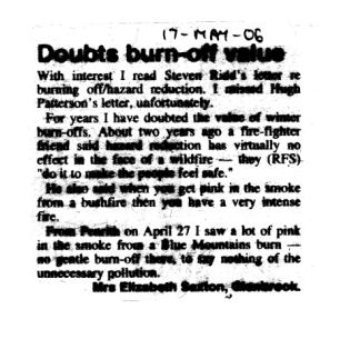