Archive for the ‘Blue Mountains (AU)’ Category
Friday, July 5th, 2013
 Katoomba Golf Club this week has been placed into administration – about time!
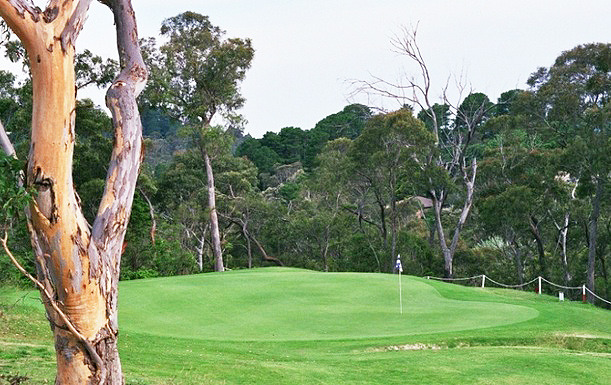
[Photo by Editor, 20130507, Photo © under ^Creative Commons] Katoomba Golf Club this week has been placed into administration – about time!
[Photo by Editor, 20130507, Photo © under ^Creative Commons]
.
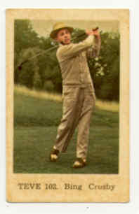
Actor Bing Crosby used to famously play golf back in the 1950s, but in 2013 who plays golf but the last of retired male Baby Boomers? The sport is a ‘has been’ and most courses have been constructed necessitating broadscale habitat destruction, and arrogantly so.
Golf’s origins date back to 15th Century Scotland and to the exclusive pastime of its landed gentry – male gentry, one for Gentlemen Only Ladies Forbidden. Along with croquet and lawn bowls, it dates to a bygone era – up there with duelling, archery practice and pheasant hunting.
This week we learn about the demise of another golf club struggling to attract new members as its 20th Century members ‘pass on’.
In the Blue Mountains west of Sydney, the Katoomba Golf Club as registered body formed just over a hundred years ago back in 1911. The land on which Katoomba Golf Club sited Katoomba Golf Course after the war in May 1923, had few previous owners in historic times.
A brief reflection on relevant colonial history
In the 18th Century, the island continent we now call Australia, was considered ‘undiscovered’ by the then dominant global European powers that be. In 1768, the then head of state of the Kingdom of Great Britain and Ireland, King George III commissioned his Royal Navy to undertake a world expedition voyage under the command of Lieutenant James Cook (combined with Botanist Joseph Banks of the Royal Society) to the south Pacific Ocean aboard HMS Endeavour, which took place between 1768 to 1771. Amongst the voyage’s prescribed tasks were to observe the 1769 transit of Venus across the Sun (3–4 June that year), and to seek evidence of the postulated Terra Australis Incognita or “undiscovered southern land”, plus other exploratory, naturalist and mapping duties.
In April 1770, the voyage famously became the first known European expedition to reach the east coast of Australia, mapping the coastline and making landfall near present-day Point Hicks, and then proceeding north to Botany Bay, naming the land New South Wales.
On 21st August 1770, Cook’s exploration party stepped ashore on an island in the Torres Strait situated 2km off now Cape York Peninsula (since called Possession Island) and declared possession of this “undiscovered southern land” to the British Crown. This was on the basis of unilateral possession – the land perceived as ‘terra nullius’, being Latin for ‘land belonging to no one’, because Cook and Banks considered there were few ‘natives’ along the coast and deduced that there would be fewer or none inland.
Subsequently, the British colonial First Fleet arrived at Botany Bay then Port Jackson in 1788 to establish a British convict settlement was set up in New South Wales.. The Proclamation of NSW Governor Richard Bourke in 1835 implemented the legal principle of terra nullius in Australian law as the basis for British settlement, 47 years later. Such were the powers that prevailed at the time. Various ‘frontier wars’ were waged sporadically between the Aboriginal peoples and the vastly out-weaponed British military and colonists for 46 years (1788-1934). By 1901, Australia was universally declared a unified federated nation state – The Commonwealth of Australia.
This island continent had been ‘legally owned’ (possessed) by the British Crown since Cook’s authorised declaration of possession in 1770. From 1788, the British penal colony of New South Wales was ruled by successive British military governors of the Colony of New South Wales. Until 1824, the military governors of New South Wales were absolute rulers with rights granted to them under an Act of the British Parliament of 1787. The only power superior to them being the British Parliament at Westminster in London, England.
History is history.
So, back to the land of Katoomba Golf Course – obtained historical written records show that the land site was then ‘legally owned’ by the London Chartered Bank of Australia from at least as far back as the 1870s. Katoomba was then not a settlement. Only a sandstone rock quarry ‘The Crushers‘ is historically documented to be in the area to supply ballast for the new railway line roll-out from the 1860s to 1874 when a railway siding was built. It appears that soon afterwards, English migrant (entrepreneurial merchant, miner then property developer) John Britty North acquired vast acreage around the south western area of The Crushers, which would become called the township of Katoomba.
Thus far, our research has not revealed how the local council happened to acquire the land of what would become granted to Katoomba Golf Club in 1920 to deforest the bushland for a golf course. In 1889, Blue Mountains Council did not exist, rather it was one of a number of smaller regional municipal councils across the central Blue Mountains, then it being termed the Katoomba Municipal Council Incorporated).
This is an historic legal document we have obtained that reveals the original deal dated 28th January 1920 between the Katoomba Golf Club and the then local council. At the time the deal was in fact legally between ‘The South Katoomba Land Company Limited‘ and ‘The Council of the Municipally of Katoomba‘. The former was the registered legal body that certain local business owners had established as a legal entity, and the then legally named local council.
 Loading...
Now this is a good revealing read. How’s these stated legal requirements for instance:
-
“Council at its own expense… (read Clause 1), (read Clause 2)”
-
(Clause 3) “THAT the said Council its successors and assign will not at any time erect on the said land any dwelling house or other building except a golf club house or a tennis court or croquet cloub house or a club house for any other purpose for recreation as allowed by paragraph (a) 2 and sheds outhouses stables and other buildings in connection herewith.”
The land was then owned by the then Katoomba Council (i.e. by the local community). The land was acquired from the local council for £1500 by property developers under the name of the South Katoomba Land Company. Was the escarpment land paid for, loaned or gifted? A nearby Gully was acquired a generation later from the Katoomba Council via a £27,000 loan to build a motor racing track, but the loan was never repaid.
So golf playing at the Katoomba Golf Club was in full swing from the 1920’s, and when Bing Crosby was playing during the post War 1950’s, golf was in its heyday. But by the end of the 1980s for reasons of waning interest, other competing interests for a four hour round of golf, busy lifestyles and basic economics; the Baby Boomer golf fad was fading. This was not just across Australia, but across America and elsewhere. Read the article at the end of this one by Nancy Keate, in The Wall Street Journal.

[Source: ‘Is Economy Or Lack Of Interest Hurting Golf?’, 20110523, by Ian Hutchinson ,
^http://www.golfnewsnow.ca/2011/05/23/is-economy-or-lack-of-interest-hurting-golf/]
.
“Over the past week, we’ve been discussing the declining number of golfers, both in Canada and the United States, a topic sparked by this story (see below) by Gene Yasuda of Golfweek.
Of course, the U.S. numbers used by Yasuda were provided by the National Golf Foundation, but here in Canada, we have no recent official numbers to go by, so it could be argued that there’s no cause for alarm about the number of Canadian golfers.
Some might even be tempted to lean on the crutch that Canada is among the world leaders in golfers per capita. Even if that is still the case, it doesn’t necessarily mean that the number of golfer isn’t dwindling.
All golf operators need to do is look out on their fairways and compare the number of golfers out there today to what it was five or 10 years ago to come to a realistic conclusion on how the number of golfers is affecting their businesses and whether it’s up, down or stagnant.
Of course, that number may be affected by the number of golf courses in a saturated market, but the feeling I get from different regions of the country leads me to believe that the number of overall golfers in this country is stagnating at best. If only there were numbers to back that up.
The consensus in the Golfweek story is that the U.S. numbers are affected mainly by the struggling American economy more than a lack of interest in the game.
Here in Canada, however, we’ve come out of the economic downturn a lot quicker that the U.S., but economic factors such as the price of gas and other inflation and the possibility of rising interest rates may be playing a part.
On the other hand, Canadian golf may be feeling the competition from other entertainment and recreation sources, which could indicate a waning interest in the game. While economic pressures on golfers might be a temporary factor, waning interest is more long term.
Which of those two factors do you feel is affecting the number of golfers in Canada? That’s the subject of this week’s GNN Poll.”
U.S. golf participation falls for third consecutive year
May 9, 2011 [SOURCE: http://golfweek.com/news/2011/may/09/us-golf-participation-falls-third-consecutive-year/]
“For the third consecutive year, the number of golfers in the U.S. declined, falling 3.6 percent to 26.1 million in 2010, according to the National Golf Foundation.
The slide, from 27.1 million golfers in 2009, wasn’t unexpected in light of the heavy toll the recession has had on the sport and the economy in general.
The silver lining, if any, according to NGF officials, is that the participation falloff is more linked to financial pressures rather than golf losing popularity among consumers.
“Multiple NGF studies of golfers since 2008 would attribute the gradual decline in golfers and rounds primarily to the impact of lower job security and concern over personal finances, not waning appeal for the game,” said Joe Beditz, NGF president and CEO.
The NGF supported that conclusion by citing golf’s continuing ability to attract “new” participants – in 2010 a total of 3.6 million, including 1.5 million first-time beginners and 2.1 million returning former golfers.
That gain, however, was negated by the loss of 4.6 million golfers who played in 2009 but not in 2010. According to the NGF, the number of new golfers held steady while the number of those who left the game decreased significantly. In recent years, golf industry leaders have been emphasizing improving the retention of golfers.
For all their efforts, though, the downward trend of participation remains a major concern. By comparison, the number of golfers in the U.S. in 2000 and 2005 was 28.8 million and 30 million, respectively.
Among the other findings:
-
-
- The number of “core” golfers (eight or more rounds annually) dropped to 14.8 million – down 3.6 percent from 15.3 million in 2009.
- “Occasional” golfers suffered a similar decline: a drop of 3.7 percent to 11.3 million from 11.8 million in 2009.
- The number of rounds played in 2010 was 475 million, down 2.3 percent from 486 million in the previous year. (By comparison, rounds played in 2000 and 2005 was 518 million and 500 million, respectively.)
The participation study defines a golfer as a person, age 6 or older, who plays at least one round of golf in a given year. Its results are “derived from a multi-sport study of 40,000 Americans, executed in conjunction with the Sporting Goods Manufacturers Association,” the NGF stated.
Yet, despite this general waning interest in golf and despite specifically the falling membership at both Katoomba and nearby Leura golf clubs, some Baby Boomers in complete denial decided in the 1990s to expand the Katoomba golf course from 9 holes to 18. [Editor’s Corrigendum: Correspondence received from an informed reader after publication, has confirmed that the golf course was in fact expanded from 9 holes to 18 holes circa 1927 (^Source). The development works circa 1995 instead relate to expansion of the course acquiring 5.6 hectares of adjoining community zoned woodland alongside Narrow Neck Road in order to build 13 townhouses and a resort hotel. Also circa 2007, a fairway/green was extended into bushland near Stuarts Road.] Further, they had grandiose notions of building a dozen new dedicated golfing townhouses next to the clubhouse, so perpetuating the ‘has-been’ American trend of the 1980s.
Where did the millions in development finance come from and how much was put up by local Blue Mountains Council negotiated behind closed doors claiming a dubious excuse fo commercial in confidence” dealing with this being zoned ‘Community Land‘ ?
Of course, this development necessitated a considerable acquisition of more surrounding bushland to be logged, the vegetation slashed and bulldozed, the soils landscaped, grassed and fertilised. This has meant permanent destruction of the ecosystem just like open cut mining. All this occurred immediately above and upstream of the Jamison Valley wilderness, now part of the Blue Mountains World Heritage Area.
.
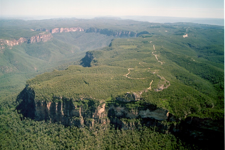
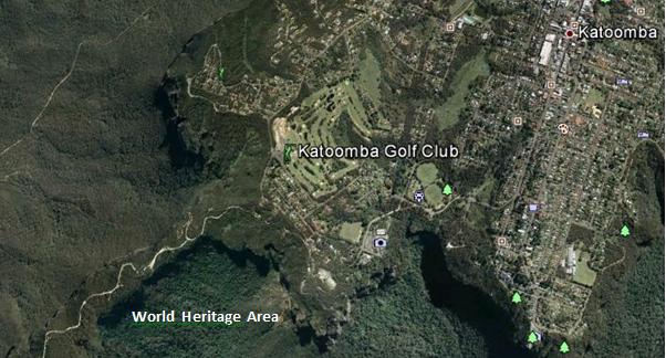 Juxtaposition of the Katoomba Golf Club (light green coloured fairways) replacing virgin habitat across the escarpment; all so that a few retiring Baby Boomer men can selfishly play golf at the expense of Ecology.
[Source: Google Earth, 2013] Juxtaposition of the Katoomba Golf Club (light green coloured fairways) replacing virgin habitat across the escarpment; all so that a few retiring Baby Boomer men can selfishly play golf at the expense of Ecology.
[Source: Google Earth, 2013]
.
During the construction of the additional nine holes [Editor’s Corrigendum: The construction instead related to building 13 townhouses and a resort hotel], the development proposal submitted to the local Blue Mountains Council, specified a new track would be constructed through adjacent bushland to connect two fairways. It was deceptive, because that track became a new wide fairway, complete with soil replacement, landscape contouring, grass seeding and fertilizer.
Repeated instances of sediment run-off from the construction were formally reported to the local Blue Mountains Council by concerned local residents, yet no remediation action was undertaken and no punitive fines were issued.
.
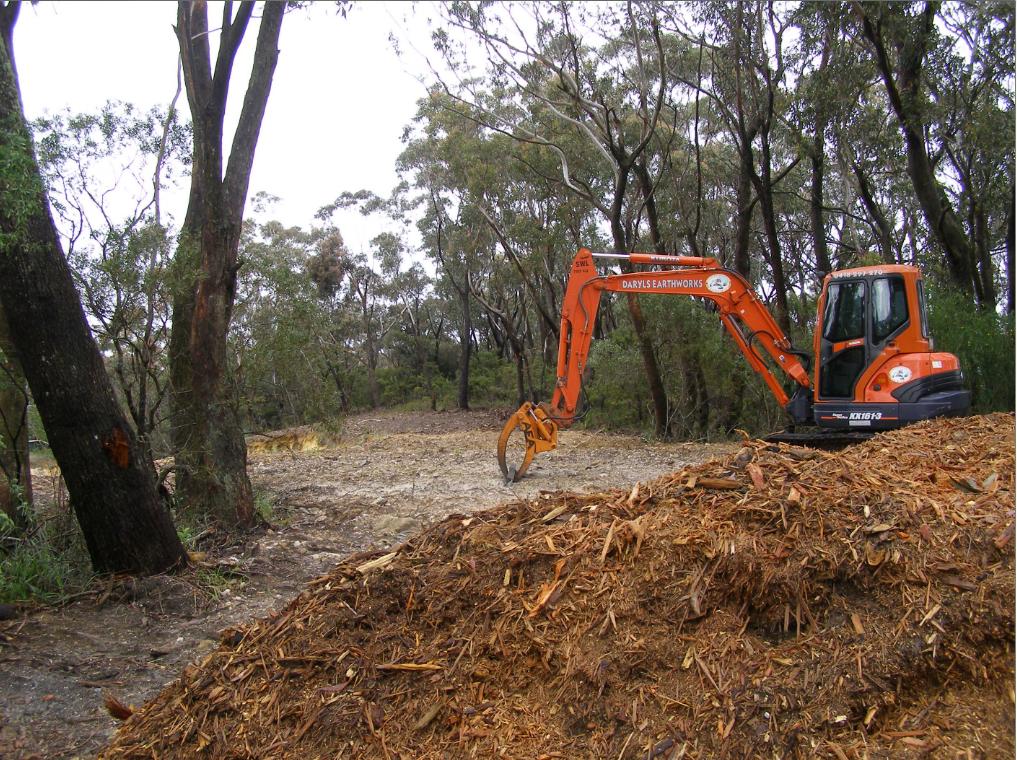 Native bushland along the Blue Mountains escarpment slashed and woodchipped to expand the Katoomba Golf Club out to 18 holes
[Editor’s Corrigendum: The construction instead related to building 13 townhouses and a resort hotel]
[Photo by Editor, 20071110, Photo © under ^Creative Commons] Native bushland along the Blue Mountains escarpment slashed and woodchipped to expand the Katoomba Golf Club out to 18 holes
[Editor’s Corrigendum: The construction instead related to building 13 townhouses and a resort hotel]
[Photo by Editor, 20071110, Photo © under ^Creative Commons]
.
.
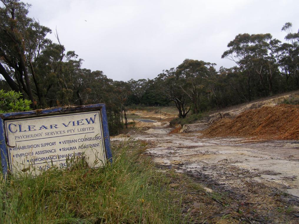 Native bushland bulldozed to make way for golfing townhouses adjacent to the Katoomba Golf Club
Erosion and sediment run-off has been rife for years
[Photo by Editor, 20071110, Photo © under ^Creative Commons]
Native bushland bulldozed to make way for golfing townhouses adjacent to the Katoomba Golf Club
Erosion and sediment run-off has been rife for years
[Photo by Editor, 20071110, Photo © under ^Creative Commons]
.
Golf courses not only necessitate absolute ecological destruction in such places, but the ongoing maintenance of the fairways and greens demands constant fresh water irrigation. Irrigation, as with farming, risks causing saline intrusion into the groundwater.
The keeping of golfing greens green to uphold the lush traditional image, necessitates that golf courses use extensive amounts of chemical fertilizers containing elevated levels of nitrogen (as sulphate of ammonia), potash , sulphur and phosphorus, as well as the application of pesticides and herbicides. All such chemicals are toxic to Australian native vegetation and to aquatic wildlife in the downstream watercourses. Effectively they are environmental pollutants and so next to and upstream of vital World Heritage, use of such chemicals needs to be legally banned.
The local Blue Mountains Council has failed to monitor run-off from the construction activity into the surrounding natural environment. The custodian of the World Heritage Area, National Parks and Wildlife Service, simply isn’t interested.
.
.
 White Elephant golfing townhouses adjacent to the Katoomba Golf Club that have since stood vacant for years
[Photo by Editor, 20071110, Photo © under ^Creative Commons]
.
 << It’s big, blue and beautiful! Blue Mountains National Park is located just 60 kilometres west of Sydney. It is unique in it’s history, its wildlife and world famous scenery…includes the Grose Wilderness, dedicated for its wild unspoilt natural beauty. At Katoomba see the Three Sisters and Katoomba Falls… 300 kilometres of heritage walking tracks and hundreds of lookouts, most within easy reach of a string of train stations. It’s a wilderness made easy to get to! >> << It’s big, blue and beautiful! Blue Mountains National Park is located just 60 kilometres west of Sydney. It is unique in it’s history, its wildlife and world famous scenery…includes the Grose Wilderness, dedicated for its wild unspoilt natural beauty. At Katoomba see the Three Sisters and Katoomba Falls… 300 kilometres of heritage walking tracks and hundreds of lookouts, most within easy reach of a string of train stations. It’s a wilderness made easy to get to! >>
[Source: NSW Government, ^http://www.visitnsw.com/destinations/blue-mountains/katoomba-area/blackheath/attractions/blue-mountains-national-park]
.
[Ed: No mention of golf in the tourism promotion these days]
.
Katoomba Golf Club R.I.P.
.
<<..“the locksmith has been in” and the club is no longer trading.
Unfortunately the club has temporarily closed its doors to the public. They have appointed administrators to handle the business. We are no longer employed. We, the staff thank all of you for your patronage, your friendship, your laughs and your well wishes – it has been a wonderful and memorable time for all of us. A bit of a sad day for us, so thank you. >>
[Source: ‘Katoomba Golf Club shuts its doors’, 20130703, Blue Mountains Gazette, print, p.5, ^http://www.bluemountainsgazette.com.au/story/1614280/katoomba-golf-club-shuts-its-doors/?cs=2062]
.
 Escarpment Karma?
Yet over 50 hectares of vital escarpment habitat has been lost
to a Baby Boomer selfish pastime. Escarpment Karma?
Yet over 50 hectares of vital escarpment habitat has been lost
to a Baby Boomer selfish pastime.
.
Notice of First Meeting of Creditors of Company Under Administration
.
Company: Katoomba Golf Club Ltd
ACN: 000 952 992
Status: Administrators Appointed
Appointed: 01 July 2013
.
Meeting details:
Notice is given that a first meeting of the creditors of the Company, or a first meeting for each of the Companies, (for multiple companies), will be held:
Location: Katoomba Golf Club, Acacia Street, Katoomba New South Wales
Meeting date: 10 July 2013
Meeting time: 12:00PM
.
[Source: ASIC Insolvency Notices].
.
.
‘Fore Sale – Luxury golf communities have hit a rough patch’
[Source: ‘Fore Sale – Luxury golf communities have hit a rough patch’, 20120724, by Nancy Keate, The Wall Street Journal, ^http://online.wsj.com/article/SB10001424052702303703004577474563368632088.html]
.
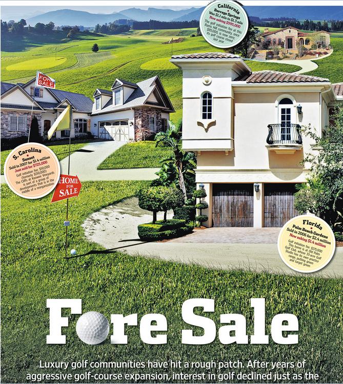 Photo Illustration: Jeff Huang
.
<< After years of aggressive golf course expansion, interest in golf declined just as the market for luxury homes plunged. Now, once-pricey real estate is available at below-par prices. Selling a lot for $1.
Debbie Bowers and her husband, tired of life in their cold Ohio town, spent eight years looking for a home near a sunny luxury golf course in a Southern state. Everything they saw was too expensive. Then this past May, they got a call: A lot was available at South Carolina’s Colleton River Plantation, one of the country’s premiere golf communities—for free.
Prices at luxury private golf communities are crashing, done in by rampant overdevelopment, the economic downturn and waning national interest in the sport. Nancy Keates has details on Lunch Break.
The seller was even willing to pay the $15,000 club initiation fee and the first year of $17,000 annual membership dues at Colleton River, which includes three celebrity-designed courses (two by Jack Nicklaus, one by Pete Dye), a Stan Smith-designed tennis center and a new 6,000-square-foot fitness center. Mrs. Bowers, 55, met her husband that day at the site and signed the papers. They’re now building a 3,000-square-foot house that should be finished by November.
The past two decades saw an unprecedented boom in the building of high-end golf courses linked to luxury real-estate communities. Betting that aging Baby Boomers would embrace golf as their pastime of choice, the National Golf Foundation set a goal of building “A Course a Day” beginning in 1988. Real-estate developers teamed up with top-name golf-course architects, building exclusive communities adjacent to courses, and requiring homeowners to pay annual club dues—sometimes even if they didn’t play. Then, in a moment of spectacularly bad timing, both the golf industry and the real-estate market took a nose-dive at once.
Now, private golf communities are dealing with the fallout. Many sellers are dropping their prices radically, in some cases even paying people to take their land. Gated communities that once traded on their exclusivity are aiming to appeal to a wider swath of buyers, building family-friendly “village centers” with ice cream shops, hiking trails and bowling alleys. A few are even “repurposing” by reducing courses to nine holes from 18 and selling off the reclaimed land.
At golf communities near Bluffton, S.C., like Belfair Plantation, Colleton River Plantation and Berkeley Hall, several lots that initially sold for at least $150,000 are now on sale for $1 apiece. Investors who bought but never built on the sites are trying to unburden themselves of the thousands of dollars—typically $12,000 to $17,000—they still have to pay in annual club dues.
At the Mizner Country Club in Delray Beach, Fla., which has an Arnold Palmer golf course, a lakefront home with five bedrooms, a pool and a spa is asking $795,000. It sold for $1.6 million in 2007. A lot in Horseshoe Bay Resort, near Austin, Texas, that sold previously for $300,000, is on sale for $39,000.
In Bend, Ore., interior designer Ronda Fitton and her husband paid $500,000 for a lot at Pronghorn, a gated community with golf courses designed by Tom Fazio and Jack Nicklaus, in 2006. A similar-size lot sold for $10,000 earlier this year. Ms. Fitton is hopeful values will go up but she says the lot is “worth nothing now. It’s a real bummer.” (Lot prices exclude membership fees.) Lots at Rams Hill in Borrego Springs, Calif. are also selling for about $10,000, compared with $100,000 at the peak.
The housing downturn is partly responsible. But the crash in value has been exacerbated by a development binge that resulted in too many courses just as the sport of golf began to fade in popularity.
From 1990 to 2003, some 3,000 new courses were built in the U.S., swelling the total number of courses nationally by 19% and costing about $20 billion, according to the National Golf Foundation.
Many of these new courses were inextricably linked to the luxury-real-estate market. About 40% of the courses built during the 1990s were tied to real-estate communities—a shift from the previous decades, when that number was closer to 18% and the vast majority of golf courses didn’t have people living on them. The golf courses were the lure to get people to buy houses: The bigger the name of the architect who designed them, the greater the prestige and the more expensive the real estate.
Soon after, however, the sport started to lose its allure. The percentage of the overall population in the U.S. that plays golf is down over the past 10 years, from 11.1% in 2000 to 9.2% in 2010, according to the National Golf Foundation.
Last year the number of rounds played in the U.S. dropped to 463 million from 518 million in 2000. The number of golfers fell to 25.7 million in 2011 from 28.8 million in 2000. A net of more than 350 golf courses have been closed since 2005. In 2011, more than 150 courses closed, outpacing the 19 courses that debuted last year.
Compounding the problem: Real-estate developers didn’t think about the viability of the golf courses themselves, says Art West, founder of Golf Course Advisors, a golf-course consulting company. Many of these courses designed by brand-name golf-course architects were championship-level, too difficult for the average player. They took a long time to play and cost millions a year to maintain, pushing up annual dues.
“It was a perfect storm,” says David Hueber, former president and CEO of the National Golf Foundation, who wrote a paper called ” ‘Code Blue’ for U.S. Golf Course Real Estate Development” stemming from research for his Ph.D. in real-estate development at Clemson University.
Across the country, about 2,000 of the 16,000 golf courses are “financially distressed,” according to the National Golf Foundation. Mr. Hueber estimates that 4,000 to 5,000 golf courses will be in financial danger if they don’t change their model.
Membership fees for many clubs have tumbled. The initiation fee at Old Palm Golf Club in Palm Beach Gardens, Fla., which was as high as $250,000 in 2007, is now down to $175,000, while the fee at Tiburon Golf Club in Naples, Fla., is now at $50,000, compared with $145,000 at its peak.
In some parts of the country, the premium that home buyers are willing to pay for a house on a golf course versus a house that isn’t on a course has dropped to about 25%, from 50% in 2007, says Doug Schwartz, who runs the sales, marketing and homebuilding operations for WCI Communities, in Bonita Springs, Fla., which currently owns four golf communities. Lisa Treu, an agent with the Treu Group in Palm Beach County, says homes on golf courses in Southeast Florida could at one time command a 25% premium over non-golf-course homes; that premium has now dropped to about 10%, she says. (Some areas are still strong, like Palm Springs, Calif., where agents say the premiums are as much as 35%).
“There are a lot of people who would like to get out of here because of the economy,” says Don Davis, who with his wife bought a house in South Carolina’s Colleton River for $970,000 in 2001. The couple, who have loved living in the community but want to move back to Atlanta to be closer to their grandchildren, say it doesn’t make financial sense to move without selling their house because they’d still have to pay the community’s annual membership dues of some $17,000. Their house, listed at $775,000, hasn’t had any offers in its six months on the market.
Real-estate agent Dick Datz of Carolina Realty Group says Belfair and Colleton River are offering agents a $5,000 bonus when they sell a $1 lot; otherwise the commission would be pennies. Rob Norton, president of the Colleton River Plantation Board, says houses in the community are selling and there’s lots of new construction. It’s mostly the people who bought the land as an investment who are having a hard time, he says.
Some developers are recasting their golf communities to appeal to a broader swath of home buyers, including more families and young people. One example: Tuscany Reserve, a 450-plus-acre private golf community in Naples, Fla., which had about $200 million invested in its infrastructure, including a golf course designed by Pete Dye and Greg Norman, before it went bankrupt. Florida developer Syd Kitson recently bought the community for $30 million and changed the name to Talis Park, which he thought sounded more youthful. Instead of building a clubhouse as planned, Mr. Kitson, will build a “village center” with a cafe, a spa and walking paths. Homes are now expected to be in the $700,000-to-$2 million range instead of up to $6 million, as originally intended.
“The model of a country club in its current form is gone forever,” says Mr. Kitson.
After seeing sharp decreases in its sale prices, Pronghorn, the gated community in Bend, Ore., opened its gates, launching a 48-suite lodge in 2010 and inviting the public to use one of its two golf courses. The Resort Group, a resort operator based in Honolulu, Hawaii, took over in February and announced it will bring in Auberge Resorts to manage the property, turning it into a five-star resort with a spa, three restaurants, two pools, tennis courts and a kids club.
The Cliffs—a group of eight residential developments spread among 20,000 acres between Greenville, S.C., and Asheville, N.C., with golf courses designed by Jack Nicklaus and Tom Fazio—filed for U.S. Bankruptcy Court protection in February, with estimated liabilities between $100 million and $500 million. A planned golf course for the Cliffs, designed by Tiger Woods, hasn’t been started. According to a 2007 news release, the Cliffs sold 40 lots in the $500,000 price range, and lots at that time couldn’t be purchased below $200,000. Earlier this year a lot sold in one high-end community for less than $10,000, according to real-estate agent Justin Winter.
Owners at the Cliffs, who tried to bail it out earlier by putting up $64 million to keep the club operating, say they are optimistic and are in the midst of a reorganization with Carlile Group, a diversified company based in Marshall, Texas. Carlile is working with two other groups.
Owners say the revamped club will have more options for membership. The initiation fee, which was $150,000, is now $50,000. “We are working diligently to find and deliver the best solution for all members and property owners at the Cliffs,” Steve Carlile of Carlile Group says in a statement.
Golf-course architect Bobby Weed of Bobby Weed Golf Design has been helping residential golf communities over the past few years “repurpose”—by compressing the properties. He is currently working on several proposals to shrink 18-hole courses to nine holes. At the Deltona Club in Deltona, Fla., he helped reduce the amount of land used by the clubhouse and the golf course to create a separate, 17-acre parcel for development.
The steep decline in prices is a boon for potential buyers, of course. “Now I’m getting worried I’m going to miss out if I don’t move quickly,” says Gordon Flach, 44, who has been looking for a golf resort home in Montana, Utah or Oregon for the past three years. Mr. Flach, who is part owner of a resort in the Bahamas, has his eye on a $425,000, 3,800-square-foot four-bedroom house in Pronghorn. A similar house was going for $1.1 million when he first started looking.
Ron Ruff, a 55-year-old semiretired anesthesiologist, got his lot at Pronghorn free about a year ago. The seller also kicked in part of the $115,000 reimbursement of his golf-club membership initiation fee he got back when he “sold” the land. Mr. Ruff says that he felt, despite the dire climate and other people thinking he was crazy, that Pronghorn has a “magical” feel and that the value would be realized again, just as he had seen happen in other areas before. His house is now complete.
John Reed, the original developer of Colleton River Plantation, Belfair Plantation and Berkeley Hall, concedes there are too many golf-course communities. “There’s a train wreck in the industry now,” he says. “We overbuilt and the market stopped.” He had Pete Dye and Tom Fazio design a golf course for his latest development, called Hampton Lakes, but decided to nix it in favor of a 165-acre freshwater fishing and boating lake.
“The best golf course we ever did is 9 feet underwater,” he jokes. >>
.
Tags: baby boomer, Blue Mountains Council, Blue Mountains Escarpment, Blue Mountains World Heritage Area, BMCC, broadscale habitat destruction, chemical fertilizers, Community Land, eco-rapist sport, escarpment slashed, golf, golf course development, golfing townhouses, institutionalised sport, irrigation, Jamison Valley Wilderness, Katoomba Golf Club, run-off, The Escarpments
Posted in Blue Mountains (AU), Threats from Development, Threats from Selling Public Land, Threats from Tourism and Recreation | 8 Comments »
Add this post to Del.icio.us - Digg
Saturday, June 22nd, 2013
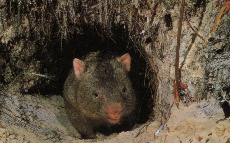
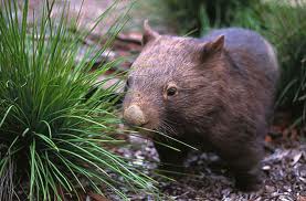
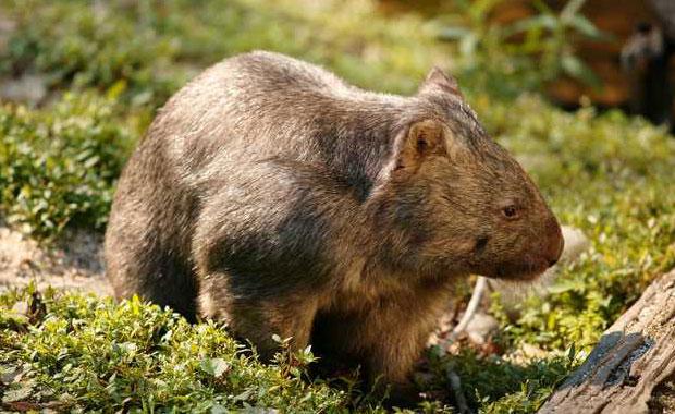 Common Wombat
(Vombatus ursinus)
A legally protected native animal throughout Australia
[Source: Healesville Sanctuary, Victoria, Zoos Victoria,
^http://www.zoo.org.au/healesville/animals/wombat] Common Wombat
(Vombatus ursinus)
A legally protected native animal throughout Australia
[Source: Healesville Sanctuary, Victoria, Zoos Victoria,
^http://www.zoo.org.au/healesville/animals/wombat]
.
June 2013:
.
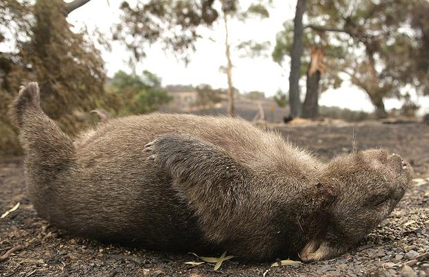
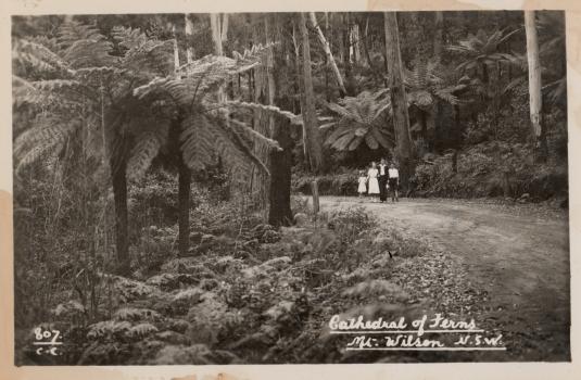
Tragically, a native Wombat has been deliberately poisoned this month in Mount Wilson in the Blue Mountains, and so the New South Wales National Parks and Wildlife Service (NPWS) is appealing for information from the local community.
Ranger Neil Stone of the NPWS Blue Mountains Region:
“A Wombat was recently found at Mount Wilson village (population 220), suffering from what a local veterinarian thinks was poisoning and sadly the animal had to be euthanized.
“Wombats become unpopular with landholders when they damage fences and infrastructure or trample on gardens. But there are methods, including installing Wombat Gates, that enable Wombats to pass through properties without damaging them.”
.
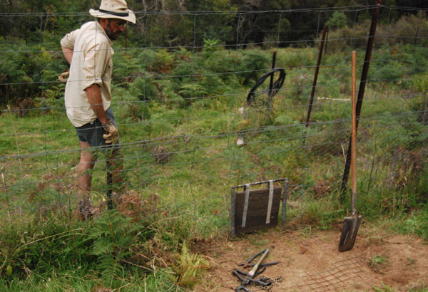 An example of a purpose-built Wombat Gate
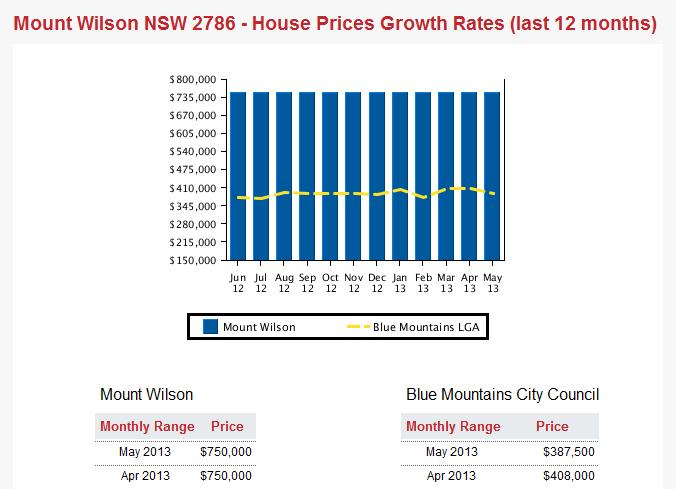
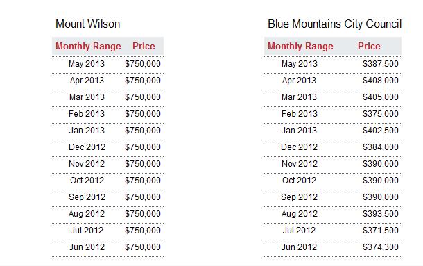
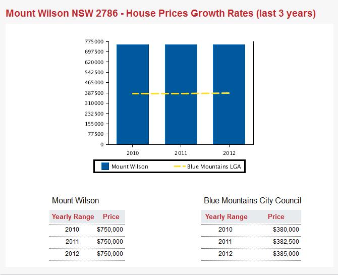
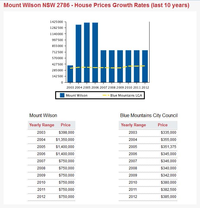
If one can afford property at exclusive Mount Wilson with average prices currently $750,000 [^Source]
then one can afford to contribute a few purpose-built Wombat Gates across their property,
constructed by wildlife experts who know what they are doing!
[Photo Source: Rocklily Wildlife Refuge, Taralga, NSW,
^ http://rocklilywombats.com/blog/rocklily-history/] An example of a purpose-built Wombat Gate
If one can afford property at exclusive Mount Wilson with average prices currently $750,000 [^Source]
then one can afford to contribute a few purpose-built Wombat Gates across their property,
constructed by wildlife experts who know what they are doing!
[Photo Source: Rocklily Wildlife Refuge, Taralga, NSW,
^ http://rocklilywombats.com/blog/rocklily-history/]
.
NPWS Ranger Neil Stone:
“Wombats are extremely strong and determined, constructing their burrows (often under homes) to escape from the heat and to hide from predators (typically domestic and feral dogs nowadays). The burrows can be up to 30 metres long which can cause conflict between Wombats and humans.”
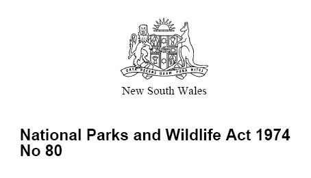
“Wombats and all other native animals are protected under the National Parks and Wildlife Act 1974 and Regulations and it is illegal to harm them without a licence. There are fines and possible imprisonment for people found to have intentionally harmed native wildlife.”
.
[Source: ‘Not so divine: Wombat dies in suspected poisoning’, 20130612, Blue Mountains Gazette newspaper (print only), p.15]
.
Wildlife Poisoning is Animal Harm
.
Wombats being mammals are sentient animals, meaning that they feel emotion and pain. An animal is ‘sentient‘ if it is capable of being aware of its surroundings, its relationships with other animals and humans, and of sensations in its own body, including pain, hunger, heat or cold.
Individuals who harm animals including the harming of wildlife such as by poisoning, tend to harbour a personality disorder. Statistically, animal abusers are five times more likely to go on to commit violent crimes against people.
Deviant behaviors like animal abuse generally originate from a traumatic childhood. The American Psychiatric Association considers animal cruelty as one of the diagnostic criteria of conduct disorder.
The fourth edition of the Diagnostic and Statistical Manual of Mental Disorders (DSM) defines conduct disorder as “a repetitive and persistent pattern of behavior in which the basic rights of others or major age appropriate societal norms or rules are violated.” Conduct disorder is found in those who abuse animals and abuse people.
Clinical evidence indicates that animal cruelty is one of the symptoms usually seen at the earliest stages of conduct disorder, often by the age of eight. This information has only recently been included in the DSM so some psychologists, psychiatrists, and social workers are just now becoming aware of it. Many psychological, sociological and criminology studies in recent decades have clearly shown that violent offenders have adolescent histories of serious and repeated animal cruelty.
Director of People for the Ethical Treatment of Animals (PETA) Asia, Jason Baker, has said, “We believe that cruelty to animals is not inherent, but learned. That being said, teaching kindness and respect for animals – in our schools and homes – will foster empathy, the ability to understand what someone else feels.” He added, “Incorporating the simple concepts of kindness and respect into our daily lives and teaching our children to respect and protect even the smallest and most despised among us will help kids value one another.”
The link between animal abuse and interpersonal violence is becoming so well established that many U.S. communities now cross-train social-service and animal-control agencies in how to recognize signs of animal abuse as possible indicators of other abusive behaviors. >>
.
[Source: ‘Animal Cruelty Syndrome’, by Canadians for Animal Welfare Reform, ^http://cfawr.org/animal-abuse.php]
.
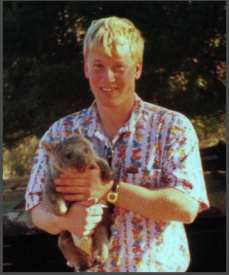 Martin Bryant as a teenager nursing a juvenile Wombat
Bryant reportedly tortured animals as a child.
In 1996, at age 29 Bryant murdered 35 people and injured 21 others
at Port Arthur Tasmania Martin Bryant as a teenager nursing a juvenile Wombat
Bryant reportedly tortured animals as a child.
In 1996, at age 29 Bryant murdered 35 people and injured 21 others
at Port Arthur Tasmania
.
Penalties in NSW for Harming protected Fauna
.
.
Sect 98 ‘Harming protected fauna, other than threatened species, endangered populations or endangered ecological communities’
.
(Ed: i.e. Wombats)
.
(1) In this section, protected fauna does not include threatened interstate fauna, threatened species, endangered populations, endangered ecological communities, or locally unprotected fauna under section 96.
(2) A person shall not:
(a) harm any protected fauna, or (a1) harm for sporting or recreational purposes game birds that are locally unprotected fauna, or
(b) use any substance, animal, firearm, explosive, net, trap, hunting device or instrument or means whatever for the purpose of harming any protected fauna.
.
Maximum penalty:
.
(a) 100 penalty units and, in a case where protected fauna is harmed an additional 10 penalty units in respect of each animal that is harmed, or
(b) imprisonment for 6 months, or both. >>
.
Note: As at 2013, 1 penalty unit in NSW equates to $110. So 100 +10 penalty units incurs a fine of $12,100 per protected Wombat harmed [Calculation: (100 + 10) x $110]
.
[Sources: National Parks and Wildlife Act 1974, No 80, Section 98, (historical version but this section still current), pp 149-150, ^http://www.environment.nsw.gov.au/legislation/NationalParksAndWildlifeAct1974.htm ; ^http://en.wikipedia.org/wiki/Penalty_units]
.
.
.
So who killed the Mt Wilson Wombat?
.
 A common Wombat sight
…”Just Roadkill”
A common Wombat sight
…”Just Roadkill”
.
It is likely that Mount Wilson’s Wombat was poisoned by an ignorant and frustrated local landholder. He is one of just a few hundred residents living at remote Mount Wilson village, and probably he is some arrogant newcomer with no respect for the natural environment or its resident wildlife who were there first. It is extremely rare for a female to commit wildlife poisoning.
The perpetrator is likely to be someone holding an Anglicised mindset toward rural property, desiring the exotic deciduous garden and with a phobia towards the natural Australian bush. Whereas the more established residents tend to be respectful towards the special environment in which they live and have become more accommodating towards the place’s resident wildlife.
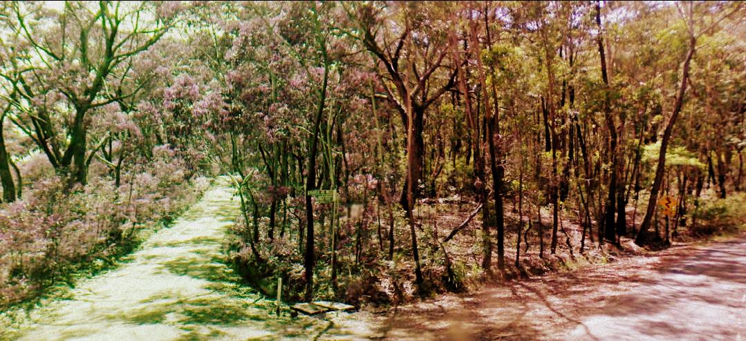
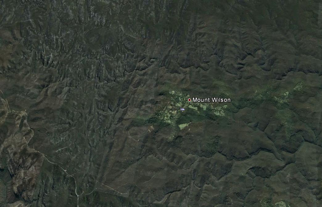 Mount Wilson lies in a remote forested wilderness region of the Blue Mountains
And the native Wombats have lived there thousands of years before
Colonial Deforestation
Housing Development
Anglicised Garden Romanticism
[Source: Google Earth]
(click image to enlarge) Mount Wilson lies in a remote forested wilderness region of the Blue Mountains
And the native Wombats have lived there thousands of years before
Colonial Deforestation
Housing Development
Anglicised Garden Romanticism
[Source: Google Earth]
(click image to enlarge)
.
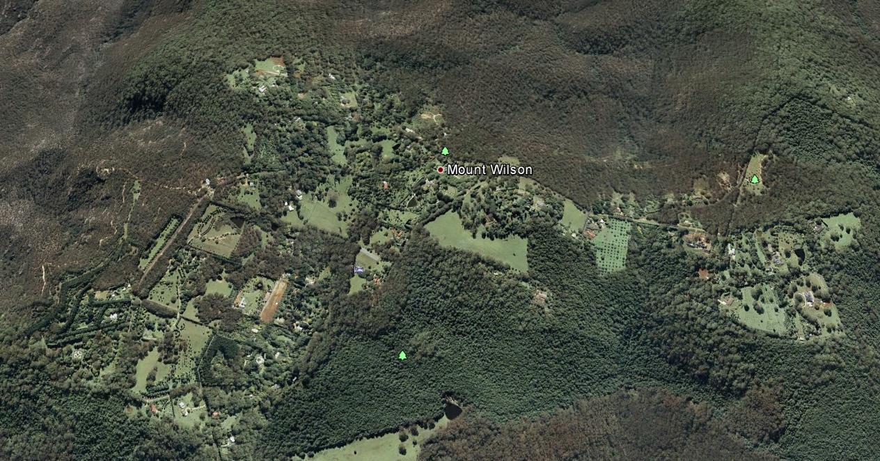 Mount Wilson
Best described as a remote hilltop residential hamlet
Situated on an ancient volcanic hill
Since the 1870s, logged, burned and settled by English colonists
amongst the ‘Wombat Holes’
[Source: Google Earth]
(click image to enlarge)
Mount Wilson
Best described as a remote hilltop residential hamlet
Situated on an ancient volcanic hill
Since the 1870s, logged, burned and settled by English colonists
amongst the ‘Wombat Holes’
[Source: Google Earth]
(click image to enlarge)
.
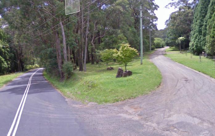 Hillcrest Lane (right), Mount Wilson Hillcrest Lane (right), Mount Wilson
[Source: Google Maps, 2013]
.
 Mount Wilson before the Anglicising
[Source: Mt Wilson/Mt Irvine Historical Society, ^http://www.mtwilson.com.au/]
Mount Wilson before the Anglicising
[Source: Mt Wilson/Mt Irvine Historical Society, ^http://www.mtwilson.com.au/]
.
Consistent with the profile of the typical member of the Game Council NSW, the perpetrator is likely to be a middle-aged or older male Babyboomer approaching 65, having an anthropocentric worldview of Nature, and an evangelistic belief that economic growth and personal wealth accumulation is a right – Wombats being collateral damage in rural housing development.
 Mount Wilson bushland
.
The perpetrator has not yet been confirmed, and anyone with information about this harmful offence is asked to contact the closest NPWS base at the Blue Mountains Heritage Centre in nearby Blackheath.
.
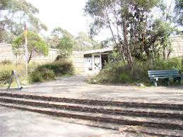 NPWS Blue Mountains Heritage Centre
Located towards the eastern end of Govetts Leap Road
outside the nearby township of Blackheath NPWS Blue Mountains Heritage Centre
Located towards the eastern end of Govetts Leap Road
outside the nearby township of Blackheath
.
.
.
The ‘Common‘ Wombat?
.
The Common Wombat (Vombatus ursinus) is also known as the Coarse-Haired Wombat or Bare-Nosed Wombat. In the case of the Bare-Nosed Wombat, this reference to its nose, distinguishes it from its other two subspecies, the Southern Hairy-Nosed Wombat (Lasiorhinus latifrons) and the endangered Northern Hairy-Nosed Wombat (Lasiorhinus krefftii).
The ‘Common Wombat‘ is a nocturnal marsupial native to south eastern Australia and is found in small sections of southeast tip of Queensland, eastern New South Wales, eastern and southern Victoria, and south-east South Australia. They are common throughout Tasmania and also on Flinders Island in Bass Strait.

The head of the Common Wombat is more rounded than that of the hairy-nosed subspecies. Their short ears are triangular and slightly rounded. Their nose is large, shiny black and furless. Their fur is coarser, thicker and longer than that of the Hairy-nosed Wombats, better suited to a colder, wetter habitat. Fur colour varies from sandy to brownish black or even grey, sometimes flecked.
.
 Bare-Nosed Wombat
a more respectful naming than ‘Common’ Bare-Nosed Wombat
a more respectful naming than ‘Common’
.
Wombats have short legs, and the second and third toes of the hind feet are fused, with a double claw used in grooming. Wombats are solid and stocky, with short legs and tail. Their front legs and shoulders are powerful. Their front feet are large, with bear-like long claws. They use their front legs for digging burrows. The dirt is pushed to one side and the Wombat backs out, moving loose dirt with front or back paws. It grows to an average of 98 cm long and up to a healthy weight of 26 kg.
Wombats are stilll classed as ‘least concern’ by the International Union for Conservation of Nature and Natural Resources (on the IUCN ‘red list’). [Ed: So were the Koala and Tasmanian Devil until recently].
At Healesville Sanctuary in Victoria, more than 2,000 sick and injured native animals treated each year including Wombats at its Australian Wildlife Health Centre.
[Source: Healesville Sanctuary, Zoos Victoria, Victorian State Government, ^http://www.zoo.org.au/healesville/animals/wombat]
.
 Situated on Badgers Creek
A place of inspiration to this Editor,
when visited as a child. Situated on Badgers Creek
A place of inspiration to this Editor,
when visited as a child.
.
Although Wombats have been named by European Australians as the ‘Common Wombat‘, their numbers and their existence value does not translate to anyone treating them as commonplace.
Common Wombats were once widespread from south-eastern Queensland, through NSW along the Great Dividing Range and most of Victoria. Now they have a fragmented distribution in NSW, being most abundant in the south-eastern parts of the state. Remaining populations are under continued pressure from land clearing, road mortality, disease and illegal shooting. These pressures may be acute for some local populations.
While the word ‘Wombat’ is derived from the Aboriginal name for the animal, ‘common’ was added at a time when these animals were plentiful and the Australian bush landscape relatively less destroyed by colonial settlement. Wombats were likened to European Badgers by the early colonists.
We prefer the more respectful name, ‘Bare-Nosed Wombat‘.
.
In 2010, university student Nikki Selles, from the School of Natural Sciences at the University of Western Sydney, undertook a field fauna study on Wombats in the Mt Wilson and Mt Irvine area. Due to the behaviour of slow moving, ground-dwelling Wombats being sensibly shy and noctural, Selles used camera-trap data to identify their habitat and distribution in the urban-bush interface.
Results ought to be obtainable from the university.
[Source: Mount Wilson and Community Newsletter, May 2010, ^http://www.mtwilson.com.au/images/stories/MWPA_Newsletters/May_2010.pdf]
.
While the Bare-Nosed Wombat is not yet threatened with extinction, the Northern Hairy-Nosed Wombat is endangered. This is mainly due to overgrazing by sheep and cattle destorying their fragile semi-arid habitat across more central Australia, as well as the culture of broadscale hazard reduction and uncontrolled bushfires.
Mount Wilson also provides vital native habitat for fauna species that are recognised as endangered. These include the Sooty Owl (Tyto tenebricosa), the Eastern Bent Wing Bat (Miniopterus schreibersii oceanensis), the Large eared pied bat (Chalinolobus dwyeri), Little John’s Tree Frog (Litoria littlejohni), and the Eastern False Pipistrelle (Falsistrellus tasmaniensis).
.
Living with Resident Wombats
.
 Wombats are locally territorial, like Humans
Try to relocate them, and they will stubbornly resist – even after repeated flood, drought, bushfire and earthquake
Ask any Human who has endured such tempest. Wombats are locally territorial, like Humans
Try to relocate them, and they will stubbornly resist – even after repeated flood, drought, bushfire and earthquake
Ask any Human who has endured such tempest.
.
<<Wombats are an iconic part of the protected fauna of NSW. They are extremely strong and determined animals.
They can build their burrows under Human-introduced houses, driveways and cattle stock routes. This may cause Humans inconvenience and conflict between Wombats and non-Indigenous Humans.
.
But Newcomer Humans need to respect that Wombats were there first.
Who likes Invasion or Displacement?
.
Human-Wombat conflicts can be respectfully resolved and accommodated by wisdom – by learning about the behaviour of Wombats and understanding their habitat needs.
The Bare-Nosed Wombat is the species most frequently found in NSW. They prefer temperate forested areas of the coast, ranges and western slopes. Slopes above creeks and gullies are favoured sites for burrows and they like to feed in grassy clearings, including farm paddocks.
.
Wombat Habitat Needs
.
Wombats construct burrows to escape the heat and hide from predators. They prefer areas where it is easy for them to dig. The burrows can be up to 30 metres long and several metres deep and are usually situated above creeks and gullies and may have multiple entrances. Active burrows are often characterised by fresh cube-shaped droppings and scratch marks as well as freshly dug soil at the burrow entrance. Wombats will often build more than one burrow within their home range of 5 to 25 hectares.
Wombats are mostly solitary animals, but overlapping home ranges can occasionally result in a number of Wombats using the same burrow. Wombats are possessive about their particular feeding grounds and they will mark out these areas by leaving scent trails and droppings. These markings are prominently placed on rocks and logs around the boundaries. If an intruding Wombat encroaches on another’s territory it will be discouraged through a series of snorts and screeches and at times physical aggression.
Breeding occurs year-round with each female typically producing one young. In some areas, however, Wombats are seasonal breeders and may have dependent young in burrows from April to June. Young Wombats take up to 21 months to reach full independence and two years to become sexually mature.
.
Wombat Behaviour
.
Wombats become unpopular with landholders when they damage fences and infrastructure or trample upon gardens. Undetected burrows can be a hazard to livestock as they may trip or fall into burrows and injure themselves.
Many of the problems caused by Wombats can be resolved with some patience and innovation. Landholders willing to share their property with Wombats may find that there are simple solutions to most problems. For example, a post or small strand fence can be used to mark burrows in paddocks or driveways to keep stock away from burrow entrances.
Wombats use the same trails to get to and from their preferred feeding areas. Instead of going around an obstacle, such as a fence, a determined Wombat will try to go through, or under it instead. Installing purpose-built ‘Wombat Gates’ at known Wombat breech points along a fence will allow them to pass through a fence without damaging it. The fence needs to continue to exclude other animals such as wallabies, rabbits and foxes.
Removing the lowest fencing wire (15 cm above ground level) will also allow Wombats to move through an area without damaging the fence. This is a much cheaper option than excluding them completely.
Check first with a Certified National Parks Wildlife Ranger.
.
Excluding wombats from Rural Property
.
It is possible to exclude Wombats from continuing to use a burrow that is under a building but this requires intervention by a Certified National Parks Wildlife Ranger.
.
Increasing Native Vegetation
.
Wombats prefer to burrow in areas of vegetation and rocky debris. Land clearing has forced Wombats to build burrows along creeks and drainage lines where vegetation still exists. Wombats are also often incorrectly blamed for causing erosion, which is more likely due to poor land management practices.
Planting trees and revegetating areas away from creeks can play a vital role in reducing Wombat burrowing activity along creek beds. Retaining existing trees, logs and rocks, and establishing new areas of native vegetation encourages Wombats to construct burrows in less fragile areas and reduces the risk of erosion.
Check first with a Certified National Parks Wildlife Ranger.
.
Trapping or Relocating Wombats Prohibited
.
The trapping and relocation of Wombats is prohibited and attracts heavy fines.
Wombats are territorial animals and if relocated, they are likely to be harassed or even killed by resident Wombats. Wombats are classified as protected fauna under the NSW National Parks and Wildlife Act 1974.
.
Can I bulldoze or infill a Wombat burrow?
.
No! Only inactive Wombat burrows may be destroyed, but each one needs to be first validated by a Certified National Parks Wildlife Ranger.
Bulldozing an active burrow can lead to wombats being buried alive and suffering a slow and painful death. Even if you have located an apparently vacant burrow, you must not fill it in without confirming that it is inactive. Burrow activity can be confirmed by placing sticks across each entrance and checking (every day for at least a week) if these are disturbed.
Remember that if you think you have an inactive burrow, check first with a Certified National Parks Wildlife Ranger.
contact your local National Parks office for expert verification before any action.
.
[Source: NSW Government, ^ http://www.environment.nsw.gov.au/animals/LivingWithWombats.htm#gate]
.
.
.
Further Reading
.
[1] Wombat Gate Design
^http://www.dpiw.tas.gov.au/inter.nsf/Attachments/LBUN-84H7FT/$FILE/Wombat%20gate%20design.pdf
.
[2] Guide to Living with Wombats
[Source: ^ http://www.naturalresources.sa.gov.au/samurraydarlingbasin/plants-animals/native-plants-and-animals/native-animals]
.
[3] National Parks and Wildlife Act (NSW) 1974
^http://www.austlii.edu.au/au/legis/nsw/consol_act/npawa1974247/
.
[4] Wombat Protection Society of Australia
^http://www.wombatprotection.org.au/
.
Why Do Wombats Need Protection?
Lack of Legislative Protection/Enforcement!
<< In Australia native animals are “the property of the Crown”. This means that no-one owns wombats, they can’t be kept as pets and to do anything with them you have to be licensed by government departments.
Government Departments do little to protect or help wombats. Most research and all welfare (rescuing injured wombats, raising the joeys of mothers killed in collisions with vehicles, removing wombats from unsuitable places) is undertaken by voluntary organizations. While penalties exist if someone is found to hurt or kill a wombat, the same government departments charged with wombat care issue permits to farmers to cull wombats. Sadly, there is often no check whether this is necessary, whether it is done humanely or any insistence that alternative options be employed before issuing such permits.
On the other hand although penalties exist for the illegal killing of wombats, such killing occurs every night where on a farms they are shot, buried alive and gassed and on the highways of Australia vehicles indiscriminately drive directly at wombats without penalty. Live joeys left in their dead mother’s pouches die slowly and a lack of public education means few Australians understand how to rescue a joey still living after its mother falls victim to road kill. >>
.
 The Crown
Disinterested in protecting Australian wildlife
The kangaroo and emu images are but token symbolism The Crown
Disinterested in protecting Australian wildlife
The kangaroo and emu images are but token symbolism
.
[5] The Wombat Foundation
^http://www.wombatfoundation.com.au/
.
<<The Wombat Foundation is a charitable organisation set up to support activities that aim to bring the Northern Hairy-nosed Wombat back from the brink of extinction.
The Northern Hairy-nosed Wombat is one of the world’s most endangered species – it is more endangered that the Panda.
In the 1980s, there were as few as 35 wombats remaining on the planet – all at Epping Forest National Park in central Queensland. A second population was established at Richard Underwood Nature Refuge in southern Queensland in 2009. At last count, in 2010, there were a total of 176 wombats across the two sites. Since then, the population has continued to grow: in 2012, the combined population at the two sites was estimated at 200 wombats. >>
.
[6] Wombat Awareness Organisation
^http://wombatawareness.com/
.
<<We are a charity established to help save the Southern Hairy-nosed Wombat (Lasiorhinus latifrons) from extinction.
The wombat is an Aussie icon but few people are aware of the peril these gorgeous little animals face: drought, floods, climate change, disease, vehicular incidents and culling – both legal and illegal. It’s not rocket science to see these animals are in trouble but thanks to the work of WAO volunteers, there is hope!
Currently, the wombats are being affected by an unidentified disease outbreak. The visual symptoms are hair loss and emaciation, internally the wombats are anemic and in some cases there is liver damage and heart disease. The direct cause is unknown however it is suspected that due to an increase in weeds there is a decrease in food availability therefore the wombats are forced to eat what they can most of which unfortunately is toxic. >>
.
[7] WIRES
NSW Wildlife Information, Rescue and Education Service Inc.
^http://www.wires.org.au/
.
[8] Rocklily Wildlife Refuge
Taralga, NSW, ^ http://rocklilywombats.com/blog/rocklily-history/
.
<<This website is about Rocklily Wildlife Refuge, and a few other wildlife carers we know in Australia too. Providing a safe place for our native flora and fauna and the various wildlife projects we are undertaking can be an expensive business, so we sell reasonably priced, quality Australian-made gifts and artisan products to raise money for our wildlife projects.
..This website has come about with our move to Rocklily Wildlife Refuge: a safe place for wild native animals just inside the SW border of the Greater Blue Mountains National Park, and within the locked gate of the Sydney Water Catchment. >>
.
[8] Healesville Sanctuary
^http://www.zoo.org.au/healesville
.
<<Healesville Sanctuary, or the Sir Colin MacKenzie Fauna Park, is a zoo specializing in native Australian animals. It is located at Healesville in rural Victoria, Australia (east of Melbourne), and has a rare history of successfully breeding Australia’s native animals.
.
[9] People for the Ethical Treatment of Animals (PETA)
^http://www.petafoundation.org/
.
[10] Voiceless, The Animal Protection Institute
Paddington, New South Wales
^https://www.voiceless.org.au/the-issues/animal-sentience
.
[11] The Cambridge Declaration on Consciousness
.
‘The Cambridge Declaration on Consciousness’, 20120707, by Philip Low, Paper presented at the Francis Crick Memorial Conference on Consciousness in Human and Non-Human Animals, Churchill College, University of Cambridge, England, ^http://fcmconference.org/img/CambridgeDeclarationOnConsciousness.pdf
<< In 2012, an international group of eminent neuroscientists signed The Cambridge Declaration on Consciousness, which confirmed that many animals, including all mammals and birds, possess the “neurological substrates that generate consciousness.” >>
.
.
[12] The Baby Boomers Who Destroyed the World
.
‘The Baby Boomers Who Destroyed the World’, 20110218, by Karlsie, in Subversify, ^http://subversify.com/2011/02/18/the-baby-boomers-who-destroyed-the-world/]
.
[13] Mount Wilson Property Prices
^http://reareports.realestate.com.au/house_prices_growth_rates/nsw/mount_wilson/2786
.
..
 . .
 . .
 . .
.

2013 Price?
.
Tags: Anglicising, animal cruelty, Animal Cruelty Syndrome, Animal Harm, Bare-Nosed Wombat, Blue Mountains, Coarse-Haired Wombat, Common Wombat, Living with Wombats, Martin Bryant, Mount Wilson, Mount Wilson Property, Mount Wilson Property Prices, Mount Wilson Real Estate, Mt Wilson, national parks and wildlife act, NSW National Parks and Wildlife Service, sentient, Wombat Gate, Wombat Habitat, wombat poisoned, Wombat Protection
Posted in Blue Mountains (AU), Threats from Development, Threats from Poaching and Poisoning, Wombats | 1 Comment »
Add this post to Del.icio.us - Digg
Sunday, May 26th, 2013
 Ada Ma Way! Ada Ma Way!
.
The New South Wales Government’s dictatorial roads department, the RTA-come-RMS, has again kowtowed to the trucking lobby by deciding in its infantile wisdom to remove centre double lines from the Hawkesbury Road through the Blue Mountains west of Sydney, so that big sand trucks with trailers (basically ‘B-Doubles‘) can hog both sides of the highway.
 Looka Me Looka Me Looka Me! Looka Me Looka Me Looka Me!
.
The idiots in the fancy new RTA-come-RMA headquarters in Parramatta want no restrictions on truck-length, no speed restrictions for these trucks along Hawkesbury Road – the bigger trucks the better, God Damn!
.
 Strategy to avoid a B-Double
An Outback vernacular joke, not so funny… Strategy to avoid a B-Double
An Outback vernacular joke, not so funny…
.
 Outback Crash
Often the End of Everyone’s Story! Outback Crash
Often the End of Everyone’s Story!
.
It’s a Northern Territory Outback Approach – unlimited speed and road trains – despite Hawkesbury Road winding tightly down the mountain at Hawkesbury Heights and passing through residential areas between Springwood and Richmond.
.
Winmalee ain’t trucking Tennant Creek!
.
 . .
According to Hawkesbury Road residents typically 90 tipper trucks with dog trailers (basically B-Doubles) hoon along the road daily.
 . .
In late 2012, the RTA-come-RMS removed the centre line marking on four hairpin bends at Hawkesbury Heights so that bigger trucks can cross the center of the road without crossing over centre double lines because the double lines have been painted over.
No centre lines, no road centre, see, just like Mount Panorama! No speed cameras, no police patrols, speeding cowboy truckers out of control. Car, motorbike and pedestrian traffic are just collateral damage.
 Bugger! Bugger!
Truck rollover along Mill Road at Kurrajong in the Blue Mountains
Cowboy Trucker going too fast – nuh.
[Source: Photo by Top Notch Video, in article ‘Lucky Easter accident escape’, 20120412, by Cerise Burgess, journalist, Hawkesbury Gazette, ^http://www.hawkesburygazette.com.au/story/273890/lucky-easter-accident-escape/]
.
The local Blue Mountains Council has rightly branded the RTA-come-RMS decision to remove these double centre lines as “absolutely insane”‘, “ridiculous” and “plain criminal” at its councillor meeting on 23rd April 23 2013. Councillor Brendan Christie stated, “I just think it is completely ridiculous that six bureaucrats from the RMS sat down for a nice lunch and this is all they could come up with.”
 Blue Mountains Council’s delegated Local Traffic Committee: Minutes of Meeting 20130326 Blue Mountains Council’s delegated Local Traffic Committee: Minutes of Meeting 20130326
.
Two years ago in 2011, the Blue Mountains Council reported on a Road Safety Action Plan. The report identified that:
<<the Blue Mountains has almost triple the amount of speed related crashes than the Sydney Region. Our rate of 33.73% is almost double that of the rate of NSW. This makes reducing speeding on our roads a clear road safety priority for the Blue Mountains community.>>
 . .
The report also identified trucks as a key issue:
<<The Blue Mountains has a significantly higher proportion of trucks involved in crashes than the Sydney Region, Western Sydney or NSW.
Over a five year period, light trucks constituted 9.53% of crashes in the Blue Mountains. This can be compared with 7.85% in Sydney, 8.31% in Western Sydney and 8.67% in New South Wales as a whole. The Blue Mountains also experienced significant increases in crashes involving trucks over the last five years.>>
.
.
Yet at the same time, the Blue Mountains Council is similarly embracing more trucks transiting through Blue Mountains by planning a new truck route through native bushland habitat and over the headwaters of Fitzgerald Creek and carved through critically endangered Sydney Turpentine Ironbark Forest in protected Deanii Reserve.
 Example of a Sydney Turpentine Ironbark Forest
[Source: ^http://www.georgesriver.org.au/Riverkeeper-Photo-Gallery.html] Example of a Sydney Turpentine Ironbark Forest
[Source: ^http://www.georgesriver.org.au/Riverkeeper-Photo-Gallery.html]
.
The Council has already spent $77,000 on a study to consider possible route options for a truck link road between Hawkesbury Road and the Great Western Highway at Valley Heights. The preferred route necessitates massively increasing the road weight limit, creating a two-lane, three-span bridge 35 metres above Fitzgerald Creek with a total the project construction cost of $26 million, all to encourage more trucks through the Blue Mountains.
Borrowing the same mealy-mouthed spin as the RTA-come-RMS, the Council’s consultants try to justify the new road would “improve traffic flow and reduce delays.” No doubt its environmental impact statement would be conjured up by darkside ecologists to pretend the road works and bridge works would cause minimal impact to endangered ecology.
The initial council study will go on public exhibition soon with a report back to council in August 2013. We shall be ready to rip the EIS apart, or will it be watered down to another Review of Environmental Effects as per usual?
.
[Source: ‘Springwood link road plan’, 20130508, by Shane Desiatnik, journalist, Blue Mountains Gazette, ^http://www.bluemountainsgazette.com.au/story/1486914/routes-named-for-springwood-link-road-plan/]
.
 Truck rollover in the Blue Mountains April, 2005
RTA-come-RMS is giving tacit approval for truckers to use excessive speed and ignore common safety measures. Truck rollover in the Blue Mountains April, 2005
RTA-come-RMS is giving tacit approval for truckers to use excessive speed and ignore common safety measures.
.
The RTA-come-RMS is the handmaiden to the truck industry and has allowed Hawkesbury Highway to become a trucking cowboy corridor.
The Bells Line of Road is just a bad:
 . .
Somewhere in the Blue Mountains there is a truck collision or rollover a week. The trucking menace is out of control and these are the bureaucrats responsible – New South Wales Premier Barry O’Farrell and his Roads Minister Duncan Gay.
 Premier Barry O’Farrell (left) and Roads Minister Duncan Gay
Handmaidens of Trucking Premier Barry O’Farrell (left) and Roads Minister Duncan Gay
Handmaidens of Trucking
.
Local residents and ordinary users of the Hawkesbury Road are intimidated by these trucking cowboys speeding, hogging the road and tailgating like their on a speedway circuit.
 Blackheath, Blue Mountains, already a statistical victim
Betty Dowdell of Blackheath, 16 Dec 2008, rest in peace
Your memory is not lost. Blackheath, Blue Mountains, already a statistical victim
Betty Dowdell of Blackheath, 16 Dec 2008, rest in peace
Your memory is not lost.
.
Drivers on the bends of Hawkesbury Road have raised concerns about the serious risks of heavy vehicles crossing to the wrong side of the road as they negotiate the narrow corners. The Roads and Maritime Service removed the centre lines on the bends late last year which residents say has only increased the problem.
 Trucker Wet Dreaming Trucker Wet Dreaming
.
With four schools on the 10km road, driver safety is paramount both on the Winmalee stretch and also for those people driving down from the Mountains via the bends. According to local politicians, the solution would be for a proper review of the road by the RTA-come-RMS, with a view to enforcing the road rules, including a return to the centre lane markings on the bends and looking at other engineering options.
But many local residents have had enough and are demanding a complete ban trucks from driving on Hawkesbury Road which would mean it would no longer be gazetted as a State Route.
.
Barry, unhitch from the greedy Trucking Lobby
Support the safety concerns of Residents
 No Articulated Trucks on Hawkesbury Road No Articulated Trucks on Hawkesbury Road
No Trucking Shortcuts!
.
[Source: ‘Hawkesbury Road residents driven round the bend’, 20130424, by Damien Madigan, editor, The Blue Mountains Gazette, ^ http://www.bluemountainsgazette.com.au/story/1454002/hawkesbury-road-residents-driven-round-the-bend/]
.
 Kredies Trucking speeding down Victoria Pass, 5th December 2011 Kredies Trucking speeding down Victoria Pass, 5th December 2011
.
<<A truck driver has been airlifted to hospital with suspected spinal injuries, and a major cleanup operation has been undertaken following a truck overturning on Mount Victoria Pass this afternoon (5 December 2011).
Emergency Services were called to the bottom of Mount Victoria Pass (Great Western Highway) just after 2:30pm today following reports an eastbound semi-trailer carrying scrap metal had rolled onto the concrete divider, leaving the driver trapped in the cabin.
Several Fire and Rescue NSW crews, Police Rescue, an Ambulance and a rescue helicopter responded to the scene. Rescue crews freed the driver about 4:45pm before he was airlifted to hospital suffering suspected spinal injuries.
The Great Western Highway has been closed for several hours while a clean up and salvage operation is underway with debris scattered across the roadway. The RTA has advised traffic is being diverted into the Darling Causeway with eastbound motorists being advised to use Chifley Road (Mort St) and the Darling Causeway as an alternative route.>>
.
[Source: ‘Truck Overturns at Mount Victoria’, 20111205, by NSW Incident Alerts, ^http://news.nswincidents.com/2011/12/05/traffic/persons-trapped/truck-overturns-mount-victoria/]
.
 Speeding Truck Overturns down Mt Victoria Pass, 3rd August 2011
Two truckers dead
The pass has been there and steep for a long time – nothing new. Speeding Truck Overturns down Mt Victoria Pass, 3rd August 2011
Two truckers dead
The pass has been there and steep for a long time – nothing new.
.
<<Two men have been crushed to death inside the cabin of a truck in the Blue Mountains today. Police said the truck rolled and crashed into a barrier on the Great Western Highway, near the top of Victoria Pass, just after 10am. The two men were found dead inside the cabin. Their ages are unknown. One eastbound lane of the highway is expected to be closed for some time while police investigate.>>
.
[Source: ‘Two killed in Blue Mountains truck crash’, 20110803, by Georgina Robinson, Sydney Morning Herald, ^http://www.smh.com.au/nsw/two-killed-in-blue-mountains-truck-crash-20110803-1iaqu.html]
.
 It’s like the approach to Bagdad after Allied Forces’ Battle of Bagdad in 2003 It’s like the approach to Bagdad after Allied Forces’ Battle of Bagdad in 2003
[Source: ‘F3 accident outpost clears way for network of depots’, 20111027, Sydney Morning Herald,
^http://smh.drive.com.au/roads-and-traffic/f3-accident-outpost-clears-way-for-network-of-depots-20111026-1mk7i.html]
.
Footnote
.
Again, we didn’t have to wait long to learn about yet another dangerous trucking cowboy in New South Wales.
In Sydney’s outer north this morning, a truck side-swiped a school bus and didn’t stop.
The small school bus was travelling along Bay Road at 9 am at Berrilee, when the bus driver was forced to swerve to avoid a head-on collision with the truck over the centre lines.
In avoiding the collision, the bus driver scraped along a rockface alongside the left hand side of the narrow section of Bay Road. Four bus windows were smashed, and seven children on the bus suffered minor cuts from the smashed glass. Two of them were taken to hospital. The truck driver drove on (another hit and run) following the incident and yet police decided not to contemplate pursuing criminal charges.
Unbelievably the police are sight unseen self-excusing the trucker for ‘perhaps’ not realising the damage, because of some fabricated personal presumption that the truck was too big for the driver to notice. “We don’t think he even realised something had gone wrong” the police spokesman said.
Was this comment correctly reported by the media? If so, how does the police spokesman know? Does it take a child to die for these police to treat seriously the near fatality of children on a supposedly safe school bus?
If so, these police should state this presumption to the faces of the children’s parents and see what response they get for excusing dangerous trucking behaviour endangering the lives of their children.
If so, then these police are ignorant of what could have happened, of the likely trauma experienced by both bus driver and the children who will never forget this incident that could have ended their lives. These police seem to nonchalantly care nothing for road safety or for proactive policing.
‘She’ll be right reckless trucking‘ is unacceptable and here we record yet another trucking cowboy excused by police, until next time when an innocent road user is killed.
Not good enough!
.
[Sources: ‘Children injured in school bus crash at Berrilee in Sydney’, 20130529, ABC News, ^http://www.abc.net.au/news/2013-05-29/three-children-injured-in-school-bus-crash/4719814?§ion=news; and ‘Sydney school bus crash injures children, 20130529, by AAP, ^http://www.news.com.au/breaking-news/national/children-hurt-in-sydney-bus-crash/story-e6frfku9-1226652814870]
.
 2005: Another B-Double truck slammed into the rear of a school bus while speeding in fog at 8:30 am (school transit time) in country Victoria. About 20 primary school children were lucky not be killed as the back of a school bus was ripped off in the collision near Ballarat.
[Source: Photo by Craig Sillitoe, in article: ‘Bus crash students lucky to be alive’, 20050513, by Adam Morton, The Age, Victoria,
^http://www.theage.com.au/news/National/Bus-crash-students-lucky-to-be-alive/2005/05/13/1115843345721.html]
2005: Another B-Double truck slammed into the rear of a school bus while speeding in fog at 8:30 am (school transit time) in country Victoria. About 20 primary school children were lucky not be killed as the back of a school bus was ripped off in the collision near Ballarat.
[Source: Photo by Craig Sillitoe, in article: ‘Bus crash students lucky to be alive’, 20050513, by Adam Morton, The Age, Victoria,
^http://www.theage.com.au/news/National/Bus-crash-students-lucky-to-be-alive/2005/05/13/1115843345721.html]
.
Tags: Ada Ma Way, Barry O'Farrell, Bay Road, Berrilee, Blue Mountains, Blue Mountains Council, centre double lines, cowboy truckers, Duncan Gay, Hawkesbury Heights, Hawkesbury Road, Mill Road, Road Safety Action Plan, RTA-come-RMS, sand trucks with trailers, school bus, Springwood, State Route, Sydney Turpentine Ironbark Forest, tipper trucks with dog trailers, truck crash, trucking expressway, Winmalee
Posted in Blue Mountains (AU), Threats from Road Making | No Comments »
Add this post to Del.icio.us - Digg
Wednesday, May 22nd, 2013
Blue Mountains communities are rightly frightened of these killer B-Double cowboys hurtling along the Great Western Highway
.
~ the more lanes, the faster they hurtle!
.
 Last week: B-Double fuel truck driver fell asleep at the wheel through Medlow Bath
This Ron Finemore’s driver fell asleep at the wheel of this dangerous B-Double fully laden with petrol, while hurtling through Medlow Bath.
[Source: Photo by Len Ashworth, Lithgow Mercury, 20130512,
^http://www.bluemountainsgazette.com.au/story/1500162/lucky-escape-for-truck-driver/?cs=12]
.
His job is currently advertised: ^http://www.ronfinemoretransport.com.au/career-opportunities [>Read More.pdf ] Last week: B-Double fuel truck driver fell asleep at the wheel through Medlow Bath
This Ron Finemore’s driver fell asleep at the wheel of this dangerous B-Double fully laden with petrol, while hurtling through Medlow Bath.
[Source: Photo by Len Ashworth, Lithgow Mercury, 20130512,
^http://www.bluemountainsgazette.com.au/story/1500162/lucky-escape-for-truck-driver/?cs=12]
.
His job is currently advertised: ^http://www.ronfinemoretransport.com.au/career-opportunities [>Read More.pdf ]
.
May 2013: B-Double Driver Falls Asleep
.
<<A fully-laden double fuel tanker overturned in a short, straight, three-laned section of the highway between Katoomba and Medlow Bath in the early hours of Sunday, May 12.
The giant rig owned by Orange-based Ron Finemores Transport was being driven west when it veered onto the road shoulder and overturned down an embankment, coming to rest with the twin tankers upside down.
An ambulance spokesman said the driver, a 34-year-old Millthorpe man, was able to free himself from his wrecked cabin and clambered back to the roadway where one of the first on the scene was an off-duty paramedic. He was taken to Katoomba Hospital and treated for minor facial injuries.
Driver Fatigue is suspected as a possible cause of the smash.>>
.
[Source: ‘Lucky escape for truck driver’, 20130515, by Len Ashworth, editor The Lithgow Mercury newspaper, ^http://www.bluemountainsgazette.com.au/story/1500162/lucky-escape-for-truck-driver/?cs=12]
.
[Ed: So are Finemore’s drivers paid by the hour or by completed trip – where the more trips and the faster they hurtle along, the cheaper it is for the trucking corporation? Are there any unions left to represent truck drivers’ occupational health and safety on The Road as a Workplace?
.
On The Road as a Workplace, the New South Wales Government provides no truck rest stop along the entire length of the Great Western Highway between Orange and Sydney (255 km) in either direction to properly cater for heavy vehicle driver fatigue.
.
The token parking bay at Faulconbridge westbound through the Blue Mountains is a substandard joke, with the only facilities being two rubbish bins. The westbound shoulder at Mount Victoria opposite the Caltex Service Station for trucker cabin sleeping is a disgraceful defacto emergency stopover and only inflicts noise pollution to nearby locals 24/7.
.
Overpaid NSW Transport urban bureaucrats Peter Duncan, Les Wielinga, Roads Minister Duncan Gay, and millionnaire magnate Ron Finemore need to do a few nights truck cabin kip there (this time of year) and then directly turn up for work the next day. At the same time, these same NSW Government urban bureaucrats justify billions to widen the highway to four lanes to facilitate more corporate truck freight – as if an urban fatigue free route.
.
Ron Finemore Transport is one of the corporate trucking lobbyists pushing for more and bigger trucks along the Great Western Highway. In 2012 the company opened a new $9 million facility in Orange along the highway to house its 120 B-Double truck drivers and fleet of 50 B-Doubles.
.
Selfish trucking magnates like Finemore divert New South Wales Government from investing in freight rail services and infrastructure. They perpetuate the dangerous B-Double Menace that is increasingly killing and maiming ordinary users of our regional highways and a deadly social problem avoided by governments around Australia.]
.
[Source: ‘Finemore opens $9 million facility in regional NSW’, 20121012, ^http://ichainnel.com/en/news/361889_0ikxd5.html]
.
May 2013: Truck kills a Woman in her Car
.
 Different head-on collision, but similar consequence
[Source: Photo by Richard Polden, Perth Now
^http://www.perthnow.com.au/news/western-australia/motorist-trapped-after-car-truck-head-on-in-bullsbrook/story-e6frg13u-1226111010848] Different head-on collision, but similar consequence
[Source: Photo by Richard Polden, Perth Now
^http://www.perthnow.com.au/news/western-australia/motorist-trapped-after-car-truck-head-on-in-bullsbrook/story-e6frg13u-1226111010848]
.
<<A woman has died after a crash between a truck and car today (Thursday) at Luddenham in Sydney’s west, police say. Police and other emergency services attended the collision on The Northern Road, near Littlefields Rd, about 10am. A brief will be prepared for the Coroner.
.
Meanwhile, a 44-year-old man has been injured after a multiple-vehicle crash in Sydney’s west this morning. About 5:05am, two semi-trailers, A Toyota Hilux utility and a Ford sedan at the intersection of the Great Western Highway and Doonside Rd at Arndell Park. Emergency services personnel took about 30 minutes to remove the utility driver from the vehicle. He is being treated in Westmead Hospital for chest and arm injuries.>>
.
[Source: ‘Woman dies in crash involving truck’, 20130515, Cowra Community News, ^http://cowracommunitynews.com/viewnews.php?newsid=3650&id=4]
.
May 2013: Truck Drivers do Hit and Run
.
<<A B-Double truck travelling in lane three on the M4 Motorway near St Clair (Sydney’s west) has changed lanes and moved into the path of a utility this morning (Sunday).
The B-Double struck the car and the car then flipped over and ended on its roof, killing the car driver. The driver of the B-Double truck failed to stop and continued travelling west along the M4.
[Ed: … I own the road but I saw nuuthing!]
.
<<Meanwhile, a 32-year-old male pedestrian has suffered a serious leg fracture when he was struck by a truck in another hit-and-run near Newcastle last night (Saturday).
Police say the man was walking north in the breakdown lane of the Pacific Highway at Tomago, where three lanes merge into two, when he was hit by a truck at a point past the northern end of Hexham Bridge about 6:45pm. The man was thrown on to the highway’s grass shoulder, while the truck did not stop!
The injured man managed to crawl back to the edge of the road and hail a passing motorist for help, police say. He was treated at the scene and taken to Newcastle’s John Hunter Hospital suffering a serious lower leg fracture. The Newcastle Crash Investigation Unit is looking into the crash and making attempts to track down the truck involved.>>
[Ed: … I own the road but I saw nuuthing!]
.
May 2013: B-Double hangs off Melbourne’s Bolte Bridge
.
 B-Doubles Out of Control B-Doubles Out of Control
.
<<The driver plunged from the cabin of his vehicle after a road crash left the truck’s cabin dangling off Melbourne’s Bolte Bridge just after 6.30am today (17th May, 2013).
There is traffic chaos on a Melbourne freeway where a truck has crashed and been left dangling precariously over the side. The truck driver was taken to Royal Melbourne Hospital and is in a critical condition. The driver of the other car was also taken to hospital in an unknown condition.
The incident has caused chaos on the Tullamarine Freeway, which is now closed to inbound traffic at Flemington Road. City-bound traffic on the Tullamarine Freeway remains at a standstill.
The road will likely be closed until later today and transport authority VicRoads has advised motorists to avoid the heavily-congested area. Crews will work to remove the truck, which is hanging halfway over the bridge, and assess damage to the road before it is reopened to motorists.>>
.
[Source: ‘Man falls from truck dangling off bridge’, 20130517, by Sylvia Varnham O’Regan, Nine News (TV), ^http://news.ninemsn.com.au/national/2013/05/17/07/16/truck-hanging-from-bridge-after-freeway-crash]
.
May 2013: Woman dies in crash involving truck
.
<<A woman has died after a crash between a truck and car today (Thursday) at Luddenham in Sydney’s west, police say. Police and other emergency services attended the collision on The Northern Road, near Littlefields Rd, about 10am. A brief will be prepared for the Coroner.
.
Meanwhile, a 44-year-old man has been injured after a multiple-vehicle crash in Sydney’s west this morning.
About 5:05am, two semi-trailers, A Toyota Hilux utility and a Ford sedan at the intersection of the Great Western Highway and Doonside Rd at Arndell Park.
Emergency services personnel took about 30 minutes to remove the utility driver from the vehicle. He is being treated in Westmead Hospital for chest and arm injuries. No one else was injured, police say.>>
.
[Source: ‘Woman dies in crash involving truck’, 20130515, Cowra News, NSW, ^http://cowracommunitynews.com/viewnews.php?newsid=3650&id=4]
.
 Dec 2010: Ballina, NSW – a multiple vehicle crash caused by a truck over the centre line
[Source: ^http://www.northernstar.com.au/news/trucks-crash-bangalow-road/712289/]
Dec 2010: Ballina, NSW – a multiple vehicle crash caused by a truck over the centre line
[Source: ^http://www.northernstar.com.au/news/trucks-crash-bangalow-road/712289/]
.
Apr 2013: Truck catches Fire
.
<<A truck driver had a lucky escape after his semi-trailer caught fire in Victoria’s north. The truck carrying carpet was travelling on the Hume Highway near Wallan when the blaze began at 2pm. It is understood the driver fled the cabin of the truck as soon as he noticed the flames.
Up to 13 fire crews have been on scene battling the big blaze for hours. Police will investigate the cause of the fire as soon as it has been brought under control.
.
[Source: ‘Truck fire causes Hume Highway delays near Wallan’, 20130421, by Alex White, Herald Sun (Victoria), ^http://www.heraldsun.com.au/news/victoria/truck-fire-causes-hume-highway-delays-near-wallan/story-e6frf7kx-1226625363194]
.
Apr 2013: Plastics truck explodes on highway
.
 Truck explodes on Hume Freeway near Berrima Truck explodes on Hume Freeway near Berrima
.
<<A driver escaped injury after a truck loaded with plastics exploded on a highway south-west of Sydney early this morning.
A truck loaded with wheelie bins has been engulfed in fire on a highway south-west of Sydney. The truck caught fire just (around midnight) today on the Hume Highway, south of Berrima.
A spokesperson for the NSW Rural Fire Service told ninemsn the trailer was filled with 800 domestic garbage bins. Molten plastic spread across the southbound lanes of the highway.
It took six fire trucks to extinguish the blaze which caused “extensive” damage to the trailer.>>
.
[Source: ‘Plastics truck explodes on highway’, 20130501, by Sophie Cousins, Nine News (TV), ^http://news.ninemsn.com.au/national/2013/05/01/08/17/plastics-truck-explodes-on-highway]
.
Apr 2013: Young man killed in horror head-on with B-Double
.
 Nothing Left Nothing Left
Pacific Highway near Ulmarra
.
<<Police confirmed a man aged in his 20s died after the southbound Mazda 929 he was driving was involved in a head-on with a B-Double truck. The crash happened 3km north of the town about 3.15am.
Witnesses told police after the initial impact the truck swerved off the highway, rolled onto its side into a paddock and burst into flames. Firefighters who battled the blaze said the driver had a lucky escape. Fire crews said they were met by an inferno when they arrived on scene with flames rising as high as 10 to 20 metres above the wreckage.
The accident happened on a notorious Pacific Highway section…>>
.
[Source: ‘Young man killed in horror head-on with b-double’, 20130423, Coffs Coast Advocate newspaper, ^http://www.coffscoastadvocate.com.au/news/horror-head-on-crash-kills-man/1841067/]
.
Apr 2013: Speeding B-Double crashes and cattle killed, others shot
.
 B-Double Cattle Truck crash kills livestock, injured cattle are shot
Photo by Moree Champion B-Double Cattle Truck crash kills livestock, injured cattle are shot
Photo by Moree Champion
<<There was yet another truck roll on the Garah/Mungindi Road.
Dozens of cattle have been killed in a B-Double accident in north-west NSW. The truck rolled on a bend on the outskirts of Garah near Moree just after seven this morning.
Moree Plains Council ranger Jock Jones says locals are working together to save what cattle they can, and round up those that got away.
“We’ve used grinders to open the tray up. We’ve got a front end loader that’s pulling the truck apart,” he said. “It’s a hideous job now. Pulling them out is very sad. I’ve had to shoot a lot but we are saving a lot. “Most of them have got out and run off.”
There were about 60 cattle on board. It’s thought the cattle had come from Longreach in Queensland.
The 46-year-old driver of the truck was thrown clear on impact. He was treated by paramedics for facial injuries and cuts to his arms, back and legs. He was taken to Moree hospital in a stable condition.>>
.
Ed: Previously on the same stretch of road: ‘Sheep killed in truck rollover near Garah’, 22nd February 2010…<<Dozens of sheep died and others were put down after a B-Double truck rolled over near Garah yesterday (Sunday).>>
.
[Sources: ‘Cattle euthanased after B-double crash’, 20130408, Northern Daily Leadernewspaper, ^http://www.northerndailyleader.com.au/story/1417892/cattle-euthanased-after-b-double-crash/, and ‘Truck crash kills dozens of cattle’, 20130408, by Lisa Herbert, ABC Rural, ^http://www.abc.net.au/rural/news/content/201304/s3732059.htm]
.
Mar 2013: Two Escape Sydney Truck Fire
.
 Truck Crash at the corner of Roger St and Old Pittwater Rd Brookvale, on Sydney’s Northern Beaches
[Photo by Cameron Mitch, The Sunday Telegraph] Truck Crash at the corner of Roger St and Old Pittwater Rd Brookvale, on Sydney’s Northern Beaches
[Photo by Cameron Mitch, The Sunday Telegraph]
.
<<Two people have escaped with minor injuries after the truck they were travelling in rolled over and caught on fire in Sydney’s north. The semi-trailer truck, which was carrying sand, rolled over about 8am on Old Pittwater Road in Brookvale, Fire and Rescue NSW said on Saturday.
“Two people escaped from the truck’s cabin before it caught fire,” Superintendent Tom Cooper told AAP. “The fire caused one of the truck’s 400 litre tanks of diesel to rupture and the diesel spilled into a storm water drain.”
.
[Source: ‘Two escape north Sydney truck fire’, 20130309, by AAP, Daily Telegraph newspaper, ^http://www.dailytelegraph.com.au/two-escape-north-sydney-truck-fire/story-e6freuy9-1226593712677]
.
Mar 2013: Two killed after B-Double and car collide head-on
.
 No chance at Ki Ki, South Australia No chance at Ki Ki, South Australia
Picture: First On Scene Media Source: adelaidenow
.
<<..In a shocking start to the Easter holidays, two people, both aged 22, believed to be Asian nationals living in Adelaide, died after the rental car they were driving crossed to the wrong side of the road and slammed into a B-Double truck on the Dukes Highway near Ki Ki (South Australia), just before 3am.
..Royal Automobile Association public affairs general manager Penny Gale said this stretch of highway accounted for a third of all the state’s road fatalities.
..Major Crash Investigation Section officer-in-charge Detective Inspector Peter Duance said it was a “tragedy” and he warned of the dangers of fatigue when driving in the early hours of the morning. “Sometimes, it’s a good idea to travel in the early hours because there is less traffic on the road but people need to remember to take appropriate rest breaks and share the driving if possible,” he said yesterday.
The deaths take the state’s road toll to 31 compared with 25 this time last year.
.
[Source: ‘Two killed after B-double and car collide head-on along Dukes Highway’, 20130329, by David Nankervis, The Advertiser newspaper, ^http://www.adelaidenow.com.au/news/south-australia/two-killed-after-b-double-and-car-collide-head-on-along-dukes-highway/story-e6frea83-1226608881287]
.
Mar 2013: B-Double carrying fertiliser rollover near Hummocks, SA
.
<<Nobody was injured when a B-Double carrying fertiliser rolled onto its side on the Copper Coast Highway last Tuesday, March 19. Police were called to the accident about 2pm and put traffic restrictions in place which lasted until the scene was cleared six hours later. The crash happened just south of the Hummocks.
.
[Source: ‘Police News… B-double rollover near Hummocks’, 20130326, Yorke Peninsula Country Times, South Australia, ^http://www.ypct.com.au/index.php/news/91-news2/1705-police-news-b-double-rollover-near-hummocks]
.
Mar 2013: “wobbling trailer” or Speed causes B-Double Rollover?
.
 B-Double rollover on the Cunningham Hwy at Maryvale B-Double rollover on the Cunningham Hwy at Maryvale
.
<<The B-Double rollover on the Cunningham Hwy at Maryvale (north east of Warwick, south-eastern Queensland) on Saturday morning. One lane of the Cunningham Hwy was blocked at Maryvale from 6am Saturday until mid-afternoon after a B-Double rolled over. The truck was carrying general freight, including small motors and bags of grain.
A Warwick police spokesman said it was believed the rear trailer started to wobble which resulted in the whole vehicle turning over on one lane of the highway…Police said there was extensive damage to the prime mover.
There was also a single vehicle rollover at Pyramid’s Rd, Stanthorpe, at 12.45pm Saturday. No one was injured.
.
[Source: ‘B-double Rollover causes highway traffic delays’, 20130318, ^http://www.warwickdailynews.com.au/news/b-double-rollover-causes-highway-traffic-delays/1795182/]
.
Feb 2013: Truck fire in Sydney Harbour Tunnel
.
<<Motorists are experiencing extensive peak hour delays following a truck fire in the Sydney Harbour Tunnel. The fire started in the truck’s battery compartment, but the cause is still to be determined.
Traffic is banked up at both ends of the tunnel after a freightliner in the southbound lane caught on fire just after 4pm on Wednesday, activating a fire alarm and causing the closure of the tunnel.
A Transport Management Centre spokeswoman says motorists in the area are being diverted onto the Sydney Harbour Bridge, but there are extensive delays for northbound and southbound traffic. Emergency services are on site, and there is no forecast for when the tunnel will reopen.>>
.
[Source: ‘Truck fire closes Sydney Harbour Tunnel’, 20130220, by AAP, ^http://www.news.com.au/breaking-news/national/truck-fire-closes-sydney-harbour-tunnel/story-e6frfku9-1226582150849]
.
Oct 2012: Multiple truck crash on Sydney’s M4
.
 A crash on the M4 freeway closed both lanes of traffic
[Source: Picture by Gregg Porteous, The Daily Telegraph] A crash on the M4 freeway closed both lanes of traffic
[Source: Picture by Gregg Porteous, The Daily Telegraph]
.
<<A multi-vehicle pile up on the M4 has closed the motorway in both directions. At least five vehicles, including two trucks collided near the intersection with Silverwater Rd about 1.15pm. …The accident left one ute on its roof, while two trucks hit the concrete median barrier pushing sections into the path of oncoming traffic.
Meanwhile, Sydney’s traffic woes have worsened with a broken down truck closing down the westbound tunnel of the M5 East. The tunnel was shut shortly after 2pm, with tow trucks enroute to clear the vehicle. But to make matters worse the usual detour route around the tunnel is also shut in both directions after a truck brought down powerlines on Stoney Creek Rd near the intersection of Mimosa St, Bexley.
.
[Source: ‘Major accident on M4 near Silverwater Road causes traffic delays’, 20121011, by Henry Budd, The Daily Telegraph newspaper, ^http://www.dailytelegraph.com.au/news/nsw/major-accident-on-m4-near-silverwater-road-causes-traffic-delays/story-fnb5f12x-1226493579913]
.
April 2012: Truck on Fire on Hume Highway
.
 Truck on Fire on Hume Highway, near Yerrinbool Truck on Fire on Hume Highway, near Yerrinbool
Photo by Petrina Price
.
<<There are major delays for motorists on the Hume Hwy near Yerrinbool after a truck burst into flames this morning… just after 9.40am near Remembrance Drive.One of two southbound lanes is closed and traffic is queued for about 4.5km. Motorists are advised to avoid the area if possible.>>
.
[Source: ‘Yerrinbool: Hume Hwy delays after truck fire’, 20120412, Illawarra Mercury newspaper, ^http://www.illawarramercury.com.au/story/112596/yerrinbool-hume-hwy-delays-after-truck-fire/]
.
Dec 2011: Rollover of B-Double carting wool
.
 B-Double Rolled on Ballimore Highway near Dubbo B-Double Rolled on Ballimore Highway near Dubbo
.
<<There was a B-Double truck rollover east of Ballimore on the Golden Highway. The truck was carrying a full load of wool.>>
.
[Source: ‘Ballimore B-Double rollover’, 20111210, Win News, ^http://www.orana.rfs.nsw.gov.au/file_system/attachments/Orana/Attachment_20111210_6B7E3C94.wmv]
Sep 2010: Truck collision closes Hume Highway
.
 Fire erupted in the trailers of the two trucks after they crashed on the Hume Highway near Yass
[Photo by ABC News] Fire erupted in the trailers of the two trucks after they crashed on the Hume Highway near Yass
[Photo by ABC News]
.
<<Northbound lanes of the Hume Highway north of Canberra remain closed after a fiery crash between two trucks. Fire erupted in the trailers of the vehicles after they collided about 10 kilometres from Yass just after 4:00am.
One of the truck drivers aged in his 50s suffered minor injuries and was taken to hospital. Firefighters had difficulty extinguishing a blaze in the paper cargo of one of the trucks.>>
.
[Source: ‘Truck collision closes Hume Highway’, 20100924, ABC News, ^http://www.abc.net.au/news/stories/2010/09/24/3020651.htm?site=canberra]
.
Mar 2009: B-Double drags pedestrian 100 metres in hit-run
.
 Police gather evidence after a pedestrian was killed in a hit-run in Reservoir (Melbourne) Police gather evidence after a pedestrian was killed in a hit-run in Reservoir (Melbourne)
.
<<Police say a female pedestrian was dragged 100 metres down the road in a fatal hit-and-run at Reservoir, in Melbourne’s north.
Police are questioning a 45-year-old man about the woman’s death, at the intersection of High Street and Broadhurst Avenue, about 10:30pm yesterday. The man was arrested at Epping early this morning.
Police say the B-Double prime mover and trailer stopped briefly after the collision, then took off. Sergeant Brendan Butland says the woman died at the scene.
“What’s occurred is tragic,” he said. “A lady was obviously standing on the street corner when the truck’s turned left. She’s been struck by the truck and has been dragged a hundred metres or so down the road, and it’s just tragic.”
The B-Double is now under police guard.>>
.
[Source: ‘B-double drags pedestrian 100 metres in hit-run’, 20090311, ^http://www.abc.net.au/news/2009-03-11/b-double-drags-pedestrian-100-metres-in-hit-run/1614926]
.
 . .
Further Reading:
.
.
.
.
Footnote
.
 McColl’s Milk Tanker slams at speed into a Parramatta Road cafe on the corner of Croydon Road, Croydon McColl’s Milk Tanker slams at speed into a Parramatta Road cafe on the corner of Croydon Road, Croydon
.
We didn’t have to wait long. Close to midnight last night, an out-of-control fully-laden milk tanker heading into Sydney along Parramatta Road, crossed over the centre concrete medium stip and slammed into a cafe, where residents were sleeping above. The prime mover then caught fire as it was wedged inside the cafe.
 Milk Truck approach on eastbound side of Parramatta Road toward the Croydon Road intersection. Looking east along Parramatta Road toward the Croydon Road cafe (circled)
.
More lanes and more trucks are making our highways more dangerous.
[Image construct via Google Maps, before the crash] Milk Truck approach on eastbound side of Parramatta Road toward the Croydon Road intersection. Looking east along Parramatta Road toward the Croydon Road cafe (circled)
.
More lanes and more trucks are making our highways more dangerous.
[Image construct via Google Maps, before the crash]
.
The driver was probably on a linehaul service from Central West New South Wales delivering a milk load to Parmalat’s manufacturing plant at Lidcombe. The driver died on impact. Did he fall asleep like the Finemore’s driver driving through Medlow Bath around midnight on Sunday 12 May? (see lead post above).
It is yet another serious truck crash along the Great Western Highway corridor involving a trucking company based in Orange. In this case, McColl’s Milk Transport operates out of Orange at 8 Barret Street.
Did the 63 year old driver have a heart attack or stroke? How fit are these truck drivers? How often are they medically tested to operate such killing machines on our highways?
The RTA-come-RMS lets anyone get a truck licence these days. It Heavy Vehicle Competency Based Assessment programme is a joke.
The out of control truck hurtling on the wrong side of a six-laned Parramatta Road could have caused a head-on collision and killed many others, including the owners of the cafe. As it was, the main Sydney arterial Parramatta Road was closed in both directions for hours causing major delays during the busy Friday morning peak.
A year ago, a McColl’s B-Double milk truck collided with a Countrylink bus along on the Gwyder Highway halfway between Grafton and Glen Innes. It was about 3:30 pm, also on a Friday, on 10th February 2012. The Countrylink bus driver was killed and his passengers received minor injuries..
 B-Double McColl’s milk truck over the double lines kills Countrylink bus driver on the Gwyder Highway in February 2012.
[Source: Photo by Debrah Novak, The Daily Examiner, from article ‘Fatal crash on Gwydir’, 20120210, Coffs Coast Advocate, ^http://www.coffscoastadvocate.com.au/news/fatal-bus-and-truck-accident/1267856/] B-Double McColl’s milk truck over the double lines kills Countrylink bus driver on the Gwyder Highway in February 2012.
[Source: Photo by Debrah Novak, The Daily Examiner, from article ‘Fatal crash on Gwydir’, 20120210, Coffs Coast Advocate, ^http://www.coffscoastadvocate.com.au/news/fatal-bus-and-truck-accident/1267856/]
These B-Doubles are too big and too dangerous
.
[Sources: ‘Man dies in Croydon milk truck crash’, 20130524, ^http://www.skynews.com.au/national/article.aspx?id=874647]; and ‘Fatal crash on Gwydir’, 20120210, Coffs Coast Advocate, ^http://www.coffscoastadvocate.com.au/news/fatal-bus-and-truck-accident/1267856/]
.
.
The Trucking Menace is out of control!
.
Tags: B-Double Cattle Truck, B-double crashes, B-Double Menace, b-doubles, B-Doubles Out of Control, Blue Mountains, corporate trucking lobbyist, crash involving truck, dangerous trucks, Driver Fatigue, Great Western Highway, Great Western Highway development, head-on collision, Killer B-Double Cowboys, Orange, RMS, RTA, RTA-come-RMS, Speeding B-Double, The Road as a Workplace, Truck catches Fire, truck crash, truck driver occupational health and safety, truck overturns, trucking expressway
Posted in Blue Mountains (AU), Threats from Road Making | No Comments »
Add this post to Del.icio.us - Digg
Thursday, May 16th, 2013
") Grose Valley inside the Blue Mountains National Park (World Heritage) Grose Valley inside the Blue Mountains National Park (World Heritage)
before the Parks Service let a fire burn through it out of control
in the Spring of 2006
[Photo by Ian D Smith]
.
20 Sep 2006: (2 months prior) Parks Service maximises hazard reduction burns
.
<<With warmer days just around the corner and continuing dry weather the Blue Mountains Region National Parks and Wildlife Service (Parks Service) is again undertaking rigorous preparation for the coming fire season.
“Every year around this time the Parks Service runs a number of fire preparedness days to ensure staff and fire-fighting equipment are fully prepared for the season ahead”, said Minister for the Environment Mr Bob Debus.
“Fire preparedness days require fire-fighting staff to check their personal protective equipment, inspect fire-fighting pumps and vehicles and ensure that communication equipment and procedures are in place and working before the fire season begins.”
Mr Debus said a number of exercises, including four-wheel drive and tanker driving, first aid scenarios, entrapment and burnovers, were also employed to re-familiarise staff with all apsects of fighting fires.
“Burnovers, where fire-fighters are trapped in a vehicle as fire passes over it, is one of the worst case scenarios a fire fighter can face so pre-season practice is critical to ensure that their response is second nature”, he said.
“Local fire-fighters have also undergone stringent fitness assessments to make sure they are prepared for the physical demands of fire-fighting – like being winched from a helicopter into remote areas with heavy equipment, to work longs hours under very hot and dry conditions wearing considerable layers of protective clothing”, Mr Debus explained.
Mr Debus said that fire preparedness and fitness assessment days worked in conjunction with a number of other initiatives as part of a year-long readiness campaign for the approaching summer.
.
“Over the past 12 months, NPWS officers have conducted more than 150 hazard reduction burns on national park land across NSW. Nineteen hazard reduction burns have been conducted in the Blue Mountains region covered more than 4500 hectares.” said Debus.
.
 Setting fire to bushland starts bushfires, strangely enough Setting fire to bushland starts bushfires, strangely enough
.
[Ed: These did nothing to prevent the Grose Fires. In fact it was one of the hazard reduction burns deliberately ignited by the Parks Service with the Hartley Vale Rural Fire Service along Hartley Vale Road that escaped over the Darling Causeway that was the main cause of the Grose Fire]
.
 Hartley Vale Road looking east about 1km west of the village of Hartley Vale.
Observe the right (south side) and the consistent blackened ground and blackened tree bases, clear evidence of ground level hazard reduction /backburning.
Compare this to the left unburnt side. It was this Hazard Reduction/Backburn on Sunday 12th November 2006 (or thereabouts) that escaped control and incinerated the treetops up slope and which crossed over the Darling Causeway into the Blue Mountains National Park and ultimately down into the Grose Valley on 23rd November 2006.
[Photo by Editor, 20070204, Photo © under ^Creative Commons] Hartley Vale Road looking east about 1km west of the village of Hartley Vale.
Observe the right (south side) and the consistent blackened ground and blackened tree bases, clear evidence of ground level hazard reduction /backburning.
Compare this to the left unburnt side. It was this Hazard Reduction/Backburn on Sunday 12th November 2006 (or thereabouts) that escaped control and incinerated the treetops up slope and which crossed over the Darling Causeway into the Blue Mountains National Park and ultimately down into the Grose Valley on 23rd November 2006.
[Photo by Editor, 20070204, Photo © under ^Creative Commons]
.
Mr Debus said that while fire fighting authorities are preparing themselves to be ready as possible for flare ups and major fires, home-owners in fire-prone areas of the Blue Mountains should also be readying themselves for the approaching season. [Ed: Famous last words]
“Now is the time to start cleaning gutters, ember-proof houses and sheds, prepare fire breaks and clear grass and fuel away from structures.” he said. [Ed: Such was the least of the bushfire risks when the Parks Service and RFS were actively and recklessly setting fire to bushland].
.
[Source: ‘Fire Crews Prepare’, 20060920, Blue Mountains Gazette, print]
.
Tags: Blue Mountains National Park, Blue Mountains World Heritage Area, bushfire causes, Darling Causeway, Escaped Controlled Burn, Grose Valley Fires 2006, Hartley Vale Road, hazard reduction, national parks, NPWS, prescribed burning
Posted in Blue Mountains (AU), Threats from Bushfire | No Comments »
Add this post to Del.icio.us - Digg
Saturday, May 11th, 2013
 Aerial Arson of Mt Cronje
(A recent example of aerial arson to the Blue Mountains World Heritage) Aerial Arson of Mt Cronje
(A recent example of aerial arson to the Blue Mountains World Heritage)
.
Once again across the Greater Blue Mountains World Heritage Area, smoke blocks out the horizon.
Once again the custodian of the natural values of the World Heritage Area has set fire to it in the middle of wilderness, over 15km from the nearest human habitation.
The New South Wales National Parks and Wildlife Service (NPWS) Regional Manager, a Mr Geoff Luscombe, is proud of his widespread lighting of natural vegetation in as part of the cult of ‘Hazard Reduction‘.
On this occasion some 5,640 heactares of wilderness vegetation in the remote Wild Dog Mountains of the southern Blue Mountains National Park was targeted as a hazard.
This wild wilderness region is wholly within the internationally protected Greater Blue Mountains World Heritage Area. And so we have wolves managing the chickens.
It was a hazard because it hadn’t been burnt for many years, perhaps 20 years, so according to hazard cult orthodoxy, unburnt bushland asked for it and so had to be burnt. No concern for native fauna was made and no concern for fire sensitive flora was made. Such values are condemned as fuel hazards.
.
 The Tigerquoll (Dasyurus maculatus)
A rare and threatened top order predator of the Blue Mountains
The Tigerquoll (Dasyurus maculatus)
A rare and threatened top order predator of the Blue Mountains
.
Like in the Vietnam War, the choppers were called in with aerial incendary to set fire indiscriminately to all wilderness below and to its world heritage values.
.
 Aerial incendiary dropped from helicopter in National Park wilderness Aerial incendiary dropped from helicopter in National Park wilderness
.
So the NPWS set fire to the vast wilderness area way south of Jamison Valley, way south of Mount Solitary and south of Cedar Valley beyond – between Green Gully, Cox’s River, Narrow Neck and the remote Wild Dog Mountains.
Hazard reduction for whose perverted gratification, and to benefit whom?
And Luscombe boasted that the Wild Dog West burn will be the largest burn undertaken in Blue Mountains National Park for many years.
Once underway, the Wild Dog Mountains burn will affect the following locations:
- Green Gully picnic and camping areas (Dunphy’s Camp) will be closed during and after the operation
- Wild Dog Mountains, the Kanangra to Katoomba track, Splendor Rock, Yellow Dog track, Blue Dog track, Breakfast Creek track, Carlons Head off Narrow Neck Bell Bird Ridge track and the Cox’s River south of Breakfast Creek
.
Since 1st July 2012 the NPWS has completed more than 210 burns totalling more than 110,000 hectares – our largest ever Hazard Reduction Programme. This is more than 65% of all hazard reduction carried out in NSW during the period, despite NPWS managing just 25% of the state’s fire prone land.
This hazard reduction burn is part of the NSW Government’s $62.5 million package to boost bushfire preparedness and double hazard reduction in the state’s national parks over where conditions allow.
.
[Source: ‘Hazard Reduction Burn proposed for Wild Dog Mountains’, 20130501, New South Wales National Parks Service, ^http://www.environment.nsw.gov.au/media/OEHMedia13050102.htm]
.
 $62.5 million is going to setting fire to Blue Mountains World Heritage
How much or little goes to protecting endangered wildlife and their Recovery Plans?
Zilch across the Blue Mountains? $62.5 million is going to setting fire to Blue Mountains World Heritage
How much or little goes to protecting endangered wildlife and their Recovery Plans?
Zilch across the Blue Mountains?
.
Perhaps this National Parks Report from 2007 in the Blue Mountains, which is probably sitting on some dusty NPWS shelf, may ring a bell for our Mr Luscombe.
Do the recognised practices of “mosaic burning” and “retaining fauna habitats in a long unburnt state” have any meaning in National Parks management?
.
.
Tags: Blue Mountains, Fauna of the Blue Mountains Special Areas, Geoff Luscombe, Greater Blue Mountains World Heritage Area, hazard cult orthodoxy, hazard reduction, Hazard Reduction Programme, Helicopter Aerial Incendiary, NPWS, playing with matches, tigerquoll, Wild Dog Mountains
Posted in Blue Mountains (AU), Threats from Bushfire | No Comments »
Add this post to Del.icio.us - Digg
Friday, May 10th, 2013
 Sad Sight: Blue Mountains resident Aanya Mary
devastated by the senseless slaughter of Bullaburra’s Angophora
Blue Mountains, New South Wales, Australia
.
But to road engineers with Sydney’s RTA-come-RMS:
“..it was just the easy and efficient option”
..in order that more B-Doubles get line-of-sight through Bullaburra as they nudge 90kph to keep their job
[Source: ‘Centuries-old tree makes way for highway upgrade’, 20130410, by Shane Desiatnik, Blue Mountains Gazette, p.13,
^http://www.bluemountainsgazette.com.au/story/1419083/bullaburra-tree-makes-way-for-highway-widening/]
Sad Sight: Blue Mountains resident Aanya Mary
devastated by the senseless slaughter of Bullaburra’s Angophora
Blue Mountains, New South Wales, Australia
.
But to road engineers with Sydney’s RTA-come-RMS:
“..it was just the easy and efficient option”
..in order that more B-Doubles get line-of-sight through Bullaburra as they nudge 90kph to keep their job
[Source: ‘Centuries-old tree makes way for highway upgrade’, 20130410, by Shane Desiatnik, Blue Mountains Gazette, p.13,
^http://www.bluemountainsgazette.com.au/story/1419083/bullaburra-tree-makes-way-for-highway-widening/]
 ‘You don’t know what you’ve got
till it’s gone’ ‘You don’t know what you’ve got
till it’s gone’
.
Two generations after the 1960s grassroots protests against corporate environmental destruction and corrupted government bullying justification of ‘progress’, nothing has changed.
.
 Public display of Government slaughter of local heritage
“Let this be a lesson that Sydney rules over you.”
(But Bullaburra is not 1940’s Poland; we are not Sydney)
[Photo by Editor, 20130406, Photo © ^Creative Commons] Public display of Government slaughter of local heritage
“Let this be a lesson that Sydney rules over you.”
(But Bullaburra is not 1940’s Poland; we are not Sydney)
[Photo by Editor, 20130406, Photo © ^Creative Commons]
.
They Took All the Trees
.
They took all the trees, put ‘em in a tree museum” (Joni Mitchell, 1970), yet forty years hence we’re still killing 300 year old native trees for a ‘paved paradise.’
Back in September 2008, a communiqué released by the RTA-come-RMS confirmed that this heritage listed red gum (photo) alongside the highway at Bullaburra was to be killed to widen the highway. It didn’t give a reason to the community, but in its Review of Environmental Effectsjustified the tree’s demise by requiring line of sight for more trucks so they can hurtle through Bullaburra at a new increased speed of 80kph, but nudging 90.
 Great Western Highway paved paradise
[Photo by Editor, 20110115, Photo © ^Creative Commons] Great Western Highway paved paradise
[Photo by Editor, 20110115, Photo © ^Creative Commons]
.
The implication was to not just widen the existing highway and make it safer, but to carve a trucking expressway through as though no Bullaburra community existed; just like they did to neighbouring Lawson and Wentworth Falls, and the other now divided highway towns and villages along the Great Western Highway. And the lessons from the even wider and faster M4 motorway down the hill is that the outcomes have not made the journey safer. Statistically, faster and bugger trucks have made the M4 motorway and the already widened sections of the Great Western Highway, even more dangerous.
Killing Bullaburra’s Tree was wrong like an invading army shooting surrendering locals because it is inconvenient to imprison them. To the RTA-come-RMS, decimating local amenity is but collateral damage. Any wonder propaganda pamphlets were not dropped over the village in the weeks leading up to the carnage like the US did in the Vietnam War.
Widening the highway is the wrong encouragement for an efficient NSW freight system and won’t address road safety. The widening is destroying local heritage and community values. It is politically short-sighted on all counts.
.
 Protest 6 years ago in October 2007 to save this healthy heritage tree
A tree that predated colonial Australia of 1788
An expendable victim of an ambivalent Blue Mountains Council’s
‘Significant Tree Register’ of community deceit.
[Photo by Editor, 20071028, Photo © ^Creative Commons] Protest 6 years ago in October 2007 to save this healthy heritage tree
A tree that predated colonial Australia of 1788
An expendable victim of an ambivalent Blue Mountains Council’s
‘Significant Tree Register’ of community deceit.
[Photo by Editor, 20071028, Photo © ^Creative Commons]
.
Blue Mountains Significant Tree Register – deceitful faux conservation
.
Bullaburra’s Angophora was a rare symbolic remnant of the dominant Angophora Forest habitat that once flourished in the Bullaburra area and which has earned listing on council’s Register of Significant Trees.
Consultation with a local (Level 5) arborist with expertise in Angophoras, had confirmed the tree an Angophora costata and “between 200 and 300 years old and that if given the chance will survive between 400 and 600 years.” So it predated Bullaburra (1924) and predated the colonisation of Australia (1788).
Why did local Blue Mountains Council turn its back on its own heritage register and on Mountains heritage. Had traditional owners been consulted?
Blue Mountains Council’s Significant Trees were in 1988 registered under Development Control Plan 9 (DCP9): the purpose of which was to identify and protect those trees listed on the Register; promote greater public awareness of the existence of the Register, and the individual items listed; ensure existing and, importantly, prospective land owners, are made aware of the Significant Trees which may be located on their property; and ensure correct on-going care and maintenance of those trees listed, through the recommendations included with the significant tree register.
DCP 9 was formally adopted in 21 June 1988 and since then had effected no legal weight or meaning. The tens of thousands spent on the plan then and since has been a financial misappropriation.
.
") Bullaburra’s Angophora
circa 1700 – 1st April 2013
A familar Blue Mountains icon that withstood ^Robber Baron Progress for 300+ years
Council ratified to the people in writing that it was a protected ‘Significant Tree‘
Until Bob Debus and the RTA-come-RMS expressway arrogance imposed its Sydney industrialist will.
[Photo by Editor, 20130406, Photo © ^Creative Commons] Bullaburra’s Angophora
circa 1700 – 1st April 2013
A familar Blue Mountains icon that withstood ^Robber Baron Progress for 300+ years
Council ratified to the people in writing that it was a protected ‘Significant Tree‘
Until Bob Debus and the RTA-come-RMS expressway arrogance imposed its Sydney industrialist will.
[Photo by Editor, 20130406, Photo © ^Creative Commons]
.
The then Federal Member for Macquarie (Blue Mountains), Bob Debus MP, openly supported and encouraged the RTA-come-RMS in its highway widening through Blue Mountains communities.
Debus had publicly praised the RTA for “doing exemplary work in consultation with…local communities.” (Blue Mountains Gazette 20081126).
Yet this Editor, who for the past seven years has observed and participated in numerous RTA-come-RMS community consultation workshops dealing with the Trucking Expressway mission along the Great Western Highway, has found all ‘community consultation’ to be but a recurring deceitful farce designed purely for public relations and so that on paper, community consultation was legally ‘seen to be done’.
The Juggernaut Cake was baked, and the community herded and selected to choose the colour of the icing. So thanks for coming dumb peasants!
 Photo by Editor, 20130406, Photo © ^Creative Commons Photo by Editor, 20130406, Photo © ^Creative Commons
.
The sad thing is that we see each community hoodwinked one by one, losing rights and amenity to an expanding Sydney conurbation of our Mountains. How many minutes will widening cut through the Mountains only to be added back in Sydney congestion and the chronic truck queues at Port Botany? If widening claims to address highway safety why does the six-lane M4 have the highest accident rate in the State?
Debus has publicly been the key driver of the highway widening and increased traffic policy prepared to splurge half a billion dollars to encourage more trucks on our roads and committing a teetering NSW Government already heading into deficit. Debus’ myopic fixation with trucks has cast him as a reckless pariah against the Federal government’s promise of meeting Kyoto emission targets. He and his babyboomer age group seem locked in a truck-centric mindset, one that is anti-rail like Premier Nick Greiner’s condemning of freight rail (1988-92) and like US President Eisenhower’s industrial superhighway ruination of Northern America back in the 1950s.
[Source: ‘They took all the trees’, 20081203, letter in the Blue Mountains Gazette local newspaper, in print]
.
They took all the trees, put ‘em in a tree museum..
by Canadian singer, composer and lyricist Joni Mitchell from her classic hit ‘Big Yellow Taxi’ from her album ‘Ladies of the Canyon’ released in April 1970.
 Joni Mitchell’s single cover Joni Mitchell’s single cover
Her original recording was this single, but then released later on her album ‘Ladies of the Canyon’ (1970)
Yet forty three years hence dear lady and what have we learnt from your sad message about the bulldozing of Nature?
.
“Big Yellow Taxi” became a hit in Joni’s native Canada (#14) as well as Australia (#6) and the UK (#11).
Joni: “I wrote ‘Big Yellow Taxi’ on my first trip to Hawaii. I took a taxi to the hotel and when I woke up the next morning, I threw back the curtains and saw these beautiful green mountains in the distance. Then, I looked down and there was a parking lot as far as the eye could see, and it broke my heart… this blight on paradise. That’s when I sat down and wrote the song.”
The song is known for its environmental concern – “They paved paradise to put up a parking lot” and “Hey farmer, farmer, put away that DDT now”.
 Joni Mitchell in 1970 Joni Mitchell in 1970
.
The song line “They took all the trees, and put ’em in a tree museum…and charged the people a dollar and a half just to see ’em” refers to Foster Botanical Garden in downtown Honolulu, which is a living museum of tropical plants, some rare and endangered.
 A wedding in Foster Botanical Garden, Hawaii
[Source: ^http://www.alohaislandweddings.com/foster_botanical_gardens.htm]
.
These days, Honolulu’s Foster Botanical Garden has become home to hundreds of species of endangered Hawaiian and other exotic plants. The garden’s mission is to plan, develop, curate, maintain and study documented collections of tropical plants in an aesthetic setting for the purposes of conservation, botany, horticulture, education, and recreation. While it is very important to teach people about the natural flora of Hawaii, it is a shame that they have to be kept in such a tree museum and are not able to be appreciated in their natural settings.
.
 Colonising destruction of Natural Hawaii Colonising destruction of Natural Hawaii
.
Bullaburra’s Angophora was that roadside tree, always there, estimated to be between up to 200 and 300 years old, but took only a few hours to chop down to a stump on April Fools Day to clear the way for highway widening work in Bullaburra.
The decision to remove the tree listed on council’s Significant Tree Register was made back in 2009. This is the coniving strategy of the RTA-come RMS employeing those with degrees in ‘Media Communications’ – this 21C black art of corporate propaganda. Move over 20th C Used Car Salesmen, Y-Gens in Media Communications are the new low-life to be avoided.
But the shock of seeing the 30-metre tall smooth-barked apple red gum being removed was too much for some local residents, who gathered beside it to take photos and quietly reflect.
Katoomba resident Aanya Mary said she was devastated by the loss of the tree and the public not being told when it was going to be removed. She called the decision to chop it “the easy and efficient option” and questioned if other solutions were thoroughly considered.
“This tree would have seen generations of Gundungurra and Darug people rest under its boughs and no doubt [the explorers] Lawson, Blaxland and Wentworth passed its gracious trunk.”
In a callous afterthought, the RTA-come-RMS has offered to use wood of the tree to create ukuleles and furniture. Can Chopin’s funeral march be played on a Ukele?
 Some callous bureaucrat in the RTA-come-RMS suggested using the Angophora wood to make stupid Ukeles
Not even into traditional Aboriginal instruments, weapons or tools.
The minds at RMS Paramatta head office are urbane and bewildered. Some callous bureaucrat in the RTA-come-RMS suggested using the Angophora wood to make stupid Ukeles
Not even into traditional Aboriginal instruments, weapons or tools.
The minds at RMS Paramatta head office are urbane and bewildered.
.
Yet others, more attached to the tree and aware of the behind the scenes political deceit, have suggested making council coffins for those who signed off on the Angophora’s demise.
 . .
[Source: ‘Bullaburra tree makes way for highway widening’, 20130410, by Shane Desiatnik, journalist, Blue Mountains Gazette newspaper, p.13, ^http://www.bluemountainsgazette.com.au/story/1419083/bullaburra-tree-makes-way-for-highway-widening/]
.
 [Photo by Editor, 20130406, Photo © ^Creative Commons] [Photo by Editor, 20130406, Photo © ^Creative Commons]
.
Blue Mountains failure to preserve Natural History
.
<<The sudden and surreptitious removal of the mature heritage-listed Eucalypt at Bullaburra last week was avoidable and a total failure of our ability to preserve our natural history.
That tree was the property of the Blue Mountains community just as much as the community hall at Bullaburra.
When it can be arranged for the highway widening to bypass the community hall, there is no reason it couldn’t be diverted around another significant and far older landmark.
Not only did Blaxland, Lawson and Wentworth pass close by this tree in 1813 but the following year the first road was built almost under its branches. The year after, 1815, Lachlan Macquarie and his entourage passed by this tree as the first public users of the road through the Blue Mountains. In the 1830s Charles Darwin also made the journey passed it.
Blue Mountains (..) Council has failed miserably to protect our natural history. It’s also obvious how totally toothless is the rhetoric around the Significant Tree Register.
The RTA-come-RMS suggestion to make use of the wood is an attempt to sidetrack and trivialises its destruction. Who needs a symbol of the endurance of natural beauty when you can have ukeleles and matches?
Trees like this are the Blue Mountains community’s natural history – not the RTA-come-RMS’s.
The bottom line is there is no legislation to protect our natural history, and any clowns with clout can get their way.
Why doesn’t the Blue Mountains (..) Council stand up for us and for the naturakl environment in matters like these?>>
.
[Source: ‘Heritage tree’ (discretionary label by BMG editor), 20130417, by P.D. Bonney, of Faulconbridge, letter to the editor, in Blue Mountains Gazette (local newspaper), page 4, print only]
.
 To passers-by this is just another log, like heritage ignored
and so unknowingly foresaken and lost forever.
[Photo by Editor, 20130406, Photo © ^Creative Commons] To passers-by this is just another log, like heritage ignored
and so unknowingly foresaken and lost forever.
[Photo by Editor, 20130406, Photo © ^Creative Commons]
.
Ed: But when Government comes intimidating the homes and amenity of these passers-by? So loud the NYMBY’s plead for community support.
To reliable taxpayer-funded bureaucrats inside RTA-come-RMS, community NYMBYISM has become a strategic community vunerabilty so exploited to known consultant formalae. But so unprepared are communities like the Blue Mountains for exploitation that they are prone to and succumb to industrial rape, village by village, and cleverly silenced by the consultants.
But once the Government’s omnipotent Juggenaut invasion arrives and the overwhelming household helplessness, locals try selling up in vain and a few commit quiet, unreported suicide. It is ultimately then, that Government has come, seen and conquered its own taxpayers so that such issues shrink from mainstream media, are excluded from government statistics and so are relegated into invisiblity, the history cleansed and revised by the government consultants.
Tags: Blue Mountains, Blue Mountains Council, Bullaburra Angophora, Great Western Highway, Joni Mitchell, local heritage, preserve natural history, RTA-come-RMS, Significant Tree Register, they took all the trees, ukuleles
Posted in Blue Mountains (AU), Threats from Road Making | No Comments »
Add this post to Del.icio.us - Digg
Friday, May 3rd, 2013
[This article was written as a letter by the Editor and first published in the Blue Mountains Gazette newspaper in print eight years ago on 20050202.
Back then, some of us realised the devastating scale of threat that the RTA Trucking Juggernaut posed for the Blue Mountains, notably a few older wiser folk did too. We attended token RTA Community Meetings which for Leura were then hosted by spin doctor Iain McLeod and RTA consultants.
But our vocal democratic concerns fell on deaf ears and crocodile smiles. In hindsight the ‘consultation’ was purely so that the RTA could record community attendance on paper as being ‘consultative’ and thus legally compliant before it bulldozed through our villages anyway. Leura was just one village of many.
Yet many affected locals not in the know, then belatedly started selling up and got pittance or went broke. This is a snapshot into tragic story of tyrannical bureaucracy bulldozing its power and trucking vested interest through a local community, as if this is not the Australia we know.
To follow in the coming years we attended RTA-come-RMS community meetings ahead of destruction of Katoomba, Medlow Bath, Lawson, Hazelbrook, Bullaburra and Mount Victoria.
Rebellious Blackheath looks set to be the last bastion of community resistance against the 4-laned trucking expressway juggernaut.]
.
 Back in 2005 this long established Leura Service Centre
protested with a sign here to the RTA expressway development, reading: Back in 2005 this long established Leura Service Centre
protested with a sign here to the RTA expressway development, reading:
‘We Are Not Moving’
But the RTA legions came, they lied to locals, then proceeded to engineer a massive new expressway at 4 metres above this premises,
until Leura Service Centre became out of site of its motoring trade.
[Photo by Editor, 20130503, Photo © ^Creative Commons]
.
Prompted by the protest sign of this highway business, as one passed by it on occasions along the highway, this sense of injustice hit a raw nerve. This inspired this Editor to write the following letter of solidarity to the local newspaper back in 2005.
 Pre- Juggernaut
Great Western Highway outside the Katoomba Hospital (left of photo) showing the stand of endemic Eucalyptus oreades
listed on Blue Mountains Significant Tree Register which has proven to be mean crap.
[Photo by Editor, 20061222, Photo © ^Creative Commons] Pre- Juggernaut
Great Western Highway outside the Katoomba Hospital (left of photo) showing the stand of endemic Eucalyptus oreades
listed on Blue Mountains Significant Tree Register which has proven to be mean crap.
[Photo by Editor, 20061222, Photo © ^Creative Commons]
.
‘We Are Not Moving’
.
<<Back when first coming up the Mountains, I reminisce a sense of arrival upon reaching Katoomba’s old highway sign: ‘Altitude 1017m’ and stirred by the stands of grey slender and bowed mountain ash, robust on the ridgetop. With Sydney far behind, I had arrived in the cooler upper Mountains; my escape and destination.
I have since learned these unusual bowed trees are ‘Eucalyptus oreades’, special to the upper Mountains. But these twenty odd ‘oreades’ just opposite Katoomba hospital are now being clear-felled by the RTA to widen the highway. Temporary fencing is up and the dozers are in. Within weeks another tangible remnant of Mountains natural-heritage will disappear. Sadly, the outcome of the little known ancient ridgetop spring, just below, will fall to the discretion of drainage contractors. This spring has for eons sustained a fern microclimate and fed Leura Cascades/Falls. How really precious is what’s downstream?
Sydneysiders have been ‘opening up the west’ since Cox made convicts force the western road across the ridgetop in 1815. Progress and populations beyond continue to demand a better, more efficient transit across our Mountains. Widening the ‘great’ Western Highway surely will dissipate weekend bumper traffic and allow truck drivers to enjoy fewer gear changes. But expedient are the defiant roadside businesses, heritage and residents’ amenity. With the roadside planting tokenly native, disregarding journey experiences to become the same as anywhere else. NSW’s population absorption policy is not ours, yet Sydney’s metropolis officially extends to Mount Victoria. What transit efficiencies do these highwaymen plan to force through Mt Vic…perhaps our last built-heritage bastion?
Progress through the Blue Mountains, of all places, deserves to be tempered by a proactive rigorous heritage conservation strategy. As our unique built, natural and cultural heritage of the Mountains piece by piece disappears, so too does its magic and the Mountains appeal as a destination, sanctuary and home.>>
.
 Established Blue Mountains highway business bullied out of business by the RTA in 2005
[Photo by Editor, 20130503, Photo © ^Creative Commons] Established Blue Mountains highway business bullied out of business by the RTA in 2005
[Photo by Editor, 20130503, Photo © ^Creative Commons]
.
 The then head bully, RTA Director Les Wielinga The then head bully, RTA Director Les Wielinga
.
 The 4-laned Trucking Expressway at Leura (complete with dodgy cycle lane)
The RTA-come-RMS Concrete Destiny for the remnant Blue Mountains villages
of Bullaburra, Mount Victoria and Blackheath.
Despite what the Bullaburra Progress Association naively believed,
no community is more special than Linehaul Trucking!
[Photo by Editor, 20130503, Photo © ^Creative Commons] The 4-laned Trucking Expressway at Leura (complete with dodgy cycle lane)
The RTA-come-RMS Concrete Destiny for the remnant Blue Mountains villages
of Bullaburra, Mount Victoria and Blackheath.
Despite what the Bullaburra Progress Association naively believed,
no community is more special than Linehaul Trucking!
[Photo by Editor, 20130503, Photo © ^Creative Commons]
.
.
|
|


")


