Archive for the ‘Wildlife’ Category
Friday, February 28th, 2025
Within just a minute’s walk from The Habitat Advocate base we happened upon some wonderful local wildlife.
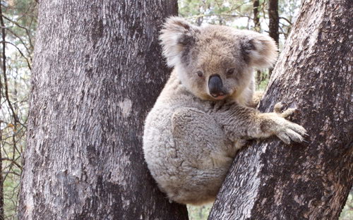
It was a native Blotched Blue Tongue Lizard in this case (scientific species name Tiliqua nigrolutea). It was 10th February 2025 (summer) in the late hot afternoon around 6:30pm AEDT, so the sun was still up in the western sky; this given sunsets in late summer at this time of year are as late as 8 pm, some two hours hence. So, this happenstance timing made sense, but a rare sighting these days.
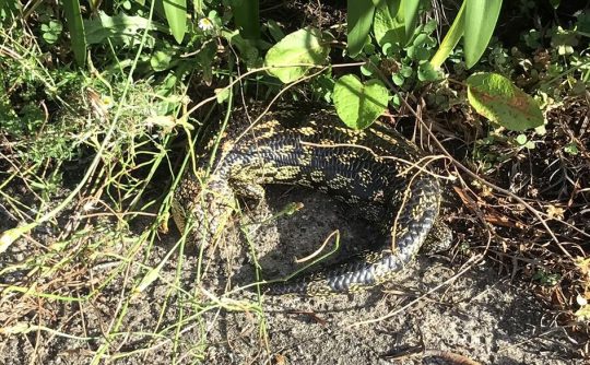 This particular lizard was not easy to then photograph due to it subsequently retreating from the footpath (after we went back for our camera) and retreating into the camouflage cover of the grassy verge behind for safety.
Upon our initial sighting, this lizard had been laying in the middle of the footpath sunning itself – being a cold-blooded lizard (‘ectothermically’ that is; not the human malice variety).
This one we think is female – telling from the comparatively small head size and its thicker tail root. It was not a native Shingleback Lizard (scientific species name Tiliqua rugosa) since such species has a stubbed tail land prefers the habitat plains inland from the Great Dividing Range, and are not found in the Blue Mountains region, whereas Blue Tongues are.
The location was on The Gully’s urban periphery, yet wholly environmentally within the broader Gully Water Subcatchment, where The Habitat Advocate is based. So nice to see wildlife in one’s neighbourhood – we share local wildlife’s neighbourhood.
We provide hyperlinks below to further information and clearer images about this lizard species.
Anyway, it was a pleasurably welcomed and encouraging sighting.
Such sightings however are increasingly rare around these parts these days due to Council’s habitat destruction – pretty much since Council has existed since its origins in Katoomba in 1890, then in 1947 re-branding itself Blue Mountains City Council from being a two adjacent regional municipality/shire councils. Then from November 2000 after the Blue Mountains region was declared an international World Heritage Area, this local Blue Mountains Council has bizarrely extolled its contradictory perceived virtues of being a city within a World Heritage Area – what espousing urban sprawl development and high-rises amongst Eucalyptus habitat?
We bought our house in 2000, which had there since the 1920’s. So, we did not build into bush, but rather it was long existing ‘in-town’, and so technically we just recycled and renovated it. It had had only lawn back and front, but since 2001 we have created an onsite forest and restored much local habitat on site, So, no more grass and we then gave away our lawn mower!
One also recalls that on 13th February back in 2017 around 5:30 pm during a 47o Celsius unseasonal heatwave weather event across New South Wales, observing a large native Eastern Brown Snake (scientific species Pseudonaja textilis) of almost 2 metres in length scurrying across the scorching road surface of our street into the cooler shade of our forested front garden. Well, we chose not to garden or water there for a week afterwards and warned our neighbours. However, we immediately reported this snake sighting to the volunteer-based Wildlife Rescue Service (WIRES) for safety guidance and we spoke to one of their trained snake catchers who gave us helpful and reassuring advice over the phone.
Also, when we first moved in where we are, one had to contend with a native Blue Mountains Funnel Web Spider (scientific name Hadronyche versuta) ground nest in our then unkempt backyard, also unfortunately the native Brown Broadfooted Marsupial Mouse (scientific name is Antechinus stuartii) family over the back fence that we observed, eventually sadly perished.
But it beats living in increasing sprawling concreted, treeless sterile Sydney human megalopolis.
References:
[1] ‘ Blotched Blue-tongue Lizard‘, 2020-11-20, by Australian Museum (Sydney), ^ https://australian.museum/learn/animals/reptiles/blotched-blue-tongue-lizard/
[2] ‘ Shingleback Lizard‘, 2025-04-14, Australian Museum (Sydney), ^ https://australian.museum/learn/animals/reptiles/shingleback-lizard/
[3] ‘ Blue Mountains Reptiles‘, ^ https://www.inaturalist.org/guides/12346
[4] ‘ Blue Mountains City Council‘, by Data.NSW, 2020, NSW Government, ^ https://data.nsw.gov.au/data/organization/about/blue-mountains-city-council#:~:text=In%20May%201946%20Katoomba%20was,the%20Blue%20Mountains%20City%20Council.
[5] ‘ Snake Advice‘, Tuesday, 2017-10-10, WIRES, ^ https://www.wiresmembers.org.au/seasonal-animal-advice/snake-advice
[6] ‘ World Heritage places – Greater Blue Mountains Area‘, Australian Government (its departments change like the wind), ^https://www.dcceew.gov.au/parks-heritage/heritage/places/world/blue-mountains#:~:text=History%20of%20World%20Heritage%20listing,session%20on%2027%20June%202013.
[7] ‘ Fauna Watch – Winter is not the time for hunkering down for Antechinus!, 2019-08-19, by Anne Carey, Bushcare Blue Mountains (Fauna, Natives), ^ https://bushcarebluemountains.org.au/fauna-watch/
Monday, August 19th, 2019
 Giants of the Valley Giants of the Valley
© Acrylic on Canvas by Hannah Lenora Teichert, 2019.
Artist’s Statement:
Although my painting is set in the Styx Valley of the Giants, it transmits childhood memories of ethereal walks amongst the tallest trees found in the Redwood Forests of California. The Mountain Ash trees of Tasmania may arguably have been their contenders, if not for human intervention having commoditised them in their prime. My painting depicts the narrative of these Giants, whose crevassed valleys I have yet to travel.
The relational theme is exemplified through landscapes suspended in space, conveying our universally intricate ties to the natural world; ‘As above so below’. The Giants are fused together by their roots, representing the recently discovered language of trees. Their wiring is juxtaposed with our own ever-escalating dissemination of information.
The native White Bellied Eagle protects his island, which is pockmarked with the scabs of clear felled, old growth forests. The monumental forest transforms from ‘hardy’ to ‘harvested’ and rests amongst machinery within the living limbs of a peace symbol balanced between its adversaries. The aerial perspective above the nest leaves the onus for the forest’s future, inescapably with the viewer.
The ‘Weld Angel’, perched atop a giant tripod, protests peacefully. She embodies repressed respect for mother earth and strives to regain equilibrium with her political nemeses abseiling from what remains of The Valley of the Giants.
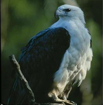 White-Bellied Sea Eagle (Haliaeetus leucogaster) White-Bellied Sea Eagle (Haliaeetus leucogaster)
Source: ^https://www.threatenedspecieslink.tas.gov.au/Pages/White-bellied-Sea-Eagle.aspx
Monday, March 19th, 2018
Bushfire Scenario Was Not Rocket Science
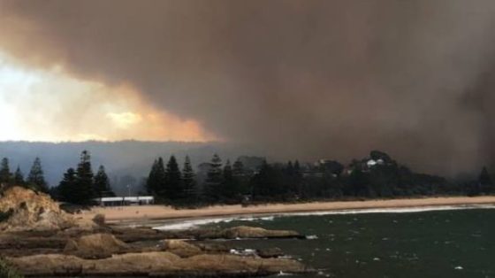
On Sunday 18th March 2018, the weather in Bega and nearby coastal Tathra was forecast to be a very hot 38 degrees Celsius, low humidity and high westerly gusting winds. So a Total Fire Ban was appropriately declared the afternoon prior by New South Wales Rural Fire Service Commissioner Shane Fitzsimmons. The Fire Danger Rating was set locally to just “High”.
Around midday a fire started on or near the rural property at 580 Reedy Swamp Road, situated about 8km SE of Bega on the western edge of the Tanja State Forest, with the outskirts of Tathra situated on the eastern edge just 4km downwind.
When will the ignition source be published so devastated Tathrans learn the truth?
It was a simple fire in bushfire terms. It started adjacent and upwind of state forest bushland in hot windy conditions and kept going in the same direction as the wind blew it until the wind dropped. It was wholly predicable, not rocket science. So the circumstances are indeed suspicious, but we expect a cronyistic cover up.
The nearest bushfire brigade is the Tarraganda Fire Shed on Tarraganda Lane about 6km NW of the ignition site, but government expects local volunteers to respond on standby, under-resourced to defend their community last minute with no financial compensation.
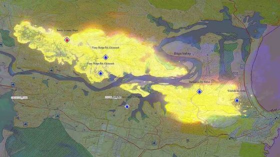
Four kilometres east is the outskirts of Tathra along Thompson Drive across the Bega River. This is locally referred to as the Tathra River Estate – a Bega Council approved satellite suburb invading remnant native habitat.
The Chronically Avoided Questions
- There was no lightning, so what was the ignition source on this day of declared Total Fire Ban?
- How long did it take the RFS to discover the fire after its estimated ignition time?
- How did the RFS learn about the ignition? Proactive real-time geo-stationary low-orbit satellite with infrared camera or just a reactive public call to ‘000’?
- How long did it take the RFS to arrive on site to suppress the fire? We’re talking mum and dad volunteers here, apparently arriving on the fire ground at 12:43pm to do squat.
- What is the point of having fire trails throughout the Tanja State Forest if when there is a bushfire emergency, they are too dangerous to use?
- When did the RFS realise that the gusty winds would spot embers over the Bega River and impact Tathra? When the embers spotted over the river?
- What bushfire preparations and asset protection zones had been in place for Tathra, if any?
- Given that Tathra was obviously bushfire prone, which homes were Bushfire Attack Level assessed and compliant?
- Where was the RFS Erickson S-64 Air-Crane purpose designed helicopter Elvis with its 9,500 litre water dumping capacity?
- Where was the RFS C-130 Thor with its 44,000 litre water dumping capacity? It cruises at 540kph, so from its base at Richmond it could have been deployed and effective over the active fire edge imminently set to impact Tathra within an hour – 360km as the crow flies! – if they were military standard professional.
 The under-resourced pre-1939 volunteer model for the bushfire fighting is a repeated failure The under-resourced pre-1939 volunteer model for the bushfire fighting is a repeated failure
Another Promised Wildlife Sanctuary Goes Up In Smoke
So the fire was left to burn into the Tanja State Forest because, according to the RFS cultural scarce resource mindset, it was not immediately threatening property. She’ll be right. A bit of unauthorised hazard reduction wouldn’t go astray. What habitat?
The fire was only incinerating the flora reserve which provides habitat for one of the last Koalas communities along the Sapphire Coast. The RFS dubbed the fire the Reedy Swamp Fire or the Tarraganda Fire. Residents were only advised to “Watch and Act”, whatever that means.
Then mid-afternoon the wind picked up as per the usual diurnal wind variation profile. So with 38 degrees Celsius and 30 kph plus nor-westerly winds, the fire raced out of control through dense bushland toward the western outskirts of Tathra on the coast. At no time did the fire front change direction. It was heading towards Tathra from the outset.
Incident logs from Sunday show Fire and Rescue NSW, a state government agency, offered additional emergency brigades and assistance at 12:34pm in response to a flood of Triple Zero calls from the area. Those offers were declined before the agency attempted to offer more crews again at 12.58pm – again being rejected.
RFS Deputy Commissioner Rob Rogers said while the fire was burning in remote mountainous terrain, “it would have been dangerous to have [Fire NSW] there”.
The purpose of fire trails? Habitat reduction.
Rural Firefighting Dysfunction
She’ll be right. It was only at 3.40pm that authorities from the Rural Fire Service did request extra help, issuing a priority request for all available assistance, as the fire front rapidly approached Tathra.

Shortly after 2.30pm the bushfire intensified as winds picked up. By 4pm the fire had hit Tathra and NSW Rural Fire Service volunteers warned residents it was too late to leave.
But it wasn’t the 7km bushfire front misreported by the media. The early spread of the bushfire started at around 500m wide and then spread to about a 1500m wide front, spotting ahead as it was fanned by the gusty WNW winds. The bushfire front tracked from the ignition near Reedy Swamp downwind 7 km toward Tathra Head at the coast. The only thing seriously stopping the bushfire was the weather or the sea.
RFS deputy fire commissioner Rob Rogers said the bushfire quickly got out of control after it started yesterday afternoon. “It jumped very quickly to a place called Thompson Drive and that was where the first home was impacted and it just really quickly ran then into the main part of the town,” he said.
By 4:38 pm the RFS was reporting: “EMERGENCY WARNING – Reedy Swamp fire (Bega LGA) – Fire impacting on #Tathra. Seek shelter. It is too late to leave.”
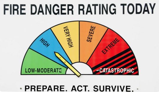 What is the point of having a Catastrophic rating if it isn’t used? What is the point of having a Catastrophic rating if it isn’t used?
Deputy Commissioner Rogers said dealing with nature was not always “an exact science”. “There has been dozens of hazard-reduction activities in that area,” he said. “There was one that was only two or three years’ old and the fire went straight through that burn as well.
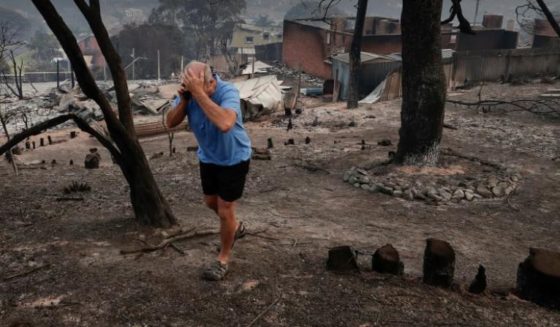
This time 65 homes, 35 cabins and caravans destroyed, and dozens more damaged. Only last January the Tathra Launderette caught fire and destroyed the premises as well as the adjoining Bliss Stylists hairdresser and Little Bottler Tathra Cellars.
But criticism is taboo because the government sends in volunteers, who are automatically beyond reproach. The politicians are very quick to remind us at every bushfire aftermath.
Different Fire, Same Incompetence
The RFS in hindsight are reporting it as “catastrophic” and “a perfect storm”. It’s frankly a bit late Shane Fitzsimmons and are they now furiously shredding their communication records?
“It will never be the same again,” said Renata Boulter, a Tathra resident of 26 years.
 Trust government’s used and abused volunteer force with your livelihood? Trust government’s used and abused volunteer force with your livelihood?
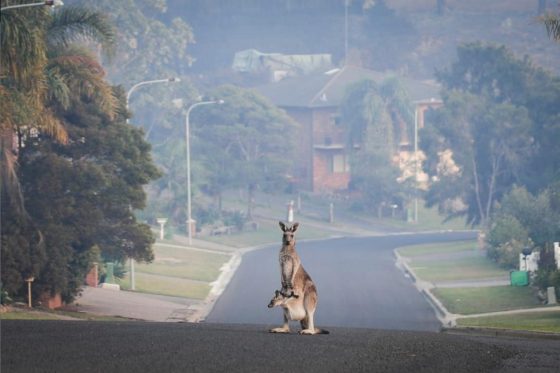
The insurance damage bill will be in the hundreds of millions, again, and that ignores the human, livestock and wildlife cost ignored by a sound bite media. Ina few weeks the ghoulish media filming amongst the ruins in their shiny hi-vis wear will have packed up and moved on.
It’s another Dunalley (Forcett bushfire) (2013), another Yarloop (2016), another Mundaring (2018), another Marysville (2009), Canberra (2003), Cockatoo (1983), Anglesea (1983), Hobart (1967), Leura (1957). On each occasion, the bushfire had been not threatening houses and so wrongly left to burn in some cases for days, then the wind picked up in the afternoon as it usually does and it was all too late.
And the lawyers will no doubt be getting in for their pound of flesh, just like Maurice Blackburn profited $100 million in fees out of the victims of Victoria’s 2009 Black Saturday bushfires. Tathra victims would be well advised to read up on Garry Angus, Kinglake victim, who suffered $4.2 million in economic losses. But after six years trustful waiting, Maurice Blackburn offered him a compensation cheque for $120,000. He sent it back to them in disgust. The lawyers also exposed the victims compensation to a $20 million tax liability – so the government to a cut from the victims compensation as well.
“The whole thing was flawed right from day one. The $494m (for Kilmore East-Kinglake victims) that they settled on was never going to be enough to help people. It needed to be three times that amount.”
(Read Postscript below).
Disaster Waiting to Happen..again
The western outskirts of Tathra, known as Tathra River Estate, bore the brunt of the bushfire. It was subdivided and developed and built out from 2013. The NSW Government Department of Planning and Infrastructure and the Bega Council happily approved the ‘Planning Report: State Environmental Planning Policy No. 71 (Coastal Protection) Master Plan: Tathra River Estate, dated June 2012.
Concerns over the current inadequacies of bushfire access was raised during submissions, as the well as the cumulative impact of additional dwellings and the need for emergency access in the event of a bushfire.
Many of the residential houses decimated by the fire were built between the 1960s and 1980s, in cheap and nasty asbestos. No bushfire tolerance. She’ll be right.
The provision of Asset Protection Zones, connection to the fire trail network and emergency access around the edge of the development apparently addressed many of the concerns. It was then up to Bega Council “to consider other matters in a bushfire emergency strategy.” What did Bega Council do or not do? We suspect cronyistic developer corruption.
The NSW RFS raised no objection to the Master Plan. Yesterday, Tathra River Estate (Thompson’s Drive or Estate) as well as similarly recently approved housing subdivisions extending into the native bushland such as Wildlife Drive and Sanctuary Place, bore the bushfire frontal attack.
 It’s called ‘Wildlife Drive’ for a reason. It’s called ‘Wildlife Drive’ for a reason.
The residential development encroaches upon Tanja State Forest – established in 2017 to protect wildlife
There is shared culpability here, and how did they get home and contents insurance?
 Tathra River Estate/Thompson’s Estate (bottom right of image) – juxtaposed next to Tanja State Forest Tathra River Estate/Thompson’s Estate (bottom right of image) – juxtaposed next to Tanja State Forest
(This is an old image – more development has been allowed since)
It costs $20,000 a day to keep the Elvis air crane on stand-by and an additional $11,000 a day to operate. This extrapolates to $11 million a year to have Elvis ready and able to seriously suppress bushfires. Sounds like a lot of money but the economic loss and emotional cost besetting Tathra residents?
In 2015, the NSW Rural Fire Service unveiled its latest fire fighting weapons, including a monstrous-sized former RAAF C-130 Hercules converhuman ted water-bombing tanker capable of dropping up to 44,000 litres of water on any bushfire any time. It costs a bomb, but what cost Australian livelihoods?
The official economic cost of the Dunalley (Forcett) bushfire was $100 million, the Yarloop bushfire $45 million, Marysville $300 million and Canberra $300 million.
Melbourne University’s follow up study into the human aftermath of Victoria’s 2009 Black Saturday bushfires reported a quarter of survivors still experiencing serious mental health problems six years later, including affected children. (Read report below under Further Reading’)
“The reality of the disaster and its aftermath formed the ongoing backdrop of children’s daily lives. Children from a very young age through to older youth experienced anxieties and upheavals at home, in school, in sport, in friendship groups and in the community.
“She had so much trouble going back to school. She couldn’t think, concentrate at all. Everything seemed irrelevant that she was doing and they tried so hard. They were very helpful but she had a lot of trouble with just fitting in with the kids that she knew before there. They weren’t understanding her and she just felt that all their problems were very trivial.”
(Parent)
 Photo by Ngaire Walhout Photo by Ngaire Walhout
Lessons To Be Blocked by Cronyism..again
Of course there will be another government enquiry, so the government is seen to given a damn. There are the same number of government enquiries as there have been bushfire tragedies since the Black Friday back in 1939. It concluded – “Mistakes We’re Made”, and then the report gets filed and bushfire fighting returns to business as usual and set to repeat history.
The 1939 Black Friday fires in Victoria burned almost two million hectares, claimed 71 lives and destroyed more than 1,000 homes, including entire townships. In adjusted terms, these fires cost some $750 million.
On 1983 Ash Wednesday fires in Victoria and South Australia claimed 75 lives, more than 2,000 homes and over 400,000 hectares of country. Total property losses were estimated to be over $400 million. Between 1967 and 1999, bushfires in Australia resulted in 223 deaths and 4,185 injuries, and a total economic cost of more than $2.5 billion. Victoria’s Black Saturday in 2009 cost $4.4 billion and 173 lives.
For Tathra yesterday, it could and should have been responsible, militarily heroic, and quite beautiful – professional fire suppression like Sydney gets, where emergency professionals have proper resources at their disposal, are properly remunerated, and so residents entrust the firies to save their homes and family.
 Where was it parked this time? Where was it parked this time?
In 2017 the NSW Government delivered a $4.5 BILLION surplus, so they are not exactly struggling.
Tathra is a microcosm of Victoria’s bush-enclosed Mornington Peninsula coastal residence west of Rosebud; timber and fibro shacks enveloped in a tinder dry tea-tree forest – in a bushfire Forest Fire Danger Index scary scenario – another catastrophic crematorium waiting to happen.
What does the land manager National Parks Service say about Tanja State Forest? It is part of the Murrah Flora Reserves which encompasses 4 areas covering nearly 12,000 hectares and include Murrah, Mumbulla, Bermagui and Tanja flora reserves along the New South Wales Sapphire Coast. The Murrah Flora Reserves were created in March 2016 and are significant to the local Aboriginal Yuin People who own neighbouring Biamanga National Park. They also provide an important conservation role, as habitat for the last significant koala population on the NSW South Coast and other threatened species, such as the long-nosed potoroo, yellow-bellied glider and the powerful owl.
Of course it was “overgrown”. It’s called wildlife habitat. And firies, it’s scarce and valuable and worth defending. It is not expendable. yet another 1200 hectares of native habitat set aside for supposed sanctuary has been incinerated. It was a defacto RFS hazard reduction again gone wrong.
NSW National Parks and Wildlife Service:
“The national and state forests within the Sapphire Coast are home to some of the most iconic views and breathtaking landscapes in Australia. The South Coast’s outstanding national park system offers visitors a wide choice of opportunities to discover spectacular landscapes, from dense forests to quiet, solitary beaches; from cool, silent rainforests to colourful, alpine wilderness wildflowers. The national parks a diversity of unspoiled habitats and ecosystems which offer refuge to unique, and often ancient, plants and animals found nowhere else on Earth.”
Hypocrites!
 Koala in the Murrah Flora Reserve, probably incinerated. Photo by David Gallan. Koala in the Murrah Flora Reserve, probably incinerated. Photo by David Gallan.
Source: Far South Coast Conservation Management Network
^http://www.fsccmn.com/?p=2151
Footnotes
‘Angry survivor returns Black Saturday payout to ‘only winner’, Maurice Blackburn‘, 20170501, by Reporter Pia Akerman published in The Australian Newspaper, ^https://www.theaustralian.com.au/in-depth/bushfires/angry-survivor-returns-black-saturday-payout-to-only-winner-maurice-blackburn/news-story/ea9fe705b2616852235851e62424adea.
“I’ve lost the value of my business, I’ve lost everything.”
Garry Angus and Anne Salmon on a block they own outside Kinglake. Photo by Stuart McEvoy
‘As cheques from the record-breaking Black Saturday class actions finally began flowing to bushfire survivors in December, many of the victims welcomed the payments as the end of another chapter in their emotional and financial recovery.
Not Garry Angus. He, with an unquantified number of the thousands of claimants who joined the lawsuits, remained angry about Maurice Blackburn’s handling of the cases. The accountant from Pheasant Creek, just outside Kinglake, decided to put his money where his mouth is and sent back his cheque for $120,000.
Now he is launching a website for fellow survivors to register their complaints about Maurice Blackburn’s administration of the settlement scheme. He hopes support from other aggrieved claimants will bolster his bid for a judicial review of the $494 million Kilmore East-Kinglake settlement and the $300m settlement for the Murrindindi-Marysville fire, announced in 2014 and 2015 respectively.
“The only winners out of this have been Maurice Blackburn,” Mr Angus said. “The whole thing was flawed right from day one. The $494m (for Kilmore East-Kinglake victims) that they settled on was never going to be enough to help people. It needed to be three times that amount.”
Like a number of other bushfire survivors who have spoken publicly, Mr Angus is angry at the fees Maurice Blackburn has stripped from the settlements — more than $100m — and the Australian Taxation Office’s claim that the firm has acted unusually to expose the funds to a tax liability of about $20m. He is also furious at how his case was personally handled, claiming that the firm was lax in communicating with him, and only junior staff dealt with him (even misspelling his name on his formal assessment notice).
Before the February 2009 bushfires, Mr Angus owned and managed an accounting firm that employed eight people. He owned four investment properties around the Kinglake area, losing two completely to the blaze.
He brought a 2000-page tome of his financial records with him to his meeting with assessor Neil Rattray, and says the barrister was clearly overwhelmed and admitted he might not be the best person to handle this complex case.
Mr Angus’s claim for $4.2m in losses — largely based on future earnings from his firm, which he closed while struggling with post-traumatic stress disorder in the fires’ aftermath — was dismissed by Mr Rattray. The barrister did not accept he would suffer from any future loss of earnings or earning capacity, arguing that his business had been struggling and there was “no real suggestion” the company would be successful in the future.
In a submission to Supreme Court judge Jack Forrest, who oversees the Kilmore East settlement scheme’s administration, Mr Angus has accused Maurice Blackburn of failing in its duty of care, and asked for an independent review.
Maurice Blackburn has stood by the assessment, saying Mr Angus missed his chance to formally request a review (for which the firm charges $3800 if the finding is against the claimant).
“Given Mr Angus never objected or asked for a review during the assessment process, it’s an odd protest to now hand back a substantial cheque because of a desire to obtain more money,” a spokesman said.
Mr Rattray told The Australian he could not comment on Mr Angus’s claims, but in the reasons for his assessment, he noted that Mr Angus had treatment for depression and panic attacks before the bushfires. Since the fires, he has been suicidal at times, needing extensive medical treatment and occasional hospitalisation.
“It has psychologically scarred me for the rest of my life,” Mr Angus said. “I’ve lost the value of my business, I’ve lost everything.’’
Further Reading:
.
[1] ‘Bushfire emergency, houses destroyed in Bega, Tathra area‘ 20180319, by Ben Smyth, in The Land, ^http://www.theland.com.au/story/5290860/bushfire-emergency-houses-destroyed-in-bega-tathra-area/
.
[2] Murrah Flora Reserves Draft Working Plan 2017, by NSW National Parks and Wildlife Service, and Forestry Corporation (NSW Government), ^http://www.environment.nsw.gov.au/research-and-publications/publications-search/murrah-flora-reserves-draft-working-plan
.
[3] Submission on Murrah Flora Reserves Draft Working Plan, 20180131, by South East Conservation Alliance Inc. ^www.serca.org.au/submissions/2018/thompson1.pdf
[4] Tathra River Estate DOP Assessment Report 2012 >https://www.habitatadvocate.com.au/wp-content/uploads/2018/03/Tathra-River-Estate-DOP-Assessment-Report-2012.pdf
.
[5] ‘Tasmania’s Forcett Fire 2013 – 16 questions‘, 20130203, by The Habitat Advocate, >https://www.habitatadvocate.com.au/?p=21167
.
[6] ‘Culpable Negligence of Tasmanian Burn Offs‘, 20130105, by The Habitat Advocate, >https://www.habitatadvocate.com.au/?p=20848
.
[7] 2013 Tasmanian Bushfires Inquiry Full Report, Vol. 1, >www.dpac.tas.gov.au/__data/assets/pdf…/1.Tasmanian_Bushfires_Inquiry_Report.pdf
.
[8] Beyond Bushfires: Community Resilience and Recovery, Final Report 2016, by the University of Melbourne, ^http://beyondbushfires.org.au, >https://www.habitatadvocate.com.au/wp-content/uploads/2018/04/Beyond-Bushfires-Final-Report-2016.pdf
.
[9] Threats from Bushfire, article series by The Habitat Advocate, >https://www.habitatadvocate.com.au/?page_id=6954
.
Tags: fire volunteers, Reedy Swamp Fire, RFS, Rural Fire Service, Tanja State Forest, Tarraganda Fire, Tathra, Total Fire Ban
Posted in Endangered Wildlife (EN), Koalas, Owls, South East Corner (AU), Threats from Bushfire | No Comments »
Add this post to Del.icio.us - Digg
Wednesday, July 26th, 2017
 Elphinstone Plateau from the north Elphinstone Plateau from the north
© c.1991 Wyn Jones (biologist, NPWS)
Elphinstone Plateau is magnificently wild, forming an outstanding undeveloped peninsula-plateau jutting out into the Megalong. It has long been a favourite wilderness destination for bushwalkers and rock climbers alike.
This predominantly natural and undisturbed plateau is mistakenly also referred to as ‘radiata plateau‘ due to a small invasive private pine plantation from the 1970s covering less that 5% of the plateau along an access track . The plantation failed and the owner went broke.
Yet little known Elphinstone Plateau remains special home to rare and threatened regionally native species, culturally significant to local Aboriginal peoples and a magnet for the local outdoor community.
Sitting on the southern escarpment, Elphinstone Plateau, just west of Katoomba, towers high above rolling valleys has outstanding topography. It remains the last remaining undeveloped peninsula-plateau in the upper Blue Mountains. The Plateau has significant biodiversity, including vegetation communities such Blue Mountain Swamps, Eucalyptus Oreades Open Forest and Blue Mountains Heath. It is also home to many endangered species including the Flame Robin, Glossy Black Cockatoo, Gang-Gang Cockatoo and the Varied Sittella as well as the Tiger Quoll, frequently sighted by locals. Threatened plants include one of only ten places on the planet where the Dwarf (Blue) Mountain Pine (Pherosphaera fitzgeraldii) is endemic on the planet to the immediate upper Central Blue Mountains with its distribution fragmented to a few south-facing hanging swamp cliff faces on the Blue Mountains western escarpment at Elphinstone above Nellies Glen and nearby around Wentworth Falls above the Jamison Valley.
The IUCN reports that this taxon is endangered. It faces a very high risk of extinction in the wild in the near future due to a small population size and severe population fragmentation, with no sub-population estimated to contain more than 250 mature individuals.
 The Dwarf Mountain Pine endemic on the planet to wet rocks within the spray of waterfalls of Elphinstone and Wentworth Falls The Dwarf Mountain Pine endemic on the planet to wet rocks within the spray of waterfalls of Elphinstone and Wentworth Falls
(Harden 1990, Hill 1998)
Steven, one of our local conservationists says that this wild plateau has significant biodiversity – Blue Mountain Swamps, rare Eucalyptus oreades Open Forest and many endangered species including the Flame Robin, Glossy Black Cockatoo, Gang-Gang Cockatoo, and the almost unknown Tiger Quoll.
 One of our local conservationists at Megalong Head on Elphinstone Plateau One of our local conservationists at Megalong Head on Elphinstone Plateau
Steven says that the plateau and its immediate surrounds provide are the only locality on the planet to naturally support the critically endangered Dwarf Mountain Pine and the little-known yellow flowering shrub Elphinstone Boronia (Leionema lachnaeoides). Both are threatened with extinction and their survival depends on the area remaining undisturbed.
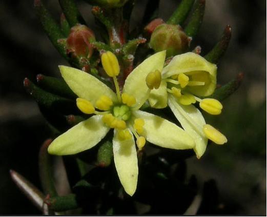 Threatened species Elphinstone Boronia (Leionema lachnaeoides) Threatened species Elphinstone Boronia (Leionema lachnaeoides)
Endemic to Elphinstone Plateau (that means it grows natively nowhere else on the planet)
© Waratah Software
Survival depends on the area remaining undisturbed.
Steven says local resident Glenn Humphreys has been involved with trying to protect and save Mount Elphinstone from housing development on and off for more than 25 years, successfully halting all sorts of elaborate development proposals.
But now this wild and unique haven is at risk. An integrated part of the Blue Mountains western escarpment has come under threat of land use development again – Mount Elphinstone (also mistakenly called Radiata Plateau) situated a few kilometres west of Katoomba. Apart from a small area of Crown Land the majority of the Plateau is privately owned by a group that have repeatedly lodged development applications since the 1990s.
Elphinstone Namesake
Mount Elphinstone, being the highest rise on the plateau is believed named after Major General Sir Howard Craufurd Elphinstone, VC, KCB, CMG (1829 – 1890) who was a British Army officer and a recipient of the Victoria Cross.
Born in Livonia (now Estonia), Elphinstone joined the British Corps of Royal Engineers as a gentleman cadet at the Royal Military Academy, Woolwich and was commissioned as a second lieutenant in December 1847. With the outbreak of the Crimean War, Elphinstone was posted to the Crimea.
On 18 June 1855, he was 25 years old, and a lieutenant in the Royal Engineers, during the Siege of Sebastopol when the following deed took place for which he was awarded the Victoria Cross.VC.
His citation read:
“For fearless conduct, in having, on the night after the unsuccessful attack on the Redan, volunteered to command a party of volunteers, who proceeded to search for and bring back the scaling ladders left behind after the repulse; and while successfully performing this task, of rescuing trophies from the Russians, Captain Elphinstone conducted a persevering search, close to the enemy, for wounded men, twenty of whom he rescued and brought back to the Trenches.”
With the end of the war he was decorated by both Napoleon III, Emperor of France being appointed as a Knight of the Legion of Honour.
Private Development Threats to the Plateau
A proposed private development threatens its future. Currently, two of three development applications recently lodged have been refused, leaving one approved for two dwellings. They pose an inappropriate development wedge to future residential exploitation of this still wild plateau.
Now is the time to prevent any building and move the Plateau in public ownership for protection. This could be the public’s last chance to secure the future of this stunning area and have Elphinstone Plateau become part of the National Park estate.
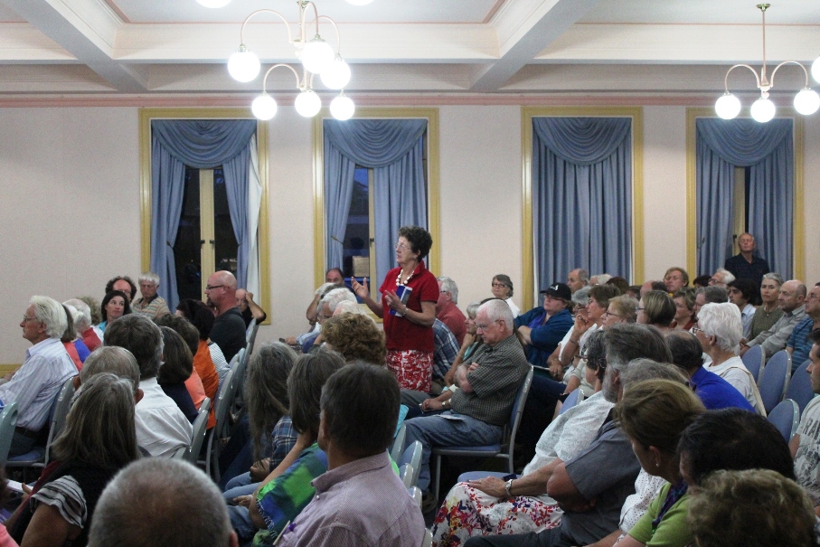
Blue Mountains residents, the local outdoor community, and the Blue Mountains Conservation Society are all firmly committed to seeking protection for the Plateau. We were delighted with all the community support our campaign received at Winter Magic – with lots of cheers from the crowd during the parade and most importantly all the letters sent off to the Minister for the Environment.
We are seeking to have Elphinstone Plateau purchased by the New South Wales or Australian Commonwealth governments and be incorporated into the Blue Mountains World Heritage Area.
But the battle is not yet won. The local Blue Mountains Conservation Society is championing an environmental campaign to oppose the land use development and to have the plateau incorporated into the adjacent Blue Mountains World Heritage Area.
The Society is inviting locals and those passionate about protecting this special place, to join in a rally on Sunday 30th July at 1.30pm at Cahill’s Lookout, Cliff Drive, Katoomba.
Further Reading:
.
[1] Leave Radiata Plateau Wild Campaign, ^ http://www.bluemountains.org.au/leaveradiataplateauwild/
.
[2] Elphinstone (Radiata) Plateau – Bushwalk: Bottleneck Pass and The Devils Hole (29 June 2016) by Dave Noble (NPWS), ^ http://www.david-noble.net/blog/?p=11300
.
[3] Dwarf Mountain Pine (Pherosphaera fitzgeraldi), The Gymnosperm Database, ^ http://www.conifers.org/po/Pherosphaera_fitzgeraldi.php
.
[4] Major General Sir Howard Craufurd Elphinstone, ^ https://en.wikipedia.org/wiki/Howard_Craufurd_Elphinstone
.
Friday, October 10th, 2014
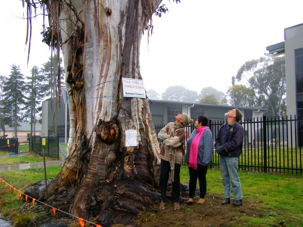 Katoomba residents Maureen and Peter Toy with Glenn Humphreys (right) marvel at Katoomba’s largest native tree
[Photo © Friends of Atlas, 20140907, click image to enlarge] Katoomba residents Maureen and Peter Toy with Glenn Humphreys (right) marvel at Katoomba’s largest native tree
[Photo © Friends of Atlas, 20140907, click image to enlarge]
.
Residents of the Blue Mountains, Maureen and Peter Toy, were shocked to learn last month about an arbitrary claim for this magnificent tree (pictured) to be killed for what they consider can be no rational reason.
According to advice that the Toys received from local conservation consultancy The Habitat Advocate, this large Blue Mountains Ash (Eucalyptus oreades) is a native tree only found in the Upper Blue Mountains. This particular specimen probably dates to 19th Century colonial settlement in Australia.
Maureen says “It is a beautiful and rare specimen and Blue Mountains folk are fortunate that we have such a significant tree still growing right by Megalong Street in now an increasingly industrialised part of Katoomba.”
Over the many decades, this great tree has withstood fierce windstorms, bushfires, road-widening right up to its trunk and industrial development all around it. With a canopy about 40 metres high and a trunk girth of over 5 metres, the tree has become a recognised icon and reference point in the area. It is home to a flock of sulphur-crested cockatoos.
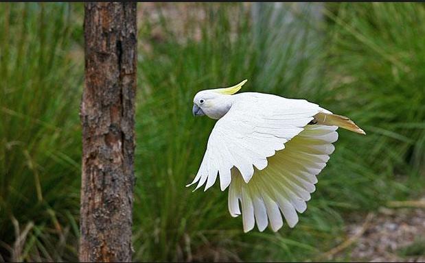 Sulphur-crested Cockatoo (Cacatua galerita)
These character parrots may be of ‘Least Concern’ to IUCN, but to the clan of cockies habitating Atlas, this is their home.
[Source: Zoos Victoria, ^http://www.zoo.org.au/healesville/animals/sulphur-crested-cockatoo] Sulphur-crested Cockatoo (Cacatua galerita)
These character parrots may be of ‘Least Concern’ to IUCN, but to the clan of cockies habitating Atlas, this is their home.
[Source: Zoos Victoria, ^http://www.zoo.org.au/healesville/animals/sulphur-crested-cockatoo]
.
Maureen affectionately calls the tree, ‘Atlas’, after the Greek God, for its towering size and for being so enduring. There is no other quite like it perhaps throughout the world renown Blue Mountains World Heritage Area.
Peter can’t understand why the tree is not on Council’s Significant Tree Register or why anyone would want to harm it. The tree is on community verge land and for the past few years there has been an industrial development constructed behind it. Peter and Maureen are vehemently opposed to any further harm being inflicted upon the tree and they have lodged a protest with council.
Several others in the local community have sided with the Toys and together have formed a local group ‘Friends of Atlas’ determined to protect the tree. Peter is looking to start a petition to garner local community recognition and support to protect the tree. He says “it is early days but he is ready for a sustained fight.”
A spokesperson from Blue Mountains (city?) Council has confirmed that the tree is situated on ‘Community Land‘ on the verdant verge strip between the street and the new industrial development at number 59 Megalong Street. The tree and its canopy and root system is not on private land, but on Community Land. Council has a duty as the community-delegated custodian of all community lands throughout the Blue Mountains Local Government Area. Council does not ‘own’ the tree per se, rather Council acts as the responsible custodian of this significant tree.
Council has stipulated in its development consent conditions for the adjoining industrial development application since 2010 that the tree must not be harmed by the current development activity.
But Peter disagrees. He says “guttering has been dug right into the tree roots system and just a month ago the developer had a bobcat grade the topsoil and roots around the tree for an entire day!.”
Council’s spokesperson says that council has not received any request for the tree to be destroyed.
A battle to save the tree is set to ensue.
.
Further Reading:
.
[1] Campaign Facebook Page: ^https://www.facebook.com/friendsofatlas
.
[2] Greater Blue Mountains World Heritage Area, ^http://whc.unesco.org/en/list/917
.
[3] Blue Mountains (city?) Council’s promotional tourism hypocrisy (or ‘greenwashing‘): ”
<<The Greater Blue Mountains World Heritage Area only exists today because of a 70-year campaign by conservationists to achieve a chain of reserves across the region. This culminated in the year 2000 with the acceptance of 10,000 square kilometres of wild bushland onto the World Heritage list – the ‘best of the best’.>>
Source: Blue Mountains (city?) Council, ^http://www.greaterbluemountainsdrive.com.au/
.
…70 years hence, this is the same reason why conservationists ‘Friends of Atlas’ have started a campaign. Atlas is the “best of the best”.
.
Saturday, October 12th, 2013
 Ecological consultant David Paul with a koala found in the Leard State Forest
[Source: Photo by Tania Marshall, Front Line Action on Coal,
^http://frontlineaction.wordpress.com/] Ecological consultant David Paul with a koala found in the Leard State Forest
[Source: Photo by Tania Marshall, Front Line Action on Coal,
^http://frontlineaction.wordpress.com/]
.
Environmentalists are urging the New South Wales and Australian governments to save the Leard State Forest. They are concerned about the catastrophic impact of major mining expansion on an isolated and vulnerable koala colony in its natural habitat within the Leard State Forest.
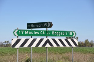
The Leard State Forest is situated near Maules Creek within the Namoi River catchment about 10km north-east of the township of Boggabri on the North West Slopes of New South Wales, about 500km nor’-nor’-west of Sydney.
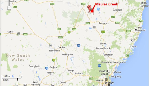 Maules Creek Mine location map
[Source: Google Maps] Maules Creek Mine location map
[Source: Google Maps]
.
The nearby town of Boggabri lies on the Namoi River, a major perennial river and floodplain within the Murray-Darling Basin. The landscape is naturally subjected to infrequent seasonal rains and widespread flooding.
.
 . .
The native vegetation has been naturally dominated by Box-Gum Woodland ecological communities featuring the endemic species of White Box, Pilliga Box and Bimble Box. These provide vital habitat for numerous woodland bird and microbat species and a small community of Koalas.
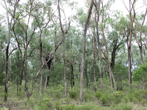 The Leard State Forest
An isolated remnant box woodland The Leard State Forest
An isolated remnant box woodland
.
The region was originally the Aboriginal land of the Kamilaroi people and their ‘place of many creeks‘. However, two hundred and twenty five years of colonial pastoral settlement and associated widespread deforestation has seen the region denuded of most native vegetation historically for sheep and wheat; and more recently for irrigated cropping, particularly water thirsty cotton.
.
 Box Woodland decimated for industrial scale cotton
The farming model is entirely artificially dependent river-diverted irrigation for export produce.
[Source: Promotional tourism advertisement by the NSW Government,
^http://www.visitnsw.com/destinations/country-nsw/moree-and-narrabri-area/gallery] Box Woodland decimated for industrial scale cotton
The farming model is entirely artificially dependent river-diverted irrigation for export produce.
[Source: Promotional tourism advertisement by the NSW Government,
^http://www.visitnsw.com/destinations/country-nsw/moree-and-narrabri-area/gallery]
.
Native habitat has been sadly reduced to a few isolated islands of land set aside as ‘State Forests’. These include the Pilliga Forest, the largest remnant temperate forest in Eastern Australia, as well as Jacks Creek, Plagyan, Rusden and Leard State Forests, as well as the rugged Mount Kaputar National Park.
Leard State Forest includes the most extensive and intact stands of the nationally listed and critically endangered Box-Gum Woodland remaining on the Australian continent and is home to nearly 400 native species of plants and animals, and includes habitat for 34 threatened species and several endangered ecological communities.
.
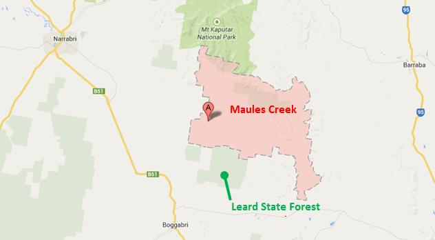 Leard State Forest location map
[Source: Google Maps] Leard State Forest location map
[Source: Google Maps]
.
It’s believed as few as 20 koalas are left in the Leard State Forest, which is considered its primary habitat. The primary food source for the koalas is thought to be the Pilliga Box, Red Gums and Yellow Boxes. This Koala population is very fragile and could be significantly impacted on by the future mining plans.
Ecological consultant David Paul:
“If they are part of the same population as the Pilliga koala, then Leard is a very important area for allowing the dispersal of these animals in an east west direction. Leard Forest is a stepping stone between habitat in the Pilliga and to the east and south. While there are not many koalas there it’s a very important area to allow the dispersal of koalas in the region.”
 Koala in Leard State Forest
[Source: Photo by Tania Marshall, Front Line Action on Coal,
^http://frontlineaction.wordpress.com/] Koala in Leard State Forest
[Source: Photo by Tania Marshall, Front Line Action on Coal,
^http://frontlineaction.wordpress.com/]
.
.
Whitehaven Coal mining expansion into the Leard State Forest
.
<< Approval has been given for one of the biggest open-cut coal mines in the world in the state’s north-east. Whitehaven’s Maules Creek Project, near the Leard State Forest, will extract 12 million tonnes of raw coal a year.
If given the final go ahead from the Federal Government, Whitehaven expects production to start mid-2013, with operations predicted to last around 30 years.
Managing director Tony Haggarty:
“The mine will be good for the region economically and good for the state. It’s one of the best coal developments in the world. It’s a large reserve, it’s very good quality. It’s the sort of coal that is in demand in the market place, and because the reserve is large and because it has a long life, there will be a significant area of land involved.”
.
But Federal Environment Minister Tony Burke says the project will now face Commonwealth scrutiny. It will examine the mine’s potential impacts on the nearby critically endangered white box woodland.
An Environment Department spokeswoman says once the assessment is complete, it will go before Mr Burke who will consider the advice of the department, the Independent Expert Scientific Committee on possible water impacts, and any public comments.
Environmentalist Phil Spark:
“The planning commission’s approval is a blow to the endangered trees and animals that live in the forest. My biggest concern is that the environment has been totally undervalued. You just can’t destroy a forest and think it’s going to be compensated. It’s an endangered ecological community and it just can’t be replaced.”
The Maules Creek Project is about 18 kilometres north of Boggabri in the Gunnedah Basin. >>
.
[Source: ‘Go ahead for one of world’s largest coal mines’, 20121025, ^http://www.radioaustralia.net.au/international/2012-10-25/go-ahead-for-one-of-worlds-largest-coal-mines/1035960]
.
 Nearby Boggabri Open Cut Coal Mine, owned by Whitehaven Coal
Saw thousands of hectares of native Box Woodland bulldozed in 2006. Nearby Boggabri Open Cut Coal Mine, owned by Whitehaven Coal
Saw thousands of hectares of native Box Woodland bulldozed in 2006.
.
Environmentalists are up in arms over a proposal to mine two thousand hectares of state forest, among it, this remnant koala habitat.
The Maules Creek Mine adjoining the Leard State Forest has received NSW government approval to expand into the forest, which will see most of the forest and its flora and fauna all but completed bulldozed into history.
Whitehaven Coal wants a new open-cut coalmine that will extract up to 13 million tonnes of coal a year to earn it $767 million. It also wants a second nearby Idemitsu Boggabri open cut mine to extract 7 million tonnes a year.
Greens Senate Candidate Cate Faehrmann:
“These approvals will literally change the face of the township of Gloucester as well as the small community of Maules Creek near Narrabri in the state’s north-west. The Maules Creek and Boggabri proposals were referred to the Federal environment minister Tony Burke because they are going to wipe out critically endangered forest which is home to many threatened species. How can any Environment Minister in their right mind approve this?
The Maules Creek coal mine alone will emit the same amount of carbon emissions each year as New Zealand during its proposed 30 year life span. This is disgraceful and it’s why communities everywhere are starting to call on the government to transition away from coal and towards a secure renewable energy future.
I have visited the site of the proposed Maules Creek coal mine recently to see the forest firsthand and saw a koala up close in the forest. Tony Burke has just approved a coal mine which will wipe out a small and vulnerable koala population
“The farmers who have been fighting coal mine proposals in Leard State Forest for years will continue to fight for the protection of their forest.”
.
Up until recently, Whitehaven Coal has been owned by multimillionnaire Nathan Tinkler. Its chief executive is Paul Flynn and one of its directors is former National Party leader Mark Vaile. In June 2013, after securing his Maule’s Creek Mine expansion approval, Tinkler sold off most of his shareholdings in Whitehaven Coal to an American profiteering investment capital firm, Farallon Funds.
Whitehaven Coal has been challenged in the courts against its proposal to mine the Leard State Forest by the Northern Inland Council for the Environment. This community based not-for-profit group has said the Federal government was wrong to approve the project. They are challenging the approval process of both the Maules Creek and nearby Idemitsu Boggabri coalmines “because of the dodgy process by which they were approved and the devastating impacts they will have”.
Whitehaven Coal chief executive Paul Flynn has insisted the court challenge to the approval of the Maules Creek mine in NSW will not stop the project and is merely a “frustrating niggle“.
Last financial year Whitehaven made a loss of $82 million.
.
[Sources: ‘Whitehaven carries on with project despite legal challenge’, 20130720, by Michael Hobbs and AAP, ^http://www.afr.com/p/national/whitehaven_carries_on_with_project_z0EwnCKbgJE1Xnrp3wJVoO; ‘Whitehaven Coal falls to $82m loss’, 20130827, by Greg Roberts, Sydney Morning Herald, ^http://news.smh.com.au/breaking-news-business/whitehaven-coal-falls-to-82m-loss-20130827-2sndo.html; ‘Tinkler sells out of Whitehaven’, 20130619, by Glenda Kwek, Sydney Morning Herald, ^http://www.smh.com.au/business/mining-and-resources/tinkler-sells-out-of-whitehaven-20130619-2ohnj.html; ‘Mining proposal puts koala habitat under threat’, 20121109, by Liv Casben, ABC media, ^http://www.abc.net.au/news/2012-11-09/mining-proposal-puts-koala-habitat-under-threat/4363234; ‘Concern for Koala’s in the Leard State Forest’, 20121112, by Kelly Fuller, ABC media, ^http://www.abc.net.au/local/audio/2012/11/12/3630754.htm; ‘Labor turns back on NSW environment’, 20130211, by Cate Faerhmann, ^http://catefaehrmann.org/tag/mining/]
.
Listen to ABC Radio interview with Ecologist David Paul in 2012:
 (Click icon and play audio on the ABC Radio website, turn up volume to listen)
[Source: ‘Concern for Koala’s in the Leard State Forest’, 20121112, radio interview by Kelly Fuller, Morning Show, ABC Radio New England NSW,
^http://www.abc.net.au/local/audio/2012/11/12/3630754.htm] (Click icon and play audio on the ABC Radio website, turn up volume to listen)
[Source: ‘Concern for Koala’s in the Leard State Forest’, 20121112, radio interview by Kelly Fuller, Morning Show, ABC Radio New England NSW,
^http://www.abc.net.au/local/audio/2012/11/12/3630754.htm]
.
.
.
Further Reading:
.
[1] Front Line Action on Coal, (a community-based environmental activist group), ^http://frontlineaction.wordpress.com/
.
[2] ‘Koala habitats in danger as bushland areas are bulldozed‘, 20121011, Sydney Morning Herald, ^http://www.smh.com.au/environment/animals/koala-habitats-in-danger-as-bushland-areas-are-bulldozed-20121011-27fjw.html
.
[3] ‘Mining proposal puts koala habitat under threat‘, 20121109, ABC News, ^http://www.abc.net.au/news/2012-11-09/mining-proposal-puts-koala-habitat-under-threat/4363234
.
[4] ‘Burke approves huge gas and coal plans‘, 20130212, by Ben Cubby, Paddy Manning, Sydney Morning Herald, ^http://www.smh.com.au/federal-politics/political-news/burke-approves-huge-gas-and-coal-plans-20130211-2e8vh.html
.
<< A clutch of big coal and coal seam gas projects, including the controversial Whitehaven mine near Narrabri in NSW, have been approved by the federal Environment Minister, Tony Burke. He signed conditional approvals for Whitehaven’s Maules Creek mine, planned for the Leard State Forest, Idemitsu’s neighbouring Boggabri coalmine expansion, and a coal seam gas development planned by AGL for Gloucester in NSW.
Together, the three resources projects would have a huge carbon footprint of 47 million tonnes of greenhouse gases a year – about 8 per cent of Australia’s total emissions – according to environmental impact assessments. Whitehaven, part-owned by embattled coal baron Nathan Tinkler, was subject to a damaging hoax when anti-coal campaigner Jonathan Moylan issued a fake press release claiming ANZ had stopped funding the project, causing a temporary drop in the miner’s share price. His protest is being investigated by the Australian Securities and Investments Commission.
The mining projects had all been approved at state level. Mr Burke’s signature was seen as the final obstacle to development.
”Of all the decisions I have ever made, this is the one where I have the least idea of whether the projects are going to go ahead,” he said. ”For all three projects there are substantial issues.”
Some of the hurdles yet to be overcome are the preservation of a ”biodiversity corridor” in the Leard Forest to allow koalas and other vulnerable animals to survive, high quality offsets to partially compensate for sections of the forest which would be cut down, and a hydrogeological survey around Gloucester.
Mr Burke compared Monday’s decision to the approval granted by former environment minister Malcolm Turnbull to the proposed Gunns pulp mill in Tasmania. That process involved a series of separate ”modules” that stretched the approvals process out for years, before the project was finally canned.
Asked if his coal and coal seam gas decisions then amounted to ”Clayton’s approvals”, Mr Burke said: ”It’s a completely fair criticism. I would have much preferred to do things in the usual way, and give clear approvals or rejections. Unfortunately the NSW government chose to leak commercial information, and caused this process.”
Mr Burke was referring to a confidential letter from him to the NSW government, obtained by Fairfax Media, flagging his intention to approve the Whitehaven mine late last year. He said NSW would be excluded from the further approvals process because the letter was leaked.
Also on Monday, the NSW government granted conditional approval for an expansion of BHP Billiton’s Dendrobium coalmine south-west of Sydney. Five longwall coal panels will be dug beneath Sydney’s drinking water catchment, with some surface damage expected to eight ”upland swamps” – rare ecosystems that support a variety of plants, birds and amphibians.
The managing director of Whitehaven, Tony Haggarty, welcomed the approval and said: ”Notwithstanding the stringent environmental conditions which have been placed on the project and the difficult coal market at present, this is an excellent project and Whitehaven will be seeking to bring it into production as soon as possible.”
An AGL spokeswoman also welcomed the approval and said it would work on satisfying the 36 conditions on matters of national environmental significance and protection of groundwater.
”Conservationists are furious about Minister Burke’s decision,” said the chief executive of the Nature Conservation Council of NSW, Pepe Clarke. ”Leard Forest is a rich natural habitat, teeming with life, and this decision marks the death knell of this extraordinary area.” The NSW Greens said the series of approvals made for ”a very black day for the environment in NSW”. >>
.
[5] ‘Whitehaven Coal gets Maules Creek green light‘, 20130926, The Australian Newspaper, ^http://www.theaustralian.com.au/business/mining-energy/whitehaven-coal-gets-maules-creek-green-light/story-e6frg9df-1226727476581]
.
[6] ‘Leighton to build Maules Creek rail loop‘, 20131010, Sydney Morning Herald, ^http://news.smh.com.au/breaking-news-business/leighton-to-build-maules-creek-rail-loop-20131010-2v9ic.html,
.
<< Whitehaven Coal has contracted Leighton Holdings to build a rail loop for its $766 million Maules Creek project in NSW. The rail loop is a key part of the coal mine’s infrastructure and an important milestone in its construction, Whitehaven said.
The mine, in the Gunnedah basin in the state’s north, is slated to begin production in the first quarter of calendar 2015, providing 10.5 million tonnes of saleable thermal and coking coal.
Environmentalists are fighting the federal government’s approval of the mine in the Federal Court, with a decision expected in November. >>
.
[7] Maules Creek Community Council, ^http://maulescreek.org/
.
 Community protest meeting against local coal mining
[Source: ‘Sea of hands support gasfield free region at Tamworth public meeting’, 20130226,
^http://maulescreek.org/news/page/3/] Community protest meeting against local coal mining
[Source: ‘Sea of hands support gasfield free region at Tamworth public meeting’, 20130226,
^http://maulescreek.org/news/page/3/]
.
[8] Whitehaven Coal – the dirty face of the Coal Industry

Whitehaven Jobs: << With a workforce which will surpass 1000 people in the next five years, we are the place for opportunity. We are independent, we have a high quality portfolio of producing mines and we are developing three of Australia’s most significant new coal projects.
We want smart, committed, motivated people who value a dynamic culture and quick decision making. We want people who value being part of a community and achieving goals. At Whitehaven people can make a difference, and do make a difference. Our operations are currently underpinned by our Narrabri underground longwall operation and our three existing open cut mines – all situated in NSW’s Gunnedah Basin.
Our Maules Creek Project, also in the Gunnedah Basin, was fully approved in July 2013 and will provide significant and exciting career opportunities across a wide range of mining-related professions. Maules Creek is one of the last major undeveloped and significant multi-seam coal deposits in New South Wales and is expected to sustain a potential project life in excess of 30 years. It is approved to extract up to 13 Mt of coal per annum and rail 12.4 Mt of product from the site in any calendar year.>>
[Source: <<http://www.whitehavencoal.com.au/careers.cfm]
.
[8] ‘Icons under threat‘, Nature Conservation Council of New South Wales, 2012, report, ^http://nccnsw.org.au/content/icons-under-threat
.
Friday, September 20th, 2013

Last Monday 20130916, around 8.30am a native dingo was hit by a vehicle at 18 Mile Beach between Eurong and Dilli Village on Fraser Island. The Island is a World Heritage listed National Park and the wildlife is protected under the Nature Conservation Act.
Distressed witnesses stated the vehicle deliberately changed direction and aimed for the dingo which was struck. The vehicle continued to proceed at speed along the beach. It was described as an Orange Pajero.
The female lay suffering and howling in the sand with her mate close by licking her wounds, a Police Officer was called, who in turn contacted Rangers, sadly, the dingo had to be euthanised.
She appeared to be feeding. The fate of her pups is unknown.
This senseless act of cruelty will hardly cause a stir, there needs to be much stiffer penalties for injuring our wildlife. This is not acceptable.
The School holidays are here, a dingo casualty now, a child could be next.
If anyone has information please contact the local police or QPWS on (07) 4121 1800
Cheryl Bryant. Publicity Officer. Save Fraser Island Dingoes Inc.
 This is an old model Pajero, which may look like the killer’s car
.
[Ed: It is past time that Fraser Island was completely closed to all tourism]
.
Tuesday, September 10th, 2013
 Windsor Downs Nature Reserve ablaze Windsor Downs Nature Reserve ablaze
Mis-identified by media as the ‘Marsden Park Fire’ ..”which started burning in a tip..”
[Source: Two Homes under threat in Sydney grass fire‘, 20130910, Australian Broadcasting Corporation,
^http://www.abc.net.au/news/2013-09-10/two-homes-under-threat-in-sydney-grass-fire/4948314]
.
Why did three wildfires start today in north western Sydney in protected reserves of Sydney’s remnant Cumberland Plains Woodland?
The fires all started around midday during high gusty wind conditions and unseasonally high temperatures. There was no lightning to speak of, so all three fires must have been caused by people.
Reckless burnoffs? Deliberately lit? By the same people? By developers wanting to undermine the Cumberland Plain Woodland and so extend their sprawl?
Whether it was bush arson or recklessness will be a matter for bushfire investigations which need to be mandatory for each and every wildfire. A forth wildfire at Winmalee in the nearby Blue Mountains (the ‘Hawkesbury Road Winmalee Fire‘) was purportedly a neglected hazard reduction burn – the Rural Fire Starters fuelling more work for themselves.
What did each wildfire cost – economic loss, infrastructure loss, productivity loss, direct firefighting costs, indirect costs, social costs? These are never measured or reported. The ecological costs are always ignored because ecology is not deemed to be valuable in our current society. How much death and harm has been infliced upon Windsor Downs Nature Reserve? Such value questions are beyond the thinking of our current society.
The RFS only prioritises saving human life and property. It thus has no different role than the NSW Fire Brigade. So the RFS should not exist. It only exists because the New South Wales government does not want to properly pay for firefighting. The RFS exists as unpaid volunteers so that the NSW government can divert hundreds of millions in taxes to other priorities it somehow considers to be more important.
Then the NSW government appeals for more volunteers to do its dirty work for free.
  . .
Whereas in New South Wales, a NSW Fire Brigage professional firefighter gets paid $29 an hour minimum. There will be many families that would dearly desire to receive that for their unpaid volunteering efforts.
.
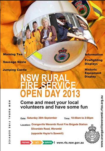
“At Richmond Road and Bennett Road at Windsor, the RFS (New South Wales Rural Fire Service) says a grassfire could impact properties around George Street and the area of Bligh Park. The fire has crossed Garfield Road and is burning in the Windsor Downs Nature Reserve.”
[Sources: ‘Home lost as grass fires rage in Marsden Park and Windsor‘, 20130910, Daily Telegraph newspaper, Sydney, ^http://www.dailytelegraph.com.au/newslocal/the-hills/home-lost-as-grass-fires-rage-in-marsden-park-and-windsor/story-fngr8i1f-1226716140957; ‘Two Homes under threat in Sydney grass fire‘, 20130910, Australian Broadcasting Corporation, ^http://www.abc.net.au/news/2013-09-10/two-homes-under-threat-in-sydney-grass-fire/4948314]
.
The fire authorities have labelled this current fire the ‘Richmond Road Grass Fire‘, so will the records of the fire will be just scattered or erased? Today’s initial account of the fire on the official Rural Fire Service website reads thus :
“..A grass fire burning in the area of Richmond Road and Bennett Road at Windsor”. The fire is burning on both sides of George Street, South Windsor and both sides of Richmond Road. The fire is burning under strong northerly winds. An Emergency Alert telephone message has been sent to residents in these areas.
There is the potential for the fire to impact on properties around George Street and the area of Bligh Park. The fire has crossed Richmond Road and is now burning in the Windsor Downs Nature Reserve.”
.
To put this into geographic perspective, this is a presumed map of the affected area, in absence of RFS public transparency:
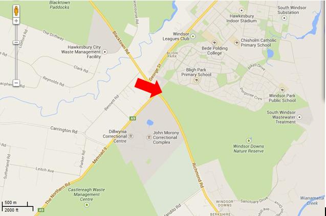
The presumed ignition of the Richmond Road Grass Fire
from Bennett Road, Windsor Downs
(outer north-western Sydney Metropolis)
[Source: Google Maps 2013]
.
<<Emergency warnings have now been issued for four bushfires in Sydney’s far north west, as temperatures in the city exceed 30 degrees with strong northerly winds.
The RFS says five firefighters have sustained smoke inhalation and two have received minor burns.
The fires are at Castlereagh, Richmond, Marsden Park, and Winmalee where one property is alight. At Richmond Road and Bennett Road at Windsor, RFS says a grassfire could impact properties around George Street and the area of Bligh Park. The fire has crossed Garfield Road and is burning in the Windsor Downs Nature Reserve. >>
.
[Ed: Garfield Road is in Riverstone, not Richmond, and is also quite distinct from the separate fire at Windsor Downs. Media reporting has been misleadingly false, overlapping and confused and likely due to naive junior desktop journalism. Worse is that the RFS report is equally confused. Fortunately no person died relying upon officialdom, but the wildlife count is never published].
.
.
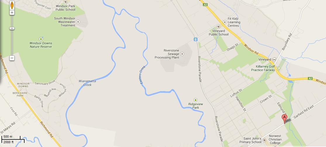 Map showing the juxtaposition of the Windsor Downs Nature Reserve over 3 km north west from Garfield Road in Riverstone.
Journalists have a lot to answer for when it comes to fact checking during emergencies.
[Source: Google Maps 2013, click image to enlarge]
Map showing the juxtaposition of the Windsor Downs Nature Reserve over 3 km north west from Garfield Road in Riverstone.
Journalists have a lot to answer for when it comes to fact checking during emergencies.
[Source: Google Maps 2013, click image to enlarge]
.
<< About 3,200 homes in the Richmond area have lost power and Endeavour Energy says it is working to get the supply back. The RFS says the fire is burning intensely under strong winds.
In Marsden Park, a grass fire is burning out of control and has crossed Garfield Road. While at Castlereagh, near Penrith, an emergency warning was issued around noon (AEST) for a fire which has destroyed a shed and burned 60 hectares. About 50 homes are thought to be under threat. The fire is burning around properties on Devlin Road and is moving towards homes on Nutt Road.
RFS Inspector Ben Shepherd says the conditions are difficult for firefighters.
RFS Inspector Ben Shepherd:
“I’m currently sitting on Nutt Road and the fire is moving quickly towards some homes in that area. The actual fire itself is putting up a huge column of smoke… and the wind continues to be quite strong. Because of that, that’s starting to send a couple of spot fires ahead of the main fire front itself.”
.
Local resident Kelly Elson has been evacuated from her home near the fire front. She says she first noticed the fire at about 10:30 this morning.
Windsor resident Troy Evans says that fire started in grass near his house on Bennett Road.
Windsor resident Troy Evans:
“So I went and told the firies ‘you better get a couple of trucks round here real quick’ which they did, luckily. They got the place under control then the wind turned and it’s just roared up through next door, jumped the road, it’s gone through the church, it’s over in the bus bay, it’s meant to have taken a couple of houses out in Bligh Park. Now it’s on it’s way into the jail, it’s just crazy.”
.
A very high fire danger alert has been issued for the Illawarra, Sydney, the Central Ranges, the Hunter, the north west and the north coast. More than 40 uncontained bushfires are currently burning across New South Wales.
Mr (RFS Commissioner Shane) Fitzsimmons says it is hot, dry and windy in most of the state today, with seven districts in very high fire danger. He says he is worried about the unseasonally warm start to spring on the back of a dry winter.
The RFS is urging property owners in semi-rural and rural areas to think about the conditions before they burn off land.”
.
[Ed: Fitzsimmons, why blame the weather and not the landholder who is accused of causing the ignition?]
.
[Source: ‘Homes under threat from bushfires at Castlereagh and Windsor in Sydney’s far north west’, 20130910, Australian Broadcasting Corporation, ^http://www.abc.net.au/news/2013-09-10/two-homes-under-threat-in-sydney-grass-fire/4948314]
.
[Ed: So the RFS is urging property owners in semi-rural and rural areas to think about the conditions before they burn off land.
Is this head office code for the known landholder who caused the fire and the RFS being too public servant skin timid to lay charges? So why is the landholder in Bennett Road not under arrest for suspected arson?]
.
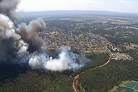
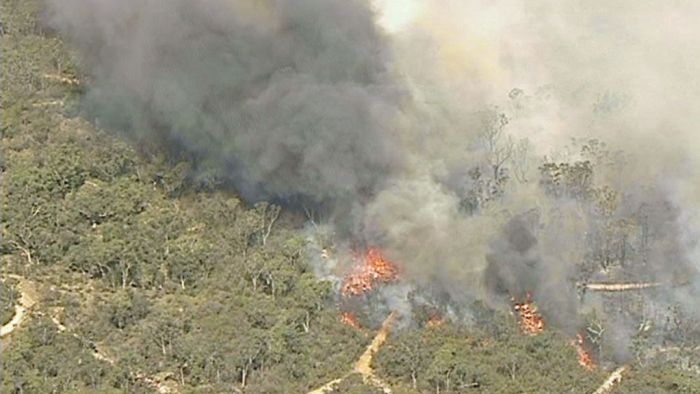
The fire inside the Windsor Downs Nature Reserve today
.
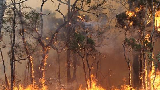 Windsor Downs native woodland habitat being burned alive
[Source: ‘Bushfires threaten Sydney’s western suburbs – NSW Rural Fire Service issues emergency warnings’, 20130910, Sydney Morning Herald newspaper (Sydney), ^http://www.smh.com.au/environment/bushfires-threaten-sydneys-western-suburbs-nsw-rural-fire-service-issues-emergency-warnings-20130910-2thnl.html] Windsor Downs native woodland habitat being burned alive
[Source: ‘Bushfires threaten Sydney’s western suburbs – NSW Rural Fire Service issues emergency warnings’, 20130910, Sydney Morning Herald newspaper (Sydney), ^http://www.smh.com.au/environment/bushfires-threaten-sydneys-western-suburbs-nsw-rural-fire-service-issues-emergency-warnings-20130910-2thnl.html]
.
.
 A liar bird of disinterested political masters A liar bird of disinterested political masters
.
http://www.youtube.com/watch?v=VktLOr4M46U
.
Cumberland Plain Woodland
.
Cumberland Plain Woodland including the Windsor Downs Nature Reserve, the nearby Castlereagh Nature Reserve and Agnes Banks Nature Reserve, all fall under the custodial management responsibility of the National Parks and Wildlife Service New South Wales – a state body.
Windsor Downs Nature Reserve features.. << an historic windmill and water tank protects a number of endangered plant communities and includes species such as the broad-leafed ironbark, grey box, scribbly gum, narrow-leafed angophora, pea flowers and a species of geebung.
Several bird species have been recorded – the red-capped and hooded robins, white-winged choughs, buff-rumped and yellow-tailed thornbills and the endangered regent honeyeater – which are usually found in the drier habitats of the central west slopes. >>
[Source: NSW Government, ^ http://www.environment.nsw.gov.au/NationalParks/parkHome.aspx?id=N0598]
.
Windsor Downs Nature Reserve is not just set aside for picnics. It is a remant ecological community with the fast disappearing Cumberland Plain Woodland. It is supposed to be protected.
.
<< The Cumberland Plain Woodland is the name for the distinct groupings of plants that occur on the clay soils derived from shale on the undulating Cumberland Plain in central New South Wales. The most commonly found trees in the woodland are Grey Box Eucalypts Eucalyptus moluccana, Forest Red Gums Eucalyptus tereticornis, Narrow-Leaved Ironbarks Eucalyptus crebra and Spotted Gum Eucalyptus maculata. A variety of other lesser-known eucalypts as well as shrubs, grasses and herbs are also found. It is the dominance of Grey Box and Forest Red Gum that makes the community distinctive.
In 1877 Cumberland Plain Woodland covered 107,000 hectares occupying approximately 30 per cent of the Sydney Basin. This community type was once widespread in the Plains but has been reduced to a few fragmented stands by human use for farming, industry and housing. Today less than six per cent remains in small fragments scattered across the western suburbs of Sydney, totalling only 6400 hectares. The remaining fragments occur in areas subject to intense pressure from urban development.
Although some areas occur within conservation reserves, this is in itself not sufficient to ensure the long-term survival of the community unless the factors threatening the integrity and survival of the community are eliminated.
The remaining stands of this ecological community are threatened by the spread of the Sydney suburban areas. Threats include clearance for agriculture, grazing, hobby and poultry farming, housing and other developments, invasion by exotic plants and increased nutrient loads due to fertiliser run-off from gardens and farmland, dumped refuse or sewer discharge.>>
[Ed: and of course ‘bushfire’, which the government does not like to include out of embarassment of neglect, yet which is causes the most devastating impact].
.
[Source: ‘Woodlands vanishing from Sydney’s outskirts’, by Environment Australia, Australian Government, ^http://www.environment.gov.au/biodiversity/threatened/publications/cumberland.html]
.
Cumberland Plain Woodland in the Sydney Basin Bioregion – proposed critically endangered ecological community listing
.
<< The NSW Scientific Committee, established by the Threatened Species Conservation Act, has made a Preliminary Determination to support a proposal to list the Cumberland Plain Woodland in the Sydney Basin Bioregion as a CRITICALLY ENDANGERED ECOLOGICAL COMMUNITY on Part 2 of Schedule 1A of the Act and as a consequence, to omit reference to Cumberland Plain Woodland from Part 3 of Schedule 1 (Endangered Ecological Communities) of the Act. The listing of Critically Endangered Ecological Communities is provided for by Part 2 of the Act.
The Scientific Committee has found that:
1. Cumberland Plain Woodland was listed as an Endangered Ecological Community under the Threatened Species Conservation Act 1995 in June 1997 (NSW Scientific Committee 1997). Since this listing, a large volume of new data and analyses have become available. In addition, a nomination to change the status of Cumberland Woodland to Critically Endangered status has been received. This Determination addresses additional information now available in accordance with current listing criteria under the Threatened Species Conservation Regulation 2002.
2. Cumberland Plain Woodland is the name given to the ecological community in the Sydney Basin bioregion associated with clay soils derived from Wianamatta Group geology, or more rarely alluvial substrates, on the Cumberland Plain, a rainshadow area to the west of Sydney’s Central Business District. >>
<<..high frequencies of fires may result where fragmentation increases the interface between urban areas and bushland, as this results in increased arson, car dumping, planned fuel-reduction fires and accidental ignitions.
High fire frequencies are associated with reduced diversity of native plant species in Cumberland Plain Woodland (Watson 2005). ‘High frequency fire resulting in disruption of life cycle processes in plants and animals and loss of vegetation structure and composition’ is listed as a Key Threatening Process under the Threatened Species Conservation Act 1995.
The season of fire, which may be altered as a consequence of hazard reduction fires, may also influence the species composition of the grassy woodland understorey (Knox & Clarke 2006; Benson & von Richter 2008).
Disruption of ecological processes associated with alteration of fire regimes contributes to a very large reduction in ecological function of the community. >>
.
[Source: ‘NSW Scientific Committee – preliminary determination’, Australian Government, ^http://www.environment.nsw.gov.au/determinations/cumberlandplainpd.htm]
.
But wait, there is a:
which reads…

.
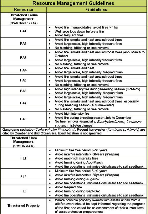
The official Fire Management Strategy has been conveniently removed from public access on the National Parks and Wildlife Service (NPWS) website.
However, the following extracts from the similar and nearby Agnes Banks Nature Reserve are instructive as to the approach taken by NPWS management on all nature reserves across the Sydney Basin that comprise remnant ecology of the Cumberland Plain Woodland.
.
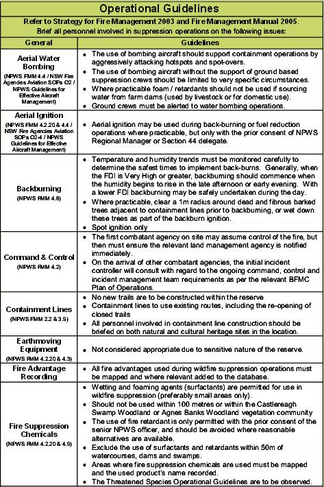
.
Source: ‘Agnes Banks Nature Reserve Fire Management Strategy, 2006, (last modified 20070323), NPWS (NSW), NSW Government, ^http://www.environment.nsw.gov.au/resources/parks/06354AgnesBanksFMS.pdf]
.
[Ed: Disturbingly noted is that the NPWS ‘ecological’ policy is that it ok to burn these woodland reserves every 8 years. So government care factor about bushfire impact?]
.
<<..little research has been undertaken into fire management prescriptions for Cumberland Plain woodland and forest associations when compared to the nearby Hawkesbury sandstone communities.>>
~ Windsor Downs Nature Reserve et al. Plan of Management (NPWS 1999,p.18)
.
The official Bureau of Meteorology had in the days prior, forecast strong gusty north westerly winds for the western Sydney region for both yesterday and today, following a few days of calm winds. The Rural Fire Service would have been well aware of this forecast, the extreme bushfire conditions that this posed and the considerable escalated risk of damaging wildlfires.
The subsequent actual weather observations for Richmond are telling. Look at the 10th. The arsonists know what they are doing.
.
 [Source: Australian Bureau of Meteorology,
^http://www.bom.gov.au/climate/dwo/201309/html/IDCJDW2119.201309.shtml] [Source: Australian Bureau of Meteorology,
^http://www.bom.gov.au/climate/dwo/201309/html/IDCJDW2119.201309.shtml]
.
Reliant mainly on public calls to ‘000’, fire trucks and road-routed volunteers, the RFS continues to be grossly under-equipped to handle wildlfires in a timely and effective manner, which increasingly to many is unacceptable to bushfire prone communities in this now 21st Century.
.
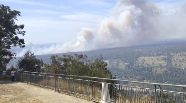 Windsor Downs Nature Reserve ablaze (from Hawkesbury Lookout) Windsor Downs Nature Reserve ablaze (from Hawkesbury Lookout)
[Source: ‘Hazard reduction burn started major Sydney bushfire’, by Megan Levy, Sydney Morning Herald, 20130913,
^http://www.smh.com.au/nsw/hazard-reduction-burn-started-major-sydney-bushfire-20130913-2tois.html]
.
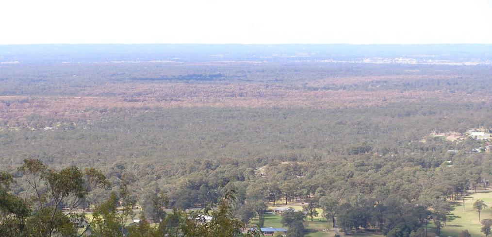 Windsor Downs Nature Reserve incinerated (see browned woodland canopy in centre of photograph)
[Photo taken by Editor from Hawkesbury Lookout looking north east on 20130921, photo © under ^Creative Commons]
Click image to enlarge Windsor Downs Nature Reserve incinerated (see browned woodland canopy in centre of photograph)
[Photo taken by Editor from Hawkesbury Lookout looking north east on 20130921, photo © under ^Creative Commons]
Click image to enlarge
.
Steadily year on year, the last bushland reserves that provide critical remnant habitat around Sydney are being destroyed. Before long the only bushland will be that in suburban gardens, and the wildlife will be finally made regionally extinct.
.
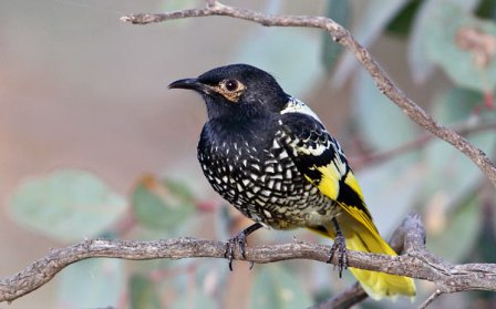 Critically Endangered Regent Honeyeater
(Anthochaera phrygia)
A native bird species dependant upon a disappearing habitat
Humans obliterated its habitat for logging, farming and housing
Then we constrained it to a few nature reserves like Windsor Downs,
Then we burnt the reserve. Critically Endangered Regent Honeyeater
(Anthochaera phrygia)
A native bird species dependant upon a disappearing habitat
Humans obliterated its habitat for logging, farming and housing
Then we constrained it to a few nature reserves like Windsor Downs,
Then we burnt the reserve.
.
.
.
Further Reading:
.
[1] ‘NSW Scientific Committee – preliminary determination‘, Australian Government, ^http://www.environment.nsw.gov.au/determinations/cumberlandplainpd.htm
.
[2] ‘Castlereagh, Agnes Banks and Windsor Downs Nature Reserves – Plan of Management‘, NSW Government, ^http://www.environment.nsw.gov.au/resources/parks/pomfinalagnescastlereagh.pdf
.
Footnote
.
‘Hunt for arsonist over western Sydney bushfire’
[Source: ‘Hunt for arsonist over western Sydney bushfire’, Friday 20130913, ABC, ^http://www.abc.net.au/news/2013-09-13/hunt-for-arsonist-over-western-sydney-bushfire/4956022]
.
<<Authorities say they believe a fire that destroyed a home at Marsden Park in Sydney’s west on Tuesday was deliberately lit. Investigators have also not ruled out that an arsonist may have caused a blaze at nearby Londonderry. Police are now calling for witnesses to help identify the person responsible for sparking the Marsden Park fire.
Assistant Commissioner Alan Clarke says it is believed the fire began on Grange Avenue just after midday on Tuesday.
.
Alan Clarke:
.
“There are crime scene indicators at the source of that fire that would lead us to suspect arson activity. I really can’t tell you more than that at the moment. It’s mainly our crime scene indicators and forensic evidence that would have us raise that suspicion. If anyone has information, if anyone saw any suspicious activity in or around that fire location, any part of it… please pass that information on for the benefit of police.”
.
Rural Fire Service Deputy Commissioner Rob Rogers has confirmed another serious fire at Winmalee, in the lower Blue Mountains, was caused by a hazard reduction burn conducted by the NSW National Parks and Wildlife Service.
.
Rob Rogers:
“That fire was burn on the weekend, it was patrolled on Monday, there was smouldering activity. That fire then jumped containment lines on the Tuesday and became an active fire. The winds on that day did exceed forecast and they were around 90 kilometres an hour, and obviously that tested the control lines on that hazard reduction and it did escape. In these strong winds branches came off trees, hit the powerlines, the powerlines were brought down, they ignited grass in that area and that was the cause of that fire. You would have to obviously be suspicious that it did come from the hazard reduction, given that it was in a very close proximity to it.”
.
Investigators have found a fourth fire that began on Richmond Road at Windsor Downs was sparked by downed power lines. The investigation into a fire that closed the M1 motorway, formerly known as the F3, north of Sydney yesterday is continuing, with another hazard reduction burn the suspected cause. Assistant Commissioner Alan Clarke has warned those that deliberately light fires or cause them through negligence will be caught.
.
Alan Clarke:
“Last year we arrested 87 individuals and they faced charges in respect of bushfire and fire related activity for 117 charges. We know this year again we will be putting offenders before the court. It’s sad but it’s true.”
.
Tags: A liar bird of disinterested political masters, Agnes Banks Nature Reserve, Castlereagh Nature Reserve, Cumberland Plain Woodland, Hawkesbury Road Winmalee Fire, Marsden Park Fire, NPWS, NSW Fire Brigade, NSW National Parks and Wildlife Service, Retained Firefighter, Richmond Road Grass Fire, Rural Fire Starters, Windsor Downs Nature Reserve
Posted in Birds (Australian), Critically Endangered Wildlife (CR), Threats from Bushfire | No Comments »
Add this post to Del.icio.us - Digg
|
|