by Editor 20100907.
The 2006 Grose Fire that devastated the protected Grose Valley and iconic Blue Gum Forest in November of that year was initially referred to as the ‘Burra Korain Fire‘ by the fire authorities because that was the initial localised bushfire at the time. The first ignition purportedly started by a lightning strike near Burra Korain Head, which is a bluff situated about 4km east of the village of Mount Victoria inside the Blue Mountains National Park, west of Sydney. The head is situated at the northern end of the prominent Burra Korain Ridge above the western side of the Grose Valley. [Ref: Topographic Map ‘Mt Wilson 8930-1N’ grid reference GR 498815 – per RFS official Section 44 Report].
A second ignition purportedly took place north west of Mount Victoria, south of the village of Hartley Vale was referred to as the ‘Lawson’s Long Alley Fire‘. Defensive backburning operatings in Hartley Vale, along the Bells Line of Road and along the Blackheath escarpment then got out of control, winds picked up and the multiple fires conflagrated into a massive fire storm on Wednesday 22nd November 2006.

Burnt Grose Valley 9-Dec-06.
[©Photo by Editor, free on Public Domain – click to enlarge].
The following are extracts of successive media releases by the Blue Mountains Fire Control RFS NSW R ural Fire Service, Emergency Services Centre, Cnr Bathurst Rd & Valley Rd, KATOOMBA. RFS advice about health and instructions to residents have not been included, since these sections are generic and repeated in each media release. [Source: http://lists.rfs.org.au/mailman/listinfo/bluemountains-info]. It is instructive to compare and contrast the media releases of each day with the Day by Day Synopsis (pages 6 – 11) in the official Report on Lawson’s Long Alley Section 44. Read Report: Lawsons Long Alley Section 44 Report 20070208.pdf.
Thursday 16-Nov-06:
Fire Name: Lawsons Long Alley
Time Message Issued: 1700
Date Message Issued: 16/11/06
Two bushfires that were believed to have been started by lightning strikes on Monday are burning in the Blue Mountains National Park. A fire burning 2 km north of Mount Victoria has burnt out about 1100 hectares of private property and parkland and is burning on both sides of the Darling Causeway. The Darling Causeway remains closed to traffic and motorists are advised to use the Great Western Highway and Bells Line of Road as alternate routes.
A second fire burning about 5 km north of Blackheath in the Grose Valley has burnt out about 500 hectares of parkland. Waterbombing aircraft are slowing the progress of the fire as it is burning in difficult and inaccessible terrain.
The fire is not threatening any properties or homes at this stage.
All walking tracks into the Grose Valley are closed but cliff top tracks remain open. Hat Hill Road, Victoria Falls Road and Pierces Pass are currently closed within the Grose Valley.
Strategy
About 160 firefighters and ten waterbombing aircraft are working to contain the fires. Backburning operations have taken place north of Mt Victoria around St Georges Parade and the Darling Causeway.
.
Friday 17-Nov-06:
")
“Around 70 NSW Rural Fire Service (RFS), NSW Fire Brigades (NSWFB) and National Parks and Wildlife Service (NPWS) personnel will today join the dedicated volunteer firefighters of the Blue Mountains as they continue to work on two fires burning in the Grose Valley in the upper Mountains.
Dubbed the “Lawsons Long Alley Fire”, the main fire started on Tuesday afternoon near Hartley Vale, in the Lithgow District, and quickly spread up to the Darling Causeway – blown by strong westerly winds – and has now burned out around 1,370 hectares. A second fire, known as “Burra Korain Fire” is burning to the north of Blackheath and covering an area of approximately 100 hectares.
Fire conditions today are expected to remain in the firefighters’ favour, with continued low temperatures and light, variable winds. No properties or homes are currently under threat by the fire, however large volumes of smoke are visible throughout the Mountains and some parts of the Sydney basin and there has been some impact on local roads.
Assisting the local firefighters are other committed volunteers from Lithgow and Hornsby, with NPWS supplying specialist Remote Area Firefighting Teams (RAFT) to effect containment strategies. Eleven aircraft, including two large Skycranes, will again work vigorously to hinder the fire’s progression to allow the preparation and implementation of control lines.
Whilst today’s weather conditions remain relatively benign, information from the Weather Bureau indicates warmer temperatures ahead, under a north-westerly influence. Firefighting strategies have been developed in anticipation of these conditions and increased preparation is being undertaken. The Darling Causeway remains closed to all traffic between Mt Victoria and Bell. Motorists are advised to use the Great Western Highway or Bells Line of Road as alternate routes. Mt York Road also remains closed west of the Lockyers Road Track.
From today, the NSW Rural Fire Service will be undertaking public information sessions with communities in the communities surrounding the areas affected by the fire in an effort to ensure a well-informed and well-prepared community.
The Blue Mountains is a major tourist attraction and members of the public are advised that although a fire is currently burning in the upper Grose Valley, all walks, attractions and tourist facilities remain open and operating as normal east of Blackheath.”
.
Saturday 18-Nov-06:
RFS media release:
“Two bushfires that were believed to have been started by lightning strikes on Monday are burning in the Blue Mountains National Park. A fire burning 2 km north of Mount Victoria is largely contained and has burnt out about 1100 hectares of private property and parkland and is burning on both sides of the Darling Causeway. The Darling Causeway remains closed to traffic and motorists are advised to use the Great Western Highway and Bells Line of Road as alternate routes.
A second fire burning about 5 km north of Blackheath in the Grose Valley has burnt out about 600 hectares of parkland. Waterbombing aircraft are slowing the progress of the fire as it is burning in difficult and inaccessible terrain.”
So Saturday morning the main bushfire threat was from the Burra Korain Fire’. The fire management strategy at this time according to the RFS community newsletter issued by the Incident Management Team on behalf of the Commissioner of the NSW Rural Fire Service was as follows:
“A review of containment strategies has been undertaken overnight with forecasts provided from the Bureau of
Meteorology. Today fire crews will recommence direct attack of the fire where accessible, supported by
extensive water bombing. At the same time preparation of control lines will commence on the northern boundary
of Blackheath. After further information from the Bureau of Meteorology, and assessment of the fire progression,
and containment achieved as a result of the direct attack, backburning may commence along the Blackheath
control lines in the evening and through to Sunday. Residents are advised to ensure that all windows and doors
are closed and rear of the properties clear should this option be undertaken.”
At 1300hrs the RFS ’Bushfire Update read:
“A review of containment strategies has been undertaken and this afternoon extra resources the greater Sydney area will be brought in to undertake extensive backburning operations. Crews from the RFS and NSWFB will be burning behind properties between MT Victoria and Blackheath. This operation will continue through the night and into Sunday.”
Monday 20-Nov-06:
At 1100hrs the RFS ’Community Newsletter’ read:
About 250 firefighters have progressed well with the second stage of backburning operations along The Bells
Line of Road between the Darling Causeway at Bell to Mount Tomah. Crews have completed backburning from
the Bells Line of Road during the evening and will continue working on backburning towards Pierces Pass
Picnic Area. The fire is not contained at this stage.
Crews from the RFS NSW Fire Brigades and National Parks and Wildlife Service will be mopping up and will
continue to work on containment lines throughout the day and overnight. Due to the increased amount of fire in
the valley between The Bells Line of Road, Blackheath and Mt Victoria residents are advised to take appropriate
precautions if smoke or ash affect their properties._
Around 50 RFS and National Parks and Wildlife Service remote area firefighters and 16 aircraft will continue to
work on inaccessible parts of the fire in the Grose Valley today. The Bells Line of Road remains closed due to fire operations and falling trees.
Strategy
Crews will continue to work on the northern, western and southern boundaries of the fire today. The eastern
edge of the fire is burning in inaccessible terrain and remote area firefighters will be winched in to work on fire
breaks. Aircraft will continue to water bomb the eastern edge in anticipation of worsening weather conditions on
Tuesday and Wednesday. Firefighting operations will focus on the eastern edge today and overnight.”
Ed: So now the fire is in the Grose Valley…
Tuesday 21-Nov-06:
Blue Mountains Fire Update – 11.00am
“The fire in the Blue Mountains breached containment lines overnight on the northern end of Hat Hill Road at Anvil Rock. Firefighters worked hard overnight to hold the eastern containment line but strong westerly winds and dry conditions hindered operations and the fire was unable to be held on that edge. Containment lines in the north, west and south continue to hold and these are not expected to be tested today.
About 400 firefighters from the RFS, National Parks and Wildlife Service and NSW Fire Brigades and 18 aircraft will work to slow the spread of the fire in preparation for worsening weather conditions today and tomorrow.
Blue Mountains residents to the north-east, east and south-east of the fire should prepare their properties for fire and ensure they have a plan to stay or relocate early if the fire reaches their area.
The Bells Line of Road remains closed due to fire operations and falling trees. The Blue Mountains National Park will remain closed until further notice.
Crews will continue to work on containment strategies in preparation worsening weather conditions today and tomorrow. Aircraft will work to slow the progress of the eastern edge of the fire and will work on any new fire outbreaks ahead of the fire. The eastern edge of the fire is burning in inaccessible terrain but will continue to burn in difficult country until weather conditions improve. “
Weather Forecast
Tuesday: 32 degrees with strong hot winds from the W/NW gusting up to 50 km/h and humidity at a low of 10%. Wind changing to WNW overnight up to 80 km/h A Total Fire Ban is in place until midnight Tuesday night.
Wednesday: Fine, hot north westerly winds gusting up to 50 km/h in the day. Very high to extreme fire danger expected.
Many tourist attractions in the Blue Mountains and Lithgow remain open but the Blue Mountains National Park is closed. Hat Hill Road, Ridgewell Road, Victoria Falls Road, Pierces Pass and Mt Banks Road remain closed.
Blue Mountains Fire Update 5am:
“The 6800ha fire in the Blue Mountains National Park escaped in the eastern section earlier this evening, confirming concerns the fire will be difficult to control in extreme fire conditions over coming days. The fire is not directly threatening property at this time but there are concerns that strong westerly winds could cause property issues over the next 72 hours.
The fire escaped near Anvil Rock. Crews were already concentrated in this area to work on containment lines and nine more fire tankers were responded when the escape occurred at about 11pm. Firefighters tried to hold the fire at Perrys Track but difficult terrain and fire behaviour meant this was not possible.
Aerial reconnaissance will be undertaken at first light to identify the spread of the fire and direct waterbombing aircraft to help limit the spread of the escape. While there is a chance firefighters can steady spread through waterbombing, strong westerly winds are forecast for today and continuing difficult weather conditions are predicted for the rest of the week. This could cause the fire to run. About 400 firefighters will continue to work on the fire today.
The two bushfires which have been burning in the Blue Mountains National Park for the past nine days have joined and are being treated as one fireground. The fire is in an area surrounded by the Great Western Hwy, Darling Causeway, Bells Line of Road. The Bells Line of Road will be closed between the Darling Causeway and Mount Tomah until further notice.”
Wednesday 22-Nov-06:
“Crews from the Rural Fire Service were unable to complete back burning operations to consolidate containment along the Mount Banks Fire trail, east of the fire, due to erratic fire behaviour and some spot-overs from the fire have moved into the Banks Ridge area, running predominately in an easterly direction. As a precautionary measure, a strike team comprising of NSWFB and RFS crews has been deployed to the south west of Mount Tomah to provide patrolling and observation of the fire and possible asset protection if required. All Blue Mountains residents to the north-east, east and south-east of the fire should prepare their properties for fire and ensure they have a plan to stay and defend their property, or relocate early if the fire reaches their area.
The Bells Line of Road between the Darling Causeway and Mount Tomah remains closed due to fire operations and falling trees. All areas of Blue Mountains National Park will remain closed until further notice and the Mount Tomah Botanical Gardens will also be closed today. The Great Western Highway and the Darling Causeway are open, however smoke may reduce visibility in some areas and drivers are asked to proceed with caution.”
Strategy
“Crews will continue to work on containment strategies in preparation for worsening weather conditions and aircraft will continue to slow the progress of the eastern edge of the fire and work on any new fire outbreaks ahead of the fire front. The eastern edge of the fire is still burning in inaccessible terrain towards King Georges Brook and is expected to continue to burn in difficult country until weather conditions improve. ”
Weather Forecast
Today: Fine, hot north westerly winds gusting up to 70 km/h in the day. Very high to extreme fire danger expected.
Thursday: Warm fine weather, winds easing.
Authorized By: Mal Cronstedt – Incident Controller
Communiqué at 1100 hrs:
“The fire in the Blue Mountains National Park continues to burn in an easterly direction and has been active in the Anvil Rock area where helicopters are waterbombing and is not affecting properties at this time. There are 400 firefighters and 15 aircraft working on the fire which is not contained and conditions are expected to be difficult today.
RFS crews attempted to consolidate containment to the east overnight by conducting a back burn along the Mount Banks Fire Trail. The crews experienced some erratic fire behaviour and the fire has spotted over to the east overnight and is progressing in the Explorers Ranges and Banks Ridge areas.
A NSWFB strike team has been deployed to Mount Tomah to the north east of the fire, as a precautionary measure, to patrol fire progress and provide possible asset protection, if required.
The fire is about 5km southwest of Mt Tomah and 5km from Blackheath and is about 14500ha. Containment lines in the north, west and south continue to hold and are being patrolled.
The fire is not directly threatening properties at this time but difficult winds and hot weather are expected to challenge firefighters today.”
Weather Forecast
Today: Fine, hot north westerly winds gusting up to 70 km/h in the day. Very high to extreme fire danger expected.
Thursday: Warm fine weather, winds easing.”
Blue Mountains Fire Update 2pm:
“The fire in the Blue Mountains National Park is experiencing very strong winds causing two spot fires due to increased fire activity in the Banks Mountain area. Helicopters are waterbombing the spotfires. While it is not affecting properties at this time there are concerns as fire activity increases.
The two spotfires are north of the Woodford Dam, one is 5km north of Linden and the other 5km north of Hazelbrook. A NSWFB strike team has been deployed to Mount Tomah to the north east of the fire, as a precautionary measure, to patrol fire progress and provide possible asset protection, if required. Firefighters are also deployed to Blackheath in Hat Hill Rd.
There are 400 firefighters and 15 aircraft working on the fire which is not contained with strong winds of 50kph gusting at times to 90kph from variable directions but generally northwest. This has caused the fire to spot ahead of itself to the southeast. The spot fires are …
The fire is about 5km southwest of Mt Tomah and 5km from Blackheath and is about 14500ha. Containment lines in the north, west and south continue to hold and are being patrolled.”
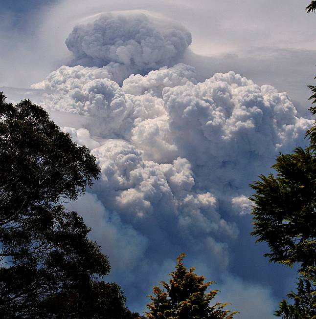
 Pyrocumulus cloud over the Grose Valley Wednesday afternoon 22-Nov-06. [©Photo blackheath weather.com http://www.blackheathweather.com/summer2006/fire22-11-06-003a.jpg – click to enlarge].
Spotfire update 2.24pm – Blue Mountains Fire:
“Aerial Observation units had reported two spotfires to the north of Hazelbrook and the Woodford Dam.
NSW Rural Fire Service and NSW Fire Brigades crews were immediately responded to the area along with waterbombing aircraft.
One of the spotfires has now been brought under control and the second spotfire is currently being held by waterbombing operations.”
Blue Mountains Fire – 4.30pm Update Wednesday:
“The fire in the Blue Mountains National Park is experiencing very strong winds which had caused two spot fires due to increased fire activity in the Banks Mountain area. Helicopters were used to waterbomb the spotfires. They are believed to have contained one spotfire and are bringing the other under control.
The spotfire believed to be contained is about 4km north of Lake Woodford, the other is 5km north of Hazelbrook and helicopters are currently waterbombing to slow its progression. A number of NSW Rural Fire Service (RFS) and NSW Fire Brigades (NSWFB) units were responded to the surrounding areas to ascertain the location and spread of the spotfires.
All aircraft assigned to this fire are currently in use waterbombing the fire which has been moving steadily east.
A NSWFB strike team has been deployed to Mount Tomah to the north east of the fire, as a precautionary measure, to patrol fire progress and provide possible asset protection, if required. Firefighters are also deployed to Blackheath in Hat Hill Rd.
Throughout the day 400 firefighters and 15 aircraft have been working on the fire which is not contained with strong winds of 50kph gusting at times to 90kph from variable directions but generally northwest. This has caused the fire to spot ahead of itself to the southeast.
The fire is about 5km southwest of Mt Tomah and 5km from Blackheath and is about 14500ha. Containment lines in the north, west and south continue to hold and are being patrolled.
Residents of the Blue Mountains who reside to the north, northeast and southeast of the fire are advised to prepare their properties for fire and ensure they have a plan to either stay and defend or relocate early if fire reaches their area.
The Bells Line of Road is closed between the Darling Causeway and Mount Tomah, due to fire operations and falling trees. All areas of Blue Mountains National Park will remain closed until further notice. Park closure enquiries can be made to Blackheath Heritage Centre on (02) 4787 8877.
Predicted weather: Temp: 30 degrees Winds: Primarily northwest 45kph gusting higher Humidity: 13%.”
Blue Mountains Fire 7.15pm update:
“Strong winds and high temperatures that drove the Blue Mountains fire have eased this evening allowing for about 500 NSW Rural Fire Service (RFS), NSW Fire Brigades (NSWFB) and National Parks and Wildlife Service (NPWS) firefighters to prepare for backburning operations this evening.
Crews will commence backburning east along the Bells Line of Road all the way to Mount Tomah then progress from Mount Tomah to Mount Banks. Backburning operations are also planned along fire trails between Hat Hill Road and Mount Hay Road behind Leura. This operation will continue along Mount Hay Road to Mount Hay.
A west-south-west influence is expected in the evening but may not reach the northern edges of the fire through the Grose Valley. Weather over the coming days is predicted to be cooler and should see winds easing, allowing for calmer conditions for firefighters. Unpredictable fire behaviour, driven by strong erratic winds has so far made it very difficult for firefighters to contain.
Two spotfires occurred during the day about 6.5km North West of Faulconbridge. Aircraft were able to successfully extinguish one spot fire to the north of Lake Woodford. Aircraft have slowed the progress of the second spotfire and will continue to work on slowing its progress.
Residents of the Blue Mountains who reside to the north, northeast and southeast of the fire are advised to prepare their properties for fire and ensure they have a plan to either stay and defend or relocate early if fire reaches their area.
The Bells Line of Road is closed between the Darling Causeway and Mount Tomah, due to continuing fire operations and falling trees. All areas of Blue Mountains National Park will remain closed until further notice.”
Thursday 23-Nov-06:
Bushfire Update:
“High winds and temperatures provided momentum for the fire to take runs to the east and significant spotting occurred several kilometres from the main fire front yesterday afternoon. As a result, five strike teams were deployed to the townships of Linden and Falconbridge as a precautionary measure for any significant wind changes. By mid afternoon, over 500 crews comprising of RFS, NPWS and NSWFB were deployed for possible property protection and patrolling and 15 aircraft were successful in extinguishing one spot fire and significantly hindering the progress of the other spot fire. These two fire sites continue to be monitored today by water-bombing aircraft and Remote Area Fire Team (RAFT) crews.
During the night as winds eased and temperatures dropped, crews were successful in consolidating containment through back burning along the southern side of Bells Line of Road towards Mount Tomah and also east of Blackheath, along Hat Hill Road and these works will continue through today and tonight. Reports of another small unrelated fire to the north of the main fire along Queen Victoria Pass, at Mount Victoria was received around midnight. Crews were responded to this and were able to contain this fire that had dropped over the edge from Queen Victoria Pass.
The Bells Line of Road between the Darling Causeway and Mount Tomah remains closed, due to fire operations and falling trees. All areas of Blue Mountains National Park will remain closed until further notice.
Strategy
Crews will continue to monitor the fire’s progress through Mt Banks Ridgeline and work towards full containment. It is anticipated that the fire will continue to burn in inaccessible terrain, until significant weather or rain influence its direction and intensity.
Weather Forecast
Today: Fine, warm with winds tending south, south-west, gusting up to 40 km/h in the day. High to Very high fire danger expected.
Friday: Warm fine weather, winds still easing.”
Bushfire Update 1330hrs 23-Nov-06:
“Firefighters are continuing to conduct backburning work around Mt Tomah and along fire trails from Blackheath towards Evans Lookout, as they try to contain the fire in the Blue Mountains. Backburning is progressing well with weather conditions assisting firefighters at this stage.”
Mount Tomah/Blackheath
“Crews are backburning along the Bells Line of Road all the way to Mount Tomah. They will then progress from Mount Tomah to Mount Banks. Crews are also backburning from Pulpit Rock Rd to Evans Lookout Rd Blackheath. Backburning operations are along fire trails between Hat Hill Road and Mount Hay Road behind Leura. This operation will continue along Mount Hay Road to Mount Hay.
Two spotfires occurred during yesterday afternoon 6.5km northwest of Faulconbridge. Aircraft were able to successfully extinguish one spot fire to the north of Lake Woodford. Aircraft have slowed the progress of the second spotfire which is 60ha and will continue operations today.
The fire is not contained and active fire is burning 2.5km south of Mt Tomah and 7km north of Wentworth Falls and has burnt 12500ha.”
Mitchell’s Lookout ( Queen Victoria Pass)
“Another unrelated fire was reported at midnight along Queen Victoria Pass in the vicinity of Mitchells Lookout, north of Mt Victoria. Crews were responded and have contained the fire on top of the cliff and over the cliff edge. Over 300 personnel will work on the fire today with further crews available for response. Crews are from NSW Rural Fire Service (RFS), NSW Fire Brigades (NSWFB) and National Parks and Wildlife Service (NPWS).”
Weather Conditions
Weather conditions today are predicted to include temperatures of 27 degrees, winds from the west southwest of 25kph gusting to 45kph and relative humidity of 17 percent. Current weather at Mt Boyce is around 25 degrees, with westerly winds 19kph to 28kph and humidity of 18 percent. Winds over the coming 12 hours indicates a wind shift to a south westerly influence with a decline in wind speed. This predict Blue Mountains who reside to the north, northeast and southeast of the fire are advised to prepare their properties for fire and ensure they have a plan to either stay and defend or relocate early if fire reaches their area.”
Friday 24-Nov-06:
[Bluemountains-info] Blue Mountains Fire Update- 5 am Friday
Mount Tomah/Blackheath
“Late last night both temperature and winds dropped and light misty rain fell over the area of operations, hindering progress on backburning and forcing crews to black-out any active back-burn edges. Partial burns were achieved to the north of Falconbridge and along Hat Hill road. Some backburning continued at Mount Tomah and along the southern edge of Bells Line of Road, to contain the fire south of Bells Line of road with the assistance of crews from Hawkesbury Fire District. Strike teams from NSWFB and RFS were all assisting with the back burning operation last night and this morning, until weather conditions no longer made this feasible.
The main fire still remains active, with a line scan planned this morning, subject to visibility and from this, planned containment consolidation options will be re-assessed today.
Mt Victoria
The Mitchells Lookout Fire is blacked out and will be periodically checked for possible re-ignition, should weather conditions change significantly. Residents are reminded to call Crime-Stoppers if they see any suspicious activity by calling 1800 333 000.
Weather
Weather predictions indicate winds continuing with an easterly influence tending north and easing. The easterly influence will also bring in an increase relative humidity, which will allow for the back burning to continue safely, provided no further light rain falls. Saturday is predicted to have increased temperatures and winds tending north, northwest with Sunday expecting 30 degree temperatures and easterly winds.” – Inspector Eric J Berry JP (RFS, Katoomba)
Bushfire Update Friday 24 November 2006
“Last night and early this morning, crews from NSW RFS, NSWFB and NPWS continued back-burning operations overnight, north of Falconbridge, along hat Hill road and south of Bells Line of road towards Mt Tomah, until light rains hampered progress. Some burning was achieved, but with the weather conditions generally success was limited .The fire continues to remain along the Dawes Ridge, Lawson Ridge and Carmarthen Ridge, under the influence of light north easterly wind.
A small fire reported late yesterday evening at Mitchells Lookout, Mount Victoria was extinguished yesterday and is being monitored for possible re-ignitions. The cause of this fire is under investigation and residents are reminded that a Crime Stoppers hotline is available for reports of all suspicious activity by calling 1800 333 000.
Strategy
Crews will continue to work on containment strategies along existing containment lines with back burning being considered, should weather conditions allow, in preparation worsening weather conditions which are expected on Sunday and Monday and aircraft will continue to slow the progress of the eastern edge of the fire and continue work on any new fire outbreaks ahead of the fire front.
Weather Forecast
Today: Fine, warm with easterly winds tending north-easterly in the afternoon gusting up to 22 km/h. High fire danger expected.
Saturday: Warm weather with temperatures expected to reach 30 degrees with winds tending north westerly.
Saturday 25-Nov-06:
[Bluemountains-info] Blue Mountains Fire Update Saturday 8pm
“Back burning has recommenced from Medlow Bath to Point Pilcher this afternoon, and will continue as long as is viable into the night. The Bells Line of Road has also now been re-opened in all directions.
Ground and remote area fire crews were today deployed to Hurley Heights and Lawson Ridge for a direct attack. Dozer lines have also been established in order to provide tanker access and support for the Remote Area Fire crews. Crews have completed mopping up along Bells Line of Road and the western side of Mt Tomah.
Current Strategy
“Work is continuing on improving the existing fire trails adjacent to properties in the Berambing/Bilpin area in preparation for back burning operations if fire crosses Tomah Creek or the Grose River.
A back burn in the base of the Grose Valley may be visible to residents of Yarramundi, Grose Vale, Bowen Mountain and Grose Wold. Residents are advised not to be alarmed as this consolidation work is being carried out.
Road Closures
The Bells Line of Road is now open.
All areas of Blue Mountains National Park will remain closed until further notice.
Weather Forecast
Sunday : Fine. Warm. Light winds.
Monday 27-Nov-06:
COMMUNITY NEWSLETTER
Bushfire Situation 0600 hrs
[Issued by the Incident Management Team on behalf of the Commissioner of the NSW Rural Fire Service]
“Mild conditions continued overnight, with minimal fire activity current across the fireground. Mild easterly weather conditions predicted today are likely to minimise the threat of fires affecting property. However if conditions tend to westerly winds with lower humidity, re-ignitions could threaten contained edges.
Backburning up to 100m deep around the western side of Mt Tomah is complete with all edges inactive. The main front is generally inactive but is within 2 to 3km SW of Mount Tomah/Berambing. The Dawes Ridge spotfire has been effectively suppressed by heli-bucketting. Backburning reached Grand Canyon Road with minimal depth due to very low fuels. Mt Hay edges are inactive in very low fuels.
The Bells Line of Road between the Darling Causeway and Mount Tomah has been re-opened, however, residents and visitors are advised that Mount Banks and Pierces Pass trails / tracks are closed to the public. Visitors and residents travelling along Bells Line of Road are advised that whilst the road has been re-opened, it may be closed intermittently due to fire operations. The Great Western Highway and the Darling Causeway remain open, however, as previously advised, smoke may reduce visibility in some areas and drivers are asked
to proceed with caution.
The Blue Mountains National Park south of the Great Western Highway is open for park visitors, however with ongoing fire operations the Blue Mountains National Park north of the Great Western Highway will remain closed until further notice. This park closure affects visitation to Govetts Leap, Evans Lookout, Victoria Falls, Point Pilcher, Pulpit Rock, Perry’s Lookdown and Mount Hay. Visitors and residents should refrain from wandering around burnt areas of the park due to the potential for dangerous trees to drop limbs or fall.”
Strategy
“High overnight humidity has prevented recommencement of backburning operations. Crews will be patrolling and observing fire on all fronts until the recommencement of back burning activities later today (weatherpermitting). Crews will be working along containment lines mopping-up and blacking out around Thunder Gorge, Lawson Ridge & Hurley Heights. Backburning activities from Evans to Point Pilcher will be reviewed later today.
Weather Forecast
Today: Fine, with easterly winds tending east-north-easterly with gusts up to 25 km/hr. Maximum temperatures mid 20’s. Moderate fire danger expected.
Tuesday: Fine, westerly winds peaking around 25-30km/hr. Maximum temperatures around 30 degrees.
Authorised By: Tom Shirt – Incident Controller”
Tuesday 28-Nov-06:
Bushfire Incident Update – 5:30am:
General Informational Update
“National Parks and Wildlife Service (NPWS) personnel continued to actively patrol the fireground overnight which, coupled with the milder conditions, allowed several more areas of concern to be addressed in preparation for the less favourable fire weather predicted for later today.
Currently the major fire fronts of last week have self extinguished in lower levels of fuel along the Mt Hay Range which has also had the benefit of mild easterly weather conditions over the last few days. These lower levels of fuel are the result of the Mt Hay fires of 2002/2003.
Both air and ground crews will continue to patrol and mop up these edges from first light this morning to minimise the risk of re-ignitions.
Residents in the Blue Mountains should continue to prepare their properties and are advised to ensure that all windows and doors remain closed and that their properties are clear of combustible materials. Residents are also advised to patrol their property regularly for hot embers and potential spot fires. Those residents with health issues affected by smoke are advised to take appropriate precautions and remain indoors where possible.”
Weather Forecast
“Today: Isolated afternoon and evening showers and thunderstorms, tending scattered in the north. Local early morning fog or mist patches in the east. Moderate to occasionally fresh west to northwest winds.
Max Temps: Katoomba 31c. Springwood 36c.
Fire danger: Very High to Extreme – A TOTAL FIRE BAN is in force until Midnight tonight.
Wednesday: Cloudy periods in east with the chance of isolated showers or drizzle. Fine and mostly sunny in the west. Warm West to southwest winds, turning easterly in the east.
Authorised By: Jack Tolhurst – Deputy Incident Controller”
Update as at 0800:
“Fire behaviour throughout yesterday was again subdued due to continuing mild conditions and the main front extinguishing in very low fuel levels. Advantage was taken of these conditions to consolidate containment lines and extend the depth of blackout across all areas of the fire.
Ground and specialised Remote Area Fire crews continued to be deployed to burnt ground in an effort to mop up and patrol the fire ground for potential hot spots. Ground crews were involved in blacking out some fourteen identified hot spots to help minimise the chance of the fire front re-igniting.
Conditions today are expected to increase the amount of smoke and will see crews actively patrolling throughout the fire area as, given the weather conditions, there could be some reactivation of recent fire edges.
The Bells Line of Road between the Darling Causeway and Mount Tomah remains open; however, residents and visitors are advised that Mount Banks and Pierces Pass trails / tracks are still closed to the public.
Strategy
With winds predominately from the North/West and reaching speeds of up to 45km/h and humidity expected to drop into the low teens by this afternoon, today will see continued aerial observation of the fire with Remote Area Fire crews patrolling the ground to knock-down any re-ignitions. All crews will take
Weather Forecast
Today: Fine, with north westerly winds gusting up to 45 km/h. Maximum temperatures low 30’s with reducing humidity. There is the possibility of a shower or thunderstorm, most likely in the afternoon. Please note strong, gusty and erratic winds may occur with and near any thunderstorm.
Very high to extreme fire danger expected
A TOTAL FIRE BAN is in force until Midnight tonight
Wednesday: Fine, winds turning south easterly, becoming cloudy with humidity increasing.
Authorised By: Mal Cronstedt – Incident Controller
Tuesday 28-Nov-06:
General Informational Update, current as at 1200:
“Rural Fire Service crews and National Parks and Wildlife Service personnel continue to actively patrol the fireground today moping up hot spots in preparation for the less favourable weather predicted for this afternoon. Very high to extreme fire danger is expected for this afternoon and as a result.
A TOTAL FIRE BAN is in force until Midnight tonight
Both air and ground crews are continuing to patrol and mop up edges to minimise the risk of re-ignitions whilst continuing to consolidate the progress made to date.
“While increasing temperatures and dryer nor-westerly winds may increase the amount of smoke being produced and could result in some increase in fire activity we are quietly confident that the control lines, and consolidation of those lines, that has taken place over the past days will hold.” said Incident Controller Superintendent Mal Cronstedt.
“We are satisfied that we have sufficient resources for the current conditions, however we have reserve capacity available for deployment should conditions change.” continued Superintendent Cronstedt.
Aerial observation of the fire will continue throughout the day to identify any hotspots and re-ignitions. Remote Area Firefighting Teams (RAFT) will be deployed to mop up areas of the fire and to extinguish any re-ignitions.”
Weather Forecast
Today: Fine, with north westerly winds gusting up to 45 km/h. Maximum temperatures low 30’s with reducing humidity. There is the possibility of a shower or thunderstorm, most likely in the afternoon. Please note strong, gusty and erratic winds may occur with and near any thunderstorm
Wednesday: Fine, winds turning south easterly, becoming cloudy with humidity increasing.
Authorised By: Mal Cronstedt – Incident Controller
Current as at 1800:
“Weather conditions throughout the day proved to be as testing as predicted with wind speeds reaching as high as 70km/h in some areas. Despite the high temperatures and low humidity, but for a few minor exceptions all lines have held today.
“Today proved a real test of the planning and hard work undertaken over the past few days, a test that has been successfully passed'” commented Incident Controller Superintendent Mal Cronstedt.
Ground patrols who have been attending Lawson Ridge, Evans Head and the Swamp have reported no renewed fire activity. There has been fire activity in some areas, but no new spot fires just flare ups on existing edges. A combination of aerial suppression and Remote Area Firefighting Teams (RAFT) have been able to re-establish control lines in these few instances. There are still hot spots occurring, but they are being subjected to ongoing aerial bombing, including the use of the Skycrane, and mopping up by ground crews.
The current status of the fire has been downgraded from “Going” to “Being Controlled”.
Currently the RTA is not listing any road closures in the area as a result of the fire activity. NPWS advises that north of the Great Western Highway – All roads, tracks, canyons and lookouts in the National Park are closed.
Strategy
For the rest of today and overnight a continuation of aerial observation and RAFT crews, patrolling the ground to knock-down any re-ignitions, will be utilised. Crews will take full advantage of the humid and cooler conditions overnight to consolidate containment lines within existing edges. It is planned Grose River. (to contain the fire at the Grose River?)
Weather Forecast
Today: Showers and thunderstorms this evening. Becoming fine overnight. NOTE: Strong, gusty and erratic winds may occur with and near thunderstorms. Very high to extreme fire danger expected.
A TOTAL FIRE BAN is in force until Midnight tonight.
Wednesday: Wednesday: W/SW winds ahead of a SE change 30/45 km/h late morning / early afternoon. Fine day ahead of the change. Some light rain or drizzle developing later in the afternoon/evening.
Wednesday 29-Nov-06:
Current as at 0700:
“Weather conditions overnight did not ease as significantly as indicated with temperatures general higher than predicted and, conversely, humidity was lower than expected. Two areas of active flame have been monitored throughout the night with aerial bombing and grounds crews tasked to work on these this morning. The first is in the Govetts Creek region while the other is south west of Mount Bell, both of which are located within areas of low fuel loads and within containment lines. Neither is currently causing major concerns at this point, however firefighters are keen to deal with these spots before the day is out.
The spot fires from last week to the north west of Linden and Falconbridge were again patrolled throughout the night with no reports of any fire activity or hot spots. The Incident Controller is confident that these areas are now well contained.
With the decrease in fire activity further updates will be issued once a day, at 4.00pm and posted directly on the Blue Mountains Website (www.bluemountains.rfs.nsw.gov.au) Currently the RTA is not listing any road closures in the area as a result of the fire activity.
Strategy
The rest of today will bring a continuation of aerial observation work, in tandem with Remote Area Firefighting Teams patrolling the ground to knock-down any re-ignitions. Ground crews will work on consolidation of containment lines and extending the depth of blackout across all parts of the fire ground.
Weather Forecast
Today: Fine. Westerly winds expected to get a little gusty about higher areas this morning. A SE change will reach eastern parts of the fire ground around midday, gradually extending to western and higher parts by about 3pm.
Saturday 2-Dec-06:
“Following the recent bushfire activity in the Blue Mountains and Lithgow Districts, a series of Community Meetings will be held several locations throughout the Mountains.
The purpose of these meetings is to:
Operations:
- Provide an overview of what happened and didn’t happen
- Detail what was done and what wasn’t done, and why.
Community Liaison and Public Information:
- Provide information on the Community Liaison process,
- Obtain feedback from you, our community, on how well we did it this time and how we might be able to do it better in the future,
Recovery
- Explain what is going to happen in the coming days and weeks,
- Provide details of who to contact if you need assistance,
- Provide information on what we can do, as a community, in the future
Our overall Aim is:
Better integration between emergency services and the community.
Who will be attending:
- Your local fire brigade members, officers and Group Officers
- Members of the Community Liaison Team
- Members of the Incident Management Team
- Representatives from the Rural Fire Service
- NSW Fire Brigades
- National Parks and Wildlife Service
- Blue Mountains City Council.
Who should attend:
- Community members directly or indirectly affected by the recent bushfire
activity,
- Community members who want to know what happened and why,
- Community members who would like to obtain information about how to
prepare for bushfires.
Remember — This is only the start of the bushfire season, not the end of it. Now is not the time to become complacent or to think that it won’t happen again this summer.
For information about preparing your home, or to make a written bushfire action plan, visit our website: www.bluemountains.rfs.nsw.gov.au or call 02 4782 2159 during business hours.
Date and Time Location
======================================================================
Thursday, 7 Dec @ 7:30pm Winmalee Rural Fire Station, Cnr Coramandel Ave & Hawkesbury Rd
Friday, 8 Dec @ 7:30pm Leura Golf Club, Sublime Point Rd Leura (Opp. Fairmont Resort)
Saturday, 9 Dec @ 10:30am Mt Tomah Rural Fire Station, Charleys Rd, Mt Tomah
Saturday, 9 Dec @ 3:00pm Clarence Rural Fire Station, Chifley Rd
Saturday, 9 Dec @ 7:30pm Blackheath Golf Club, Brightlands Ave
Sunday, 10 Dec @ 10:00am Faulconbridge Rural Fire Station, Railway Pde
These meetings are being facilitated by the Community Safety Group of the Blue Mountains Bush Fire Management Committee. For further enquiries, please call 02 4782 2159 during business hours, Mon-Fri.”
Inspector Eric J Berry JP
Community Safety Officer
Blue Mountains District
NSW Rural Fire Service
Emergency Services Centre
Cnr Bathurst Rd & Valley Rd
KATOOMBA NSW 2780
Reported in the Sydney Moring Herald at the time:
“MORE than 70 years ago this forest inspired the birth of the modern Australian conservation movement. Today Blue Gum Forest stands forlorn in a bed of ash. But was it unnecessarily sacrificed because of aggressive control burning by firefighters focused on protecting people and property? That is the tough question being asked by scientists, fire experts and heritage managers as a result of the blaze in the Grose Valley of the upper Blue Mountains last month.
As the fate of the forest hangs in the balance, the State Government is facing demands for an independent review of the blaze amid claims it was made worse by control burning and inappropriate resources.
This comes against a backdrop of renewed warnings that Australia may be on the brink of a wave of species loss caused by climate change and more frequent and hotter fires. There are also claims that alternative “ecological” approaches to remote-area firefighting are underfunded and not taken seriously.
In an investigation of the Blue Mountains fires the Herald has spoken to experienced fire managers, fire experts and six senior sources in four agencies and uncovered numerous concerns and complaints.
-
-
- It was claimed that critical opportunities were lost in the first days to contain or extinguish the two original, separate fires.
- Evidence emerged that escaped backburns and spot fires meant the fires linked up and were made more dangerous to property and heritage assets – including the Blue Gum Forest. One manager said the townships of Hazelbrook, Woodford and Linden were a “bee’s dick” away from being burnt. Another described it as “our scariest moment”. Recognising the risk of the backburn strategy, one fire officer – before the lighting of a large backburn along the Bells Line of Road – publicly described that operation as “a big call”. It later escaped twice, advancing the fire down the Grose Valley.
- Concerns were voiced about the role of the NSW Rural Fire Service Commissioner, Phil Koperberg.
- Members of the upper Blue Mountains Rural Fire Service brigades were unhappy about the backburning strategy.
- There were doubts about the mix and sustainability of resources – several senior managers felt there were “too many trucks” and not enough skilled remote-area firefighters.
- Scientists, heritage managers and the public were angry that the region’s national and international heritage values were being compromised or ignored.”
[Source: Sydney Morning Herald, Gregg Borschmann, 11-Dec-06, ‘The ghosts of an enchanted forest demand answers’, http://www.smh.com.au/news/national/the-ghosts-of-an-enchanted-forest-demand-answers/2006/12/10/1165685553891.html ]

Burnt Blackheath Plateau above Grose Valley 9-Dec-06.
[©Photo by Editor, free on Public Domain – click to enlarge].
Ed: Much attention was paid by the fire authorities on protecting human life and property. The core problem with this narrow focus, not only ignoring high value conservation ecology, was that by placing low priority on remote ignitions in the National Park, the firefighting strategy was neglectfully allowed to degrade from a controllable offensive position into a defensive uncontrollable position over days in which the weather and wind changed.
Fire waits for no man! Man waiting for fire is fatalistic.
The culture that bushland is expendable and not an asset is the real problem. Remote fire subdues the fire fighting sense into a dangerous sense of apathy.
Grose Lesson: Best to respect fire no matter where it starts and to quell it promptly, else risk the consequences. All fire has inherent risk and risk is unpredictable.
 ‘Energy company bosses have been awarded annual bonuses worth millions of dollars this year after hitting NSW families with record electricity and gas bills. Thousands of low-income households have been crippled by electricity price rises of 30 per cent since July last year but energy executives have cashed in by collecting huge pay packets.
 Integral Energy’s legacy in Parke Street Katoomba.
The trunk heart of this mature tree has been savagely chainsawed.
(Photo by editor 27-Nov-2010, free in public domain).
.
.
Integral Energy’s legacy in Parke Street Katoomba.
The trunk heart of this mature tree has been savagely chainsawed.
(Photo by editor 27-Nov-2010, free in public domain).
.
.

 What the journalist failed to report, which was confirmed to the editor personally by Molly herself, was that only weeks prior, Integral Energy had taken it upon themselves to lop off a significantly large branch from the tree, causing the tree to become unstable. After that, the tree was vulnerable to northerly winds.
.
What the journalist failed to report, which was confirmed to the editor personally by Molly herself, was that only weeks prior, Integral Energy had taken it upon themselves to lop off a significantly large branch from the tree, causing the tree to become unstable. After that, the tree was vulnerable to northerly winds.
.
 The convenient 20th Century government culture of erecting overhead cables and powerlines is over.
 ‘Senior members of a national lobby for underground cabling claim to have received threats from angry residents that they will tear down any NBN cables hung overhead in their streets. The group, Cables Underground, said it “does not advocate violence” and had attempted to counsel irate callers.
 Visit: http://savingourtrees.wordpress.com/tag/significant-tree-register/]
.
Visit: http://savingourtrees.wordpress.com/tag/significant-tree-register/]
.
 ‘Traffic on South Rd will be delayed until tomorrow after a truck brought down high-power electrical lines at Ridleyton this morning. The road is closed between Torrens Rd and Port Rd because about 200m of power line is lying across the road and on at least two buildings. The truck clipped a power pole about 10.30am which caused brought down the lines and caused two other power poles to bend. One pole fell to the ground in a vacant block between two houses.’


")

s")


")


Recently, in December 2011, in the North Parramatta area trees were lopped – decimating the area from the shade of the trees… …as Integral Energy went overboard with their attempts to clear branches from power lines.
The problem is that the company responsible lopped to cater for the cable television wires instead of the electricity cables – which means the trees are 2 metres shorter then they are supposed to be.
This is a disgrace and upon calling the Council about it – they fob it off as being an issue with the Electricity Company and nothing to do with them – which is why I am posting things on here!
If councils took more of an environmental responsibility in managing the fact that companies are lopping to the hight of Cable Television wires instead of the “electricity wires” then we would not have the disaster and the environmental wastage we have now in the North Parramatta area.
What a disgrace it is to see beautiful trees decimated to bonsai size plants now!
Vegetation trimming contractor ‘Asplundh’ should be made accountable if they are cutting trees NOT to the requirements of the Power Utilities… …and are destroying our trees to cater for cable television.
Thanks Xandro,
Your North Parramatta example re-emphasises the narrow hip pocket value system of private energy companies, which disregard the social and environmental impacts of their activities.
Perhaps the follow two initiatives may offer enlightenment.
1. Conversion of overhead cables into insulated Aerial Bundled Cables which can safely string close to tree branches.
2. The West Australian ‘Inquiry into State Underground Power Program Cost Benefit Study of September 2011. A copy can be found in the Habitat Library – scroll down to Ref#. HT220011.
Feedback appreciated.
~ Ed.
Hi there
I had a visit from ASPLUNDH yesterday morning and their “consultant arborist” or “customer liaison officer” spoke to me on location with regards to the trees.
I was advised that ASPLUNDH works by the rules of a contract they have with “Endeavour Electricity”:
http://www.endeavourenergy.com.au/wps/wcm/connect/EE/NSW/NSW+Homepage/
I have requested a copy of the contract and I am awaiting a response so that I can evaluate why they are cutting the trees so low.
I will report back as soon as I can.
Xandro.