National Parks across Australia no longer exist but in name only on the tourist literature. Exceptional national parks of the Blue Mountains region, seven of them, listed with world heritage values in 2000, no longer hold the values of that listing – Eucalyptus diversity has been incinerated on a massively widescale the area of France. Millions of wildlife species have been left to be burned alive.
The evil is that this was intentional by entrusted state government bureaucracy, the RFS and NPWS in NSW. The state minister for Police and Emergency Services, David Elliott, abandoned the emergency at the time for a family overseas holiday in France and Britain.
Greater Blue Mountains World Heritage Area
The Greater Blue Mountains World Heritage Area is one of the largest and most intact tracts of protected bushland in Australia.
The World Heritage listed Greater Blue Mountains Area is a deeply incised sandstone tableland covering over 1 million hectares spread across 8 adjacent conservation reserves. The landscapes of this World Heritage property lie inland to the west of Sydney and extend almost 250 kilometres from the edge of the Hunter Valley to the Southern Highlands near Mittagong.
An enormous variety of plants occur here, but eucalypts dominate the landscape: the area is home to 96 species (13% of all eucalypt species). Rare and endangered plants such as the Wollemi pine (Wollemia nobilis) also occur here. (incinerated by defacto hazard reduction by the NPWS and RFS in December 2019).
World Heritage listing
The Greater Blue Mountains Area was inscribed on the World Heritage List in 2000 in recognition of its significant natural values. It possesses unique plants and animals that relate an extraordinary story of the evolution of Australia’s distinctive Eucalypt vegetation and its associated communities.
No longer. The Blue Mountains World Heritage values have mostly gone. Small remote ignitions have been deliberately and systematically ignored and let burn by the New South Wales Government entrusted all-controlling national parks service (NSW National Parks and Wildlife Service) and all-controlling fire fighting authority the New South Wales Rural Fire Service (RFS). Days and weeks later, these fires have conflagrated into wildfire fronts then firestorms. These bushfires were never under control because they did not start near habital property – the RFS charter of convenience.
So by abject dereliction of duty to proactively protect World Heitage, the NSW Government has recklessly allowed vast natural areas, cumulatively larger than the size of Tasmania (42,000 km2) -a sanctuary endangered and valuable ecology to be incinerated. Sadly, these World Heritage natural values now no longer exist.
The secretly protected Wollemi Pine Grove from the Jurassic Period (201 – 145 million years ago, when conifers like the Wollemi Pine ruled the world) has likely been utterly destroyed by wildfire, according bushfire ground mapping by the Rural Fire Service (RFS) on its ‘Fires Near Me’ website. The RFS is the entrusted New South Wales state government delegated authority responsible for responding to all non-urban fire firefighting emergencies throughout the state of New South Wales.
The RFS has failed absolutely. It is a serial annual failing fire fighting agency. It lights bushfires and serves but to save the state government billions.
Half a million hectares of pristine World Heritage Wollemi Wilderness has been abandoned to wildfire by government emergency bureaucracy, the RFS, so that the preciously unique Wollemi Wilderness of some half a million hectares be left to be incinerated in a deliberate bureaucratic defacto hazard reduction, dubbed a ‘strategic burn’.
In NPWS/RFS colonial culture, World Heritage Listing means nothing but a fuel hazard to be so burned before it inevitably burns. State based rural firefighting culture across Australia harks to colonial times when wildlife was vermin and Aborigines were savages.
The vast area of the world heritage listed Wollemi National Park is 501,700 hectares. The two bureaucrats charged to protect it were NPWS Upper Mountains Area Manager Richard Kingswood and NPWS Director of Blue Mountains Branch, David Crust. Both jointly delivered Blue Mountains epic fails this Christmas. Both need to be summarily held ultimately responsible and so summarily sacked for gross wold heritage abandonment, incompetence and defacto hazard reduction arson.
This belies this government bureaucracy’s antiquated culture of ecological hate and contempt that has been allowed and encouraged to get its way. Wilderness has been tamed ready for farmland and Sydney’s massive urban sprawl.
Blue Mountains ecology has allowed to be decimated – 80% of it.
This is a programme of widespread blanket defacto ‘hazard reduction’ – we interpret as state government sanctioned ‘bush arson’ – a mindset to burn native habitat before it burns, because capital city centric state governments deliberately under-resource rural fire fighting.
The Habitat Advocate’s subsequent email to UNESCO:
Dear Committee,
We are so sad to inform you that the Blue Mountains World Heritage Area has been mostly let incinerated.
It’s world heritage values perhaps no longer exist as a result.
Sincerely,
Editor of The Habitat Advocate
Katoomba NSW 2780 Australia
Upstream of the Blue Mountains World Heritage Area.
World Heritage listing of the Blue Mountains region by the New South Wales Government (by its phony then Minister for the Environment, Bob Debus) was always with an ulterior motive. The listing’s ulterior motive was always about preserving a water catchment natural area immediately to the west of a massively expanding Sydney, since dubbed Greater Western Sydney that swallows the rural regions of the Blue Mountains, Hunter Valley, Central Coast, Newcastle, Wollondilly and Illawarra.
It’s not just sad; it is strategically planned, calculated, staged and outsourced sold by spin doctors to a naive public.
Rural fire bureaucracy at state and territory level across Australia has been allowed to perpetuate on an under-resourced piecemeal, charity and volunteer ‘Dad’s Army’ basis since the 1939 Black Friday bushfires, some four generations ago. It’s all to save governments money so they can splurge on other things.
Instead of 1939 being a national wake up call to Australia about bushfire unpreparedness, about ignorance of bushfire risk mitigation, about the lack of a nationally resourced and trained emergency unit of military standard to protect Australians, what was the governmental response?
Yet another government enquiry.
This is a photo from the desperate and overwhelming 1939 Black Friday Bushfire Disaster across Victoria.
A government enquiry (indeed a Royal Commission) was ordered into the bushfire disaster – 71 lives were lost, 69 timber mills burt out, millions of acres of fine forest of almost incalculable value decimated, townships were obliterated.
The Bushfires Royal Commission Report 1939 by Judge Leonard E. B. Stretton reported that hundreds of small fires smouldered unattended in the week leading up to Black Friday, when, fanned by the gale-force winds, they joined to create the inferno. Most of the fires Stretton declared, with almost biblical gravity, were “lit by the hand of man“.
His scathing 35 page report (extract below) was presented to the Victorian Parliament on the 16th May 1939. It led to a few token changes to pile burning and fire safety measures for sawmills, grazing licensees and the general public, the compulsory construction of dugouts at forest sawmills, increasing the forest roads network and firebreaks, construction of forest dams, fire towers and RAAF aerial patrols linked by the Forests Commissions radio network VL3AA to ground observers.
Stretton examined the inevitability of fire in the Australian bush and heard evidence from foresters, graziers, sawmillers and academics whether it was best to let fires burn because they were a part of a natural protective cycle or to combat them to defend people and the forests. Importantly, his balanced deliberations officially sanctioned and encouraged fuel reduction burning.
Stretton recommended that the Forests Commission must take complete responsibility of fire suppression and prevention on all public land including State forests, unoccupied Crown Lands, MMBW catchments and National Parks plus a buffer extending one mile beyond their boundaries onto private land.
Most of those initiatives were soon abandoned by the Victorian Government out of complacency and subsequent contemporary political priorities.
The Stretton Royal Commission of 1939 presided over by Judge Stretton has been described as one of the most significant inquiries in the history of Victorian public administration. His work has been referred to in subsequent bushfire inquiries and Royal Commissions such as Ash Wednesday in 1983 and Black Saturday 2009.
Yet, dozens of widespread bushfires later, thousands of homes razed later, ecology on the brink later, and rural fire bureaucracy rave on about the heroic effort by unpaid firefighting volunteer slaves. This despite the fact that rural fire bureaucracy at state and territory levels across Australia has yet again failed rural Australian communities, businesses and ecology.
What’s changed since 1939? Certainly not the governmental culture of leaving locals to fend for themselves.
“Effect your bushfire plan“…. (abandon our home to the fire?)
“Are you going to stay or go?” – (.. to bloody where? Putting out the fires and defending property is supposed to be the job of fire firefighters isn’t it?)
“We can’t guarantee a fire truck to turn up when you call 000.” (why not, the real fire service does. It is statutorily charged to protect the community.)
“Tourists get out now!” (Who compensates lost homes and regional tourism and business?)
The response next week after December 2019? Another government enquiry.
Bushfires typically start in the bush either by lightning or arsonists. Fire trucks are therefore useless; always too little, too late. The arsonists continue to get away with murder, home loss – which often leads to suicides.
Australia’s national parks have been decimated to dead, silent park graveyards for wildlife. They were never national; rather delegated to under-funded state bureaucracies with a record of mass sackings.
UNESCO needs to be told that the Blue Mountains World Heritage Area has gone. It’s world heritage listing was cynically always about setting aside inaccessible forests to preserve and expand Sydney’s drinking water for a growing human plague.
Following the 2006 Grose Valley megafire (started by a Hartley Valley RFS backburn) and the 2009 Victorian megafires, this author was rebuked for daring to critise the volunteer rural firies and laughted at for suggesting a military national organisation take control with live satellite detection of ignitions and wioth paid standby airborne resources.
A decade later the old blokes are waking up. Budget Dad’s Army culture remains stubborn – “we don’t want to be paid. We prefer dependence upon the afternoon teas and charity donations by struggling and homeless locals, and more homes lost instead. Just keep our traditional culture of volunteerism”
Australia’s remnant islands of ecology are being incinerated dead wastelands. It’s a Baby Boomer legacy.
1300 homes destroyed thus far…but you dare not criticize because those authorities responsible for community safety, hide behind the volunteer veil.
Summer 2020 herald’s the 81st anniversary of 1939 Black Friday Bushfires Disaster. Australia as a nation would surely/sadly be up to Bushfire Emergency Mark 81 at least – deploying the same state based volunteer slave labour culture to cost billions and drive ecological extinctions.
What a dishonourable scoreboard of environmental justice.
Welcome to the Blue Mountains World Heritage Area. Won’t you enjoy your stay?
An immense evil has been perpetrated upon the remnant ecology of New South Wales.
Natural forests set aside as national parks and world heritage have been allowed to incinerate on a broad scale not seen before in Australian history. The Blue Mountains World Heritage Area has been destroyed.
An tourist campfire unextinguished at the over-popular Ruined Castle Campsite was allowed to burn for days before any government response from custodian NSW National Parks. So now a third of the precious Jamison Valley has gone along.
In the northern part of the Blue Mountains World Heritage, the massive celebrated expanse of the wild and rugged Wollemi National Park (5000 square km, or in firie terms 500,00 hectares) a fire that started in late October 2019 on a rural property off Army Road near Gospers Mountain was left to burn for weeks without emergency response. It was another negligent burn off. On 9th November, the RFS (Rural Fire Starters) rated it’s risk obscurely as ‘Advice’, whatever that means, and reported that it was “being controlled” – famous last words by this mob.
As at 20th December, the fire has been allowed to effectively wipe out the entire Wollemi National Park east to west, Yengo National Park, and spread south into the adjoining Blue Mountains National Park and now it’s in the Grose Valley. It is blackened, still and utterly dead.
The Jurassic period’s Wollemi Pine discovered by chance in 1994 in a remote patch of the Wollemi by Parks Service officer David Noble was reviewed by the NSW Scientific Committee after the International Union for the Conservation of Nature listed it as critical, with fewer than 100 mature individual trees in the wild. The NSW committee recommended the highest level of endangered status because it is so susceptible to Phytophthera cinnamomi, a pathogen which causes dieback of branches and stems. But that was not it’s obvious threat. It was the RFS.
Endangered Wollemi Pine endemic cluster – now incinerated by NPWS and RFS management negligence.
The total World Heritage Area destroyed by this particular bushfire is 720,000 hectares, more than half the size of greater Sydney (comprising multiple fires that have been allowed to all link up into one massive fire ground – Gospers Mountain fire 445000 ha, Kerry Ridge 93000 ha, Little L Complex 92000 ha, Three Mile 45000, Crumps Complex 6000 ha, Paddock Run 29000 ha, Owendale 4000 ha and Mount Victoria 2ooo ha.
The Mount Victoria fire has since been renamed the Grose Valley Fire with ominous implications of what the RFS intends with that one. Even the Goulburn River National Park has been targeted (Meads Creek West Fire 14000 ha) and that will no doubt combine with the others.
Coupled with The State Mine Fire of 2013 started by Army ordnance outside Lithgow on a Total fire Ban day which ripped through the Wollemi National Park in 2013, this year’s effort means there is nothing left of Wollemi National Park pretty much from Baerami Creek 100km south to the Wollangambe River and beyond.
This fire front is currently threatening to link up with another massive blaze that started in the Kanangra-Boyd National Park in the southern Blue Mountains around 26th November. Left to burn it has destroyed most of the national park and the water catchment.
To the south of New South Wales a bushfire allowed to incinerate 220,000 ha of “protected” habitat and wildlife from outside Nowra to Batemans Bay. The firie command dubbed it the ‘Currowan Fire‘. More slaughter.
To the north of News South Wales, two more massive fire grounds, each of comparable size to the above have wiped out more than 2 million hectares of native habitat that is supposed to be ‘protected’ in national parks.
Regional extinctions will be across multiple species of rare and endangered fauna. Across the New South Wales eastern seaboard an area the size of Tasmania has gone. Thousands of koalas have perished.
This is a mass extinction event, human caused alright. This is a war crime against ecology. No wonder the RFS has initiated a media blackout.
“I love a fire burnt country… bigs me head and pays me wages, see.”
The frequency, ferocity and scale of these bushfire emergencies is well beyond a volunteer Dad’s Army limited by a dated Baby Boomer culture of responsive “protecting life and property” that demonises and antropocentrically dismisses Australia’s remnant and disappearing ecology as ‘vermin’, a ‘hazard’, and ‘fuel’.
The RFS is an abject failure and the government’s use and abuse of its century old volunteer firefighting model has again proven incapable and useless at putting our bushfires in time to save ecology, infrastructure, livestock homes and lives. Volunteer fire-fighting subsists only to save goverment money so that politicians when in power can redirect the savings of not paying firefighters away from local communities.
The Federal delegation of emergency management, not just that concerning bushfires, is beyond state and territory resources to adequately prepare, respond and extinguish with the military precision demanded for such emergencies. Australian rural communities each summer witness government overdependence upon an historic volunteer culture that fails rural Australia time and again every summer. Invariably the emergency overwhelms the Dad’s Army and interstate and overseas crews and resources are brought in – usually too little to late. This national dependency is reciprocated interstate.
PM Scott Morrison’s Boomer regurgitation of perpetuating the “spirit of volunteers” is a time old abuse of ordinary rural Australians trying to do their bit for their local community. It’s callous government paying lip service thanks with no payment or compensation more than a cheap slap on the back for the media, a sausage from the volunteer sizzle and another hollow pet talk.
Crocodile Tears Culture
Australia’s Prime Minister was publicly ressured last week to return from his Christmas holiday in Hawaii to show some degree of leadership in the wake of New South Wales declared bushfire state of emergency. The nation’s Hume Freeway between Melbourne and Sydney was closed because of the mega bushfire that had ignited weeks prior many kilometres deep in the wild Blue Mountains Kanangra-Boyd National Park, and so left by authorities to hazard reduce itself until it arrived uncontrolled to cut the Hume Freeway.
Too little to late yet again. Government is culpable for the ecological holocaust, the 3000+ Koalas burned alive, the utter destruction of World Heritage and ‘protected‘ national parks, the human lives lost, the family homes gone forever, livestock perished, business revenue lost, regional economic losses, and a massive polluting contribution to worsen global greenhouse gases.
Extinction Rebellion need to redirect their targeting of offenders to NSW RFS Headquarters at 4 Murray Rose Avenue, Sydney Olympic Park and to every petrol despatch unit branch.
Actor Bing Crosby used to famously play golf back in the 1950s, but in 2013 who plays golf but the last of retired male Baby Boomers? The sport is a ‘has been’ and most courses have been constructed necessitating broadscale habitat destruction, and arrogantly so.
Golf’s origins date back to 15th Century Scotland and to the exclusive pastime of its landed gentry – male gentry, one for Gentlemen Only Ladies Forbidden. Along with croquet and lawn bowls, it dates to a bygone era – up there with duelling, archery practice and pheasant hunting.
This week we learn about the demise of another golf club struggling to attract new members as its 20th Century members ‘pass on’.
In the Blue Mountains west of Sydney, the Katoomba Golf Club as registered body formed just over a hundred years ago back in 1911. The land on which Katoomba Golf Club sited Katoomba Golf Course after the war in May 1923, had few previous owners in historic times.
A brief reflection on relevant colonial history
In the 18th Century, the island continent we now call Australia, was considered ‘undiscovered’ by the then dominant global European powers that be. In 1768, the then head of state of the Kingdom of Great Britain and Ireland, King George III commissioned his Royal Navy to undertake a world expedition voyage under the command of Lieutenant James Cook (combined with Botanist Joseph Banks of the Royal Society) to the south Pacific Ocean aboard HMS Endeavour, which took place between 1768 to 1771. Amongst the voyage’s prescribed tasks were to observe the 1769 transit of Venus across the Sun (3–4 June that year), and to seek evidence of the postulated Terra Australis Incognita or “undiscovered southern land”, plus other exploratory, naturalist and mapping duties.
In April 1770, the voyage famously became the first known European expedition to reach the east coast of Australia, mapping the coastline and making landfall near present-day Point Hicks, and then proceeding north to Botany Bay, naming the land New South Wales.
On 21st August 1770, Cook’s exploration party stepped ashore on an island in the Torres Strait situated 2km off now Cape York Peninsula (since called Possession Island) and declared possession of this “undiscovered southern land” to the British Crown. This was on the basis of unilateral possession – the land perceived as ‘terra nullius’, being Latin for ‘land belonging to no one’, because Cook and Banks considered there were few ‘natives’ along the coast and deduced that there would be fewer or none inland.
Subsequently, the British colonial First Fleet arrived at Botany Bay then Port Jackson in 1788 to establish a British convict settlement was set up in New South Wales.. The Proclamation of NSW Governor Richard Bourke in 1835 implemented the legal principle of terra nullius in Australian law as the basis for British settlement, 47 years later. Such were the powers that prevailed at the time. Various ‘frontier wars’ were waged sporadically between the Aboriginal peoples and the vastly out-weaponed British military and colonists for 46 years (1788-1934). By 1901, Australia was universally declared a unified federated nation state – The Commonwealth of Australia.
This island continent had been ‘legally owned’ (possessed) by the British Crown since Cook’s authorised declaration of possession in 1770. From 1788, the British penal colony of New South Wales was ruled by successive British military governors of the Colony of New South Wales. Until 1824, the military governors of New South Wales were absolute rulers with rights granted to them under an Act of the British Parliament of 1787. The only power superior to them being the British Parliament at Westminster in London, England.
History is history.
So, back to the land of Katoomba Golf Course – obtained historical written records show that the land site was then ‘legally owned’ by the London Chartered Bank of Australia from at least as far back as the 1870s. Katoomba was then not a settlement. Only a sandstone rock quarry ‘The Crushers‘ is historically documented to be in the area to supply ballast for the new railway line roll-out from the 1860s to 1874 when a railway siding was built. It appears that soon afterwards, English migrant (entrepreneurial merchant, miner then property developer) John Britty North acquired vast acreage around the south western area of The Crushers, which would become called the township of Katoomba.
Thus far, our research has not revealed how the local council happened to acquire the land of what would become granted to Katoomba Golf Club in 1920 to deforest the bushland for a golf course. In 1889, Blue Mountains Council did not exist, rather it was one of a number of smaller regional municipal councils across the central Blue Mountains, then it being termed the Katoomba Municipal Council Incorporated).
This is an historic legal document we have obtained that reveals the original deal dated 28th January 1920 between the Katoomba Golf Club and the then local council. At the time the deal was in fact legally between ‘The South Katoomba Land Company Limited‘ and ‘The Council of the Municipally of Katoomba‘. The former was the registered legal body that certain local business owners had established as a legal entity, and the then legally named local council.
Now this is a good revealing read. How’s these stated legal requirements for instance:
“Council at its own expense… (read Clause 1), (read Clause 2)”
(Clause 3) “THAT the said Council its successors and assign will not at any time erect on the said land any dwelling house or other building except a golf club house or a tennis court or croquet cloub house or a club house for any other purpose for recreation as allowed by paragraph (a) 2 and sheds outhouses stables and other buildings in connection herewith.”
The land was then owned by the then Katoomba Council (i.e. by the local community). The land was acquired from the local council for £1500 by property developers under the name of the South Katoomba Land Company. Was the escarpment land paid for, loaned or gifted? A nearby Gully was acquired a generation later from the Katoomba Council via a £27,000 loan to build a motor racing track, but the loan was never repaid.
So golf playing at the Katoomba Golf Club was in full swing from the 1920’s, and when Bing Crosby was playing during the post War 1950’s, golf was in its heyday. But by the end of the 1980s for reasons of waning interest, other competing interests for a four hour round of golf, busy lifestyles and basic economics; the Baby Boomer golf fad was fading. This was not just across Australia, but across America and elsewhere. Read the article at the end of this one by Nancy Keate, in The Wall Street Journal.
“Over the past week, we’ve been discussing the declining number of golfers, both in Canada and the United States, a topic sparked by this story (see below) by Gene Yasuda of Golfweek.
Of course, the U.S. numbers used by Yasuda were provided by the National Golf Foundation, but here in Canada, we have no recent official numbers to go by, so it could be argued that there’s no cause for alarm about the number of Canadian golfers.
Some might even be tempted to lean on the crutch that Canada is among the world leaders in golfers per capita. Even if that is still the case, it doesn’t necessarily mean that the number of golfer isn’t dwindling.
All golf operators need to do is look out on their fairways and compare the number of golfers out there today to what it was five or 10 years ago to come to a realistic conclusion on how the number of golfers is affecting their businesses and whether it’s up, down or stagnant.
Of course, that number may be affected by the number of golf courses in a saturated market, but the feeling I get from different regions of the country leads me to believe that the number of overall golfers in this country is stagnating at best. If only there were numbers to back that up.
The consensus in the Golfweek story is that the U.S. numbers are affected mainly by the struggling American economy more than a lack of interest in the game.
Here in Canada, however, we’ve come out of the economic downturn a lot quicker that the U.S., but economic factors such as the price of gas and other inflation and the possibility of rising interest rates may be playing a part.
On the other hand, Canadian golf may be feeling the competition from other entertainment and recreation sources, which could indicate a waning interest in the game. While economic pressures on golfers might be a temporary factor, waning interest is more long term.
Which of those two factors do you feel is affecting the number of golfers in Canada? That’s the subject of this week’s GNN Poll.”
U.S. golf participation falls for third consecutive year
May 9, 2011 [SOURCE: http://golfweek.com/news/2011/may/09/us-golf-participation-falls-third-consecutive-year/]
“For the third consecutive year, the number of golfers in the U.S. declined, falling 3.6 percent to 26.1 million in 2010, according to the National Golf Foundation.
The slide, from 27.1 million golfers in 2009, wasn’t unexpected in light of the heavy toll the recession has had on the sport and the economy in general.
The silver lining, if any, according to NGF officials, is that the participation falloff is more linked to financial pressures rather than golf losing popularity among consumers.
“Multiple NGF studies of golfers since 2008 would attribute the gradual decline in golfers and rounds primarily to the impact of lower job security and concern over personal finances, not waning appeal for the game,” said Joe Beditz, NGF president and CEO.
The NGF supported that conclusion by citing golf’s continuing ability to attract “new” participants – in 2010 a total of 3.6 million, including 1.5 million first-time beginners and 2.1 million returning former golfers.
That gain, however, was negated by the loss of 4.6 million golfers who played in 2009 but not in 2010. According to the NGF, the number of new golfers held steady while the number of those who left the game decreased significantly. In recent years, golf industry leaders have been emphasizing improving the retention of golfers.
For all their efforts, though, the downward trend of participation remains a major concern. By comparison, the number of golfers in the U.S. in 2000 and 2005 was 28.8 million and 30 million, respectively.
Among the other findings:
The number of “core” golfers (eight or more rounds annually) dropped to 14.8 million – down 3.6 percent from 15.3 million in 2009.
“Occasional” golfers suffered a similar decline: a drop of 3.7 percent to 11.3 million from 11.8 million in 2009.
The number of rounds played in 2010 was 475 million, down 2.3 percent from 486 million in the previous year. (By comparison, rounds played in 2000 and 2005 was 518 million and 500 million, respectively.)
The participation study defines a golfer as a person, age 6 or older, who plays at least one round of golf in a given year. Its results are “derived from a multi-sport study of 40,000 Americans, executed in conjunction with the Sporting Goods Manufacturers Association,” the NGF stated.
Yet, despite this general waning interest in golf and despite specifically the falling membership at both Katoomba and nearby Leura golf clubs, some Baby Boomers in complete denial decided in the 1990s to expand the Katoomba golf course from 9 holes to 18. [Editor’s Corrigendum: Correspondence received from an informed reader after publication, has confirmed that the golf course was in fact expanded from 9 holes to 18 holes circa 1927 (^Source). The development works circa 1995 instead relate to expansion of the course acquiring 5.6 hectares of adjoining community zoned woodland alongside Narrow Neck Road in order to build 13 townhouses and a resort hotel. Also circa 2007, a fairway/green was extended into bushland near Stuarts Road.] Further, they had grandiose notions of building a dozen new dedicated golfing townhouses next to the clubhouse, so perpetuating the ‘has-been’ American trend of the 1980s.
Where did the millions in development finance come from and how much was put up by local Blue Mountains Council negotiated behind closed doors claiming a dubious excuse fo commercial in confidence” dealing with this being zoned ‘Community Land‘ ?
Of course, this development necessitated a considerable acquisition of more surrounding bushland to be logged, the vegetation slashed and bulldozed, the soils landscaped, grassed and fertilised. This has meant permanent destruction of the ecosystem just like open cut mining. All this occurred immediately above and upstream of the Jamison Valley wilderness, now part of the Blue Mountains World Heritage Area.
.
Juxtaposition of the Katoomba Golf Club (light green coloured fairways) replacing virgin habitat across the escarpment; all so that a few retiring Baby Boomer men can selfishly play golf at the expense of Ecology.
[Source: Google Earth, 2013]
.
During the construction of the additional nine holes [Editor’s Corrigendum: The construction instead related to building 13 townhouses and a resort hotel], the development proposal submitted to the local Blue Mountains Council, specified a new track would be constructed through adjacent bushland to connect two fairways. It was deceptive, because that track became a new wide fairway, complete with soil replacement, landscape contouring, grass seeding and fertilizer.
Repeated instances of sediment run-off from the construction were formally reported to the local Blue Mountains Council by concerned local residents, yet no remediation action was undertaken and no punitive fines were issued.
Golf courses not only necessitate absolute ecological destruction in such places, but the ongoing maintenance of the fairways and greens demands constant fresh water irrigation. Irrigation, as with farming, risks causing saline intrusion into the groundwater.
The keeping of golfing greens green to uphold the lush traditional image, necessitates that golf courses use extensive amounts of chemical fertilizers containing elevated levels of nitrogen (as sulphate of ammonia), potash , sulphur and phosphorus, as well as the application of pesticides and herbicides. All such chemicals are toxic to Australian native vegetation and to aquatic wildlife in the downstream watercourses. Effectively they are environmental pollutants and so next to and upstream of vital World Heritage, use of such chemicals needs to be legally banned.
The local Blue Mountains Council has failed to monitor run-off from the construction activity into the surrounding natural environment. The custodian of the World Heritage Area, National Parks and Wildlife Service, simply isn’t interested.
<< It’s big, blue and beautiful! Blue Mountains National Park is located just 60 kilometres west of Sydney. It is unique in it’s history, its wildlife and world famous scenery…includes the Grose Wilderness, dedicated for its wild unspoilt natural beauty. At Katoomba see the Three Sisters and Katoomba Falls… 300 kilometres of heritage walking tracks and hundreds of lookouts, most within easy reach of a string of train stations. It’s a wilderness made easy to get to! >>
[Source: NSW Government, ^http://www.visitnsw.com/destinations/blue-mountains/katoomba-area/blackheath/attractions/blue-mountains-national-park]
.
[Ed: No mention of golf in the tourism promotion these days]
.
Katoomba Golf Club R.I.P.
.
<<..“the locksmith has been in” and the club is no longer trading.
Unfortunately the club has temporarily closed its doors to the public. They have appointed administrators to handle the business. We are no longer employed. We, the staff thank all of you for your patronage, your friendship, your laughs and your well wishes – it has been a wonderful and memorable time for all of us. A bit of a sad day for us, so thank you. >>
Escarpment Karma?Yet over 50 hectares of vital escarpment habitat has been lost to a Baby Boomer selfish pastime.
.
Notice of First Meeting of Creditors of Company Under Administration
.
Company: Katoomba Golf Club Ltd
ACN: 000 952 992
Status: Administrators Appointed
Appointed: 01 July 2013
.
Meeting details:
Notice is given that a first meeting of the creditors of the Company, or a first meeting for each of the Companies, (for multiple companies), will be held:
Location: Katoomba Golf Club, Acacia Street, Katoomba New South Wales
Meeting date: 10 July 2013
Meeting time: 12:00PM
.
[Source: ASIC Insolvency Notices].
.
.
‘Fore Sale – Luxury golf communities have hit a rough patch’
<< After years of aggressive golf course expansion, interest in golf declined just as the market for luxury homes plunged. Now, once-pricey real estate is available at below-par prices. Selling a lot for $1.
Debbie Bowers and her husband, tired of life in their cold Ohio town, spent eight years looking for a home near a sunny luxury golf course in a Southern state. Everything they saw was too expensive. Then this past May, they got a call: A lot was available at South Carolina’s Colleton River Plantation, one of the country’s premiere golf communities—for free.
Prices at luxury private golf communities are crashing, done in by rampant overdevelopment, the economic downturn and waning national interest in the sport. Nancy Keates has details on Lunch Break.
The seller was even willing to pay the $15,000 club initiation fee and the first year of $17,000 annual membership dues at Colleton River, which includes three celebrity-designed courses (two by Jack Nicklaus, one by Pete Dye), a Stan Smith-designed tennis center and a new 6,000-square-foot fitness center. Mrs. Bowers, 55, met her husband that day at the site and signed the papers. They’re now building a 3,000-square-foot house that should be finished by November.
The past two decades saw an unprecedented boom in the building of high-end golf courses linked to luxury real-estate communities. Betting that aging Baby Boomers would embrace golf as their pastime of choice, the National Golf Foundation set a goal of building “A Course a Day” beginning in 1988. Real-estate developers teamed up with top-name golf-course architects, building exclusive communities adjacent to courses, and requiring homeowners to pay annual club dues—sometimes even if they didn’t play. Then, in a moment of spectacularly bad timing, both the golf industry and the real-estate market took a nose-dive at once.
Now, private golf communities are dealing with the fallout. Many sellers are dropping their prices radically, in some cases even paying people to take their land. Gated communities that once traded on their exclusivity are aiming to appeal to a wider swath of buyers, building family-friendly “village centers” with ice cream shops, hiking trails and bowling alleys. A few are even “repurposing” by reducing courses to nine holes from 18 and selling off the reclaimed land.
At golf communities near Bluffton, S.C., like Belfair Plantation, Colleton River Plantation and Berkeley Hall, several lots that initially sold for at least $150,000 are now on sale for $1 apiece. Investors who bought but never built on the sites are trying to unburden themselves of the thousands of dollars—typically $12,000 to $17,000—they still have to pay in annual club dues.
At the Mizner Country Club in Delray Beach, Fla., which has an Arnold Palmer golf course, a lakefront home with five bedrooms, a pool and a spa is asking $795,000. It sold for $1.6 million in 2007. A lot in Horseshoe Bay Resort, near Austin, Texas, that sold previously for $300,000, is on sale for $39,000.
In Bend, Ore., interior designer Ronda Fitton and her husband paid $500,000 for a lot at Pronghorn, a gated community with golf courses designed by Tom Fazio and Jack Nicklaus, in 2006. A similar-size lot sold for $10,000 earlier this year. Ms. Fitton is hopeful values will go up but she says the lot is “worth nothing now. It’s a real bummer.” (Lot prices exclude membership fees.) Lots at Rams Hill in Borrego Springs, Calif. are also selling for about $10,000, compared with $100,000 at the peak.
The housing downturn is partly responsible. But the crash in value has been exacerbated by a development binge that resulted in too many courses just as the sport of golf began to fade in popularity.
From 1990 to 2003, some 3,000 new courses were built in the U.S., swelling the total number of courses nationally by 19% and costing about $20 billion, according to the National Golf Foundation.
Many of these new courses were inextricably linked to the luxury-real-estate market. About 40% of the courses built during the 1990s were tied to real-estate communities—a shift from the previous decades, when that number was closer to 18% and the vast majority of golf courses didn’t have people living on them. The golf courses were the lure to get people to buy houses: The bigger the name of the architect who designed them, the greater the prestige and the more expensive the real estate.
Soon after, however, the sport started to lose its allure. The percentage of the overall population in the U.S. that plays golf is down over the past 10 years, from 11.1% in 2000 to 9.2% in 2010, according to the National Golf Foundation.
Last year the number of rounds played in the U.S. dropped to 463 million from 518 million in 2000. The number of golfers fell to 25.7 million in 2011 from 28.8 million in 2000. A net of more than 350 golf courses have been closed since 2005. In 2011, more than 150 courses closed, outpacing the 19 courses that debuted last year.
Compounding the problem: Real-estate developers didn’t think about the viability of the golf courses themselves, says Art West, founder of Golf Course Advisors, a golf-course consulting company. Many of these courses designed by brand-name golf-course architects were championship-level, too difficult for the average player. They took a long time to play and cost millions a year to maintain, pushing up annual dues.
“It was a perfect storm,” says David Hueber, former president and CEO of the National Golf Foundation, who wrote a paper called ” ‘Code Blue’ for U.S. Golf Course Real Estate Development” stemming from research for his Ph.D. in real-estate development at Clemson University.
Across the country, about 2,000 of the 16,000 golf courses are “financially distressed,” according to the National Golf Foundation. Mr. Hueber estimates that 4,000 to 5,000 golf courses will be in financial danger if they don’t change their model.
Membership fees for many clubs have tumbled. The initiation fee at Old Palm Golf Club in Palm Beach Gardens, Fla., which was as high as $250,000 in 2007, is now down to $175,000, while the fee at Tiburon Golf Club in Naples, Fla., is now at $50,000, compared with $145,000 at its peak.
In some parts of the country, the premium that home buyers are willing to pay for a house on a golf course versus a house that isn’t on a course has dropped to about 25%, from 50% in 2007, says Doug Schwartz, who runs the sales, marketing and homebuilding operations for WCI Communities, in Bonita Springs, Fla., which currently owns four golf communities. Lisa Treu, an agent with the Treu Group in Palm Beach County, says homes on golf courses in Southeast Florida could at one time command a 25% premium over non-golf-course homes; that premium has now dropped to about 10%, she says. (Some areas are still strong, like Palm Springs, Calif., where agents say the premiums are as much as 35%).
“There are a lot of people who would like to get out of here because of the economy,” says Don Davis, who with his wife bought a house in South Carolina’s Colleton River for $970,000 in 2001. The couple, who have loved living in the community but want to move back to Atlanta to be closer to their grandchildren, say it doesn’t make financial sense to move without selling their house because they’d still have to pay the community’s annual membership dues of some $17,000. Their house, listed at $775,000, hasn’t had any offers in its six months on the market.
Real-estate agent Dick Datz of Carolina Realty Group says Belfair and Colleton River are offering agents a $5,000 bonus when they sell a $1 lot; otherwise the commission would be pennies. Rob Norton, president of the Colleton River Plantation Board, says houses in the community are selling and there’s lots of new construction. It’s mostly the people who bought the land as an investment who are having a hard time, he says.
Some developers are recasting their golf communities to appeal to a broader swath of home buyers, including more families and young people. One example: Tuscany Reserve, a 450-plus-acre private golf community in Naples, Fla., which had about $200 million invested in its infrastructure, including a golf course designed by Pete Dye and Greg Norman, before it went bankrupt. Florida developer Syd Kitson recently bought the community for $30 million and changed the name to Talis Park, which he thought sounded more youthful. Instead of building a clubhouse as planned, Mr. Kitson, will build a “village center” with a cafe, a spa and walking paths. Homes are now expected to be in the $700,000-to-$2 million range instead of up to $6 million, as originally intended.
“The model of a country club in its current form is gone forever,” says Mr. Kitson.
After seeing sharp decreases in its sale prices, Pronghorn, the gated community in Bend, Ore., opened its gates, launching a 48-suite lodge in 2010 and inviting the public to use one of its two golf courses. The Resort Group, a resort operator based in Honolulu, Hawaii, took over in February and announced it will bring in Auberge Resorts to manage the property, turning it into a five-star resort with a spa, three restaurants, two pools, tennis courts and a kids club.
The Cliffs—a group of eight residential developments spread among 20,000 acres between Greenville, S.C., and Asheville, N.C., with golf courses designed by Jack Nicklaus and Tom Fazio—filed for U.S. Bankruptcy Court protection in February, with estimated liabilities between $100 million and $500 million. A planned golf course for the Cliffs, designed by Tiger Woods, hasn’t been started. According to a 2007 news release, the Cliffs sold 40 lots in the $500,000 price range, and lots at that time couldn’t be purchased below $200,000. Earlier this year a lot sold in one high-end community for less than $10,000, according to real-estate agent Justin Winter.
Owners at the Cliffs, who tried to bail it out earlier by putting up $64 million to keep the club operating, say they are optimistic and are in the midst of a reorganization with Carlile Group, a diversified company based in Marshall, Texas. Carlile is working with two other groups.
Owners say the revamped club will have more options for membership. The initiation fee, which was $150,000, is now $50,000. “We are working diligently to find and deliver the best solution for all members and property owners at the Cliffs,” Steve Carlile of Carlile Group says in a statement.
Golf-course architect Bobby Weed of Bobby Weed Golf Design has been helping residential golf communities over the past few years “repurpose”—by compressing the properties. He is currently working on several proposals to shrink 18-hole courses to nine holes. At the Deltona Club in Deltona, Fla., he helped reduce the amount of land used by the clubhouse and the golf course to create a separate, 17-acre parcel for development.
The steep decline in prices is a boon for potential buyers, of course. “Now I’m getting worried I’m going to miss out if I don’t move quickly,” says Gordon Flach, 44, who has been looking for a golf resort home in Montana, Utah or Oregon for the past three years. Mr. Flach, who is part owner of a resort in the Bahamas, has his eye on a $425,000, 3,800-square-foot four-bedroom house in Pronghorn. A similar house was going for $1.1 million when he first started looking.
Ron Ruff, a 55-year-old semiretired anesthesiologist, got his lot at Pronghorn free about a year ago. The seller also kicked in part of the $115,000 reimbursement of his golf-club membership initiation fee he got back when he “sold” the land. Mr. Ruff says that he felt, despite the dire climate and other people thinking he was crazy, that Pronghorn has a “magical” feel and that the value would be realized again, just as he had seen happen in other areas before. His house is now complete.
John Reed, the original developer of Colleton River Plantation, Belfair Plantation and Berkeley Hall, concedes there are too many golf-course communities. “There’s a train wreck in the industry now,” he says. “We overbuilt and the market stopped.” He had Pete Dye and Tom Fazio design a golf course for his latest development, called Hampton Lakes, but decided to nix it in favor of a 165-acre freshwater fishing and boating lake.
“The best golf course we ever did is 9 feet underwater,” he jokes. >>
Grose Valley inside the Blue Mountains National Park (World Heritage) before the Parks Service let a fire burn through it out of controlin the Spring of 2006
[Photo by Ian D Smith]
.
20 Sep 2006: (2 months prior) Parks Service maximises hazard reduction burns
.
<<With warmer days just around the corner and continuing dry weather the Blue Mountains Region National Parks and Wildlife Service (Parks Service) is again undertaking rigorous preparation for the coming fire season.
“Every year around this time the Parks Service runs a number of fire preparedness days to ensure staff and fire-fighting equipment are fully prepared for the season ahead”, said Minister for the Environment Mr Bob Debus.
“Fire preparedness days require fire-fighting staff to check their personal protective equipment, inspect fire-fighting pumps and vehicles and ensure that communication equipment and procedures are in place and working before the fire season begins.”
Mr Debus said a number of exercises, including four-wheel drive and tanker driving, first aid scenarios, entrapment and burnovers, were also employed to re-familiarise staff with all apsects of fighting fires.
“Burnovers, where fire-fighters are trapped in a vehicle as fire passes over it, is one of the worst case scenarios a fire fighter can face so pre-season practice is critical to ensure that their response is second nature”, he said.
“Local fire-fighters have also undergone stringent fitness assessments to make sure they are prepared for the physical demands of fire-fighting – like being winched from a helicopter into remote areas with heavy equipment, to work longs hours under very hot and dry conditions wearing considerable layers of protective clothing”, Mr Debus explained.
Mr Debus said that fire preparedness and fitness assessment days worked in conjunction with a number of other initiatives as part of a year-long readiness campaign for the approaching summer.
.
“Over the past 12 months, NPWS officers have conducted more than 150 hazard reduction burns on national park land across NSW. Nineteen hazard reduction burns have been conducted in the Blue Mountains region covered more than 4500 hectares.” said Debus.
.
Setting fire to bushland starts bushfires, strangely enough
.
[Ed: These did nothing to prevent the Grose Fires. In fact it was one of the hazard reduction burns deliberately ignited by the Parks Service with the Hartley Vale Rural Fire Service along Hartley Vale Road that escaped over the Darling Causeway that was the main cause of the Grose Fire]
Mr Debus said that while fire fighting authorities are preparing themselves to be ready as possible for flare ups and major fires, home-owners in fire-prone areas of the Blue Mountains should also be readying themselves for the approaching season. [Ed: Famous last words]
“Now is the time to start cleaning gutters, ember-proof houses and sheds, prepare fire breaks and clear grass and fuel away from structures.” he said. [Ed: Such was the least of the bushfire risks when the Parks Service and RFS were actively and recklessly setting fire to bushland].
.
[Source: ‘Fire Crews Prepare’, 20060920, Blue Mountains Gazette, print]
Dead fox found near Braeside Track, Blackheath, Blue Mountains in 2006
There was no sign of it being shot. Was it baited?
(Photo by Editor, 20060722, free in public domain, click image to enlarge)
.
In June 2012, Gerry from Hazelbrook in the Blue Mountains west of Sydney wrote in the local Blue Mountains Gazette newspaper:
“Our place backs on to bushland. The other morning I was looking out the kitchen window and I saw two foxes just beyond our back fence, ambling along, very relaxed, looking like they owned the place. They were large, and looking extremely well fed.
A few days earlier I had seen a very large feral cat stalking prey in the same area.
Question: whose brief is feral animal control in the Blue Mountains, and what to they actually do about the problem?”
[Source: ‘Who is responsible?’, (letter to the editor), by Gerry Binder, Hazelbrook, Blue Mountains Gazette, 20120627, p.4]
.
Well, no one from the authorities responded to Gerry in the newspaper.
So who is responsible for fox control across the Blue Mountains? One would be inclined to consider the local Blue Mountains Council, or the regional National Parks and Wildlife Service (NPWS) if the fox is in the National Park.
A phone call to Blue Mountains Council today revealed that the Council does not get involved in feral animal control. It has no policy or strategy to deal with the fox problem, or indeed with feral predation in the Blue Mountains local government area (LGA).
This area comprises two east-west human-settled corridors through the central region of the Blue Mountains: (1) along the Great Western Highway (including Hazelbrook) and (2) along the Bells Line of Road. Both corridors are surrounded and upstream of the UNESCO-listed Greater Blue Mountains World Heritage Area.
According to the Blue Mountains Council, feral animal control across the Blue Mountains, outside the World Heritage Area, is handled by the New South Wales Government Department, the Livestock Health and Pest Authority. So to answer Gerry’s question above, if anyone has an issue with foxes outside the World Heritage Area, don’t contact Blue Mountains Council, but instead contact the the Livestock Health and Pest Authority (LHPA).
The LHPA has geographically divided the Blue Mountains region into two serviced districts. From Bullaburra east back toward Sydney, the Cumberland Livestock Health and Pest Authority based at Camden takes an interest (Tel: 02-6331 1377). From Wentworth Falls west to Bathurst, the Bathurst Livestock Health and Pest Authority based at Bathurst takes an interest (Tel: 02-4655 9165).
The Livestock Health and Pest Authority (LHPA) is primarily tasked with safeguarding agriculture from threats – such as feral predation, insect control, livestock disease prevention and health. It has sixty offices across NSW and works with rural producers, government and industry to safeguard agriculture in NSW. The LHPA operates under the Rural Lands Protection Act 1998 (NSW) and is ultimately accountable to the NSW Minister for Primary Industries.
Strangely enough, the LHPA has NOT listed foxes as ‘declared pests’ in NSW. It does list wild rabbits, wild dogs, feral pigs and locusts as declared pests. The reason is one of jurisdiction and legal delegation. The LHPA is primarily charged with safeguarding agriculture, not safeguarding native habitat and fauna. It classes foxes and mice merely as ‘nuisance animals’ throughout New South Wales and states that there is no legal obligation for a landholder in NSW to control foxes or mice. LHPA only provides control advice and assistance to rural property owners. So in relation to fox control, the LHPA is more token and lip service. Blue Mountains Council adopts a complete cop out approach to the fox problem across the Blue Mountains.
From its brochure on foxes, the control methods LHPA adopts for fox control are:
1080 poison (sodium monofluoroacetate) – a cruel and indiscriminate poison, that kills slowly (carnivores up to 21 hours) causes pain, suffering, trembling, convulsion and vomiting. It is banned in most countries because it is considered inhumane, but still used across Australia. [Read More: ^http://www.wlpa.org/1080_poison.htm]
Rubber jawed leg hold traps
Mesh cage traps, which seem the most humane option.
A week after Gerry’s letter, on the front page of the Blue Mountains Gazette ran the story of a Burns Road resident in nearby Springwood discovering that his cat Sam had been caught in a wild dog trap. Sam’s legs had been broken by the trap and he was euthanised as a result. The article in the paper stated that the Blue Mountains Council and National Parks and Wildlife Service were jointly undertaking a trapping programme in the Blaxland to Springwood area after receiving complaints about wild dogs. Traps has been set along a fire trail to catch the wild dogs. [Source: ‘Sad end for Sam’, by Damien Madigan, Blue Mountains Gazette, 20120704, p.1]
Rubber Jaw Leg-Hold Trap
.
That the cat was roaming in the bushland down a fire trail, suggests that it may well have been preying on wildlife as well. What is the difference in wildlife impact between that of a targeted wild dog, and a companion cat that is roaming wild in bushland? That the trap broke the cat’s legs meant that the control method was not humane. It also means that trapping, like poisoning is an indiscriminate form of feral animal control. So herein lies a challenge of feral predator control.
Native Dingo caught in a rubber jaw leg-hold trapIt confirms that trapping is indiscriminate
.
In May 2011, Paul from Winmalee in the Blue Mountains, with his stated background in wildlife conservation, wrote in his letter in the Blue Mountains Gazette that shooting feral animals as a conservation measure is a largely inefficient way to control foxes. “The National Parks and Wildlife Service has done studies showing that shooting/hunting feral animals has minimal affect (sic) on their numbers”, he said. [Source: ‘Not conservation’ (letter to the editor), by Paul Bailey, Winmalee, Blue Mountains Gazette, 20110511, p.8]
.
Recreational shooting of feral animals can attract the wrong mentality
.
Back in July 2011, a local Blue Mountains resident, ‘Don’, asked in his email to The Habitat Advocate “would you like to give some coverage to the lack of ongoing fox control around Katoomba?” Don clarified in his email:
“Quite a good effort was made about 3-4 years ago (2007-08) and for about 18 months afterwards there was no sign of foxes but, as happens all too often with the bureaucratic model of pest animal control, there was no ongoing effort and foxes are now back in serious numbers, as can be detected by direct sightings, tracks and scats.
We have noticed huge losses amongst wood duck especially (the ducklings are very vulnerable to fox predation) and the swamp wallaby population is no-where near what it should be. In fact, observable wallaby numbers are down on what they were ten or fifteen years ago.
The cost of control programmes is obviously an issue. Unfortunately, due to the parasitisation of the environmental movement by animal rights folk, self-sustaining control measures such as the commercial exploitation of foxes for their skins is no longer pursued. If that remains the case, can we realistically expect the politicians ever to find the money for ongoing effective fox control, given the competing environmental considerations, not to mention budgetary issues such as mental health, which is sorely languishing?”
Feral Foxes are healthy across the Blue Mountains
.
Don’s request happened to be our very first request for onground action and so we shall stay by Don and see that his very legitimate request is pursued.
Our understanding is that across the Blue Mountains region, there are three categories of land ownership/control which would be impacted by fox predation:
The Greater Blue Mountains World Heritage Area
Council lands spread across 8 multiple Local Government Areas (LGAs) of:
Blue Mountains
Lithgow
Oberon
Wollondilly
Hawkesbury
Muswellbrook
Singleton
Mid-Western Regional (Mudgee)
Private land including urban, rural, farms and to a small extent, mining leasehold land
Greater Blue Mountains World Heritage Area
(Source: New South Wales then Department of Environment and Climate Change, 2007)
(Click image to enlarge)
.
The custodial responsibility for managing the natural values of the Blue Mountains World Heritage Area is the Australian Government. The area totals roughly 10,000 square kilometres (1.03 million hectares) of sandstone plateaux, escarpments and gorges dominated by temperate eucalypt forest. It comprises eight protected areas:
Blue Mountains National Park
Kanangra-Boyd National Park
Wollemi National Park
Gardens of Stone National Park
Yengo National Park
Nattai National Park
Thirlmere Lakes National Park
Jenolan Caves Karst Conservation Reserve
‘Blue Mountains World Heritage Area’
Listed by UNESCO in 2000 for its unique and significant natural values
(Photo by the Rural Fire Service)
.
Fauna of the Blue Mountains region classified as ‘threatened with extinction’ or ‘rare’ include the Tiger Quoll, the Koala, the Yellow-bellied Glider, the Brush-tailed Rock Wallaby and the Long-nosed Potoroo as well as rare reptiles and endangered amphibians such as the Green and Golden Bell Frog, the Blue Mountain Water Skink and the Broad-headed Snake and endangered birds like the Regent Honeyeater. The largest predator of the region is the Australian Dingo to which its natural prey in the region is the Grey Kangaroo and various subspecies of Wallaby, other macropods, small marsupials and reptiles.
Tiger Quoll (Dasyurus maculatus)
Also known as the spotted-tail quoll (which we consider a rather naff politically correct name)
An endangered carnivore, native to the Blue Mountains and competing with the Dingo and feral fox as the top order predator of the region
(Photo by OzTrek)
.
The feral fox, being carnivorous, poses two types of threats to wildlife across the Blue Mountains region. It preys on small ground dwelling animals and reptiles. It also competes for prey with the Tiger Quoll and Dingo.
.
Greater Blue Mountains World Heritage Area – significant natural values
.
The Australian Government has outsourced and delegated its custodial responsibility for managing the natural values of the Blue Mountains World Heritage Area to the New South Wales State Government, which has in turn delegated the responsibility to one of its departments, the New South Wales National Parks and Wildlife Service (NSW NPWS).
At the time of writing, the NSW NPWS, is part of the Office of Environment and Heritage (OEH), within the NSW Department of Premier and Cabinet. One has to check every four years or so, because the department changes its name that frequently. This is the current website, but that could change too: ^http://www.nationalparks.nsw.gov.au/about
The regional office of the NSW NPWS is located in Katoomba in the Blue Mountains.
Conservation management of the Blue Mountains World Heritage Area, including feral animal control, is guided by a number of documents. Pertinent to the fox predation threat, the Blue Mountains World Heritage Area listing includes World Heritage natural values worth conserving and protecting under World Heritage Natural Criterion 44 (a)(iv):
“…contains the most important and significant natural habitats for in-situ conservation of biological diversity, including those containing threatened species of outstanding universal value from the point of view of science or conservation…”
Pertinent to fox predation threat, The Blue Mountains World Heritage Area meets World Heritage Natural Criterion 44 (a)(iv) by it including significant habitats for in situ conservation of biological diversity, taxa of conservation significance, exceptional diversity of habitats providing outstanding representation of the Australian fauna within a single place. These include endemic species, relict species, species with a restricted range, and rare or threatened species (40 vertebrate taxa – including 12 mammal species) and examples of species of global significance such as the Platypus (Ornithorhynchus anatinus) and the Echidna (Tachyglossus aculeatus aculeatus).
In 1999, the Australian Government’s Department of Environment et al. published a threat abatement plan (TAP) which established a national framework to guide and coordinate Australia’s response to the impacts of European red foxes on biodiversity. It sought to comply with Australia’s Endangered Species Protection Act 1992 to promote the recovery of species and ecological communities that are endangered or vulnerable, and to prevent other species and ecological communities from becoming endangered.
In Schedule 3 of the Act, Predation by the European Red Fox (Vulpes vulpes) is listed as a key threatening process. The focus of this plan is on the actions required to reduce the threat posed by foxes to endangered or vulnerable species or ecological communities.
It concluded that ‘eradication of foxes on the mainland is not possible‘ and so settled for methods to reduce fox numbers and predation on wildlife in significant areas. The fox abatement plan aimed to reduce the impact of fox predation on native wildlife over a 5-year period by:
implementing fox control programs in specific areas of high conservation priority;
encouraging the development and use of innovative and humane control methods for fox management;
educating land managers and relevant organisations to improve their knowledge of fox impacts and ensure skilled and effective participation in control activities; and
collecting and disseminating information to improve our understanding of the ecology of foxes in Australia, their impacts and methods to control them.
The Australian Government’s funding to implement the plan was to be primarily through funding programmes of the Natural Heritage Trust.
The ideal of the Fox Threat Abatement Plan was to eradicate foxes, which seems fair enough. To achieve fox eradication it proposed:
The mortality rate for foxes must be greater than the replacement rate at all population densities
There must be no immigration
Sufficient foxes must be at risk from the control technique so that mortality from all causes results in a negative rate of population increase
All foxes must be detectable even at low densities
A discounted benefit-cost analysis must favour eradication over control
There must be a suitable socio-political environment (Ed: ‘political will’)
[Source: Bomford and O’Brien, 1995]
.
However, because foxes had become so well established across a vast area, the plan pre-concluded that complete removal of foxes from Australia was well beyond the capacity of available techniques and resources. Saunders et al. (1995) reviewed current knowledge on techniques for suppressing fox populations including poison baiting, shooting, trapping, hunting with dogs and fumigating dens. The review concluded that, with the exception of broad-scale baiting, the existing control methods are expensive, labour intensive, require continuing management effort and can be effective in only limited areas.
[Ed: This reads as a self-fulfilling ‘too-hard basket’ prophecy by bureaucrats. Do nothing, and for sure, nothing will happen]
.
Baiting
The fox abatement plan considered that in most situations, poison baiting (using 1080 poison) was the most effective method of reducing fox numbers and impact. However, it acknowledged the negative impact on non-target species. “A major drawback is that it may affect native carnivores and scavengers such as dingoes, quolls, goannas and some scavenging birds, and also domestic dogs.” Whoops.
“Aerial baiting of foxes has been demonstrated to be an effective method of control for covering large areas provided the risk of non-target bait uptake is minimal.”
Sounds the kind of spiel akin to the CIA about its collateral damage in Vietnam with its Agent Orange sorties. Well Western Australia is happy to use aerial baiting of 1080 over large areas (up to three million hectares) and has been shown to dramatically reduce fox numbers. Apparently, it has had minimal impact on populations of rare species because the native fauna somehow have a higher resistance to the naturally occurring 1080 poison found in native plants. Mmm, where is the proof?
..
Biological Control
This was more conceptual a strategy, since no current pathogen yet exists that is virulent, humane and specific to foxes and not transferable to other species. The idea is that by targeting fox fertility, an effective long-term approach to reducing their numbers can be achieved. Fertility control is still at an experimental stage of development. It has not been successfully applied to a free-ranging population of wild vertebrates over a large area nor has it been attempted as a method of reducing the impacts of predation on an endangered or vulnerable species. Methods of fertility control include hormone treatment and sterility (immunocontraceptive technology). However, some scientists and wildlife managers remain sceptical about the likely success and effectiveness of this approach (Carter, 1995). The obstacles to achieving a workable method are formidable and include:
difficulty of isolating an infectious virus specific to foxes;
difficulty of developing a contraceptive vaccine;
difficulty of combining the two into a treatment that causes permanent sterility and no other significant disorders in an infected fox;
the possibility that in the field, natural selection and elements of fox ecology may overcome or compensate for any attack on the species’ reproductive capacity;
social concerns that the methods may not be controllable once released; and
the need to be cost-effective relative to other methods.
.
Barriers to Fox Invasion
Fences have been proposed as a component in conservation management programs to protect endangered species from predators such as foxes and cats. A large range of fence designs has been used to exclude foxes from particular areas but there is little information on the effectiveness of particular designs.
A recent review of predator-proof fencing in Australia (Coman and McCutchan, 1994) found that although fences can be a significant barrier to foxes, even the most elaborate can be breached. Frequent monitoring for the presence of foxes inside the fence is an essential precaution as considerable damage can be caused by a single fox breaching the fence.
Shortcomings of fences include posing a hazard to non-target wildlife, restricting the natural ability of native animals to disperse, the high cost of predator-proof fencing and the necessary maintenance costs for it to be effective. However, recent studies at Shark Bay, Western Australia have found that a combination strategy of fencing, baiting, trapping along with a combination of natural water barriers, can be effective fencing on peninsulas (Department of Conservation and Land Management, 1994).
[Ed: Question is did it adversely affect non-target native species? One could incinerate the entire landscape, defoliate it, concrete it so there may be not foxes left, but then no wildlife as well. This seems consistent with West Australia’s simplistic blanket one-size-fits-all approach to environmental control].
.
Habitat Management
In environments with dense vegetation, steep topography, rocky crevices or extensive wetlands, prey are less likely to be caught by foxes (Saunders et al.et. al. 1995). [Ed: This would seem to describe the Blue Mountains landscape with its many impassable escarpments]
The foraging efficiency of foxes seems to be maximal in open habitats where they are able to range widely and freely. They readily use roads, tracks and other cleared access ways through denser vegetation or complex topography. [Ed: This has been encouraged by the frequent fire regime of the Rural Fires Service and NPWS to remove thick vegetation labelled as ‘fuel’].
Arboreal marsupials become vulnerable when they descend to the ground to move between trees. A continuous canopy and a thick understorey of shrubs enable them to move about in the trees where they are not at risk from fox predation. An important conservation strategy for some situations will be to minimise habitat fragmentation and to investigate options for fire, grazing or other management practices which do not destroy ground habitat.
.
Fox Bounties
Reviews of the history of fox management in particular (Braysher, 1993; Saunders et al.et. al. 1995), concluded that fox bounties have rarely been effective. There is little evidence, except occasionally and in small areas, that hunting of foxes has a significant or lasting impact on fox numbers or the damage they cause. Where private land adjoins or contains important wildlife habitat, assistance or encouragement to landholders and the development of incentives to promote fox control on private land may be appropriate, especially if the property forms part of a buffer zone to protect threatened species populations.
[Ed: This is a scientific lesson for the current NSW OFarrell Government in light of its recent decision to counter legislate for hunting in 79 National Parks across the State for supposed feral animals like foxes]
Then in 2003, the NPWS along with the Blue Mountains Council and other government agencies commissioned a public survey using a questionnaire method to gauge public perception about the impact of foxes across the Blue Mountains. An external consultant as engaged and a committee formed, the Blue Mountains Urban Fox Steering Committee‘.
The survey found that foxes were indeed considered a problem in the Blue Mountains. In January 2004, published in the survey results included was that 64% of those surveyed considered foxes to be a major problem. The impact of foxes was 30% domestic animal impacts, 12% wildlife impacts, and 6% property damage impacts. 53% of respondents felt that not enough was being done to manage foxes in the Blue Mountains townships and surrounding natural areas.
And so the assembled committee prepared a strategy document on the management of ‘urban foxes’ and some education material. But it wasn’t to control foxes…
“The top two priorities of this strategy are for:
community education
local research on foxes and their impacts.
.
It was a bureaucratic waste of time so that Blue Mountains NPWS could be politically seen to be thinking about doing something about foxes. The gain was corp0rate-political for NPWS Blue Mountains Senior Ranger, Chris Banffy, to be seen to be doing something on paper, but nothing on the ground, financial gain for the engaged Pest Management Consultant, Nicola Mason.
True to consultant form there was the big survey, survey advertising, data collation, published results in January 2004 and a follow up community workshop on 26th March 2004.
Yes, there was community education published in May 2004. It took the form of another two page A4 brochure. Here it is, as two scanned pages.
.
Community Education Page 1:
Click image to enlarge and read
.
Community Education Page 2:
Click image to enlarge and read
.
And of course, NPWS did nothing about the Blue Mountains confirmed fox problem. It just built a bigger library of reports.
Was it due to lack of funding or lack of direction from Environment ministers. Or perhaps it always just a token public servant ‘look busy’ project to be seen to be thinking about doing something to justify one’s cosy job perpetuation? Certainly to the foxes of the Blue Mountains, it was business-as-usual and they saw nothing from the entire exercise.
And still the fox threat continues unabated
.
The whole project was a steaming scat, perhaps one of the better construed abuses of taxpayer and ratepayer funds of the Blue Mountains in living memory.
In 2006, the NPWS then umbrella department called the ‘Department of Environment and Climate Change (DECC) in its ‘State of the Environment Report 2006′, Chapter 6 on Biodiversity, reported on ‘ Terrestrial Invasive Species (Section 6.4). It acknowledged the feral predation problem, combining it with the weed problem:
“Invasive species remain one of the greatest threats to biodiversity in New South Wales. Over half of all the key threatening processes listed relate to invasive species. Once invasive species become widely established, few can ever be eradicated, and controlling them must focus on strategically limiting their impacts on biodiversity. The main vertebrate pests in NSW have been present for the last century, with many widespread across the State.
Predation by foxes and cats is implicated in the decline or extinction of numerous small- to medium-sized animals. Herbivores, particularly rabbits and feral goats, are responsible for overgrazing of native vegetation and land degradation. Some 1350 exotic plant species have become established in NSW, more than 300 of which are significant environmental weeds. New pest species continue to become established in the environment. Combining prevention, early detection and eradication is the most cost-effective way to minimise the impacts of new pests.”
.
DECC listed ‘Introduced Terrestrial Species’ (Ed: a fancy name for feral foxes and cats, etc) as a key bio-indicator of National Park health, with pest animals having a devastating impact on biodiversity. Predation by feral cats and red foxes had contributed to regional declines and the extinction of a range of native species, particularly among small-to medium-sized ground-dwelling and semi-arboreal mammals, ground-nesting birds, and freshwater turtles (Dickman 1996).
DECC recommended better coordination efforts across jurisdictions to target control efforts for species listed as key threatening processes, and research into more effective and target-specific control methods, such as biological control. It prepared a NSW Threat Abatement Plan (TAP). It prioritised feral cat control based on a review of the evidence of cat impacts, and little mention of foxes. The threat abatement strategy was “Research…Develop and trial a cat-specific bait that will ensure non-target species are not impacted.”
Then three years hence in 2007, the NPWS fox survey report was getting a tad stale, so NPWS did another survey and another report. The Katoomba NPWS regional office this time was aggregation feral animals with weeds, and calling the lot ‘pests’. It was drafting its ‘regional pest strategy’ and foxes were now grouped with weeds. It asked for community input, but like most government strategies, they stopped short of funded action to do anything except generate another report confirming a problem that needed to be addressed. This is the report:
Ed: Another year another plan, nothing done, ongoing fox predation, less wildlife.
.
We end here as we began, with a last word from a concerned reader, which succinctly tells it as it is:
.
‘Act now to save native wildlife or it’ll be too late‘
.
“This letter is an appeal on behalf of all our endangered native creatures being destroyed by the ever-increasing numbers of feral animals.
The Federal Government estimates there are 18 million feral cats roaming our countryside killing our unique marsupials and birds in numbers that equate to a massacre. There are also countless numbers of foxes doing their best to wipe out our wildlife. And those are only two of the dreadful “invasive” animals, as the Government calls them. There are also cane toads, carp, pigs and goats.
Unfortunately for our native creatures there is not a politician in Australia who seems to be interested in this matter. They will jump up and down about whales, but ask them to show some interest in our native wildlife and they are struck dumb. If you ask the political parties they will say they have policies to solve these problems but that is empty rhetoric. No one is doing anything constructive to address this problem.
In the case of feral cats, I am advised that governments have access to a number of viruses that could be used with some success but I can only surmise these brave politicians are afraid of a backlash from the “domestic cat lobby”, even though there are vaccines available to protect pet cats.
The only party that I thought might show an interest in this problem, the Greens, hides behinds a screen of policy statements that means absolutely nothing unless implemented with some positive action.
Perhaps someone with some interest in this terrible problem and who has the clout to do something about it might start the ball rolling to protect our native wildlife. Otherwise future generations of Australians may see our brilliant birds and fascinating marsupials only in zoos.
[Source: ‘Act now to save native wildlife or it’ll be too late‘, (letter to the editor) by Neville Ridge, Bowral, Sydney Morning Herald, 20090110, p.24]
.
…well perhaps not the last word…
Fox Predation – unequivocal results
Roland Van Zelst, left, Rene Mooejkind and Darren Bain with their night’s haul.
(Photo by Lee Griffith)
.
Hundreds of foxes and other feral animals have been culled in agricultural regions across WA to protect livestock and native animals from the destructive pests.
At the weekend, hundreds of farmers and scores of volunteers took part in the annual Red Card for Red Fox drive which encourages rural communities to bait and shoot foxes.
The cull will resume on the March 20-21 weekend.
Now in its eighth year, the Red Fox Drive aims to reduce Australia’s seven million-strong fox population. During the cull weekends, agricultural communities also target feral pigs, cats and rabbits. In the community of Wandering, 120km south-east of Perth, locals culled 140 foxes, nine feral pigs, 12 feral cats and 43 rabbits.
Co-ordinator Lisa Turton said the aim was to keep the fox population at a manageable level.
“We will never be able to eradicate the foxes,” Ms Turton said. “But we need to ensure that their populations are low because they do get to the young lambs and they target the native birds and marsupials.” Foxes eat an average of 136kg of food a year, including lambs, mice, rabbits and many species of native animals.
Ms Turton said those participating in the drive were not “cowboys” with guns but instead followed strict guidelines. “Everybody who takes part must do so on their own land,” she said. “We don’t just go out on the road and start shooting. We do this to protect the native species.”
Last year, 5000 foxes, 230 feral cats and 2500 rabbits were shot over the four weekends throughout WA.
Response from the Livestock Health and Pest Authority 20120914:
Livestock Health and Pest Authorities (LHPAs) are responsible for administering and enforcing the Rural Lands Protection Act 1998 (RLP Act), which governs the control of declared pest animals in New South Wales (NSW). Animals declared as pests include; feral pigs, wild dogs and European wild rabbits. The declaration of the species as pests requires landholders to control them. Other animals such as foxes, goats and deer are feral and considered pests by many people but the legislation doesn’t require landholders to continually control them.
There are many reasons why these other species of feral animals are not declared pests such as, restricted control options (in the case of fox control), public perception, potential financial value and even recreational value. Therefore the control of these species essentially lies with the landholder to determine whether they need to control them based on impacts caused by the species not because the landholder is legally required to. For example, foxes preying on lambs on an agricultural property, or foxes preying on an endangered species in a National Park.
LHPAs are a statutory authority funded via a rating system whereby landholders with 10 hectares or more pay compulsory rates to the LHPA. LHPAs provide assistance to these landholders in relation to livestock health and pest animal control. LHPAs also provide much greater benefit to the general community through livestock disease surveillance and disease control, and the coordination of pest and feral animal control programs on LHPA rateable and non rateable land.
LHPAs cannot simply declare animal species as pests under the RLP Act. This decision is made by government and LHPAs enforce the legislation set by government. Despite this, LHPAs are involved in coordinating numerous fox control programs around NSW for both agricultural and environmental benefits.
Legal restrictions on pesticide use and restrictions on other control techniques present challenges for landholders in implementing effective fox control. There are restrictions on the distance baits must be laid from houses, a requirement to notify all people who are within 1km of bait sites, and those laying the bait require a training qualification to use and store the pesticide known as 1080. This presents a problem with implementing fox control along the urban and peri-urban corridor along the Great Western Highway in the Blue Mountains.
LHPAs do not set these restrictions. These are set in Pesticide legislation and regulated by the Environment Protection Authority (EPA), and are in place for valid reasons such as reducing the likely impact to animals like domestic dogs which are very susceptible to 1080. LHPAs must however ensure that the restrictions can be observed and applied by the person laying baits to ensure that it is used safely and effectively whilst minimising risks.
1080 is a very effective poison to control carnivores and is very target specific contrary to what many people are led to believe. It is a naturally occurring chemical in Australia and as a result of this many of our native species, particularly birds and reptiles have high natural tolerances to 1080.
Rubber jaw leg hold traps for foxes and wild dogs is effective but generally very labour intensive and require specialised skills. Cage trapping is considered ineffective and only occasionally results in success. Baiting is generally used to reduce populations significantly and trapping is utilised as a secondary technique which aims at maintaining populations at a low level.
The Blue Mountains World Heritage Area (BMWHA) is an enormous area much of which is completely inaccessible. Despite a history of control programs, pest and feral animals are still present, even if in low densities due to the success of control programs. On mainland Australia, despite developments in control techniques, research and understanding of feral and pest animal biology, we are yet to eradicate an introduced vertebrate pest species.
Due to budgetary constraints pest and feral animal control has become much more strategic over the last decade. Pest control is being prioritised based on impacts caused by a particular species whether it is a feral or a declared pest and programs have become highly coordinated to get the most effective results with the available resources. Coordination has involved the establishment of working groups, one such example is the Oberon feral pig and wild dog working group which largely covers most of the BMWHA and includes representatives from various government departments and private landholders who work together to coordinate and implement programs which provide joint benefit to agriculture and the environment.
Pest control can be a sensitive issue and although it may seem little is being achieved, there are a number of programs being implemented particularly in the BMWHA which is a significant conservation area with unique values. The urban corridor through the middle of it adds to its uniqueness but also presents many challenges one of which is pest management. Urban fringe areas generally support higher densities of some pest animals, namely foxes, as we provide them with ideal opportunities to prosper such as food and harbour which are the fundamentals for their survival. We do this without even realising for example, leaving food out for dogs or keeping poultry in our backyards. These are simple examples that are highly attractive to foxes and they can’t resist and won’t refuse them.
Community education and responsible domestic animal keeping is the key to eliminating most of the problem. Pest and feral animal control is a landscape issue and therefore everyone’s problem, not just government. LHPAs will continue to assist landholders and coordinate control programs working within the legislation to ensure that pest control is target specific and effective in providing benefits to agriculture and the environment.’
Steve ParkerRangerCumberland Livestock Health and Pest Authority
Illegal dumping in The Gully, Katoomba, Blue Mountains
Reported to local council and promptly removed by local council.
(Photo by Editor 20060702, image free in public domain, click to enlarge)
.
Illegal dumping is not unique to the Blue Mountains, but it continues to be an ongoing problem in this populated area that is situated upstream of the internationally valued Blue Mountains World Heritage Area.
Whereas litter is generally individual items of waste products improperly disposed of in the environment, illegal dumping is generally of a larger scale and premeditated. Both are illegal.
Both are selfish, lazy and disrespectful to society and the environment. The larger problem of illegal dumping involves the deliberate or unauthorised dumping, tipping or burying of waste on land that is not licensed or fit to accept that waste. People illegally dump bags of household rubbish, electronic equipment, furniture, mattresses, industrial wastes, construction and demolition materials, garden waste, packaging, tyres, old cars and soil.
It is bad enough that an increasingly populating society that is also increasingly consuming resources is also increasingly contributing to landfill for its waste. Worse is when that waste is illegally dumped and far worse when it is dumped in places that harm native ecology.
Lawn Clippings dumped at remote Hargreaves Lookout Road, west of Blackheath in protected bushland, Blue Mountains, New South Wales
(Photo by Editor 20080405, image free in public domain, click to enlarge)
.
Illegal dumping is more than just unsightly waste in an inappropriate location. It not only reduces property values and costs rate payers a substantial amount of money each year to clean up. Illegal dumping is inherently unnatural which means when dumped in a natural environment, the composition of the waste will have an adverse impact upon the natural ecology – it degrades and spoils local ecology. The waste does not have to be deemed ‘hazardous’ such as toxic chemicals, paints, solvents, fertilizers, pesticides, herbicides or asbestos for instance.
Lawn clippings and woodchips will cause a moist environment for bacteria and flies to breed and after rain the nutrients will flow and contaminate surrounding soils, vegetation and watercourses. This can be lethal to vulnerable and fragile flora and fauna, especially in Australia which naturally has low nutrient soils.
Illegally dumped waste can poison the soil and kill vegetation. The introduced nutrients such as acids will prevent the vegetation from regenerating and dependent wildlife from returning. Illegal dumping leads to long-term contamination of land, waterways, natural springs and groundwater, particularly when the waste is from an industrial source or contaminated soil.
Subsoil and rubble (left) dumped in The Gully (Katoomba), alongside the old race track
(Photo by Editor 20070310, free in public domain, click to enlarge)
.
Illegal dumping can be dangerous to people (broken glass, syringes, nappies and medical waste, and carcinogenic substances like asbestos) but also it can attract rodents, insects and other vermin. It can provide an ideal breeding ground for mosquitoes and maggots. It can block waterways and stormwater drains, increasing the potential for flooding and erosion, and it can be a potential fire hazard.
The most common cause of illegal dumping in the Blue Mountains is typically on the side of a road where a motorist has carted the waste by trailer.
.
Perhaps it is time to outlaw trailers and to replace them with waste collection services only provided by local council.
.
After all, if there is no means available to cart waste except by hand, the volume of illegal dumping will be reduced and the ability of illegal dumping to be away from residential areas and in natural areas will also be reduced.
Of course trucks can cart larger quantities of waste, but fewer people have access to trucks. This does not mean that greater regulation cannot be imposed on truck drivers. Perhaps every truck load needs to be registered and inspected by local council authorities, or an effective penalty imposed – say $5000 or a custodial sentence.
.
Whatever an effective mix of solutions, unless governments are serious about addressing the problem, illegal dumping shall continue unabated.
.
Lenient law enforcement or the absence thereof, contribute to illegal dumping behaviour – and be clear, we are dealing with a human behavioural issue here.
In 2001, hundreds of tonnes of sand and rubble from the Soldiers Pinch upgrade to the Great Western Highway (Mount Victoria) was dumped by the RTA in The Gully over the top of an Upland Swamp. Permission was given by the Blue Mountains City Council, but without any community consultation. Subsequent actions by the Council involved planting on top of the compressed rubble, instead of properly removing it.
(Photo by Editor 20060702, 5 years on from the 2001 dumping little had grown.
Image free in public domain, click image to enlarge)
.
Shaping correct responsible behaviour requires a combination of a ‘carrot’ incentive and ‘stick’ deterrent approach. If waste is collected from households like weekly garbage, then the incentive for illegal dumping is reduced. Why go to the trouble of driving somewhere to dump when it can be collected from your residence? Similarly, if the cost of collection is low, the incentive to utilise the collection service is stronger.
As the cost of landfill fees is rising due to reducing number of suitable tip sites, some people in order to avoid disposal fees at landfills will choose to illegally dump to save money. the risk of getting caught is low and this is the core problem in trying to change this bad behaviour.
Over 20 tonnes of rubble dumped in The Gully by Sydney Water as part of its Sewerage Amplification Project in 2005
(Photo by Editor 20120624, free in public domain, click image to enlarge)
.
Penalties for illegal dumping vary around the country. For instance, in Queensland under its Waste Reduction and Recycling Act 2011, there are a range of offences for litter and illegal dumping from $200 on the spot fine for littering through to $16,500 for illegal dumping of large domestic items such as fridges, garden refuse and construction material.
But most offenders do not get caught because the scale of monitoring is unwieldy and practically ubiquitous.
In Victoria , a landfill levy on all households has helped to fund a dedicated Illegal Dumping Strike Force team as part of the Environment Protection Authority in that State. It’s tasks are to support businesses to understand their legal requirements for managing waste and recyclable material, work with its council partners and other government agencies to share intelligence about dumping offences and hotspots, and to investigate and enforce against incidents of large-scale industrial waste dumping.
Household garbage illegally dumped in The Gully near the South Katoomba Rural Fire Brigade, July 2012
(Photo by Editor, 20120703, free in public domain, click image to enlarge)
.
In the Hunter Valley of New South Wales, the Hunter and Central Coast Regional Environmental Management Strategy (HCCREMS) in its Illegal Dumping project is seeking to address illegal dumping in the region through a range of new initiatives.
Designing and trialing a number of enforcement campaigns to gain further data on illegal dumping ‘hot spots’ and determine effective campaign styles
Trialing different illegal dumping deterrence methods (barriers, cameras, gates, etc) to determine their effectiveness at stopping illegal dumping
Collating illegal dumping data, take photographs and coordinate media and community awareness activities.
Establishing an Illegal Dumping Regional Database using Microsoft Access database software to collate and analyse data collected by councils, from dumping sites. All incidents are entered into the database, which is linked to GIS and is able to produce maps of the locations in each council area.
Allowing Councils to use the intelligence generated from the database to determine appropriate and effective inspection patrol regimes and where access control measures can be installed.
Encouraging all councils to record incidents of illegal dumping on the incident forms developed by the Hunter Regional Illegal Dumping Group and forward these into HCCREMS for entry into the database.
Sample Record of Illegal Dumping reported to Blue Mountains Council by residents
.
Jan 2008: Dumped Garden Refuse opposite 16 Garden St, Katoomba
To The General Manager, BMCCEmailed to council@bmcc.nsw.gov.au
.
‘Sir,
I request for the removal of dumped garden refuse within a bushland adjacent Carlton Street, Katoomba, opposite 16 Garden Street (located at the corner of Garden St and Carlton St). The garden refuse contains weeds and is near a large rock.
Dumped building waste (opposite a recently built house at 20 Carlton St) and cut down trees are also present within the bushland.
Please see attached photographs.
Also, I recommend that Council arrange for its ranger to inform nearby local residents that it is illegal to dump garden refuse and building waste under the Protection of the Environment Operations Act and cut down trees under the Tree Preservation Order. Garden refuse smothers native vegetation, spreads weeds and increases bush fire danger.
As you will be aware, the cutting down of native trees for firewood reduces habitat and creates wood smoke pollution.’
.
Apr 2007: Opposite Megalong Lodge, 40 Acacia Street Katoomba
.
To The General Manager, BMCCEmailed to council@bmcc.nsw.gov.au
.
‘Sir,
I request Council removes a very large amount of dumped garden refuse within escarpment bushland, located adjacent Cliff Drive and across the road from Megalong Lodge, 40 Acacia St, Katoomba.
The dumped refuse is believed to have come from Megalong Lodge, as it is made up of white driveway pebbles, pine needles, Agapanthus and Rhododendron cuttings found on this property. A bush trail in direct line to the property also contains the cuttings. Grass clippings have also been dumped.
Urgent removal of the garden refuse is recommended, since exotic grass is beginning to grow within the escarpment bushland. The dumping was discovered in April 2007. Please see attached photographs.
Also request the ranger to inform nearby local residents that it is illegal to dump garden refuse under the Protection of the Environment Operations Act. Garden refuse is pollution and smothers native vegetation, spreads weeds and increases bush fire danger.‘
.
Dec 2007: Outside Katoomba Golf Club
To The General Manager, BMCCEmailed to council@bmcc.nsw.gov.au
.
‘Sir,
I request for the removal of dumped grass clippings within bushland at Katoomba Golf Course, opposite 165 Narrow Neck Road, Katoomba. Dumped clippings are located next to the golf course entrance turnstile. The front lawn of 161 Narrow Neck Road had just been mown at the time of discovery of the still green clippings.Please see the attached photograph.
Also, I request a Council ranger to inform nearby local residents that it is illegal to dump grass cuttings under the Protection of the Environment Operations Act. Grass cuttings smother native vegetation, spread weeds and increase bush fire danger.’
The fire tragedy afflicted Australia’s legendary ‘Conservation Cradle’
A scorched Grose Valley from Evan’s Lookout, looking north up Govett’s Gorge
(Photo by Editor taken 20061209, free in public domain. Free Large Image)
.
A heritage tragedy unfolds
.
A simple lighting stike ignited remote bushland in rugged terrain within the Blue Mountains National Park, over 5km north of the township of Blackheath on 20061113.
Innocuously, the ignition started off on hilly Burra Korain Ridge,It was far from settlement but during relatively calm weather and low temperature, so it was not suppressed but ‘monitored’..then the wind picked up.
.
It and a second ignition west were allowed to continue burning for days until they eventually coalesced with compounded backburning into a firestorm some ten days later down in the Grose Valley. On 20061122, the prized Grose Valley and its iconic and precious Blue Gum Forest were incinerated under a pyrocumulus cloud of towering wood smoke that could be seen from the Sydney coast a hundred kilometres away. Some 14,070 hectares of National Park habitat was burnt. The tragedy did not so much as ‘strike‘ from the lighting itself, but as Blue Mountains residents we saw it ‘unfold‘ over many days and nights under the trusteeship of Bushfire Management.
.
..ten days later
The pyrocumulus cloud of a screaming, dying Grose Valley precious to many, including wildlife
The Grose Valley and its Blue Gum Forest and wildlife burning to death on 20061122
A greenhouse gas estimate was not taken.
.
Community shock, sadness and overwhelming sense of loss
.
How was this allowed to happen?
In the days that followed, many Blue Mountains residents and especially the many conservationists familiar with the Grose Valley and Blue Gum Forest over many years became deeply shocked at learning about the loss of this magnificent sacred preserved forest – its tall 300+ year old rare Blue Gums (Eucalytus deanii).
Without knowledge of personal accounts, one respects that the dramatic scenes of the smoke and fire inflicted personal trauma with many, given so many people’s long and established personal knowledge, affinity, love, awe and respect for..
‘The Blue Gum‘
.
The Habitat Advocate reaches out to these people (doesn’t matter the fact that years have passed) and we choose to express the view of a need to tell truths and to seek some sense of learned maturity from it all. For the Grose Valley contained many tracks, many walks and many special places if one knew where to look. Popes Glen and from Govetts Leap down under Bridal Veil following the popular Rodriguez Pass to Junction Rock then Acacia Flat and the Blue Gum Forest in the heart of the Grose. Many special places includes Beauchamp Falls, Docker Buttress, Pulpit Rock, Lockley Pylon, Anvil Rock lookout, Perrys Lookdown, Hanging Rock, Pierces Pass, Asgard Swamp, and the inaccessible Henson Glen and David Crevasse gorge.
To this editor, the return in 2007 to a previously sacred special, but incinerated Neates Glen was emptying in spirit. There was heartfelt shock and dismay by many local conservationists familiar with the iconic Blue Gum Forest who became deeply saddened by the tragedy.
Neates Glen, as it was But since incinerated, not by the wildife, but by deliberately lit ‘backburning’
.
Phone calls and emails were exchanged with many locals wanting to know the extent of the damage and whether ‘the Blue Gum‘ could recover. The original fire had been fanned westward from Burra Korain Head spotting along the Blackheath Walls escarpment, but then decended and burnt through Perrys Lookdown, Docker Buttress and down and through the Blue Gum. Deliberately lit backburns had descended and burnt out Pierces Pass (Hungerfords Track) through rainforest into the Grose and everyone had seen the pyrocumulus mushroom cloud towering 6000 feet above the Grose on the 22nd.
There was an immense sense of loss. The relatively small Blue Gum Forest, perhaps just several hectares, was unique by its ecological location, by its grand age and by its irreplaceability. The sense of loss was perhaps more pronounced amongst the more mature conservationists, now lesser in number, who knew its original saviours of the 1930s – Alan Rigby, Myles Dunphy and other dedicated bushwalkers who had championed to save it from logging 81 years ago.
The conservation heritage of The Blue Gum Forest dates back to Australia’s earliest conservation campaign from 1931For this reason ‘The Blue Gum Forest’ has been passionately respected as Australia’s ‘Cradle of Conservation’
.
The region is home to threatened or rare species of conservation significance living within the rugged gorges and tablelands, like the spotted-tailed quoll, the koala, the yellow-bellied glider, the long-nosed potoroo, the green and golden bell frog and the Blue Mountains water skink. Many would have perished in the inferno, unable to escape. The Grose is a very quiet and sterile place now, with only birds. But to the firefighters, these were not human lives or property.
.
Deafening silence from the ‘Firies’ naturally attractedcommunity enquiry and suspicion
.
The day after the firestorm that enveloped the Grose Valley, the wind subsided and from 20061123 through to the final mopping up date of 20061203, the 2006 Grose Bushfire and its many ember spotfires came under bushfire management control and were ultimately extinguished or else considered to be ‘benign‘.
It is important to note that during the entire bushfire event from 20061113 through to 20061203, only NSW Rural Fire Service ‘Major Fire Updates’ on its website and headline journalism appeared in the local Blue Mountains Gazette newspaper. Initially, the community, conservationists and ‘firies’ were respectfully passive. In the immediate aftermath of the fire from 20061204 through to the weekly issue of the Blue Mountains Gazette on 20061129, the local community, conservationists and ‘firies’ were letter silent in the paper. It was a combination of shock, preoccupation with the emergency and respectful anticipation of communication from the bushfire authorities.
One can assume here that given the scale of the tragedy, many in the Blue Mountains community were respectfully patient in anticipation of an assured announcement from Bushfire Management or some communication process. But none eventuated.
.
Injustice
.
The following weekly issue of the Gazette was published on 20061129, but no communication from Bushfire Management. Only dismissive bureaucratic statements came from Parks and Wildlife’s Regional Director Geoff Luscombe with a tone suggesting minimal damage and business-as-usual.
This was the article:
6th Dec: ‘Park managers take stock as smoke clears’
‘Hundreds of fire-fighters are celebrating a return to normality this week after cooler weather and an intense two-week campaign by volunteers and professionals brought a fire in the Grose Valley under control.
According to the Rural Fire Service this good weather, combined with a thorough mop-up operation and ongoing infra-red monitoring, means flare-ups are unlikely.However the 15,000 hectare burnt area – including the iconic Blue Gum Forest – is likely to remain closed for the “foreseeable future” due to safety concerns and regeneration.
Geoff Luscombe, regional manager of the National Parks and Wildlife Service (NPWS), said the fact that only part of the Grose Valley burnt meant many animals had been able to seek refuge.
“Many of the Australian plants and animal species have learnt not only to survive fire but to exploit it,” he said. However he confirmed fears that the fire had burnt Blue Gum Forest – a Mecca for bushwalkers and conservationists in the heart of the Grose Valley.
“Blue gums aren’t a particularly fire-tolerant species,” he said. “Fire last burnt through Blue Gum in 1994. The effects of this fire we don’t know yet and we may not know for many months to come.”
A botanist has been sent to inspect the area and there could be ongoing monitoring.Mr Luscombe did not wish to comment on how the fire was handled due to a lengthy absence, but Inspector Jack Tolhurst from the Blue Mountains District Rural Fire Service has warded off any potential criticism.
“I think at the moment we should be looking at the positive,” said Inspector Tolhurst. “The fire is contained . . . It’s been a very long campaign but at the end of the day we haven’t lost any property or lives and half the Grose Valley at least remains intact.”
A fire that broke out near Zig-Zag Railway last week has also been contained. [Ed. According to inside reports, Zig Zag Railway Station was accidentally firebombed by an aerial helicopter attempting backburning].
“We’ve had a lot of help from a wide range of people. We’ve had wonderful support from the community . . . it was a wonderful effort from everyone.”
Meanwhile the hard work has only just begun for another group of dedicated volunteers.Blue Mountains WIRES are expecting to rescue a number of fire-affected native animals in coming months as they wander into residential areas for food and water.
“The arboreal animals – possums and gliders – they come to grief,” said chairperson Greg Keightly. “Birds suffer heat stress and smoke inhalation. They’re going to be flying around bewildered.”
He said residents who see native wildlife in urban areas should keep pets inside, provide water off the ground in a place safe from predators, and avoid the temptation to feed wildlife.
“Things come up for months after fires,” said Mr Keightley.“Do ring us (4754-2946) if you thing something is injured or doing it tough,” he said.
The national park south of the Great Western Highway, and the lookout at Govetts Leap, are open to visitors.For information on closures call 4787-8877 or visit www.nationalparks.nsw.gov.au’
.
.
Mismanagement?
.
So the silence from the firies, from Bushfire Management and from the New South Wales Government ultimately responsible and accountable, was deafening. It was as if the entire Firie fraternity had gone to ground in a code of silence behind closed doors.
So naturally the community response was that something smelt fishy. This communication intransigence was a public relations blunder by Bushfire Management, to its detriment.
Then filtered out accounts of crazy operational mismanagement during the bushfire and of bush arson by the firies behind the roadblocks beyond the public gaze.
Rumours circulated that the initial ignition had been left for burn in the critical first few days of 13th November and 14th November up on Burra Korrain Ridge because it wasn’t right next to a road so that fire trucks could get to it. The fire had even been abandonned. Then the wind picked up and it spread. Airborne firefighting was not called in until a Section 44 incident declaration was effected on 15th November.
A second fire nearby to the west near Hartley Vale, purported also lit by dry lightning on 14th Nov, had attracted broadscale backburning from the Hartley Vale Road. But the backburn got out of control, ripped up the valley fanned by winds and crossed over the Darling Causeway on to the Blackheath Escarpment and the Upper Grose to join up with the first blaze. The onground evidence shows that this was a hazard reduction burn starting from alongside the Hartley Vale Road just east of the village of Hartley Vale.
Then came the account of senior bushfire management at the Rural Fire Service headquarters at Homebush ordering a ‘headburning’ a new 10km fire front along the south of the Bells Line of Road into the Grose Valley. Perhaps the NSW Government had stepped in demanding action. Perhaps RFS headquarters response was a series of overreactions, albeit too late and to be seen to be now ‘acting’ was only compounding the fire risk to the Grose . Apparently, the RFS Commissioner had even touted imposing a massive defacto hazard reduction north of the Bells Line of Road right though the vast wilderness of the Wollemi National Park, to somehow head off another fire on 20th November some 80km away north of Wiseman’s Ferry, but that strategy was rejected in a heated operational debate. [“The Wollemi National Park is part of the World Heritage Area and covers 488,620 hectares. Important values of the park include the spectacular wild and rugged scenery, its geological heritage values, its diversity of natural environments, the occurrence of many threatened or restricted native plant and animal species including the Wollemi pine and the broad-headed snake, significant plant communities, the presence of a range of important Aboriginal sites and the park’s historic places which are recognised for their regional and national significance.” – Wollemi NP Plan of Management, April 2001]
Even the Zig Zag tourist railway station was apparently accidently firebombed by an overzealous airborne firefighter starting backburning en mass
Then came the account of Blackheath residents who had their houses subjected to the risk of a deliberately lit backburn during the course of the bushfire. Despite the out of control wildfire being many miles to the north west of Blackheath, a broadscale backburn (some say is was really a ‘defacto hazard reduction‘) was lit along the fire trail below the electricity transmission line near Govetts Leap lookout. But it got out of control briefly and threatened to burn houses in Connaught Road. Indeed the entire Blackheath Escarpment fire from Hat Hill Road south through Govetts Leap Lookout and Ebans Head was started deliberately as a ‘strategic’ backburn.
Blackheath Escarpment completely burnt (top) for hectares, looking south from Hat Hill Road
(Photo by editor 20061209, free in public domain, click image to enlarge)
.
The rural property east of Hartley Vale where on 20070207 there was clear evidence of hazard reduction (HR)commencing only from the south side Hartley Vale Road, opposite.Eucalypts were burned only at the base, but further up the hill the tree crowns had been burned.The HR had quickly got out of control and then crossed over the Darling Causeway.
(Photo by editor 20070207, free in public domain, click image to enlarge)
.
Once two weeks had passed since the dramatic firestorm and with only silence emanating from Bushfire Management and the NSW Government, local people had had enough and they wanted answers.
Some 143 local yet disparate conservationists via ‘jungle drums’ met up, discussed the issue, united informally and agreed to go public. They informally formed the ‘Grose Fire Group‘ and contributed to a fighting fund some $1700 odd and became vocal. Two weeks after the Grose Valley Firestorm the Grose Fire Group managed a full page open letter in the local Blue Mountains Gazette on 20061206 on page 13. It was directed to the ultimate authority responsible and accountable for the Grose Fire Tragedy, the NSW Government. The Premier at the time was Labor’s Morris Iemma MP. The NSW Member for the NSW Seat of Blue Mountains as well as NSW Minister for Environment at the time was Bob Debus MP.
Those who valued the Blue Gum Forest challenged those responsible for its protection. The tragedy certainly stirred and polarised the Blue Mountains community. Conservationists naturally wanted answers, an enquiry, a review of bushfire prevention and management from:
NSW National Parks and Wildlife Service under the direction of Regional Director Geoff Luscombe
NSW Rural Fire Service under the direction of Commissioner Phil Koperberg
Blue Mountains Bushfire Management Committee aligned with Blue Mountains City Council and chaired by Councillor Chris Van Der Kley.
.
‘Grose Valley Fire – World Heritage takes a hit’
“The Blue Gum Forest, birth-place of the modern conservation movement, was badly damaged by the Grose fire on Wednesday the 22nd of November. If this precious forest was a row of houses, then there would automatically be a major investigation into how the fire was fought. The fact that this major loss of our natural heritage is only now becoming known is testimony to the prevailing attitudes of those controlled the media spin during this recent fire event,” said Keith Muir director of the Colong Foundation for Wilderness.
“Until today the overall perception from the media was that this fire was a good one. No houses or lives lost”, Mr Muir said.
“There where no media updates on the struggle to save Blue Gum. No the reports of success in saving fire sensitive rare plants and rainforests along the escarpment edge. All the media reports spoke of bushland burnt; not on the success of any strategy to minimise the impact on the World Heritage listed national park, while saving lives and property”, he said.
“The Blue Mountains National Park Fire Management Strategy 2004 sets out all the necessary actions to protect the natural environment, as well as life and property. Yet for some reason it appears at this stage that the fire was not fought according to that agreed Strategy, as far as its provisions on natural heritage were concerned”, said Mr Muir.
“Increased fire is a major threat to World Heritage values of the Greater Blue Mountains national parks. Unless we develop and implement better strategies to defend the bush, as well as lives and property, then climate change will make this threat much worse,” Mr Muir said.
“The fire management strategies and techniques undertaken during the fire need to be re-examined to ensure the diversity of the Blue Mountains forests is protected into the future,” he said.
“Future fire management requires the feedback that only an inquiry into the Grose Valley Fire can achieve. Such an inquiry should not be taken as a criticism of those involved in fighting fire. It is an opportunity to ensure that everyone stays on fully board with future efforts to minimise fire damages,” Mr Muir said.’
What exacerbated the conflict was not some much that the bushfire had got out of control and had raged through the precious Grose Valley per se, but it was more the defensive, aloof reaction by ‘Firies’ which escalated into a barrage of defensive and vocal acrimony against any form of criticism of the firefighters.
In the face of such palatable denial by the Firies,of any accountability the initial shock and sadness within the local community within days quickly manifested into outrage and anger, and even to blame and accusations.
Most conservationists however felt a right to question and seek specific answers from Bushfire Management about the Grose Fires, for lessons to be learned, for fundamental changes to be made to bushfire management policy, bushfire fighting resourcing and practices, all simply so that such a tragedy should not be repeated.
But the key problem was that the ‘Firies‘ adopted an ‘in denial’ approach to a community suffering loss. Many Firies denied that they had done anything wrong and rejected any criticism by conservationists. Some Firies vented their anger in the local media attacking anyone who dared criticise. Clearly, Bushfiore Management’s debriefing and review of the bushfire in its immediate aftermath was poorly managed.
Underlying the conflict was the Firies urban fire fighting mandate to ‘protect lives and property” – that is human ones, not forests, not wildlife. Whereas what emerged with many in the Blue Mountains community was the implicit expectation that the World Heritage Area is an important natural asset to be protected, including from devastating bushfire.
The Grose Valley Greater Blue Mountains World Heritage Area
.
Hence, it was a conflict between differing cultural value systems. It was about recognition of the value of the natural assets of the Blue Gum Forest and the Grose Valley within the Bue Mountains National Park within the Greater Blue Mountains World Heritage Area.
The iconic Blue Gum Forest
(Acacia Flat, before the pyrocumulus firestorm of 22nd November 2006)
.
The iconic Blue Gum Forest
(The aftermath)
.
20 Sep: (2 months prior)…‘Fire crews prepare’
[Source: ‘Fire crews prepare’, Blue Mountains Gazette, 20060926]
.
‘With warmer days just around the corner and continuing dry weather the Blue Mountains Region National Parks and Wildlife Service (NPWS) is again undertaking rigorous preparation for the coming fire season.
“Every year around this time the NPWS run a number of fire preparedness days to ensure staff and fire-fighting equipment are fully prepared for the season ahead,” said Minister for Environment Mr Bob Debus.
NSW Labor Minister for Environment Mr Bob Debus MP
.
“Fire preparedness days require fire-fighting staff to check their personal protective equipment, inspect fire-fighting pumps and vehicles and ensure that communication equipment and procedures are in place and working before the fire season begins.”
Mr Debus said a number of exercises, including four-wheel drive and tanker driving, first aid scenarios, entrapment and burnovers, were also employed to re-familiarise staff with all aspects of fighting fires.
“Burnovers, where fire-fighters are trapped in a vehicle as fire passes over it, is one of the worst case scenarios a fire-fighter can face so pre-season practice is critical to ensure that their response is second nature”, he said. “Local fire-fighters have also undergone stringent fitness assessments to make sure they are prepared for the physical demands of fire-fighting – like being winched from a helicopter into remote areas with heavy equipment, to work long hours under very hot and dry conditions wearing considerable layers of protective clothing”, Mr Debus explained.
Mr Debus said that fire preparedness and fitness assessment days worked in conjunction with a number of other initiatives as part of a year-long readiness campaign for the approaching summer.
“Over the past 12 months, NPWS officers have conducted more than 150 hazard reduction burns on national park land across NSW.”
.
“Nineteen hazard reduction burns have been conducted in the Blue Mountains region covering nmore than 4500 ha” ~Bob Debus MP
.
Mr Debus said that while fire-fighting authorities are preparing themselves to be as ready as possible for flare ups and major fires, home-owners in fire prone areas of teh Blue Mountains should also be readying themselves for the approaching season. “Now is the time to start cleaning gutters, ember proof houses and sheds, prepare fire breaks and clear grass and fuel away from structures”, he said.’
‘Residents in the historic Hawkesbury River village of St Albans prepared for the worst as raging bushfires neared. Their predicament came with a fresh fire outbreak in a remote corner of Wollemi National Park, 73 kilometres north of Windsor about 2pm. A Rural Fire Service spokesman said the blaze had destroyed 450 hectares by 3pm. It was being fanned by a string of north-westerly winds and had jumped Putty Road, causing its closure to traffic between Singeleton and Richmond. Winds of up to 80kmh forecast for the early hours of tomorrow are expected to drive the fire towards St Albans. About 45 Rural Fire Service volunteers with 10 tankers have been deployed to protect the small community as residents tried to safeguard their homes from floating embers. At least two helicopters were in the air to assist the operation.
Wildfire, spot fires and back burning across the Blackheath plateau
(Photo by Rural Fire Service)
.
Blue Mountains:
‘Meanwhile a spokesman for the RFS, Andrew Shade, told (the Sydney Morning Herald) firefighters were waiting to see if changing winds would affect the Blue Mountains fires, which jumped containment lines overnight. “The fire is across about 7000 hectares; we’ve got 18 aircraft working the fire, including two sky cranes, [and] 400 personnel at the fire on about 60 trucks.”
..Other fires continue to burn across the state, with a number of fires across 7000 hectares in the Hunter Valley burning in remote and inaccessible areas. Two other fires, near Forbes and Bathurst respectively, are both contained but the RFS has expressed concerns over the weather and its ability to cause a change in the nature of the the two blazes. Firefighters set up a containment line to protect the outskirts of Blackheath in the Blue Mountains.
Rural Fire Service Commissioner Phil Koperberg said today winds gusting up to 80kmh were predicted for about 3am tomorrow – a time when firefighting planes are unable to fly. At a news conference in Katoomba, Mr Koperberg described the present threat to Blue Mountain towns as “fairly serious … not grave”. However, he urged residents to clean fuel away from their homes as a precaution. This afternoon the most intense efforts were along a containment line at the northern end of Hat Hill Road at Anvil Rock. If that line was breached, the outskirts of Blackheath could be under threat, he said. Firefighters expected wind changes in the area between 4pm and 6pm today. The Bells Line of Road remains closed and the Blue Mountains National Park will remain closed until further notice.
The Great Western Highway and the Darling Causeway were open but drivers were advised to proceed with caution, with smoke likely to affect the roads. A total fire ban now applies in all but the north-east corner of the state as temperatures in the high 30s (Celsius), the strong winds and low humidity combine to produce potentially savage conditions…’
‘Thick smoke continues to drift across the Blue Mountains as the largest firefighting and backburning operation in the region since January 2003 enters its second week.
Hundreds of RFS volunteers, NSW Fire Brigades, SES and NPWS personnel, a number of remote firefighting units and 16 waterbombing aircraft are enlisted under a Section 44 declaration with a mission of containing and then attacking bushfires burning in the Grose Valley. The fires are believed to have been ignited by lightning on Monday, November 13 and at the time of going to press had burnt out 3800 hectares of bushland and private parkland in the valley below Blackheath, Mt Victoria, Bell and Mt Tomah.
No homes were under threat on Tuesday morning, but the RFS almost doubled its resources in the Blue Mountains on Monday night following unfavourable weather conditions.
The NSW FireBrigades also deployed extra fire engines and firefighters ot the Blue Mountains on Tuesday.
The large Blue Mountains bushfire broke its containment lines at Anvil Rock about 11 pm on Monday. Earlier, a comprehensive backburning operation involving 300 firefighters commenced on Saturday night between Blackheath and Mt Victoria to protect the townships if conditions worsened. A second phase began along Bells Line of Road between the Darling Causeway and Mt Tomah on Monday morning, continuing to Pierces Pass picnic area to the south.
The backburning activities can cause heavy smoke to linger in residential areas and residents are advised to close windows and doors. An emergency operations centre is active in Katoomba under the control of Local Emergency Operating Controller and Blue Mountains Police Local Area Commander Patrick Paroz, with the RFS as the lead combat agency.
Blue Mountains RFS community safety officer Eric Berry said remote area firefighting units will continue to attack the fire at the fringe and a fleet of 16 aircraft based in Medlow Bath airfield will operate to contain the fire.
“14 medium to heavy capacity helicopters have been operating 24/7 since last Tuesday [Ed: This contradicts the official RFS Section 44 Incident Controllers Report – Wednesday 15th not Tuesday 14th] and we now have three air crane helicopters on the job,” Inspector Eric Berry said. “This is a massive operation, certainly the biggest in the last three years. “It involves up to 300 RFS, NSW Fire Brigades, NPWS, police and SES personnel and volunteers at any one time, sourced from all over eastern NSW as well as every Blue Mountains RFS brigade. “Then there are the support services chipping in like the Salvation Army, who have been supplying breakfast at 5.30 am on a daily basis for the firefighters.”
Inspector Berry said RFS community information meetings last weekend were very successful in seven upper Mountains towns. “More than 200 residents attended one of the meetings held at Blackheath Golf Club, giving us an opportunity to explain what is going on in plain English. “More meetings may occur, but in the meantime residents should phone the RFS information line for updates. “We are getting nearly 6000 hits on our website per day and are updating the site at regular intervals.”
The Gazette visited the Medlow Bath Airfield last Friday, which continues to be a hive of activity. Six helicopters, including a giant sky crane chopper, took off and landed several times inside an hour, collecting water loads from nearby dams and dropping them into and ahead of the flames. Kev Adams, an RFS volunteer from Gloucester, described the conditions the pilots had to deal with early last week as wild.
“I came down from Gloucester last Wednesday and we went up in a chopper and the wind was blowing at about 41 knots. “We hit a pocket of turbulence and I hit my head on the ceiling even though I was strapped in, that’s how wild the wind was. “Hopefully we’ll be able to head home soon.”
Inspector Eric Berry said good progress has been made, but the weather ahead could test the containment lines.’
.
Ed: Additional reporting in the online version of this article:
‘Severe weather is expected for the Blue Mountains this afternoon between 2.00pm and 5.00pm. A Total Fire Ban has been declared for a number of areas across the state today, including the Blue Mountains. Temperatures in the Blue Mountains are expected to reach 31 degrees with west-north-west winds gusting up to 45km/h.
Fire behaviour yesterday was subdued due to mild conditions and the main front extinguishing in very low fuel levels. Advantage was taken of these conditions to consolidate containment lines. The fire has now been burning for fourteen days and burnt nearly 15,000 hectares.
The amount of smoke is likely to increase today. Aircraft and ground crews will be actively patrolling the fire for reactivation of fire edges. Infrared hot spot technology is being used in an attempt to identify stumps and roots that are still smouldering near the edges. Crews can then locate the hotspots and extinguish them.
The Bells Line of Road between the Darling Causeway and Mount Tomah has been re-opened but may be closed intermittently. Mount Banks and Pierces Pass trails and tracks are closed to the public. Residents in the Blue Mountains and Hawkesbury should remain vigilant.’
Volunteers back burn along Bells Line of Road as smoke from the fire front can be seen overhead
(Photo by Wade Laube)
.
‘A major bushfire burning out of control in the Blue Mountains again broke containment lines overnight ahead of forecast rugged day for fire fighters. Two separate blazes have blackened more than 8,000 hectares of the Blue Mountains, west of Sydney, with the larger of the two burning on a massive front about four kilometres north of the township of Blackheath.
Wind gusts of up to 70kph are forecast to push through that area, around Grose Valley, about 4am (AEDT) today. Blustery conditions expected for most of the day with temperatures in the low 30s (Celsius).
Rural Fire Service (RFS) Commissioner Phil Koperberg has said the towns of Mt Tomah and Mt Wilson would be vulnerable to a wind change. An RFS spokesman said crews had been working on a 35km containment line through the night but the bigger fire had now broken its eastern containment lines. He said crews were prepared for the “tricky” conditions expected early today, with wind gusts expected to pick up as the day gets warmer. Waterbombing aircraft cannot take off until first light but no property is currently under direct threat.
Meanwhile, a new bushfire burning in the Wiseman’s Ferry area is not posing any immediate threat to the village of St Albans, 90km north-west of Sydney. However, the RFS spokesman said that could also change depending on today’s winds. A total fire ban has been declared for much of the state today, including the Greater Sydney and Greater Hunter areas, the Illawarra and far south coast, southern and central ranges, the upper and lower central west plains and the eastern Riverina.’
.
23 Nov: “Massive fire back-burn effort’
[Source: ‘Massive fire back-burn effort’, Mx (free Sydney commuter newspaper), by Matt Sun, 20061123, page 1]
.
‘Hundreds of firefighters are today hoping a massive 30km containment line will stop the Blue Mountains bushfire in its tracks. [Ed: Bit late, this is the day after that pyrocumulus firestorm]
About 200 Rural Fire Service and NSW Fire Brigade firefighters worked overnight on a back-burn between Blackheath and Wentworth Falls. Firefighters were on standby until temperatures dropped and winds died. They were sent in to light the back-burn as soon as conditions calmed down. Crews spent this morning back burning on the Bells Line of Road and hoping to create containment lines near the village of (Mt) Tomah if winds subside.
The RFS said 400 firefighters started work on the blaze this morning. The weather bureau forecast a maximum temperature of 27C, 45kph gusting winds and 17% humidity this afternoon.
Two fires, both ignited by lightning 10 days ago, joined up this week and have now destroyed 14,500 ha. An RFS spokeswoman said the fire was burning 2.5 km south of Mt Tomah and 7km north of Wentworth Falls…Crews and 15 aircraft will remain on standby to extinguish any spot fires that pass over teh containment line. Fire-bombing helicopters Elvis and Shania were likely to be sent to other fires burning across NSW.
The RFS today said Blue Mountains townships were not in immediate danger but should remain alert. But experts warned the extreme weather conditions would return next week, with the mercury reaching the mid 30s.’
The above photo shot taken by the local Blue Mountains Gazette newspaper’s lead journalist, achieved front page on 20061129. The caption read: “Assessing the aftermath: Medlow Bath RFS crew member Noah Taylor and team leader Michael Anderson near Evans Lookout last Friday.”
This same photo was re-used by the Blue Mountains Gazette a year later on 20071024 (page 7) to support an article by the Rural Fire Service incident controller in charge of co-ordinating the fire-fighting of the 2006 Grose Fire, Mal Cronstedt, who responded to an article in the paper on this subject by The Habitat Advocate dated 20071010.
.
‘Hundreds of weary but determined firefighters are steadily gaining the upper hand over a Grose Valley bushfire that has burned about 15,000 hectares since November 13.
Daylight waterbombing by a fleet of choppers based at Medlow Bath airfield, increasing access by remote area firefighting units, successful backburns along the northern and southern escarpments and milder than predicted weather conditions since Saturday have limited the spread of the fire.
At the time of going to press, 130 RFS, NSW Fire Brigades and NPWS firefighters and nine helicopters were conducting backburns, mopping up buffer zones and cutting in access trails to the fire’s fringes. The active front of the fire was within containment lines yesterday morning, allowing the Bells Line of Road and Mt Tomah Botanical Gardens to re-open.
A small fire that started at Mitchells Lookout in Mt Victoria on November 23 is extinguished and investigations are continuing into its cause.
Blue Mountains RFS is warning residents to remain vigilant by continuing to prepare their homes for fire if conditions worsen and to immediately report any suspicious activity to CrimeStoppers by calling 1800-333-000.
The milder conditions are a welcome relief from the heat and 100 km/h wind gusts that put residents of Hazelbrook, Linden, Faulconbridge and Winmalee on high alert last Wednesday afternoon.
An explosion within the fire, which witnesses described as causing a mushroom-like cloud to develop, ignited spotfires four kilometres north of Lake Woodford and five kilometres north of Hazelbrook. Many residents headed home early from work to clear gutters and roofs and two Winmalee schools opted to close for 24 hours as a precaution. Eighteen water-bombing aircraft attacked the spotfires, extinguishing one within hours and the second by Thursday evening.
For daily fire updates and advice, go to www.bluemountains.rfs.nsw.gov.au, phone a dedicated 24-hour hotline manned by local volunteers on 1800-264-525 or visit your local RFS station, staffed by volunteer station officers.
“These people are the unsung heroes of the RFS,” Blue Mountains RFS public liaison and education officer Paul McGrath said.
.
Overwhelming grief shunned by government hush, galvanised an immense sense of environmental injustice :
It was time to challenge (with due civility) the unaccountable bastards in authority…the NSW Government:
An extract of a full page letter in the Blue Mountains Gazette 20061206 on page 13 It was commissioned by 143 concerned Blue Mountains residentsIt was addressed not to the ‘firies’, but to the NSW Government.
.
Pulpit Rock on the left of the Grose Valley, before the firestorm
It is easy to see why the Blue Mountains, with their Eucalytus tree oil suspended in the atmosphere, get their famous name.
(Photo by Chris Ellis)
The site of Blue Mountains Significant Tree #5 – it was a massive Eucalyptus oreades
~ Our endemic heritage woodchipped into oblivion
Lest we forget!
(Photo of Editor 20120111, free in public domain, click photo to enlarge)
.
This mature native tree was respected enough to have been listed on Blue Mountain Council’s Significant Tree Register. Indeed it was the 5th such listed tree on Blue Mountains Council’s Register of Significant Trees back in 1988.
So what is the meaning of a ‘Significant Tree‘ on Blue Mountains Council’s register?
Well back on 21st June 1988 the Register of Significant Trees was adopted by Blue Mountains Council as an integral part of its Development Control Plan, which proclaimed significant trees be protected under Clause 6 ‘Protection of Items Listed in the Register of Significant Trees‘ so that:
.
‘No person shall ringbark, cut down, top, lop, injure, wilfully destroy or cause damage to the root system off any tree listed on the Register of Significant trees without consent of Council.’
.
Perhaps the current Blue Mountains Council mayor may care to publicly explain why its Significant Tree Number 5, a locally endemic Eucalyptus oreades (Blue Mountains Ash) of some stature located opposite 252 Old Bathurst Road Katoomba (Lot 2 DP707) has been woodchipped into oblivion?
Was formal Blue Mountains Council consent given to kill it?
If so, when was this Blue Mountains Council consent given to kill it?
What Blue Mountains Council documentation is publicly available to validate such consent?
What public notice was provided by Blue Mountains Council for community consultation about its killing?
Does Blue Mountains Council give a bleeding toss?
.
The objectives of Blue Mountains Council’s Significant Tree Register include:
.
(a) identify and protect those trees listed on the Register
(b) promote greater public awareness of the existence of the Register, and the individual items listed
(c) ensure existing and, importantly, prospective land owners, are made aware of the Significant Trees which may be located on their property
(d) ensure correct on-going care and maintenance of those trees listed, through the recommendations included with the significant tree register
.
The following tree is not even on the Blue Mountains Council Significant Tree Register, so has even less chance of protection.
Katoomba’s most significant (grandfather) Eucalyptus oreades, beside Megalong Street
Pitifully it manages to survive as an extremely rare relic of the once magnificent Oreades Forest
This tree is ‘endemic’ to the Central Upper Blue Mountains at Katoomba
(That is, it grows naturally nowhere else on the friggin Planet!)
(Photo of Editor 20120111, free in public domain, click photo to enlarge)
.
But this tree is perpetually being subjected by Blue Mountains Council approved industrial development after industrial development – the road widening, the recent expansion of the bus depot across the road and now some ‘mega industrial’ estate behind it. Blue Mountains Council pro-development forces are mounting against it.
.
The Mega industrial development immediately behind this magnificent native tree
~ but what would BMCC care?
(Photo by Habitat Investigator 20120111, free in public domain, click photo to enlarge)
.
The Theo Poulos promoted ‘Mega Industrial Park’
excavated right behind this rare, significant Eucalyptus oreades,
~ as if the developer or Theo Poulos gives a crap!
(Photo by Habitat Investigator 20120111, free in public domain, click photo to enlarge)
.
But then Blue Mountains Council’s so-called Significant Tree Register has always been a crock of deceptive community greenwashing!
As soon as any tree on its register becomes slightly inconvenient, our pro-development Blue Mountains Council, strangled by Liberal-Labor Party vested interests, easily turns a blind eye to significant Blue Mountain heritage and no more significant tree.
Is it any wonder that as the Blue Mountains is allowed to be developed and its natural amenity destroyed that outsiders no longer see the Blue Mountains as a significant attraction, but more as an extension of Sydney sprawl? They just speed past on that forever faster, noisier and more dangerous Trucking Expressway!
"We're coming to you from the custodial lands of the Hairygowogulator and Tarantulawollygong, and pay respects to uncle and grandaddy elders past, present and emerging from their burrows. So wise to keep a distance out bush."
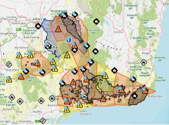
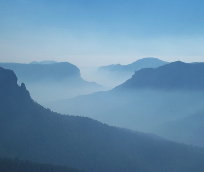
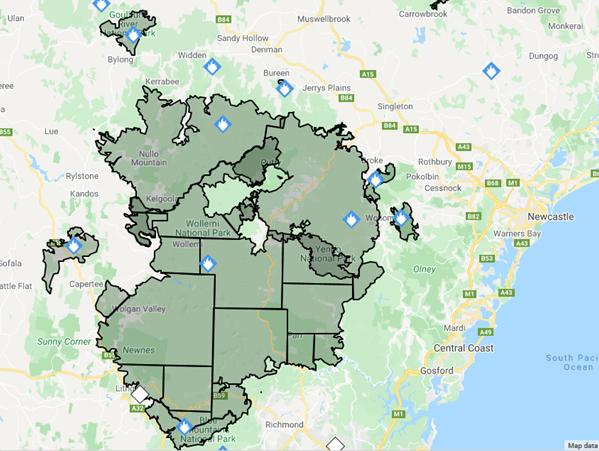 [Image source: ‘Fires Near Me’ Google dynamic overlay mapping, by Rural Fire Service of NSW on its website, ^https://www.rfs.nsw.gov.au/fire-information/fires-near-me, updated 20200128.]
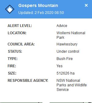 The vast area of the world heritage listed Wollemi National Park is 501,700 hectares. The two bureaucrats charged to protect it were NPWS Upper Mountains Area Manager Richard Kingswood and NPWS Director of Blue Mountains Branch, David Crust. Both jointly delivered Blue Mountains epic fails this Christmas. Both need to be summarily held ultimately responsible and so summarily sacked for gross wold heritage abandonment, incompetence and defacto hazard reduction arson.
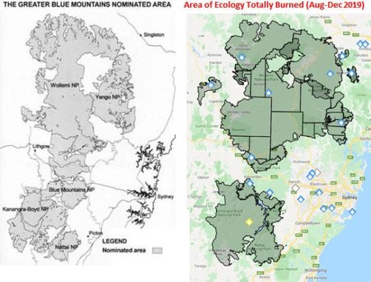 Blue Mountains ecology has allowed to be decimated – 80% of it.
 This is a photo from the desperate and overwhelming 1939 Black Friday Bushfire Disaster across Victoria.
 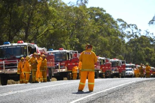 Bushfires typically start in the bush either by lightning or arsonists. Fire trucks are therefore useless; always too little, too late. The arsonists continue to get away with murder, home loss – which often leads to suicides.
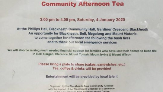
 1300 homes destroyed thus far…but you dare not criticize because those authorities responsible for community safety, hide behind the volunteer veil.
  Hey Wildlife, enact your bushfire plans!
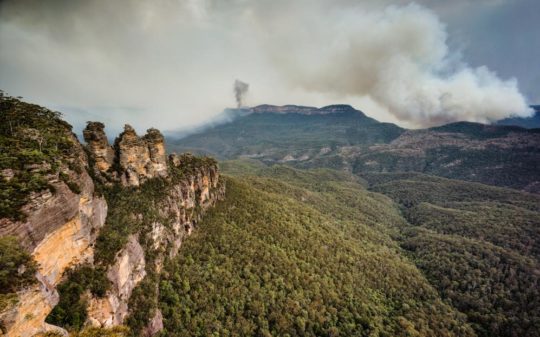 Welcome to the Blue Mountains World Heritage Area. Won’t you enjoy your stay?
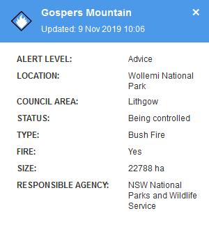
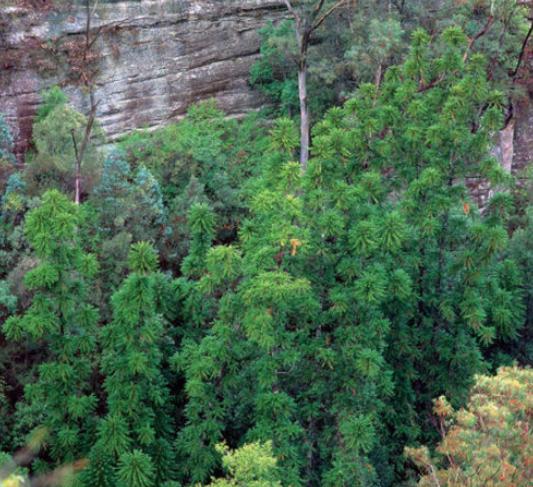
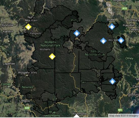
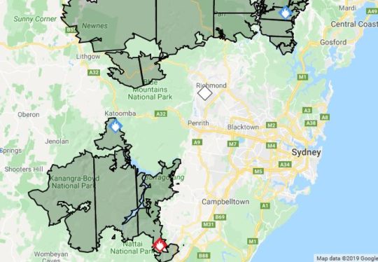

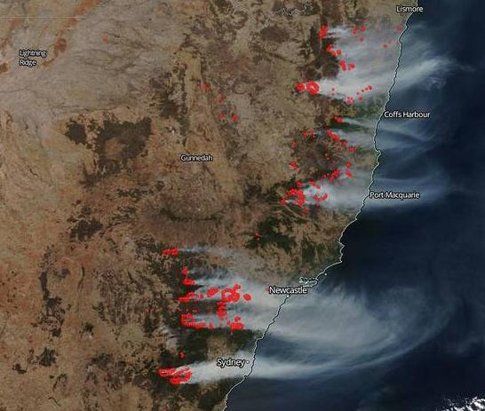
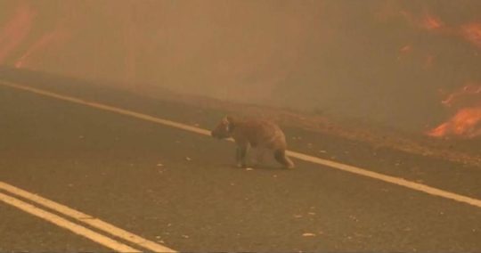
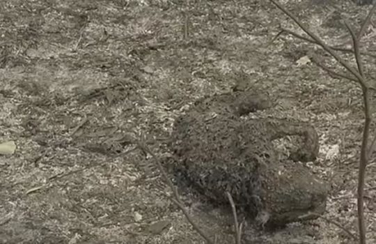
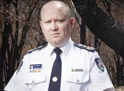
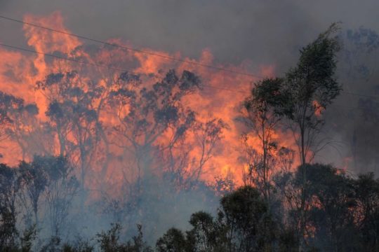


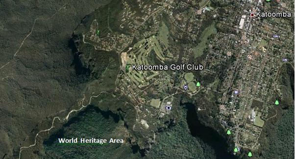
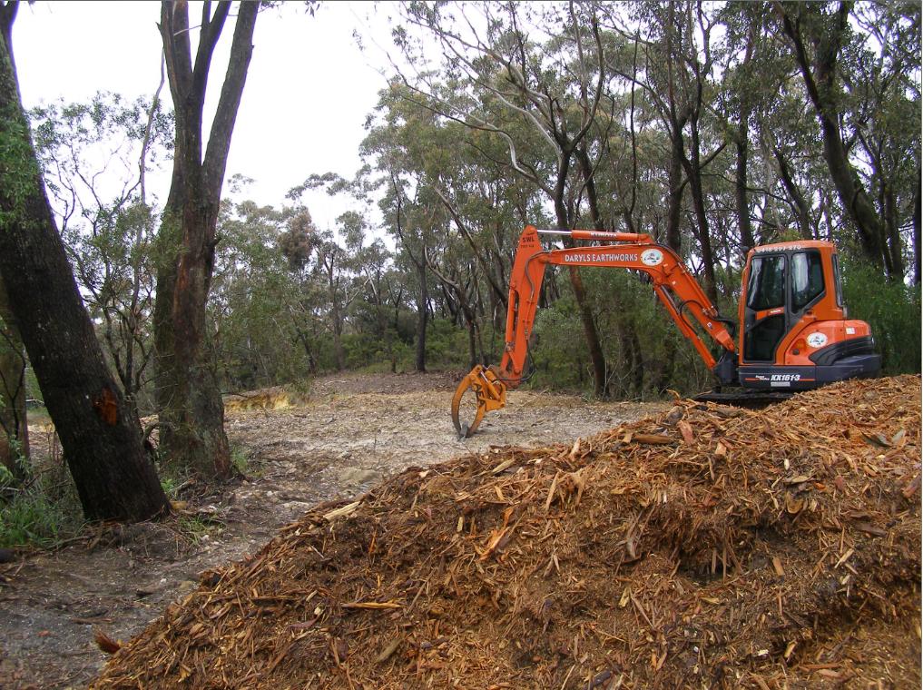
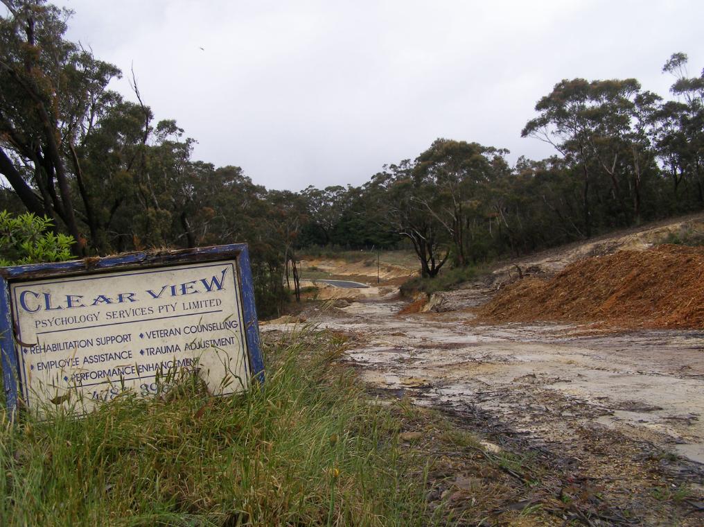
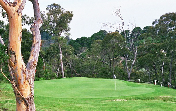

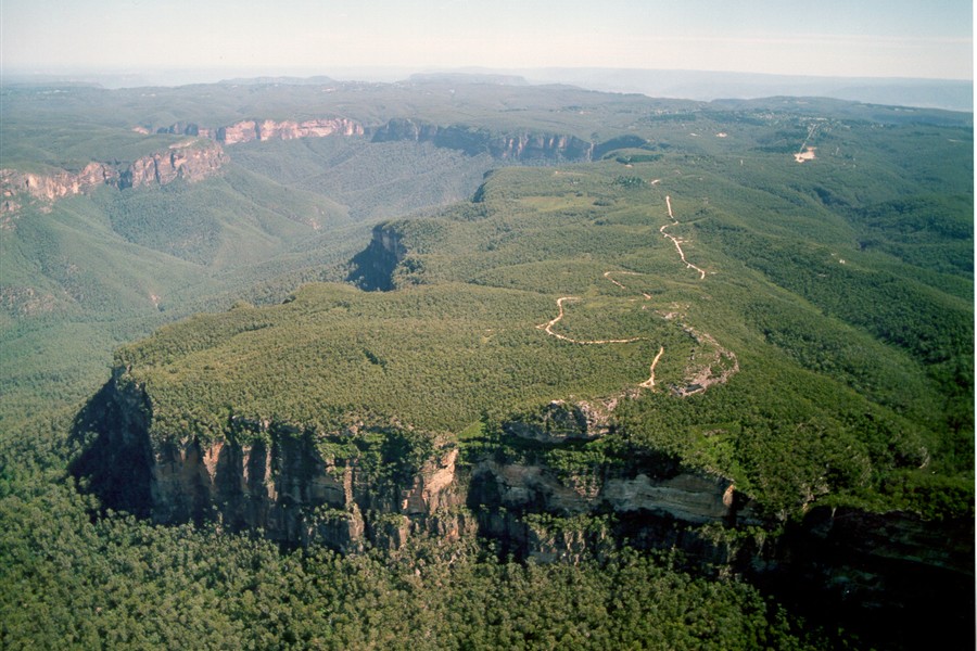


")


")


")
")


")
")


")


")

")

")
")

")
")


