Posts Tagged ‘Cradle of Conservation’

Cradle of Conservation left to incinerate, again

Wednesday, January 22nd, 2020

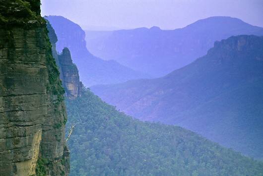
Pre-2006:  The Grose Valley’s 500m+ deep upper Grose Gorge displayed a Blue Mountains profile of sandstone cliffs above talus thickly carpeted by Eucalypt forest supporting rich diversity in plantlife, wildlife, birdlife, creeklife and buglife  – just an eco-happy cradle of conservation. 

(NB: This photo shows Eucy-mist, not Eucy-smoke.  – Ed.)


In 1926, developer Ernest Williamson famously described the Blue Gum Forest in the heart of Grose Valley in the Blue Mountains thus: 

“… a flat, unsurpassed on the mountains for the beauty and grandeur of its trees! Magnificent blue gums, straight and towering skyward in great heights … they appear like the huge pillars of a mountain temple.”

Ernest went on to more infamously propose:

the Valley of the Grose could, in a few years, be transformed from a riot of scrubland to a hive of industry conveniently situated at what has been aptly described ‘the back door of Sydney’”.

According to Blue Mountains historian and author, Andy Macqueen, Williamson’s property development outfit calling itself The Grose Valley Development Syndicate, proposed in the 1920s or the Grose Valley’s forests to be deforested for timber exploitation and that a shale coal mine and coal-fired power station be built there.  It would be an industrialised Lithgow Mark II.   Other threats to the Blue Gum Forest included a proposed railway line and a dam.   So why not a tannery and nuclear waste dump to boot?

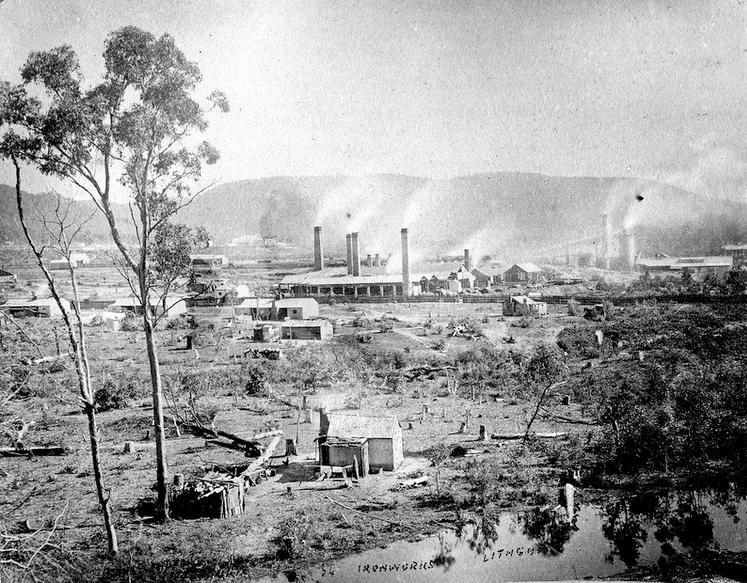
Grose Valley Vision Splendid? – a gross Lithgow industrial vision…note the few remnant token gums retained for ambience, or was it just slack ‘clearing’.


Blue Gum Forest – Australia’s Cradle of Conservation


For generations since the 1920s, conservationists have posited somewhat a more respectful plan for the Grose Valley than by Ernest Williamson and his robber-barons.  The plan being to respect and conserve the ecological values and the anthropocentric aesthetic ‘eye-candy’ tourist benefits of the Grose Valley.

Since 1875, the Blue Gum Forest was the scene of an artists’ camp established by Frederick Eccleston Du Faur of the Academy of Art.  Since then, conservationists have lobbied to protect the Grose Valley from “alienation” – read ruination.  

In 1931, during an Easter hiking trip, a group of bushwalkers from the Mountain Trails Club and the Sydney Bush Walkers club, led by Alan Rigby, camped in the Blue Gum Forest.  

Since 1931 the Blue Gum Forest has been ecologically recognised and presumed protected. 

[Source: Myles Dunphy Collection, Mitchell Library in the State Library of New South Wales, Sydney.]


While the bushwalkers camped, an orchard farmer of Bilpin, Clarence Hungerford, rode in on his horse to confront the bushwalkers ‘squatting’ on his property.  Hungerford had secured a lease of the forest to graze his cattle.   Hungerford told to the hikers that he intended to deforest all the blue gums and to sell the timber in order to finance a walnut orchard.

Blue Gum Forest – flagged for deforestation in 1931 for Hungerford’s walnut orchard ‘vision splendid


The bushwalkers’ Hungerford experience didn’t go down well.  Incensed and horrified, the bushwalkers immediately started a campaign to stop Hungerford’s decimation of the Blue Gum sanctuary.  Their impassioned rallying ultimately raised £130;  quite a substantial sum in the depth of the Great Depression.  They then paid all the funds to Hungerford in exchange for his undertaking to relinquish his pastoral lease of the Blue Gum Forest. 

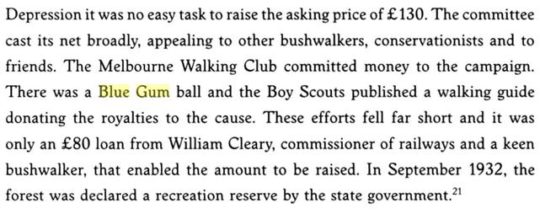
The bushwalkers met with Hungerford at the Blue Gum Forest on 15 November 1931 in pouring rain, and he agreed with their suggestion.   Most of the funding had been donated by James Cleary, then head of the NSW railways, a keen bushwalker and conservationist. One of the key activists in the campaign was Myles Dunphy, who at the time was developing his plans for the Blue Mountains National Park.

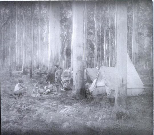
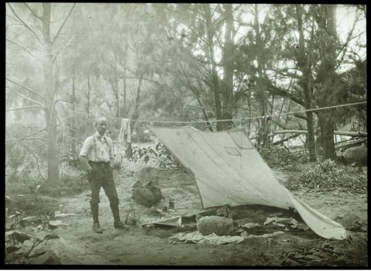
“We hold our land in trust for our successors.” (1934) – Myles Joseph Dunphy (1891-1985), architect, legendary long distance wilderness trekker, map maker, and conservationist before his time.  Dunphy always took his Lee Enfield .303 with him for hunting for food when trekking, like on this occasion – it’s under wraps under the tent fly.  A daily twilight roo kill for protein was the secret behind him managing to trek his incredible distances.   Born on 19 October 1891 in South Melbourne, eldest of seven children… [Read More] 


Hungerford’s horse track became a developer tribute to Hungerford.  The contour-following bush track starts about 300m south of Evans Lookout and descends zig-zagging down the escarpment to the flats of the Grose Valley at Govetts Creek.  In its ignorance, the NPWS or more aptly, the Tourist Parks Service, named this track ‘The Horse Walking Track’ – for visitors to walk their horses? 

The Blue Gum Forest has since been referred to in the conservation movement as the Cradle of Conservation for it was the focus of Australia’s original ecological protection by a small group of “thoughtful, committed citizens” (Margaret Mead quote extract) and which seeded generations later, the international listing of The Greater Blue Mountains World Heritage Area in 2000.  What legends!

Blue Gum Forest survives only as photos, posters and memories.   [Source:  ‘Blue Gum Forest 18-19 October 2014‘, 20141022, © by Dave Noble, ^http://www.david-noble.net/blog/?p=6001.] 

David Noble is the parks ranger who discovered Wollemi Pine (Wollemia nobilis) in 1994.   In September 2012, Noble revisited the Blue Gum Forest leading a hike to celebrate eighty years since the Blue Gum Forest was saved on 2nd September 1932.  

Dave wrote at the time:

“This majestic forest lies at the intersection of the Grose River and Govetts Creek near Blackheath.  Back in 1932, a large portion of the forest (it was then private land) was going to be felled and replaced by walnut trees. Visiting bushwalkers were alarmed, and rallied together and ended up raising money to purchase the block in question and saving it for conservation. Many regard this as the start of the conservation movement in NSW.” 

[Source: ‘Blue Gum Forest – 80th Anniversary 1-2 September 2012‘, 20120913, by Dave Noble, ^http://www.david-noble.net/blog/?p=1846]

But conservationist idealism ignored the arsonist culture.   Government baby boomer arsonists have had a view of native Eucalypt forests like the Blue Gum not as cherished ecology but as a valueless hazard, just like Williamson, generations before.   The New South Wales Government ‘autorities’ have been chafing at the bit for years to hazard reduce Blue Mountains World Heritage “fuel“.  


History of Neglectful Arson


In December 1957, a bushfire that was left to burn in bushland east of the Grose Valley, once the wind picked up, ultimately ripped through the timber clad villages of Leura and Wentworth Falls destroying 170 homes.  

In December 1976, 65,000 hectares of Blue Mountains native bushland was burnt.   A year later, a bushfire burnt out 49 buildings and another 54,000 hectares of Blue Mountains native bushland.

In summer 1982 a bushfire burnt right through the Grose Valley incinerating 35,000 hectares of tall native forest, and wildlife. 

Again in 1994 the Grose Valley was let burnt by bushfire.


Grose Valley Arson in November 2006


Again in November 2006 the RFS backburned into the Grose Valley from Hartley Vale.  Ignited by Rural Fire Service along the north side of Hartley Vale Road on a day of Total Fire Ban, bush arson incinerated native forest ecology up the length of Hartley Valley Road and then was allowed to spot over the Darling Causeway let descend into the Grose Valley.   It was deliberate bush arson sanctioned by the NSW Government under then RFS Commissioner Mal Cronstedt at the time.

The fire was fanned by westerly winds over days, allowed to cross over the Darling Causeway, merge with the Burra Korain wildfire and descend down Perrys Lookdown hiking track in and through the Blue Gum ForestMany Blue Mountains residents will be well familiar with this infamous photo of the Grose Pyrocumulus (flammagenitus) cloud rising from the Grose Valley on Thursday afternoon 23rd November 2006. 

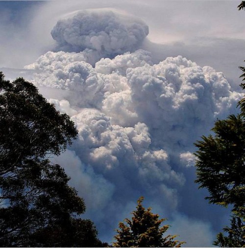
Grose Valley incineration of 2006.  [Source: ‘2006 Grose Fires – the realisation of a tragedy,  20070707, The Habitat Advocate, >https://www.habitatadvocate.com.au/2006-grose-fires-the-realisation-of-a-tragedy/]


At the time there was local community outrage about how the precious Blue Gum Forest was not defended by authorities and allowed to be incinerated.  Blue Mountains resident meetings were staged and a full page article was published in the Blue Mountains Gazette newspaper entitled >’Burning Issues – Fire in the Grose Valley  (a statement funded and supported by concerned residents‘.   It would have cost at least $2000.   Community meetings were held, arranged by former parks ranger Ian Brown.  But then it got political and the campaign was strangely suddenly aborted.

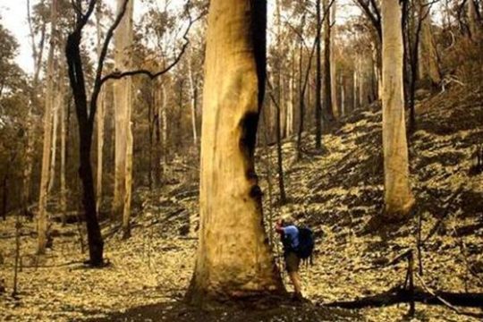
Blue Gum Forest burnt in 2006 by an RFS hazard reduction.  [Source:  Photo by Nick Moir of Blue Mountains Botanist Dr Wyn Jones inspecting the fire damage to the Blue Gums, dated 2006122 in the Sydney Morning Herald, >https://www.habitatadvocate.com.au/2006-grose-valley-fire-a-cover-up/]


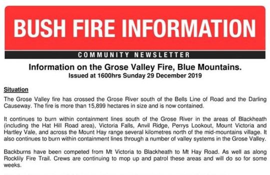
Grose Valley Arson of December 2019


Then Last month in December 2019 the government Baby Boomer arsonists ultimately had their way.   On 16th December, the Gospers Mountain Fire crossed the Bells Line of Road and spotted into the Grose Valley.  By 21st December the Blue Gum Forest was gone.  

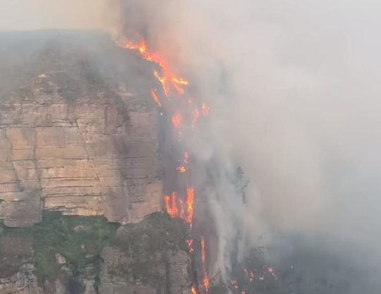
Media warped termed ‘lava waterfall‘ up the Blackheath escarpment in the Grose Valley.

[Source:  Saturday 20121221, ^https://www.facebook.com/BlueMountainsExplore/]


Months prior, a remote rural pastoral property near Gospers Mountain somehow within the Wollemi Wilderness, created an ignition on Saturday 26th October 2019. 

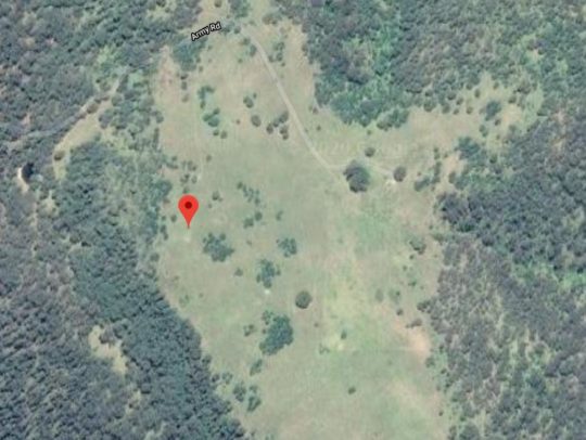
Gospers Mountain showing remote historic rural cattle paddocks deep within the Wollemi Wilderness.  The Australian Government calls it a national park but takes no accountability by delegating custodial protection but no funding to the state government of New South Wales.

Gospers Mountain is 50km NE of the locality of Bell as the crow flies or fire spreads.  Officially declared started by dry lighting in the ‘national park’ on a hot Saturday, this crime of arson and subsequent government firefighting neglect remains secretive.  So NSW Police Bush Arson Squad ‘Strike Force Toronto‘ where are you on this – honest or corrupted by the Premier and RFS?

The RFS Gospers Mountain Fire has been the largest bushfire in New South Wales state history.   The total number of days between Saturday, October 26th, 2019 and Monday, December 16th, 2019 was 51 days; or one month and 20 days.   Over 51 days the fire was allowed to become a ‘megafire’ (likely a new Macquarie Dictionary term for 2020) and ultimately the largest single bushfire in Australia’s history – incineratingmore than 500,000 hectares of bush wilderness…

Of course the Gospers Mountains Fire was left to spread into a mega-fire and to cross over the Bells Line of Road some 50km south-west. 

So what did the RFS do for PR but rebrand the Gospers Mountains Fire southerly spread as a new Grose Valley Fire, and to so to be allowed to incinerate down the escarpment into the Grose Valley and to incinerate the Cradle of Conservation – the Blue Gum Forest.

 As if RFS arsonists care a damn?


Now government paid white collar fire chiefs have had their way.  Forest incineration complete.  Easy-peasy till retirement.


Yes RFS let an ignition with a small plume of smoke rising in remote National Park inaccessible to fire trucks burn neglected for days and weeks, negligent of the consequences.    What hazard predictably eventuates when ignored for weeks?   From the RFS ignition detected at Gospers Mountain on Saturday 26th October 2019 bordering the World Heritage Wollemi National Park …to 16th December 2019 – what response and when was undertaken by the RFS as a supposed fire fighting service?  

Truthful answer:  Defacto hazard reduction because the bushfire was atthe time not immediately threatening human properties.  

Then as normal, the wind picked up, and the wee plume of remote rising smoke morphed into a fire front, then inferno and then into Australia’s worst megafire on record.  

Rural Fire Service (NSW) Commissioner Shane Fitzsimmons (aged 50) is ultimately responsible for the bushfire prevention, planning, resourcing, response for New South Wales outside metropolitan areas services by NSW Fire and Rescue.  In our view the he has failed to protect rural NSW to the standards of urban NSW by failing to oversee a government entrusted fire-fighting authority to promptly detect, respond to and extinguish bushfires in a timely manner. 

His predecessor also repeatedly failed in his bushfire plan and following the 2006 Grose Valley Pyrocumulus of 2006 promptly skedaddled back to Perth to WA’s chagrin and cost (on record). 

​    If only the ‘000’ Fire Brigade extinguisher standard applied outside metropolitan Australia?


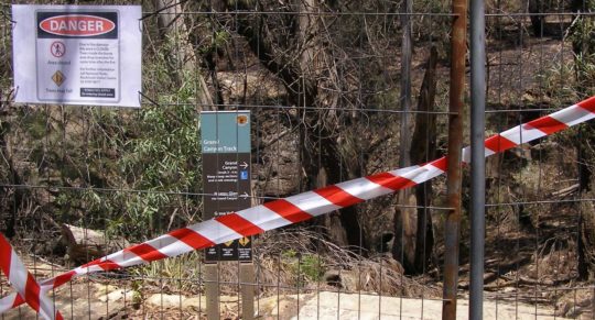
No longer enjoying the benefits of the tourism economy.   The Grand Canyon Track closed since 30 November 2019 and still closed on 21 January 2020 -peak tourist season.

What had started as a small plume of smoke off Army Road on Saturday 26th October on a rural property near Gospers Mountain some sixty kilometres to the north, had been allowed to burn away into the World Heritage of the Wollemi National Park wilderness for weeks.   It was allowed to destroy all the magnificent Wollemi wilderness from end to end. 

By the time the bushfire had crossed to the southern side of the Bells Line of Road 50km south, the RFS changed their pet name of the ‘Gospers Mountain Fire’ to being dubbed the ‘Grose Valley Fir’e.  Why not?  That was the goal – defacto hazard reduction.

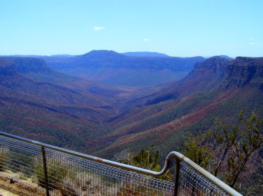
The iconic Blue Gum Forest in the Grose Valley of the Blue Mountains was left to incinerate by the New South Wales Government in December 2019.   They did what Williamson in the 1920s failed to achieve. [Source:  Editor, The Habitat Advocate, photo taken from Valley View Lookout 100m north of Evans Lookout, 20200121]


Once World Heritage values of the Grose Valley have now gone up in smoke.  The icon Blue Gum Forest has been incinerated yet again since the previous RFS successful attempt in November 2006.   No wonder the place is very very quiet.  All the wildlife is dead and the native birds have flow away.

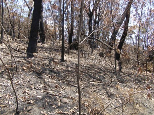
Close up of the Blue Gum Forest from near Evans Lookout (top of photo) showing the canopy of Eucalyptus deanei incinerated; not much left of the forest in the foreground either.  [Source:  Editor, The Habitat Advocate, photo taken from Valley View Lookout 100m north of Evans Lookout, 20200121]

This time they have succeeded in total incineration – their goal of converting hazardous forest ecology into anthropocentric manageable parkland has long been misunderstood by ideologically hopeful environmentalists.  The misnomer National Parks and Wildlife Service (NSW) ethically should now do the right thing and re-brand itself State Parks Administration Service it commercially is.

More than 80% of the Blue Mountains World Heritage Area and more than 50% of the Gondwana world heritage rainforests of northern New South Wales and southern Queensland have been burnt in Australia’s worst bushfire disaster in history.   The scale of the disaster is such that it could affect the diversity of eucalypts for which the Blue Mountains world heritage area is recognised, said John Merson, the executive director of the Blue Mountains World Heritage Institute.

The Habitat Advocate has written to UNESCO’s World Heritage Centre expressing shock, outrage and anger over government mismanagement and contempt for Blue Mountains ecology through abject neglect in bushfire response.  With most of the world heritage incinerated, we have questioning the status of the Blue Mountains World Heritage Area as these values apply to Eucalypt diversity, since 80% has been incinerated.

UNESCO’s World Heritage Centre has expressed concern about the scale and intensity of bushfire damage to the Blue Mountains World Heritage Area and to the Gondwana Rainforests and has asked the Australian government whether it should de-list their world heritage status.   In a statement on its website, UNESCO said members of the media and civil society had asked about the bushfires affecting the areas inscribed on the world heritage list as the “Gondwana rainforests of Australia”. The forests are considered a living link to the vegetation that covered the southern super-continent Gondwana before it broke up about 180m years ago. 

According to UNESCO:

“The World Heritage Centre is currently verifying the information with the Australian authorities, in particular regarding the potential impact of the fires on the outstanding universal value of the property.  The Centre has been closely following-up on this matter and stands ready to provide any technical assistance at the request of Australian authorities.”

Blue Mountains World Heritage is a misnomer and a sick joke.  This RFS blackened moonscape now blankets 80% of the Blue Mountains World Heritage Area.  Incinerated, quite dead, quiet, subsequently oven baked in the scorching sun and now sterilised.  The tamed moonscape is far easier to manage for the Parks Service, like Centennial Park.    [Source:  Editor, The Habitat Advocate, photo taken 20200121 of escarpment track near Evans Lookout.]


Further Reading:


[1]    ‘Grose Wilderness‘, by historian Andy Macqueen, Blue Mountains Nature website, ^https://bmnature.info/conservation-wilderness-grose.shtml


[2]   ‘Wild About Wilderness‘ in ‘The Ways of the Bushwalker’, 2007, a book by Melissa Harper, published by University of New South Wales Press Ltd, pp.258-259.


[3]   ‘Burning Issues – Fire in the Grose Valley‘, 200612, by Ian Brown, Mount Victoria, ^http://www.abc.net.au/cm/lb/6276108/data/grose-fire-gazette-data.pdf


[4]  ‘2006 Grose Fires: the realisation of a tragedy‘, 20120712, by Editor, The Habitat Advocate, >https://www.habitatadvocate.com.au/2006-grose-fires-the-realisation-of-a-tragedy/


[5]   ‘2006 Grose Valley Fire – a cover up?‘, 20101217, by Editor, The Habitat Advocate, >https://www.habitatadvocate.com.au/2006-grose-valley-fire-a-cover-up/


[6]   ‘Bushwalking and the Conservation Movement‘, in printed book ‘Blue Mountains – Pictorial Memories, 1998, by John Low AO, pp. 96-97, published by Kingsclear Books


[7]   2006 Grose Fire – Log of Media Releases‘, by Editor, The Habitat Advocate, >https://www.habitatadvocate.com.au/2006-grose-fire-log-of-media-releases/


[8]    ‘The monster’: a short history of Australia’s biggest forest fire‘ (Gospers Mountain ‘mega fire’), 20191220, by Harriet Alexander and Nick Moir, Sydney Morning Herald newspaper, ^https://www.smh.com.au/national/nsw/the-monster-a-short-history-of-australia-s-biggest-forest-fire-20191218-p53l4y.html


[9]    ‘It’s heart-wrenching’: 80% of Blue Mountains and 50% of Gondwana rainforests burn in bushfires‘, 20200116, by Lisa Cox and Nick Evershed, The Guardian newspaper, ^https://www.theguardian.com/environment/2020/jan/17/its-heart-wrenching-80-of-blue-mountains-and-50-of-gondwana-rainforests-burn-in-bushfires


[10]   David Noble Blog, articles tag=Blue Gum Forest, ^http://www.david-noble.net/blog/?tag=blue-gum-forest


[11]    ‘Lessons from the 1957 Leura Bushfire‘, 20190912, The Australian Bushfire Building Conference website, ^https://bushfireconference.com.au/news/the-1957-leura-bushfire/. Also check:  ^http://www.fire.bmwhi.org.au/


But tell the RFS. 

All they had to do was to put the small plume out when it started, like the proper fire brigade does in metropolitan Australia.


2006 Grose Fires: the realisation of a tragedy

Saturday, July 7th, 2012
The fire tragedy afflicted Australia’s legendary ‘Conservation Cradle’
 A scorched Grose Valley from Evan’s Lookout, looking north up Govett’s Gorge
(Photo by Editor taken 20061209, free in public domain.  Free Large Image)

.

A heritage tragedy unfolds

.

A simple lighting stike ignited remote bushland in rugged terrain within the Blue Mountains National Park, over 5km north of the township of Blackheath on 20061113.

Innocuously, the ignition started off on hilly Burra Korain Ridge,
It was far from settlement but during relatively calm weather and low temperature, so it was not suppressed but ‘monitored’
..then the wind picked up.

.

It and a second ignition west were allowed to continue burning for days until they eventually coalesced with compounded backburning into a firestorm some ten days later down in the Grose Valley.   On 20061122, the prized Grose Valley and its iconic and precious Blue Gum Forest were incinerated under a pyrocumulus cloud of towering wood smoke that could be seen from the Sydney coast a hundred kilometres away.  Some 14,070 hectares of National Park habitat was burnt.  The tragedy did not so much as ‘strike‘ from the lighting itself, but as Blue Mountains residents we saw it ‘unfold‘ over many days and nights under the trusteeship of Bushfire Management.

.

..ten days later

The pyrocumulus cloud of a screaming, dying Grose Valley precious to many, including wildlife
The Grose Valley and its Blue Gum Forest and wildlife burning to death on 20061122
A greenhouse gas estimate was not taken.

.

Community shock, sadness and overwhelming sense of loss

.

How was this allowed to happen?

In the days that followed, many Blue Mountains residents and especially the many conservationists familiar with the Grose Valley and Blue Gum Forest over many years became deeply shocked at learning about the loss of this magnificent sacred preserved forest – its tall 300+ year old rare Blue Gums (Eucalytus deanii).

Without knowledge of personal accounts, one respects that the dramatic scenes of the smoke and fire inflicted personal trauma with many, given so many people’s long and established personal knowledge, affinity, love, awe and respect for..

 ‘The Blue Gum

.

The Habitat Advocate reaches out to these people (doesn’t matter the fact that years have passed) and we choose to express the view of a need to tell truths and to seek some sense of learned maturity from it all.  For the Grose Valley contained many tracks, many walks and many special places if one knew where to look.  Popes Glen and from Govetts Leap down under Bridal Veil following the popular Rodriguez Pass to Junction Rock then Acacia Flat and the Blue Gum Forest in the heart of the Grose.   Many special places includes Beauchamp Falls, Docker Buttress, Pulpit Rock, Lockley Pylon, Anvil Rock lookout, Perrys Lookdown, Hanging Rock, Pierces Pass, Asgard Swamp, and the inaccessible Henson Glen and David Crevasse gorge.

To this editor, the return in 2007 to a previously sacred special, but incinerated Neates Glen was emptying in spirit.  There was heartfelt shock and dismay by many local conservationists familiar with the iconic Blue Gum Forest who became deeply saddened by the tragedy.

Neates Glen, as it was
But since incinerated, not by the wildife, but by deliberately lit ‘backburning’

.

Phone calls and emails were exchanged with many locals wanting to know the extent of the damage and whether ‘the Blue Gum‘ could recover.   The original fire had been fanned westward from Burra Korain Head spotting along the Blackheath Walls escarpment, but then decended and burnt through Perrys Lookdown, Docker Buttress and down and through the Blue Gum.   Deliberately lit backburns had descended and burnt out Pierces Pass (Hungerfords Track) through rainforest into the Grose and everyone had seen the pyrocumulus mushroom cloud towering 6000 feet above the Grose on the 22nd.

There was an immense sense of loss.     The relatively small Blue Gum Forest, perhaps just several hectares, was unique by its ecological location, by its grand age and by its irreplaceability.  The sense of loss was perhaps more pronounced amongst the more mature conservationists, now lesser in number, who knew its original saviours of the 1930s – Alan Rigby, Myles Dunphy and other dedicated bushwalkers who had championed to save it from logging 81 years ago.

The conservation heritage of The Blue Gum Forest dates back to Australia’s earliest conservation campaign from 1931
For this reason ‘The Blue Gum Forest’ has been passionately respected as
Australia’s ‘Cradle of Conservation’

.

The region is home to threatened or rare species of conservation significance living within the rugged gorges and tablelands, like the spotted-tailed quoll, the koala, the yellow-bellied glider, the long-nosed potoroo, the green and golden bell frog and the Blue Mountains water skink.  Many would have perished in the inferno, unable to escape.  The Grose is a very quiet and sterile place now, with only birds.  But to the firefighters, these were not human lives or property.

.

Deafening silence from the ‘Firies’ naturally attracted community enquiry and suspicion

.

The day after the firestorm that enveloped the Grose Valley, the wind subsided and from 20061123 through to the final mopping up date of 20061203, the 2006 Grose Bushfire and its many ember spotfires came under bushfire management control and were ultimately extinguished or else considered to be ‘benign‘.

It is important to note that during the entire bushfire event from 20061113 through to 20061203, only NSW Rural Fire Service ‘Major Fire Updates’ on its website and headline journalism appeared in the local Blue Mountains Gazette newspaper.  Initially, the community, conservationists and ‘firies’ were respectfully passive.    In the immediate aftermath of the fire from 20061204 through to the weekly issue of the  Blue Mountains Gazette on 20061129, the local community, conservationists and ‘firies’ were letter silent in the paper.  It was a combination of shock, preoccupation with the emergency and respectful anticipation of communication from the bushfire authorities.

One can assume here that given the scale of the tragedy, many in the Blue Mountains community were respectfully patient in anticipation of an assured announcement from Bushfire Management or some communication process.  But none eventuated.

.

Injustice

.

The following weekly issue of the Gazette was published on 20061129, but no communication from Bushfire Management.   Only dismissive bureaucratic statements came from Parks and Wildlife’s Regional Director Geoff Luscombe with a tone suggesting minimal damage and business-as-usual.

This was the article:


6th Dec:    ‘Park managers take stock as smoke clears’

[Source: ‘Park managers take stock as smoke clears’, by journalist Jacqui Knox, Blue Mountains Gazette, 20061206, ^http://www.bluemountainsgazette.com.au/news/local/news/general/park-managers-take-stock-as-smoke-clears/487936.aspx?storypage=0]
Ed: This RFS propaganda photo was included in the media article.
Govetts Leap Track (shown here) was deliberately lit by Bushfire Management

.

‘Hundreds of fire-fighters are celebrating a return to normality this week after cooler weather and an intense two-week campaign by volunteers and professionals brought a fire in the Grose Valley under control.

According to the Rural Fire Service this good weather, combined with a thorough mop-up operation and ongoing infra-red monitoring, means flare-ups are unlikely.  However the 15,000 hectare burnt area – including the iconic Blue Gum Forest – is likely to remain closed for the “foreseeable future” due to safety concerns and regeneration.

Geoff Luscombe, regional manager of the National Parks and Wildlife Service (NPWS), said the fact that only part of the Grose Valley burnt meant many animals had been able to seek refuge.

“Many of the Australian plants and animal species have learnt not only to survive fire but to exploit it,” he said.  However he confirmed fears that the fire had burnt Blue Gum Forest – a Mecca for bushwalkers and conservationists in the heart of the Grose Valley.

“Blue gums aren’t a particularly fire-tolerant species,” he said.   “Fire last burnt through Blue Gum in 1994. The effects of this fire we don’t know yet and we may not know for many months to come.”

A botanist has been sent to inspect the area and there could be ongoing monitoring.   Mr Luscombe did not wish to comment on how the fire was handled due to a lengthy absence, but Inspector Jack Tolhurst from the Blue Mountains District Rural Fire Service has warded off any potential criticism.

“I think at the moment we should be looking at the positive,” said Inspector Tolhurst. “The fire is contained . . . It’s been a very long campaign but at the end of the day we haven’t lost any property or lives and half the Grose Valley at least remains intact.”

A fire that broke out near Zig-Zag Railway last week has also been contained.  [Ed.  According to inside reports, Zig Zag Railway Station was accidentally firebombed by an aerial helicopter attempting backburning].

“We’ve had a lot of help from a wide range of people. We’ve had wonderful support from the community . . . it was a wonderful effort from everyone.”

Meanwhile the hard work has only just begun for another group of dedicated volunteers.  Blue Mountains WIRES are expecting to rescue a number of fire-affected native animals in coming months as they wander into residential areas for food and water.

“The arboreal animals – possums and gliders – they come to grief,” said chairperson Greg Keightly. “Birds suffer heat stress and smoke inhalation. They’re going to be flying around bewildered.”

He said residents who see native wildlife in urban areas should keep pets inside, provide water off the ground in a place safe from predators, and avoid the temptation to feed wildlife.

“Things come up for months after fires,” said Mr Keightley.  “Do ring us (4754-2946) if you thing something is injured or doing it tough,” he said.

The national park south of the Great Western Highway, and the lookout at Govetts Leap, are open to visitors.   For information on closures call 4787-8877 or visit www.nationalparks.nsw.gov.au’

.


.

Mismanagement?

.

So the silence from the firies, from Bushfire Management and from the New South Wales Government ultimately responsible and accountable, was deafening.  It was as if the entire Firie fraternity had gone to ground in a code of silence behind closed doors.

So naturally the community response was that something smelt fishy.   This communication intransigence was a public relations blunder by Bushfire Management, to its detriment.

Then filtered out accounts of crazy operational mismanagement during the bushfire and of bush arson by the firies behind the roadblocks beyond the public gaze.

  • Rumours circulated that the initial ignition had been left for burn in the critical first few days of 13th November and 14th November up on Burra Korrain Ridge because it wasn’t right next to a road so that fire trucks could get to it.   The fire had even been abandonned.  Then the wind picked up and it spread. Airborne firefighting was not called in until a Section 44 incident declaration was effected on 15th November.
  • A second fire nearby to the west near Hartley Vale, purported also lit by dry lightning on 14th Nov, had attracted broadscale backburning from the Hartley Vale Road.  But the backburn got out of control, ripped up the valley fanned by winds and crossed over the Darling Causeway on to the Blackheath Escarpment and the Upper Grose to join up with the first blaze.  The onground evidence shows that this was a hazard reduction burn starting from alongside the Hartley Vale Road just east of the village of Hartley Vale.
  • Then came the account of senior bushfire management at the Rural Fire Service headquarters at Homebush ordering a ‘headburning’ a new 10km fire front along the south of the Bells Line of Road into the Grose Valley.  Perhaps the NSW Government had stepped in demanding action.  Perhaps RFS headquarters response was a series of overreactions, albeit too late and to be seen to be now ‘acting’ was only compounding the fire risk to the Grose .  Apparently, the RFS Commissioner had even touted imposing a massive defacto hazard reduction north of the Bells Line of Road right though the vast wilderness of the Wollemi National Park, to somehow head off another fire on 20th November some 80km away north of Wiseman’s Ferry, but that strategy was rejected in a heated operational debate.   [“The Wollemi National Park is part of the World Heritage Area and covers 488,620 hectares.  Important values of the park include the spectacular wild and rugged scenery, its geological heritage values, its diversity of natural environments, the occurrence of many threatened or restricted native plant and animal species including the Wollemi pine and the broad-headed snake, significant plant communities, the presence of a range of important Aboriginal sites and the park’s historic places which are recognised for their regional and national significance.” – Wollemi NP Plan of Management, April 2001]
  • Even the Zig Zag tourist railway station was apparently accidently firebombed by an overzealous airborne firefighter starting backburning en mass
  • Then came the account of Blackheath residents who had their houses subjected to the risk of a deliberately lit backburn during the course of the bushfire.  Despite the out of control wildfire being many miles to the north west of Blackheath, a broadscale backburn (some say is was really a ‘defacto hazard reduction‘)  was lit along the fire trail below the electricity transmission line near Govetts Leap lookout.   But it got out of control briefly and threatened to burn houses in Connaught Road.   Indeed the entire Blackheath Escarpment fire from Hat Hill Road  south through Govetts Leap Lookout and Ebans Head was started deliberately as a ‘strategic’ backburn.
Blackheath Escarpment completely burnt (top) for hectares, looking south from Hat Hill Road
(Photo by editor 20061209, free in public domain, click image to enlarge)

.

The rural property east of Hartley Vale where on 20070207 there was clear evidence of hazard reduction (HR)
commencing only from the south side Hartley Vale Road, opposite.
Eucalypts were burned only at the base, but further up the hill the tree crowns had been burned.
The HR had quickly got out of control and then crossed over the Darling Causeway.
(Photo by editor 20070207, free in public domain, click image to enlarge)

.


Once two weeks had passed since the dramatic firestorm and with only silence emanating from Bushfire Management and the NSW Government, local people had had enough and they wanted answers.

Some 143 local yet disparate conservationists via ‘jungle drums’ met up, discussed the issue, united informally and agreed to go public.  They informally formed the ‘Grose Fire Group‘ and contributed to a fighting fund some $1700 odd and became vocal.  Two weeks after the Grose Valley Firestorm the Grose Fire Group managed a full page open letter in the local Blue Mountains Gazette on 20061206 on page 13.  It was directed to the ultimate authority responsible and accountable for the Grose Fire Tragedy, the NSW Government.  The Premier at the time was Labor’s Morris Iemma MP.  The NSW Member for the NSW Seat of Blue Mountains as well as NSW Minister for Environment at the time was Bob Debus MP.

Those who valued the Blue Gum Forest challenged those responsible for its protection.  The tragedy certainly stirred and polarised the Blue Mountains community.  Conservationists naturally wanted answers, an enquiry, a review of bushfire prevention and management from:

  • NSW National Parks and Wildlife Service under the direction of Regional Director Geoff Luscombe
  • NSW Rural Fire Service under the direction of Commissioner Phil Koperberg
  • Blue Mountains Bushfire Management Committee aligned with Blue Mountains City Council and chaired by Councillor Chris Van Der Kley.

.

Grose Valley Fire – World Heritage takes a hit’

“The Blue Gum Forest, birth-place of the modern conservation movement, was badly damaged by the Grose fire on Wednesday the 22nd of November. If this precious forest was a row of houses, then there would automatically be a major investigation into how the fire was fought. The fact that this major loss of our natural heritage is only now becoming known is testimony to the prevailing attitudes of those controlled the media spin during this recent fire event,” said Keith Muir director of the Colong Foundation for Wilderness.

“Until today the overall perception from the media was that this fire was a good one. No houses or lives lost”, Mr Muir said.

“There where no media updates on the struggle to save Blue Gum. No the reports of success in saving fire sensitive rare plants and rainforests along the escarpment edge. All the media reports spoke of bushland burnt; not on the success of any strategy to minimise the impact on the World Heritage listed national park, while saving lives and property”, he said.

“The Blue Mountains National Park Fire Management Strategy 2004 sets out all the necessary actions to protect the natural environment, as well as life and property. Yet for some reason it appears at this stage that the fire was not fought according to that agreed Strategy, as far as its provisions on natural heritage were concerned”, said Mr Muir.

“Increased fire is a major threat to World Heritage values of the Greater Blue Mountains national parks. Unless we develop and implement better strategies to defend the bush, as well as lives and property, then climate change will make this threat much worse,” Mr Muir said.

“The fire management strategies and techniques undertaken during the fire need to be re-examined to ensure the diversity of the Blue Mountains forests is protected into the future,” he said.

Future fire management requires the feedback that only an inquiry into the Grose Valley Fire can achieve. Such an inquiry should not be taken as a criticism of those involved in fighting fire. It is an opportunity to ensure that everyone stays on fully board with future efforts to minimise fire damages,” Mr Muir said.’

[Source: Colong Foundation for Wilderness, ^http://www.colongwilderness.org.au/media-releases/2006/12/grose-valley-fire-%E2%80%93-world-heritage-takes-hit].The magnificent rich carpeted Gross Valley, as it was
(compare with the lead photo at the start of this article, click image to enlarge)

.

What exacerbated the conflict was not some much that the bushfire had got out of control and had raged through the precious Grose Valley per se, but it was more the defensive, aloof reaction by ‘Firies’ which escalated into a barrage of defensive and vocal acrimony against any form of criticism of the firefighters.

In the face of such palatable denial by the Firies,of any accountability the initial shock and sadness within the local community within days quickly manifested into outrage and anger, and even to blame and accusations.


Most conservationists however felt a right to question and seek specific answers from Bushfire Management about the Grose Fires, for lessons to be learned, for fundamental changes to be made to bushfire management policy, bushfire fighting resourcing and practices, all simply so that such a tragedy should not be repeated.

But the key problem was that the ‘Firies‘ adopted an ‘in denial’ approach to a community suffering loss.   Many Firies denied that they had done anything wrong and rejected any criticism by conservationists.  Some Firies vented their anger in the local media attacking anyone who dared criticise.   Clearly, Bushfiore Management’s debriefing and review of the bushfire in its immediate aftermath was poorly managed.

Underlying the conflict was the Firies urban fire fighting mandate to ‘protect lives and property” – that is human ones, not forests, not wildlife.  Whereas what emerged with many in the Blue Mountains community was the implicit expectation that the World Heritage Area is an important natural asset to be protected, including from devastating bushfire.

The Grose Valley
Greater Blue Mountains World Heritage Area

.

Hence, it was a conflict between differing cultural value systems.  It was about recognition of the value of the natural assets of the Blue Gum Forest and the Grose Valley within the Bue Mountains National Park within the Greater Blue Mountains World Heritage Area.

The iconic Blue Gum Forest
(Acacia Flat, before the pyrocumulus firestorm of 22nd November 2006)

.

The iconic Blue Gum Forest
(The aftermath)

.

20 Sep:  (2 months prior)…‘Fire crews prepare’

[Source: ‘Fire crews prepare’, Blue Mountains Gazette, 20060926]

.

‘With warmer days just around the corner and continuing dry weather the Blue Mountains Region National Parks and Wildlife Service (NPWS) is again undertaking rigorous preparation for the coming fire season.

“Every year around this time the NPWS run a number of fire preparedness days to ensure staff and fire-fighting equipment are fully prepared for the season ahead,” said Minister for Environment Mr Bob Debus.

NSW Labor Minister for Environment
Mr Bob Debus MP

.

“Fire preparedness days require fire-fighting staff to check their personal protective equipment, inspect fire-fighting pumps and vehicles and ensure that communication equipment and procedures are in place and working before the fire season begins.”

Mr Debus said a number of exercises, including four-wheel drive and tanker driving, first aid scenarios, entrapment and burnovers, were also employed to re-familiarise staff with all aspects of fighting fires.

“Burnovers, where fire-fighters are trapped in a vehicle as fire passes over it, is one of the worst case scenarios a fire-fighter can face so pre-season practice is critical to ensure that their response is second nature”, he said.  “Local fire-fighters have also undergone stringent fitness assessments to make sure they are prepared for the physical demands of fire-fighting – like being winched from a helicopter into remote areas with heavy equipment, to work long hours under very hot and dry conditions wearing considerable layers of protective clothing”, Mr Debus explained.

Mr Debus said that fire preparedness and fitness assessment days worked in conjunction with a number of other initiatives as part of a year-long readiness campaign for the approaching summer.

“Over the past 12 months, NPWS officers have conducted more than 150 hazard reduction burns on national park land across NSW.”

.

“Nineteen hazard reduction burns have been conducted in the Blue Mountains region covering nmore than 4500 ha”    ~Bob Debus MP

.

Mr Debus said that while fire-fighting authorities are preparing themselves to be as ready as possible for flare ups and major fires, home-owners in fire prone areas of teh Blue Mountains should also be readying themselves for the approaching season.  “Now is the time to start cleaning gutters, ember proof houses and sheds, prepare fire breaks and clear grass and fuel away from structures”, he said.’

.

20 Nov:     ‘Bushfires rage closer’

[Source: ‘Bushfires rage closer’, by Dylan Welch and Edmund Tadros, Sydney Morning Herald (with Les Kennedy and AAP), 20061120, ^http://www.smh.com.au/articles/2006/11/21/1163871368365.html?from=top5]

.

Wisemans Ferry: 

‘Residents in the historic Hawkesbury River village of St Albans prepared for the worst as raging bushfires neared.  Their predicament came with a  fresh fire outbreak in a  remote corner of Wollemi National Park, 73 kilometres north of Windsor about 2pm.   A Rural Fire Service spokesman said the blaze had destroyed 450 hectares by 3pm. It was being fanned by a string of north-westerly winds and had jumped Putty Road, causing its closure to traffic between Singeleton and Richmond.  Winds of up to 80kmh forecast for the early hours of tomorrow are expected to drive the  fire towards St Albans.   About 45 Rural Fire Service volunteers with 10 tankers have been deployed to protect the small community as residents tried to safeguard their homes from floating embers.  At least two helicopters were in the air to assist the operation.

Wildfire, spot fires and back burning across the Blackheath plateau
(Photo by Rural Fire Service)

.

Blue Mountains:

‘Meanwhile a spokesman for the RFS, Andrew Shade, told (the Sydney Morning Herald) firefighters were waiting to see if changing winds would affect the Blue Mountains fires, which jumped containment lines overnight.  “The fire is across about 7000 hectares; we’ve got 18 aircraft working the fire, including two sky cranes, [and] 400 personnel at the fire on about 60 trucks.”

..Other fires continue to burn across the state, with a number of fires across 7000 hectares in the Hunter Valley burning in remote and inaccessible areas.  Two other fires, near Forbes and Bathurst respectively, are both contained but the RFS has expressed concerns over the weather and its ability to cause a change in the nature of the the two blazes.  Firefighters set up a containment line to protect the outskirts of Blackheath in the Blue Mountains.

Rural Fire Service Commissioner Phil Koperberg said today winds gusting up to 80kmh were predicted for about 3am tomorrow – a time when firefighting planes are unable to fly.   At a news conference in Katoomba, Mr Koperberg described the present threat to Blue Mountain towns as “fairly serious … not grave”.   However, he urged residents to clean fuel away from their homes as a precaution.   This afternoon the most intense efforts were along a containment line at the northern end of Hat Hill Road at Anvil Rock. If that line was breached, the outskirts of Blackheath could be under threat, he said.  Firefighters expected wind changes in the area between 4pm and 6pm today. The Bells Line of Road remains closed and the Blue Mountains National Park will remain closed until further notice.

The Great Western Highway and the Darling Causeway were open but drivers were advised to proceed with caution, with smoke likely to affect the roads.   A total fire ban now applies in all but the north-east corner of the state as temperatures in the high 30s (Celsius), the strong winds and low humidity combine to produce potentially savage conditions…’


.

22 Nov:      ‘Firefighters standing strong’

[Source: Firefighters Standng Strong’, by Shane Desiatnik, Blue Mountains Gazette, Wednesday, 20061122, pages 1 and 3,^http://www.bluemountainsgazette.com.au/news/local/news/general/standing-strong/439486.aspx?storypage=0, Ed: Note this is quoted from the paper edition, which was different to the online edition]

.

‘Thick smoke continues to drift across the Blue Mountains as the largest firefighting and backburning operation in the region since January 2003 enters its second week.

Hundreds of RFS volunteers, NSW Fire Brigades, SES and NPWS personnel, a number of remote firefighting units and 16 waterbombing aircraft are enlisted under a Section 44 declaration with a mission of containing and then attacking bushfires burning in the Grose Valley.  The fires are believed to have been ignited by lightning on Monday, November 13 and at the time of going to press had burnt out 3800 hectares of bushland and private parkland in the valley below Blackheath, Mt Victoria, Bell and Mt Tomah.

No homes were under threat on Tuesday morning, but the RFS almost doubled its resources in the Blue Mountains on Monday night following unfavourable weather conditions.
The NSW FireBrigades also deployed extra fire engines and firefighters ot the Blue Mountains on Tuesday.

The large Blue Mountains bushfire broke its containment lines at Anvil Rock about 11 pm on Monday.  Earlier, a comprehensive backburning operation involving 300 firefighters commenced on Saturday night between Blackheath and Mt Victoria to protect the townships if conditions worsened.  A second phase began along Bells Line of Road between the Darling Causeway and Mt Tomah on Monday morning, continuing to Pierces Pass picnic area to the south.

The backburning activities can cause heavy smoke to linger in residential areas and residents are advised to close windows and doors.  An emergency operations centre is active in Katoomba under the control of Local Emergency Operating Controller and Blue Mountains Police Local Area Commander Patrick Paroz, with the RFS as the lead combat agency.

Blue Mountains RFS community safety officer Eric Berry said remote area firefighting units will continue to attack the fire at the fringe and a fleet of 16 aircraft based in Medlow Bath airfield will operate to contain the fire.

“14 medium to heavy capacity helicopters have been operating 24/7 since last Tuesday  [Ed: This contradicts the official RFS Section 44 Incident Controllers Report – Wednesday 15th not Tuesday 14th]  and we now have three air crane helicopters on the job,” Inspector Eric Berry said.  “This is a massive operation, certainly the biggest in the last three years.  “It involves up to 300 RFS, NSW Fire Brigades, NPWS, police and SES personnel and volunteers at any one time, sourced from all over eastern NSW as well as every Blue Mountains RFS brigade.  “Then there are the support services chipping in like the Salvation Army, who have been supplying breakfast at 5.30 am on a daily basis for the firefighters.”

Inspector Berry said RFS community information meetings last weekend were very successful in seven upper Mountains towns.   “More than 200 residents attended one of the meetings held at Blackheath Golf Club, giving us an opportunity to explain what is going on in plain English.   “More meetings may occur, but in the meantime residents should phone the RFS information line for updates.   “We are getting nearly 6000 hits on our website per day and are updating the site at regular intervals.”

The Gazette visited the Medlow Bath Airfield last Friday, which continues to be a hive of activity.  Six helicopters, including a giant sky crane chopper, took off and landed several times inside an hour, collecting water loads from nearby dams and dropping them into and ahead of the flames.   Kev Adams, an RFS volunteer from Gloucester, described the conditions the pilots had to deal with early last week as wild.

“I came down from Gloucester last Wednesday and we went up in a chopper and the wind was blowing at about 41 knots.  “We hit a pocket of turbulence and I hit my head on the ceiling even though I was strapped in, that’s how wild the wind was.  “Hopefully we’ll be able to head home soon.”

Inspector Eric Berry said good progress has been made, but the weather ahead could test the containment lines.’

.

Ed: Additional reporting in the online version of this article:

‘Severe weather is expected for the Blue Mountains this afternoon between 2.00pm and 5.00pm.  A Total Fire Ban has been declared for a number of areas across the state today, including the Blue Mountains. Temperatures in the Blue Mountains are expected to reach 31 degrees with west-north-west winds gusting up to 45km/h.

Fire behaviour yesterday was subdued due to mild conditions and the main front extinguishing in very low fuel levels. Advantage was taken of these conditions to consolidate containment lines.  The fire has now been burning for fourteen days and burnt nearly 15,000 hectares.

The amount of smoke is likely to increase today. Aircraft and ground crews will be actively patrolling the fire for reactivation of fire edges.  Infrared hot spot technology is being used in an attempt to identify stumps and roots that are still smouldering near the edges. Crews can then locate the hotspots and extinguish them.

The Bells Line of Road between the Darling Causeway and Mount Tomah has been re-opened but may be closed intermittently.  Mount Banks and Pierces Pass trails and tracks are closed to the public.  Residents in the Blue Mountains and Hawkesbury should remain vigilant.’

.

22 Nov:   ‘Bushfire breaks lines again’

[Source:  ‘Bushfire breaks lines again’, 20061122, Sydney Morning Herald, (AAP), ^http://www.smh.com.au/news/national/bushfire-breaks-lines-again/2006/11/22/1163871435049.html]

.

Volunteers back burn along Bells Line of Road as smoke from the fire front can be seen overhead
(Photo by Wade Laube)

.

‘A major bushfire burning out of control in the Blue Mountains again broke containment lines overnight ahead of forecast rugged day for fire fighters.  Two separate blazes have blackened more than 8,000 hectares of the Blue Mountains, west of Sydney, with the larger of the two burning on a massive front about four kilometres north of the township of Blackheath.

Wind gusts of up to 70kph are forecast to push through that area, around Grose Valley, about 4am (AEDT) today.  Blustery conditions expected for most of the day with temperatures in the low 30s (Celsius).

Rural Fire Service (RFS) Commissioner Phil Koperberg has said the towns of Mt Tomah and Mt Wilson would be vulnerable to a wind change.  An RFS spokesman said crews had been working on a 35km containment line through the night but the bigger fire had now broken its eastern containment lines.   He said crews were prepared for the “tricky” conditions expected early today, with wind gusts expected to pick up as the day gets warmer.   Waterbombing aircraft cannot take off until first light but no property is currently under direct threat.

Meanwhile, a new bushfire burning in the Wiseman’s Ferry area is not posing any immediate threat to the village of St Albans, 90km north-west of Sydney.  However, the RFS spokesman said that could also change depending on today’s winds.  A total fire ban has been declared for much of the state today, including the Greater Sydney and Greater Hunter areas, the Illawarra and far south coast, southern and central ranges, the upper and lower central west plains and the eastern Riverina.’

.

23 Nov:     “Massive fire back-burn effort’

[Source:  ‘Massive fire back-burn effort’, Mx (free Sydney commuter newspaper), by Matt Sun, 20061123, page 1]

.

‘Hundreds of firefighters are today hoping a massive 30km containment line will stop the Blue Mountains bushfire in its tracks.  [Ed: Bit late, this is the day after that pyrocumulus firestorm] 

About 200 Rural Fire Service and NSW Fire Brigade firefighters worked overnight on a back-burn between Blackheath and Wentworth Falls.  Firefighters were on standby until temperatures dropped and winds died.  They were sent in to light the back-burn as soon as conditions calmed down.  Crews spent this morning back burning on the Bells Line of Road and hoping to create containment lines near the village of (Mt) Tomah if winds subside.

The RFS said 400 firefighters started work on the blaze this morning.  The weather bureau forecast a maximum temperature of 27C, 45kph gusting winds and 17% humidity this afternoon.

Two fires, both ignited by lightning 10 days ago, joined up this week and have now destroyed 14,500 ha.  An RFS spokeswoman said the fire was burning 2.5 km south of Mt Tomah and 7km north of Wentworth Falls…Crews and 15 aircraft will remain on standby to extinguish any spot fires that pass over teh containment line.  Fire-bombing helicopters Elvis and Shania were likely to be sent to other fires burning across NSW.

The RFS today said Blue Mountains townships were not in immediate danger but should remain alert.  But experts warned the extreme weather conditions would return next week, with the mercury reaching the mid 30s.’

.

29 Nov:     “Firefighters gain upper hand”

[Source: ‘Firefighters gain upper hand’,  by Shane Desiatnik, 20061129, ^http://www.bluemountainsgazette.com.au/news/local/news/general/firefighters-gain-upper-hand/348587.aspx]
RFS propaganda photo for a sympathetic media
These two RFS firies are at the Evan’s Lookout backburn that was deliberatly lit by the RFS
(Photo by Blue Mountains Gazette journalist, Shane Desiatnik, 20061124)

.

The above photo shot taken by the local Blue Mountains Gazette newspaper’s lead journalist, achieved front page on 20061129.  The caption read: “Assessing the aftermath: Medlow Bath RFS crew member Noah Taylor and team leader Michael Anderson near Evans Lookout last Friday.” 

This same photo was re-used by the Blue Mountains Gazette a year later on 20071024 (page 7) to support an article by the Rural Fire Service incident controller in charge of co-ordinating the fire-fighting of the 2006 Grose Fire, Mal Cronstedt, who responded to an article in the paper on this subject by The Habitat Advocate dated 20071010.

.

‘Hundreds of weary but determined firefighters are steadily gaining the upper hand over a Grose Valley bushfire that has burned about 15,000 hectares since November 13.

Daylight waterbombing by a fleet of choppers based at Medlow Bath airfield, increasing access by remote area firefighting units, successful backburns along the northern and southern escarpments and milder than predicted weather conditions since Saturday have limited the spread of the fire.

At the time of going to press, 130 RFS, NSW Fire Brigades and NPWS firefighters and nine helicopters were conducting backburns, mopping up buffer zones and cutting in access trails to the fire’s fringes.  The active front of the fire was within containment lines yesterday morning, allowing the Bells Line of Road and Mt Tomah Botanical Gardens to re-open.

A small fire that started at Mitchells Lookout in Mt Victoria on November 23 is extinguished and investigations are continuing into its cause.

Blue Mountains RFS is warning residents to remain vigilant by continuing to prepare their homes for fire if conditions worsen and to immediately report any suspicious activity to CrimeStoppers by calling 1800-333-000.

The milder conditions are a welcome relief from the heat and 100 km/h wind gusts that put residents of Hazelbrook, Linden, Faulconbridge and Winmalee on high alert last Wednesday afternoon.

An explosion within the fire, which witnesses described as causing a mushroom-like cloud to develop, ignited spotfires four kilometres north of Lake Woodford and five kilometres north of Hazelbrook.   Many residents headed home early from work to clear gutters and roofs and two Winmalee schools opted to close for 24 hours as a precaution.  Eighteen water-bombing aircraft attacked the spotfires, extinguishing one within hours and the second by Thursday evening.

For daily fire updates and advice, go to www.bluemountains.rfs.nsw.gov.au, phone a dedicated 24-hour hotline manned by local volunteers on 1800-264-525 or visit your local RFS station, staffed by volunteer station officers.

“These people are the unsung heroes of the RFS,” Blue Mountains RFS public liaison and education officer Paul McGrath said.

.

Overwhelming grief shunned by government hush, galvanised an immense sense of environmental injustice :


It was time to challenge (with due civility) the unaccountable bastards in authority…the NSW Government:

An extract of a full page letter in the Blue Mountains Gazette 20061206 on page 13
It was commissioned by 143 concerned Blue Mountains residents
It was addressed not to the ‘firies’, but to the NSW Government.

.

Pulpit Rock on the left of the Grose Valley, before the firestorm
It is easy to see why the Blue Mountains, with their Eucalytus tree oil suspended in the atmosphere, get their famous name.
(Photo by Chris Ellis)

.

Grose Leadership

Saturday, December 3rd, 2011
The following article was first published in the Blue Mountains Gazette newspaper 20060122:
.Blue Gum Forest, Grose Valley, Blue Mountains
[Source: AK Bushwalks, ^http://mywebdots.com/bushwalks/?page_id=26]

.

A tall moist open forest dominated by Blue Gum (Eucalyptus deanii) characterises the famous ‘Blue Gum Forest’ at the junction of the Grose River and Govetts Creek in the Grose Wilderness.

But there would be no Blue Gum Forest if it were not for the efforts of a dedicated band of very fit bushwalkers seventy odd years ago.  In 1931, under the leadership of Myles Dunphy, the ‘save Blue Gum Forest’ campaign was ignited by the threat by a leaseholder on the Grose River/Govetts Creek junction wanting to clear the icon stand of tall blue gums for cattle grazing.  Consisting of members of the Wildlife Preservation Society, the Sydney Bush Walkers and the Mountain Trails Club, they formed the Blue Gum Forest Committee.  Hard campaigning secured purchase of the forest for £130, which they handed back to the Crown and on 2nd September 1932 was proclaimed a recreation reserve.  They unknowingly in their bold defence of the Blue Gum Forest, established what has become known as Australia’s ‘cradle of conservation‘.

It took another 27 years of wilderness campaigning for The Blue Mountains National Park to be proclaimed in 1959 and the Blue Gum Forest incorporated two years later.

Despite deserved World Heritage listing in 2000, the Grose has again come under threat. This time last year, tonnes of caramel sediment from highway upgrade stockpiling at Leura started choking Govett’s Creek.  Seems the RTA simply underestimated Mountains weather.

To the credit of Leura residents, grassroots leadership has again emerged to defend the Grose and to hold the RTA accountable.  A year hence, council has responded with a working party to develop remedial actions, although ‘in-creek’ action remains wanting. Abundant photographic evidence and a moral obligation warrant the RTA fund ecological remediation.

Caramel-coloured construction sediment from the RTA’s Trucking Expressway
Leura, Blue Mountains 2006
(click photo to enlarge, the click again to enlarge again)

.

But where was the custodial manager of the Grose while the damage was being reported?  The Department of Environment and Conservation (National Parks) and the environmental enforcer (the EPA) have been conspicuously muted to environmental breaches caused by their sister government agency.

RTA sediment from the upstream Trucking Expressway development
polluting Govetts Creek inside the Blue Mountains World Heritage Area.
Photo of Editor in Govetts Creek, Leura, Blue Mountains 2006

.

error: Content is copyright protected !!