Posts Tagged ‘NPWS’
Monday, December 17th, 2012
 McIntyres Hut Bushfire in Brindabella National Park, New South Wales, 8th January 2003
It was manageable then, but negligently left to burn for days by the Rural Fire Service McIntyres Hut Bushfire in Brindabella National Park, New South Wales, 8th January 2003
It was manageable then, but negligently left to burn for days by the Rural Fire Service
.
On 8th January 2003, reported lightning strikes had ignited remote fires in the Brindabella National Park inside New South Wales and in Namadgi National Park in the Australian Capital Territory (ACT).
Ten days later, the McIntyres Hut Bushfire along with the Bendora Bushfire, the Stockyard Spur Bushfire and the Mount Gingera Bushfire, coalesced and burnt out of control into the south-western suburbs of Canberra.
It tragically became The 2003 Canberra Firestorm.
- Four people perished
- 435 people were injured, many suffering horrific burns
- 487 homes and 23 commercial and government premises were destroyed
- 215 homes, commercial premises, government premises and outbuildings were damaged
- Mount Stromlo observatory (an institution of international renown) was destroyed
- An inestimatable number of animals (livestock and wildlife) were killed
- Almost 70% of the ACT, some 157,170 hectares were burnt
.
 Canberra Firestorm looms
[Source: SOSNews.org, ^http://www.sosnews.org/newsfront/?p=236] Canberra Firestorm looms
[Source: SOSNews.org, ^http://www.sosnews.org/newsfront/?p=236]
.
The ACT Coroner Maria Doogan conducted an inquiry into the cause, origin and circumstances of the bushfires and inquests into the four deaths associated with those fires. On December 2006, her findings: ‘The Canberra Firestorm‘ concluded that “failure to aggressively attack the fires in the first few days after they ignited” was a key factor that led to the firestorm.
Coroner Doogan was also scathing of the ACT’s Emergency Services Bureau (ESB) for:
- Failing to attack the fires that had been burning for 10 days before they reached the capital.
- Failing to warn residents of the danger early enough, saying this exacerbated the property losses and caused panic and confusion on the day of the firestorm.
.
But responsibility for fire suppression inside the Brindabella National Park also lay with the NSW National Parks and Wildlife Service.
Today ACT Supreme Court Chief Justice Terence Higgins has found that the New South Wales Government (Rural Fire Service) was negligent in the way it tackled the January 2003 blaze.
One of the plaintiffs suing the NSW Government, Brindabella landowner Wayne West said today “We have won the case on negligence, the judge has made a decision the fire should have been fought and could have been fought in a different manner, and we win the case at common law.’’
Mr West, along with plaintiffs represented by insurance giant QBE Insurance, have been suing the NSW Government for gross negligence.
But the NSW Rural Fires Act 1997 confers immunity from liability if the Rural Fire Service acted “in good faith”. This means that even though the Rural Fire Service is guilty of gross negligence, it and its members are immune from prosecution for negligence, becase they can hide behind the NSW Rural Fires Act.
So Chief Justice Higgins has ruled in favour of the NSW Government.
“The result I have reached is that the plaintiffs’ claim must, as a matter of law, be denied,” Chief Justice Terence Higgins said today in an 86-page judgment.
“However, but for the express limitations on the liability which otherwise would attach at common law, those plaintiffs who suffered loss or damage would have been entitled to compensation for their losses. Effectively, they are deprived by statute of what would, under the general law, be regarded as just compensation.”
“The legislature has, however, spoken so as to exempt NSW from such liability, and the courts must apply the law as parliament has decreed it.”
The judge agreed with the plaintiffs that the NSW Rural Fire Service embraced an “inadequate and defective strategy. “The question is, however, whether the adoption of that strategy, albeit negligent, was ‘so unreasonable that no authority could properly consider the act of omission to be a reasonable exercise of its functions’.”
The judge identified failures in strategic planning, but made no criticism of the front-line firefighters “at any level”.
Mr West said while the ultimate decision was “devastating” the case was never about the money.
“That fire was allowed to burn, there could have been action taken to prevent the fire escaping or being enticed to escape. The fires shouldn’t have burnt the houses and [caused] the injuries and the four lives in Canberra, that’s what we were here for from day one.’’
When asked what lessons should be taken from the firefighting response Mr West replied:
.
“Get in the fire immediately and look at the fire – don’t look at it 50 kilometres away.”
 Bushfire Progress – click on image
(The top red patch is the McInture Bushfire inside NSW) Bushfire Progress – click on image
(The top red patch is the McInture Bushfire inside NSW)
.
Alan Conolly, representing the QBE clients, said they would read the judgment and consider their options.
“There’s always, in a case as big as this, there’ll be issues we have to look at, and at the moment we first have to read the judgment and advise our clients,” he said.
West has immediately flagged a decision to challenge this decision and to take that fight to the ACT Court of Appeal.
“We have only fallen over in the courtroom today on an Act the [NSW] government put in place…the state doesn’t have a duty of care to an individual, and that’s where we fell over today”, West said.
.
[Source: ‘West to appeal after losing 10-year court battle’, 20121217, by Louis Andrews (journalist), Canberra Times, ^http://www.canberratimes.com.au/act-news/west-to-appeal-after-losing-10year-court-battle-20121217-2biea.html]
.
") ACT Bushfire Memorial (Duffy) ACT Bushfire Memorial (Duffy)
.
Editor’s Comment:
.
The general community has right to expect that government, as the public authority, must be at all times properly diligent in performing its duty it owes to its dependent community. This is perhaps no more so than its implied fiduciary duty to protect the community from harm. Outside the military, the emergency services duty of government – be it police, ambulance, fire, disaster response – stands at the forefront of this fiduciary duty because this is where the risk and consequence of harm to the community is greatest. This is the basis of community trust in government and the rule of law, otherwise as a society we resort to ‘every man for himself’ chaos.
Under Division 1, Section 63 of the Rural Fire Act 1997, there is a prescribed duty of the public authority (the Rural Fire Service) to prevent bush fires, and this necessarily includes taking:
“any other practicable steps to prevent the occurrence of bush fires on, and to minimise the danger of the spread of a bush fire on or from any land vested in or under its control or management.“
Allowing the known McIntyre Fire to burn for multiple days without diligent suppression response has been found by the ACT Coroner and the ACT Supreme Court to have been negligent. Since this fire was situated on Crown Land in New South Wales, the New South Wales Rural Fire Service owed a fidicuary duty of care to the community to ensure resource capability, to diligently suppress and properly extinguish the fire, which it fundamentally failed to do.
The Rural Fire Service owed a higher duty of care to the community to properly extinguish the fire, than with other concerns such as cost mitigation by avoiding the cost of aerial suppression. It is a breach of that duty of care when a public authority under-resources and under-performs emergency management response. It is shameful that governments continue to hide behind legislation and volunteers when the risk and consequences of bushfire and wind changes are known. The community has a right to entrust government capability and to trust legislation to serve the bests interests of the community, not the convenience of government bureaucracy.
The McIntyre Fire started off some distance from human settlement and would have been operationally treated as a defacto hazard reduction. It is past time that the high duty of fire fighting to protect life and property extends to protecting the valuable ecological integrity of the community’s national parks. The interface between life, property and national parks has become intertwined and all it takes is a change of wind for bushfire risk to morph from being ‘contained’ to being ‘catastrophic’.
.
Further Reading:
.
[1] ACT Coroner Report into the Canberra Firestorm 2003, published December 2006, >Read Report, (PDF, 400kb) ^http://www.courts.act.gov.au/resources/attachments/The_Canberra_Firestorm_%28VOL_I%29.pdf
.
[2] ACT Supreme Court Decision: ‘WAYNE WEST & ANOR v THE STATE OF NEW SOUTH WALES [2012] ACTSC 184 (17 December 2012), >Read Decision, (PDF, 2.5MB), ^http://www.courts.act.gov.au/supreme/
.
[3] Related article on this website: 2006 Grose Valley Fires – any lessons learnt?
.
Tags: 2003 Canberra Firestorm, ACT's Emergency Services Bureau, Brindabella National Park, McIntyres Hut Bushfire, negligence, NPWS, NSW National Parks and Wildlife Service, NSW Rural Fire Service, QBE Insurance, RFS, Wayne West
Posted in Threats from Bushfire | 1 Comment »
Add this post to Del.icio.us - Digg
Saturday, August 18th, 2012
 Six Foot Track being bulldozed into a two-laned RFS Fire Trail
(Photo by Daniel Kelton, 20120802) Six Foot Track being bulldozed into a two-laned RFS Fire Trail
(Photo by Daniel Kelton, 20120802)
.
News is filtering out that a large section of the iconic Six Foot Track has been bulldozed and vast swathes of forest destroyed.
The Six Foot Track starts from the Blue Mountains west of Sydney near the famous Explorers’ Marked Tree on the Great Western Highway near Katoomba and traces through wild gorges, forests and over ridges to the famous Jenolan Caves, some 42km to the south-west.
‘The Track descends via Nellies Glen to the Coxs River and then climbs Blacks Range before descending again to the Jenolan River by way of Binomea Ridge. In traversing The Track walkers cross a number of distinct cultural and physical landscapes.
 . .
 [Source: ^http://www.adventure.com.au/SixFootTrack.asp] [Source: ^http://www.adventure.com.au/SixFootTrack.asp]
.
William Cooper was instructed in 1884 to undertake a survey of a bridle track between Katoomba and Jenolan Caves. Cooper also supervised the construction of a track which had a width of six feet following approval by the New South Wales Parliament.’ [Source: ‘Six Foot Track Conservation and Management Plan’, 1997, Foreword, prepared by Integrated Site Design Pty Ltd in association with Jim Smith for the Six Foot Track Heritage Trust].
 The 19th Century Heritage of the Six Foot Track
(An old photo at the information shelter at the start of The Track) The 19th Century Heritage of the Six Foot Track
(An old photo at the information shelter at the start of The Track)
.
Aug 2012: Track Bulldozed
.
Two weeks ago, on Thursday 2nd August 2012, an Outdoor Recreation Lecturer leading a group of students along the Six Foot Track happened across a crew of construction workers driving bulldozers and in the process of destroying the Six Foot Track. The section of the track affected is situated between Allum Creek and the Black Range Campsite.
When challenged, the construction workers said that the work had been approved by Oberon Council and Kanangra Boyd National Parks Office. They were calling it “road maintenance“.
So much for the Six Foot Track and its 19th Century heritage. It is now a six metre wide road so that fire trucks can hoon along ringing their fire bells in the middle of the forest. In some places the Track has been bulldozed it to 30 metres wide!
 Six Foot Track bulldozed beyond recognition
(Photo by Daniel Kelton, 20120802) Six Foot Track bulldozed beyond recognition
(Photo by Daniel Kelton, 20120802)
.
Daniel Kelton, an Outdoor Recreation Lecturer at TAFE and a Bush Walking Guide for a regional commercial company leads regular walks along the Six Foot Track more than twenty times a year.
“I saw numerous earth moving machines blocking the iconic track, doubling the width of the original fire trail in places, I saw many old growth trees bulldozed and pushed into the bush in piles, I saw water drains driven excessively into the vegetation on each side of the track. I witnessed stunned native birds walking amongst the newly felled trees. The impact is over a 15km section of the 6ft Track and has impacted up to 30 metres each side of the original fire trail”, Mr Kelton said.
 . .
Initial investigation has revealed that the earth works were given the go ahead by Oberon Council Engineering Service’s works manager, Ian Tucker, and the Oberon Area Manager with the New South Wales National Parks and Wildlife Service (NPWS), Kim De Govrik, apparently without any environmental, hydrological, or cultural heritage assessments or supervision.
After initial complaints being made to National Parks and Wildlife Service office and Oberon Shire Council from Friday 27th July, road works where substantially decreased, yet Aboriginal sites were damaged after these concerns where raised.
") NPWS Oberon Area Manager, Kim De Govrik, in mock bandage leading a protest rally last June NPWS Oberon Area Manager, Kim De Govrik, in mock bandage leading a protest rally last June
[Source: Western Advocate newspaper, Photo by Chris Seabrook,
^http://www.westernadvocate.com.au/story/96608/riled-rangers-target-national-park-hunts/]
.
Wanton Destruction of Habitat and Cultural Sites
.
Initial onsite investigation has confirmed the following damage caused along the Six Foot Track:
.
- Aboriginal Sites have been destroyed at Mini Mini Saddle, Kyangatha Station and Alum Creek along the Track
- Road works have been bulldozed to within less than a metre of watercourses along Little River (large piles of dirt waiting to be washed into the river in the next rain)
- Counted 213 mature native trees pushed over with a 300 mm or more Diameter at Breast Height (DBH)
- At least 23 hollow forming (habitat) trees pushed over
- Heritage listed fence post and gate from the old Kyangatha Station knocked down and has disappeared.
- The Six Foot Track has been widened, up to double its original width, “For fire trucks to pass” as explained by NPWS Oberon Office
- Water mitre drains have been pushed into the bush up to 50 metres in length
- Considerable destruction of native vegetation and top soil removal through wetland areas, which may fall under the ecosystem classification of a Montane Peatlands (Temperate Highland Swamps on Sandstone?)
- Water drains have been created in inappropriate or unnecessary locations
- Piles of soil have been graded into Spring Gully at Grid Reference 2234450E 62603500N, with no silt trap to prevent siltation of the watercourse
- Vast areas of exposed soil left will inevitably attract weeds
- Large amounts of non-road or safety related impact on vegetation stretching up 50 square in some areas.
- There appears to have been no consultation with land owners, or the Aboriginal Land Council, or Gundungurra people of the region
- The damage will cause serious adverse impact on tourism appeal of The Six Foot Track
- Since the Six Foot Track is now no longer a walking track, vehicles will use it and present a hazard to bush walkers walking along the new road.
 . .
The Aboriginal site destruction and massive Native Flora impact was which committed by a contract road works gang, who where engaged to undertake the works without any impact statements, by Ian Tucker of Oberon Shire Council. The destruction has occurred between Grid Reference 2236590E 6262500N at old Kayangatha Station Ruins and Grid Reference 2269000E 6260600N at the edge of the Pine Forest.
Aboriginal Sites that have been destroyed by machinery are at the following grid references:
.
- Kyangatha Station: 2236590E 6262500N on the right edge of the road 50m North of the cattle grid. Two chert flakes, and one quartz flake
- Mini Mini Saddle: 2235850E 6261700N on the flat cleared ground opposite the un-used cattle grid. Six chert flakes, a direct impact break in one of the flakes from a heavy machine rolling over it
- Alum Creek: 2234900E 6260500N on the Little River side of the road opposite Tree of Heaven cluster. One white chert flake.
.
All sites are comprised of small chert and quartz flake material of varying colours and sizes. The size of the materials vary from 10mm to 50mm. I was led to believe that the site in which heavy rolling machines have rolled over, and broken some of the chert flake pieces, at Mini Mini Saddle was a pre-recorded camp site. This directly breaches Section 90 of the National Parks and Wildlife Act 1974, whether the sites where identified prior to the works or not.
In an undated Archaeological assessment of the Six Foot Track by Hooper and Marloo, which ran numerous predicted modelling of Archaeological significant areas it was interesting to note that the Black Range was mentioned as a possible route to the West from the Megalong and Kanimbla Valleys. The significance of the ridge as a travel path remained un-assessed, although it was noted as a highly likely area for Aboriginal sites. It is also interesting to note that the only two site areas in the West of the Six foot track that where impacted by the recent works, were listed in the article.
.
Why?
.
The unsupervised construction workers called it “routine maintenance”. Crap! Clearly, this is illegal land use development. It is wanton irreverible vandalism of important New South Wales natural and cultural heritage.
 Oberon Man? Oberon Man?
.
It appears the Oberon Council was in a hurry to spend “a big payout from flood relief money” according to one of the construction workers, and that they fast tracked the earth works. They told National Parks and the Six Foot Track Heritage Trust that the works where only minor and would fall under the banner of “routine maintenance“.
But how can flood relief money be connected to converting The Six Foot Track into a two-laned fire trail? Has the funding been misappropriated by Oberon Council?
 In the past two weeks, many of the so called ‘improvement areas’ have subsequently
returned to their original boggy state even after little to no rain.
This begs the question: Why the works where carried out in the first place? In the past two weeks, many of the so called ‘improvement areas’ have subsequently
returned to their original boggy state even after little to no rain.
This begs the question: Why the works where carried out in the first place?
.
National Parks seem to have agreed with the works, so that they can now drive two fire trucks along it – hooning along a nice wide speedway two abreast.
 You reckon? You reckon?
.
“I feel very hurt, and disheartened by the damage to the Track, and I have many unanswered questions”, says Mr Kelton:
- ‘How can Oberon Council claim that the large amount of impact was only routine maintenance?’
- ‘Why where local Aboriginal Land Council Members not consulted about the impact on potential sites?’
- ‘Why was there no member from National Parks or Aboriginal Lands Council on the ground during the works to assess (supervise) damage?’
- ‘Why where local businesses and tour operators not consulted or informed?’
- ‘Why does National Parks need to drive two fire trucks along the track, as there are no residential properties along the Black Range Road, and fire trucks could not pass each other on any of the long hill sections anyway?’
- ‘Would a more thoughtful, ongoing fire control regimes negate the necessity for emergency fire truck access?’
- ‘Was the impact to local tourism even considered?’
- ‘What will be the safety and aesthetic impact of the widened road for bushwalkers, who share the track?’
.
 Aboriginal rock implements found along the bulldozed section of the Six Foot Track
Aboriginal cultural sites have been reportedly destroyed
at Mini Mini Saddle, Kyangatha Station and Alum Creek.
. Aboriginal rock implements found along the bulldozed section of the Six Foot Track
Aboriginal cultural sites have been reportedly destroyed
at Mini Mini Saddle, Kyangatha Station and Alum Creek.
.
 Oberon Man’s Day Off? Oberon Man’s Day Off?
.
History of Government Vandalism to Six Foot Track
.
Destruction to The Six Foot Track is not new. Back in June 2005, the Blue Mountains Bushfire Co-ordination Committee, under the chairmanship of Blue Mountains Councillor Chris Van Der Kley, subcontracted a similar bulldozing of the Nellies Glen section of the Six Foot Track. Again the earth works were unsupervised. Again the earth works caused considerable ecological and riparian damage and again they involved reckless bulldozing through documented Aboriginal sites and cultural heritage – as in the case now, numerous ancient stone implements were discovered disturbed by the trail making works.
 In August 2005, recent bulldozing of the Six Foot Track was inspected
by local Indigenous people and members of the Blue Mountains Conservation Society In August 2005, recent bulldozing of the Six Foot Track was inspected
by local Indigenous people and members of the Blue Mountains Conservation Society
(Photo by Liz Mitchell, 20050814)
.
Subsequent remediation of the works involved a number of stakeholder meetings and the responsibility for environmental remediation was passed from the BM Bushfire Co-ordination Committee to the Blue Mountains Council to fix. The earth works had resulted in significant disturbance of the road verge in several sections along the road. Ultimately the remediation was carried out by a soil remediation consultant through the New South Wales Department of Lands Soil Conservation Service costing $27,000.
The Soil Conservation Service inspected the damage and created a rehabilitation plan and specification for a section of Crown Road and Crown Reserve (Nellies Glen Road and along the Six Foot Track) where fire trail maintenance works were implemented by the Blue Mountains Rural Fire Service.
The majority of the mitre drains installed typically exceeded the recommended amount of fall. Many of the mitre drains have been extended into drainage lines and were already actively eroding. There were several sections of track where mitre drains had been installed and there was insufficient drainage / fall causing water to build up and likely to erode the table drains and / or mitre drains down slope. Several small culverts had been graded over limiting their capacity. There were several sections of track where water flow would likely increase due to the slope and lack of drainage measures. Several creek crossings had been graded over, potentially exposing the creek bed to scour. There was also noted significant clearing and disturbance along the length of the roadside/track.
All sound familiar? Read More: >’Report and Specification for Restoration Works on Nellies Glen Road and the Six Foot Track (Aug 2005) (PDF, 730kb).
The Department of Lands Soil Conservation Service is the New South Wales Government agency to which the custodial Six Foot Track Heritage Trust reports.

Back in 2005, a local Blue Mountains resident, Liz Mitchell, reported her similar shock discovery of recent bulldozing along the Nellies Glen section of The Six Foot Track to this Editor. At the time, this Editor was acting in the capacity as Honorary Director of Colong Foundation for Wilderness. Subsequent investigations were initiated including a walk down The Track to inspect the damage first hand. This Editor wrote the following two articles in the Local Blue Mountains Gazette in the weeks following:
.
Letter #1: ‘RFS Bulldozes Six Foot Track’
.
This is what a bulldozer can do midweek when nobody’s watching. (Ed: See photo above)
The Six Foot (Bridle) Track is a State icon, first negotiated on horseback in 1887 as a shortcut from Katoomba to Jenolan Caves. The track is ‘protected’ under the Central Tablelands Heritage Trust by the Department of Land and Water Conservation. The area holds important Aboriginal cultural value. The Track passes through a significant River Oak Forest vegetation community and the topsoils along this river valley are particularly sandy, and once exposed are highly susceptible to erosion and weed infestation.
RFS choice of contractor has bulldozed the heritage Six Foot Track out to a 66 foot speedway and fresh mitre drains to channel the new runoff problem into Megalong Creek. Once the rains come and the exposed topsoil’s washed into the creek, flat chance the bush’ll come back.
This is not fire trail ‘maintenance’. This is road making. How ‘strategic’ anyway is a track deep in a bush valley over two kilometres from Katoomba? Strategic for arsonists perhaps. Anyone else would need development consent to bulldoze bush – and probably would be rightly rejected. The privileged exemption status granted to the RFS is for times of emergency. It is not a carte blanche for cowboy contractors.
This sad muddy bog left at the Corral Creek crossing is testament to the loose procedural controls of the bushfire committee. Such actions cannot help the RFS’ otherwise high community standing.’
[Source: ‘RFS Under Fire’ (title changed by newspaper), Blue Mountains Gazette, 20050727, Read previous article on The Habitat Advocate: >’RFS Bulldozes Six Foot Track‘]
.
Letter #2: ‘Six Foot Track Abused’
.
‘The June bulldozing or grading of the Six Foot Track near Megalong Creek was not only wrong, unnecessary and excessive; it breached the statutory provisions of the Crown Lands Act 1989 under Crown Lands (General Reserves) Bylaw 2001, which prescribes rules for the Track’s environmental protection, heritage and public recreation.
For instance, By-law 23 (2) (n) prohibits conduct in the reserve involving defacing or removing or disturbing any rock, sand, soil, stone or similar substance. It appears no written consent was provided by the Trustee of the Six Foot Track Heritage Trust to the RFS.
The bulldozing also breached the Six Foot Track Conservation and Management Plan of 1997 (two volumes totalling 279 pages). Section 2.1.1 prescribes the need for ecologically sustainable development principles to be followed for all management and planning associated with the Track. Bulldozing or grading is not ecologically sustainable. Policy Statement (7.2) (d) states that the physical elements of the Track including examples of the original alignment, works and sites of Aboriginal and European significance and remnant stands of vegetation should be retained and conserved wherever possible. Numerous threatened species of flora and fauna are recorded as likely present in the Six Foot Tack environs and are listed in Volume I of the Plan. The Plan also states at Section 8.2.5 that “Where development consent is not required an environmental impact statement should be undertaken where there is likely to be an adverse impact on the environment.”
The Plan proposes the following general management objectives for the Six Foot Track:
- To ensure that all management decisions fully recognise the considerable cultural and heritage significance of the Six Foot Track
- To seek to recover and retain the Track’s original character by the preservation and restoration of identified sites and Track features.’
[Source: ‘Six Foot Track abused’, by Editor, (letter to the editor), Blue Mountains Gazette, 20050831, p.12]
.
 Oberon Man after a big night out? Oberon Man after a big night out?
.
Letter #3: ‘RFS Strategy Misguided’
.
It has been revealed that the June bulldozing or grading of the Six Foot Track near Megalong Creek was a mere drop in the RFS Bushfire Mitigation Programme. Across the Blue Mountains, some twenty natural reserves including the Six Foot Track were targeted under the RFS 2004-05 fire trail strategy – Edith Falls, McMahons Point, Back Creek, Cripple Creek, plus some 95 hectares inside our National Park. According to the federal Department of Transport and Regional Services (DOTARS) website, $151,195 was granted to the RFS in the Blue Mountains alone, bulldozing 144 hectares of bush in the name of “addressing bushfire mitigation risk priorities.”
The Six Foot Track Conservation and Management Plan 1997, Vol II lists numerous vulnerable species of fauna recorded near Megalong Creek – the Glossy Black-Cockatoo (Clyptorhynchus lathami), Giant Burrowing Frog (Heleioporus australiacus) and the Tiger Quoll (Dasyurus maculatus). The RFS contractors wouldn’t have had a clue if they were within 100 metres or 1 metre of rare, vulnerable or threatened species.
The RFS is not exempt from destroying important ecological habitat; rather it is required to have regard to the principles of Ecologically Sustainable Development (ESD). Yet the RFS policy on hazard reduction is woefully loose on the ‘Bushfire Co-ordinating Committee Policy 2/03’ on ESD – advocating protection of environmental values and ensuring that ESD commitments are adopted and adhered to by contractors. Experience now confirms this policy is nothing more than ‘green-washing’.
The critical value of dedicated RFS volunteer fire-fighters fighting fires is without question. What deserves questioning is the unsustainable response of the RFS ‘old guard’ to fire trails and hazard reduction with token regard for sensitive habitat. Repeated bushfire research confirms that bushfires are mostly now caused by arson and that the prevalence of property damage is a result of more residential communities encroaching upon bushland.’
[Source: ‘RFS Strategy Misguided’ by Editor, (letter to the editor), Blue Mountains Gazette, 20051005]
.
Recommendations:
.
The management and conservation of The Six Foot Track is guided by the aptly named ‘Six Foot Track Conservation and Management Plan‘ 1997, which comprises two volumes of a total of 279 pages.
However, on at least two occasions now this plan has been ignored and The Six Foot Track and its surrounding natural habitat and cultural heritage fabric have been extensively vandalised by government contractors. This is unacceptable. Enough is enough. Some organisations are just either slow at learning, or more likely think they are above the law and somehow beyond community accountability.
We make the following recommendations:
- All earth works to be immediately halted along The Six Foot Track
- An immediate inspection of the damage to be made by Department of Lands and stakeholders including local indigenous peoples to be invited to inspect and comment
- Since the NPWS, the Oberon Council or the Trustee of The Six Foot Track can’t be trusted with environmental heritage, the Premier of New South Wales, Mr Barry O’Farrell, should order the Legislative Assembly Committee on Environment and Regulation to conduct a Parliamentary Enquiry with terms of reference to investigate: (1) The extent of the damage to environmental and cultural values caused by the earth works, (2) The extent to which the damage has breached The Six Foot Track Conservation and Management Plan, (3) The custodial failings by the trustee, (4) Whether government flood relief funds have been misused by the Oberon Council, and (5) Make findings and recommendations as to appropriate actions including environmental remediation and appropriate future governance of The Six Foot Track conservation, management and reporting framework and the delegation of its execution.
- Disciplinary action should be taken against NPWS Oberon Area Manager, Kim De Govrik; Oberon Council Engineering Service’s works manager, Ian Tucker; and against the Trustee of the Six Foot Track Heritage Trust, Jon Guyver, or whoever is currently in the role. If they are found responsible for the damage, then they should each be immediately dismissed from their positions and from their respective government employers.
.
Is this the image of Oberon Tourism?
 . .
Tags: Aboriginal Sites, Alum Creek, Blue Mountains Rural Fire Service, Bulldozing Six Foot Track, bushwalking, Fire Trail, fire trucks, Kanangra Boyd National Parks Office, Kyangatha Station, Mini Mini Saddle, Montane Peatlands, New South Wales National Parks and Wildlife Service, NPWS, Oberon Council, RFS, Six Foot Track, Spring Gully
Posted in Blue Mountains (AU), Threats from Bushfire, Threats from Road Making | 4 Comments »
Add this post to Del.icio.us - Digg
Friday, August 10th, 2012
 Dead fox found near Braeside Track, Blackheath, Blue Mountains in 2006
There was no sign of it being shot. Was it baited? Dead fox found near Braeside Track, Blackheath, Blue Mountains in 2006
There was no sign of it being shot. Was it baited?
(Photo by Editor, 20060722, free in public domain, click image to enlarge)
.
In June 2012, Gerry from Hazelbrook in the Blue Mountains west of Sydney wrote in the local Blue Mountains Gazette newspaper:
“Our place backs on to bushland. The other morning I was looking out the kitchen window and I saw two foxes just beyond our back fence, ambling along, very relaxed, looking like they owned the place. They were large, and looking extremely well fed.
A few days earlier I had seen a very large feral cat stalking prey in the same area.
Question: whose brief is feral animal control in the Blue Mountains, and what to they actually do about the problem?”
[Source: ‘Who is responsible?’, (letter to the editor), by Gerry Binder, Hazelbrook, Blue Mountains Gazette, 20120627, p.4]
.
Well, no one from the authorities responded to Gerry in the newspaper.
So who is responsible for fox control across the Blue Mountains? One would be inclined to consider the local Blue Mountains Council, or the regional National Parks and Wildlife Service (NPWS) if the fox is in the National Park.
A phone call to Blue Mountains Council today revealed that the Council does not get involved in feral animal control. It has no policy or strategy to deal with the fox problem, or indeed with feral predation in the Blue Mountains local government area (LGA).
This area comprises two east-west human-settled corridors through the central region of the Blue Mountains: (1) along the Great Western Highway (including Hazelbrook) and (2) along the Bells Line of Road. Both corridors are surrounded and upstream of the UNESCO-listed Greater Blue Mountains World Heritage Area.

According to the Blue Mountains Council, feral animal control across the Blue Mountains, outside the World Heritage Area, is handled by the New South Wales Government Department, the Livestock Health and Pest Authority. So to answer Gerry’s question above, if anyone has an issue with foxes outside the World Heritage Area, don’t contact Blue Mountains Council, but instead contact the the Livestock Health and Pest Authority (LHPA).
The LHPA has geographically divided the Blue Mountains region into two serviced districts. From Bullaburra east back toward Sydney, the Cumberland Livestock Health and Pest Authority based at Camden takes an interest (Tel: 02-6331 1377). From Wentworth Falls west to Bathurst, the Bathurst Livestock Health and Pest Authority based at Bathurst takes an interest (Tel: 02-4655 9165).
The Livestock Health and Pest Authority (LHPA) is primarily tasked with safeguarding agriculture from threats – such as feral predation, insect control, livestock disease prevention and health. It has sixty offices across NSW and works with rural producers, government and industry to safeguard agriculture in NSW. The LHPA operates under the Rural Lands Protection Act 1998 (NSW) and is ultimately accountable to the NSW Minister for Primary Industries.
Strangely enough, the LHPA has NOT listed foxes as ‘declared pests’ in NSW. It does list wild rabbits, wild dogs, feral pigs and locusts as declared pests. The reason is one of jurisdiction and legal delegation. The LHPA is primarily charged with safeguarding agriculture, not safeguarding native habitat and fauna. It classes foxes and mice merely as ‘nuisance animals’ throughout New South Wales and states that there is no legal obligation for a landholder in NSW to control foxes or mice. LHPA only provides control advice and assistance to rural property owners. So in relation to fox control, the LHPA is more token and lip service. Blue Mountains Council adopts a complete cop out approach to the fox problem across the Blue Mountains.
From its brochure on foxes, the control methods LHPA adopts for fox control are:
- 1080 poison (sodium monofluoroacetate) – a cruel and indiscriminate poison, that kills slowly (carnivores up to 21 hours) causes pain, suffering, trembling, convulsion and vomiting. It is banned in most countries because it is considered inhumane, but still used across Australia. [Read More: ^http://www.wlpa.org/1080_poison.htm]
- Rubber jawed leg hold traps
- Mesh cage traps, which seem the most humane option.
[Source: Livestock Health and Pest Authority website, ^http://www.lhpa.org.au/pests]
.
This is its public brochure on foxes and note that shooting is not mentioned as an option:
") LHPA Brochure on Foxes
[Source: ^http://www.lhpa.org.au/__data/assets/pdf_file/0016/434014/Final-foxes.pdf] LHPA Brochure on Foxes
[Source: ^http://www.lhpa.org.au/__data/assets/pdf_file/0016/434014/Final-foxes.pdf]
.
A week after Gerry’s letter, on the front page of the Blue Mountains Gazette ran the story of a Burns Road resident in nearby Springwood discovering that his cat Sam had been caught in a wild dog trap. Sam’s legs had been broken by the trap and he was euthanised as a result. The article in the paper stated that the Blue Mountains Council and National Parks and Wildlife Service were jointly undertaking a trapping programme in the Blaxland to Springwood area after receiving complaints about wild dogs. Traps has been set along a fire trail to catch the wild dogs. [Source: ‘Sad end for Sam’, by Damien Madigan, Blue Mountains Gazette, 20120704, p.1]
 Rubber Jaw Leg-Hold Trap Rubber Jaw Leg-Hold Trap
.
That the cat was roaming in the bushland down a fire trail, suggests that it may well have been preying on wildlife as well. What is the difference in wildlife impact between that of a targeted wild dog, and a companion cat that is roaming wild in bushland? That the trap broke the cat’s legs meant that the control method was not humane. It also means that trapping, like poisoning is an indiscriminate form of feral animal control. So herein lies a challenge of feral predator control.
 Native Dingo caught in a rubber jaw leg-hold trap
It confirms that trapping is indiscriminate Native Dingo caught in a rubber jaw leg-hold trap
It confirms that trapping is indiscriminate
.
In May 2011, Paul from Winmalee in the Blue Mountains, with his stated background in wildlife conservation, wrote in his letter in the Blue Mountains Gazette that shooting feral animals as a conservation measure is a largely inefficient way to control foxes. “The National Parks and Wildlife Service has done studies showing that shooting/hunting feral animals has minimal affect (sic) on their numbers”, he said. [Source: ‘Not conservation’ (letter to the editor), by Paul Bailey, Winmalee, Blue Mountains Gazette, 20110511, p.8]
.
 Recreational shooting of feral animals can attract the wrong mentality Recreational shooting of feral animals can attract the wrong mentality
.
Back in July 2011, a local Blue Mountains resident, ‘Don’, asked in his email to The Habitat Advocate “would you like to give some coverage to the lack of ongoing fox control around Katoomba?” Don clarified in his email:
“Quite a good effort was made about 3-4 years ago (2007-08) and for about 18 months afterwards there was no sign of foxes but, as happens all too often with the bureaucratic model of pest animal control, there was no ongoing effort and foxes are now back in serious numbers, as can be detected by direct sightings, tracks and scats.
We have noticed huge losses amongst wood duck especially (the ducklings are very vulnerable to fox predation) and the swamp wallaby population is no-where near what it should be. In fact, observable wallaby numbers are down on what they were ten or fifteen years ago.
The cost of control programmes is obviously an issue. Unfortunately, due to the parasitisation of the environmental movement by animal rights folk, self-sustaining control measures such as the commercial exploitation of foxes for their skins is no longer pursued. If that remains the case, can we realistically expect the politicians ever to find the money for ongoing effective fox control, given the competing environmental considerations, not to mention budgetary issues such as mental health, which is sorely languishing?”
 Feral Foxes are healthy across the Blue Mountains
.
Don’s request happened to be our very first request for onground action and so we shall stay by Don and see that his very legitimate request is pursued.
Our understanding is that across the Blue Mountains region, there are three categories of land ownership/control which would be impacted by fox predation:
- The Greater Blue Mountains World Heritage Area
- Council lands spread across 8 multiple Local Government Areas (LGAs) of:
- Blue Mountains
- Lithgow
- Oberon
- Wollondilly
- Hawkesbury
- Muswellbrook
- Singleton
- Mid-Western Regional (Mudgee)
- Private land including urban, rural, farms and to a small extent, mining leasehold land
") Greater Blue Mountains World Heritage Area
(Source: New South Wales then Department of Environment and Climate Change, 2007)
(Click image to enlarge) Greater Blue Mountains World Heritage Area
(Source: New South Wales then Department of Environment and Climate Change, 2007)
(Click image to enlarge)
.
The custodial responsibility for managing the natural values of the Blue Mountains World Heritage Area is the Australian Government. The area totals roughly 10,000 square kilometres (1.03 million hectares) of sandstone plateaux, escarpments and gorges dominated by temperate eucalypt forest. It comprises eight protected areas:
- Blue Mountains National Park
- Kanangra-Boyd National Park
- Wollemi National Park
- Gardens of Stone National Park
- Yengo National Park
- Nattai National Park
- Thirlmere Lakes National Park
- Jenolan Caves Karst Conservation Reserve
") ‘Blue Mountains World Heritage Area’
Listed by UNESCO in 2000 for its unique and significant natural values
(Photo by the Rural Fire Service) ‘Blue Mountains World Heritage Area’
Listed by UNESCO in 2000 for its unique and significant natural values
(Photo by the Rural Fire Service)
.
Fauna of the Blue Mountains region classified as ‘threatened with extinction’ or ‘rare’ include the Tiger Quoll, the Koala, the Yellow-bellied Glider, the Brush-tailed Rock Wallaby and the Long-nosed Potoroo as well as rare reptiles and endangered amphibians such as the Green and Golden Bell Frog, the Blue Mountain Water Skink and the Broad-headed Snake and endangered birds like the Regent Honeyeater. The largest predator of the region is the Australian Dingo to which its natural prey in the region is the Grey Kangaroo and various subspecies of Wallaby, other macropods, small marsupials and reptiles.
 Tiger Quoll (Dasyurus maculatus)
Also known as the spotted-tail quoll (which we consider a rather naff politically correct name)
An endangered carnivore, native to the Blue Mountains and competing with the Dingo and feral fox as the top order predator of the region
(Photo by OzTrek) Tiger Quoll (Dasyurus maculatus)
Also known as the spotted-tail quoll (which we consider a rather naff politically correct name)
An endangered carnivore, native to the Blue Mountains and competing with the Dingo and feral fox as the top order predator of the region
(Photo by OzTrek)
.
The feral fox, being carnivorous, poses two types of threats to wildlife across the Blue Mountains region. It preys on small ground dwelling animals and reptiles. It also competes for prey with the Tiger Quoll and Dingo.
.
Greater Blue Mountains World Heritage Area – significant natural values
.
The Australian Government has outsourced and delegated its custodial responsibility for managing the natural values of the Blue Mountains World Heritage Area to the New South Wales State Government, which has in turn delegated the responsibility to one of its departments, the New South Wales National Parks and Wildlife Service (NSW NPWS).
At the time of writing, the NSW NPWS, is part of the Office of Environment and Heritage (OEH), within the NSW Department of Premier and Cabinet. One has to check every four years or so, because the department changes its name that frequently. This is the current website, but that could change too: ^http://www.nationalparks.nsw.gov.au/about
The regional office of the NSW NPWS is located in Katoomba in the Blue Mountains.
Conservation management of the Blue Mountains World Heritage Area, including feral animal control, is guided by a number of documents. Pertinent to the fox predation threat, the Blue Mountains World Heritage Area listing includes World Heritage natural values worth conserving and protecting under World Heritage Natural Criterion 44 (a)(iv):
“…contains the most important and significant natural habitats for in-situ conservation of biological diversity, including those containing threatened species of outstanding universal value from the point of view of science or conservation…”
.
[Source: ‘The Greater Blue Mountains Area – World Heritage Nomination‘, 1998, prepared by the New South Wales National Parks and Wildlife Service in association with Environment Australia, p 30, referencing World Heritage Operational Guidelines 1998, ^http://www.environment.gov.au/heritage/places/world/blue-mountains/pubs/gbm-nomination.pdf [>Read Nomination‘ 5.7MB, PDF]
.
Pertinent to fox predation threat, The Blue Mountains World Heritage Area meets World Heritage Natural Criterion 44 (a)(iv) by it including significant habitats for in situ conservation of biological diversity, taxa of conservation significance, exceptional diversity of habitats providing outstanding representation of the Australian fauna within a single place. These include endemic species, relict species, species with a restricted range, and rare or threatened species (40 vertebrate taxa – including 12 mammal species) and examples of species of global significance such as the Platypus (Ornithorhynchus anatinus) and the Echidna (Tachyglossus aculeatus aculeatus).
[Source: ‘Greater Blue Mountains World Heritage Values‘, Australian Government, Department of Environment et al., ^http://www.environment.gov.au/heritage/places/world/blue-mountains/values.html , accessed August 2012]
.
 . .
Threat Abatement Plan – Predation by Foxes
.
In 1999, the Australian Government’s Department of Environment et al. published a threat abatement plan (TAP) which established a national framework to guide and coordinate Australia’s response to the impacts of European red foxes on biodiversity. It sought to comply with Australia’s Endangered Species Protection Act 1992 to promote the recovery of species and ecological communities that are endangered or vulnerable, and to prevent other species and ecological communities from becoming endangered.
In Schedule 3 of the Act, Predation by the European Red Fox (Vulpes vulpes) is listed as a key threatening process. The focus of this plan is on the actions required to reduce the threat posed by foxes to endangered or vulnerable species or ecological communities.
It concluded that ‘eradication of foxes on the mainland is not possible‘ and so settled for methods to reduce fox numbers and predation on wildlife in significant areas. The fox abatement plan aimed to reduce the impact of fox predation on native wildlife over a 5-year period by:
- implementing fox control programs in specific areas of high conservation priority;
- encouraging the development and use of innovative and humane control methods for fox management;
- educating land managers and relevant organisations to improve their knowledge of fox impacts and ensure skilled and effective participation in control activities; and
- collecting and disseminating information to improve our understanding of the ecology of foxes in Australia, their impacts and methods to control them.
The Australian Government’s funding to implement the plan was to be primarily through funding programmes of the Natural Heritage Trust.
The ideal of the Fox Threat Abatement Plan was to eradicate foxes, which seems fair enough. To achieve fox eradication it proposed:
- The mortality rate for foxes must be greater than the replacement rate at all population densities
- There must be no immigration
- Sufficient foxes must be at risk from the control technique so that mortality from all causes results in a negative rate of population increase
- All foxes must be detectable even at low densities
- A discounted benefit-cost analysis must favour eradication over control
- There must be a suitable socio-political environment (Ed: ‘political will’)
[Source: Bomford and O’Brien, 1995]
.
However, because foxes had become so well established across a vast area, the plan pre-concluded that complete removal of foxes from Australia was well beyond the capacity of available techniques and resources. Saunders et al. (1995) reviewed current knowledge on techniques for suppressing fox populations including poison baiting, shooting, trapping, hunting with dogs and fumigating dens. The review concluded that, with the exception of broad-scale baiting, the existing control methods are expensive, labour intensive, require continuing management effort and can be effective in only limited areas.
[Ed: This reads as a self-fulfilling ‘too-hard basket’ prophecy by bureaucrats. Do nothing, and for sure, nothing will happen]
.
Baiting
The fox abatement plan considered that in most situations, poison baiting (using 1080 poison) was the most effective method of reducing fox numbers and impact. However, it acknowledged the negative impact on non-target species. “A major drawback is that it may affect native carnivores and scavengers such as dingoes, quolls, goannas and some scavenging birds, and also domestic dogs.” Whoops.
“Aerial baiting of foxes has been demonstrated to be an effective method of control for covering large areas provided the risk of non-target bait uptake is minimal.”
Sounds the kind of spiel akin to the CIA about its collateral damage in Vietnam with its Agent Orange sorties. Well Western Australia is happy to use aerial baiting of 1080 over large areas (up to three million hectares) and has been shown to dramatically reduce fox numbers. Apparently, it has had minimal impact on populations of rare species because the native fauna somehow have a higher resistance to the naturally occurring 1080 poison found in native plants. Mmm, where is the proof?
..
Biological Control
This was more conceptual a strategy, since no current pathogen yet exists that is virulent, humane and specific to foxes and not transferable to other species. The idea is that by targeting fox fertility, an effective long-term approach to reducing their numbers can be achieved. Fertility control is still at an experimental stage of development. It has not been successfully applied to a free-ranging population of wild vertebrates over a large area nor has it been attempted as a method of reducing the impacts of predation on an endangered or vulnerable species. Methods of fertility control include hormone treatment and sterility (immunocontraceptive technology). However, some scientists and wildlife managers remain sceptical about the likely success and effectiveness of this approach (Carter, 1995). The obstacles to achieving a workable method are formidable and include:
- difficulty of isolating an infectious virus specific to foxes;
- difficulty of developing a contraceptive vaccine;
- difficulty of combining the two into a treatment that causes permanent sterility and no other significant disorders in an infected fox;
- the possibility that in the field, natural selection and elements of fox ecology may overcome or compensate for any attack on the species’ reproductive capacity;
- social concerns that the methods may not be controllable once released; and
- the need to be cost-effective relative to other methods.
.
Barriers to Fox Invasion
Fences have been proposed as a component in conservation management programs to protect endangered species from predators such as foxes and cats. A large range of fence designs has been used to exclude foxes from particular areas but there is little information on the effectiveness of particular designs.
A recent review of predator-proof fencing in Australia (Coman and McCutchan, 1994) found that although fences can be a significant barrier to foxes, even the most elaborate can be breached. Frequent monitoring for the presence of foxes inside the fence is an essential precaution as considerable damage can be caused by a single fox breaching the fence.
Shortcomings of fences include posing a hazard to non-target wildlife, restricting the natural ability of native animals to disperse, the high cost of predator-proof fencing and the necessary maintenance costs for it to be effective. However, recent studies at Shark Bay, Western Australia have found that a combination strategy of fencing, baiting, trapping along with a combination of natural water barriers, can be effective fencing on peninsulas (Department of Conservation and Land Management, 1994).
[Ed: Question is did it adversely affect non-target native species? One could incinerate the entire landscape, defoliate it, concrete it so there may be not foxes left, but then no wildlife as well. This seems consistent with West Australia’s simplistic blanket one-size-fits-all approach to environmental control].
.
Habitat Management
In environments with dense vegetation, steep topography, rocky crevices or extensive wetlands, prey are less likely to be caught by foxes (Saunders et al.et. al. 1995). [Ed: This would seem to describe the Blue Mountains landscape with its many impassable escarpments]
The foraging efficiency of foxes seems to be maximal in open habitats where they are able to range widely and freely. They readily use roads, tracks and other cleared access ways through denser vegetation or complex topography. [Ed: This has been encouraged by the frequent fire regime of the Rural Fires Service and NPWS to remove thick vegetation labelled as ‘fuel’].
Arboreal marsupials become vulnerable when they descend to the ground to move between trees. A continuous canopy and a thick understorey of shrubs enable them to move about in the trees where they are not at risk from fox predation. An important conservation strategy for some situations will be to minimise habitat fragmentation and to investigate options for fire, grazing or other management practices which do not destroy ground habitat.
.
Fox Bounties
Reviews of the history of fox management in particular (Braysher, 1993; Saunders et al.et. al. 1995), concluded that fox bounties have rarely been effective. There is little evidence, except occasionally and in small areas, that hunting of foxes has a significant or lasting impact on fox numbers or the damage they cause. Where private land adjoins or contains important wildlife habitat, assistance or encouragement to landholders and the development of incentives to promote fox control on private land may be appropriate, especially if the property forms part of a buffer zone to protect threatened species populations.
[Ed: This is a scientific lesson for the current NSW OFarrell Government in light of its recent decision to counter legislate for hunting in 79 National Parks across the State for supposed feral animals like foxes]
.
[Source: ‘Threat Abatement Plan for Predation by the European Red Fox‘, Biodiversity Group Environment Australia, 1999, Australian Government’s Department of Environment et al., ^http://www.environment.gov.au/archive/biodiversity/threatened/publications/tap/foxes/index.html]
.
Blue Mountains Urban Fox Programme (2003)
.
In 2001, the NSW NPWS published its ‘Fox Threat Abatement Plan 2001′.
This is it: >’NSW Threat Abatement Plan – Predation by the red fox (Vulpes vulpes), December 2001‘ (PDF, 930kb)
Then in 2003, the NPWS along with the Blue Mountains Council and other government agencies commissioned a public survey using a questionnaire method to gauge public perception about the impact of foxes across the Blue Mountains. An external consultant as engaged and a committee formed, the Blue Mountains Urban Fox Steering Committee‘.
The survey found that foxes were indeed considered a problem in the Blue Mountains. In January 2004, published in the survey results included was that 64% of those surveyed considered foxes to be a major problem. The impact of foxes was 30% domestic animal impacts, 12% wildlife impacts, and 6% property damage impacts. 53% of respondents felt that not enough was being done to manage foxes in the Blue Mountains townships and surrounding natural areas.
And so the assembled committee prepared a strategy document on the management of ‘urban foxes’ and some education material. But it wasn’t to control foxes…
“The top two priorities of this strategy are for:
- community education
- local research on foxes and their impacts.
.
It was a bureaucratic waste of time so that Blue Mountains NPWS could be politically seen to be thinking about doing something about foxes. The gain was corp0rate-political for NPWS Blue Mountains Senior Ranger, Chris Banffy, to be seen to be doing something on paper, but nothing on the ground, financial gain for the engaged Pest Management Consultant, Nicola Mason.
True to consultant form there was the big survey, survey advertising, data collation, published results in January 2004 and a follow up community workshop on 26th March 2004.
Yes, there was community education published in May 2004. It took the form of another two page A4 brochure. Here it is, as two scanned pages.
.
Community Education Page 1:
") Click image to enlarge and read Click image to enlarge and read
.
Community Education Page 2:
") Click image to enlarge and read Click image to enlarge and read
.
And of course, NPWS did nothing about the Blue Mountains confirmed fox problem. It just built a bigger library of reports.
Was it due to lack of funding or lack of direction from Environment ministers. Or perhaps it always just a token public servant ‘look busy’ project to be seen to be thinking about doing something to justify one’s cosy job perpetuation? Certainly to the foxes of the Blue Mountains, it was business-as-usual and they saw nothing from the entire exercise.
 And still the fox threat continues unabated
.
The whole project was a steaming scat, perhaps one of the better construed abuses of taxpayer and ratepayer funds of the Blue Mountains in living memory.
In 2006, the NPWS then umbrella department called the ‘Department of Environment and Climate Change (DECC) in its ‘State of the Environment Report 2006′, Chapter 6 on Biodiversity, reported on ‘ Terrestrial Invasive Species (Section 6.4). It acknowledged the feral predation problem, combining it with the weed problem:
“Invasive species remain one of the greatest threats to biodiversity in New South Wales. Over half of all the key threatening processes listed relate to invasive species. Once invasive species become widely established, few can ever be eradicated, and controlling them must focus on strategically limiting their impacts on biodiversity. The main vertebrate pests in NSW have been present for the last century, with many widespread across the State.
Predation by foxes and cats is implicated in the decline or extinction of numerous small- to medium-sized animals. Herbivores, particularly rabbits and feral goats, are responsible for overgrazing of native vegetation and land degradation. Some 1350 exotic plant species have become established in NSW, more than 300 of which are significant environmental weeds. New pest species continue to become established in the environment. Combining prevention, early detection and eradication is the most cost-effective way to minimise the impacts of new pests.”
.
DECC listed ‘Introduced Terrestrial Species’ (Ed: a fancy name for feral foxes and cats, etc) as a key bio-indicator of National Park health, with pest animals having a devastating impact on biodiversity. Predation by feral cats and red foxes had contributed to regional declines and the extinction of a range of native species, particularly among small-to medium-sized ground-dwelling and semi-arboreal mammals, ground-nesting birds, and freshwater turtles (Dickman 1996).
DECC recommended better coordination efforts across jurisdictions to target control efforts for species listed as key threatening processes, and research into more effective and target-specific control methods, such as biological control. It prepared a NSW Threat Abatement Plan (TAP). It prioritised feral cat control based on a review of the evidence of cat impacts, and little mention of foxes. The threat abatement strategy was “Research…Develop and trial a cat-specific bait that will ensure non-target species are not impacted.”
[Source: New South Wales Government’s Department of Environment et al., 2006, ^ http://www.threatenedspecies.environment.nsw.gov.au/tsprofile/pas_ktp_profile.aspx?id=20008]
.
Then three years hence in 2007, the NPWS fox survey report was getting a tad stale, so NPWS did another survey and another report. The Katoomba NPWS regional office this time was aggregation feral animals with weeds, and calling the lot ‘pests’. It was drafting its ‘regional pest strategy’ and foxes were now grouped with weeds. It asked for community input, but like most government strategies, they stopped short of funded action to do anything except generate another report confirming a problem that needed to be addressed. This is the report:
[>’ Blue Mountains Pest Strategy (NPWS 2007-2011)‘ (PDF, 1.7MB ]
In 2008, the Australian Government’s ‘1999 Fox Threat Abatement Plan‘ was superseded by the Australian Government’s ‘2008 Fox Threat Abatement Plan‘.
Read: The ‘2008 Fox Threat Abatement Plan (Background)‘ [PDF 138kb]
Read: The ‘2008 Fox Threat Abatement Plan (Report)‘ [PDF 148kb]
.
In 2010, the NSW NPWS published its ‘Fox Threat Abatement Plan 2010′.
This is it: >’NSW Threat Abatement Plan – Predation by the red fox(Vulpes vulpes), December 2010‘ (PDF, 390kb) ^http://www.environment.nsw.gov.au/resources/pestsweeds/110791FoxTAP2010.pdf
Ed: Another year another plan, nothing done, ongoing fox predation, less wildlife.
.
We end here as we began, with a last word from a concerned reader, which succinctly tells it as it is:
.
‘Act now to save native wildlife or it’ll be too late‘
.
“This letter is an appeal on behalf of all our endangered native creatures being destroyed by the ever-increasing numbers of feral animals.
The Federal Government estimates there are 18 million feral cats roaming our countryside killing our unique marsupials and birds in numbers that equate to a massacre. There are also countless numbers of foxes doing their best to wipe out our wildlife. And those are only two of the dreadful “invasive” animals, as the Government calls them. There are also cane toads, carp, pigs and goats.
Unfortunately for our native creatures there is not a politician in Australia who seems to be interested in this matter. They will jump up and down about whales, but ask them to show some interest in our native wildlife and they are struck dumb. If you ask the political parties they will say they have policies to solve these problems but that is empty rhetoric. No one is doing anything constructive to address this problem.
In the case of feral cats, I am advised that governments have access to a number of viruses that could be used with some success but I can only surmise these brave politicians are afraid of a backlash from the “domestic cat lobby”, even though there are vaccines available to protect pet cats.
The only party that I thought might show an interest in this problem, the Greens, hides behinds a screen of policy statements that means absolutely nothing unless implemented with some positive action.
Perhaps someone with some interest in this terrible problem and who has the clout to do something about it might start the ball rolling to protect our native wildlife. Otherwise future generations of Australians may see our brilliant birds and fascinating marsupials only in zoos.
[Source: ‘Act now to save native wildlife or it’ll be too late‘, (letter to the editor) by Neville Ridge, Bowral, Sydney Morning Herald, 20090110, p.24]
.
…well perhaps not the last word…
 Fox Predation – unequivocal results
Roland Van Zelst, left, Rene Mooejkind and Darren Bain with their night’s haul.
(Photo by Lee Griffith) Fox Predation – unequivocal results
Roland Van Zelst, left, Rene Mooejkind and Darren Bain with their night’s haul.
(Photo by Lee Griffith)
.
Hundreds of foxes and other feral animals have been culled in agricultural regions across WA to protect livestock and native animals from the destructive pests.
At the weekend, hundreds of farmers and scores of volunteers took part in the annual Red Card for Red Fox drive which encourages rural communities to bait and shoot foxes.
The cull will resume on the March 20-21 weekend.
Now in its eighth year, the Red Fox Drive aims to reduce Australia’s seven million-strong fox population. During the cull weekends, agricultural communities also target feral pigs, cats and rabbits. In the community of Wandering, 120km south-east of Perth, locals culled 140 foxes, nine feral pigs, 12 feral cats and 43 rabbits.
Co-ordinator Lisa Turton said the aim was to keep the fox population at a manageable level.
“We will never be able to eradicate the foxes,” Ms Turton said. “But we need to ensure that their populations are low because they do get to the young lambs and they target the native birds and marsupials.” Foxes eat an average of 136kg of food a year, including lambs, mice, rabbits and many species of native animals.
Ms Turton said those participating in the drive were not “cowboys” with guns but instead followed strict guidelines. “Everybody who takes part must do so on their own land,” she said. “We don’t just go out on the road and start shooting. We do this to protect the native species.”
Last year, 5000 foxes, 230 feral cats and 2500 rabbits were shot over the four weekends throughout WA.
[Source: ‘Shooters take aim at feral foxes to preserve livestock’, by Lee Rondganger, The West Australian, 20100222, ^http://au.news.yahoo.com/thewest/a/-/newshome/6834199/shooters-take-aim-at-feral-foxes-to-preserve-livestock/]
.
…one more …
 The result of just one cull – the scale of the fox problem is rife! The result of just one cull – the scale of the fox problem is rife!
.
“They only got one cat.
These animals do have feelings.
However, they don’t belong on this continent.
The native fauna is ill-prepared to deal with their depredations.
And the only way to save many species of native Australian wildlife is to create areas that are free of foxes and cats.
The only way to do that is to kill them.
They shouldn’t be tortured when they are killed. A single killing shot will do.”
.
[Source: ‘Fox and cat cull in Australia’, by ‘Retrieverman’, 20110929, ^http://retrieverman.wordpress.com/2011/09/29/fox-and-cat-cull-in-australia/]
.
Footnote
.
Response from the Livestock Health and Pest Authority 20120914:

Livestock Health and Pest Authorities (LHPAs) are responsible for administering and enforcing the Rural Lands Protection Act 1998 (RLP Act), which governs the control of declared pest animals in New South Wales (NSW). Animals declared as pests include; feral pigs, wild dogs and European wild rabbits. The declaration of the species as pests requires landholders to control them. Other animals such as foxes, goats and deer are feral and considered pests by many people but the legislation doesn’t require landholders to continually control them.
There are many reasons why these other species of feral animals are not declared pests such as, restricted control options (in the case of fox control), public perception, potential financial value and even recreational value. Therefore the control of these species essentially lies with the landholder to determine whether they need to control them based on impacts caused by the species not because the landholder is legally required to. For example, foxes preying on lambs on an agricultural property, or foxes preying on an endangered species in a National Park.
LHPAs are a statutory authority funded via a rating system whereby landholders with 10 hectares or more pay compulsory rates to the LHPA. LHPAs provide assistance to these landholders in relation to livestock health and pest animal control. LHPAs also provide much greater benefit to the general community through livestock disease surveillance and disease control, and the coordination of pest and feral animal control programs on LHPA rateable and non rateable land.
LHPAs cannot simply declare animal species as pests under the RLP Act. This decision is made by government and LHPAs enforce the legislation set by government. Despite this, LHPAs are involved in coordinating numerous fox control programs around NSW for both agricultural and environmental benefits.
Legal restrictions on pesticide use and restrictions on other control techniques present challenges for landholders in implementing effective fox control. There are restrictions on the distance baits must be laid from houses, a requirement to notify all people who are within 1km of bait sites, and those laying the bait require a training qualification to use and store the pesticide known as 1080. This presents a problem with implementing fox control along the urban and peri-urban corridor along the Great Western Highway in the Blue Mountains.
LHPAs do not set these restrictions. These are set in Pesticide legislation and regulated by the Environment Protection Authority (EPA), and are in place for valid reasons such as reducing the likely impact to animals like domestic dogs which are very susceptible to 1080. LHPAs must however ensure that the restrictions can be observed and applied by the person laying baits to ensure that it is used safely and effectively whilst minimising risks.
1080 is a very effective poison to control carnivores and is very target specific contrary to what many people are led to believe. It is a naturally occurring chemical in Australia and as a result of this many of our native species, particularly birds and reptiles have high natural tolerances to 1080.
Rubber jaw leg hold traps for foxes and wild dogs is effective but generally very labour intensive and require specialised skills. Cage trapping is considered ineffective and only occasionally results in success. Baiting is generally used to reduce populations significantly and trapping is utilised as a secondary technique which aims at maintaining populations at a low level.
The Blue Mountains World Heritage Area (BMWHA) is an enormous area much of which is completely inaccessible. Despite a history of control programs, pest and feral animals are still present, even if in low densities due to the success of control programs. On mainland Australia, despite developments in control techniques, research and understanding of feral and pest animal biology, we are yet to eradicate an introduced vertebrate pest species.
Due to budgetary constraints pest and feral animal control has become much more strategic over the last decade. Pest control is being prioritised based on impacts caused by a particular species whether it is a feral or a declared pest and programs have become highly coordinated to get the most effective results with the available resources. Coordination has involved the establishment of working groups, one such example is the Oberon feral pig and wild dog working group which largely covers most of the BMWHA and includes representatives from various government departments and private landholders who work together to coordinate and implement programs which provide joint benefit to agriculture and the environment.
Pest control can be a sensitive issue and although it may seem little is being achieved, there are a number of programs being implemented particularly in the BMWHA which is a significant conservation area with unique values. The urban corridor through the middle of it adds to its uniqueness but also presents many challenges one of which is pest management. Urban fringe areas generally support higher densities of some pest animals, namely foxes, as we provide them with ideal opportunities to prosper such as food and harbour which are the fundamentals for their survival. We do this without even realising for example, leaving food out for dogs or keeping poultry in our backyards. These are simple examples that are highly attractive to foxes and they can’t resist and won’t refuse them.
Community education and responsible domestic animal keeping is the key to eliminating most of the problem. Pest and feral animal control is a landscape issue and therefore everyone’s problem, not just government. LHPAs will continue to assist landholders and coordinate control programs working within the legislation to ensure that pest control is target specific and effective in providing benefits to agriculture and the environment.’
Steve Parker
Ranger
Cumberland Livestock Health and Pest Authority
.
Tags: 1080 poison, Aerial baiting, Biological Control, Blue Mountains City Council, Blue Mountains fauna, Blue Mountains National Park, Blue Mountains Pest Strategy, Blue Mountains Urban Fox Programme, Blue Mountains World Heritage Area, Community Education, Dingo, effective fox control, Endangered Species Protection Act 1992, feral cats, feral predation, Fox Bounties, fox control, fox predation, Greater Blue Mountains World Heritage Area, Livestock Health and Pest Authority, NPWS, NSW National Parks and Wildlife Service, Predation by Foxes, Predation by the European Red Fox, Red Fox Drive, TAP, Threat Abatement Plan, Tiger Quoll, Vulpes vulpes, Wildlife
Posted in Blue Mountains (AU), Quolls, Threats from Colonising Species | 6 Comments »
Add this post to Del.icio.us - Digg
Saturday, July 7th, 2012
 The fire tragedy afflicted Australia’s legendary ‘Conservation Cradle’
A scorched Grose Valley from Evan’s Lookout, looking north up Govett’s Gorge
(Photo by Editor taken 20061209, free in public domain. Free Large Image) The fire tragedy afflicted Australia’s legendary ‘Conservation Cradle’
A scorched Grose Valley from Evan’s Lookout, looking north up Govett’s Gorge
(Photo by Editor taken 20061209, free in public domain. Free Large Image)
.
A heritage tragedy unfolds
.
A simple lighting stike ignited remote bushland in rugged terrain within the Blue Mountains National Park, over 5km north of the township of Blackheath on 20061113.
") Innocuously, the ignition started off on hilly Burra Korain Ridge,
It was far from settlement but during relatively calm weather and low temperature, so it was not suppressed but ‘monitored’
..then the wind picked up. Innocuously, the ignition started off on hilly Burra Korain Ridge,
It was far from settlement but during relatively calm weather and low temperature, so it was not suppressed but ‘monitored’
..then the wind picked up.
.
It and a second ignition west were allowed to continue burning for days until they eventually coalesced with compounded backburning into a firestorm some ten days later down in the Grose Valley. On 20061122, the prized Grose Valley and its iconic and precious Blue Gum Forest were incinerated under a pyrocumulus cloud of towering wood smoke that could be seen from the Sydney coast a hundred kilometres away. Some 14,070 hectares of National Park habitat was burnt. The tragedy did not so much as ‘strike‘ from the lighting itself, but as Blue Mountains residents we saw it ‘unfold‘ over many days and nights under the trusteeship of Bushfire Management.
.
..ten days later
 The pyrocumulus cloud of a screaming, dying Grose Valley precious to many, including wildlife The pyrocumulus cloud of a screaming, dying Grose Valley precious to many, including wildlife
The Grose Valley and its Blue Gum Forest and wildlife burning to death on 20061122
A greenhouse gas estimate was not taken.
.
Community shock, sadness and overwhelming sense of loss
.
How was this allowed to happen?
In the days that followed, many Blue Mountains residents and especially the many conservationists familiar with the Grose Valley and Blue Gum Forest over many years became deeply shocked at learning about the loss of this magnificent sacred preserved forest – its tall 300+ year old rare Blue Gums (Eucalytus deanii).
Without knowledge of personal accounts, one respects that the dramatic scenes of the smoke and fire inflicted personal trauma with many, given so many people’s long and established personal knowledge, affinity, love, awe and respect for..
‘The Blue Gum‘
.
The Habitat Advocate reaches out to these people (doesn’t matter the fact that years have passed) and we choose to express the view of a need to tell truths and to seek some sense of learned maturity from it all. For the Grose Valley contained many tracks, many walks and many special places if one knew where to look. Popes Glen and from Govetts Leap down under Bridal Veil following the popular Rodriguez Pass to Junction Rock then Acacia Flat and the Blue Gum Forest in the heart of the Grose. Many special places includes Beauchamp Falls, Docker Buttress, Pulpit Rock, Lockley Pylon, Anvil Rock lookout, Perrys Lookdown, Hanging Rock, Pierces Pass, Asgard Swamp, and the inaccessible Henson Glen and David Crevasse gorge.
To this editor, the return in 2007 to a previously sacred special, but incinerated Neates Glen was emptying in spirit. There was heartfelt shock and dismay by many local conservationists familiar with the iconic Blue Gum Forest who became deeply saddened by the tragedy.
 Neates Glen, as it was Neates Glen, as it was
But since incinerated, not by the wildife, but by deliberately lit ‘backburning’
.
Phone calls and emails were exchanged with many locals wanting to know the extent of the damage and whether ‘the Blue Gum‘ could recover. The original fire had been fanned westward from Burra Korain Head spotting along the Blackheath Walls escarpment, but then decended and burnt through Perrys Lookdown, Docker Buttress and down and through the Blue Gum. Deliberately lit backburns had descended and burnt out Pierces Pass (Hungerfords Track) through rainforest into the Grose and everyone had seen the pyrocumulus mushroom cloud towering 6000 feet above the Grose on the 22nd.
There was an immense sense of loss. The relatively small Blue Gum Forest, perhaps just several hectares, was unique by its ecological location, by its grand age and by its irreplaceability. The sense of loss was perhaps more pronounced amongst the more mature conservationists, now lesser in number, who knew its original saviours of the 1930s – Alan Rigby, Myles Dunphy and other dedicated bushwalkers who had championed to save it from logging 81 years ago.
 The conservation heritage of The Blue Gum Forest dates back to Australia’s earliest conservation campaign from 1931
For this reason ‘The Blue Gum Forest’ has been passionately respected as
Australia’s ‘Cradle of Conservation’ The conservation heritage of The Blue Gum Forest dates back to Australia’s earliest conservation campaign from 1931
For this reason ‘The Blue Gum Forest’ has been passionately respected as
Australia’s ‘Cradle of Conservation’
.
The region is home to threatened or rare species of conservation significance living within the rugged gorges and tablelands, like the spotted-tailed quoll, the koala, the yellow-bellied glider, the long-nosed potoroo, the green and golden bell frog and the Blue Mountains water skink. Many would have perished in the inferno, unable to escape. The Grose is a very quiet and sterile place now, with only birds. But to the firefighters, these were not human lives or property.
.
Deafening silence from the ‘Firies’ naturally attracted community enquiry and suspicion
.
The day after the firestorm that enveloped the Grose Valley, the wind subsided and from 20061123 through to the final mopping up date of 20061203, the 2006 Grose Bushfire and its many ember spotfires came under bushfire management control and were ultimately extinguished or else considered to be ‘benign‘.
It is important to note that during the entire bushfire event from 20061113 through to 20061203, only NSW Rural Fire Service ‘Major Fire Updates’ on its website and headline journalism appeared in the local Blue Mountains Gazette newspaper. Initially, the community, conservationists and ‘firies’ were respectfully passive. In the immediate aftermath of the fire from 20061204 through to the weekly issue of the Blue Mountains Gazette on 20061129, the local community, conservationists and ‘firies’ were letter silent in the paper. It was a combination of shock, preoccupation with the emergency and respectful anticipation of communication from the bushfire authorities.
One can assume here that given the scale of the tragedy, many in the Blue Mountains community were respectfully patient in anticipation of an assured announcement from Bushfire Management or some communication process. But none eventuated.
.
Injustice
.
The following weekly issue of the Gazette was published on 20061129, but no communication from Bushfire Management. Only dismissive bureaucratic statements came from Parks and Wildlife’s Regional Director Geoff Luscombe with a tone suggesting minimal damage and business-as-usual.
This was the article:

6th Dec: ‘Park managers take stock as smoke clears’
[Source: ‘Park managers take stock as smoke clears’, by journalist Jacqui Knox, Blue Mountains Gazette, 20061206, ^http://www.bluemountainsgazette.com.au/news/local/news/general/park-managers-take-stock-as-smoke-clears/487936.aspx?storypage=0]
 Ed: This RFS propaganda photo was included in the media article.
Govetts Leap Track (shown here) was deliberately lit by Bushfire Management Ed: This RFS propaganda photo was included in the media article.
Govetts Leap Track (shown here) was deliberately lit by Bushfire Management
.
‘Hundreds of fire-fighters are celebrating a return to normality this week after cooler weather and an intense two-week campaign by volunteers and professionals brought a fire in the Grose Valley under control.
According to the Rural Fire Service this good weather, combined with a thorough mop-up operation and ongoing infra-red monitoring, means flare-ups are unlikely. However the 15,000 hectare burnt area – including the iconic Blue Gum Forest – is likely to remain closed for the “foreseeable future” due to safety concerns and regeneration.
Geoff Luscombe, regional manager of the National Parks and Wildlife Service (NPWS), said the fact that only part of the Grose Valley burnt meant many animals had been able to seek refuge.
“Many of the Australian plants and animal species have learnt not only to survive fire but to exploit it,” he said. However he confirmed fears that the fire had burnt Blue Gum Forest – a Mecca for bushwalkers and conservationists in the heart of the Grose Valley.
“Blue gums aren’t a particularly fire-tolerant species,” he said. “Fire last burnt through Blue Gum in 1994. The effects of this fire we don’t know yet and we may not know for many months to come.”
A botanist has been sent to inspect the area and there could be ongoing monitoring. Mr Luscombe did not wish to comment on how the fire was handled due to a lengthy absence, but Inspector Jack Tolhurst from the Blue Mountains District Rural Fire Service has warded off any potential criticism.
“I think at the moment we should be looking at the positive,” said Inspector Tolhurst. “The fire is contained . . . It’s been a very long campaign but at the end of the day we haven’t lost any property or lives and half the Grose Valley at least remains intact.”
A fire that broke out near Zig-Zag Railway last week has also been contained. [Ed. According to inside reports, Zig Zag Railway Station was accidentally firebombed by an aerial helicopter attempting backburning].
“We’ve had a lot of help from a wide range of people. We’ve had wonderful support from the community . . . it was a wonderful effort from everyone.”
Meanwhile the hard work has only just begun for another group of dedicated volunteers. Blue Mountains WIRES are expecting to rescue a number of fire-affected native animals in coming months as they wander into residential areas for food and water.
“The arboreal animals – possums and gliders – they come to grief,” said chairperson Greg Keightly. “Birds suffer heat stress and smoke inhalation. They’re going to be flying around bewildered.”
He said residents who see native wildlife in urban areas should keep pets inside, provide water off the ground in a place safe from predators, and avoid the temptation to feed wildlife.
“Things come up for months after fires,” said Mr Keightley. “Do ring us (4754-2946) if you thing something is injured or doing it tough,” he said.
The national park south of the Great Western Highway, and the lookout at Govetts Leap, are open to visitors. For information on closures call 4787-8877 or visit www.nationalparks.nsw.gov.au’
.
.
Mismanagement?
.
So the silence from the firies, from Bushfire Management and from the New South Wales Government ultimately responsible and accountable, was deafening. It was as if the entire Firie fraternity had gone to ground in a code of silence behind closed doors.
So naturally the community response was that something smelt fishy. This communication intransigence was a public relations blunder by Bushfire Management, to its detriment.
Then filtered out accounts of crazy operational mismanagement during the bushfire and of bush arson by the firies behind the roadblocks beyond the public gaze.

- Rumours circulated that the initial ignition had been left for burn in the critical first few days of 13th November and 14th November up on Burra Korrain Ridge because it wasn’t right next to a road so that fire trucks could get to it. The fire had even been abandonned. Then the wind picked up and it spread. Airborne firefighting was not called in until a Section 44 incident declaration was effected on 15th November.
- A second fire nearby to the west near Hartley Vale, purported also lit by dry lightning on 14th Nov, had attracted broadscale backburning from the Hartley Vale Road. But the backburn got out of control, ripped up the valley fanned by winds and crossed over the Darling Causeway on to the Blackheath Escarpment and the Upper Grose to join up with the first blaze. The onground evidence shows that this was a hazard reduction burn starting from alongside the Hartley Vale Road just east of the village of Hartley Vale.
- Then came the account of senior bushfire management at the Rural Fire Service headquarters at Homebush ordering a ‘headburning’ a new 10km fire front along the south of the Bells Line of Road into the Grose Valley. Perhaps the NSW Government had stepped in demanding action. Perhaps RFS headquarters response was a series of overreactions, albeit too late and to be seen to be now ‘acting’ was only compounding the fire risk to the Grose . Apparently, the RFS Commissioner had even touted imposing a massive defacto hazard reduction north of the Bells Line of Road right though the vast wilderness of the Wollemi National Park, to somehow head off another fire on 20th November some 80km away north of Wiseman’s Ferry, but that strategy was rejected in a heated operational debate. [“The Wollemi National Park is part of the World Heritage Area and covers 488,620 hectares. Important values of the park include the spectacular wild and rugged scenery, its geological heritage values, its diversity of natural environments, the occurrence of many threatened or restricted native plant and animal species including the Wollemi pine and the broad-headed snake, significant plant communities, the presence of a range of important Aboriginal sites and the park’s historic places which are recognised for their regional and national significance.” – Wollemi NP Plan of Management, April 2001]
- Even the Zig Zag tourist railway station was apparently accidently firebombed by an overzealous airborne firefighter starting backburning en mass
- Then came the account of Blackheath residents who had their houses subjected to the risk of a deliberately lit backburn during the course of the bushfire. Despite the out of control wildfire being many miles to the north west of Blackheath, a broadscale backburn (some say is was really a ‘defacto hazard reduction‘) was lit along the fire trail below the electricity transmission line near Govetts Leap lookout. But it got out of control briefly and threatened to burn houses in Connaught Road. Indeed the entire Blackheath Escarpment fire from Hat Hill Road south through Govetts Leap Lookout and Ebans Head was started deliberately as a ‘strategic’ backburn.
 Blackheath Escarpment completely burnt (top) for hectares, looking south from Hat Hill Road
(Photo by editor 20061209, free in public domain, click image to enlarge) Blackheath Escarpment completely burnt (top) for hectares, looking south from Hat Hill Road
(Photo by editor 20061209, free in public domain, click image to enlarge)
.
 The rural property east of Hartley Vale where on 20070207 there was clear evidence of hazard reduction (HR)
commencing only from the south side Hartley Vale Road, opposite.
Eucalypts were burned only at the base, but further up the hill the tree crowns had been burned.
The HR had quickly got out of control and then crossed over the Darling Causeway.
(Photo by editor 20070207, free in public domain, click image to enlarge) The rural property east of Hartley Vale where on 20070207 there was clear evidence of hazard reduction (HR)
commencing only from the south side Hartley Vale Road, opposite.
Eucalypts were burned only at the base, but further up the hill the tree crowns had been burned.
The HR had quickly got out of control and then crossed over the Darling Causeway.
(Photo by editor 20070207, free in public domain, click image to enlarge)
.
Once two weeks had passed since the dramatic firestorm and with only silence emanating from Bushfire Management and the NSW Government, local people had had enough and they wanted answers.
Some 143 local yet disparate conservationists via ‘jungle drums’ met up, discussed the issue, united informally and agreed to go public. They informally formed the ‘Grose Fire Group‘ and contributed to a fighting fund some $1700 odd and became vocal. Two weeks after the Grose Valley Firestorm the Grose Fire Group managed a full page open letter in the local Blue Mountains Gazette on 20061206 on page 13. It was directed to the ultimate authority responsible and accountable for the Grose Fire Tragedy, the NSW Government. The Premier at the time was Labor’s Morris Iemma MP. The NSW Member for the NSW Seat of Blue Mountains as well as NSW Minister for Environment at the time was Bob Debus MP.
Those who valued the Blue Gum Forest challenged those responsible for its protection. The tragedy certainly stirred and polarised the Blue Mountains community. Conservationists naturally wanted answers, an enquiry, a review of bushfire prevention and management from:
- NSW National Parks and Wildlife Service under the direction of Regional Director Geoff Luscombe
- NSW Rural Fire Service under the direction of Commissioner Phil Koperberg
- Blue Mountains Bushfire Management Committee aligned with Blue Mountains City Council and chaired by Councillor Chris Van Der Kley.
.
‘Grose Valley Fire – World Heritage takes a hit’
“The Blue Gum Forest, birth-place of the modern conservation movement, was badly damaged by the Grose fire on Wednesday the 22nd of November. If this precious forest was a row of houses, then there would automatically be a major investigation into how the fire was fought. The fact that this major loss of our natural heritage is only now becoming known is testimony to the prevailing attitudes of those controlled the media spin during this recent fire event,” said Keith Muir director of the Colong Foundation for Wilderness.
“Until today the overall perception from the media was that this fire was a good one. No houses or lives lost”, Mr Muir said.
“There where no media updates on the struggle to save Blue Gum. No the reports of success in saving fire sensitive rare plants and rainforests along the escarpment edge. All the media reports spoke of bushland burnt; not on the success of any strategy to minimise the impact on the World Heritage listed national park, while saving lives and property”, he said.
“The Blue Mountains National Park Fire Management Strategy 2004 sets out all the necessary actions to protect the natural environment, as well as life and property. Yet for some reason it appears at this stage that the fire was not fought according to that agreed Strategy, as far as its provisions on natural heritage were concerned”, said Mr Muir.
“Increased fire is a major threat to World Heritage values of the Greater Blue Mountains national parks. Unless we develop and implement better strategies to defend the bush, as well as lives and property, then climate change will make this threat much worse,” Mr Muir said.
“The fire management strategies and techniques undertaken during the fire need to be re-examined to ensure the diversity of the Blue Mountains forests is protected into the future,” he said.
“Future fire management requires the feedback that only an inquiry into the Grose Valley Fire can achieve. Such an inquiry should not be taken as a criticism of those involved in fighting fire. It is an opportunity to ensure that everyone stays on fully board with future efforts to minimise fire damages,” Mr Muir said.’
[Source: Colong Foundation for Wilderness, ^http://www.colongwilderness.org.au/media-releases/2006/12/grose-valley-fire-%E2%80%93-world-heritage-takes-hit]. The magnificent rich carpeted Gross Valley, as it was
(compare with the lead photo at the start of this article, click image to enlarge) The magnificent rich carpeted Gross Valley, as it was
(compare with the lead photo at the start of this article, click image to enlarge)
.
What exacerbated the conflict was not some much that the bushfire had got out of control and had raged through the precious Grose Valley per se, but it was more the defensive, aloof reaction by ‘Firies’ which escalated into a barrage of defensive and vocal acrimony against any form of criticism of the firefighters.
In the face of such palatable denial by the Firies,of any accountability the initial shock and sadness within the local community within days quickly manifested into outrage and anger, and even to blame and accusations.
 
Most conservationists however felt a right to question and seek specific answers from Bushfire Management about the Grose Fires, for lessons to be learned, for fundamental changes to be made to bushfire management policy, bushfire fighting resourcing and practices, all simply so that such a tragedy should not be repeated.
But the key problem was that the ‘Firies‘ adopted an ‘in denial’ approach to a community suffering loss. Many Firies denied that they had done anything wrong and rejected any criticism by conservationists. Some Firies vented their anger in the local media attacking anyone who dared criticise. Clearly, Bushfiore Management’s debriefing and review of the bushfire in its immediate aftermath was poorly managed.
Underlying the conflict was the Firies urban fire fighting mandate to ‘protect lives and property” – that is human ones, not forests, not wildlife. Whereas what emerged with many in the Blue Mountains community was the implicit expectation that the World Heritage Area is an important natural asset to be protected, including from devastating bushfire.
") The Grose Valley
Greater Blue Mountains World Heritage Area The Grose Valley
Greater Blue Mountains World Heritage Area
.
Hence, it was a conflict between differing cultural value systems. It was about recognition of the value of the natural assets of the Blue Gum Forest and the Grose Valley within the Bue Mountains National Park within the Greater Blue Mountains World Heritage Area.
 The iconic Blue Gum Forest
(Acacia Flat, before the pyrocumulus firestorm of 22nd November 2006) The iconic Blue Gum Forest
(Acacia Flat, before the pyrocumulus firestorm of 22nd November 2006)
.
") The iconic Blue Gum Forest
(The aftermath) The iconic Blue Gum Forest
(The aftermath)
.
20 Sep: (2 months prior)…‘Fire crews prepare’
[Source: ‘Fire crews prepare’, Blue Mountains Gazette, 20060926]
.
‘With warmer days just around the corner and continuing dry weather the Blue Mountains Region National Parks and Wildlife Service (NPWS) is again undertaking rigorous preparation for the coming fire season.
“Every year around this time the NPWS run a number of fire preparedness days to ensure staff and fire-fighting equipment are fully prepared for the season ahead,” said Minister for Environment Mr Bob Debus.
 NSW Labor Minister for Environment
Mr Bob Debus MP NSW Labor Minister for Environment
Mr Bob Debus MP
.
“Fire preparedness days require fire-fighting staff to check their personal protective equipment, inspect fire-fighting pumps and vehicles and ensure that communication equipment and procedures are in place and working before the fire season begins.”
Mr Debus said a number of exercises, including four-wheel drive and tanker driving, first aid scenarios, entrapment and burnovers, were also employed to re-familiarise staff with all aspects of fighting fires.
“Burnovers, where fire-fighters are trapped in a vehicle as fire passes over it, is one of the worst case scenarios a fire-fighter can face so pre-season practice is critical to ensure that their response is second nature”, he said. “Local fire-fighters have also undergone stringent fitness assessments to make sure they are prepared for the physical demands of fire-fighting – like being winched from a helicopter into remote areas with heavy equipment, to work long hours under very hot and dry conditions wearing considerable layers of protective clothing”, Mr Debus explained.
Mr Debus said that fire preparedness and fitness assessment days worked in conjunction with a number of other initiatives as part of a year-long readiness campaign for the approaching summer.
“Over the past 12 months, NPWS officers have conducted more than 150 hazard reduction burns on national park land across NSW.”
.
“Nineteen hazard reduction burns have been conducted in the Blue Mountains region covering nmore than 4500 ha” ~Bob Debus MP
.
Mr Debus said that while fire-fighting authorities are preparing themselves to be as ready as possible for flare ups and major fires, home-owners in fire prone areas of teh Blue Mountains should also be readying themselves for the approaching season. “Now is the time to start cleaning gutters, ember proof houses and sheds, prepare fire breaks and clear grass and fuel away from structures”, he said.’
.
20 Nov: ‘Bushfires rage closer’
[Source: ‘Bushfires rage closer’, by Dylan Welch and Edmund Tadros, Sydney Morning Herald (with Les Kennedy and AAP), 20061120, ^http://www.smh.com.au/articles/2006/11/21/1163871368365.html?from=top5]
.
Wisemans Ferry:
‘Residents in the historic Hawkesbury River village of St Albans prepared for the worst as raging bushfires neared. Their predicament came with a fresh fire outbreak in a remote corner of Wollemi National Park, 73 kilometres north of Windsor about 2pm. A Rural Fire Service spokesman said the blaze had destroyed 450 hectares by 3pm. It was being fanned by a string of north-westerly winds and had jumped Putty Road, causing its closure to traffic between Singeleton and Richmond. Winds of up to 80kmh forecast for the early hours of tomorrow are expected to drive the fire towards St Albans. About 45 Rural Fire Service volunteers with 10 tankers have been deployed to protect the small community as residents tried to safeguard their homes from floating embers. At least two helicopters were in the air to assist the operation.
") Wildfire, spot fires and back burning across the Blackheath plateau
(Photo by Rural Fire Service) Wildfire, spot fires and back burning across the Blackheath plateau
(Photo by Rural Fire Service)
.
Blue Mountains:
‘Meanwhile a spokesman for the RFS, Andrew Shade, told (the Sydney Morning Herald) firefighters were waiting to see if changing winds would affect the Blue Mountains fires, which jumped containment lines overnight. “The fire is across about 7000 hectares; we’ve got 18 aircraft working the fire, including two sky cranes, [and] 400 personnel at the fire on about 60 trucks.”
..Other fires continue to burn across the state, with a number of fires across 7000 hectares in the Hunter Valley burning in remote and inaccessible areas. Two other fires, near Forbes and Bathurst respectively, are both contained but the RFS has expressed concerns over the weather and its ability to cause a change in the nature of the the two blazes. Firefighters set up a containment line to protect the outskirts of Blackheath in the Blue Mountains.
Rural Fire Service Commissioner Phil Koperberg said today winds gusting up to 80kmh were predicted for about 3am tomorrow – a time when firefighting planes are unable to fly. At a news conference in Katoomba, Mr Koperberg described the present threat to Blue Mountain towns as “fairly serious … not grave”. However, he urged residents to clean fuel away from their homes as a precaution. This afternoon the most intense efforts were along a containment line at the northern end of Hat Hill Road at Anvil Rock. If that line was breached, the outskirts of Blackheath could be under threat, he said. Firefighters expected wind changes in the area between 4pm and 6pm today. The Bells Line of Road remains closed and the Blue Mountains National Park will remain closed until further notice.
The Great Western Highway and the Darling Causeway were open but drivers were advised to proceed with caution, with smoke likely to affect the roads. A total fire ban now applies in all but the north-east corner of the state as temperatures in the high 30s (Celsius), the strong winds and low humidity combine to produce potentially savage conditions…’
.
22 Nov: ‘Firefighters standing strong’
[Source: Firefighters Standng Strong’, by Shane Desiatnik, Blue Mountains Gazette, Wednesday, 20061122, pages 1 and 3,^ http://www.bluemountainsgazette.com.au/news/local/news/general/standing-strong/439486.aspx?storypage=0, Ed: Note this is quoted from the paper edition, which was different to the online edition]
.
‘Thick smoke continues to drift across the Blue Mountains as the largest firefighting and backburning operation in the region since January 2003 enters its second week.
Hundreds of RFS volunteers, NSW Fire Brigades, SES and NPWS personnel, a number of remote firefighting units and 16 waterbombing aircraft are enlisted under a Section 44 declaration with a mission of containing and then attacking bushfires burning in the Grose Valley. The fires are believed to have been ignited by lightning on Monday, November 13 and at the time of going to press had burnt out 3800 hectares of bushland and private parkland in the valley below Blackheath, Mt Victoria, Bell and Mt Tomah.
No homes were under threat on Tuesday morning, but the RFS almost doubled its resources in the Blue Mountains on Monday night following unfavourable weather conditions.
The NSW FireBrigades also deployed extra fire engines and firefighters ot the Blue Mountains on Tuesday.
The large Blue Mountains bushfire broke its containment lines at Anvil Rock about 11 pm on Monday. Earlier, a comprehensive backburning operation involving 300 firefighters commenced on Saturday night between Blackheath and Mt Victoria to protect the townships if conditions worsened. A second phase began along Bells Line of Road between the Darling Causeway and Mt Tomah on Monday morning, continuing to Pierces Pass picnic area to the south.
The backburning activities can cause heavy smoke to linger in residential areas and residents are advised to close windows and doors. An emergency operations centre is active in Katoomba under the control of Local Emergency Operating Controller and Blue Mountains Police Local Area Commander Patrick Paroz, with the RFS as the lead combat agency.
Blue Mountains RFS community safety officer Eric Berry said remote area firefighting units will continue to attack the fire at the fringe and a fleet of 16 aircraft based in Medlow Bath airfield will operate to contain the fire.
“14 medium to heavy capacity helicopters have been operating 24/7 since last Tuesday [Ed: This contradicts the official RFS Section 44 Incident Controllers Report – Wednesday 15th not Tuesday 14th] and we now have three air crane helicopters on the job,” Inspector Eric Berry said. “This is a massive operation, certainly the biggest in the last three years. “It involves up to 300 RFS, NSW Fire Brigades, NPWS, police and SES personnel and volunteers at any one time, sourced from all over eastern NSW as well as every Blue Mountains RFS brigade. “Then there are the support services chipping in like the Salvation Army, who have been supplying breakfast at 5.30 am on a daily basis for the firefighters.”
Inspector Berry said RFS community information meetings last weekend were very successful in seven upper Mountains towns. “More than 200 residents attended one of the meetings held at Blackheath Golf Club, giving us an opportunity to explain what is going on in plain English. “More meetings may occur, but in the meantime residents should phone the RFS information line for updates. “We are getting nearly 6000 hits on our website per day and are updating the site at regular intervals.”
The Gazette visited the Medlow Bath Airfield last Friday, which continues to be a hive of activity. Six helicopters, including a giant sky crane chopper, took off and landed several times inside an hour, collecting water loads from nearby dams and dropping them into and ahead of the flames. Kev Adams, an RFS volunteer from Gloucester, described the conditions the pilots had to deal with early last week as wild.
“I came down from Gloucester last Wednesday and we went up in a chopper and the wind was blowing at about 41 knots. “We hit a pocket of turbulence and I hit my head on the ceiling even though I was strapped in, that’s how wild the wind was. “Hopefully we’ll be able to head home soon.”
Inspector Eric Berry said good progress has been made, but the weather ahead could test the containment lines.’
.
Ed: Additional reporting in the online version of this article:
‘Severe weather is expected for the Blue Mountains this afternoon between 2.00pm and 5.00pm. A Total Fire Ban has been declared for a number of areas across the state today, including the Blue Mountains. Temperatures in the Blue Mountains are expected to reach 31 degrees with west-north-west winds gusting up to 45km/h.
Fire behaviour yesterday was subdued due to mild conditions and the main front extinguishing in very low fuel levels. Advantage was taken of these conditions to consolidate containment lines. The fire has now been burning for fourteen days and burnt nearly 15,000 hectares.
The amount of smoke is likely to increase today. Aircraft and ground crews will be actively patrolling the fire for reactivation of fire edges. Infrared hot spot technology is being used in an attempt to identify stumps and roots that are still smouldering near the edges. Crews can then locate the hotspots and extinguish them.
The Bells Line of Road between the Darling Causeway and Mount Tomah has been re-opened but may be closed intermittently. Mount Banks and Pierces Pass trails and tracks are closed to the public. Residents in the Blue Mountains and Hawkesbury should remain vigilant.’
.
22 Nov: ‘Bushfire breaks lines again’
[Source: ‘Bushfire breaks lines again’, 20061122, Sydney Morning Herald, (AAP), ^http://www.smh.com.au/news/national/bushfire-breaks-lines-again/2006/11/22/1163871435049.html]
.
") Volunteers back burn along Bells Line of Road as smoke from the fire front can be seen overhead
(Photo by Wade Laube) Volunteers back burn along Bells Line of Road as smoke from the fire front can be seen overhead
(Photo by Wade Laube)
.
‘A major bushfire burning out of control in the Blue Mountains again broke containment lines overnight ahead of forecast rugged day for fire fighters. Two separate blazes have blackened more than 8,000 hectares of the Blue Mountains, west of Sydney, with the larger of the two burning on a massive front about four kilometres north of the township of Blackheath.
Wind gusts of up to 70kph are forecast to push through that area, around Grose Valley, about 4am (AEDT) today. Blustery conditions expected for most of the day with temperatures in the low 30s (Celsius).
Rural Fire Service (RFS) Commissioner Phil Koperberg has said the towns of Mt Tomah and Mt Wilson would be vulnerable to a wind change. An RFS spokesman said crews had been working on a 35km containment line through the night but the bigger fire had now broken its eastern containment lines. He said crews were prepared for the “tricky” conditions expected early today, with wind gusts expected to pick up as the day gets warmer. Waterbombing aircraft cannot take off until first light but no property is currently under direct threat.
Meanwhile, a new bushfire burning in the Wiseman’s Ferry area is not posing any immediate threat to the village of St Albans, 90km north-west of Sydney. However, the RFS spokesman said that could also change depending on today’s winds. A total fire ban has been declared for much of the state today, including the Greater Sydney and Greater Hunter areas, the Illawarra and far south coast, southern and central ranges, the upper and lower central west plains and the eastern Riverina.’
.
23 Nov: “Massive fire back-burn effort’
[Source: ‘Massive fire back-burn effort’, Mx (free Sydney commuter newspaper), by Matt Sun, 20061123, page 1]
.
‘Hundreds of firefighters are today hoping a massive 30km containment line will stop the Blue Mountains bushfire in its tracks. [Ed: Bit late, this is the day after that pyrocumulus firestorm]
About 200 Rural Fire Service and NSW Fire Brigade firefighters worked overnight on a back-burn between Blackheath and Wentworth Falls. Firefighters were on standby until temperatures dropped and winds died. They were sent in to light the back-burn as soon as conditions calmed down. Crews spent this morning back burning on the Bells Line of Road and hoping to create containment lines near the village of (Mt) Tomah if winds subside.
The RFS said 400 firefighters started work on the blaze this morning. The weather bureau forecast a maximum temperature of 27C, 45kph gusting winds and 17% humidity this afternoon.
Two fires, both ignited by lightning 10 days ago, joined up this week and have now destroyed 14,500 ha. An RFS spokeswoman said the fire was burning 2.5 km south of Mt Tomah and 7km north of Wentworth Falls…Crews and 15 aircraft will remain on standby to extinguish any spot fires that pass over teh containment line. Fire-bombing helicopters Elvis and Shania were likely to be sent to other fires burning across NSW.
The RFS today said Blue Mountains townships were not in immediate danger but should remain alert. But experts warned the extreme weather conditions would return next week, with the mercury reaching the mid 30s.’
.
29 Nov: “Firefighters gain upper hand”
[Source: ‘Firefighters gain upper hand’, by Shane Desiatnik, 20061129, ^http://www.bluemountainsgazette.com.au/news/local/news/general/firefighters-gain-upper-hand/348587.aspx]
 RFS propaganda photo for a sympathetic media
These two RFS firies are at the Evan’s Lookout backburn that was deliberatly lit by the RFS
(Photo by Blue Mountains Gazette journalist, Shane Desiatnik, 20061124) RFS propaganda photo for a sympathetic media
These two RFS firies are at the Evan’s Lookout backburn that was deliberatly lit by the RFS
(Photo by Blue Mountains Gazette journalist, Shane Desiatnik, 20061124)
.
The above photo shot taken by the local Blue Mountains Gazette newspaper’s lead journalist, achieved front page on 20061129. The caption read: “Assessing the aftermath: Medlow Bath RFS crew member Noah Taylor and team leader Michael Anderson near Evans Lookout last Friday.”
This same photo was re-used by the Blue Mountains Gazette a year later on 20071024 (page 7) to support an article by the Rural Fire Service incident controller in charge of co-ordinating the fire-fighting of the 2006 Grose Fire, Mal Cronstedt, who responded to an article in the paper on this subject by The Habitat Advocate dated 20071010.
.
‘Hundreds of weary but determined firefighters are steadily gaining the upper hand over a Grose Valley bushfire that has burned about 15,000 hectares since November 13.
Daylight waterbombing by a fleet of choppers based at Medlow Bath airfield, increasing access by remote area firefighting units, successful backburns along the northern and southern escarpments and milder than predicted weather conditions since Saturday have limited the spread of the fire.
At the time of going to press, 130 RFS, NSW Fire Brigades and NPWS firefighters and nine helicopters were conducting backburns, mopping up buffer zones and cutting in access trails to the fire’s fringes. The active front of the fire was within containment lines yesterday morning, allowing the Bells Line of Road and Mt Tomah Botanical Gardens to re-open.
A small fire that started at Mitchells Lookout in Mt Victoria on November 23 is extinguished and investigations are continuing into its cause.
Blue Mountains RFS is warning residents to remain vigilant by continuing to prepare their homes for fire if conditions worsen and to immediately report any suspicious activity to CrimeStoppers by calling 1800-333-000.
The milder conditions are a welcome relief from the heat and 100 km/h wind gusts that put residents of Hazelbrook, Linden, Faulconbridge and Winmalee on high alert last Wednesday afternoon.
An explosion within the fire, which witnesses described as causing a mushroom-like cloud to develop, ignited spotfires four kilometres north of Lake Woodford and five kilometres north of Hazelbrook. Many residents headed home early from work to clear gutters and roofs and two Winmalee schools opted to close for 24 hours as a precaution. Eighteen water-bombing aircraft attacked the spotfires, extinguishing one within hours and the second by Thursday evening.
For daily fire updates and advice, go to www.bluemountains.rfs.nsw.gov.au, phone a dedicated 24-hour hotline manned by local volunteers on 1800-264-525 or visit your local RFS station, staffed by volunteer station officers.
“These people are the unsung heroes of the RFS,” Blue Mountains RFS public liaison and education officer Paul McGrath said.
.
Overwhelming grief shunned by government hush, galvanised an immense sense of environmental injustice :
It was time to challenge (with due civility) the unaccountable bastards in authority…the NSW Government:
") An extract of a full page letter in the Blue Mountains Gazette 20061206 on page 13 An extract of a full page letter in the Blue Mountains Gazette 20061206 on page 13
It was commissioned by 143 concerned Blue Mountains residents
It was addressed not to the ‘firies’, but to the NSW Government.
.
") Pulpit Rock on the left of the Grose Valley, before the firestorm
It is easy to see why the Blue Mountains, with their Eucalytus tree oil suspended in the atmosphere, get their famous name.
(Photo by Chris Ellis) Pulpit Rock on the left of the Grose Valley, before the firestorm
It is easy to see why the Blue Mountains, with their Eucalytus tree oil suspended in the atmosphere, get their famous name.
(Photo by Chris Ellis)
.
Tags: 2006 Grose Fires, Blackheath Escarpment, Blue Gum Forest, Blue Mountains, Blue Mountains Council, Blue Mountains Gazette, Blue Mountains National Park, Blue Mountains World Heritage Area, Bob Debus MP, Burra Korain Ridge, bushfire management, Cradle of Conservation, defacto hazard reduction, Firies, Geoff Luscombe, Grose Fire Group, Grose Valley Fires 2006, Gross Valley, Hartley Vale, hazard reduction, Neates Glen, NPWS, NSW Government, NSW National Parks and Wildlife Service, Premier Morris Iemma, pyrocumulus cloud, RFS, RFS Commissioner Phil Koperberg, RFS Section 44 Report, Rural Fire Service
Posted in Blue Mountains (AU), Threats from Bushfire | No Comments »
Add this post to Del.icio.us - Digg
Thursday, June 2nd, 2011
 Jamison Valley from Sublime Point, Leura
(Blue Mountains, New South Wales, Australia) Jamison Valley from Sublime Point, Leura
(Blue Mountains, New South Wales, Australia)
.
For those who have purchased an escarpment-edge bush block in Blue Mountains villages of Leura, Wentworth Falls or Katoomba, who have ‘arranged‘ for native escarpment habitat to be killed in order to gain property views to the magnificent Jamison Valley, such actions are selfish and contribute to the ecological vandalism and disappearance of important and scarce escarpment habitat.
For others enjoying the Jamison Valley naturally on foot, to look back up at the Leura escarpment has become an ugly one dominated by increasing housing development.

Views are bidirectional, but try explaining that to a property developer or to those real estate agents who only appreciate the sales commission.
On the spectacular escarpment fringe of the much valued village of Leura in the much valued Blue Mountains, not only have the fire-lighters taken a fancy at setting fire to nearby prized escarpment bushland, but the property developers have been in with the bulldozers.
The Blue Mountains (city) Council has for decades signed off on developer applications for clifftop development and consequential deforestation. More recently, Blue Mountains (city) Council continues to happily signed off on approval of applications from subsequent clifftop property owners to ‘hazard reduce’ the surrounding escarpment bushland ~ either to improve the views or to save money having to bushfire protect their properties.
Either way, valuable limited habitat along the Blue Mountains escarpment overlooking the Jamison Valley continues to disappear for new selfish housing views.
All along the Jamison Valley escarpment, the following photos tell a tragic story of the selfish developer destruction of the Jamison Valley Escarpment …
 Wildlife Service ‘hazard reduction’ burn notice for Sublime Point escarpment at the end of Willoughby Road, Leura back on 15th March 2008.
(click photo to enlarge) Wildlife Service ‘hazard reduction’ burn notice for Sublime Point escarpment at the end of Willoughby Road, Leura back on 15th March 2008.
(click photo to enlarge)
.
 Warrimoo Rural Fire Service set up to conduct hazard reduction at Sublime Point, Leura (Carleton Road, Leura, 15th March 2008). Warrimoo Rural Fire Service set up to conduct hazard reduction at Sublime Point, Leura (Carleton Road, Leura, 15th March 2008).
.

Rural Fire Service setting fire to escarpment vegetation at Sublime Point on the Jamison Escarpment, Leura. (Photo from Willoughby Road,Leura, 15th March 2008).
.
A year later again at Sublime Point…
.
 DECC Wildlife Service ‘hazard reduction’ burn notice for Sublime Point escarpment again on 24th March 2009, almost exactly a year to the date. DECC Wildlife Service ‘hazard reduction’ burn notice for Sublime Point escarpment again on 24th March 2009, almost exactly a year to the date.
.
 Blue Mountains Wildlife Service ‘hazard reduction’ burn of the Jamison Escarpment at Sublime Point 24th March 2009 Blue Mountains Wildlife Service ‘hazard reduction’ burn of the Jamison Escarpment at Sublime Point 24th March 2009
.
 Blue Mountains Wildlife Service ‘hazard reduction’ burn of the Jamison Escarpment at Sublime Point 24th March 2009. Blue Mountains Wildlife Service ‘hazard reduction’ burn of the Jamison Escarpment at Sublime Point 24th March 2009.
.
 Fire-lighters watching on as their blaze gets out of control at Sublime Point 24th March 2009.
(Click photo for enlargement) Fire-lighters watching on as their blaze gets out of control at Sublime Point 24th March 2009.
(Click photo for enlargement)
.
.
 Same ‘hazard reduction’ burn out of control, requiring expensive and embarrassing helicopter water-bombing to stop the fire spread down into the protected Jamison Valley Same ‘hazard reduction’ burn out of control, requiring expensive and embarrassing helicopter water-bombing to stop the fire spread down into the protected Jamison Valley
 East side of Sublime Point (5th April 2009) showing burnt vegetation, where the HR burning had escaped and nearly entered down into the Jamison Valley.
(The media spin by bushfire management was that this section was arson, but not surprisingly the culprit was never found). East side of Sublime Point (5th April 2009) showing burnt vegetation, where the HR burning had escaped and nearly entered down into the Jamison Valley.
(The media spin by bushfire management was that this section was arson, but not surprisingly the culprit was never found).
.
nec.
Meanwhile, property developers at Sublime Point, a block away…
.

Leura’s recently approved and created ‘ The Links Road‘ (31st May 2008) following Council approved destruction of escarpment vegetation and subsequent subdivision ready for escarpment housing..with views.
.
Meanwhile, further along Cliff Drive at Katoomba…
.
 Editor inspecting native escarpment site on Cliff Drive, Katoomba back on 12th January 2008 that had been recently slashed by the Wildlife Service.
It just so happened that a house opposite on Cliff Drive was up for sale and would benefit from the fresh views of the Jamison Valley. Editor inspecting native escarpment site on Cliff Drive, Katoomba back on 12th January 2008 that had been recently slashed by the Wildlife Service.
It just so happened that a house opposite on Cliff Drive was up for sale and would benefit from the fresh views of the Jamison Valley.
 Same site, same date. Same site, same date.
.
 Seven months later, a few hundred metres west along Cliff Drive Katoomba,
some developer gets escarpment views towards Nellies Glen approved,
or is it more a case of ‘overlooked‘ by Blue Mountains (city)Council? Seven months later, a few hundred metres west along Cliff Drive Katoomba,
some developer gets escarpment views towards Nellies Glen approved,
or is it more a case of ‘overlooked‘ by Blue Mountains (city)Council?
.
.
.
-end of article –
Tags: Blue Mountains City Council, Blue Mountains western escarpment, Blue Mountains World Heritage Area, bushland housing, hazard reduction, housing encroachment, Jamison Valley, Katoomba, Leura, Links Road, NPWS, prescribed burning, Sublime Point, Wentworth Falls, Wildlife Service
Posted in Blue Mountains (AU), Threats from Bushfire, Threats from Development | No Comments »
Add this post to Del.icio.us - Digg
Saturday, May 21st, 2011

Wildlife Service sets fires to another 3000ha of World Heritage bushland
.
Last Wednesday (18th May 2011) right across the Blue Mountains, thick smoke choked the sky in a eye watering haze. By Friday, an artificial red sunset was blazing through the wood smoke at the end of two days of New South Wales government-sponsored bush arson.
I knew exactly the ecological disaster unfolding, out of sight out of mind.
In its annual misguided winter ritual, the National Parks and Wildlife Service (Wildlife Service), aided and abetted by the Rural Fire Service has deliberately setting fire to remote bushland across The Blue Mountains World Heritage Area – a ‘natural planet asset’ of which the Wildlife Service is international custodian.

.
Linden Ridge HR Ops (May 2011)
.
On Wednesday afternoon 18th May 2011, the aerial incendiary bombing commenced at Linden Ridge and extended down to the Grose River inside the Blue Mountains National Park (within designated wilderness within the World Heritage Area). Bushfire management euphemistically call it ‘hazard reduction‘ (HR) ; rejecting any notion that bushland habitat is a natural asset, and instead demonising it as a ‘hazard’.
.
Massif Ridge HR Ops (May 2010)
.
The Linden Ridge ‘ops’ follows an almost identical HR ‘ops’ conducted the same time last year on 12 May 2010 in which aerial incendiary ‘ops’ commenced around Massif Ridge some 12 kilometres south of the town of Woodford in wild inaccessible forested area of the World Heritage Area. Some 2500 hectares of high conservation habitat bushland in a protected wilderness area called the ‘Blue Labyrinth’ was indiscriminately incinerated – ridgetops, gullies, everything. Refer to previous article on this website: >’National Parks burning biodiversity‘.
The same Blue Mountains National Park has been targeted by the same aerial incendiary bombing by the same Wildlife Service. Both the operations were carried out under the orders of the Blue Mountains regional manager, Geoff Luscombe.
 This is reducing the ‘hazard’
Click photo to enlarge, then click again to enlarge again and look for anything living.
After a year look for the animals.
After two years look for the animals…. This is reducing the ‘hazard’
Click photo to enlarge, then click again to enlarge again and look for anything living.
After a year look for the animals.
After two years look for the animals….
.
.
.
Gross Valley Defacto HR Ops (Nov 2006)
.
Both the above HR Ops follow the massive conflagration of November 2006, infamously recalled across the Blue Mountains community as ‘The Grose Fire‘. Two abandoned lightning strikes coupled with HR Ops along the Hartley Vale Road and escaping backburns coalesced and incinerated an estimated 14,070 hectares of the Grose Valley and adjoining ridge lands, much of which is designated wilderness. Many consider the actions of the bushfire management response in hindsight to have been a defacto hazard reduction burn. With such an effective elimination of the natural ‘hazard’ that year, as well as the public outrage, HR Ops went quite for four years.

How many animals native to this beautiful Grose Valley suffered an horrific burning death?
How many of their kind have now perished forever from the Grose?
…ask your Wildlife Service at Blackheath!
Charles Darwin in 1836 counted platypus in the area.
.
The perverted rationalisation by bushfire lighting theorists who have infiltrated the Wildlife Service is that the natural bushland, forests and swamps of the Blue Mountains World Heritage Area are perceived not as a valuable natural asset, but as a world ‘hazard’ area to be feared and ‘to be burned in case they burn‘.
These same bushfire lighting theorists have effectively infiltrated, appeased and silenced local conservation groups such as the otherwise very vocal Blue Mountains Conservation Society, the National Parks Association of New South Wales and the umbrella conservation group the New South Wales Conservation Council.
The local conservation movement’s complicity to sanction explicit broadscale ecological harm is a disgraceful and ignoble abandonment of cherished core values, and a breach of duty to faithful environmental membership.
.
.
.
Broadscale indiscriminate ‘HR’ is no different to wildfire or bush arson
The Linden Ridge and Massif Ridge HR Ops were approved and executed by government in the name of ‘hazard reduction’ – to reduce the available ‘fuel’ (native vegetation) for potential future wildfires or bush arson. In both cases, the massive broadscale natural areas burnt were not careful mosaic low intensity burning around houses. This was broadscale indiscriminate fire bombing of remote natural bushland many miles from human settlement. How can the deliberate setting alight of bushland where no fire exists, where no human settlement requires protection from the risk of wildfire be construed but anything other than ‘government-sanctioned bush-arson‘?
.
The ‘Ecological Burn’ Myth
.
When bushfire management can contrive no other excuse for setting fire to native vegetation, such as when that vegetation is many miles away from human settlement and so poses no direct threat, out comes the concocted theory of the ‘ecological burn’. The ‘ecological burn’ theory starts with the premise that because humans have observed that the Australian bush ‘grows back’ (eventually) after a bushfire, it may be concluded that the Australian bush can tolerate bushfires. This hypothesis relies on evidence that selected species of Australian germinate after smoke and fire and the example of epicormic growth of many Eucalypts after fire.
The first deductive fallacy of this theory is that all the Australian bush is bushfire tolerant. This deduction is then extended by unsupported assumption that since the Australian bush is bushfire-tolerant, bushfire must be an integral natural process to which the Australian bush has become adapted to bushfire. The assumption is then extrapolated to assert that bushfire is indeed beneficial to the Australian bush. The assumption is then stretched even further to conclude that without bushfire the Australian bush will be adversely affected. The ecological burn theory then prescribes that by burning the Australian bush, whether by natural or unnatural means, the biodiversity of the Australian bush will be improved.
The deductive fallacy goes further, to suit the motives of the fire-lighters. The outrageous generalisation is made that all the Australian bush must be burnt at some stage for its own ecological benefit. ‘So go forth and burn it. The bush will grow back. It will do it good.’
.
The perverted irrational logic that Australia’s native vegetation has adapted to recover from fire, is akin to claiming the human body is adapted to recover from injury such as burns. A wound may heal but no-one seeks to be injured in the first place. And not all wounds heal. A third degree burn to more than 50% of a human body is almost a certain death sentence. What percentage of a wild animal’s body can be burnt and the animal still survive? That’s a perverted question for the fire-lighters.
Broadscale hazard reduction is not mosaic patch-work fire. It is not creating a small scale asset protection zone around the immediate boundary of a human settlement. It is wholesale bush arson that is driving local extinctions. Ever wonder why when bushwalking through the Australian bush so few native animals are seen these days? Their natural populations have been decimated through two centuries of human harm – mainly poaching, introduced predation and habitat destruction including by human-caused bushfires and human-abandoned bushfires.

The recent concept of the so-called ‘ecological burn’ is a contrivance, a myth. It is a false cause fallacy. Ecological fire a defunct scientific theory contrived by bushfire management engaging unemployed graduates to think up an idea for a PhD. It belongs in the same discarded bucket of defunct scientific theories from days of yore of such ilk as ‘alchemy‘, ‘phlogiston‘, ‘flat earth‘, ‘hollow earth‘ and ‘the birth cries of atoms’ theories. Yup, these were once believed.
[Source: http://www.shortopedia.com/O/B/Obsolete_scientific_theories].
.
The effect on wildlife habitat by broadscale ‘hazard’ reduction is no different than if it was caused by wildfire or bush arson. The hazard to wildlife habitat is the same. The broadscale blanketing of bushland with high intensity burns that reach into the tree tops and scorching ground cover and earth, present the same intense fire regime. The landscape is laid to waste in just the same way as wildfire or bush arson does. Habitat and the wildlife it accommodates become the innocent victims of horrific bushfire, no matter how caused.
There is no wildlife monitoring before, during or after one of these aerial incendiary ‘ops’. Aerial incendiary guarantees no discretion between fire sensitive habitat and fire-resilient habitat. It is a simplistic, convenient a cheap one-size-fits-all solution that re-colours the fire maps to appease political masters. The chopper boys are given their bombing co-ordinates and then do their search and destroy mission. These airborne lads should apply their skills to good and not evil. They should stick to improving their water bombing skills, not participating in this perverted fire-lighting culture.
When the rains follow, the thin yet vital topsoils get washed away into the gullies and streams. This erodes the landscape and prevents regrowth of many flora species due to the lack of vital nutrients. After both the Massif Ridge HR and the Linden Ridge HR, heavy rains did follow.
Only the species of flora adapted to bushfire recover. Fire sensitive species of flora are eliminated from the landscape. Name one species of fauna that is fire tolerant. Where are the zoologists in the Wildlife Service to tell of the impact of the HR? If this mob is providing a ‘service’, it certainly ain’t providing a service to wildlife.

.
.
.
Wildlife Service chief boasts of mass incineration of 92,000 ha of National Parks
.
And the Wildlife Service regional chief for the Blue Mountains region, Geoff Luscombe, in his media release 17th May 2011 boasted of his:
“3000 hectare burn” that “the NPWS carried out more than 92,000 hectares of hazard reduction in 269 burns in 2009/10 – its biggest ever program.”
.
To put this area into perspective, in terms of the Blue Mountains World Heritage Area of about 1 million hectares, such a hazard reduction programme over a decade would decimate the Blue Mountains completely. And they call themselves a ‘Wildlife Service’?
Once again thousands of hectares of pristine flora and fauna habitat in deep inaccessible terrain, miles from houses and human property, has been incinerated from the air using contracted aircraft dropping indiscriminate aerial incendiaries. If only these boys had napalm!
Luscombe confirms in his media release…
“An aircraft will be used to manage the burn as most of the burn will take part in remote areas of the Blue Mountains.”
.
This incineration of natural wildlife habitat is justified by the Wildlife Service as ‘strategic‘ and ‘hazard reduction‘ operations are one of many being conducted by NPWS around the state making the most of the dry sunny winter conditions. This burn is part of the NPWS annual fire management program.
Luscombe again:
…“reducing the volume of fuels within strategic areas of the Park, can assist in limiting the intensity and rate of spread of a wildfire in the area.”
.
Then on Friday 20th May 2011, vertical plumes of smoke were seen rising from Cedar Valley south of the Jamison Valley ~ another one of these secret HR aerial incendiary black ops that the public is not supposed to know about? No notice on either the Blue Mountains Rural Fire Service site or the Wildlife Service site. Out of sight, out of mind.
.
.
.
‘Strategic Fire Management Zones’ – a symptom of a bushphobic cult out of control
.
Under the Blue Mountains Bushfire Management Committee which governs the Blue Mountains region, ‘environmental assets’ are restricted to “threatened species, populations and ecological communities and Ramsar wetlands, locally important species and ecological communities, such as species and ecological communities especially sensitive to fire.”
So how does aerial incendiary discriminate when setting fire to a contiguous 2500 hectares or 3000 hectares of wilderness?
Answer: It doesn’t , it doesn’t seek to, it doesn’t care. The guidelines are only to keep the greenies happy. It’s called ‘greenwashing’.
The Wildlife Service in its official Fire Management Strategy, has relegated 97.7% of the Blue Mountains National Park into either what it calls ‘Strategic Fire Advantage Zones’ or else ‘Heritage Zones. In essence, heritage Zones are valued natural areas that are protected from fire, whereas the Strategic Fire Advantage Zones are expendable. The Wildlife Service proclaims that …due to the ‘relative lack of practical fire control advantages’ (lack of access and resources), Strategic Fire Management Zones are ‘managed’ to protect community assets… to reduce fire intensity… assist in the strategic control… to contain bush fires and to strengthen existing fire control advantages.
All of which simply means is that it is expendable and can and should be burnt in case it burns. Strategic Fire Management Zones ‘are considered priority for ‘treatment‘ – read targeted for broadscale indiscriminate aerial incendiary. So 2500 hectares of wilderness around Massif Ridge copped it last winter and 3000 hectares of wilderness around Linden Ridge copped it this winter. If it’ red on the fire map, burn it!

What do these ecological vandals get up to deep in the wilderness at night with their matches and petrol drip torches out of the direct view of the public? They put up signs to deny public access to their nefarious activities. Out of the public view, they are out of sight out of mind.
A cult is a group whose beliefs or practices are considered abnormal or bizarre. Starting large bushfires would seem to fit that definition. Fire-lighting is a cult of ecological deviance, just like any form of arson.
.
.
Precautionary principle ignored
.
“Where there are threats of serious or irreversible environmental damage, lack of full scientific certainty should not be used as a reason for postponing measures to prevent environmental degradation.” [Source: Principle 15 of the Rio Declaration (1992)] Such is the internationally agreed precautionary principle which Australia has adopted as a guiding principle of environmental management. The National Strategy for Ecologically Sustainable Development (1992) adopts the precautionary principle as a “core element” of ESD as does the Inter-Governmental Agreement on the Environment, and the Wildlife Service is supposed to be bound by it in its management of National Parks.
The Wildlife Service once a trusted upholder of the science-based ‘precautionary principle‘ has of late succumbed to the more red neck bushphobic fear of the bush. What the general public hears about the Wildlife Service these days is its broadscale fire bombing of vast areas of vegetation in its ‘protected’ National Parks. This is confirmed these days by the wood smoke-filled air choking many communities and responsible for unknown volumes of smoke emissions contributing to net human-caused pollution to the planet – what many call ‘climate change’.
In the Wildlife Service’s Plan of Management for the Blue Mountains National Park the only reference to the precautionary principle is “Maximum levels of total commercial recreational use in the park will be set for particular activities and particular locations according to precautionary principles.” (p.84) In its Fire Management Strategy for the Blue Mountains, the only reference to the precautionary principle is “the precautionary approach will generally be applied in the absence of specific information.” (p.53)
Clearly the Wildlife Services respect for the precautionary principle is tokenistic, and wholeheartedly disregarded with its use of aerial incendiaries. The Blue Mountains delicate ecosystems are vulnerable to the indiscriminate fire regimes being imposed upon them. The burning into the tree canopy, the broadscale contiguous burning, the scorching of the landscape until bare earth can be seen is highly damaging to the many micro ecosystem across the Blue Mountains. When such burning occurs what happens to the micro-organisms, fungi species and the natural soil biota?
.
” Much hazard reduction is performed to create a false sense of security rather than to reduce fire risks, and the effect on wildlife is virtually unknown.”
~ Michael Clarke (Associate Professor, Department of Zoology, La Trobe University, 2008)
.
.
.
.

A discredited Wildlife Service
.
The once trusted and respected Wildlife Service has lost its conservation way. It now spends more time, money and training on burning fragile ecosystems in its National Parks and exploiting those same parks for tourism exploitation, than it does on wildlife habitat rehabilitation. Sydney’s Taronga Zoo has become far more active and valuable in its urban wildlife recovery programmes than the Wildlife Service is in the wild.
At the carpark above Katoomba Falls within the Blue Mountains National Park, a rather old and deteriorating sign put up by the Wildlife Service years ago, conveys a conservation message to park users. The last two sentences are particularly poignant in light of the massive scale of broadscale bush arson repeatedly being inflicted by the protectorate of the National Park – the Wildlife Service. If only the Wildlife Service would “leave nothing but footprints” and follow its own maxim.

Indiscriminate bush arson of remote bushland in a National Park shows that the Wildlife Service has descended into a predatory wolf in sheep’s clothing. It’s management cannot be trusted with its custodial responsibility to protect the unique treasure of the Blue Mountains.
Once I had a desire to embark on a career as a National Parks Ranger. Had I, in the end, I would have morally wrestled with the hypocritical politics and lasted less than the initial probationary period. I empathise with those who hold a personal commitment to ecology and environmentalism within the Wildlife Service.
.
.
.
The key drivers of the ‘HR Culture’
.

The perverted and unquestioned rush to set fire to as much bushland as possible across the Blue Mountains and indeed across Australia is being driven by five cultural factors:
- ‘Ecological Fire’ Myth. (as described above) Certain ”fire ecologists’ (a self-described term for many seeking to make this a lucrative profession) who are funded by bushfire management agencies, not surprisingly have conjured the academic theory that burning the bush is good for it because it increase biodiversity – just what bushfire management with their cheque book want to hear! They have conjured the term ‘ecological fire‘, which as a euphemism sounds good, so it must be good. So those setting fire to the bush may have no moral qualms. Crap. Show me any native fauna that proliferate after fire – ‘ecological’ or otherwise!
- Under-Resourced. Bushfire management is being repeatedly denied the necessary resources and technologies to quickly detect, respond to and suppress bushfore ignitions as and when they do occur, so there is a mindset of futile frustration that nothing can be done to stop bushfires frequently getting out of control.
- Bushphobic Extremists have become effective in their fear campaign to influence natural land managers, politicians and the media in their one dimensional theory that if bushland is not burnt to remove ‘fuel loads’ catastrophic firestorms will inevitably bring forth Armageddon. They preach that only the wholesale removal of forests will prevent wildfire. (Replacement with concrete would prevent it too.) Their constant evangelising reaches such irrational hysteria, that in order to appease them, HR Ops are promised and executed just to keep them at bay.
- False Sense of Security. ‘Much hazard reduction is performed to create a false sense of security’ (James Woodford, 8-9-2008). But how is burning remote bushland many kilometres from the human interface, allaying human security concerns? Yet hazard reduction is known to directly cause a sharp increase in fuel loads due to an unnaturally high and uniform germination of understory plants.
- Winter Idleness. Fire fighting naturally quietens off during the cooler wetter month of winter, and since Australian bushfire management agencies in the main only do bushfire management rather than throw on an SES jacket, multi-task in complimentary emergency management; many bushfire agencies are perceived (rightly or wrongly) as being idle over winter. So HR gives ’em all something to do!
.
.
.
The Wildlife Service must ‘love the smell of napalm (and smoke) in the morning’
.

The Wildlife Service undertaking these remote HR Ops, sending in the airborne firelighters, must be like watching the Huey helicopter beach attack scene in Francis Coppola’s 1979 film Apocalypse Now, based on Joseph Conrad’s novel ‘A Heart of Darkness’. Colonel Kilgore in his black Confederate cowboy hat shouts:
“We’ll come in low out of the rising sun, then about a mile out we’ll put on the music; scares the hell out of the slopes.”
Richard Wagner’s “Ride of the Valkyries” is played and the boys play war games with real aircraft and real fire and causing real death and destruction.

A giant napalm strike in the nearby jungle dramatically marks the climax of the battle. Kilgore exults to Willard, “I love the smell of napalm in the morning… The smell, you know that gasoline smell… Smells like … victory”, as he recalls a battle in which a hill was bombarded with napalm for over twelve hours.

The Wildlife Service aerial incendiary boys must think of themselves as Special Forces. Perhaps there is a Colonel Kurtz among them – like an insane killer operating deep inside Laos. Kurtz’ final lines in the film are “The horror! The horror!” How comparable with what is happening deep inside Australia’s wilderness areas, out of sight out of mind? …with extreme prejudice!

How comparable is the US secret war fire bombing of Vietnam, Cambodia and Laos during the Vietnam War with the out of sight fire bombing by the Wildlife service of vast areas of Australia’s natural landscape?
The legacy of the Wildlife Services’ aerial incendiary campaigns deep inside National Parks will be one remembered for fire bombing wildlife habitat from once natural and densely vegetated into a one unnatural, sterile and ghostly quiet.
When it is too late, hazard reduction will be acknowledged by our children as naiive threatening process of our generation that drove Australia’s remaining wildlife into extinction.

.
.
Further Reading:
[1] ‘ Catering for the needs of fauna in fire management: science or just wishful thinking?’ by Michael F. Clarke, Wildlife Research, Vol. 35 No. 5 Pages 385 – 394, Published 19 August 2008, ‘Ecological fire management in Australia is often built on an assumption that meeting the needs of plant species will automatically meet the needs of animal species. However, the scarcity of..’. ‘Wildlife Research: Ecology, Management and Conservation in Natural and Modified Habitats’, a CSIRO Journal, ISSN: 1035-3712, eISSN: 1448-5494, Available for subscription at http://www.publish.csiro.au/index.cfm
[2] ‘ The dangers of fighting fire with fire‘, by James Woodford, Sydney Morning Herald, 20080908, p.11, http://www.smh.com.au/news/opinion/the-dangers-of-fighting-fire-with-fire/2008/09/07/1220725850216.html (Accessed 20110523).
-end of article –
Tags: aerial incendiaries, applied ecology, blue labyrinth, Blue Mountains National Park, Blue Mountains wildlife, Blue Mountains World Heritage Area, bushfire myth, bushfire tolerant, bushphobic, conservation biology, ecological burn, fire-lighting cult, fuels, government bush-arson, greenwashing, Grose Valley Fires 2006, hazard reduction, heritage zone, koala extinction, leave nothing but footprints, Linden Ridge HR, Massif Ridge HR, NPWS, precautionary principle, prescribed burning, RFS, strategic fire advantage zone, strategic fire management zone, wildfire, Wildlife Service
Posted in Blue Mountains (AU), Threats from Bushfire | No Comments »
Add this post to Del.icio.us - Digg
Friday, February 4th, 2011
The local Blue Mountains Gazette newspaper of the Blue Mountains (west of Sydney) yesterday reported the harming of wildlife in the Blue Mountains National Park (read below).
.
$100 REWARD
Disgusted at this wildlife crime, the editor is offering a one-off reward of $100
for the identification of the offender(s) responsible for this wildlife bashing
and its reporting to the National Parks and Wildlife office at Blackheath, which secures a conviction.
.
Contact the editor : info@habitatadvocate.com.au
.
.
‘Snake bludgeoned at Blackheath‘
by Krystyna Pollard (journalist), 20110202, page 11.
.
‘National parks officers have condemned the brutal bludgeoning of a female (eastern) brown snake carrying 19 eggs at Blackheath’s Evans Lookout.
The snake was found on January 13 by a member of the public in her nest alive but with a broken back, according to National Parks and Wildlife Service (NPWS) ranger Vanessa Richardson.
“This brown snake had lived in the vicinity of Evans Lookout for over five years and lived harmoniously with many visitors who appreciated observing her in the natural environment,” she said in a statement.
“She was well known to NPWS staff and many tour operators enjoyed taking visitors to the site to see a real Australian snake in the wild.”
The snake was taken for treatment, however vets were unable to save her, Vanessa said.
“She was carrying 19 eggs, which were taken to a licensed reptile carer but unfortunately the eggs have collapsed and all eggs have failed,” she said.
“The end result of this is not the death of one brown snake but 20.
“The event has saddened local NPWS staff and wildlife carers and I would urge anyone with information on who may have harmed the snake to come forward.”
While snakes were not as popular with the community as other native wildlife, the NPWS reminded people that all native animals in NSW were protected and each had an important role to play in the ecosystem, Vanessa said.
“I understand if some members of the community are concerned by snakes if they happen upon them inside their homes,” she said.
“However in their natural environment they are overwhelmingly docile unless provoked. In fact most people that get bitten by snakes do so when trying to catch them, annoy them or kill them.
“Snakes preserve their venom to kill prey not people. If you leave them alone it is extremely unlikely they will do you any harm.”
Those caught harming wildlife face on-the-spot fines of up to $500. Higher penalties can be imposed by courts.
Anyone with information about the attack should contact the NPWS Blackheath office on 4787-8877.’
.
.
Comment:
.
This is a deplorable crime against wildlife in native and protected habitat. All flora and fauna in National Parks are protected from harm or disturbance.
In New South Wales under the National Parks and Wildlife Act (1974) Section 98(2), it is unlawful to harm protected fauna. Do do so attracts 100 penalty units and/or a6 month custodial sentence.
As at 7th December 2010, under the Crimes (Setencing Procedure) Act 1999 Section 17, this fine equates to $11,000 (100 penalty units multiplied by $110).
Hopefully, witnesses will come forward so that the perpetrators may be brought to justice, charged and convicted.
The introduced settler culture of Australia’s colonial history, ignorantly perceived Australian wildlife as vermin. The Australian bush and its native flora and fauna, rather than being respected, have long been detested by new arrivals. Such has been the immature misunderstanding due to ignorance. The abnormal fear of snakes (‘ophidiophobia‘) has been at the extreme. Henry Lawson’s 1892 short story ‘The Drover’s Wife’ most famously fueled this cultural fear as he described the snake in the story as having “an evil pair of small, bright bead-like eyes“, as “the enemy” and as the ..”original curse in common with mankind.”
In 2011 in national parks, most of us have surely developed a healthy respect for wildlife and its existence rights. As wildlife habitat shrinks and comes under increasing human threat, is it not humans whom are nature’s vermin?
.
Australia’s Eastern Brown Snake tends to inhabit grasslands and Dry Scheropyll forests situated in dry locations especially with rocky outcrops.
“It is a highly nervous, swift moving and alert snake which usually prefers to prevent confrontations with home owners. It is very quick to flee when seen or threatened but when cornered or attacked can be an explosive snake which will repeatedly lunge and defend vigorously.”
It’s diet is preference to lizards, frogs, other snakes, bird nestlings and baby rabbits, and small rodents such as rats and is therefore valuable in controlling pest species. Mating occurs in October to late Spring females oviduucal eggs are seen in late November to December.
 Eastern Brown Snake
Cresent Head NSW
© Photo by ‘Bev’
http://habitatnetwork.org/PhotoPages/Member-and-AnimalPhotos.htm#E
. Eastern Brown Snake
Cresent Head NSW
© Photo by ‘Bev’
http://habitatnetwork.org/PhotoPages/Member-and-AnimalPhotos.htm#E
.
References:
.
[1] Blue Mountains Gazette, p.11, ‘ Snake Bludgeoned at Blackheath‘, by Krystyna Pollard, http://www.bluemountainsgazette.com.au/news/local/news/general/snake-bludgeoned-at-blackheath/2064355.aspx
[2] Snake Handler.com.au, http://www.snakehandler.com.au/?pid=main&p=30
[3] HabitatNetwork.org http://habitatnetwork.org/PhotoPages/Member-and-AnimalPhotos.htm#E
[3] National Parks and Wildlife Act 1974, Specific Penalties and Orders, Judicial Commission of NSW, http://www.judcom.nsw.gov.au/publications/benchbks/local/National_Parks_and_Wildlife_Act.html
[4] CRIMES (SENTENCING PROCEDURE) ACT 1999, Section 17 ‘Penalty Units’, http://www.austlii.edu.au/au/legis/nsw/consol_act/cpa1999278/
.
|
|
 McIntyres Hut Bushfire in Brindabella National Park, New South Wales, 8th January 2003
It was manageable then, but negligently left to burn for days by the Rural Fire Service
McIntyres Hut Bushfire in Brindabella National Park, New South Wales, 8th January 2003
It was manageable then, but negligently left to burn for days by the Rural Fire Service
") ACT Bushfire Memorial (Duffy)
ACT Bushfire Memorial (Duffy)


")

")
")
")


")

")
")


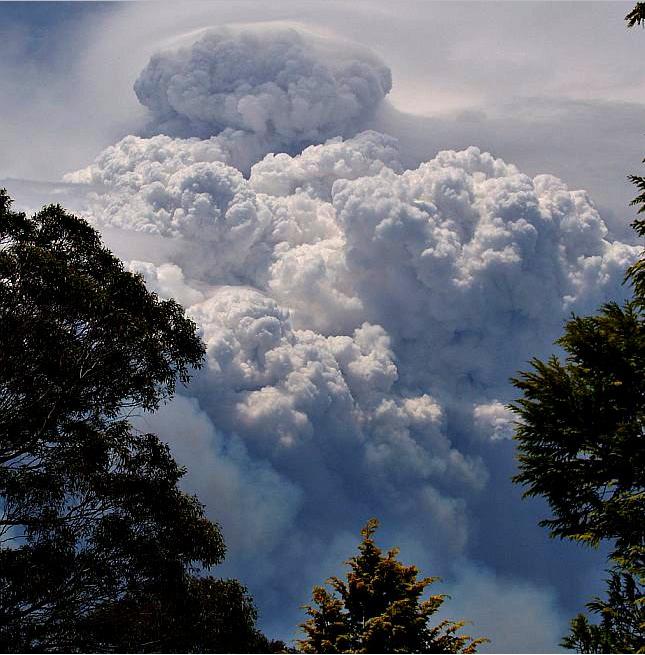