It’s Autumn in the Greater Blue Mountains, and the New South Wales Government’s bush arsonists are out in full swing deliberately setting fire to native habitat at every opportunity. Governmental ‘Habitat Reduction Season‘!
Is this pastime not comparable with the antiquated British imported tradition of the ‘Duck Season‘ – killing NATIVE ducks that is – just for sport. It’s the very same time of year!
“Capital climes for rough shooting old sport, what! Live on peg, we ought to bag a few dozen before tea.”
On Monday 25th March 2024, the NSW Government’s National Parks and Wildlife Service (NPWS) published a media release about its continuing “hazard” reduction burns across the Blue Mountains National Park. It read as follows (main extracts):
“The NSW National Parks and Wildlife Service (NPWS) has announced plans for an 850-hectare hazard reduction burn in the Glenbrook area of Blue Mountains National Park, set to commence on 26 March, weather conditions permitting. This preventive measure is part of a strategic effort to reduce the risk of wildfires and protect surrounding communities.
Scheduled to unfold over consecutive days, the operation targets the reduction of naturally accumulated fuel loads in the park. The primary aim is to provide strategic protection for the residential areas of Glenbrook, Lapstone, and Mulgoa against potential future wildfires.
…This burn is a component of the comprehensive hazard reduction program carried out by NPWS each year, often in collaboration with the Rural Fire Service and Fire and Rescue NSW. These operations are crucial for managing vegetation fuel loads and reducing the intensity and spread of potential wildfires.
The planned hazard reduction burns in Blue Mountains National Park underscore the ongoing commitment of NSW authorities to wildfire risk management and community safety. By taking proactive measures to manage fuel loads, the NPWS aims to mitigate the impact of wildfires, ensuring the protection of both natural landscapes and residential communities.”
Our comments to this bush arson justification spin doctoring:
The above is bush arson propaganda by contracted consultants with Communications Degrees, justifying the perpetual decimation of Australia’s native habitat since the first day of colonisation and usurpation of the continent since 1788. Nothing has changed or is likely to. Surviving intact wilderness has become reduced to mere islands. Just go to Google Maps [See our extract map below]
“850 hectares” is an area equivalent to about 30km x 30km (√ 850ha). In relative terms, that’s three times the size of Sydney’s CBD, a native habitat area capacity for many fauna;
“preventive measure is part of a strategic effort to reduce the risk of wildfires” – this is because when wildfires do occur the NSW Government invariably fails to (A) detect, (B) respond and (C) extinguish the ignitions promptly whilst small and controllable. It has an attitude that native habitat has a lower value than human habitat. In contrast, the urban Fire and Rescue Service is tasked to (B) respond and (C) extinguish the ignitions involving human property immediately, and unlike their unpaid volunteer Rural Fire Service (RFS) counterparts, they get paid to do it;
“protect surrounding communities” – this means human communities that have been built encroaching more and more into and usurping native habitat. These human “communities” are the only focus of the NPWS and its support RFS. Under this culture, wildlife communities matter not, irrespective of any threatened species impacted/killed. This attitude belies an antiquated anthropocentric mentality. Neither the NPWS nor the RFS employ an Ecologist. They just don’t care about protecting Ecology – in this case forest ecology;
“the operation targets the reduction of naturally accumulated fuel loads in the park“. That’s right, the NPWS as delegated custodial organisation ‘manager’ of the Blue Mountains National Park treats native habitat and its dependent fauna within such national parks in NSW (one of some 800) instead as “fuel loads” to be reduced to sterile urban park status. NPWS should be relegated to managing urban parks like Hyde Park in Sydney’s CBD;
“The primary aim is to provide strategic protection for the residential areas of Glenbrook, Lapstone, and Mulgoa against potential future wildfires.” – this is a reinforcement approach of our Point 3;
“…This burn is a component of the comprehensive hazard reduction program carried out by NPWS each year, often in collaboration with the Rural Fire Service and Fire and Rescue NSW.” – this is a reinforcement approach of our Point 3;
“These operations are crucial for managing vegetation fuel loads and reducing the intensity and spread of potential wildfires.” – “crucial” for whom? An expanding Sydney human housing sprawl? So the NSW Government’s volunteer and under-resourced RFS has less forested native habitat risk and so less work to do in the event of wildfires because year-on-year there is less forested native habitat left. Perpetuation that long term strategy, there will eventually be little or no native habitat left across NSW. So down the track a future NSW Government may well decide that the RFS is therefore no longer needed and so make the organisation redundant. Sydney that has been deliberately morphed by successive governments (state and federal) into the ‘Greater Sydney Region‘ has, on paper, swallowed whole the ‘Blue Mountains Region‘ (see NSW Planning map below) , presuming its world heritage status is now just outer-upper western Sydney parkland for the rezoning offing. Allowing the 2019 megafires to incinerate 80% of the Greater Blue Mountains World Heritage Area, clearly has achieved the NSW Government’s intended devaluation of the UNESCO recognised “Outstanding Universal Value” of all the Eucalypts, and is wholly consistent with a usurpation agenda for an even Greater Sydney megalopolis.
“The planned hazard reduction burns in Blue Mountains National Park underscore the ongoing commitment of NSW authorities to wildfire risk management and community safety. By taking proactive measures to manage fuel loads, the NPWS aims to mitigate the impact of wildfires, ensuring the protection of both natural landscapes and residential communities.” The spin doctoring clearly by outsourced consultants with Communication Degrees is palpable here. It’s more repetition of contrived persuasive terms: “planned hazard reduction burns”, underscore the “ongoing commitment of NSW authorities to wildfire risk management and community safety”. Ask the residents of Mount Wilson who lost their homes by RFS reckless arson in 2019 on this point! “taking proactive measures to manage fuel loads”, “the NPWS aims to mitigate the impact of wildfires”, “ensuring the protection of both natural landscapes and residential communities.” What so burning the natural landscapes to protect them? Seriously? In truth it is all about avoiding bad publicity when the RFS lights a high risk fire on 14th December 2014 causing homes to be incinerated like at Mount Wilson. “The state coroner has confirmed that a bushfire that destroyed homes in Mt Wilson, Mt Tomah, Berambing and Bilpin in December 2019 was caused after a planned RFS backburn jumped Mt Wilson Road.” [SOURCE: ‘Bushfire inquiry: Mt Wilson backburn to blame‘, BMG, 2nd April 2024]
RFS MOUNT WILSON ARSON: Sam Ramaci, like several of his neighbours, claims a back-burn lit by the RFS on December 14, 2019, was responsible for the destruction of his cool room, tractor and the property that was to fund his retirement. “If they hadn’t started the back-burn, my house would be still standing,” he said. (The NSW Government has refused to compensate him and others (nor even apologise) for the reckless misjudgment of its RFS – a NSW Government agency. Who can afford a class action? [Go to Video Link]
The Mount Wilson fire was the sixth backburn to escape along the southern containment line that was intended to protect the upper Blue Mountains from the Gospers Mountain Fire.
What sane person would join the Rural Fire Starters?
Bush arsonists have a psychological compulsion to set fire to see fire . It’s a ritual – they’re eyes light up. “Behold, The Fiery Cross !...”
NPWS is beholden to NSW Planning
A headline environmental protection agency that is supposed to be caring for national parks reporting to a state land use planning authority (aka Development). Is this a warped governmental portfolio conflict of interest of what? Liberal-Labor-Liberal…? Same Same.
The Regional Map of NSW according to the NSW Government’s Department of Planning and Environment fiefdom in 2024. Note that the Blue Mountains Region no longer exists, but has become annexed by the ever expanding ‘Greater Sydney Region’ in the mindset of Macquarie Street’s urban expansionism campaign. Mount Victoria a Sydney suburb now? Lookout Broken Hill!
Deforestation of Australia since colonisation and its usurpation from 1788. Remnant native forests and their native habitat have been decimated to ecologically unsustainable islands. The entire pre-colonial eastern seaboard of the continent was originally blanketed by native forests unbroken, extending about 600km inland. [SOURCE Google Maps – satellite view, April 2024]
It’s no wonder that Australia continues its record of perpetuating the world’s worst rate of wildlife extinctions. It’s akin to countries like Madagascar. It’s all hell bent on serving the Human Plague Order, currently 8.1 Billion! and in 2024 growing (and demanding more) by $75 million p.a. The current population of Australia is 26,654,200 as of Monday, April 29, 2024. Compare Australia’s Federation census of 1901 counted 3,773,801 people across Australia. [Check: Census Bureau Projects U.S. and World Populations on New Year’s Day; and ^https://www.worldometers.info/world-population/]
But wait there’s more bush arson planned…
An update last Friday, 26th April 2024 (just days ago), the NSW Government’s environmental department website again posted a media release advising of its further planned “Hazard reduction burn in Blue Mountains National Park” for the weekend.
It read as follows:
“The NSW National Parks and Wildlife Service (NPWS) with assistance from the NSW Rural Fire Service is conducting a hazard reduction burn in Blue Mountains National Park starting Sunday 28 April, weather permitting.
Staff from Metro South West and Blue Mountains regions undertaking the Pisgah Ridge hazard reduction burn near Glenbrook in the Blue Mountains National Park The hazard reduction burn will focus on an area south of Woodford, in the mid-mountains, and cover a total area of about 400 hectares. The burn aims to reduce fuel hazards and assist in the protection of property in the surrounding Woodford, Hazelbrook and Linden areas.
Fire trails around the burn area, including Bedford Creek, will be closed to the public, along with the Murphy’s Glen camping and day use area. The campground will be reopen when it is safe to do so.
Smoke may be seen in the area for up to a week after the initial operation.
The burn is one of many hazard reduction operations undertaken by NPWS each year, many with the assistance of the NSW Rural Fire Service (RFS) and Fire and Rescue NSW.
All burns around the state are coordinated with the NSW RFS to ensure the impact on the community is assessed at a regional level.
People with known health conditions can sign up to receive air quality reports, forecasts and alerts via email or SMS from the Department of Climate Change, Energy, the Environment and Water. For health information relating to smoke from bushfires and hazard reduction burns, visit NSW Health or Asthma Australia.
More information on hazard reduction activities is available at NSW Rural Fire Service and the NSW Government’s Hazards Near Me website and app.”
Asthma sufferers? – NSW Government care factor?
Carbon emissions? – NSW Government care factor?
10th December 2019: NPWS world heritage Eucalyptus woodsmoke enveloping Sydney from what started as an abandoned pile burn off Army Road near Gospers Mountain in the distant Wollemi NP two months prior on 26th October 2019. She’ll be right, eh NPWS boss David Crust?
The RFS is one of the planet’s highest emitters of airborne carbon particulates by way of causing mass wood-smoke by repeatedly lighting bushfires and ignoring wildfires. Wood smoke we feel is a tad more polluting than humans exhaling carbon dioxide. But then how many humans on the planet?
Yet the climate change cult remains quiet on this more serious global problem. Why so selective about a lesser pollutant in the hysterical ideology that has morphed from ‘Global Warming‘ (Wallace Smith Broecker’s term of 1975) to ‘The Greenhouse Effect‘ (Mike Hulme’s term in 1994) to ‘Climate Change Scientology‘ (U.S. National Academies of 2014) to currently ‘Climate Crisis‘ actually predating the former (U.S Vice President Al Gore of 2007).
The RFS and NPWS press on regardless – as it’s not carbon dioxide, so all good!
Here’s the latest bush arson schedule to further set fire to the still unburnt native habitat of the Blue Mountains:
RFS:“It’s ok love, it’s good for the bush. She’ll be right.”
It’s an age old mentality of the fox charged to look after the chickens. Both the NPWS and RFS have a cultural attitude that the national parks are NOT to be protected, despite the NPWS delegated to so-called manage NATIONAL parks across New South Wales (NSW). That is despite the Rural Fire Service (RFS) charged with putting out wildfires.
That perverted culture is conditioned to regard native habitat only as a ‘fuel’ that burns and so NOT habitat but a ‘hazard’ to be controlled and burned to prevent it burning. If there is no habitat left, then the meathead rationale, no hazard, so job done! Of recent times the spin doctors in government seconded as contractors with Communications Degrees (aka the art of spin) have softened the community sell of these ‘hazard reductions’ to ‘prescribed burns” to justify and take some noble authority from on high that the BUSH WAS ORDERED TO BE BURNED, WE HAVE NO CHOICE !
All their fire trucks are filled with more flammable liquids light a bushfire than water to put it out. ‘RFS’ should stand for for Rural Fire Starters.
Blue Mountains World Heritage?
Eventually the bush grows back but with a vastly different flora community make up. The biodiversity is gone. The wildlife don’t come back from the dead.
One of countless Koalas tragically burned to death in her native habitat during the Blue Mountains megafires of 2019. They won’t come back. [This website is not suitable for children to view]
This native Koala would have looked something like this:
National parks throughout Australia over the 236 years since colonisation and its continent-wide deforestation, land use destruction and introduced bushfires, have consistently and hatefully made Australia’s ecological landscape very very quiet and devoid of wildlife.
The 2019 mega bushfires of NSW that the NPWS and RFS let get out of control over months, wiped out 80% of the Greater Blue Mountains World Heritage Area, including rare remnant koala communities and hosts of other at-risk wildlife and their special native habitat that NPWS has no clue of the statistical losses. NPWS does not manage, it mismanages, else just oversees politically drive projects like multi-million dollar tourists track upgrades to benefit humans. The NSW State Government tasked to look after UNESCO world heritage on behalf of the Australia Government?
This habitat reduction regime is to burn the remaining 20% that didn’t cop the 2019 wildfire megablaze. They call this “stewardship”? All trust in the NSW Government to protect world heritage has long gone out the window.
The ‘NPWS’ is a misnomer
‘NPWS” is an abbreviation for the National Parks and Wildlife Service in the state of New South Wales.
Logo of the NPWS
The problem is that this government bureaucracy is supposed to be the governmental (public) custodian for national parks is misleading:
NPWS is not national, rather it is only a NSW governmental sub-department. Governmental ‘management’ of national parks is not national, rather each state and territory has its own national parks, and the Australian Government is not involved – so a bizarre and misleading naming tradition;
NPWS does NOT look after wildlife. Native habitat in these ‘national parks’ is supposed to be protected. Yet every year vast selected areas are burnt deliberately else left to burn on a grand scale, so killing wildlife and destroying their habitat.
As a consequence, the NPWS deserves to be more appropriately renamed as ‘NSW Parks Service‘ just like in Victoria, the Victorian Government calls its equivalent ‘Parks Victoria‘.
On the relevant NSW Government’s website pertaining to its NPWS, it explains that the NPWS is part of a sub-department called ‘Environment and Heritage, which in turn:
“Environment and Heritage is part of the Department of Climate Change, Energy, the Environment and Water.
Our vision is for a thriving, sustainable and resilient New South Wales.Environment and Heritage works with communities, businesses and governments to protect, preserve and strengthen the quality of our natural environment and heritage. We do this through active stewardship that supports a healthy New South Wales.We are committed to creating thriving environments, communities and economies that benefit the people of New South Wales.”
The three most trendy feel-good terms above include: “thriving”, “resilient” , active stewardship”. Pure motherhoodism by the contracted young spin doctors with a Communications Degree. So where are the published wildlife regional extinction stats before and after the Blue Mountains 2019 megablaze?
Recall Tathra Sunday 18 March 2018, the consequence of the RFS deliberately lighting a bushfire on a 38 degree Celsius (100 Fahrenheit) gusty day upwind of this coastal village. [Read Our Article: ‘Bushfire Scenario Was Not Rocket Science‘
[8] ‘Impact of the 2019-20 Mega-Fires on the Greater Blue Mountains World Heritage Area, New South Wales‘, 20221129, by P Smith and J Smith, Issue Vol. 144 (2022), Proceedings of the Linnean Society of New South Wales, ^https://openjournals.library.sydney.edu.au/LIN/article/view/17079
On Sunday 18th March 2018, the weather in Bega and nearby coastal Tathra was forecast to be a very hot 38 degrees Celsius, low humidity and high westerly gusting winds. So a Total Fire Ban was appropriately declared the afternoon prior by New South Wales Rural Fire Service Commissioner Shane Fitzsimmons. The Fire Danger Rating was set locally to just “High”.
Around midday a fire started on or near the rural property at 580 Reedy Swamp Road, situated about 8km SE of Bega on the western edge of the Tanja State Forest, with the outskirts of Tathra situated on the eastern edge just 4km downwind.
When will the ignition source be published so devastated Tathrans learn the truth?
It was a simple fire in bushfire terms. It started adjacent and upwind of state forest bushland in hot windy conditions and kept going in the same direction as the wind blew it until the wind dropped. It was wholly predicable, not rocket science. So the circumstances are indeed suspicious, but we expect a cronyistic cover up.
The nearest bushfire brigade is the Tarraganda Fire Shed on Tarraganda Lane about 6km NW of the ignition site, but government expects local volunteers to respond on standby, under-resourced to defend their community last minute with no financial compensation.
Four kilometres east is the outskirts of Tathra along Thompson Drive across the Bega River. This is locally referred to as the Tathra River Estate – a Bega Council approved satellite suburb invading remnant native habitat.
The Chronically Avoided Questions
There was no lightning, so what was the ignition source on this day of declared Total Fire Ban?
How long did it take the RFS to discover the fire after its estimated ignition time?
How did the RFS learn about the ignition? Proactive real-time geo-stationary low-orbit satellite with infrared camera or just a reactive public call to ‘000’?
How long did it take the RFS to arrive on site to suppress the fire? We’re talking mum and dad volunteers here, apparently arriving on the fire ground at 12:43pm to do squat.
What is the point of having fire trails throughout the Tanja State Forest if when there is a bushfire emergency, they are too dangerous to use?
When did the RFS realise that the gusty winds would spot embers over the Bega River and impact Tathra? When the embers spotted over the river?
What bushfire preparations and asset protection zones had been in place for Tathra, if any?
Given that Tathra was obviously bushfire prone, which homes were Bushfire Attack Level assessed and compliant?
Where was the RFS Erickson S-64 Air-Crane purpose designed helicopter Elvis with its 9,500 litre water dumping capacity?
Where was the RFS C-130 Thor with its 44,000 litre water dumping capacity? It cruises at 540kph, so from its base at Richmond it could have been deployed and effective over the active fire edge imminently set to impact Tathra within an hour – 360km as the crow flies! – if they were military standard professional.
The under-resourced pre-1939 volunteer model for the bushfire fighting is a repeated failure
Another Promised Wildlife Sanctuary Goes Up In Smoke
So the fire was left to burn into the Tanja State Forest because, according to the RFS cultural scarce resource mindset, it was not immediately threatening property. She’ll be right. A bit of unauthorised hazard reduction wouldn’t go astray. What habitat?
The fire was only incinerating the flora reserve which provides habitat for one of the last Koalas communities along the Sapphire Coast. The RFS dubbed the fire the Reedy Swamp Fire or the Tarraganda Fire. Residents were only advised to “Watch and Act”, whatever that means.
Then mid-afternoon the wind picked up as per the usual diurnal wind variation profile. So with 38 degrees Celsius and 30 kph plus nor-westerly winds, the fire raced out of control through dense bushland toward the western outskirts of Tathra on the coast. At no time did the fire front change direction. It was heading towards Tathra from the outset.
Incident logs from Sunday show Fire and Rescue NSW, a state government agency, offered additional emergency brigades and assistance at 12:34pm in response to a flood of Triple Zero calls from the area. Those offers were declined before the agency attempted to offer more crews again at 12.58pm – again being rejected.
RFS Deputy Commissioner Rob Rogers said while the fire was burning in remote mountainous terrain, “it would have been dangerous to have [Fire NSW] there”.
The purpose of fire trails? Habitat reduction.
Rural Firefighting Dysfunction
She’ll be right. It was only at 3.40pm that authorities from the Rural Fire Service did request extra help, issuing a priority request for all available assistance, as the fire front rapidly approached Tathra.
Shortly after 2.30pm the bushfire intensified as winds picked up. By 4pm the fire had hit Tathra and NSW Rural Fire Service volunteers warned residents it was too late to leave.
But it wasn’t the 7km bushfire front misreported by the media. The early spread of the bushfire started at around 500m wide and then spread to about a 1500m wide front, spotting ahead as it was fanned by the gusty WNW winds. The bushfire front tracked from the ignition near Reedy Swamp downwind 7 km toward Tathra Head at the coast. The only thing seriously stopping the bushfire was the weather or the sea.
RFS deputy fire commissioner Rob Rogers said the bushfire quickly got out of control after it started yesterday afternoon. “It jumped very quickly to a place called Thompson Drive and that was where the first home was impacted and it just really quickly ran then into the main part of the town,” he said.
By 4:38 pm the RFS was reporting: “EMERGENCY WARNING – Reedy Swamp fire (Bega LGA) – Fire impacting on #Tathra. Seek shelter. It is too late to leave.”
What is the point of having a Catastrophic rating if it isn’t used?
Deputy Commissioner Rogers said dealing with nature was not always “an exact science”. “There has been dozens of hazard-reduction activities in that area,” he said. “There was one that was only two or three years’ old and the fire went straight through that burn as well.
This time 65 homes, 35 cabins and caravans destroyed, and dozens more damaged. Only last January the Tathra Launderette caught fire and destroyed the premises as well as the adjoining Bliss Stylists hairdresser and Little Bottler Tathra Cellars.
But criticism is taboo because the government sends in volunteers, who are automatically beyond reproach. The politicians are very quick to remind us at every bushfire aftermath.
Different Fire, Same Incompetence
The RFS in hindsight are reporting it as “catastrophic” and “a perfect storm”. It’s frankly a bit late Shane Fitzsimmons and are they now furiously shredding their communication records?
“It will never be the same again,” said Renata Boulter, a Tathra resident of 26 years.
Trust government’s used and abused volunteer force with your livelihood?
The insurance damage bill will be in the hundreds of millions, again, and that ignores the human, livestock and wildlife cost ignored by a sound bite media. Ina few weeks the ghoulish media filming amongst the ruins in their shiny hi-vis wear will have packed up and moved on.
It’s another Dunalley (Forcett bushfire) (2013), another Yarloop (2016), another Mundaring (2018), another Marysville (2009), Canberra (2003), Cockatoo (1983), Anglesea (1983), Hobart (1967), Leura (1957). On each occasion, the bushfire had been not threatening houses and so wrongly left to burn in some cases for days, then the wind picked up in the afternoon as it usually does and it was all too late.
And the lawyers will no doubt be getting in for their pound of flesh, just like Maurice Blackburn profited $100 million in fees out of the victims of Victoria’s 2009 Black Saturday bushfires. Tathra victims would be well advised to read up on Garry Angus, Kinglake victim, who suffered $4.2 million in economic losses. But after six years trustful waiting, Maurice Blackburn offered him a compensation cheque for $120,000. He sent it back to them in disgust. The lawyers also exposed the victims compensation to a $20 million tax liability – so the government to a cut from the victims compensation as well.
“The whole thing was flawed right from day one. The $494m (for Kilmore East-Kinglake victims) that they settled on was never going to be enough to help people. It needed to be three times that amount.”
(Read Postscript below).
Disaster Waiting to Happen..again
The western outskirts of Tathra, known as Tathra River Estate, bore the brunt of the bushfire. It was subdivided and developed and built out from 2013. The NSW Government Department of Planning and Infrastructure and the Bega Council happily approved the ‘Planning Report: State Environmental Planning Policy No. 71 (Coastal Protection) Master Plan: Tathra River Estate, dated June 2012.
Concerns over the current inadequacies of bushfire access was raised during submissions, as the well as the cumulative impact of additional dwellings and the need for emergency access in the event of a bushfire.
Many of the residential houses decimated by the fire were built between the 1960s and 1980s, in cheap and nasty asbestos. No bushfire tolerance. She’ll be right.
The provision of Asset Protection Zones, connection to the fire trail network and emergency access around the edge of the development apparently addressed many of the concerns. It was then up to Bega Council “to consider other matters in a bushfire emergency strategy.” What did Bega Council do or not do? We suspect cronyistic developer corruption.
The NSW RFS raised no objection to the Master Plan. Yesterday, Tathra River Estate (Thompson’s Drive or Estate) as well as similarly recently approved housing subdivisions extending into the native bushland such as Wildlife Drive and Sanctuary Place, bore the bushfire frontal attack.
It’s called ‘Wildlife Drive’ for a reason.
The residential development encroaches upon Tanja State Forest – established in 2017 to protect wildlife
There is shared culpability here, and how did they get home and contents insurance?
Tathra River Estate/Thompson’s Estate (bottom right of image) – juxtaposed next to Tanja State Forest
(This is an old image – more development has been allowed since)
It costs $20,000 a day to keep the Elvis air crane on stand-by and an additional $11,000 a day to operate. This extrapolates to $11 million a year to have Elvis ready and able to seriously suppress bushfires. Sounds like a lot of money but the economic loss and emotional cost besetting Tathra residents?
In 2015, the NSW Rural Fire Service unveiled its latest fire fighting weapons, including a monstrous-sized former RAAF C-130 Hercules converhuman ted water-bombing tanker capable of dropping up to 44,000 litres of water on any bushfire any time. It costs a bomb, but what cost Australian livelihoods?
The official economic cost of the Dunalley (Forcett) bushfire was $100 million, the Yarloop bushfire $45 million, Marysville $300 million and Canberra $300 million.
Melbourne University’s follow up study into the human aftermath of Victoria’s 2009 Black Saturday bushfires reported a quarter of survivors still experiencing serious mental health problems six years later, including affected children. (Read report below under Further Reading’)
“The reality of the disaster and its aftermath formed the ongoing backdrop of children’s daily lives. Children from a very young age through to older youth experienced anxieties and upheavals at home, in school, in sport, in friendship groups and in the community.
“She had so much trouble going back to school. She couldn’t think, concentrate at all. Everything seemed irrelevant that she was doing and they tried so hard. They were very helpful but she had a lot of trouble with just fitting in with the kids that she knew before there. They weren’t understanding her and she just felt that all their problems were very trivial.”
(Parent)
Photo by Ngaire Walhout
Lessons To Be Blocked by Cronyism..again
Of course there will be another government enquiry, so the government is seen to given a damn. There are the same number of government enquiries as there have been bushfire tragedies since the Black Friday back in 1939. It concluded – “Mistakes We’re Made”, and then the report gets filed and bushfire fighting returns to business as usual and set to repeat history.
The 1939 Black Friday fires in Victoria burned almost two million hectares, claimed 71 lives and destroyed more than 1,000 homes, including entire townships. In adjusted terms, these fires cost some $750 million.
On 1983 Ash Wednesday fires in Victoria and South Australia claimed 75 lives, more than 2,000 homes and over 400,000 hectares of country. Total property losses were estimated to be over $400 million. Between 1967 and 1999, bushfires in Australia resulted in 223 deaths and 4,185 injuries, and a total economic cost of more than $2.5 billion. Victoria’s Black Saturday in 2009 cost $4.4 billion and 173 lives.
For Tathra yesterday, it could and should have been responsible, militarily heroic, and quite beautiful – professional fire suppression like Sydney gets, where emergency professionals have proper resources at their disposal, are properly remunerated, and so residents entrust the firies to save their homes and family.
Where was it parked this time?
In 2017 the NSW Government delivered a $4.5 BILLION surplus, so they are not exactly struggling.
Tathra is a microcosm of Victoria’s bush-enclosed Mornington Peninsula coastal residence west of Rosebud; timber and fibro shacks enveloped in a tinder dry tea-tree forest – in a bushfire Forest Fire Danger Index scary scenario – another catastrophic crematorium waiting to happen.
What does the land manager National Parks Service say about Tanja State Forest? It is part of the Murrah Flora Reserves which encompasses 4 areas covering nearly 12,000 hectares and include Murrah, Mumbulla, Bermagui and Tanja flora reserves along the New South Wales Sapphire Coast. The Murrah Flora Reserves were created in March 2016 and are significant to the local Aboriginal Yuin People who own neighbouring Biamanga National Park. They also provide an important conservation role, as habitat for the last significant koala population on the NSW South Coast and other threatened species, such as the long-nosed potoroo, yellow-bellied glider and the powerful owl.
Of course it was “overgrown”. It’s called wildlife habitat. And firies, it’s scarce and valuable and worth defending. It is not expendable. yet another 1200 hectares of native habitat set aside for supposed sanctuary has been incinerated. It was a defacto RFS hazard reduction again gone wrong.
NSW National Parks and Wildlife Service:
“The national and state forests within the Sapphire Coast are home to some of the most iconic views and breathtaking landscapes in Australia. The South Coast’s outstanding national park system offers visitors a wide choice of opportunities to discover spectacular landscapes, from dense forests to quiet, solitary beaches; from cool, silent rainforests to colourful, alpine wilderness wildflowers. The national parks a diversity of unspoiled habitats and ecosystems which offer refuge to unique, and often ancient, plants and animals found nowhere else on Earth.”
Hypocrites!
Koala in the Murrah Flora Reserve, probably incinerated. Photo by David Gallan.
Source: Far South Coast Conservation Management Network
“I’ve lost the value of my business, I’ve lost everything.”
Garry Angus and Anne Salmon on a block they own outside Kinglake. Photo by Stuart McEvoy
‘As cheques from the record-breaking Black Saturday class actions finally began flowing to bushfire survivors in December, many of the victims welcomed the payments as the end of another chapter in their emotional and financial recovery.
Not Garry Angus. He, with an unquantified number of the thousands of claimants who joined the lawsuits, remained angry about Maurice Blackburn’s handling of the cases. The accountant from Pheasant Creek, just outside Kinglake, decided to put his money where his mouth is and sent back his cheque for $120,000.
Now he is launching a website for fellow survivors to register their complaints about Maurice Blackburn’s administration of the settlement scheme. He hopes support from other aggrieved claimants will bolster his bid for a judicial review of the $494 million Kilmore East-Kinglake settlement and the $300m settlement for the Murrindindi-Marysville fire, announced in 2014 and 2015 respectively.
“The only winners out of this have been Maurice Blackburn,” Mr Angus said. “The whole thing was flawed right from day one. The $494m (for Kilmore East-Kinglake victims) that they settled on was never going to be enough to help people. It needed to be three times that amount.”
Like a number of other bushfire survivors who have spoken publicly, Mr Angus is angry at the fees Maurice Blackburn has stripped from the settlements — more than $100m — and the Australian Taxation Office’s claim that the firm has acted unusually to expose the funds to a tax liability of about $20m. He is also furious at how his case was personally handled, claiming that the firm was lax in communicating with him, and only junior staff dealt with him (even misspelling his name on his formal assessment notice).
Before the February 2009 bushfires, Mr Angus owned and managed an accounting firm that employed eight people. He owned four investment properties around the Kinglake area, losing two completely to the blaze.
He brought a 2000-page tome of his financial records with him to his meeting with assessor Neil Rattray, and says the barrister was clearly overwhelmed and admitted he might not be the best person to handle this complex case.
Mr Angus’s claim for $4.2m in losses — largely based on future earnings from his firm, which he closed while struggling with post-traumatic stress disorder in the fires’ aftermath — was dismissed by Mr Rattray. The barrister did not accept he would suffer from any future loss of earnings or earning capacity, arguing that his business had been struggling and there was “no real suggestion” the company would be successful in the future.
In a submission to Supreme Court judge Jack Forrest, who oversees the Kilmore East settlement scheme’s administration, Mr Angus has accused Maurice Blackburn of failing in its duty of care, and asked for an independent review.
Maurice Blackburn has stood by the assessment, saying Mr Angus missed his chance to formally request a review (for which the firm charges $3800 if the finding is against the claimant).
“Given Mr Angus never objected or asked for a review during the assessment process, it’s an odd protest to now hand back a substantial cheque because of a desire to obtain more money,” a spokesman said.
Mr Rattray told The Australian he could not comment on Mr Angus’s claims, but in the reasons for his assessment, he noted that Mr Angus had treatment for depression and panic attacks before the bushfires. Since the fires, he has been suicidal at times, needing extensive medical treatment and occasional hospitalisation.
“It has psychologically scarred me for the rest of my life,” Mr Angus said. “I’ve lost the value of my business, I’ve lost everything.’’
Location of Oxley Wild Rivers National ParkClick image to enlarge – note the patchy dark green of remnant forests
[Source: Satellite Map – Google Maps]
.
The ‘Macleay River’ Bushfire (Oct 2012)
.
Macleay River Bushfire October 2012
– left to burn for a week from 12th Oct 2012 because not a threat to private property
..then the wind picked up…unbelievable!
.
Over the past month, a single contiguous area covering some 60,000 hectares of vegetation has been left to burn by bushfire. That equates to 600 km2 or roughly 25km x 25km.
Much of what has been burned is/was of World Heritage values within the included Oxley Wild Rivers National Park. This is unacceptable custodial neglect.
If this was Sydney, this is the black boxed area that would have been incinerated:Putting this 60,000ha bushfire into a Sydney urban perspective
Professional urban fire fighting would not allow 60,000 hectares of private property and human lives to burn
– such would historically dwarf the Great Fire of London.
.
The Rural Fire Service has labelled the bushfire the ‘Macleay River Fire‘. But it began as two separate bushfires on or before 12 October, nearly a month prior. One was then labelled ‘Georges Junction Fire‘ and the other ‘Freds Creek Fire‘, both purportedly ignited by bush arsonist(s). Seven days later, the Georges Junction Fire has burnt an estimated 8,931 ha, while the then much smaller Freds Creek Fire had burnt 1,688 ha. By the time the combined bushfire was extinguished 60,000 hectares had been burned, much within the World Heritage Area..
This is yet another classic case of bushfire neglect primarily by the delegated custodians of the National Park and World Heritage Area – the New South Wales National Parks and Wildlife Service. Is this due to chronic lack of resourcing; and/or symptomatic of a disturbing rationalist culture that believes that burning Australian vegetation, even ancient rainforest, could be somehow beneficial to biodiversity.
Remote ignitions go undetected, then unsuppressed, until many days later, bushfire weather conditions worsen and the fires get out of control, combine and destroy vast areas of important Nationl Park and World Heritage.
This 2012 Macleay River Fire is like the ‘2006 Grose Valley Fires‘ of the Blue Mountains repeated to script.
The Australian Government continues to be ultimately culpable for gross neglect in failing to protect its custodial listed natural heritage.
The Rural Fire Service has learnt to avoid accusatioins of incompetence by routinely removing timely records on its websites about the operational response in the days at the start of the ignitions. Details about the timings of ignition detection and initial suppression are deliberately withheld from the public.
The following bushfire updates are mainly from second-hand news media. A notable recurring theme across these news reports is that the media interest and the target of the fire fighting effort, just like in urban fire fighting, is to save humans lives and property. This is not a bad thing, but the glaring omission is the lack of interest in suppressing the bushfire in the National Park and World Heritage.
The Rural Fire Service policy and operational strategy is such that if human lives and properrty are not directly threatened by bushfire, then a bushfire is allowed to continue burning, irrespective of whether it is burning through National Park or World Heritage. Since the Rural Fire Service has the same terms of reference as the professionaly paid New South Wales Fire Brigade, then they are essentially doing the same urban job.
The only reason the Rural Fire Service exists in less populated rural areas instead of the professionaly paid New South Wales Fire Brigade, is traditionally so that the Australian Government and New South Wales Government can save money by relying on unpaid, under-resourced volunteers. Yet the environment in rural fire fighters work in is inherently more dangerous, demanding and in need of sophisticated resources for military-speed detection and suppressions of bushfires.
.
21 Oct: Bushfire Update
.
‘Blazes burn out of control: Permits suspended as hot, dry weather hits North West’
Satellite infrared image of the fire called Georges Junction inside the Oxley Wild Rivers National Park
Having already burnt out a massive 14,000 hectares and is likely to join up with the Freds Creek fire.
The active edge of the fire shows up bright yellow; the red areas are the burnt areas.
(Photo by New England RFS)
.
<<Two massive bushfires in the Oxley Wild Rivers National Park were basically running unchecked yesterday because of adverse firefighting conditions, incident controller for the New England bushfire emergency, Allyn Purkiss, said.
Mr Purkiss said the two Section 44-declared fires one named Freds Creek and the other Georges Junction were likely to join up yesterday and burn out a total of 30,000 hectares in the coming weeks.
“They took a big run under strong winds (on Saturday)..The fires had started after landholder burns had got away”, Mr Purkiss said.
..The fire named Freds Creek, which started on October 12, had burnt out 3,189 hectares and was crowning at 4am yesterday, with flames jumping from treetop to treetop.
“It means it’s very uncontrollable very dangerous conditions,” Mr Purkiss said yesterday.
The RFS had been unable to aerial-bomb the fires because of gusty winds. Mr Purkiss described it as “nigh-on impossible” to water-bomb in those conditions.
Instead, RFS volunteers had concentrated on saving property. He said it was hard to tell how many homes and remote-area shacks might be affected.
“We’re still trying to come to terms with that. We could have up to 50 in the area: there are shacks all through this country,” he said.
Mr Purkiss said the other fire, Georges Junction, had already burnt out 14,000 hectares. (Ed: Same as the 2006 Grose Valley Fires).
He said conditions in the New England RFS zone were “fairly similar” to strong, gusty winds on Saturday. “The forecast is for 50km/h winds by late afternoon,” Mr Purkiss said.
No homes had been lost in either fire yet. “None that we know of,” he said. The RFS was doing a “fairly extensive reconnaissance of the area”, he said.
Three other fires one about 40km east of Guyra, one near Walcha and one near Ebor had also started since Friday.
The Guyra fire, which started on Saturday, was located in the Mt Mulligan/Wards Mistake area.
Locals had alerted the RFS to the fire, which was in “very remote country … it’s difficult to get to no roads, no trails”, Mr Purkiss said.
“I’ve tasked an aircraft to get out there today and map it and give us some intel (intelligence),” he said..
“No properties were under threat: it was burning in scrub.“
.
Mr Purkiss said he was “not sure” how much land had been burnt out he would have to wait for information provided by the aircraft crew.
The Walcha fire, called Panhandle and in the Enfield State Forest, had burnt out five hectares by the time it was contained by mid-afternoon on Saturday.
The Ebor-area fire was located “in an area we can’t get to”, Mr Purkiss said. “We’re flying to map it today,” he said yesterday.
It had also burnt out five hectares.
“Local landholders and Ebor RFS assisted in containing it,” he said.
Mr Purkiss said the New England RFS zone was unlikely to lift its suspension of fire permits today.
“While ever we have a bushfire emergency like this going, all permits are suspended we’re already dealing with enough fires, so we don’t need any more mistakes giving us grief than we already have,” he said.
Mr Purkiss said this season had already started to play out differently compared to the past three years.
In the past three fire seasons, rain had usually come along and helped extinguish any fires but this season was different, with many more periods of extended dry weather.
“In talking to the local staff, they say that this (Georges Junction) is the largest fire they have had since 2009,” Mr Purkiss said. “We’re working hard to get it done. We thank the volunteers and employers for allowing us to fight these very large fires.”>>
<<Fire continues to threaten properties near Oxley Wild Rivers National Park after two blazes combined yesterday.
The Macleay River bushfire had already burnt about 20,000 hectares early yesterday afternoon as more than 30 firefighters battled the out of control blaze, NSW Rural Fire Service spokeswoman Bridie O’Connor said.
The inferno may have posed a threat to properties between Georges Junction and Five Day Creek, particularly on the Carrai and Fitzroy Tablelands and on the Macleay River in the vicinity of Lower Creek and Comara, Ms O’Connor said early yesterday afternoon.
“We’re looking at a minimum of six hours before some properties might be affected,” she said. “People should expect to see smoke and fire and be alert.”
Hot and windy conditions over the weekend (20th and 21st) saw the fires at Georges Junction and Freds Creek combine.
The Georges Junction fire, near Cochrane State Forest, which started on October 12 had burnt more than 14,859 hectares and was still burning out of control when it met with the Freds Creek fire early yesterday afternoon. The fire at Freds Creek was being controlled yesterday afternoon after three State Forest groups joined the NSW Rural Fire Service to use bulldozers to create fire breaks earlier in the week.
Meanwhile, the Armidale to Kempsey Road between Waterfall Way and Bellbrook was closed on Saturday and Sunday because of the fires.
The Rural Fire Service was concentrating its efforts on establishing containment lines.
People on properties near Georges Junction and on the Macleay were urged to be alert for fire warnings.>>
.
23 Oct: Bushfire Update
.
‘Total fire bans expected back in place by Thursday’
<<…Adverse weather conditions on Sunday hindered attempts to subdue two massive bushfires in the Oxley Wild Rivers National Park. Fire crews were reduced to protecting property on the ground and the two fires merged late on Sunday as fire crews battled from the ground to protect property, unable to water bomb due to gusty winds across the region.
The fire, now named the Macleay River Fire had burnt out 28,733 hectares as of last night, Inspector Brett Loughlin, public liaison officer for Armidale Section 44 with the NSW Rural Fire Service, said.
Mr Loughlin was expecting the fire to burn out more land.
“We’re doing some mapping now and expect it to be around that 30,000-hectare mark,” he said. He said 52 firefighters were on the ground creating firebreaks, doing backburning and helping protect the property of landholders living within a few kilometres of the fire front.
“There are properties in close proximity,” Mr Loughlin said. “The fire has flared up a little this afternoon and some embers are falling around properties in the Lower Creek area.
“No property is under threat at the moment … the fire’s not doing anything like it was doing on Saturday (when it was out of control – a day of hot, gusty westerly winds).”
Five helicopters are currently tasked to water bombing the Macleay River Fire.
Oxley Wild Rivers National Park is still shut to the public…>>
<<Rural Fire Service forensic investigators have interviewed a ‘person of interest’ as the battle to contain the Macleay River fire enters its 15th day.
RFS investigators from Kempsey and Coffs Harbour arrived yesterday to investigate the possible cause of the blaze in the Oxley Wild Rivers National Park which has since burnt out 33,160 hectares of bush and pasture land.
RFS Public Liason Officer Inspector Brett Loughlin said all major fires were investigated as a matter of cause and investigations were ongoing.
Around 80 firefighters from the NSW RFS, FRNSW and NPWS, supported by five aircraft and four bulldozers are fighting the fire, which has a 247 kilometre perimeter.
Ember attack on properties around the Lower Creek area were reported yesterday but Inspector Loughlin said that firefighters were working with local landholders to protect at-risk homes.
Inspector Loughlin said that good containment lines had been established by fire crews in the last 24 hours and today “aerial incendiary” work by helicopter would be carried out on the south western side of the blaze. “It’s still an active fire but we’re starting to get a handle on it,” Inspector Loughlin said.
The Macleay River Fire is the culmination of the ‘Freds Creek Bushfire‘ and ‘Georges Junction Bushfire‘ that had merged last weekend. The fire is burning in the vicinity of the Comara, Georges Junction, Five Day Creek, Lower Creek, Blanches Creek and Smith Creek areas.
Another fire burning near Guyra, has been contained. The ‘Mulligans Bushfire‘, which has burnt out 3207 hectares near the Guy Fawkes National Park has been burning since Saturday.>>
Macleay River Bushfire
(Photo by Sean Bremmer)
.
1 Nov: Bushfire Update
.
Rural Fire Service Reported Operational Statistics:
‘MACLEAY RIVER FIRE‘
ALERT LEVEL: Advice
LOCATION: 50 kms east of Armidale, 75 kms west of Kempsey, 65kms east of Walcha
COUNCIL AREA: Armidale Dumaresq
STATUS: Being Controlled (Ed: glass half-full spin)
TYPE: Bush fire
FIRE: Yes
SIZE: 51,405 ha
RESPONSIBLE AGENCY: Rural Fire Service
UPDATED: 1 Nov 2012 15:25
<<Three local government areas have been declared natural disaster zones in the wake of a major fire that has been raging in northern NSW for two weeks.
The massive front formed on October 21 when the Freds Creek and Georges Junction fires combined at the Macleay River. It has damaged over 51,000 hectares of:
National Parks
State Forests
Private Land
.
across three shires:
Armidale Dumaresq shire‘
Walcha shire
Kempsey shire
.
“These fires have been burning in the area for a number of days and due to the conditions, they merged into one large fire, jumped containment lines and threatened numerous properties,” Emergency Services Minister Michael Gallacher said in a statement on Monday.
“This declaration triggers a number of disaster assistance schemes to assist with the cost of disaster relief and recovery.”
Over the last two weeks, bushfires have raged across the New England and Mid North Coast regions. Other fires under this declaration include the Clay fire in Armidale Dumaresq, the Panhandle fire in Walcha and the Mulligans fire in Guyra on the western side of Guy Fawkes National Park, which has burnt over 3,400 hectares of National Park and private land.
Mr Gallacher said the Macleay River fire had damaged significant portions of the Oxley Wild Rivers National Park, which is part of the Gondwana Rainforests of Australia World Heritage Area, a series of protected areas which were first inscribed on the World Heritage List in 1986 and extended in 1994.
.
5 Nov: Bushfire Update
.
<<Three separate fires burning out of control south-west of Casino since the weekend have been contained, the Clarence Valley Rural Fire District reports.
The ‘Dubadar Creek Bushfire‘, which was believed to have been started by arsonists before blowing out from 50ha to 300ha on Saturday, was contained on Sunday and was extinguished at midday today, the district’s incident controller Stuart Watts said.
Two separate blazes, also deliberately lit, at Mt Pickabooba 4km from the Dubadar Creek fire were expected to be contained by this afternoon following back-burning, Mr Watts said. The Rural Fire Service had 10 fire trucks, 19 personnel and two bulldozers working to bring the fires under control on the weekend. The Northern Star has approached the police for comment.
The battle with the blazes come as NSW Police and Emergency Services Minister Michael Gallacher declared natural disasters for the Mid North Coast – parts of which only a year ago were receiving the same declaration for floods – and New England areas.
“The main focus of this declaration is the Macleay River Fire, which developed on 21 October 2012 as the culmination of the Fred’s Creek and Georges Junction Fires,” Mr Gallacher said in a written statement.
“These fires have been burning in the area for a number of days and due to the conditions, they merged into one large fire, jumped containment lines and threatened numerous properties…Firefighters have been working hard to create containment lines around the Macleay River Fire to protect properties as the fire approaches.
“As of 1 November 2012, the Macleay River Fire continues to burn and is estimated to have damaged over 51,000 hectares of National Parks, State Forests and private land across the three LGA’s of Armidale Dumaresq, Walcha and Kempsey.
“The Macleay River Fire has damaged significant portions of the Oxley Wild Rivers National Park, which is part of the Gondwana Rainforests of Australia World Heritage Area, a series of protected areas which were first inscribed on the World Heritage List in 1986 and extended in 1994.“>>
.
Reader Comment:
by ‘coco50’ from Ballina 20111105:
<<When is our judicial system going to get serious about arsonists? It is difficult enough to catch them. Think about what they do. They destroy natural bushland and animal habitat. They put the lives of people at risk or even cause deaths. They destroy property which causes hardship and suffering and years to rebuild. This pushes up everyone’s insurance premiums. They out emergency services personnel at risk.
But when we get an arsonist in court, the defence counsel makes an argument like: “My client had a difficult childhood – his parents and peers didn’t understand him. He is remorseful”
The Judge almost cries while handing out a “slap on the wrist” sentence. It is much harder to start a fire in jail while you are doing 20 years time. Lock them up!>>
‘MACLEAY RIVER BUSHFIRE’
ALERT LEVEL: Advice
LOCATION: 65km East of Walcha
COUNCIL AREA: Armidale Dumaresq
STATUS: Being Controlled
TYPE: Bush fire
FIRE: Yes
SIZE: 59, 663 ha
RESPONSIBLE AGENCY: Rural Fire Service
UPDATED: 6 Nov 2012 09:10
.
Oxley Wild Rivers National Park is World Heritage‘protected‘
.
1986: Gondwana Rainforests of Australia inscribed on the World Heritage List.
.
World Heritage Listing because local people thought it was so important to save before it was gone
.
Over twenty-five years ago, in 1986 the Gondwana Rainforests of Australia, then called the Central Eastern Rainforest Reserves of Australia (CERRA), were inscribed on the World Heritage List for their outstanding natural universal values.
Theses rainforest comprise the Great Escarpment of eastern New South Wales, then known as the Australian East Coast Sub-tropical and Temperate Rainforest Parks, were inscribed on the World Heritage list meeting the following three World Heritage Natural Criteria:
Outstanding example representing significant ongoing geological processes and biological evolution (World Heritage Natural Criterion viii)
Outstanding example representing major stages of the earth’s evolutionary history (World Heritage Natural Criterion ix)
Containing important and significant habitats for the in situ conservation of biological diversity (World Heritage Natural Criterion x)
The Gondwana Rainforests contains the largest and most significant remaining stands of subtropical rainforest and Antarctic Beech (Nothofagus moorei) cool temperate rainforests in the world, the largest and most significant areas of warm temperate rainforest and one of only two remaining large areas of Araucarian rainforest in Australia.
Enormous Antarctic Beech (Nothofagus moorei)
At Cobark Park, Barrington Tops, 50 metres tall
.
The Gondwana Rainforests of Australia is a serial property comprising the major remaining areas of rainforest in southeast Queensland and northeast New South Wales. They include the most extensive areas of subtropical rainforest in the world, large areas of warm temperate rainforest and nearly all of the Antarctic beech cool temperate rainforest. Some of the oldest elements of the world’s ferns and conifers are found here and there is a concentration of primitive plant families that are direct links with the birth and spread of flowering plants over 100 million years ago.
A wide range of plant and animal lineages and communities with ancient origins in Gondwana, many of which are restricted largely or entirely to the Gondwana Rainforests, survive in this collection of reserves. The Gondwana Rainforests also provides the principal habitat for many threatened species of plants and animals.
The area is one of the best places on earth to see ancient ferns and Araucaria such as Hoop Pines.
Hoop Pine
(Araucaria cunninghamii)
Found naturally in the dry rainforests of New South Wales and Queensland and in Papua New Guinea.
The trees can live up to 450 years and grow to a height of 60 m.
.
Rainforest once covered most of the ancient southern supercontinent Gondwana and remains the most ancient type of vegetation in Australia. The Gondwana Rainforests provide an interesting living link with the evolution of Australia. Few places on earth contain so many plants and animals which remain relatively unchanged from their ancestors in the fossil record.
Due to two centuries of colonial deforestation across New South Wales and Queensland – timbergetting, ‘land clearing’ for agriculture and housing – the reserves of rainforest that comprise The Gondwana Rainforests in discontinuous patches, surrounded by fireprone eucalypt forest and cleared agricultural lands.
These patches range in size from tiny gully stands to lush forests covering large valleys and ranges. Collectively, these ‘serial sites’ despite their small size and scattered fragments, provide proximity and interconnection by corridors of semi-natural habitats and buffers. Their natural asset value is fragile and demands intensive management and protection in order to preserve their ecological integrity.
The ecosystems of the Gondwana Rainforests contain significant and important natural habitats for species of conservation significance (World Heritage Natural Criterion x).
The Gondwana Rainforests provides the principal habitat for many species of plants and animals of outstanding universal value, including more than 270 threatened species as well as relict and primitive taxa. Many of the rare and threatened flora and fauna species are rainforest specialists, and their vulnerability to extinction is due to a variety of factors including the rarity of their rainforest habitat.
The Gondwana Rainforests also protects large areas of other vegetation including a diverse range of heaths, rocky outcrop communities, forests and woodlands. These communities have a high diversity of plants and animals that add greatly to the value of the Gondwana Rainforests as habitat for rare, threatened and endemic species. The complex dynamics between rainforests and tall open forest particularly demonstrates the close evolutionary and ecological links between these communities.
Species continue to be discovered in the property including the re-discovery of two mammal species previously thought to have been extinct:
The Hastings River Mouse (Pseudomys oralis)
Parma Wallaby (Macropus parma)
Parma Wallaby (Macropus parma)
Endemic to rainforests and sclerophyll forests in New South Wales from the Watagan Mountains in the South to the Gibraltar Range in the North.
Parma wallabies were thought to have become extinct a century ago until being discovered again in the 1970s.
.
1994: Oxley Wild Rivers NP added to World Heritage
.
In 1994, large extensions of rainforests across south-east Queensland and New South Wales including the Oxley Wild Rivers National Park were added to the World Heritage listed Central Eastern Rainforest Reserves of Australia (CERRA), now entitled The Gondwana Rainforests of Australia (since 2007).
OxleyWild Rivers National Park – location map
[Source: Google Maps]
.
These reserves comprise almost 50 separate remnant reserves of unspoilt rainforest wilderness stretching from north-east New South Wales (the Oxley Rivers region) up through south-east Queensland. Each of these reserves contains important nature conservation values in its own right, however the full significance of the property becomes evident only when viewed as a whole, and collectively CERRA provides a significant network of habitats for many of Australia’s rare and endangered species.
Since 1994, the Australian Government in co-operation with both the New South Wales and Queensland Governments have recognised the need for coordinated, consistent and cooperative management, to ensure that the integrity of CERRA‘s values is protected. At the time, the World Heritage Committee requested the Australian Government complete management plans of individual sites. Six years later in 2000, the Australian Government published its ‘Strategic Overview for Management for the Central Eastern Rainforest Reserves of Australia to guide co-operative management by the three Governments in relation to the identification, protection, conservation, rehabilitation and presentation of the Gondwana Rainforests. In 2002, a Technical and Scientific Advisory Committee and a Community Advisory Committee were established.
The Gondwana Rainforests of Australia are managed principally by the New South Wales National Parks and Wildlife Service (part of the New South Wales Department of Environment and Climate Change) and the Queensland Environmental Protection Agency.
Later 1,850 ha of Winterbourne State Forest, also known at the Big Lease, was added to the reserves wilderness. Currently (2012), the remaining 1,560 ha of Winterbourne and 1,075 ha of Enmore State Forests are to be added to the National Park. Further inclusions include Green Gully headwaters and 1,439 ha of leasehold land in the lower Chandlers River gorge.
The Macleay Gorges Wilderness Area, covering 50,000 hectares, was declared World Heritage in 1996 and further extended in 1997.
In 2007, Macleay Gorges Wilderness Area and Oxley Wild Rivers National Park, along with the 50 separate Crown Land reserves of remnant ancient rainforest were collectively renamed under the umbrella term Gondwana Rainforests of Australia to better reflect their World Heritage values. These include important rainforested areas between Newcastle and Brisbane from Mount Royal National Park and Banrrington Tops National Park to Lamington National Park inland of Queensland’s Gold Coast.
Aspley Falls in flood
Oxley Wild Rivers National Park
.
High waterfalls crashing into steep gorges are spectacular examples of an important ongoing natural process – erosion. Erosion by coastal rivers created the Great Escarpment and the steep-sided caldera of the Tweed Valley surrounding Mount Warning. This towering mountain was once the buried plug of an ancient vast volcano. Today, rainforest grows on the fertile, well watered soils that remain.
The Macleay River on the Mid North Coast of New South Wales, Australia, has the world’s second-fastest flowing currents during flooding, when it can hold over 200,000 gigalitres.
Its headwaters flows from the Gara River on the eastern side of the Northern Tablelands near the tonwships of Armidale and Walcha. Key tributaries are the Chandler River, Styx River and Apsley River as well as the Tia River, Dyke River and Yarrowitch River, which pass through a number of spectacular gorges and waterfalls in the Oxley Wild Rivers National Park.
The Macleay River flows 400km south-east through Kempsey and into the Pacific Ocean at South West Rocks. Upon colonial discovery in the 1820s; the ancient, tall native Red Cedar (Toona ciliata) forests were completely deforested.
Australian Red Cedar Forest
Tamborine National Park, Gold Coast Hinterland, Queensland
(such trees have long been logged through the Oxley Rivers region)
.
In 1976, the Apsley Macleay Gorges were identified as being of ‘true wilderness quality‘.
At that stage the public protection offered to the area was limited to two small reserves in the south, and a few local council run recreation areas at popular sites such as Wollomombi Falls, Dangars and Apsley Falls. With future land-use undecided, the NSW Electricity Commission began surveying the Apsley Valley for a hydro-electric scheme in the late 1970s. The Apsley Gorge National Park of 6,718 hectares was gazetted followed by the 3,456 hectare Yarrowitch Gorge National Park soon after.
In 1989 East Kunderang Station of 30,400 hectares passed to the National Parks and Wildlife Service (NPWS) and was proclaimed the Oxley Wild Rivers National Park.
.
Rich Wildlife through Oxley Wild Rivers National Park
.
Oxley Wild Rivers National Park is rich in fauna, with over 350 species recorded, including 55 mammals.
It is a major refuge for the Brush-tailed Rock-wallaby (Petrogale pencillata), with the largest confirmed population in the Green Gully area of Yarrowitch.
.
Brush-tailed Rock Wallaby (Petrogale penicillata) in Oxley Wild Rivers National Park
This species is listed in New South Wales as ‘Vulnerable to extinction’, but that was by the NSW Scientific Committee in 2003, nine years ago
There have been two major bushfires through since then – one in 2009 and now in 2012
How many viable individuals have been lost to the Macleay River Bushfire – does the NSW NPWS know or care?
.
<<Oxley Wild Rivers National Park, including Green Gully Track, is closed until further notice due to wildfire.>>
Over 173 bird species, 38 reptile and 19 amphibian species have been recorded in Oxley Wild Rivers National Park.
Skinks, goannas, tortoises, lizards, snakes, frogs and fish occur in the park, particularly on the river flats. A number of fish species have been recorded. Notable, is the speckled longfin eel (Anguilla reinhardtii), which breeds in the ocean with the juveniles eventually returning to the Apsley–Macleay River system.
There are fourteen known threatened species within the Oxley Wild Rivers National Park:
All these wildlife were previously widespread, but now are vulnerable to extinction or worse; which has become an Australian cliché, but at the same time an indictment on Australians.
But how much of this protected wilderness region is left after last fortnight’s bushfire catastrophe?
How can it be deemed to be protected, when bushfire is allowed to ravage it and its vitally recognised flora and fauna? Was the World Heritage Area allowed to burn as a convenient bushfire management operational defacto Hazard Reduction? There were no human assets at risk. It was wilderness and so out of sight out of mind…such is the dominant bushphobic culture of the Australian and State Governments, so accused of neglect and incompetence after the 2009 Victorian Bushfires that killed 173 people.
To current anthropocentric (20th C babyboomer) governments, this ‘Macleay River Fire’, irrespective of its World Heritage ecological protection, is blanketly and culturally dismissed as just another hazardous fuel region to target within Australia’s continent-wide Government Arson strategy. Successive generations will revisit this prevailing cultural mindset of ‘hazard reduction‘ and cast it alongside 19th C ‘timbergetting‘ and 20th C ‘clearfelling‘.
In the Blue Mountains, some 40,000 hectares of native vegetation is currently approved by the same Australian and New South Wales Governments for deliberate burning.
If deliberately setting fire to the native vegetation is committed privately it is deemed bush arson and so attracts a poultry 14 years gaol or less even less, despite people having been burned to death as a direct consequence.
But if deliberately setting fire to the native vegetation is previously prescribed by Government, then participants are artificially deemed legally immune and impune from criminal liability, even if the prescribed bushfires they light get out of control, which is all too frequently.
The Australian Government’s official public relations message reads:
Institutional arrangements for the protection and management of Gondwana Rainforests are strong. The property is made up of 41 reserves, almost all of which are within the protected area estate, and primarily managed by the Queensland Parks and Wildlife Service and the New South Wales National Parks and Wildlife Service. Both States have legislation relating to protected areas and native flora and fauna that provide protection for the values of the Gondwana Rainforests.
All World Heritage properties in Australia are ‘matters of national environmental significance’ protected and managed under national legislation, the Environment Protection and Biodiversity Conservation Act 1999. This Act is the statutory instrument for implementing Australia’s obligations under a number of multilateral environmental agreements including the World Heritage Convention. By law, any action that has, will have or is likely to have a significant impact on the World Heritage values of a World Heritage property must be referred to the responsible Minister for consideration. Substantial penalties apply for taking such an action without approval. Once a heritage place is listed, the Act provides for the preparation of management plans which set out the significant heritage aspects of the place and how the values of the site will be managed.
National Heritage is also a matter of national environmental significance under the EPBC Act.
Importantly, this Act also aims to protect matters of national environmental significance, such as World Heritage properties, from impacts even if they originate outside the property or if the values of the property are mobile (as in fauna). It thus forms an additional layer of protection designed to protect values of World Heritage properties from external impacts.
The impacts of climate change and high levels of visitation, undertaking effective fire management, and mitigating the effects of invasion by pest species and pathogens present the greatest challenges for the protection and management of Gondwana Rainforests.
Climate change will impact particularly on those relict species in restricted habitats at higher altitudes, where particular microclimatic conditions have enabled these species to survive.
Management responses include improving the resilience of the property by addressing other threats such as inappropriate fire regimes and invasion by pest species, and trying to increase habitat connectivity across the landscape.
[Source: Australian Government, ^http://www.environment.gov.au/heritage/places/world/gondwana/values.html]
.
Recall 2009: 9,500 hectares of Oxley Wild Rivers left to burn
.
In December 2009, a lightning strike started a bushfire in the Youdales Hut area of the Oxley Wild Rivers region. The hut was unaffected (human property?), but 1,500 hectares of inaccessible steep country was burnt out before it was brought under control.
Another lightning strike started a large bushfire in the Reedy Creek region of the park. This fire has burnt out over 8,000 hectares of rough country.
.
[Ed: Yes, steep wilderness terrain without convenient fire trails carved through it, is naturally inaccessible to lumbering urban fire trucks – so RFS/NPWS where were the waterbombing aircraft on 12th Oct 2012, when the fires were tiny and manageable?]
In Berridale, New South Wales, in the north-west foothills of the Australian Alps, there are hardly any trees left now. Generations of colonists have clearfelled forests of Australian Snow Gums en mass for ‘high country’ beef pasture.
Each Autumn when the bored local Rural Fire Service (RFS) is searching for something to justify its funding, it sets fire to the natural landscape on the basis of doing so being a bushfire ‘mitigation strategy‘. ‘Burn the forest before it burns’. Last month the Berridale RFS burned grasslands and the few surviving isolated old snow gums, and even the odd homestead by accident.
.
“We burned to death 100,000 Japanese civilians in Tokyo – men, women and children. LeMay recognized that what he was doing would be thought immoral if his side had lost. But what makes it immoral if you lose and not immoral if you win?”
~ Robert McNamara (Architect of the US War Against the Vietnamese’)
.
‘Berridale is a small country town in the famed Snowy Mountains ‘high country‘ of Australia, just a short trip from Australia’s highest peaks (Australian Alps) – about 60km from Mount Kosciuszko.
Vast grassy slopes and pastoral plains surround Berridale these days, all cleared by our forebears. Yet one can still find traces of the old country, dotted by ancient magnificent granite boulders holding old fella wisdom of the original people of this land. It was for eons blanketed by wild twisted Snow Gum forests and grand and rugged rivers coursed through this area giving vital sustenance to the diverse species of this place. Traditional Aboriginal people hold insight to the links between plants, animals and their surroundings.
Bucolic British..’Berridale’
..replicated in New South Wales
Australia (other side of planet)
.
The Northern Corroboree Frog and Lesueur’s Tree Frog are long gone away from long-clearfelled Berridale.
.
‘When one can no longer hear the frogs,
Nature has stopped breathing and has passed away.’
( Ed. – a metaphor to my aunt who passed away this morning)
.
So once again, the Rural Fire Service has lit fires around Berridale, lighting fires so that they may save the town from bushfires…“We had to destroy the village in order to save it”
Over recent weeks the Rural Fire Service across New South Wales has lit multiple fires it euphemistically labels as ‘hazard reduction‘ – any rich ground cover that may provide habitat foir groudn dwelling mammals is deemed a fuel and therefore a hazard. It must be therefore burned before it burns. The fires the RFS light are ‘prescribed burns‘, they precribe that a bushfire must be started so they start one.
It is like an arsonist deciding it is a good idea to light a bushfire and so lights one, like Brendan Sokaluk did at Churchill in Victoria on 7th Febuary 2009. The only difference is that because the RFS is a government funded agency it has legal immunity – read ‘impunity‘.
On 5th September, it was reported that ‘about 50 grass, scrub and bushfires have burned across NSW during a tough start to the bushfire season.’
Included was a scub fire in Budderoo National Park, near Kiama, burning out of control. It was one of those prescribed burns that had escaped.
So the reports read that crews from the NSWRFS and National Parks and Wildlife Service were using waterbombing aircraft to contain the fire, which was burning in inaccessible terrain, as if it was a wildfire that had started by lightning, not deliberately. It is almost like they light fires to create work for themselves, and destroy vast areas of bushland in the process.
.
Snow Gums do not enjoy being burned to death
So then the RFS declares a Total Fire Ban across most of New South Wales, so that residents don’t their barbeques in case they start a bushfire.
The hazard reduction burn at Berridale, burned out 200 hectares of largely grassly scrubland, taking with it old snow gums that must have been a few hundred years old in come cases.
A historic homestead was destroyed in the blaze. It was a lucky escape for Brian Woodhouse’s elderly mother, who was in the Myack homestead as the fire approached.
“She’s 86 years old and suffers dementia,” Mr Woodhouse said.
“This has been her home for all her life and this is the only place that she has got a touch of reality. Here at her home she knows where everything is.”
Mr Woodhouse said passers-by saved his mother’s life.
“One of the carers came around that day to have lunch with her and had just left after lunch,” he said. “She only travelled about 2 kilometres and she could see the fire, so she did a U-turn and raced back and got her out, with the help of a couple of the young Snowy River Shire Council guys.”
This immorality of setting fires seems extracted straight out of Robert McNamara’s military operating and debrief manual.
.
Snow Gums in their natural alpine environment
[Source: vjmite, TrekEarth.com]
.
Footnote
.
“We had to destroy the village in order to save it” is an infamous quote by US Army Major Booris in 1968 in the immediate aftermath of the Tet Offensive by North Vietnam forces.
It has come to symbolise the absurdity of war and the United States immoral prosecution of the Vietnam War. The quote was made famous by its reporting by a young Associated Press reporter, Peter Arnettwho had been assigned to report on the battle of Ben Tre during the Tet Offensive. For two days, a small American unit had battled the Vietcong, who in turn had killed many villagers. Arnett entered Ben Tre after it had finally been secured and interviewed a number of Army officers.
The following is believed to be the true account:
.
Saving Ben Tre: About the famous quote of the Vietnamese 1968 Tet Offensive: “We Had To Destroy Ben Tre In Order To Save It”
.
‘I was the Commanding Officer of Task Force Builder, an Army engineer group of 60 soldiers that was stationed in the small rural village of Rach Kein, Vietnam in 1968. Rach Kein was approximately 20 miles SW of Saigon, located in Long An Province. Our base camp was next to the base camp of the 3/39 Infantry Battalion of the 9th Infantry Division.
Ben Tre, Vietnam, is a moderately size town that is located on the Mekong River about 25 miles SE of Rach Kein. It was much bigger than Rach Kein, probably even bigger than the town of Long An.
During the first week of the Tet Offensive the VC made their big move of attacking Saigon. The 3/39 Inf. was initially sent to fight in the big battle for Saigon. This left us alone to face an NVA regiment of 5,000 men that surrounded us on January 29. We survived that. And we remained surrounded and cut off for several weeks. As best I recall, the 3/39 Inf. was in Saigon for about two weeks. I certainly remember this, because while they were gone from Rach Kein we were on our own as far as defending against ground attacks. These must have been likely, for at one point, the 9th Inf. Div. sent in several companies of the 2/39 Inf. to bolster the town defenses and to conduct sweeps around Rach Kein while the 3/39 was away.
I especially remember that one platoon of infantry was wiped out in a well laid ambush in an open rice paddy. It was just a few hundred yards from where we eventually built a school near the first village North of Rach Kein (can’t remember its name). The VC had cleverly built machinegun bunkers into the rice paddy dikes (it was the dry season), and the infantry walked right up to them before the VC opened fire.
Then the 3/39 returned. Or I should say that 75 percent of them returned. The fighting in Saigon had been intense. After only a few days rest, they were air-lifted by chopper to retake the town of Ben Tre. Ben Tre had been occupied by the VC during Tet. The VC had dug in heavily, and were not ready to retreat without a big fight. So the still exhausted and depleted infantry troops of the 3/39 were thrown into another vicious fight. I cannot tell you how much respect that I have for those guys. True heroes, every one of them. Tough, plucky, and mostly draftees. I still remember my wonder at the ability of America’s youth to endure.
I sometimes wonder if I am the only one who remembers them. So I willingly tell this story, so you can help me to remember. Their deeds should not be forgotten. The 3/39 Inf. Bn. suffered 100% casualties during the year 1968. I watched it. It is something that still haunts me. Eight hundred young men gone, dying bravely to serve the country they so loved.
Anyway, the fighting in Ben Tre went badly for the Americans. House-to-house all the way. The VC were so well dug in and barricaded that progress got stalled. So, in desperation, artillery and air strikes were called in on the town. Much of the town was heavily damaged in the resulting melee, but the town was retaken.
Several days later, Major Robert Black (the Rach Kein U.S. Army Advisor) invited me to attend with him an evening briefing that the 3/39 was going to give for a group of journalists and Saigon army brass. I had never before been invited to attend an infantry battalion briefing. I accepted the invitation. The briefing was held in a Vietnamese house that served as the S-3 office. It was about 7 houses East of where the VC barbershop was at one time set up. The house was on the left side of the road as you drove through the infantry compound, just about across from the infantry mess hall.
Anyway, the living room of the house was packed, mostly with civilians. The purpose of the briefing was to explain the battle of Ben Tre. Such briefings are usually conducted by the S-3, in this case, Major Booris. He was a heavy-set fellow.
He was also not my favorite officer. This was because he was the guy who told the infantry on guard to open fire on us the morning when we were walking back to Rach Kein across the rice paddies. This was when we had chased the VC who had ambushed the infantry Road Runners that one infamous and well-remembered morning (but that is another story). Fortunately for us, the infantry sergeant (an E-5) on duty had ignored the major’s orders. I’ll never forget his grin as he told me that he had saved our bacon by ignoring the S-3’s orders. He could clearly see that we were friendlies, so he withheld his fire.
Anyway, at one point the journalists were pressing Major Booris to explain why it had been necessary to wipe out the town. They were definitely pressing the point that perhaps too much force had been applied by the US forces. Major Booris was trying his best to put a good face on the situation. But at one point he got flustered, and blurted out, “We had to destroy Ben Tre in order to save it.” I have to admit that I almost laughed when he said that. It was a really unfortunate comment. But Major Booris, in his defense, was trying his best to defend his battalion’s honor. His CO, Lt. Colonel Anthony P. Deluca, deftly jumped to his feet and interceded to rescue Major Booris from this difficult moment. He smoothly carried the rest of the conversation. I really liked LTC Deluca. He was a good combat leader, and he was always fair to Task Force Builder.
Anyway, that was the only briefing of the infantry that I ever attended. But it turned out to be the most famous. Some of the journalists present at that briefing seized Major Booris’ comment, and they really publicized it. As I recall, it appeared on the cover of Newsweek or Time magazine within the month. And it has gone down in history as an example of the some of the insanity that was Vietnam.
Last year I was reading an historical assessment of the Vietnam War. The famous historian who wrote it actually challenged whether or not that Ben Tre statement was ever made. Well I know, because I witnessed it being made. I wrote to the historian, explaining this. I hope that he got my message.’
Regards,
Michael D. Miller
Former Captain, US Army Corps of Engineers
Commander, Task Force Builder, 1968
46th Engineer Battalion
159th Engineer Group
The fire tragedy afflicted Australia’s legendary ‘Conservation Cradle’
A scorched Grose Valley from Evan’s Lookout, looking north up Govett’s Gorge
(Photo by Editor taken 20061209, free in public domain. Free Large Image)
.
A heritage tragedy unfolds
.
A simple lighting stike ignited remote bushland in rugged terrain within the Blue Mountains National Park, over 5km north of the township of Blackheath on 20061113.
Innocuously, the ignition started off on hilly Burra Korain Ridge,It was far from settlement but during relatively calm weather and low temperature, so it was not suppressed but ‘monitored’..then the wind picked up.
.
It and a second ignition west were allowed to continue burning for days until they eventually coalesced with compounded backburning into a firestorm some ten days later down in the Grose Valley. On 20061122, the prized Grose Valley and its iconic and precious Blue Gum Forest were incinerated under a pyrocumulus cloud of towering wood smoke that could be seen from the Sydney coast a hundred kilometres away. Some 14,070 hectares of National Park habitat was burnt. The tragedy did not so much as ‘strike‘ from the lighting itself, but as Blue Mountains residents we saw it ‘unfold‘ over many days and nights under the trusteeship of Bushfire Management.
.
..ten days later
The pyrocumulus cloud of a screaming, dying Grose Valley precious to many, including wildlife
The Grose Valley and its Blue Gum Forest and wildlife burning to death on 20061122
A greenhouse gas estimate was not taken.
.
Community shock, sadness and overwhelming sense of loss
.
How was this allowed to happen?
In the days that followed, many Blue Mountains residents and especially the many conservationists familiar with the Grose Valley and Blue Gum Forest over many years became deeply shocked at learning about the loss of this magnificent sacred preserved forest – its tall 300+ year old rare Blue Gums (Eucalytus deanii).
Without knowledge of personal accounts, one respects that the dramatic scenes of the smoke and fire inflicted personal trauma with many, given so many people’s long and established personal knowledge, affinity, love, awe and respect for..
‘The Blue Gum‘
.
The Habitat Advocate reaches out to these people (doesn’t matter the fact that years have passed) and we choose to express the view of a need to tell truths and to seek some sense of learned maturity from it all. For the Grose Valley contained many tracks, many walks and many special places if one knew where to look. Popes Glen and from Govetts Leap down under Bridal Veil following the popular Rodriguez Pass to Junction Rock then Acacia Flat and the Blue Gum Forest in the heart of the Grose. Many special places includes Beauchamp Falls, Docker Buttress, Pulpit Rock, Lockley Pylon, Anvil Rock lookout, Perrys Lookdown, Hanging Rock, Pierces Pass, Asgard Swamp, and the inaccessible Henson Glen and David Crevasse gorge.
To this editor, the return in 2007 to a previously sacred special, but incinerated Neates Glen was emptying in spirit. There was heartfelt shock and dismay by many local conservationists familiar with the iconic Blue Gum Forest who became deeply saddened by the tragedy.
Neates Glen, as it was But since incinerated, not by the wildife, but by deliberately lit ‘backburning’
.
Phone calls and emails were exchanged with many locals wanting to know the extent of the damage and whether ‘the Blue Gum‘ could recover. The original fire had been fanned westward from Burra Korain Head spotting along the Blackheath Walls escarpment, but then decended and burnt through Perrys Lookdown, Docker Buttress and down and through the Blue Gum. Deliberately lit backburns had descended and burnt out Pierces Pass (Hungerfords Track) through rainforest into the Grose and everyone had seen the pyrocumulus mushroom cloud towering 6000 feet above the Grose on the 22nd.
There was an immense sense of loss. The relatively small Blue Gum Forest, perhaps just several hectares, was unique by its ecological location, by its grand age and by its irreplaceability. The sense of loss was perhaps more pronounced amongst the more mature conservationists, now lesser in number, who knew its original saviours of the 1930s – Alan Rigby, Myles Dunphy and other dedicated bushwalkers who had championed to save it from logging 81 years ago.
The conservation heritage of The Blue Gum Forest dates back to Australia’s earliest conservation campaign from 1931For this reason ‘The Blue Gum Forest’ has been passionately respected as Australia’s ‘Cradle of Conservation’
.
The region is home to threatened or rare species of conservation significance living within the rugged gorges and tablelands, like the spotted-tailed quoll, the koala, the yellow-bellied glider, the long-nosed potoroo, the green and golden bell frog and the Blue Mountains water skink. Many would have perished in the inferno, unable to escape. The Grose is a very quiet and sterile place now, with only birds. But to the firefighters, these were not human lives or property.
.
Deafening silence from the ‘Firies’ naturally attractedcommunity enquiry and suspicion
.
The day after the firestorm that enveloped the Grose Valley, the wind subsided and from 20061123 through to the final mopping up date of 20061203, the 2006 Grose Bushfire and its many ember spotfires came under bushfire management control and were ultimately extinguished or else considered to be ‘benign‘.
It is important to note that during the entire bushfire event from 20061113 through to 20061203, only NSW Rural Fire Service ‘Major Fire Updates’ on its website and headline journalism appeared in the local Blue Mountains Gazette newspaper. Initially, the community, conservationists and ‘firies’ were respectfully passive. In the immediate aftermath of the fire from 20061204 through to the weekly issue of the Blue Mountains Gazette on 20061129, the local community, conservationists and ‘firies’ were letter silent in the paper. It was a combination of shock, preoccupation with the emergency and respectful anticipation of communication from the bushfire authorities.
One can assume here that given the scale of the tragedy, many in the Blue Mountains community were respectfully patient in anticipation of an assured announcement from Bushfire Management or some communication process. But none eventuated.
.
Injustice
.
The following weekly issue of the Gazette was published on 20061129, but no communication from Bushfire Management. Only dismissive bureaucratic statements came from Parks and Wildlife’s Regional Director Geoff Luscombe with a tone suggesting minimal damage and business-as-usual.
This was the article:
6th Dec: ‘Park managers take stock as smoke clears’
‘Hundreds of fire-fighters are celebrating a return to normality this week after cooler weather and an intense two-week campaign by volunteers and professionals brought a fire in the Grose Valley under control.
According to the Rural Fire Service this good weather, combined with a thorough mop-up operation and ongoing infra-red monitoring, means flare-ups are unlikely.However the 15,000 hectare burnt area – including the iconic Blue Gum Forest – is likely to remain closed for the “foreseeable future” due to safety concerns and regeneration.
Geoff Luscombe, regional manager of the National Parks and Wildlife Service (NPWS), said the fact that only part of the Grose Valley burnt meant many animals had been able to seek refuge.
“Many of the Australian plants and animal species have learnt not only to survive fire but to exploit it,” he said. However he confirmed fears that the fire had burnt Blue Gum Forest – a Mecca for bushwalkers and conservationists in the heart of the Grose Valley.
“Blue gums aren’t a particularly fire-tolerant species,” he said. “Fire last burnt through Blue Gum in 1994. The effects of this fire we don’t know yet and we may not know for many months to come.”
A botanist has been sent to inspect the area and there could be ongoing monitoring.Mr Luscombe did not wish to comment on how the fire was handled due to a lengthy absence, but Inspector Jack Tolhurst from the Blue Mountains District Rural Fire Service has warded off any potential criticism.
“I think at the moment we should be looking at the positive,” said Inspector Tolhurst. “The fire is contained . . . It’s been a very long campaign but at the end of the day we haven’t lost any property or lives and half the Grose Valley at least remains intact.”
A fire that broke out near Zig-Zag Railway last week has also been contained. [Ed. According to inside reports, Zig Zag Railway Station was accidentally firebombed by an aerial helicopter attempting backburning].
“We’ve had a lot of help from a wide range of people. We’ve had wonderful support from the community . . . it was a wonderful effort from everyone.”
Meanwhile the hard work has only just begun for another group of dedicated volunteers.Blue Mountains WIRES are expecting to rescue a number of fire-affected native animals in coming months as they wander into residential areas for food and water.
“The arboreal animals – possums and gliders – they come to grief,” said chairperson Greg Keightly. “Birds suffer heat stress and smoke inhalation. They’re going to be flying around bewildered.”
He said residents who see native wildlife in urban areas should keep pets inside, provide water off the ground in a place safe from predators, and avoid the temptation to feed wildlife.
“Things come up for months after fires,” said Mr Keightley.“Do ring us (4754-2946) if you thing something is injured or doing it tough,” he said.
The national park south of the Great Western Highway, and the lookout at Govetts Leap, are open to visitors.For information on closures call 4787-8877 or visit www.nationalparks.nsw.gov.au’
.
.
Mismanagement?
.
So the silence from the firies, from Bushfire Management and from the New South Wales Government ultimately responsible and accountable, was deafening. It was as if the entire Firie fraternity had gone to ground in a code of silence behind closed doors.
So naturally the community response was that something smelt fishy. This communication intransigence was a public relations blunder by Bushfire Management, to its detriment.
Then filtered out accounts of crazy operational mismanagement during the bushfire and of bush arson by the firies behind the roadblocks beyond the public gaze.
Rumours circulated that the initial ignition had been left for burn in the critical first few days of 13th November and 14th November up on Burra Korrain Ridge because it wasn’t right next to a road so that fire trucks could get to it. The fire had even been abandonned. Then the wind picked up and it spread. Airborne firefighting was not called in until a Section 44 incident declaration was effected on 15th November.
A second fire nearby to the west near Hartley Vale, purported also lit by dry lightning on 14th Nov, had attracted broadscale backburning from the Hartley Vale Road. But the backburn got out of control, ripped up the valley fanned by winds and crossed over the Darling Causeway on to the Blackheath Escarpment and the Upper Grose to join up with the first blaze. The onground evidence shows that this was a hazard reduction burn starting from alongside the Hartley Vale Road just east of the village of Hartley Vale.
Then came the account of senior bushfire management at the Rural Fire Service headquarters at Homebush ordering a ‘headburning’ a new 10km fire front along the south of the Bells Line of Road into the Grose Valley. Perhaps the NSW Government had stepped in demanding action. Perhaps RFS headquarters response was a series of overreactions, albeit too late and to be seen to be now ‘acting’ was only compounding the fire risk to the Grose . Apparently, the RFS Commissioner had even touted imposing a massive defacto hazard reduction north of the Bells Line of Road right though the vast wilderness of the Wollemi National Park, to somehow head off another fire on 20th November some 80km away north of Wiseman’s Ferry, but that strategy was rejected in a heated operational debate. [“The Wollemi National Park is part of the World Heritage Area and covers 488,620 hectares. Important values of the park include the spectacular wild and rugged scenery, its geological heritage values, its diversity of natural environments, the occurrence of many threatened or restricted native plant and animal species including the Wollemi pine and the broad-headed snake, significant plant communities, the presence of a range of important Aboriginal sites and the park’s historic places which are recognised for their regional and national significance.” – Wollemi NP Plan of Management, April 2001]
Even the Zig Zag tourist railway station was apparently accidently firebombed by an overzealous airborne firefighter starting backburning en mass
Then came the account of Blackheath residents who had their houses subjected to the risk of a deliberately lit backburn during the course of the bushfire. Despite the out of control wildfire being many miles to the north west of Blackheath, a broadscale backburn (some say is was really a ‘defacto hazard reduction‘) was lit along the fire trail below the electricity transmission line near Govetts Leap lookout. But it got out of control briefly and threatened to burn houses in Connaught Road. Indeed the entire Blackheath Escarpment fire from Hat Hill Road south through Govetts Leap Lookout and Ebans Head was started deliberately as a ‘strategic’ backburn.
Blackheath Escarpment completely burnt (top) for hectares, looking south from Hat Hill Road
(Photo by editor 20061209, free in public domain, click image to enlarge)
.
The rural property east of Hartley Vale where on 20070207 there was clear evidence of hazard reduction (HR)commencing only from the south side Hartley Vale Road, opposite.Eucalypts were burned only at the base, but further up the hill the tree crowns had been burned.The HR had quickly got out of control and then crossed over the Darling Causeway.
(Photo by editor 20070207, free in public domain, click image to enlarge)
.
Once two weeks had passed since the dramatic firestorm and with only silence emanating from Bushfire Management and the NSW Government, local people had had enough and they wanted answers.
Some 143 local yet disparate conservationists via ‘jungle drums’ met up, discussed the issue, united informally and agreed to go public. They informally formed the ‘Grose Fire Group‘ and contributed to a fighting fund some $1700 odd and became vocal. Two weeks after the Grose Valley Firestorm the Grose Fire Group managed a full page open letter in the local Blue Mountains Gazette on 20061206 on page 13. It was directed to the ultimate authority responsible and accountable for the Grose Fire Tragedy, the NSW Government. The Premier at the time was Labor’s Morris Iemma MP. The NSW Member for the NSW Seat of Blue Mountains as well as NSW Minister for Environment at the time was Bob Debus MP.
Those who valued the Blue Gum Forest challenged those responsible for its protection. The tragedy certainly stirred and polarised the Blue Mountains community. Conservationists naturally wanted answers, an enquiry, a review of bushfire prevention and management from:
NSW National Parks and Wildlife Service under the direction of Regional Director Geoff Luscombe
NSW Rural Fire Service under the direction of Commissioner Phil Koperberg
Blue Mountains Bushfire Management Committee aligned with Blue Mountains City Council and chaired by Councillor Chris Van Der Kley.
.
‘Grose Valley Fire – World Heritage takes a hit’
“The Blue Gum Forest, birth-place of the modern conservation movement, was badly damaged by the Grose fire on Wednesday the 22nd of November. If this precious forest was a row of houses, then there would automatically be a major investigation into how the fire was fought. The fact that this major loss of our natural heritage is only now becoming known is testimony to the prevailing attitudes of those controlled the media spin during this recent fire event,” said Keith Muir director of the Colong Foundation for Wilderness.
“Until today the overall perception from the media was that this fire was a good one. No houses or lives lost”, Mr Muir said.
“There where no media updates on the struggle to save Blue Gum. No the reports of success in saving fire sensitive rare plants and rainforests along the escarpment edge. All the media reports spoke of bushland burnt; not on the success of any strategy to minimise the impact on the World Heritage listed national park, while saving lives and property”, he said.
“The Blue Mountains National Park Fire Management Strategy 2004 sets out all the necessary actions to protect the natural environment, as well as life and property. Yet for some reason it appears at this stage that the fire was not fought according to that agreed Strategy, as far as its provisions on natural heritage were concerned”, said Mr Muir.
“Increased fire is a major threat to World Heritage values of the Greater Blue Mountains national parks. Unless we develop and implement better strategies to defend the bush, as well as lives and property, then climate change will make this threat much worse,” Mr Muir said.
“The fire management strategies and techniques undertaken during the fire need to be re-examined to ensure the diversity of the Blue Mountains forests is protected into the future,” he said.
“Future fire management requires the feedback that only an inquiry into the Grose Valley Fire can achieve. Such an inquiry should not be taken as a criticism of those involved in fighting fire. It is an opportunity to ensure that everyone stays on fully board with future efforts to minimise fire damages,” Mr Muir said.’
What exacerbated the conflict was not some much that the bushfire had got out of control and had raged through the precious Grose Valley per se, but it was more the defensive, aloof reaction by ‘Firies’ which escalated into a barrage of defensive and vocal acrimony against any form of criticism of the firefighters.
In the face of such palatable denial by the Firies,of any accountability the initial shock and sadness within the local community within days quickly manifested into outrage and anger, and even to blame and accusations.
Most conservationists however felt a right to question and seek specific answers from Bushfire Management about the Grose Fires, for lessons to be learned, for fundamental changes to be made to bushfire management policy, bushfire fighting resourcing and practices, all simply so that such a tragedy should not be repeated.
But the key problem was that the ‘Firies‘ adopted an ‘in denial’ approach to a community suffering loss. Many Firies denied that they had done anything wrong and rejected any criticism by conservationists. Some Firies vented their anger in the local media attacking anyone who dared criticise. Clearly, Bushfiore Management’s debriefing and review of the bushfire in its immediate aftermath was poorly managed.
Underlying the conflict was the Firies urban fire fighting mandate to ‘protect lives and property” – that is human ones, not forests, not wildlife. Whereas what emerged with many in the Blue Mountains community was the implicit expectation that the World Heritage Area is an important natural asset to be protected, including from devastating bushfire.
The Grose Valley Greater Blue Mountains World Heritage Area
.
Hence, it was a conflict between differing cultural value systems. It was about recognition of the value of the natural assets of the Blue Gum Forest and the Grose Valley within the Bue Mountains National Park within the Greater Blue Mountains World Heritage Area.
The iconic Blue Gum Forest
(Acacia Flat, before the pyrocumulus firestorm of 22nd November 2006)
.
The iconic Blue Gum Forest
(The aftermath)
.
20 Sep: (2 months prior)…‘Fire crews prepare’
[Source: ‘Fire crews prepare’, Blue Mountains Gazette, 20060926]
.
‘With warmer days just around the corner and continuing dry weather the Blue Mountains Region National Parks and Wildlife Service (NPWS) is again undertaking rigorous preparation for the coming fire season.
“Every year around this time the NPWS run a number of fire preparedness days to ensure staff and fire-fighting equipment are fully prepared for the season ahead,” said Minister for Environment Mr Bob Debus.
NSW Labor Minister for Environment Mr Bob Debus MP
.
“Fire preparedness days require fire-fighting staff to check their personal protective equipment, inspect fire-fighting pumps and vehicles and ensure that communication equipment and procedures are in place and working before the fire season begins.”
Mr Debus said a number of exercises, including four-wheel drive and tanker driving, first aid scenarios, entrapment and burnovers, were also employed to re-familiarise staff with all aspects of fighting fires.
“Burnovers, where fire-fighters are trapped in a vehicle as fire passes over it, is one of the worst case scenarios a fire-fighter can face so pre-season practice is critical to ensure that their response is second nature”, he said. “Local fire-fighters have also undergone stringent fitness assessments to make sure they are prepared for the physical demands of fire-fighting – like being winched from a helicopter into remote areas with heavy equipment, to work long hours under very hot and dry conditions wearing considerable layers of protective clothing”, Mr Debus explained.
Mr Debus said that fire preparedness and fitness assessment days worked in conjunction with a number of other initiatives as part of a year-long readiness campaign for the approaching summer.
“Over the past 12 months, NPWS officers have conducted more than 150 hazard reduction burns on national park land across NSW.”
.
“Nineteen hazard reduction burns have been conducted in the Blue Mountains region covering nmore than 4500 ha” ~Bob Debus MP
.
Mr Debus said that while fire-fighting authorities are preparing themselves to be as ready as possible for flare ups and major fires, home-owners in fire prone areas of teh Blue Mountains should also be readying themselves for the approaching season. “Now is the time to start cleaning gutters, ember proof houses and sheds, prepare fire breaks and clear grass and fuel away from structures”, he said.’
‘Residents in the historic Hawkesbury River village of St Albans prepared for the worst as raging bushfires neared. Their predicament came with a fresh fire outbreak in a remote corner of Wollemi National Park, 73 kilometres north of Windsor about 2pm. A Rural Fire Service spokesman said the blaze had destroyed 450 hectares by 3pm. It was being fanned by a string of north-westerly winds and had jumped Putty Road, causing its closure to traffic between Singeleton and Richmond. Winds of up to 80kmh forecast for the early hours of tomorrow are expected to drive the fire towards St Albans. About 45 Rural Fire Service volunteers with 10 tankers have been deployed to protect the small community as residents tried to safeguard their homes from floating embers. At least two helicopters were in the air to assist the operation.
Wildfire, spot fires and back burning across the Blackheath plateau
(Photo by Rural Fire Service)
.
Blue Mountains:
‘Meanwhile a spokesman for the RFS, Andrew Shade, told (the Sydney Morning Herald) firefighters were waiting to see if changing winds would affect the Blue Mountains fires, which jumped containment lines overnight. “The fire is across about 7000 hectares; we’ve got 18 aircraft working the fire, including two sky cranes, [and] 400 personnel at the fire on about 60 trucks.”
..Other fires continue to burn across the state, with a number of fires across 7000 hectares in the Hunter Valley burning in remote and inaccessible areas. Two other fires, near Forbes and Bathurst respectively, are both contained but the RFS has expressed concerns over the weather and its ability to cause a change in the nature of the the two blazes. Firefighters set up a containment line to protect the outskirts of Blackheath in the Blue Mountains.
Rural Fire Service Commissioner Phil Koperberg said today winds gusting up to 80kmh were predicted for about 3am tomorrow – a time when firefighting planes are unable to fly. At a news conference in Katoomba, Mr Koperberg described the present threat to Blue Mountain towns as “fairly serious … not grave”. However, he urged residents to clean fuel away from their homes as a precaution. This afternoon the most intense efforts were along a containment line at the northern end of Hat Hill Road at Anvil Rock. If that line was breached, the outskirts of Blackheath could be under threat, he said. Firefighters expected wind changes in the area between 4pm and 6pm today. The Bells Line of Road remains closed and the Blue Mountains National Park will remain closed until further notice.
The Great Western Highway and the Darling Causeway were open but drivers were advised to proceed with caution, with smoke likely to affect the roads. A total fire ban now applies in all but the north-east corner of the state as temperatures in the high 30s (Celsius), the strong winds and low humidity combine to produce potentially savage conditions…’
‘Thick smoke continues to drift across the Blue Mountains as the largest firefighting and backburning operation in the region since January 2003 enters its second week.
Hundreds of RFS volunteers, NSW Fire Brigades, SES and NPWS personnel, a number of remote firefighting units and 16 waterbombing aircraft are enlisted under a Section 44 declaration with a mission of containing and then attacking bushfires burning in the Grose Valley. The fires are believed to have been ignited by lightning on Monday, November 13 and at the time of going to press had burnt out 3800 hectares of bushland and private parkland in the valley below Blackheath, Mt Victoria, Bell and Mt Tomah.
No homes were under threat on Tuesday morning, but the RFS almost doubled its resources in the Blue Mountains on Monday night following unfavourable weather conditions.
The NSW FireBrigades also deployed extra fire engines and firefighters ot the Blue Mountains on Tuesday.
The large Blue Mountains bushfire broke its containment lines at Anvil Rock about 11 pm on Monday. Earlier, a comprehensive backburning operation involving 300 firefighters commenced on Saturday night between Blackheath and Mt Victoria to protect the townships if conditions worsened. A second phase began along Bells Line of Road between the Darling Causeway and Mt Tomah on Monday morning, continuing to Pierces Pass picnic area to the south.
The backburning activities can cause heavy smoke to linger in residential areas and residents are advised to close windows and doors. An emergency operations centre is active in Katoomba under the control of Local Emergency Operating Controller and Blue Mountains Police Local Area Commander Patrick Paroz, with the RFS as the lead combat agency.
Blue Mountains RFS community safety officer Eric Berry said remote area firefighting units will continue to attack the fire at the fringe and a fleet of 16 aircraft based in Medlow Bath airfield will operate to contain the fire.
“14 medium to heavy capacity helicopters have been operating 24/7 since last Tuesday [Ed: This contradicts the official RFS Section 44 Incident Controllers Report – Wednesday 15th not Tuesday 14th] and we now have three air crane helicopters on the job,” Inspector Eric Berry said. “This is a massive operation, certainly the biggest in the last three years. “It involves up to 300 RFS, NSW Fire Brigades, NPWS, police and SES personnel and volunteers at any one time, sourced from all over eastern NSW as well as every Blue Mountains RFS brigade. “Then there are the support services chipping in like the Salvation Army, who have been supplying breakfast at 5.30 am on a daily basis for the firefighters.”
Inspector Berry said RFS community information meetings last weekend were very successful in seven upper Mountains towns. “More than 200 residents attended one of the meetings held at Blackheath Golf Club, giving us an opportunity to explain what is going on in plain English. “More meetings may occur, but in the meantime residents should phone the RFS information line for updates. “We are getting nearly 6000 hits on our website per day and are updating the site at regular intervals.”
The Gazette visited the Medlow Bath Airfield last Friday, which continues to be a hive of activity. Six helicopters, including a giant sky crane chopper, took off and landed several times inside an hour, collecting water loads from nearby dams and dropping them into and ahead of the flames. Kev Adams, an RFS volunteer from Gloucester, described the conditions the pilots had to deal with early last week as wild.
“I came down from Gloucester last Wednesday and we went up in a chopper and the wind was blowing at about 41 knots. “We hit a pocket of turbulence and I hit my head on the ceiling even though I was strapped in, that’s how wild the wind was. “Hopefully we’ll be able to head home soon.”
Inspector Eric Berry said good progress has been made, but the weather ahead could test the containment lines.’
.
Ed: Additional reporting in the online version of this article:
‘Severe weather is expected for the Blue Mountains this afternoon between 2.00pm and 5.00pm. A Total Fire Ban has been declared for a number of areas across the state today, including the Blue Mountains. Temperatures in the Blue Mountains are expected to reach 31 degrees with west-north-west winds gusting up to 45km/h.
Fire behaviour yesterday was subdued due to mild conditions and the main front extinguishing in very low fuel levels. Advantage was taken of these conditions to consolidate containment lines. The fire has now been burning for fourteen days and burnt nearly 15,000 hectares.
The amount of smoke is likely to increase today. Aircraft and ground crews will be actively patrolling the fire for reactivation of fire edges. Infrared hot spot technology is being used in an attempt to identify stumps and roots that are still smouldering near the edges. Crews can then locate the hotspots and extinguish them.
The Bells Line of Road between the Darling Causeway and Mount Tomah has been re-opened but may be closed intermittently. Mount Banks and Pierces Pass trails and tracks are closed to the public. Residents in the Blue Mountains and Hawkesbury should remain vigilant.’
Volunteers back burn along Bells Line of Road as smoke from the fire front can be seen overhead
(Photo by Wade Laube)
.
‘A major bushfire burning out of control in the Blue Mountains again broke containment lines overnight ahead of forecast rugged day for fire fighters. Two separate blazes have blackened more than 8,000 hectares of the Blue Mountains, west of Sydney, with the larger of the two burning on a massive front about four kilometres north of the township of Blackheath.
Wind gusts of up to 70kph are forecast to push through that area, around Grose Valley, about 4am (AEDT) today. Blustery conditions expected for most of the day with temperatures in the low 30s (Celsius).
Rural Fire Service (RFS) Commissioner Phil Koperberg has said the towns of Mt Tomah and Mt Wilson would be vulnerable to a wind change. An RFS spokesman said crews had been working on a 35km containment line through the night but the bigger fire had now broken its eastern containment lines. He said crews were prepared for the “tricky” conditions expected early today, with wind gusts expected to pick up as the day gets warmer. Waterbombing aircraft cannot take off until first light but no property is currently under direct threat.
Meanwhile, a new bushfire burning in the Wiseman’s Ferry area is not posing any immediate threat to the village of St Albans, 90km north-west of Sydney. However, the RFS spokesman said that could also change depending on today’s winds. A total fire ban has been declared for much of the state today, including the Greater Sydney and Greater Hunter areas, the Illawarra and far south coast, southern and central ranges, the upper and lower central west plains and the eastern Riverina.’
.
23 Nov: “Massive fire back-burn effort’
[Source: ‘Massive fire back-burn effort’, Mx (free Sydney commuter newspaper), by Matt Sun, 20061123, page 1]
.
‘Hundreds of firefighters are today hoping a massive 30km containment line will stop the Blue Mountains bushfire in its tracks. [Ed: Bit late, this is the day after that pyrocumulus firestorm]
About 200 Rural Fire Service and NSW Fire Brigade firefighters worked overnight on a back-burn between Blackheath and Wentworth Falls. Firefighters were on standby until temperatures dropped and winds died. They were sent in to light the back-burn as soon as conditions calmed down. Crews spent this morning back burning on the Bells Line of Road and hoping to create containment lines near the village of (Mt) Tomah if winds subside.
The RFS said 400 firefighters started work on the blaze this morning. The weather bureau forecast a maximum temperature of 27C, 45kph gusting winds and 17% humidity this afternoon.
Two fires, both ignited by lightning 10 days ago, joined up this week and have now destroyed 14,500 ha. An RFS spokeswoman said the fire was burning 2.5 km south of Mt Tomah and 7km north of Wentworth Falls…Crews and 15 aircraft will remain on standby to extinguish any spot fires that pass over teh containment line. Fire-bombing helicopters Elvis and Shania were likely to be sent to other fires burning across NSW.
The RFS today said Blue Mountains townships were not in immediate danger but should remain alert. But experts warned the extreme weather conditions would return next week, with the mercury reaching the mid 30s.’
The above photo shot taken by the local Blue Mountains Gazette newspaper’s lead journalist, achieved front page on 20061129. The caption read: “Assessing the aftermath: Medlow Bath RFS crew member Noah Taylor and team leader Michael Anderson near Evans Lookout last Friday.”
This same photo was re-used by the Blue Mountains Gazette a year later on 20071024 (page 7) to support an article by the Rural Fire Service incident controller in charge of co-ordinating the fire-fighting of the 2006 Grose Fire, Mal Cronstedt, who responded to an article in the paper on this subject by The Habitat Advocate dated 20071010.
.
‘Hundreds of weary but determined firefighters are steadily gaining the upper hand over a Grose Valley bushfire that has burned about 15,000 hectares since November 13.
Daylight waterbombing by a fleet of choppers based at Medlow Bath airfield, increasing access by remote area firefighting units, successful backburns along the northern and southern escarpments and milder than predicted weather conditions since Saturday have limited the spread of the fire.
At the time of going to press, 130 RFS, NSW Fire Brigades and NPWS firefighters and nine helicopters were conducting backburns, mopping up buffer zones and cutting in access trails to the fire’s fringes. The active front of the fire was within containment lines yesterday morning, allowing the Bells Line of Road and Mt Tomah Botanical Gardens to re-open.
A small fire that started at Mitchells Lookout in Mt Victoria on November 23 is extinguished and investigations are continuing into its cause.
Blue Mountains RFS is warning residents to remain vigilant by continuing to prepare their homes for fire if conditions worsen and to immediately report any suspicious activity to CrimeStoppers by calling 1800-333-000.
The milder conditions are a welcome relief from the heat and 100 km/h wind gusts that put residents of Hazelbrook, Linden, Faulconbridge and Winmalee on high alert last Wednesday afternoon.
An explosion within the fire, which witnesses described as causing a mushroom-like cloud to develop, ignited spotfires four kilometres north of Lake Woodford and five kilometres north of Hazelbrook. Many residents headed home early from work to clear gutters and roofs and two Winmalee schools opted to close for 24 hours as a precaution. Eighteen water-bombing aircraft attacked the spotfires, extinguishing one within hours and the second by Thursday evening.
For daily fire updates and advice, go to www.bluemountains.rfs.nsw.gov.au, phone a dedicated 24-hour hotline manned by local volunteers on 1800-264-525 or visit your local RFS station, staffed by volunteer station officers.
“These people are the unsung heroes of the RFS,” Blue Mountains RFS public liaison and education officer Paul McGrath said.
.
Overwhelming grief shunned by government hush, galvanised an immense sense of environmental injustice :
It was time to challenge (with due civility) the unaccountable bastards in authority…the NSW Government:
An extract of a full page letter in the Blue Mountains Gazette 20061206 on page 13 It was commissioned by 143 concerned Blue Mountains residentsIt was addressed not to the ‘firies’, but to the NSW Government.
.
Pulpit Rock on the left of the Grose Valley, before the firestorm
It is easy to see why the Blue Mountains, with their Eucalytus tree oil suspended in the atmosphere, get their famous name.
(Photo by Chris Ellis)
This article was initially written by this editor and published in the Blue Mountains Gazette newspaper on 20051005 as a letter to the editor, entitled ‘RFS strategy misguided‘.
.19th Century heritage-listed ‘Six Foot Track’
..bulldozed by the Rural Fire Service in July 2005, widened into a convenient Fire Trail for its fire truck crews.
.
It has been revealed that the June bulldozing or grading of the Six Foot Track near Megalong Creek (Blue Mountains, New South Wales) was a mere drop in the Rural Fire Service (RFS) Bushfire Mitigation Programme.
Across the Blue Mountains, some twenty natural reserves including the Six Foot Track were targeted under the RFS 2004-05 Fire Trail Strategy:
Edith Falls
McMahons Point
Back Creek
Cripple Creek
Plus some 95 hectares inside the Blue Mountains National Park.
According to the Australian Government’s (then) Department of Transport and Regional Services (DOTARS) website, some $151,195 was granted to the RFS in the Blue Mountains alone, for it to bulldoze and burn 144 hectares of native bushland under the euphemism of “addressing bushfire mitigation risk priorities” (Ed: Read ‘bush arson‘)
‘The Six Foot Track Conservation and Management Plan 1997, Vol II’ lists numerous vulnerable species of fauna recorded near Megalong Creek – the Glossy Black-Cockatoo (Clyptorhynchus lathami), Giant Burrowing Frog (Heleioporus australiacus), Spotted-tailed Quoll (Dasyurus maculatus).
Spotted-tailed Quoll
(Dasyurus maculatus)
Blue Mountains top order predator, competing with the Dingo
.
The RFS contractors wouldn’t have had a clue if they were within 100 metres or 1 metre of rare, vulnerable or threatened species.
The RFS is not exempt from destroying important ecological habitat; rather it is required to have regard to the principles of Ecologically Sustainable Development (ESD).
The ‘Rationale‘ of this RFS ESD policy states at Clause 1.2:
‘The Bush Fire Coordinating Committee, under the Rural Fires Act 1997 Sec 3 (d), is required to have regard to ESD as outlined in the Protection of the Environment Administration Act 1991, which sets out the following principles:
a) The precautionary principle namely, that if there are threats of serious or irreversible environmental damage, lack of full scientific certainty should not be used as a reason for postponing measures to prevent environmental degradation. In the application of the precautionary principle, public and private decisions should be guided by:
i. careful evaluation to avoid, wherever practicable, serious or irreversible damage to the environment, and ii. an assessment of the risk-weighted consequences of various options.
.
b) Inter-generational equity namely, that the present generation should ensure that the health, diversity and productivity of the environment are maintained or enhanced for the benefit of future generations
.
.
c) Conservation of biological diversity and ecological integrity should be a fundamental consideration in all decisions.
.
d) Recognising the economic values that the natural environment provides. The natural environment has values that are often hard to quantify but provide a benefit to the entire community. By recognising that the natural environment does have significant economic and social values we can improve decision making for the present and future generations.’
.
.
Yet the RFS policy on hazard reduction is woefully loose in the ‘Bushfire Co-ordinating Committee Policy 2 /03 on ESD‘ – which (on paper) advocates protecting environmental values and ensuring that ESD commitments are adopted and adhered to by contractors.
Experience now confirms this policy is nothing more than ‘greenwashing’. The RFS wouldn’t know what environmental values were if they drove their fire truck into a Blkue Mountains upland swamp. There is not one ecologist among them.
While the critical value of dedicated RFS volunteer fire-fighters fighting fires is without question, what deserves questioning is the unsustainable response of the RFS ‘old guard’ to fire trails and hazard reduction with token regard for sensitive habitat. Repeated bushfire research confirms that bushfires are mostly now caused by:
Bush arson (hazard reduction included, escaped or otherwise)
More residential communities encroaching upon bushland.
.
Under the ‘Blue Mountains Bushfire Management Committee Bushfire Risk Management Plan’(Ed: their bureaucratic name), key objectives are patently ignored:
‘Ensure that public and private land owners and occupiers understand their bushfire management responsibilities’
‘Ensure that the community is well informed about bushfire protection measures and prepared for bushfire events through Community Fireguard programs’
‘Manage bushfires for the protection and conservation of the natural, cultural, scenic and recreational features , including tourism values, of the area’.
.
Instead, the Rural Fire Service is content to look busy by burning and bulldozing native bushland. The RFS actively demonises native vegetation as a ‘fuel hazard‘, in the much the same way that ignorant colonists of the 18th and 19th centuries demonised Australia’s unique wildlife as ‘vermin‘ and ‘game‘.
.
Further Reading:
.
[1] Previous article on The Habitat Advocate: ‘RFS Bulldozes Six Foot Track‘ (published 20101220): [>Read Article]
.
[2] Tip of the Bush-Arson Iceberg
What these government funded and State-sanctioned bush-arsonists get up to, deliberately setting fire to wildlife habitat, is an ecological disgrace.
The following list is from just 2005 of the vast areas of native vegetation deliberately burnt across New South Wales in just this one year. [Source: DOTARS].
Not surprisingly, this State-sanctioned bush-arson information is no longer published by government each year for obvious clandestine reasons, as the bush-arson continues out of the public eye.
The hazard reduction cult is similarly perpetuated across other Australian states – Victoria, Queensland, South Australia, Tasmania, West Australia as well as Northern Territory and the ACT. No wonder Australia’s record of wildlife extinctions tragically leads the world! There is little precious rich wildlife habitat left.
.
National Park and Wildlife Service (NSW) Bush Arson:
(Note: ‘NR’ = Nature Reserve, ‘NP’ = National Park, ‘SCA’ = State Conservation Area… as if these bastards care)
Reserve / Activity Name
Treatment Area (km2)
Baalingen NR
5
Baalingen NR
6
Bald Rock NP
7
Banyabba NR
0.5
BANYABBA NR
3
BANYABBA NR
24
BANYABBA NR
8
Barakee NP
6
Barool NP
20
Barool NP
6
Barool NP
5
Barool NP
4
Barool NP
2
Barool NP
5
Barrington Tops NP
2.5
Barrington Tops NP
2
Barrington Tops NP
6
Barrington Tops NP
18
Barrington Tops NP
6
Barrington Tops NP
16
Barrington Tops NP
11
Barrington Tops NP
1
Barrington Tops NP
4
Barrington Tops NP
2
Barrington Tops NP
1
Barrington Tops NP
3
Basket Swamp NP
1
Basket Swamp NP
12
Basket Swamp NP
2
Basket Swamp NP
4
Bellinger River NP
1
Ben Boyd NP
0.8
Ben Boyd NP
3
Ben Boyd NP
0.9
Ben Boyd NP
0.9
Ben Boyd NP
5
Ben Boyd NP
13
Ben Boyd NP
5
Ben Boyd NP
0.4
Ben Boyd NP
1
Ben Boyd NP
2
Ben Boyd NP
3
Ben Boyd NP
5
Ben Boyd NP
3.6
Ben Boyd NP
1.9
Ben Boyd NP
1.6
Ben Halls Gap NP
3
Bindarri NP
2
Black Bulga SCA
8
Black Bulga SCA
12
Black Bulga SCA
21
Blue Mountains NP
42
Blue Mountains NP
8.3
Blue Mountains NP
23
Blue Mountains NP
10
Blue Mountains NP
12
Bogendyra NR
Bolivia NR
1
BOLLONOLLA NR
2
Bondi Gulf NR
8
Bondi Gulf NR
6
Bondi Gulf NR
10
BONGIL BONGIL NP
0.3
BONGIL BONGIL NP
0.5
Boonoo Boonoo NP
9
Boonoo Boonoo NP
10
Booti Booti NP
0.5
Booti Booti NP
0.3
Booti Booti NP
3
Booti Booti NP
0.3
Booti Booti NP
3
Border Range NP
6
Border Ranges NP
4
Border Ranges NP
3
Border Ranges NP
4
Border Ranges NP
2.8
Bouddi NP
0.5
Bouddi NP
0.3
Bouddi NP
0.9
Bouddi NP
0.9
Bouddi NP
0.5
Bouddi NP
1.1
Bouddi NP
0.5
Bouddi NP
1.9
Bouddi NP
1.1
Bouddi NP
0.6
Bouddi NP
2.3
Bournda NR
10
Bournda NR
5
Bournda NR
0.5
Bournda NR
0.5
Bournda NR
0.5
Brindabella NP
20
Brisbane Water NP
4.4
Brisbane Water NP
2.4
Brisbane Water NP
3.7
Brisbane Water NP
3.6
Brisbane Water NP
0.3
Brisbane Water NP
3.1
Brisbane Water NP
0.6
Budawang NP
4.8
Budderoo NP
10
Bugong NP
3.1
Bundgalung NP
2
BUNDJALUNG NP
7
BUNDJALUNG NP
4.5
BUNDJALUNG NP
8
BUNDJALUNG NP
1.5
BUNDJALUNG NP
0.5
BUNDJALUNG NP
6
BUNDJALUNG NP
3
BUNDJALUNG NP
3
BUNDJALUNG NP
4
BUNDJALUNG NP
2
BUNDJALUNG NP
1
Bundundah Reserve
1.94
Bundundah Reserve/Morton NP
4.7
Bungawalbyn NP
2
Bungawalbyn NP
2.25
Bungawalbyn NP
4
Bungawalbyn NP
5
Bungawalbyn NP
3
Bungawalbyn NP
4.5
Bungawalbyn NP
6.5
Bungawalbyn NP
5
Bungawalbyn NP
1.65
Bungawalbyn NP
1.5
Burnt Down Scrub NR
2
Burnt School NR
2
Burrinjuck NR
8
Burrinjuck NR
15
Burrinjuck NR
3
Butterleaf NP
Butterleaf NP
3
Butterleaf NP
3.2
Butterleaf NP
1.2
Butterleaf NP
1.6
Butterleaf NP
1.2
Butterleaf NP
2
Butterleaf NP
1.8
Butterleaf NP
1.4
Butterleaf NP
0.5
Butterleaf NP
2.3
Butterleaf NP
3.3
Butterleaf NP
3.9
Butterleaf NP
5.3
Butterleaf NP
0.4
Butterleaf NP
0.5
Butterleaf NP
1.5
Butterleaf NP
2.9
Butterleaf NP
5.3
Butterleaf NP
4
Butterleaf NP
3.3
Butterleaf NP
3.6
Butterleaf NP
1.5
Butterleaf NP
8.8
Butterleaf NP
0.5
Capoompeta NP
10
Cataract NP
Cataract NP
1.5
Cataract NP
2
Cataract NP
2
Cataract NP
1.5
Cataract NP
2
Cataract NP
1
Clayton Chase
5
Clayton Chase
10
Clayton Chase
3.5
Clayton Chase
4
Clayton Chase
3
Clayton Chase
3
Clayton Chase
4
Conjola NP
5.7
Conjola NP
1.8
Conjola NP
8.3
Conjola NP
4.8
Conjola NP
2.9
Conjola NP
4.5
Conjola NP
6.5
Coolah Tops NR
28
Coolah Tops NR
1
Coolah Tops NR
6
Copeland Tops SCA
3
Copeland Tops SCA
3.5
Corramy SCA
0.7
Cottan-bimbang NP
6
Cottan-bimbang NP
16
Cottan-bimbang NP
15
Culgoa NP
30
Curramore NP
Curramore NP
8
Curramore NP
8.9
Curramore NP
11
Curramore NP
5.5
Dapper NR
10
Deua NP
15.2
Deua NP
1.4
Deua NP
1
Deua NP
4
Deua NP
21.5
Deua NP
2.1
Deua NP
1.4
Deua NP
3.3
Deua NP
8.5
Deua NP
20.8
Deua NP
5.3
Deua NP
6.6
Deua NP
28.2
Deua NP
5.65
DUNGGIR NP
4
Eurobodalla NP
0.8
Eurobodalla NP
2.5
Eurobodalla NP
0.8
Eurobodalla NP
2.4
Eurobodalla NP
2
Flaggy creekNR
3
Flaggy creekNR
1.8
GANAY NR
2
GANAY NR
2
Garawarra SCA
Garby NR
2
Gardens of Stone NP
18
Gibraltar NP
14
Goobang NP
5
Goobang NP
25
GUMBAYNGIR SCA
12
GUMBAYNGIR SCA
7
GUMBAYNGIR SCA
6
Ironbark NR
13.5
Jerrawangala NP
6.83
Jervis Bay NP
2.37
Jervis Bay NP
5.42
Jervis Bay NP
0.56
Jervis Bay NP
0.82
Jervis Bay NP
1.45
Jervis Bay NP
1.72
Jervis Bay NP
0.21
Jervis Bay NP
0.32
Jervis Bay NP
0.7
Jervis Bay NP
0.4
Jervis Bay NP
0.35
Jervis Bay NP
0.35
Jervis Bay NP
0.48
Jervis Bay NP
1.03
Jervis Bay NP
0.65
Jervis Bay NP
1.91
Jervis Bay NP
0.34
Jervis Bay NP
0.95
Jervis Bay NP
1.46
Jervis Bay NP
0.71
Jervis Bay NP
1.07
Jingellic NR
20
Karuah NR
10
Karuah NR
28
Karuah NR
10
Karuah NR
12
Karuah NR
1
Kings Plains NP
7
Kings Plains NP
0
Kings Plains NP
4
Koreelah NP
6
Kosciuszko NP
30
Kosciuszko NP
9.5
Kosciuszko NP
22
Kosciuszko NP
22
Kosciuszko NP
33
Kosciuszko NP
33
Kosciuszko NP
33
Kosciuszko NP
12
Kosciuszko NP
12
Kosciuszko NP
17
Kosciuszko NP
5
Kosciuszko NP
28
Kosciuszko NP
9
Kosciuszko NP
6
Kosciuszko NP
6
Kosciuszko NP
26
Kosciuszko NP
8.9
Kosciuszko NP
15
Kosciuszko NP
15
Kosciuszko NP
2.5
Kosciuszko NP
8.9
Kosciuszko NP
10
Kosciuszko NP
11
Kosciuszko NP
4.8
Kosciuszko NP
18
Kosciuszko NP
19
Kosciuszko NP
7.2
Kosciuszko NP
7.2
Kosciuszko NP
13
Kosciuszko NP
18
Kosciuszko NP
33
Kosciuszko NP
33
Kosciuszko NP
18
Kosciuszko NP
18
Kosciuszko NP
15
Kosciuszko NP
12
Kwiambal NP
7
Kwiambal NP
3
Kwiambal NP
2
Kwiambal NP
2.25
Lake Macquarie SCA
0.3
Lake Macquarie SCA
0.4
Lake Macquarie SCA
0.4
Lake Macquarie SCA
0.4
Ledknapper NR
15
Linton NR
12.5
Meroo NP
2.4
Meroo NP
0.9
Meroo NP
0.6
Meroo NP
3.3
Meroo NP
3.9
Meroo NP
3.5
Meroo NP
0.5
Morton NP
5.9
Morton NP
8.3
Morton NP
3.8
Morton NP
6
Morton NP
13
Morton NP
0.4
Morton NP
4.5
Morton NP
5
Morton NP
2.7
Morton NP
0.7
Morton NP
2.1
Morton NP
1
Morton NP
6
Mt Canobolas SCA
1
Mt Clunnie NP
6.5
Mt Dowling NR
2
MT NEVILLE NR
11
MT NEVILLE NR
1
MT NEVILLE NR
1.5
MT NEVILLE NR
11
MT NEVILLE NR
1.5
MT NEVILLE NR
3.5
MT PIKAPENE NP
2
MT PIKAPENE NP
4
MT PIKAPENE NP
2.5
MT PIKAPENE NP
1.5
MT PIKAPENE NP
1.5
MT PIKAPENE NP
4
MT PIKAPENE NP
7
MT PIKAPENE NP
2
MT PIKAPENE NP
2.5
MT PIKAPENE NP
6
MT PIKAPENE NP
3
MT PIKAPENE NP
0.5
MT PIKAPENE NP
0.5
MT PIKAPENE NP
2.5
MT PIKAPENE NP
2
MT PIKAPENE NP
1
MT PIKAPENE NP
2.5
MT PIKAPENE NP
6
MT PIKAPENE NP
2
MT PIKAPENE NP
1
MT PIKAPENE NP
2.5
MT PIKAPENE NP
2
MT PIKAPENE NP
1.5
Mummell Gulf NP
3
Mummell Gulf NP
7
Mummell Gulf NP
5
Munmorah SRA
0.7
Munmorah SRA
0.8
Munmorah SRA
0.45
Munmorah SRA
1
Munmorah SRA
2
Munmorah SRA
0.9
Munmorah SRA
1.6
Muogamarra NR
1
Murramarang NP
0.9
Murramarang NP
8
Murramarang NP
1
Murramarang NP
5.1
Murramarang NP
8.2
Murramarang NP
3.1
Murramarang NP
6.8
Murramarang NP
16
Murramarang NP
4.3
Murramarang NP
4
Myall Lakes NP
5
Myall Lakes NP
5
Myall Lakes NP
1.5
Myall Lakes NP
2
Myall Lakes NP
1
Myall Lakes NP
5
NGAMBAA NR
2
NGAMBAA NR
5
Nombinnie NR
10
Nymboida NP
6
Nymboida NP
12
Nymboida NP
3
Nymboida NP
4
Nymboida NP
1
Nymboida NP
4
Nymboida NP
4
Nymboida NP
3.2
Nymboida NP
4.5
Nymboida NP
2
Nymboida NP
4
Nymboida NP
2.8
Nymboida NP
4.2
Nymboida NP
4.2
Nymboida NP
4.2
Nymboida NP
4.2
Nymboida NP
4.2
Nymboida NP
4.2
Nymboida NP
4.2
Nymboida NP
4.2
Nymboida NP
7
Nymboida NP
6
Oxley Wild Rivers NP
10.7
Oxley Wild Rivers NP
19.1
Oxley Wild Rivers NP
13.4
Oxley Wild Rivers NP
18
Oxley Wild Rivers NP
18
Oxley Wild Rivers NP
15
Oxley Wild Rivers NP
33
Oxley Wild Rivers NP
33
Oxley Wild Rivers NP
5
Oxley Wild Rivers NP
5
Oxley Wild Rivers NP
4
Oxley Wild Rivers NP
3
Oxley Wild Rivers NP
7
Parma Creek NR
0.21
Parma Creek NR
0.07
Parma Creek NR
0.3
Parma Creek NR
0.01
Parma Creek NR
0.29
Parma Creek NR
5
Paroo Darling NP
60
Policemans Cap
10
Razorback NR
17
Richmond Range NP
3.9
Richmond Range NP
6.5
Richmond Range NP
3.8
Richmond Range NP
4.5
Richmond Range NP
5.5
Richmond Range NP
9
Royal NP
1
Seven Mile Beach NP
1.09
Seven Mile Beach NP
1.79
Seven Mile Beach NP
2.24
Seven Mile Beach NP
0.74
Seven Mile Beach NP
2.03
Severn River NR
6
Single NP
21
South East Forest NP
5
South East Forest NP
1.2
South East Forest NP
1.2
South East Forest NP
2.6
South East Forest NP
3
South East Forest NP
10.9
South East Forest NP
1.3
South East Forest NP
1
South East Forest NP
1.2
South East Forest NP
2.8
South East Forest NP
2
South East Forest NP
1.2
South East Forest NP
2
South East Forest NP
5.1
South East Forest NP
3.5
South East Forest NP
0.5
South East Forest NP
6
South East Forest NP
3
South East Forest NP
1
South East Forest NP
5.5
South East Forest NP
0.8
Stoney Batter NR
6
Tapitallee NR
0.52
Tapitallee NR
0.33
Tapitallee NR
0.36
Tapitallee NR
0.32
Tarlo River NP
3.8
Tarlo River NP
2.1
Tarlo River NP
2.9
Tarlo River NP
5.9
Tarlo River NP
6.5
Tarlo River NP
2.7
Tarlo River NP
2.1
Tarlo River NP
6
Tollingo NR
150
Tomaree NP
1.8
Tooloom NP
3
Toonumbar NP
31.9
Toonumbar NP
8.5
Toonumbar NP
17
Toonumbar NP
21.5
Triplarina NR
0.71
Triplarina NR
0.32
Triplarina NR
0.66
Triplarina NR
0.75
Triplarina NR
1.34
Triplarina NR
0.31
Triplarina NR
1.24
Triplarina NR
1.35
Ungazetted (Kalyarr NP)
48
Ungazetted (Kalyarr NP)
26
Unknown
7
Wa Hou NR
10
Wa Hou NR
1
Wa Hou NR
7
Wa Hou NR
1
Wa Hou NR
11
Wa Hou NR
1
Wa Hou NR
7
Wa Hou NR
1
Wa Hou NR
1
Wa Hou NR
1
Wa Hou NR
1
Wallaroo NR
3
Wallaroo NR
1.5
Wallaroo NR
8
Wallaroo NR
5
Wallaroo NR
11
Wallaroo NR
7
Wallaroo NR
7
Wallaroo NR
16
Wallaroo NR
6
Wallingat NP
2
Wallingat NP
1.3
Wallingat NP
3.6
Wallingat NP
3.3
Washpool Np
18
Washpool NP
5.3
Washpool NP
5.6
Washpool NP
7.1
Washpool NP
6.4
Washpool NP
1.6
Washpool NP
7
Washpool NP
2.8
Watson’s Creek NR
5
Wereboldera SCA
9
Woggoon NR
144
Wollemi NP
21
Wollemi NP
12
Wollemi NP
10
Wollemi NP
30
Wollemi NP
7
Wollemi NP
11
Wollemi NP
7
Wollemi NP
16
Wollemi NP
2
Wollemi NP
8
Wollemi NP
5
Woodford Island NR
1.5
Woodford Island NR
2
Woodford Island NR
3
Woodford Island NR
3
Woollamia NR
1.51
Woollamia NR
0.77
Woollamia NR
1.95
Woollamia NR
1.88
Woollamia NR
0.74
Woomargama NP
15
Yabbra NP
8
Yabbra NP
45
Yango NP
0.45
Yanununbeyan NP
11
YARRIABINNI NP
2
YARRIABINNI NP
3
YARRIABINNI NP
5
YARRIABINNI NP
6
YARRIABINNI NP
4
Yuraygir NP
4
Yuraygir NP
3.5
Yuraygir NP
1
Yuraygir NP
1
YURAYGIR NP
0.03
Yuraygir NP
1
Yuraygir NP
3.5
Yuraygir NP
1.5
Yuraygir NP
1.5
Yuraygir NP
1.5
Yuraygir NP
1.5
Yuraygir NP
1.5
Yuraygir NP
1.5
Yuraygir NP
1.5
Yuraygir NP
1.5
Yuraygir NP
1.5
Yuraygir NP
1.5
Yuraygir NP
28
Yuraygir NP
10
Yuraygir NP
12
Yuraygir NP
1
Yuraygir NP
1
Yuraygir NP
4
Yuraygir NP
3.5
3,785.10 Ha
i.e. An area 6km x 6km
.
NSW Local Government Areas (LGAs)
Bush Fire Management Committee / LGA
Reserve / Activity Name
Treatment Area (km2)
Blue Mountains
Northern Strategic Line -Primary
8
Blue Mountains
De Faurs Trail – Mt Wilson -Primary
2.8
Blue Mountains
Mitchell’s Creek Fire Trail – Primary
3.5
Blue Mountains
Nellies Glen Fire Trail
2.8
Blue Mountains
Back Creek Fire Trail – Primary
3.2
Blue Mountains
Mt Piddington Trail – Hornes Point
N/A
Bombala
Gibraltar Ridge Fire Trail (2) (PT)
20
Bombala
Mt Rixs Fire Trail (PT)
6
Bombala
Roaring Camp Fire Trail (PT)
12
Cooma-Monaro
Brest Fire Trail (2) (PT)
15
Cooma-Monaro
Calabash Fire Trail (2) (PT)
22
Cooma-Monaro
Murrumbucca Fire Trail (2) (ST)
15
Cooma-Monaro
Bridge Fire Trail (2) (PT)
6
Cooma-Monaro
Log In Hole Fire Trail (2) (PT)
5
Gloucester
Upper Avon Fire Trail
11
Greater Argyle
Mountain Ash Fire Trail
10
Greater Argyle
Mootwingee Fire Trail
6
Greater Hume
Murphy’s Fire Trail
0.2
Greater Hume
Mandaring Fire Trail
1
Greater Queanbeyan City
Queanbeyan River Fire Trail
5.5
Greater Queanbeyan City
Gourock Fire Trail
5.8
Hawkesbury District
Jacks Trail
1.6
Hawkesbury District
Duffys Trail (2) ?tenure
3
Mallee
Various Fire Trails
N/A
Mallee
No 21 Fire Trail
20
Namoi/Gwydir
Warialda State Forest
6.5
Namoi/Gwydir
Zaba-Kaiwarra-Kiora Fire Trail (check)
10
Namoi/Gwydr
Blue Nobby Fire Trail (check)
8
Namoi/Gwydr
Araluen Fire Trail (check)
6
Snowy River
Snowy Plain Fire Trail (2) (PT)
18
Snowy River
Crackenback Fire Trail (PT)
10
Snowy River
Devils Hole Fire Trail (PT)
18
Snowy River
Golden Age Fire Trail (2) (PT)
8
Sutherland
Sabugal Pass Fire Trail
N/A
SW Mallee
Various Fire Trails
N/A
SW Mallee
Oberwells Fire Trail
28
SW Mallee
Mandleman Fire Trail
40
Upper Lachlan
Johnsons Creek Fire Trail
15
Warringah/Pittwater
Lovett Bay Trail (2)
2.5
Warringah/Pittwater
Elvina Bay Trail (2)
1.5
Yass Valley
Nelanglo Fire Trail
21
Yass Valley
Hayshed Fire Trail 1
7
Yass Valley
Hayshed Fire Trail 2
7
391.90 km2
i.e. An area 20km x 20km
.
Forests NSW (government’s industrial logger of NSW remnant forests).
(Forests NSW did not publish the area burnt, only the cost. As a rule of thumb use $3000/square km)
Bush Fire Management Committee
Reserve / Activity Name
NSW Allocation
Clarence Zone
Dalmorton SF
$30,000
Future Forests
Swan
$20,050
Future Forests
Tindall
$10,680
Future Forests
Tooloom
$10,425
Future Forests
Mazzer
$7,341
Future Forests
Kungurrabah
$4,435
Future Forests
Morpeth Park
$3,773
Future Forests
Loughnan
$3,155
Future Forests
Inglebar
$3,000
Future Forests
Lattimore
$2,604
Future Forests
Byrne
$1,755
Future Forests
Ziull 4
$1,677
Future Forests
Lejag
$1,670
Future Forests
Ziull 2
$1,600
Future Forests
Bates
$1,563
Future Forests
Ziull 3
$1,454
Future Forests
Envirocom
$1,410
Future Forests
Morgan
$1,361
Future Forests
McNamara
$1,279
Future Forests
Neaves
$967
Future Forests
Zuill
$872
Future Forests
Boyle
$807
Future Forests
Fitzpatrick
$791
Future Forests
Morrow
$785
Future Forests
Morrow
$785
Future Forests
Morrow
$785
Future Forests
Wallwork
$665
Future Forests
Smith
$665
Future Forests
Wilson
$622
Future Forests
Jarramarumba
$600
Future Forests
Hession
$597
Future Forests
Edwards
$563
Future Forests
Maunder
$558
Future Forests
Kuantan
$515
Future Forests
Billins
$484
Future Forests
Cox
$475
Future Forests
Paterson
$461
Future Forests
Gladys
$415
Future Forests
O’Keefe
$371
Future Forests
Woodcock
$369
Future Forests
Pratten
$346
Future Forests
Truswell
$323
Future Forests
Divine
$323
Future Forests
Hastings
$323
Future Forests
White
$300
Future Forests
Miller
$300
Future Forests
Koop
$300
Future Forests
Lacy
$277
Future Forests
Nosrac
$277
Future Forests
Tully
$277
Future Forests
Baker
$277
Future Forests
Yaganegi
$277
Future Forests
Siezowski
$254
Future Forests
Zuill
$254
Future Forests
Atcheson
$254
Future Forests
Dissevelt
$254
Future Forests
Hoy
$254
Future Forests
Woods
$254
Future Forests
Dawson
$254
Future Forests
Hagan
$254
Future Forests
Skelly
$231
Future Forests
Robards
$231
Future Forests
Maunder
$231
Future Forests
Day
$231
Future Forests
O’Connell
$231
Future Forests
Kompara
$231
Future Forests
Carmen
$231
Future Forests
Maurer
$231
Future Forests
Cunin
$208
Future Forests
GCC
$208
Future Forests
White
$208
Future Forests
Hayer
$208
Future Forests
Southgate
$208
Future Forests
Peck
$208
Greater Taree
Kiwarrak SF
$40,000
Hastings
Cowarra SF
$30,000
Hastings
Caincross SF
$4,000
Hume
Clearing fire trails
$100,000
Hume
New FT
$6,000
Hunter
Pokolbin SF
$13,600
Hunter
Myall River SF
$12,800
Hunter
Myall River SF
$12,800
Hunter
Heaton SF
$12,400
Hunter
Bulahdelah SF
$6,100
Hunter
Watagan SF
$3,200
Hunter
Awaba SF
$3,200
Hunter
Myall River SF
$3,100
Macquarie
Warrengong
$16,250
Macquarie
Vulcan & Gurnang
$11,519
Macquarie
Kinross SF
$8,800
Macquarie
Mount David
$6,101
Macquarie
Newnes SF
$5,199
Macquarie
Printing 25 fire atlas’
$2,048
Macquarie
Black Rock Ridge
$447
Mid-Nth Coast – Taree
Knorrit SF
$36,000
Mid-Nth Coast – Taree
Yarratt SF
$16,000
Mid-Nth Coast – Wauchope
Boonanghi SF
$37,000
Mid-Nth Coast – Wauchope
Northern Break
$9,000
Mid-Nth Coast – Wauchope
Caincross SF
$3,000
Mid-Nth Coast – Wauchope
Western Break
$2,000
Monaro
Clearing fire trails
$114,685
North East
Thumb Creek SF
$46,000
North East
Candole SF
$29,535
North East
Various State Forests
$20,000
North East
Mt Belmore SF
$12,115
North East
Candole SF
$8,900
North East
Lower Bucca SF
$5,500
North East
All North Region
$3,300
North East
Wild Cattle SF
$3,000
North East
Orara East SF
$1,900
Northern -Casino
Barragunda
$11,522
Northern -Casino
Yaraldi 2003
$8,847
Northern -Casino
Yaraldi 2004
$3,207
Richmond Valley
Bates
$20,000
Richmond Valley
Whiporie SF
$13,154
Richmond Valley
Swanson
$12,000
Richmond Valley
McNamara
$10,180
Richmond Valley
Whiporie SF
$9,582
Southern
Pollwombra FT
$6,360
Southern-Eden
Various – whole district
$112,019
Tamworth
Nundle SF
$40,000
Walcha
Nowendoc SF
$30,000
Walcha
Styx River SF
$20,000
$1,073,482
i.e. Approximately an area 20km x 20km
.
NSW Department of Lands (what native vegetation’s left).
Bush Fire Management Committee
Reserve / Activity Name
Treatment Area Ha / Other
Treatment Area (km2)
Baulkham Hills
Porters Rd / Cranstons Rd
5
Baulkham Hills
Porters Rd / Cranstons Rd (2)
4
Baulkham Hills
Pauls Road Trail
5
Baulkham Hills
Mount View Trail
1
Baulkham Hills
Idlewild
2
Baulkham Hills
Maroota Tracks Trail
7
Baulkham Hills
Yoothamurra Trail
1
Baulkham Hills
Kellys Arm Trail
3
Baulkham Hills
Dargle Ridge Trail
5
Baulkham Hills
Dargle Trail
3
Baulkham Hills
Days Road Trail
3
Baulkham Hills
Dickinsons Trail
6
Baulkham Hills
Fingerboard Trail
3
Baulkham Hills
Floyds Road Trail
8
Baulkham Hills
Neichs Road Trail
4
Bega
Eden Strategic Fire Trail
3
Bega
Illawambera Fire Trail
1
Bega
Merimbula/Turu Beach Strategic Protection
2
Bega
Yankees Gap
2
Bega
Millingandi Special Protection (Trail)
1
Bega
Wallagoot Strategic Protection (Trail)
1.2
Bega
South Eden Strategic Protection (Trail)
1
Bega
Merimbula/Pambula Strategic Protection (APZ)
1
Bega
Pacific St Tathra
0.5
Bland
Bland Villages (FTM)
2
Bland
Water Tower Reserve FTM
3
Blue Mountains
Cripple Creek Fire Trail Stage 2
5
Blue Mountains
Cripple Creek Fire Trail Complex
5
Blue Mountains
Caves Creek Trail
0.4
Blue Mountains
Edith Falls Trail
2
Blue Mountains
Boronia Rd – Albert Rd Trails
1
Blue Mountains
Perimeter Trail – North Hazelbrook
1.5
Blue Mountains
McMahons Point Trail – Kings Tableland
7
Blue Mountains
Back Creek Fire Trail
3.2
Blue Mountains
Mitchell’s Creek Fire Trail
3.5
Bombala
Gibraltar Ridge Fire Trail
11
Bombala
Burnt Hut Fire Trail
5
Bombala
Merriangah East Fire Trail
12
Bombala
Bombala Towns & Villages (Trails)
10
Campbelltown
St Helens Park – Wedderburn Rd (Barriers)
0.3
Campbelltown
Barrier / Gate
Campbelltown
Riverview Rd Fire Trail
0.65
Canobolas
Calula Range FTM
Canobolas
Spring Glen Estate FTM
Cessnock
Neath South West Fire Trail
2
Cessnock
Neath South East Fire Trail
1.5
Cessnock
Neath North Fire Trail (2)
1
Cessnock
Gates – Asset Protection Zones
Cessnock
Signs – Asset Protection Zones
Cessnock
Signs – Fire Trails
Cessnock
Kearsley Fire Trail
0.5
Cessnock
Neath – South (Trail)
4
Cessnock
Neath – North (Trail)
2
Clarence Valley
Bowling Club Fire Trail
1
Clarence Valley
Brooms Head Fire Trail
0.2
Clarence Valley
Ilarwill Village
0.3
Cooma-Monaro
Chakola Fire Trail
21
Cooma-Monaro
Good Good Fire Trail
12
Cooma-Monaro
Inaloy Fire Trail
19
Cooma-Monaro
Cowra Creek Fire Trail
4
Cooma-Monaro
David’s Fire Trail
2.1
Cooma-Monaro
Clear Hills Fire Trail
5
Cooma-Monaro
Mt Dowling Fire Trail
16
Cooma-Monaro
Towneys Ridge Fire Trail
6
Cunningham
Warialda Periphery 2
20
Cunningham
Upper Bingara Fire Trail
Dungog
Dungog Fire Trail Signs
Far North Coast
Byrangary Fire Trail
1
Far North Coast
Main Arm Fire Trail (NC67)
2
Far North Coast
Burringbar Fire Trail (NC69)
1
Far North Coast
Mill Rd Fire Trail (NC95)
1
Far North Coast
Broken Head Fire Trail (NC68)
0.5
Far North Coast
New Brighton Fire Trail (NC44)
0.5
Far North Coast
Mooball Spur Fire Trail
1
Far North Coast
Palmwoods Fire Trail (NC06)
0.5
Gloucester
Coneac Trail
6
Gloucester
Moores Trail
6
Gloucester
Mt Mooney Fire Trail
6
Gosford District
Signs – Fire Trails
Great Lakes
Ebsworth Fire Trail
1
Great Lakes
Tuncurry High Fire Trail
0.6
Great Lakes
Monterra Ave Trail – Hawks Nest
0.7
Greater Argyle
Browns Rd Komungla
12
Greater Argyle
Greater Argyle Fire Trail Maintenance
Greater Argyle
Cookbundoon Fire Trail
2
Greater Taree District
Tinonee St Road Reserve
0.25
Greater Taree District
Beach St SFAZ – Wallabi Point
0.35
Greater Taree District
Sth Woodlands Dr – SFAZ
1.3
Greater Taree District
Cedar Party Rd – Taree
2
Hawkesbury District
Sargents Road (2)?tenure
0.75
Hawkesbury District
Parallel Trail (2)
2.5
Hawkesbury District
Parallel Trail (1)
1.1
Hornsby/Ku-ring-gai
Tunks Ridge, Dural
1
Hornsby/Ku-ring-gai
Radnor & Cairnes Fire Trail
0.5
Hornsby/Ku-ring-gai
Binya Cl, Hornsby Heights
1.5
Shellharbour District
Saddleback – Hoddles Trail
3
Shellharbour District
Rough Range Trail
1
Lake Macquarie District
Kilaben Bay Fire Trail
1.5
Lake Macquarie District
Gates – Access Management
Lake Macquarie District
Signs – APZ
Lake Macquarie District
Signs – Fire Trails
Lithgow
Wilsons Glen Trail
6.1
Lithgow
Kanimbla Fire Trail No 314
7.8
Lithgow
Camels Back Trail No 312
4.5
Lithgow
Crown Creek Trail No 206
7
Lithgow
Capertee Common Trail No 203
3
Lower Hunter Zone
Access Infrastructure – All Districts
Lower North Coast
Cabbage Tree Lane Fire Trail, Kempsey
1.5
Lower North Coast
Bullocks Quarry Fire Trail
0.66
Lower North Coast
Perimeter Protection, Main St, Eungai Creek, Nambucca
In November 2006, two separate bushfires that were allowed to burn out of control for a week as well extensive deliberate backburning, ended up causing some 14,070 hectares of the Blue Mountains National Park to be burnt.
This wiped out a significant area of the Grose Valley and burnt through the iconic Blue Gum Forest in the upper Blue Mountains of the Greater Blue Mountains World Heritage Area (GBMWHA).
In the mind of Rural Fire Service (RFS) and the National Parks and Wildlife Service of New South Wales (NPWS), National Parks and World Heritage do not figure as a natural asset worth protecting from bushfire, but rather as an expendable liability, a ‘fuel’ hazard, when it comes to bushfire fighting.
.
This massive firestorm has since been branded the ‘Grose Valley Fires of 2006‘.
Pyrocumulous ‘carbon’ smoke cloud above the firestorm engulfing the Grose Valley 20061123
.
About a month after the fire, on Tuesday 19th December 2006 there was apparently an ‘Inter-Agency Review‘ which took place at Katoomba behind closed doors by members of bushfire management and operating personnel involved in the fire fighting. Despite requests by this Editor, no minutes or reports of that meeting were ever forthcoming. The meeting was internal and secret.
Immediate local community outrage called for explanations and accountability from the Rural Fire Service (RFS) (the government agency responsible for rural fire fighting throughout the State of New South Wales) in charge of fighting the bushfires and for a review of bushfire management practices with a view to ensuring that the highly valued Greater Blue Mountains World Heritage Area and iconic Blue Gum Forest in particular is protected from bushfire in future. Many members of the local community called for an independent and public review or enquiry.
One local resident wrote in the local Blue Mountains Gazette newspaper:
.
‘Questioning the RFS’
by Dr Jackie Janosi, Katoomba, 20061204
. ‘To start, this is directed at the upper levels of the RFS and not to the wonderful local volunteers – many of whom are loved and respected friends and colleagues.
To stop the loud community Chinese whispers and restore faith with the local community, could someone please respond with factual answers about the recent Grose Valley fire that are not reinterpreted with a political spin.
How many hectares of bush was burnt by the Grose Valley wildfire and how many was burnt by the RFS mitigation efforts?
How many houses and lives were at risk from the wildfire as versus to the RFS fire?
How many millions of dollars were spent on water bombing the RFS fire?
How many litres of precious water were used to put out the RFS fire?
Is it true that soil-holding rainforest was burnt and that the real reason for the Mt Tomah road block was erosion from the RFS removal of this natural fire-break?
Was local advice and expertise sought and followed or simply ignored?
If mistakes were made, what measures will be taken to ensure that this does not happen again?
.
I sincerely hope that if mistakes were made then the upper levels of the RFS can show the humility and good future planning that is now required to restore it’s good reputation. I hope that the RFS can show that it is still a community group that cares for the safety of our Blue Mountains residents, is able to respect and respond to our very special local environment and is able to make sound decisions about valuable resources.’
.
Ed: Her questions were never answered. With the RFS rejecting calls for a public or independent review, there was a general sense amongst many in the local community of a cover up and of gross incompetence going unaccounted for.
One of two ignitions that got out of control
– this one in ‘Lawson’s Long Alley‘, north of Mount Victoria
(Photo: Eric Berry, Rural Fire Service, 2006)
Community activists form ‘Grose Fire Group’ in protest
.
Within days of the Grose Valley Fires finally coming under control, some 143 Blue Mountains concerned residents informally formed the ‘Grose Fire Group’ and collectively funded a full page letter in the local Blue Mountains Gazette 20061206 asking of the RFS a different set of questions:
.
‘We call on the New South Wales government to:
1. Undertake a thorough, independent review of the Grose Valley fire, involving all stakeholders, with particular attention to the following questions:
Were fire detection and initial suppression timely and adequate?
Were resources adequate, appropriate and supported?
Were the adopted strategies the best available under the circumstances?
Could other strategies of closer containment have offered lower risk to the community, better firefighter safety, higher probabilities of success, lower costs and less impact on the environment?
Was existing knowledge and planning adequately utilised?
Is fire management funded in the most effective way?
2. Ensure adequate funding is available for post-fire restoration, including the rehabilitation of environmental damage. 3. Pay for more research to improve understanding of fire in the Blue Mountains landscape and methods for fire mitigation and suppression. 4. Improve training in strategies for controlling fires in large bushland areas. 5. Improve pre-fire planning to support decision-making during incidents. 6. Improve systems to ensure that local fire planning and expertise is fully utilised during incidents, and that the protection of the natural and cultural values of World Heritage areas and other bushland are fully considered.’
.
On 20061220, my letter was published in the Blue Mountains Gazette on page 12:
.
‘Blue Gum Lessons’
. ‘One of our most precious natural heritage assets, the Blue Gum Forest, has been allowed to be scorched by bushfire. This demands an independent enquiry into current fire fighting practices to ensure such a tragedy is not repeated.
Not a witch hunt, but what is needed is a constructive revision into improving bushfire fighting methods incorporating current research into the issue. The intensity and frequency of bushfires have become more prevalent due to disturbances by man, including climate change.
An enquiry should consider the assets worth saving; not just lives, homes and property but natural assets of the World Heritage Area. Fire fighting methods should seek to protect all these values. It seems back-burning, however well-intentioned, burnt out the Blue Gum. This is unacceptable. What went wrong? The future survival of our forests depends on how we manage fire.’
Blue Gum Forest shortly after the firestorm
(Photo: Nick Moir, Sydney Morning Herald 20061210)
.
Ed: The above community questions and demands were ignored by the RFS and the New South Wales Government. Many within the ranks of the RFS came to its defence, as the following letters to the Blue Mountains Gazette reveal.
As letters to the editor continued over the Christmas holiday break, by January 2007, Local Member for the Blue Mountains and Minister for the Environment, Bob Debus MP finally responded by proposing that community members be given an opportunity to discuss their concerns with fire authorities and be encouraged to contribute to the development of revised fire management strategies, policies and procedures which may arise from the routine internal reviews of the 2006-07 fire season, and particularly the Grose Valley fire.
The ‘Grose Valley Fire Forum‘ was scheduled for Saturday 17th February 2007, but it was invitation only. I requested permission to attend, but by was rejected.
The incinerated remains of the Grose Valley
– now devoid of wildlife, also incinerated
.
Grose Valley Fire Forum
.
The following is an edited account of the official ‘Report on (the) Grose Valley Fire Forum‘, which was arranged and co-ordinated by the Blue Mountains World Heritage Institute (BMWHI) and which took place at Blue Mountains Botanic Garden, Mount Tomah on Saturday 17th February 2007. The Report is dated 16 March 2007. ‘The content of this report reflects the Forum discussion and outcomes and does not necessarily reflect the views of the Blue Mountains World Heritage Institute‘ – BMWHI.
.
.
The Grose Valley Fire Forum and report were undertaken by the Blue Mountains World Heritage Institute at the request of the NSW Minister for the Environment, the Honourable Bob Debus MP.
.
Forum Participants
.
Associate Professor Sandy Booth – Forum Chairman and Facilitator (BMWH Institute)
Professor Ross Bradstock Centre for Environmental Risk Management of Bushfires, University of Wollongong
Mr Ian Brown BM Conservation Society
Mr Don Cameron BM Conservation Society
Mr Matthew Chambers Environmental Scientist, Blue Mountains City Council (Observer)
Dr Rosalie Chapple Forum Co-Facilitator, BMWH Institute
Mr Bob Conroy Director Central, Parks and Wildlife Division, DEC
Ms Carol Cooper Darug and Gundungurra Nations (Observer)
Superintendent Mal Cronstedt Blue Mountains District, Rural Fire Service
Mr Grahame Douglas Acting Chair, BM Regional Advisory Committee
Group Captain John Fitzgerald Blue Mountains District, Rural Fire Service
Mr Shane Fitzsimmons Executive Director Operations, Rural Fire Service (Observer)
Mr Richard Kingswood Area Manager Blue Mountains, Parks and Wildlife Division, DEC
Mr Geoff Luscombe Regional Manager Blue Mountains, Parks and Wildlife Division, DEC
Dr Brian Marshall President, BM Conservation Society (Observer)
Mr Hugh Paterson BM Conservation Society & NSW Nature Conservation Council
Dr Judy Smith GBMWH Advisory Committee Member
Inspector Jack Tolhurst Blue Mountains District, Rural Fire Service
Mr Haydn Washington GBMWH Advisory Committee Member
Mr Pat Westwood Bushfire Program Coordinator, Nature Conservation Council
Members of the general public were not permitted to attend, including this Editor, who had requested permission to attend
.
List of Acronyms used in this Report
.
AFAC Australasian Fire Authorities Control ARC Australian Research Council BFCC Bush Fire Coordinating Committee BM Blue Mountains BMCC Blue Mountains City Council BMWHI Blue Mountains World Heritage Institute BFMC Blue Mountains District Bush Fire Management Committee BMCS Blue Mountains Conservation Society CERMB Centre for Environmental Risk Management of Bushfires, Faculty of Science, University of Wollongong CRC Co-operative Research Centre DEC NSW Department of Environment & Conservation GBMWHA Greater Blue Mountains World Heritage Area GIS Geographic Information System NCC NSW Nature Conservation Council NPWS NSW National Parks & Wildlife Service, Department of Environment & Conservation RAFT Remote Area Fire-fighting Team CRAFT Catchment Remote Area Fire-fighting Team RFS NSW Rural Fire Service
The Grose Valley from Govetts Leap, Blackheath(Photo by Editor 20061209, free in public domain, click photo to enlarge)
.
Forum Agenda
.
10.00 Welcome to Country – Carol Cooper
Introduction by the Forum Chair -Sandy Booth:
Purpose
Process
Agreements
Outcomes
Reporting
.
10.10 Introduction and opening statement by each participant without comment
.
10.30 Presentations (10 mins each) by:
Mal Cronstedt (RFS) – report on agency debrief Dec 19
Richard Kingswood (NPWS) – national parks and fire management
Dr Brian Marshall President, Blue Mountains Conservation Society – local community perspective
Ross Bradstock (Wollongong University) – gaps and priorities in bushfire research for the BM
.
11.10 Points of Clarification
.
11.20 Grose Valley Fire Management
Issues not covered in RFS official Section 44 Debrief Report
.
11.40 Fire Management and the Greater Blue Mountains World Heritage Area (WHA) (Ed: the region affected by the fire)
Longer term and landscape scale management issues relating including climate change implications
.
12.00 Grose Valley Fire Management
. 1.00-2.00 Lunch
.
Grose Valley Fire Management and the WHA (continued)
Identification of agreed list of actions, with nominated organisations and recommended timeframes
.
Close & Afternoon Tea (Ed: no specific time set. 5pm?)
Ed: Assuming that the forum concluded at around 5pm, the duration allocated for discussing and devising the ‘Actions’, including each Action’s Goal, Trends, Causes and Conditions, Delegation and Timeframe was just 3 hours, presuming the forum ended at 5pm.
.
Since there are and remain some 50 listed Actions out of this forum within a 3 hour allocated period (2pm to 5pm), just 3.6 minutes was allowed for discussing and devising the details of each Action. It is highly implausible that this could have been completed at the forum. So the question remains: were many of the Forum’s 50 Actions in fact devised outside the forum either by the Blue Mountains World Heritage Institute on its own or in consultation with some of the forum attendees?
.
In any case none of the Actions has been undertaken. There has been no follow up report on the performance of the Actions.
.
This Grose Valley Forum of 2007 was just a politically contrived token talk-fest behind closed doors. Its glossy motherhood report was designed to appease critics of the RFS management of this devastating fire.
.
The forum was not open to the general public, nor was it independent of bushfire management’s selective bias.
.
The only benefit was that bushfire management would appease the critics of its handling of the fire fighting by producing a report and that most would forget. Well the purpose of this article is, out of respect for the ecology and wildlife of the Grose Valley, to reveal that report and to help ensure people do not forget.
Forum Introduction
In November 2006, fire caused by lightning strikes burnt a significant area of the Grose Valley in the upper Blue Mountains of the Greater Blue Mountains World Heritage Area (GBMWHA). Like many areas throughout the GBMWHA, the Grose Valley is an area of high natural and cultural value, including the iconic Blue Gum Forest. The two original ignitions were designated as the Burrakorain Fire and the Lawson’s Long Alley Fire, and they came jointly under the jurisdiction of an emergency declaration under Section 44 of the Rural Fires Act.
Community members called on the State Government to undertake a thorough and independent review of the management of this fire, involving all stakeholders. Principal among the issues raised by the concerned residents were backburning, impacts of frequent fires, under-utilisation of local expertise, and economic costs. The community members also called for adequate funding for rehabilitation and environmental restoration works, to conduct more research and training in certain areas of fire management, to improve pre-fire planning
and to develop management systems to better capture and utilise local knowledge.
Local Member for the Blue Mountains and Minister for the Environment, Hon. Bob Debus responded to these concerns by proposing that community members be given an opportunity to discuss their concerns with fire authorities and be encouraged to contribute to the development of revised fire management strategies, policies and procedures which may arise from the routine internal reviews of the 2006-07 fire season, and particularly the Grose Valley fire. The Minister also noted the opportunity for the community to be informed of, and
contribute to, the development of future research projects concerning climate change and fire regimes.
The Minister invited the Blue Mountains World Heritage Institute (BMWHI) to organise and chair a forum of representative community members and fire authorities. The Institute is an independent non-profit organisation that supports the conservation of the natural and cultural heritage of the GBMWHA, with a key objective to “support the integration of science, management and policy within and adjoining the GBMWHA properties.
The purpose of the forum was to:
Brief the community on the management of the Grose Valley fire and the framework and context for the management of fire generally within the World Heritage Area
Identify any issues that relate specifically to the management of the Grose Valley fire, and that haven’t already been captured and/or responded to within the s.44 debrief report
Identify longer term and landscape scale issues relating to the management of fire in the Greater Blue Mountains WHA, particularly in this time of climate change
Develop an action plan, which responds to any unresolved issues identified above.
.
In accordance with the Minister’s brief (Ed: Bob Debus), the following organisations were represented at the forum:
NSW Dept of Environment and Conservation;
NSW Rural Fire Service
Blue Mountains Conservation Society
Nature Conservation Council of NSW
Blue Mountains City Council
NPWS Regional Advisory Committee
GBMWHA Advisory Committee.
In addition to senior representatives of the agencies involved, representatives also came from the principal community-based organisations that had expressed concern and called for a review process. It should be noted that one of the main public calls for a review was made by an informal coalition of residents that was not formally represented at the forum, but a number of these residents were members of those organisations represented.
.
(Ed: the general public were not permitted to attend, there was no public notice of the forum in advance, and this Editor was specifically excluded from attending.)
.
Forum Process
An open invitation was given to the community organisations to identify the issues of community interest and concern to be discussed at the Forum.
From these issues, a consolidated list of 22 issues (Table 1.2) was prepared by the Institute, and then circulated to all participants prior to the forum. To facilitate the workshop discussions and the detailed consideration of the identified issues, the ‘5R Risk Management Framework‘ was used to group the issues.
Following a Gundungurra and Darug ‘Welcome to Country’ by Carol Cooper, and an introduction by the Forum Chair, self-introductions and personal opening statements were made by each participant without comment. These were followed by a series of briefins on management of the Grose Valley Fire and fire management generally within the World Heritage Area. The Forum began by acknowledging that fire management in the Blue Mountains is close to best practice in many ways.
It was unfortunate that copies of the Section 44 debrief report were not available for the forum as anticipated (Ed: a copy is provided in the ‘Further Reading‘ appendix below).
While this was partly overcome through verbal presentation and comment, it limited the ability to reach consensus on the factual basis of what happened on the fire ground and to move forward productively from this point of consensus. Community representatives expressed their dissatisfaction with this situation, and it must be noted that the forum was therefore not able to engage effectively on specific issues of the control strategies used on the Grose Valley Fires.
After a brief session on points of clarification, the issues presented to the forum were explored in detail by working through a problem orientation process that asked a series of questions about each issue, to reach consensus on the exact nature of the problem. As this work progressed, a series of agreed actions were identified to effectively address key aspects of the issues as these unfolded. It is noted that the issues addressed toward the end of the day were examined in less detail due to time constraints, but warrant further attention (e.g. the issue about remote area fire-fighting teams). The original list of 22 issues was consolidated into 11 goal statements, with 50 associated actions.
The main body of this report presents the goals and actions along with documentation of the discussion that took place on the day. It utilises the structured approach to systematically work through the issues, and identify the actions required to bring about more sustainable bushfire management for the Blue Mountains. Within a week of the Forum, the Institute circulated a copy of the forum proceedings to all participants for comment and clarification. The Institute also sought identification of responsibilities for the 50 Actions identified by the Fire Forum.
It is strongly recommended that implementation of the Action Plan be reviewed annually by the representative organisations, to assess progress and effectiveness of actions. It is proposed that the BMWH Institute co-ordinate this review process in partnership with the Nature Conservation Council, with a workshop held after the 2007/08 fire season, to re-address the issues and their progress. (Ed: This was never done)
.
Forum Overview
.
A big challenge in bushfire management is how to better integrate valid community interests with those of fire management agencies. Over recent years, the public has come to demand and expect a greater say in decision-making processes that impact upon their local environment. The Grose Valley Fire Forum represents a step forward in this process of better integrating community knowledge and interests into local natural resource management.
The Forum also illustrated that the Blue Mountains community is both a great supporter of fire authorities, and of the role of volunteer firefighters for the outstanding effort that they are prepared to undertake on behalf of the community.
.
The concerns and questions addressed at the forum included:
Identifying weaknesses and gaps in fire management plans and processes
How well are plans being implemented and what are the barriers to implementation e.g. financial, institutional, political?
How should fire authorities and land managers respond to climate change impacts?
.
Integrating scientific knowledge into fire management plans
How can bushfire management policy allow for the incomplete knowledge of complex ecological systems?
What roles should science and other research play in decision processes, given the uncertainty arising from incomplete understanding of ecosystem dynamics and insufficient scientific information?
.
The role of fire as an ecological process
How do we resolve the conflict between rapid fire suppression to reduce risk versus the fire-dependency of the ecosystem?
What does it take to more effectively mitigate against the risk?
.
Concern that fire control strategies do not compromise the significant natural and cultural heritage values of the Greater Blue Mountains region.
How can bushfire management policy better account for protection of World Heritage values?
How adaptive is bushfire management and policy to the specific circumstances of the Blue Mountains?
.
The Forum recommended actions in relation to:
Better interpretation of ecological data into decision-making and practical fire-fighting procedures
Improvements in bushfire risk management planning
Better translation of legislated objectives for protection of natural and cultural values into operational guidelines
Improved information flow between fire authorities and the community during and after major fires, including more transparency and public involvement in the review processes
Increasing funding for fire-related research, planning, risk mitigation, and post-fire ecological rehabilitation
Enhancing the preparedness, detection and rapid fire response capacity of fire authorities in response to fire ignitions
Modelling the effects of different control strategies and suppression.
.
The Forum acknowledged the increasing and serious challenges arising from risks associated with liabilities and litigation. These trends are of principal concern to fire management agencies and the fire fighters themselves, and many in the general community share these concerns.
Bushfire management is a cultural phenomenon, inextricably bound up between nature and culture. It involves the interaction of multiple, complex systems, including:
organisational/institutional behaviour and decision-making
fire fighting strategies and technologies
science, research and ecosystem behaviour
variable fire behaviour and weather, including climate change
politics; and
personal values and attitudes.
.
The complexity is increasing, especially with climate change, along with pressure for bushfire management to be more adaptive and responsive to the needs of the present and the future.
Facilitating the necessary changes in the behaviour of any of these systems is highly challenging for both government and the community. These systems often have severe constraints including limited resources, threats of litigation, and limited data on which sound decisions can be confidently made. Where these systems are not continuing to learn and adapt, is where attention is needed, not on individual accountabilities. Sound decision-making at the time of a fire event is crucial and the process by which these decisions are made requires careful
analysis. The system should be able to support open reflection after a fire, without blame or litigation. This is where a process of scientific analysis should come into its own: what the fire did, what was done to control it, what worked, what didn’t, why or why not, and what can be done to make things better. How can the system be changed and improved to make success more likely?
Research and adaptive management are essential in helping to address both current challenges and the issues arising from climate change. But alone, these will not bring about the required changes as neither of these domains explicitly addresses the overall policy process or the political realm in which bushfire management happens. Conflict and uncertainty are becoming increasingly common, as evidenced by the Four Corners Program “Firestorm” broadcast on Monday 12th March. The program featured the 2004 Canberra Bushfires and also
raised the Grose Valley fire and resulting Fire Forum.
To overcome the key problems identified by the Grose Valley Fire Forum and achieve real and lasting triple bottom line outcomes, change and innovation need to take place in the realm of governance. This is particularly the case in the areas of science, policy and decision-making.
The Grose Valley Fire Forum has brought fire management agencies and interested representatives of the community together in a spirit of co-operation to consider issues critical to the management of bushfires. Driven by the high conservation values of the Greater Blue Mountains World Heritage Area, the implications of the issues raised at this Forum have obvious relevance to other regions and states. Protecting people as well as the environment should not be mutually exclusive. Our efforts to address this challenge in the Blue Mountains will increasingly come in for close scrutiny.
Notwithstanding the existing mechanisms of review and community consultation surrounding bushfire management, the Institute recommends to the Minister that the issues and actions identified herein by the Grose Valley Fire Forum warrant special consideration and support.
Properly pursued with senior political and agency commitment and support, they offer key insights and potential pathways for the continued adaptive development and implementation of state of the art fire fighting for which NSW, and in particular, the Blue Mountains are justifiably renowned.
.
Issues of Community Interest and Concern
.
A. Research, information and analysis
.
1. Commitment in fire management to conservation of natural and cultural values of World Heritage Area as well as human life and property.
2. Understanding and consideration (including on-ground knowledge) both by those involved in pre-fire planning and those required to make operational decisions during fire events -of the WH values for which the GBMWHA was inscribed on the world heritage list, and of other values, such as geodiversity, cultural values and beauty, which have the potential to be nominated for World Heritage listing in the future.
3. Biodiversity impacts of frequent fires in Grose Valley for last 40 years, including impacts of the recent fire on World Heritage values.
4. The ecological basis for fire policy (knowledge base for response of local biota to fire regimes) e.g. biodiversity loss associated both with high fire frequency and intensity, and with fire exclusion.
5. Translation of NPWS Blue Mountains Fire Management Plan (e.g. risks to natural heritage particularly World Heritage values) to S.52 operational plans during Grose Valley fire.
6. Effectiveness of review processes in generating real improvements for the future; current debriefing process performed by BFMCs [i.e. BFCC Policy 2/2006].
7. Assessment of community values – protection of property versus protection of the natural environment.
8. Implications of climate change for increased fire frequency and intensity.
9. Adequate funds for fire suppression versus inadequate funds for research, planning and fire mitigation.
. B. Risk modification
.
10. Effectiveness of current risk strategies in managing fire regimes for biodiversity and community/asset protection (e.g. upper Grose Valley).
11. Implications of climate change for risk modification (e.g. fuel reduction).
.
C. Readiness
.
12. Skills in implementing fire control strategies for large bushland areas e.g. back-burning.
13. Ecological sustainability of current responses to fire (both suppression & bushfire risk management) e.g. knowledge and skill of plant operators in sensitive environments (environmental damage from machine work e.g. bulldozer lines).
14. Community understanding of control strategies used.
15. RAFT capacity (e.g. for night-time work).
16. Efficiency of fire detection technologies.
.
D. Response
.
17. Back-burn control strategy from “Northern Strategic Line” and Bell’s Line of Road in large bushland area: overriding consideration for asset protection versus lack of consideration and recognition of impacts on ecological values.
18. Application of planning, guidelines, procedures & local information & expertise during fire suppression.
19. Rapid containment of lightning strike or arson fires.
20. Aerial attack efficiency and effectiveness.
21. Media – inaccurate and misleading use of language and presentation of information.
.
E. Recovery
.
22. Funding for post-fire assessment, strategy review and ecological restoration including addressing activation of weed seed banks.
.
Problem Orientation Process
(Problem Solving Methodology applied by the BMWHI to the Forum)
.
1. Clarify goals in relation to the issue
What goals or ends do we want?
Are people’s values clear? (there may be an over-riding goal and then more specific goals to operationalise the over-riding goal)
.
2. Describe trends
Looking back at the history of the issue, what are the key trends?
Have events moved toward or away from the specified goals? Describe both past and current trends.
.
3. Analyse causes and conditions
What factors, relationships, and conditions created these trends, including the complex interplay of factors that affected prior decisions? (e.g. environmental, social, political factors) i.e. what explanations are there for the trends?
What management activities have affected the trends?
What are the conflicts about different approaches to address the issue?
.
4. Projection of developments (e.g. if no action is taken to address the issue)
Based on trends and conditions, what is likely to happen in the future (e.g. if nothing is done differently).
If past trends continue, what can we expect?
Is the likely future the one that will achieve the goals?
What future possible developments are there (e.g. politically, environmentally e.g. how will climate change affect the problem)?
5. Decide on any Actions to address the problem
If trends are not moving toward the goal, then a problem exists and actions need to be considered.
What other policies, institutional structures, and procedures might move toward the goal?
What research, analysis, or public education may be needed?
* Adapted from Clark, T.W. 2002. “The Policy Process: a practical guide for natural resource professionals.” Yale University Press. U.S.Vast hectares of the Blue Mountains’ native vegetation was either left to burn uncontrolled or else deliberately burned by the RFS and NPWS
.
Action Plan
~ a consolidated list of goals and actions [organisations delegated for executing ‘Actions’ are shown in brackets […]
.
1. Protection of Natural and Cultural Values
.
GOAL:
.
To protect natural and cultural heritage values, consistent with the protection of human life and property, by ensuring that bushfire management strategies:
• take a risk management approach toward protection of these values
• improve access to and interpretation of natural and cultural heritage values when deciding on fire suppression strategies and tactics
• ensure that these natural and cultural heritage guidelines for fire management are integrated throughout the entire planning framework for short, medium and long-term bushfire management and operational strategies.
.
ACTIONS:
.
1. Data collected within the “Managing ecosystem change in the GBMWHA” project, including the new GIS, to be effectively interpreted into decision-making and practical fire-fighting terms. [Responsibility for action: BMWHI & CERMB – ARC Linkage project, NPWS, BMCC, BMCS]
2. Monitor impacts of fires on Aboriginal cultural heritage values, and undertake opportunistic mapping of these values post-fire. Translate findings into decision-making and practical fire fighting terms. As a priority, undertake an opportunistic survey of Aboriginal cultural heritage post-Grose fire. [Aboriginal communities, BMWHI, NPWS]
3. Greater effort in general to be made in translating and interpreting research and other relevant information on the protection of ecological and cultural values to better inform decision-making and into practical fire-fighting terms wherever required. [CERMB, BMWHI, NPWS, BMCC, BMCS]
4. Consider further developments in environmental risk management planning by the BFCC for inclusion in the Bush Fire Risk Management Plan model template. [BFMC]
5. Effectively integrate the strategic hazard reduction plan being developed by BMCC, into the risk management plan and the operations plans. [BMCC, BFMC]
6. Translate the NPWS Fire Management Strategies objectives for protection of natural and cultural values into operational guidelines across the entire planning framework at all levels, using a risk management approach. [NPWS, BFMC]
7. Continue to identify the best mix of treatments i.e. prevention, mitigation, suppression and recovery, to achieve both fire management and land management objectives. [NPWS, RFS, BFMC]
8. Review risk management and operational plans to include relevant reserve fire management plan information, including aspects of mitigation and appropriate fire management guidelines from the RFS Environmental Code [BFMC].
9. Develop a single map-based approach for interagency use that depicts all relevant information in a user-friendly way and enables optimal use and consideration of this information under operational conditions. [NPWS, RFS, BMCC, BFCC, BFMC, BMCS]
10. Provide the outcomes of this forum to the BFCC for consideration in developing and reviewing policies and procedures such as for the Bush Fire Risk Management Policy and Bush Fire Risk Management Plan Model template. [NPWS, RFS]
11. Develop a quantitative framework for risk management: undertake research to evaluate the effectiveness of current strategies to inform the resources and strategies required to achieve integrated life, property, cultural and natural value protection outcomes. The research should identify what is the return on current ‘investment’ and the results then linked back to budgeting systems [BMWHI].
12. Undertake and improve community liaison and surveys to better capture community values within fire management plans [BFMC].
.
2. The Role of Fire as an ‘Ecological Process’
.
GOAL:
(2?) To better understand the role of fire as an ecological process, including the long-term ecological effects of fire regimes on fauna and flora, as a basis for identifying fire regimes that sustain the ecology both locally and across the landscape.
.
ACTIONS:
13. Undertake a research project using the Grose Valley fire as a case study, to ascertain and explore the opportunities to improve fire management for protection of ecological impacts [NPWS, BMCC, CERMB, BMWHI].
14. Development of a threat abatement plan for the ecological consequences of high frequency fires. [DEC]
15. Use the Blue Mountains as a case study for modelling different control strategies and suppression (e.g. analysis of suppression operations) utilising historical raw data for retrospective mapping. [RBradstock/CERMB]
16. Source external funds for priority research and investigation projects [NPWS, RFS, BMCC].
17. Undertake ecological research into the impacts of fire regimes including intervals between fires, ensuring an appropriate focus on large-scale transformation [NPWS, BMCC, CERMB, BMWHI].
18. Undertake the necessary ground-truthing investigations to ascertain whether ecological predictions are being played out. That is, are observed trends in ecosystems matching the predictions from the models? Other research and investigation priorities include:
a. Threatened species and communities, including mapping of successional processes (e.g. woodland to heathland shifts and changes to hanging swamp boundaries) and wet sclerophyll forest (e.g. Blue Gum Forest, E. oreades) and warm temperate rainforest regeneration;
b. Species composition and structure comparison of those areas burnt in 2002;
c. Species composition and structure comparison of those fires burnt with high frequency;
d. Document / map / audit weed plumes that have occurred after past fires, and similarly for the weed plumes that will already be occurring after the 2006 Grose Valley fire;
e. Build upon current research results to further elucidate how the Grose Valley responded to the ‘94 fire. [CERMB, NPWS, BMCC & BMWHI via ARC Linkage Grant]
19. Initiate appropriate involvement of the broader community in research and particularly Aboriginal people for Aboriginal cultural heritage research, in all relevant research projects. [BMWHI, NPWS, BMCC]
20. Develop mechanisms to effectively and promptly communicate research outcomes to agencies, fire-fighters and communities, and for application of these to risk management planning and human resource planning and assessment during fires. [BFMC]
.
3. Review Processes and Public Communication
.
GOAL:
.
To ensure effectiveness of fire review and debriefing processes and their communication to the public by:
Communicating to the community the results of interagency review processesincluding an analysis of fire strategies and environmental impacts within major debriefs and review
Enabling greater community participation in major fire debriefs and fire reviews.
.
ACTIONS:
.
21 Urgent distribution of the section 44 debrief report to all participants in the forum. [RFS]
22 Greater provision for earlier feedback to and from the community after a major fire, regarding fire control strategies, prior to release of formal report. Also address what the barriers are to increasing community knowledge and what approaches are most effective. [RFS, BFMC]
23 Request the Coordinating Committee to revisit the s44 debrief policy and procedures and/or other appropriate mechanisms to develop an appropriate means for getting feedback from the community via a system that enables issues to be raised and feedback to be provided. The development of a policy and procedural framework for Incident Controllers may assist here. [NCC/NPWS, BMCS]
24 Undertake promotion and community education programs to familiarise the community with the framework that exists for debriefing processes and the arising information flows and decision-making processes. Incorporate this into existing Firewise program. [BFMC, RFS]
25 Encourage a culture of openness, learning and evidence-based decision-making, including understanding by volunteer fire fighters that criticism is of the process not of the implementer. [All organisations represented at forum]
26. Continue to undertake interpretation / education / media and fire-related Discovery activities. [NPWS]
.
4. Climate Change and Risk Mitigation
.
GOAL:
To prepare for the more extreme conditions associated with climate change, by addressing the policy and management implications for control strategies and landscape management.
.
ACTIONS:
27. Research priorities include:
Investigate efficacy of current risk mitigation in the Blue Mountains. [NPWS, CERMB]
Climate change impacts on hanging swamps.
Build understanding of underlying shifts in environmental conditions and their effects on fire occurrence and fire behaviour.
Implications of climate change for fire behaviour and invasive species. [CERMB, BMWHI & ARC Linkage project]
Investigate plant dispersal in relation to climate change, quantifying ecological processes and habitat requirements critical to species persistence and their ability to move to new habitats given climate change. [CERMB, BMWHI & ARC Linkage project]
28. The results of this Forum should be used to advocate and lead improved dialogue and action to address the key issues pertaining to climate change and start to influence policy change. [NCC, BMWHI, CERMB, BMCS, NPWS, RFS, BMCC]
29. Investigate opportunities for increased resourcing for risk mitigation and for bushfire behaviour research. [NPWS, RFS, CERMB, BMWHI]
30. Enhance the preparedness, detection and rapid fire response capacity of fire authorities in response to fire ignitions. [Fire authorities]
31. Deliver a presentation about this forum, at the May 2007 conference of the Nature Conservation Council of NSW on bushfire and climate change. [DEC, BMWHI, NCC; 31 May-1 June 2007]
.
5. Resourcing and Investment
.
GOAL:
Increase the availability of resources for fire-related research, planning and fire mitigation.
.
ACTIONS:
32. Formally approach the Environmental Trust to consider the allocation of Environmental Trust funds for use in fire related research including investigation of fire impacts. [NPWS]
33. Raise the needs and investigate the opportunities for increased commitment to rehabilitation following fire with the Catchment Management Authorities. [BFMC]
34. Allocation of additional resources for the BFMC to implement the recommendations in this document, particularly for actions resulting in strengthening risk management objectives. [BFMC members]
.
6. Risk Management Strategies for Multiple Outcomes
.
GOAL:
.
To develop effective fire risk management strategies for mitigation and suppression in large bushland areas through:
Evidence-based plans and strategies;
Ensuring that fire fighters in wilderness and other remote areas have adequate support and training for safe and effective implementation of fire control strategies.
.
ACTIONS:
.
35. Address the issue of risk management planning, including investigating use of corridors for hazard reductions as part of an integrated approach that allows for ecological considerations. [Land managers/NPWS]
36. Seek more funding for community involvement in Local Government Area fire management (i.e. liaison officer position for community engagement prior to release of plan), which will assist administration/enforcement of regulatory processes. [BMCC]
37. Workshops held to provide further information regarding fire suppression in remote/wilderness areas, and BFMC to list potential contractors that could be eligible for such ecologically sound, operational training in fire control strategies for remote/wilderness areas including back-burning and bulldozer lines. [BFMC, NPWS]
.
7. RAFT Capacity
.
GOAL:
.
To improve RAFT (Remote Area Firefigfting Team) capacity to deal effectively with most remote ignitions.
.
ACTIONS:
.
38. Facilitate and support more RFS people to participate in RAFT [RFS]
39. Review and combine NPWS and RFS RAFT policy and procedures, including consideration for nighttime RAFT deployment [NPWS, RFS].
40. Address pre-deployment capacity in context of return on investment i.e. economically model across landscape to see how it meets needs and model against suppression costs [NPWS, RFS].
.
8. Fire Detection Technologies
.
GOAL:
.
To explore the potential of emerging technologies for higher efficiency in fire detection.
.
ACTIONS:
.
41. Consider the new technologies where appropriate and consider the benefits of Blue Mountains piloting new technologies for broad-scale remote surveillance, and evaluate cost effectiveness. [BF Coordinating Committee and NPWS]
.
9. Aerial Attack
.
GOAL:
.
Continue to optimise effectiveness of aerial attack strategies and operations.
.
ACTIONS:
.
42. Practically strengthen record keeping during operations to assist analysis by identifying a system that is capable of catching data in real-time. [DBFMA, BFCC]
43. Identify and use some simple decision rules for aircraft deployment to maximise aircraft cost-effectiveness. [BFMC]
.
10. Role of the Media
.
GOAL:
.
To have better processes in place to ensure accurate presentation of fire incident information through the media.
.
ACTIONS:
.
44. Work with the tourism industry to develop their risk management strategy. [BFMC]
45. Before/during a fire, convey explanations of what control strategies and why, to inform community. [BFMC]
46. Undertake pre-season briefs to journalists; discourage use of sensitised language (e.g. National Parks destroyed, trashed, destruction and horror, fire hell etc). [District Committee, RFS, NPWS, BFMC]
47. Engage local media in communicating exactly which areas are out of bounds, so they people don’t stop coming to remaining open areas. [BFMC]
.
11. Post Fire Recovery
.
GOAL:
.
To adequately fund ecological restoration after a large wildfire.
.
ACTIONS:
.
48. Approach the Environmental Trust regarding the establishment of a delineated fund (possibly from Trust Funds) to support ecological restoration which could be needed for several years post-fire and ensure initiative is appropriately linked to Section 44 state level response and also the SCA for post fire ecological funding to protect catchment values. [NPWS]
49. Ensure a strategic approach to site rehabilitation e.g. by placing an emphasis on rehabilitation of weedy sites that are a threat to natural values downstream. [Land managers]
50. NPWS to consider establishing a new dedicated staff position to coordinate and manage volunteers undertaking rehabilitation projects and activities within the Blue Mountains region of DEC. [NPWS]
.
This Forum was a Farce
.
None of these 50 Actions has been acted upon nor implemented since 2007; now five years ago.
.
The entire forum process was a farce from the outset. It only served to allow those responsible to escape accountability and responsibility for incompetence and mass bush arson without reputational blemish.
.
RFS Incident Controller, Mal Cronstedt, relocated himself back to West Australia (Fire & Emergency Services Authority), where he was from. NPWS Blue Mountains Manager, Richard Kindswood, went on extended leave. RFS Commissioner, Phil Koperberg, was seconded by the NSW Labor Party to become Minister for Blue Mountains (i.e. promoted). Bob Debus was seconded by the Federal Labor Party to become Federal Member for Macquarie (i.e. promoted). Blue Mountains Councillor Chris van der Kley stayed on as Chair of the Blue Mountains Bushfire Management Committee.
.
Blue Mountains Bushfire Fighting practice, strategy, management, culture remains ‘RFS Business-as-usual’ status and similarly ill-equipped for the next bushfire catastrophe.
.
No lessons were learnt. More tragically, no lessons want to be learnt.
.
RFS: …’we know what we are doing and how dare anyone criticise us and our hard working bushfire fighting volunteers!
How it all started...as a small ignition ten days prior.
[3] ‘Grose Valley Fire Forum Report – FINAL (BMWHI 20070402).pdf‘, >[Read Report] (4.2 mb)
.
[4] Rural Fire Service’s official report of Grose Valley Bushfires, report by Incident Controller Mal Cronstedt, Rural Fire Service, 20070208, >’Lawsons Long Alley Section 44 Report‘
[6] ‘Blue Mountains World Heritage’, by Alex Colley (text) and Henry Gold (photography), published by The Colong Foundation for Wilderness, 2004, Foreward: “This book celebrates one of the greatest achievements of the Australian conservation movement – the creation of the Greater Blue Mountains World Heritage Area” ~ Bob Carr, Premier of New South Wales, March 2004. ^http://www.colongwilderness.org.au/BMWH_book/BMWH_book.htm, ^http://whc.unesco.org/en/list/917
‘Everyone has been to the lookouts. Many have been to the Blue Gum Forest, deep in the valley – but few know the remote and hiden recesses of the labyrinth beyond. Here, an hour or two from Sydney, is a very wild place.
The Grose has escaped development. There have been schemes for roads, railways, dams, mines and forestry (Ed: ‘logging’), but the bulldozers have been kept out. Instead, the valley became the ‘Cradle of Conservation’ in New South Wales when it was reserved from sale in 1875 – an event magnificently reinforced in 1931 when a group of bushwalkers were moved to save Blue Gum Forest from the axe.
This is story of the whole Grose Wilderness, and of the Blue Gum Forest in particular. It is the story of people who have visited the wilderness: Aborigines, explorers, engineers, miners, track-builders, bushwalkers, conyoners, climbers…those who have loved it, and those who have threatened it.’
.
[8] ‘Battle for the Bush: The Blue Mountains, the Australian Alps and the origins of the wilderness movement‘, book by Geoff Mosley, 1999, published by Envirobook in conjunction with The Colong Foundation for Wilderness Limited. ^http://themountainjournal.wordpress.com/interviews-profiles/geoff-mosley/
This article by the Editor was first published as a letter entitled ‘Premises at Risk’ in the Blue Mountains Gazette 20051116.
Flogging the bush for housing, undefendable in the event of a bushfire
Stuarts Road, Katoomba – a house has since been approved by Council and subsequently built on this site, killing the wildlife habitat in the process.
(Photo by Editor 20070922, free in public domain, click photo to enlarge)
.
Part and parcel of choosing to live in the Blue Mountains is that, by being on ridgelines surrounded by Eucalypt forests, many properties are inherently exposed to bushfire threat. Whether bushfires be caused by lightning (rarely), accidentally by people, RFS-prescribed, or by arson (usually); bushfire risk management is a community responsibility – not just the lot of Rural Fire Service volunteers.
The arson threat aside,
“residents, land owners and land managers of the Blue Mountains need to accept that they are in a bushfire prone area and their properties may be subject to ember attack when threatened by bushfire.”
[Blue Mountains Conservation Society Bushfire Policy].
.
To dispel a rural myth, not all native habitats recover from bushfire. Certain species exist only in ecosystems that are never burnt. Post-bushfire regrowth often sporns dominant species like Eucalypt and Acacia, whereas original biodiversity may take centuries to recover. Bushfire is often a precursor to infestations of grass and weeds, and if followed by intense
rain, also a catalyst for eroding irreplaceable native soils.
The antique premise ‘hazard reduction’ has become spin for pre-emptive burning that is prone to escaping out of control and so itself a hazard.
Slashing and bulldozing under the premise of ‘Asset Protection Zone’ is also proving ineffective against ember attack and wildfire. But like arson, the Hazard Reduction and APZ theories contribute to the net loss of important habitat.
Proven effective and sustainable is early detection & response to spot fires.
Most artificial fires start on developed land, so this is where control measures should be focused – maintenance of gardens and guttering, retrofitting houses with materials and defences to resist fire, planting fire-retardant hedging around houses and implementing countermeasures recommended by Australian Standard 3959.
The future of sustainable bushfire risk management starts by preventing houses being built where they cannot be safely protected from bushfires.
Effective ‘hazard reduction’ is investigating and catching the arsonists.
"We're coming to you from the custodial lands of the Hairygowogulator and Tarantulawollygong, and pay respects to uncle and grandaddy elders past, present and emerging from their burrows. So wise to keep a distance out bush."

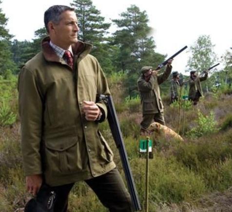
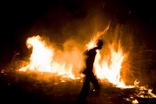

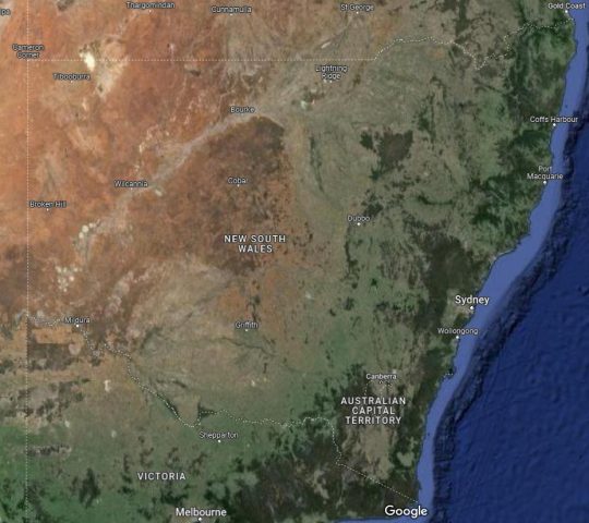
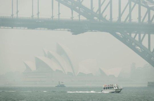

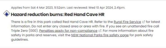

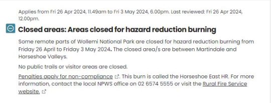
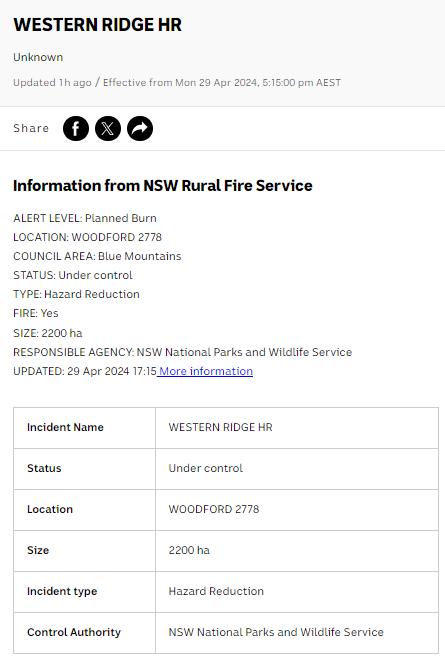


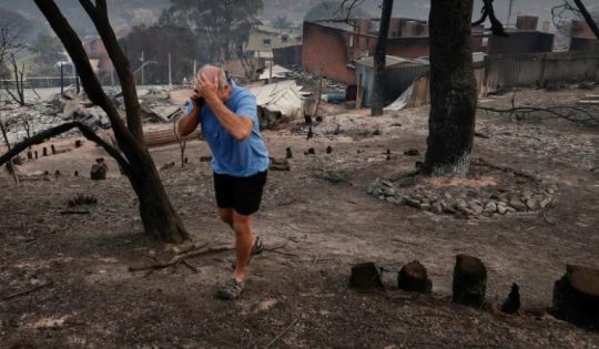

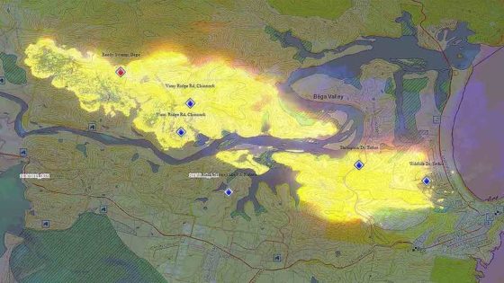
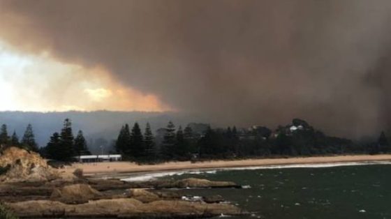

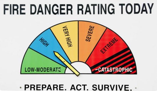
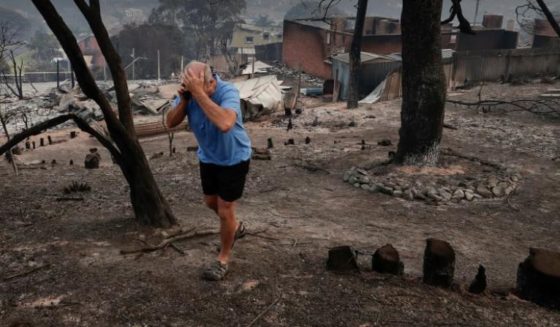
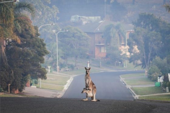

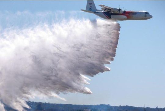

")


")

")


")


")
") Snow Gums do not enjoy being burned to death
Snow Gums do not enjoy being burned to death")

")
") Captain Michael D. Miller in 1968
[New life amongst so much death]
Captain Michael D. Miller in 1968
[New life amongst so much death]

")


")

")

")
")

")
")


")


")
")
")
")
")


")


