Posts Tagged ‘wildfire’

National Parks left to burn because not ‘assets’

Thursday, November 8th, 2012
Oxley Wild Rivers National Park
Click image to enlarge
Inscribed on the asset register of World Heritage sites in 1994…but how much has been wiped out by October’s bushfires?
[Photo Source:  New South Wales Government,
^http://www.nationalparks.nsw.gov.au/oxley-wild-rivers-national-park/travel-info]

.

Location of Oxley Wild Rivers National Park
Click image to enlarge – note the patchy dark green of  remnant forests
[Source:  Satellite Map – Google Maps]

.

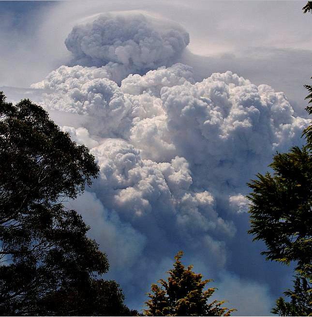
The ‘Macleay River’ Bushfire  (Oct 2012)

.

Macleay River Bushfire October 2012
– left to burn for a week from 12th Oct 2012 because not a threat to private property
..then the wind picked up…unbelievable!

.

Over the past month, a single contiguous area covering some 60,000 hectares of vegetation has been left to burn by bushfire.  That equates to 600 km2 or roughly 25km x 25km.

Much of what has been burned is/was of World Heritage values within the included Oxley Wild Rivers National Park.  This is unacceptable custodial neglect.

If this was Sydney, this is the black boxed area that would have been incinerated:Putting this 60,000ha bushfire into a Sydney urban perspective
Professional urban fire fighting would not allow 60,000 hectares of private property and human lives to burn
– such would historically dwarf the Great Fire of London.

.

The Rural Fire Service has labelled the bushfire the ‘Macleay River Fire‘.  But it began as two separate bushfires on or before 12 October, nearly a month prior.  One was then labelled ‘Georges Junction Fire‘ and the other ‘Freds Creek Fire‘, both purportedly ignited by bush arsonist(s).  Seven days later, the Georges Junction Fire has burnt an estimated 8,931 ha, while the then much smaller Freds Creek Fire had burnt 1,688 ha.  By the time the combined bushfire was extinguished 60,000 hectares had been burned, much within the World Heritage Area..

This is yet another classic case of bushfire neglect primarily by the delegated custodians of the National Park and World Heritage Area – the New South Wales National Parks and Wildlife Service.  Is this due to chronic lack of resourcing; and/or symptomatic of a disturbing rationalist culture that believes that burning Australian vegetation, even ancient rainforest, could be somehow beneficial to biodiversity.

Remote ignitions go undetected, then unsuppressed, until many days later, bushfire weather conditions worsen and the fires get out of control, combine and destroy vast areas of important Nationl Park and World Heritage. 

This 2012 Macleay River Fire is like the ‘2006 Grose Valley Fires‘ of the Blue Mountains repeated to script.

.

Read our article:   >‘2006 Grose Valley Fires – any lessons learnt?’

.

The Australian Government continues to be ultimately culpable for gross neglect in failing to protect its custodial listed natural heritage.

The Rural Fire Service has learnt to avoid accusatioins of incompetence by routinely removing timely records on its websites about the operational response in the days at the start of the ignitions.   Details about the timings of ignition detection and initial suppression are deliberately withheld from the public.

The following bushfire updates are mainly from second-hand news media.   A notable recurring theme across these news reports is that the media interest and the target of the fire fighting effort, just like in urban fire fighting, is to save humans lives and property. This is not a bad thing, but the glaring omission is the lack of interest in suppressing the bushfire in the National Park and World Heritage.

The Rural Fire Service policy and operational strategy is such that if human lives and properrty are not directly threatened by bushfire, then a bushfire is allowed to continue burning, irrespective of whether it is burning through National Park or World Heritage.  Since the Rural Fire Service has the same terms of reference as the professionaly paid New South Wales Fire Brigade, then they are essentially doing the same urban job.

The only reason the Rural Fire Service exists in less populated rural areas instead of the professionaly paid New South Wales Fire Brigade, is traditionally so that the Australian Government and New South Wales Government can save money by relying on unpaid, under-resourced volunteers.  Yet the environment in rural fire fighters work in is inherently more dangerous, demanding and in need of sophisticated resources for military-speed detection and suppressions of bushfires.

.

21 Oct:   Bushfire Update

.

‘Blazes burn out of control: Permits suspended as hot, dry weather hits North West’

[Source: ”Blazes burn out of control: Permits suspended as hot, dry weather hits North West”, by Wendy Spooner, Northern Leader (regional newspaper), 20121021, ^http://www.northerndailyleader.com.au/story/411057/blazes-burn-out-of-control-permits-suspended-as-hot-dry-weather-hits-north-west/]

.

Satellite infrared image of the fire called Georges Junction inside the Oxley Wild Rivers National Park
Having already burnt out a massive 14,000 hectares and is likely to join up with the Freds Creek fire.
The active edge of the fire shows up bright yellow; the red areas are the burnt areas.
(Photo by New England RFS)

.

<<Two massive bushfires in the Oxley Wild Rivers National Park were basically running unchecked yesterday because of adverse firefighting conditions, incident controller for the New England bushfire emergency, Allyn Purkiss, said.

Mr Purkiss said the two Section 44-declared fires one named Freds Creek and the other Georges Junction were likely to join up yesterday and burn out a total of 30,000 hectares in the coming weeks.

“They took a big run under strong winds (on Saturday)..The fires had started after landholder burns had got away”, Mr Purkiss said.

..The fire named Freds Creek, which started on October 12, had burnt out 3,189 hectares and was crowning at 4am yesterday, with flames jumping from treetop to treetop.

“It means it’s very uncontrollable very dangerous conditions,” Mr Purkiss said yesterday.

The RFS had been unable to aerial-bomb the fires because of gusty winds.  Mr Purkiss described it as “nigh-on impossible” to water-bomb in those conditions.
Instead, RFS volunteers had concentrated on saving property.   He said it was hard to tell how many homes and remote-area shacks might be affected.

“We’re still trying to come to terms with that. We could have up to 50 in the area: there are shacks all through this country,” he said.

Mr Purkiss said the other fire, Georges Junction, had already burnt out 14,000 hectares.   (Ed: Same as the 2006 Grose Valley Fires).

He said conditions in the New England RFS zone were “fairly similar” to strong, gusty winds on Saturday.  “The forecast is for 50km/h winds by late afternoon,” Mr Purkiss said.

No homes had been lost in either fire yet.  “None that we know of,” he said.  The RFS was doing a “fairly extensive reconnaissance of the area”, he said.

Three other fires one about 40km east of Guyra, one near Walcha and one near Ebor had also started since Friday.

The Guyra fire, which started on Saturday, was located in the Mt Mulligan/Wards Mistake area.

Locals had alerted the RFS to the fire, which was in “very remote country … it’s difficult to get to no roads, no trails”, Mr Purkiss said.

“I’ve tasked an aircraft to get out there today and map it and give us some intel (intelligence),” he said..

“No properties were under threat: it was burning in scrub.

.

Mr Purkiss said he was “not sure” how much land had been burnt out he would have to wait for information provided by the aircraft crew.

The Walcha fire, called Panhandle and in the Enfield State Forest, had burnt out five hectares by the time it was contained by mid-afternoon on Saturday.

The Ebor-area fire was located “in an area we can’t get to”, Mr Purkiss said.  “We’re flying to map it today,” he said yesterday.

It had also burnt out five hectares.

“Local landholders and Ebor RFS assisted in containing it,” he said.

Mr Purkiss said the New England RFS zone was unlikely to lift its suspension of fire permits today.

“While ever we have a bushfire emergency like this going, all permits are suspended we’re already dealing with enough fires, so we don’t need any more mistakes giving us grief than we already have,” he said.

Mr Purkiss said this season had already started to play out differently compared to the past three years.

In the past three fire seasons, rain had usually come along and helped extinguish any fires but this season was different, with many more periods of extended dry weather.

“In talking to the local staff, they say that this (Georges Junction) is the largest fire they have had since 2009,” Mr Purkiss said.  “We’re working hard to get it done.  We thank the volunteers and employers for allowing us to fight these very large fires.”>>

.

22 Oct:   Bushfire Update

.

‘Macleay River fire threatens homes’

[Source:  ‘Macleay River fire threatens homes’, by Victoria Nugent, The Armidale Express (regional newspaper), 20121022, ^http://www.armidaleexpress.com.au/story/410559/macleay-river-fire-threatens-homes/?cs=469]
.Properties between Georges Junction and Five Day Creek were at threat from fire yesterday
(Photo: The Armidale Express)

.

<<Fire continues to threaten properties near Oxley Wild Rivers National Park after two blazes combined yesterday.

The Macleay River bushfire had already burnt about 20,000 hectares early yesterday afternoon as more than 30 firefighters battled the out of control blaze, NSW Rural Fire Service spokeswoman Bridie O’Connor said.

The inferno may have posed a threat to properties between Georges Junction and Five Day Creek, particularly on the Carrai and Fitzroy Tablelands and on the Macleay River in the vicinity of Lower Creek and Comara, Ms O’Connor said early yesterday afternoon.

“We’re looking at a minimum of six hours before some properties might be affected,” she said.   “People should expect to see smoke and fire and be alert.”

Hot and windy conditions over the weekend (20th and 21st) saw the fires at Georges Junction and Freds Creek combine.

The Georges Junction fire, near Cochrane State Forest, which started on October  12 had burnt more than 14,859 hectares and was still burning out of control when it met with the Freds Creek fire early yesterday afternoon.  The fire at Freds Creek was being controlled yesterday afternoon after three State Forest groups joined the NSW Rural Fire Service to use bulldozers to create fire breaks earlier in the week.

Meanwhile, the Armidale to Kempsey Road between Waterfall Way and Bellbrook was closed on Saturday and Sunday because of the fires.
The Rural Fire Service was concentrating its efforts on establishing containment lines.

People on properties near Georges Junction and on the Macleay were urged to be alert for fire warnings.>>

.

23 Oct:   Bushfire Update 

.


‘Total fire bans expected back in place by Thursday’

[Source:  ‘Total fire bans expected back in place by Thursday’, by Campbell Walker, Namoi Valley Independent (newspaper), 20121023, ^http://www.nvi.com.au/story/415687/total-fire-bans-expected-back-in-place-by-thursday/]

.

<<…Adverse weather conditions on Sunday hindered attempts to subdue two massive bushfires in the Oxley Wild Rivers National Park. Fire crews were reduced to protecting property on the ground and the two fires merged late on Sunday as fire crews battled from the ground to protect property, unable to water bomb due to gusty winds across the region.

The fire, now named the Macleay River Fire had burnt out 28,733 hectares as of last night,   Inspector Brett Loughlin, public liaison officer for Armidale Section 44 with the NSW Rural Fire Service, said.

Mr Loughlin was expecting the fire to burn out more land.

“We’re doing some mapping now and expect it to be around that 30,000-hectare mark,” he said.   He said 52 firefighters were on the ground creating firebreaks, doing backburning and  helping protect the property of landholders living within a few kilometres of the fire front.

“There are properties in close proximity,” Mr Loughlin said.  “The fire has flared up a little this afternoon and some embers are falling around properties in the Lower Creek area.

“No property is under threat at the moment … the fire’s not doing anything like it was doing on Saturday (when it was out of control – a day of hot, gusty westerly winds).”

Five helicopters are currently tasked to water bombing the Macleay River Fire.

Oxley Wild Rivers National Park is still shut to the public…>>

.

.

25 Oct:  Bushfire Update

.

‘Arson suspected in Macleay River fire

[Source:  ‘Arson suspected in Macleay River fire’, by Kitty Hill, Northern Daily Leader (local print newspaper), 20121025, ^http://www.northerndailyleader.com.au/story/420443/arson-suspected-in-macleay-river-fire/]

.

<<Rural Fire Service forensic investigators have interviewed a ‘person of interest’ as the battle to contain the Macleay River fire enters its 15th day.

RFS investigators from Kempsey and Coffs Harbour arrived yesterday to investigate the possible cause of the blaze in the Oxley Wild Rivers National Park which has since burnt out 33,160 hectares of bush and pasture land.

RFS Public Liason Officer Inspector Brett Loughlin said all major fires were investigated as a matter of cause and investigations were ongoing.

Around 80 firefighters from the NSW RFS, FRNSW and NPWS, supported by five aircraft and four bulldozers are fighting the fire, which has a 247 kilometre perimeter.

Ember attack on properties around the Lower Creek area were reported yesterday but Inspector Loughlin said that firefighters were working with local landholders to protect at-risk homes.

Inspector Loughlin said that good containment lines had been established by fire crews in the last 24 hours and today “aerial incendiary” work  by helicopter would be carried out on the south western side of the blaze.  “It’s still an active fire but we’re starting to get a handle on it,” Inspector Loughlin said.

The Macleay River Fire is the culmination of the ‘Freds Creek Bushfire‘ and ‘Georges Junction Bushfire‘ that had merged last weekend.  The fire is burning in the vicinity of the Comara, Georges Junction, Five Day Creek, Lower Creek, Blanches Creek and Smith Creek areas.

Another fire burning near Guyra, has been contained. The ‘Mulligans Bushfire‘, which has burnt out 3207 hectares near the Guy Fawkes National Park has been burning since Saturday.>>

Macleay River Bushfire
(Photo by Sean Bremmer)

.

1 Nov:  Bushfire Update

.

Rural Fire Service Reported Operational Statistics:

[Source:  New South Wales Government,  Rural Fire Service, ^http://www.rfs.nsw.gov.au/]

MACLEAY RIVER FIRE
ALERT LEVEL:  Advice
LOCATION:  50 kms east of Armidale, 75 kms west of Kempsey, 65kms east of Walcha
COUNCIL AREA:  Armidale Dumaresq
STATUS:  Being Controlled   (Ed:  glass half-full spin)
TYPE:  Bush fire
FIRE:  Yes
SIZE:  51,405 ha
RESPONSIBLE AGENCY:   Rural Fire Service
UPDATED:   1 Nov 2012 15:25

.

5 Nov:  Bushfire Update

.

‘NSW fires declared natural disaster zones’

.

[Source:  ‘NSW fires declared natural disaster zones’, by AAP, 20121105, ^http://www.heraldsun.com.au/news/breaking-news/nsw-fires-declared-natural-disaster-zones/story-e6frf7kf-1226510654741]

.

<<Three local government areas have been declared natural disaster zones in the wake of a major fire that has been raging in northern NSW for two weeks.

The massive front formed on October 21 when the Freds Creek and Georges Junction fires combined at the Macleay River.  It has damaged over 51,000 hectares of:

  • National Parks
  • State Forests
  • Private Land

.

across three shires:

  1. Armidale Dumaresq shire
  2. Walcha shire
  3. Kempsey shire

.

“These fires have been burning in the area for a number of days and due to the conditions, they merged into one large fire, jumped containment lines and threatened numerous properties,” Emergency Services Minister Michael Gallacher said in a statement on Monday.

“This declaration triggers a number of disaster assistance schemes to assist with the cost of disaster relief and recovery.”

Over the last two weeks, bushfires have raged across the New England and Mid North Coast regions.  Other fires under this declaration include the Clay fire in Armidale Dumaresq, the Panhandle fire in Walcha and the Mulligans fire in Guyra on the western side of Guy Fawkes National Park, which has burnt over 3,400 hectares of National Park and private land.

Mr Gallacher said the Macleay River fire had damaged significant portions of the Oxley Wild Rivers National Park, which is part of the Gondwana Rainforests of Australia World Heritage Area, a series of protected areas which were first inscribed on the World Heritage List in 1986 and extended in 1994.


.

5 Nov:  Bushfire Update

.

<<Three separate fires burning out of control south-west of Casino since the weekend have been contained, the Clarence Valley Rural Fire District reports.

The ‘Dubadar Creek Bushfire‘, which was believed to have been started by arsonists before blowing out from 50ha to 300ha on Saturday, was contained on Sunday and was extinguished at midday today, the district’s incident controller Stuart Watts said.

Two separate blazes, also deliberately lit, at Mt Pickabooba 4km from the Dubadar Creek fire were expected to be contained by this afternoon following back-burning, Mr Watts said. The Rural Fire Service had 10 fire trucks, 19 personnel and two bulldozers working to bring the fires under control on the weekend.  The Northern Star has approached the police for comment.

The battle with the blazes come as NSW Police and Emergency Services Minister Michael Gallacher declared natural disasters for the Mid North Coast – parts of which only a year ago were receiving the same declaration for floods – and New England areas.

“The main focus of this declaration is the Macleay River Fire, which developed on 21 October 2012 as the culmination of the Fred’s Creek and Georges Junction Fires,” Mr Gallacher said in a written statement.

“These fires have been burning in the area for a number of days and due to the conditions, they merged into one large fire, jumped containment lines and threatened numerous properties…Firefighters have been working hard to create containment lines around the Macleay River Fire to protect properties as the fire approaches.

“As of 1 November 2012, the Macleay River Fire continues to burn and is estimated to have damaged over 51,000 hectares of National Parks, State Forests and private land across the three LGA’s of Armidale Dumaresq, Walcha and Kempsey.

“The Macleay River Fire has damaged significant portions of the Oxley Wild Rivers National Park, which is part of the Gondwana Rainforests of Australia World Heritage Area, a series of protected areas which were first inscribed on the World Heritage List in 1986 and extended in 1994.“>>

.

Reader Comment:

by  ‘coco50’ from Ballina 20111105:

<<When is our judicial system going to get serious about arsonists? It is difficult enough to catch them. Think about what they do. They destroy natural bushland and animal habitat. They put the lives of people at risk or even cause deaths. They destroy property which causes hardship and suffering and years to rebuild. This pushes up everyone’s insurance premiums. They out emergency services personnel at risk.

But when we get an arsonist in court, the defence counsel makes an argument like: “My client had a difficult childhood – his parents and peers didn’t understand him. He is remorseful”

The Judge almost cries while handing out a “slap on the wrist” sentence. It is much harder to start a fire in jail while you are doing 20 years time. Lock them up!>>

.

[Source:  ‘Fires contained as disaster declared’ , 20121105, Northern Star (local print newspaper), ^http://www.northernstar.com.au/news/fires-contained/1609219/]

.

6 Nov: Bushfire Update

.

Rural Fire Service Reported Operational Statistics:

.

[Source:  New South Wales Government,  Rural Fire Service, ^http://www.rfs.nsw.gov.au/]

.

‘MACLEAY RIVER BUSHFIRE’
ALERT LEVEL:  Advice
LOCATION:   65km East of Walcha
COUNCIL AREA:  Armidale Dumaresq
STATUS:  Being Controlled
TYPE:  Bush fire
FIRE:  Yes
SIZE:  59, 663 ha
RESPONSIBLE AGENCY:  Rural Fire Service
UPDATED:   6 Nov 2012 09:10

.

Oxley Wild Rivers National Park is World Heritage ‘protected

.

1986:   Gondwana Rainforests of Australia inscribed on the World Heritage List.

.

World Heritage Listing because local people thought it was so important to save before it was gone

.

Over twenty-five years ago, in 1986 the Gondwana Rainforests of Australia, then called the Central Eastern Rainforest Reserves of Australia (CERRA), were inscribed on the World Heritage List for their outstanding natural universal values.

Theses rainforest comprise the Great Escarpment of eastern New South Wales, then known as the Australian East Coast Sub-tropical and Temperate Rainforest Parks, were inscribed on the World Heritage list meeting the following three World Heritage Natural Criteria:

  • Outstanding example representing significant ongoing geological processes and biological evolution   (World Heritage Natural Criterion viii)
  • Outstanding example representing major stages of the earth’s evolutionary history   (World Heritage Natural Criterion ix)
  • Containing important and significant habitats for the in situ conservation of biological diversity      (World Heritage Natural Criterion x)

.

Trying to save the surviving remnant patches of Gondwana Rainforest ecosystems
(Ed:  These few green shades are emblematic of Australian ransacking)
Read:  >Large Map
[Source: ^http://www.environment.gov.au/heritage/places/world/gondwana/pubs/gondwana-map.pdf]

.

The Gondwana Rainforests contains the largest and most significant remaining stands of subtropical rainforest and Antarctic Beech (Nothofagus moorei) cool temperate rainforests in the world, the largest and most significant areas of warm temperate rainforest and one of only two remaining large areas of Araucarian rainforest in Australia.


Enormous Antarctic Beech  (Nothofagus moorei)
At Cobark Park, Barrington Tops, 50 metres tall

.

The Gondwana Rainforests of Australia is a serial property comprising the major remaining areas of rainforest in southeast Queensland and northeast New South Wales.  They include the most extensive areas of subtropical rainforest in the world, large areas of warm temperate rainforest and nearly all of the Antarctic beech cool temperate rainforest. Some of the oldest elements of the world’s ferns and conifers are found here and there is a concentration of primitive plant families that are direct links with the birth and spread of flowering plants over 100 million years ago.

A wide range of plant and animal lineages and communities with ancient origins in Gondwana, many of which are restricted largely or entirely to the Gondwana Rainforests, survive in this collection of reserves. The Gondwana Rainforests also provides the principal habitat for many threatened species of plants and animals.

The area is one of the best places on earth to see ancient ferns and Araucaria such as Hoop Pines.


Hoop Pine
(Araucaria cunninghamii)
Found naturally in the dry rainforests of New South Wales and Queensland and in Papua New Guinea.
The trees can live up to 450 years and grow to a height of 60 m.

.

Rainforest once covered most of the ancient southern supercontinent Gondwana and remains the most ancient type of vegetation in Australia. The Gondwana Rainforests provide an interesting living link with the evolution of Australia. Few places on earth contain so many plants and animals which remain relatively unchanged from their ancestors in the fossil record.

Due to two centuries of colonial deforestation across New South Wales and Queensland – timbergetting, ‘land clearing’ for agriculture and housing – the reserves of rainforest that comprise The Gondwana Rainforests in discontinuous patches, surrounded by fireprone eucalypt forest and cleared agricultural lands.

These patches range in size from tiny gully stands to lush forests covering large valleys and ranges.    Collectively, these ‘serial sites’  despite their small size and scattered fragments, provide proximity and interconnection by corridors of semi-natural habitats and buffers.   Their natural asset value is fragile and demands intensive management and protection in order to preserve their ecological integrity.

.

Read:   >Gondwana Rainforests of Australia Fact Sheet   (4 pages, PDF, 1.4 MB)

[Source:  Australian Government, ^http://www.environment.gov.au/heritage/places/world/gondwana/resources.html]

.

The ecosystems of the Gondwana Rainforests contain significant and important natural habitats for species of conservation significance  (World Heritage Natural Criterion x).

The Gondwana Rainforests provides the principal habitat for many species of plants and animals of outstanding universal value, including more than 270 threatened species as well as relict and primitive taxa. Many of the rare and threatened flora and fauna species are rainforest specialists, and their vulnerability to extinction is due to a variety of factors including the rarity of their rainforest habitat.

The Gondwana Rainforests also protects large areas of other vegetation including a diverse range of heaths, rocky outcrop communities, forests and woodlands. These communities have a high diversity of plants and animals that add greatly to the value of the Gondwana Rainforests as habitat for rare, threatened and endemic species. The complex dynamics between rainforests and tall open forest particularly demonstrates the close evolutionary and ecological links between these communities.

Species continue to be discovered in the property including the re-discovery of two mammal species previously thought to have been extinct:

  1. The Hastings River Mouse (Pseudomys oralis)
  2. Parma Wallaby (Macropus parma)


Parma Wallaby (Macropus parma)
Endemic to rainforests and sclerophyll forests in New South Wales from the Watagan Mountains in the South to the Gibraltar Range in the North.
Parma wallabies were thought to have become extinct a century ago until being discovered again in the 1970s.

.

1994:   Oxley Wild Rivers NP added to World Heritage

.

In 1994, large extensions of rainforests across south-east Queensland and New South Wales including  the Oxley Wild Rivers National Park were added to the World Heritage listed Central Eastern Rainforest Reserves of Australia (CERRA), now entitled The Gondwana Rainforests of Australia (since 2007).

OxleyWild Rivers National Park – location map
[Source:  Google Maps]
.

These reserves comprise almost 50 separate remnant reserves of unspoilt rainforest wilderness stretching from north-east New South Wales (the Oxley Rivers region) up through south-east Queensland. Each of these reserves contains important nature conservation values in its own right, however the full significance of the property becomes evident only when viewed as a whole, and collectively CERRA provides a significant network of habitats for many of Australia’s rare and endangered species.

Since 1994, the Australian Government in co-operation with both the New South Wales and Queensland Governments have recognised the need for coordinated, consistent and cooperative management, to ensure that the integrity of CERRA‘s values is protected.  At the time, the World Heritage Committee requested the Australian Government complete management plans of individual sites.  Six years later in 2000, the Australian Government published its ‘Strategic Overview for Management for the Central Eastern Rainforest Reserves of Australia to guide co-operative management by the three Governments in relation to the identification, protection, conservation, rehabilitation and presentation of the Gondwana Rainforests.   In 2002, a Technical and Scientific Advisory Committee and a Community Advisory Committee were established.

The Gondwana Rainforests of Australia are managed principally by the New South Wales National Parks and Wildlife Service (part of the New South Wales Department of Environment and Climate Change) and the Queensland Environmental Protection Agency.

.

Read:   >’Strategic Overview for Management‘  (59 pages, PDF, 1.1 MB)

[Source:  Central Eastern Rainforest Reserves of Australia – Strategic Overview for Management’, November 2000, Australian Government, ^http://www.environment.gov.au/heritage/publications/strategy/pubs/mgtoverview.pdf]

.

Later 1,850 ha of Winterbourne State Forest, also known at the Big Lease, was added to the reserves wilderness.  Currently (2012), the remaining 1,560 ha of Winterbourne and 1,075 ha of Enmore State Forests are to be added to the National Park. Further inclusions include Green Gully headwaters and 1,439 ha of leasehold land in the lower Chandlers River gorge.

The Macleay Gorges Wilderness Area, covering 50,000 hectares, was declared World Heritage in 1996 and further extended in 1997.

In 2007,  Macleay Gorges Wilderness Area and Oxley Wild Rivers National Park, along with the 50 separate Crown Land reserves of remnant ancient rainforest were collectively renamed under the umbrella term Gondwana Rainforests of Australia to better reflect their World Heritage values.   These include important rainforested areas between Newcastle and Brisbane from Mount Royal National Park and Banrrington Tops National Park to Lamington National Park inland of Queensland’s Gold Coast.

.

Read:  > Oxley Wild Rivers National Park – key threats and impacts  (PDF, 170kb)

[Source:  Australian Government, ^http://www.environment.gov.au/biodiversity/invasive/publications/pubs/mainland-islands-oxley-wild-rivers-national-park.pdf]

.

Aspley Falls in flood
Oxley Wild Rivers National Park

.

High waterfalls crashing into steep gorges are spectacular examples of an important ongoing natural process – erosion. Erosion by coastal rivers created the Great Escarpment and the steep-sided caldera of the Tweed Valley surrounding Mount Warning. This towering mountain was once the buried plug of an ancient vast volcano. Today, rainforest grows on the fertile, well watered soils that remain.

The Macleay River on the Mid North Coast of New South Wales, Australia, has the world’s second-fastest flowing currents during flooding, when it can hold over 200,000 gigalitres.

Its headwaters flows from the Gara River on the eastern side of the Northern Tablelands near the tonwships of Armidale and Walcha.  Key tributaries are the Chandler River, Styx River and Apsley River as well as the Tia River, Dyke River and Yarrowitch River, which pass through a number of spectacular gorges and waterfalls in the Oxley Wild Rivers National Park.

The Macleay River flows 400km south-east through Kempsey and into the Pacific Ocean at South West Rocks.   Upon colonial discovery in the 1820s; the ancient, tall native Red Cedar (Toona ciliata) forests were completely deforested.

Australian Red Cedar Forest
Tamborine National Park, Gold Coast Hinterland, Queensland
(such trees have long been logged through the Oxley Rivers region)

.

In 1976, the Apsley Macleay Gorges were identified as being of ‘true wilderness quality‘.

At that stage the public protection offered to the area was limited to two small reserves in the south, and a few local council run recreation areas at popular sites such as Wollomombi Falls, Dangars and Apsley Falls. With future land-use undecided, the NSW Electricity Commission began surveying the Apsley Valley for a hydro-electric scheme in the late 1970s. The Apsley Gorge National Park of 6,718 hectares was gazetted followed by the 3,456 hectare Yarrowitch Gorge National Park soon after.

In 1989 East Kunderang Station of 30,400 hectares passed to the National Parks and Wildlife Service (NPWS) and was proclaimed the Oxley Wild Rivers National Park.

.

Rich Wildlife through Oxley Wild Rivers National Park

.

Oxley Wild Rivers National Park is rich in fauna, with over 350 species recorded, including 55 mammals.

It is a major refuge for the Brush-tailed Rock-wallaby (Petrogale pencillata), with the largest confirmed population in the Green Gully area of Yarrowitch.

.

Brush-tailed Rock Wallaby (Petrogale penicillata) in Oxley Wild Rivers National Park
This species is listed in New South Wales as ‘Vulnerable to extinction’, but that was by the NSW Scientific Committee in 2003, nine years ago
There have been two major bushfires through since then – one in 2009 and now in 2012
How many viable individuals have been lost to the Macleay River Bushfire – does the NSW NPWS know or care?

.

<<Oxley Wild Rivers National Park, including Green Gully Track, is closed until further notice due to wildfire.>>

[Source:  ^http://www.environment.nsw.gov.au/NationalParks/parkFireClosure.aspx?id=N0043]

.

Other species found in the park include:

  • Dingoes
  • Bandicoots
  • Bats
  • Koalas
  • Wombats
  • Quolls
  • Brushtail Possums
  • Sugar gliders
  • Platypus
  • Echidnas
  • Numerous small ground mammals
  • Wedge-tailed Eagles
  • Peregrine falcons


Over 173 bird species, 38 reptile and 19 amphibian species have been recorded in Oxley Wild Rivers National Park.

Skinks, goannas, tortoises, lizards, snakes, frogs and fish occur in the park, particularly on the river flats. A number of fish species have been recorded. Notable, is the speckled longfin eel (Anguilla reinhardtii), which breeds in the ocean with the juveniles eventually returning to the Apsley–Macleay River system.

There are fourteen known threatened species within the Oxley Wild Rivers National Park:

Six mammal species:

  1. Brush-tailed Phascogale (tuan)   (Phascogale tapoatafa)
  2. Brush-tailed Rock Wallaby (Petrogale penicillata)
  3. Koala  (Phascolarctos cinereus)
  4. Squirrel Glider (Petaurus norfolcensis)
  5. Tiger Quoll   (Dasyurus maculatus)
  6. Hastings River Mouse  (Pseudomys oralis)

.

Four bird species:

  1. Glossy Black Cockatoo  (Calyptorhynchus lathami)
  2. Greater Sooty Owl  (Tyto tenebricosa)
  3. Superb Fruit-dove  (Ptilinopus superbus),
  4. Turquoise Parrot  (Neophema pulchella)


One amphibian subspecies:

  1. Macleay River Turtle   (Emydura macquarii dharra)

.

One reptile species:

  1. Carpet Python  (Morelia spilota variegata)

.

Two frog species:

  1. Peppered Tree Frog (Litoria piperata)
  2. The Glandular Frog or New England Tree Frog  (Litoria subglandulosa)

.

Brush-tailed Phascogale
[Source:  Animal Hospital, ^http://www.chidlowmarsupialhospital.org.au/page-17-1-identification.html]

.

All these wildlife were previously widespread, but now are vulnerable to extinction or worse; which has become an Australian cliché, but at the same time an indictment on Australians.

But how much of this protected wilderness region is left after last fortnight’s bushfire catastrophe?

How can it be deemed to be protected, when bushfire is allowed to ravage it and its vitally recognised flora and fauna?   Was the World Heritage Area allowed to burn as a convenient bushfire management operational defacto Hazard Reduction?    There were no human assets at risk.  It was wilderness and so out of sight out of mind…such is the dominant bushphobic culture of the Australian and State Governments, so accused of neglect and incompetence after the 2009 Victorian Bushfires that killed 173 people.

To current anthropocentric (20th C babyboomer) governments, this ‘Macleay River Fire’,  irrespective of its World Heritage ecological protection, is blanketly and culturally dismissed as just another hazardous fuel region to target within Australia’s continent-wide Government Arson strategy.  Successive generations will revisit this prevailing cultural mindset of ‘hazard reduction‘ and cast it alongside 19th C ‘timbergetting‘ and 20th C ‘clearfelling‘.

In the Blue Mountains, some 40,000 hectares of native vegetation is currently approved by the same Australian and New South Wales Governments for deliberate burning.

If deliberately setting fire to the native vegetation is committed privately it is deemed bush arson and so attracts a poultry 14 years gaol or less even less, despite people having been burned to death as a direct consequence.

But if deliberately setting fire to the native vegetation is previously prescribed by Government, then participants are artificially deemed legally immune and impune from criminal liability, even if the prescribed bushfires they light get out of control, which is all too frequently.

The Australian Government’s official public relations message reads:

Institutional arrangements for the protection and management of Gondwana Rainforests are strong. The property is made up of 41 reserves, almost all of which are within the protected area estate, and primarily managed by the Queensland Parks and Wildlife Service and the New South Wales National Parks and Wildlife Service. Both States have legislation relating to protected areas and native flora and fauna that provide protection for the values of the Gondwana Rainforests.

All World Heritage properties in Australia are ‘matters of national environmental significance’ protected and managed under national legislation, the Environment Protection and Biodiversity Conservation Act 1999. This Act is the statutory instrument for implementing Australia’s obligations under a number of multilateral environmental agreements including the World Heritage Convention. By law, any action that has, will have or is likely to have a significant impact on the World Heritage values of a World Heritage property must be referred to the responsible Minister for consideration. Substantial penalties apply for taking such an action without approval. Once a heritage place is listed, the Act provides for the preparation of management plans which set out the significant heritage aspects of the place and how the values of the site will be managed.

National Heritage is also a matter of national environmental significance under the EPBC Act.

Importantly, this Act also aims to protect matters of national environmental significance, such as World Heritage properties, from impacts even if they originate outside the property or if the values of the property are mobile (as in fauna). It thus forms an additional layer of protection designed to protect values of World Heritage properties from external impacts.

The impacts of climate change and high levels of visitation, undertaking effective fire management, and mitigating the effects of invasion by pest species and pathogens present the greatest challenges for the protection and management of Gondwana Rainforests.

Climate change will impact particularly on those relict species in restricted habitats at higher altitudes, where particular microclimatic conditions have enabled these species to survive.

Management responses include improving the resilience of the property by addressing other threats such as inappropriate fire regimes and invasion by pest species, and trying to increase habitat connectivity across the landscape.

[Source:  Australian Government, ^http://www.environment.gov.au/heritage/places/world/gondwana/values.html]

.

Recall 2009:   9,500 hectares of Oxley Wild Rivers left to burn

.

In December 2009, a lightning strike started a bushfire in the Youdales Hut area of the Oxley Wild Rivers region.  The hut was unaffected (human property?), but 1,500 hectares of inaccessible steep country was burnt out before it was brought under control.

Another lightning strike started a large bushfire in the Reedy Creek region of the park. This fire has burnt out over 8,000 hectares of rough country.

.

[Ed:  Yes, steep wilderness terrain without convenient fire trails carved through it, is naturally inaccessible to lumbering urban fire trucks – so RFS/NPWS where were the waterbombing aircraft on 12th Oct 2012, when the fires were tiny and manageable?]

.

Blue Mountains copping ‘government-arson’

Saturday, May 21st, 2011

Wildlife Service sets fires to another 3000ha of World Heritage bushland

.

Last Wednesday (18th May 2011) right across the Blue Mountains, thick smoke choked the sky in a eye watering haze.  By Friday, an artificial red sunset was blazing through the wood smoke at the end of two days of New South Wales government-sponsored bush arson.

I knew exactly the ecological disaster unfolding, out of sight out of mind.

In its annual misguided winter ritual, the National Parks and Wildlife Service (Wildlife Service), aided and abetted by the Rural Fire Service has deliberately setting fire to remote bushland across The Blue Mountains World Heritage Area – a ‘natural planet asset’ of which the Wildlife Service is international custodian.

.

Linden Ridge HR Ops  (May 2011)

.

On Wednesday afternoon 18th May 2011, the aerial incendiary bombing commenced at Linden Ridge and extended down to the Grose River inside the Blue Mountains National Park (within designated wilderness within the World Heritage Area).  Bushfire management euphemistically call it ‘hazard reduction‘ (HR) ; rejecting any notion that bushland habitat is a natural asset, and instead demonising it as a ‘hazard’.

.

Massif Ridge HR Ops (May 2010)

.

The Linden Ridge ‘ops’ follows an almost identical HR ‘ops’  conducted the same time last year on 12 May 2010 in which aerial incendiary ‘ops’ commenced around Massif Ridge some 12 kilometres south of the town of Woodford in wild inaccessible forested area of the World Heritage Area.   Some 2500 hectares of high conservation habitat bushland in a protected wilderness area called the ‘Blue Labyrinth’ was indiscriminately incinerated – ridgetops, gullies, everything.  Refer to previous article on this website: >’National Parks burning biodiversity‘.

The same Blue Mountains National Park has been targeted by the same aerial incendiary bombing by the same Wildlife Service.  Both the operations were carried out under the orders of the Blue Mountains regional manager, Geoff Luscombe.

This is reducing the ‘hazard’
Click photo to enlarge, then click again to enlarge again and look for anything living.
After a year look for the animals.
After two years look for the animals….

.

.

.

Gross Valley Defacto HR Ops (Nov 2006)

.

Both the above HR Ops follow the massive conflagration of November 2006, infamously recalled across the Blue Mountains community as ‘The Grose Fire‘.  Two abandoned lightning strikes coupled with HR Ops along the Hartley Vale Road and escaping backburns coalesced and incinerated an estimated 14,070 hectares of the Grose Valley and adjoining ridge lands, much of which is designated wilderness.   Many consider the actions of the bushfire management response in hindsight to have been a defacto hazard reduction burn.  With such an effective elimination of the natural ‘hazard’ that year, as well as the public outrage, HR Ops went quite for four years.

How many animals native to this beautiful Grose Valley suffered an horrific burning death?
How many of their kind have now perished forever from the Grose?
…ask your Wildlife Service at Blackheath!
Charles Darwin in 1836 counted platypus in the area.
.

The perverted rationalisation by bushfire lighting theorists who have infiltrated the Wildlife Service is that the natural bushland, forests and swamps of  the Blue Mountains World Heritage Area are perceived not as a valuable natural asset, but as a world ‘hazard’ area to be feared and ‘to be burned in case they burn‘.

These same bushfire lighting theorists have effectively infiltrated, appeased and silenced local conservation groups such as the otherwise very vocal Blue Mountains Conservation Society, the National Parks Association of New South Wales and the umbrella conservation group the New South Wales Conservation Council.

The local conservation movement’s complicity to sanction explicit broadscale ecological harm is a disgraceful and ignoble abandonment of cherished core values, and a breach of duty to faithful environmental membership.

.

.


.

Broadscale indiscriminate ‘HR’ is no different to wildfire or bush arson

The Linden Ridge and Massif Ridge HR Ops were approved and executed by government in the name of ‘hazard reduction’ – to reduce the available ‘fuel’ (native vegetation) for potential future wildfires or bush arson.  In both cases, the massive broadscale natural areas burnt were not careful mosaic low intensity burning around houses.  This was broadscale indiscriminate fire bombing of remote natural bushland many miles from human settlement.   How can the deliberate setting alight of bushland where no fire exists, where no human settlement requires protection from the risk of wildfire be construed but anything other than government-sanctioned bush-arson?


.

The ‘Ecological Burn’ Myth

.

When bushfire management can contrive no other excuse for setting fire to native vegetation, such as when that vegetation is many miles away from human settlement and so poses no direct threat, out comes the concocted theory of the ‘ecological burn’.    The ‘ecological burn’ theory starts with the premise that because humans have observed that the Australian bush ‘grows back’ (eventually) after a bushfire, it may be concluded that the Australian bush can tolerate bushfires.  This hypothesis relies on evidence that selected species of Australian germinate after smoke and fire and the example of epicormic growth of many Eucalypts after fire.

The first deductive fallacy of this theory is that all the Australian bush is bushfire tolerant.    This deduction is then extended by unsupported assumption that since the Australian bush is bushfire-tolerant, bushfire must be an integral natural process to which the Australian bush has become adapted to bushfire.   The assumption is then extrapolated to assert that bushfire is indeed beneficial to the Australian bush.  The assumption is then stretched even further to conclude that without bushfire the Australian bush will be adversely affected.    The ecological burn theory then prescribes that by burning the Australian bush, whether by natural or unnatural means, the biodiversity of the Australian bush will be improved.

The deductive fallacy goes further, to suit the motives of the fire-lighters.   The outrageous generalisation is made that all the Australian bush must be burnt at some stage for its own ecological benefit.    ‘So go forth and burn it.  The bush will grow back.  It will do it good.’

.

The perverted irrational logic that Australia’s native vegetation has adapted to recover from fire, is akin to claiming the human body is adapted to recover from injury such as burns.  A wound may heal but no-one seeks to be injured in the first place.   And not all wounds heal.  A third degree burn to more than 50% of a human body is almost a certain death sentence.   What percentage of a wild animal’s body can be burnt and the animal still survive? That’s a perverted question for the fire-lighters.

Broadscale hazard reduction is not mosaic patch-work fire.  It is not creating a small scale asset protection zone around the immediate boundary of a human settlement.  It is wholesale bush arson that is driving local extinctions.  Ever wonder why when bushwalking through the Australian bush so few native animals are seen these days?   Their natural populations have been decimated through two centuries of human harm – mainly poaching,  introduced predation and habitat destruction including by human-caused bushfires and human-abandoned bushfires.

The recent concept of the so-called ‘ecological burn’ is a contrivance, a myth.  It is a false cause fallacy.  Ecological fire a defunct scientific theory contrived by bushfire management engaging unemployed graduates to think up an idea for a PhD.  It belongs in the same discarded bucket of defunct scientific theories from days of yore of such ilk as ‘alchemy‘, ‘phlogiston‘, ‘flat earth‘, ‘hollow earth‘ and ‘the birth cries of atoms’ theories. Yup, these were once believed. 

[Source: http://www.shortopedia.com/O/B/Obsolete_scientific_theories].

.

The effect on wildlife habitat by broadscale ‘hazard’ reduction is no different than if it was caused by wildfire or bush arson.  The hazard to wildlife habitat is the same.  The broadscale blanketing of bushland with high intensity burns that reach into the tree tops and scorching ground cover and earth, present the same intense fire regime.  The landscape is laid to waste in just the same way as wildfire or bush arson does.  Habitat and the wildlife it accommodates become the innocent victims of horrific bushfire, no matter how caused.

There is no wildlife monitoring before, during or after one of these aerial incendiary ‘ops’.   Aerial incendiary guarantees no discretion between fire sensitive habitat and fire-resilient habitat.  It is a simplistic, convenient a cheap one-size-fits-all solution that re-colours the fire maps to appease political masters. The chopper boys are given their bombing co-ordinates and then do their search and destroy mission.  These airborne lads should apply their skills to good and not evil.   They should stick to improving their water bombing skills, not participating in this perverted fire-lighting culture.

When the rains follow, the thin yet vital topsoils get washed away into the gullies and streams.  This erodes the landscape and prevents regrowth of many flora species due to the lack of vital nutrients.  After both the Massif Ridge HR and the Linden Ridge HR, heavy rains did follow.

Only the species of flora adapted to bushfire recover.  Fire sensitive species of flora are eliminated from the landscape.  Name one species of fauna that is fire tolerant.  Where are the zoologists in the Wildlife Service to tell of the impact of the HR?  If this mob is providing a ‘service’, it certainly ain’t providing a service to wildlife.

.

.


.

Wildlife Service chief boasts of mass incineration of 92,000 ha of National Parks

.

And the Wildlife Service regional chief for the Blue Mountains region, Geoff Luscombe, in his media release 17th May 2011 boasted of his:

3000 hectare burn” that “the NPWS carried out more than 92,000 hectares of hazard reduction in 269 burns in 2009/10 – its biggest ever program.”

.

To put this area into perspective,  in terms of the Blue Mountains World Heritage Area of about 1 million hectares, such a hazard reduction programme over a decade would decimate the Blue Mountains completely.  And they call themselves a ‘Wildlife Service’?

Once again thousands of hectares of pristine flora and fauna habitat in deep inaccessible terrain, miles from houses and human property, has been incinerated from the air using contracted aircraft dropping indiscriminate aerial incendiaries.  If only these boys had napalm!

Luscombe confirms in his media release…

An aircraft will be used to manage the burn as most of the burn will take part in remote areas of the Blue Mountains.”

.

This incineration of natural wildlife habitat is justified by the Wildlife Service as ‘strategic‘ and ‘hazard reduction‘ operations are one of many being conducted by NPWS around the state making the most of the dry sunny winter conditions.  This burn is part of the NPWS annual fire management program.

Luscombe again:

…“reducing the volume of fuels within strategic areas of the Park, can assist in limiting the intensity and rate of spread of a wildfire in the area.”

.

Then on Friday 20th May 2011, vertical plumes of smoke were seen rising from Cedar Valley south of the Jamison Valley ~ another one of these secret HR aerial incendiary black ops that the public is not supposed to know about?  No notice on either the Blue Mountains Rural Fire Service site or the Wildlife Service site. Out of sight, out of mind.

.


.

.

‘Strategic Fire Management Zones’ – a symptom of a bushphobic cult out of control

.

Under the Blue Mountains Bushfire Management Committee which governs the Blue Mountains region, ‘environmental assets’ are restricted to “threatened species, populations and ecological communities and Ramsar wetlands, locally important species and ecological communities, such as species and ecological communities especially sensitive to fire.”

So how does aerial incendiary discriminate when setting fire to a contiguous 2500 hectares or 3000 hectares of wilderness?

Answer: It doesn’t , it doesn’t seek to, it doesn’t care.  The guidelines are only to keep the greenies happy.  It’s called ‘greenwashing’.

The Wildlife Service in its official Fire Management Strategy, has relegated 97.7% of the Blue Mountains National Park into either what it calls ‘Strategic Fire Advantage Zones’ or else ‘Heritage Zones.   In essence, heritage Zones are valued natural areas that are protected from fire, whereas the Strategic Fire Advantage Zones are expendable.  The Wildlife Service proclaims that …due to the ‘relative lack of practical fire control advantages’  (lack of access and resources),  Strategic Fire Management Zones are ‘managed’ to protect community assets… to reduce fire intensity… assist in the strategic control… to contain bush fires and to strengthen existing fire control advantages.

All of which simply means is that it is expendable and can and should be burnt in case it burns.  Strategic Fire Management Zones ‘are considered priority for ‘treatment‘ – read targeted for broadscale indiscriminate aerial incendiary.  So 2500 hectares of wilderness around Massif Ridge copped it last winter and 3000 hectares of wilderness around Linden Ridge copped it this winter.  If it’ red on the fire map, burn it!

What do these ecological vandals get up to deep in the wilderness at night with their matches and petrol drip torches out of the direct view of the public?  They put up signs to deny public access to their nefarious activities. Out of the public view, they are out of sight out of mind.

A cult is a group whose beliefs or practices are considered abnormal or bizarre.  Starting large bushfires would seem to fit that definition.  Fire-lighting is a cult of ecological deviance, just like any form of arson.

.


.

Precautionary principle ignored

.

“Where there are threats of serious or irreversible environmental damage, lack of full scientific certainty should not be used as a reason for postponing measures to prevent environmental degradation.”  [Source: Principle 15 of the Rio Declaration (1992)] Such is the internationally agreed precautionary principle which Australia has adopted as a guiding principle of environmental management.  The National Strategy for Ecologically Sustainable Development (1992)  adopts the precautionary principle as a “core element” of ESD as does the Inter-Governmental Agreement on the Environment, and the Wildlife Service is supposed to be bound by it in its management of National Parks.

The Wildlife Service once a trusted upholder of the science-based ‘precautionary principle‘ has of late succumbed to the more red neck bushphobic fear of the bush.  What the general public hears about the Wildlife Service these days is its broadscale fire bombing of vast areas of vegetation in its ‘protected’ National Parks.  This is confirmed these days by the wood smoke-filled air choking many communities  and responsible for unknown volumes of smoke emissions contributing to net human-caused pollution to the planet – what many call ‘climate change’.

In the Wildlife Service’s Plan of Management for the Blue Mountains National Park the only reference to the precautionary principle is “Maximum levels of total commercial recreational use in the park will be set for particular activities and particular locations according to precautionary principles.” (p.84)  In its Fire Management Strategy for the Blue Mountains, the only reference to the precautionary principle is “the precautionary approach will generally be applied in the absence of specific information.” (p.53)

Clearly the Wildlife Services respect for the precautionary principle is tokenistic, and wholeheartedly disregarded with its use of  aerial incendiaries.  The Blue Mountains delicate ecosystems are vulnerable to the indiscriminate fire regimes being imposed upon them.  The burning into the tree canopy, the broadscale contiguous burning, the scorching of the landscape until bare earth can be seen is highly damaging to the many micro ecosystem across the Blue Mountains.   When such burning occurs what happens to the micro-organisms, fungi species and the natural soil biota?

.

” Much hazard reduction is performed to create a false sense of security rather than to reduce fire risks, and the effect on wildlife is virtually unknown.”

~ Michael Clarke (Associate Professor, Department of Zoology, La Trobe University, 2008)

.

.


.

.

A discredited Wildlife Service

.

The once trusted and respected Wildlife Service has lost its conservation way.  It now spends more time, money and training on burning fragile ecosystems in its National Parks and exploiting those same parks for tourism exploitation, than it does on wildlife habitat rehabilitation.   Sydney’s Taronga Zoo has become far more active and valuable in its urban wildlife recovery programmes than the Wildlife Service is in the wild.

At the carpark above Katoomba Falls within the Blue Mountains National Park, a rather old and deteriorating sign put up by the Wildlife Service years ago, conveys a conservation message to park users.  The last two sentences are particularly poignant in light of the massive scale of broadscale bush arson repeatedly being inflicted by the protectorate of the National Park  – the Wildlife Service.   If only the Wildlife Service would “leave nothing but footprints” and follow its own maxim.

Indiscriminate bush arson of remote bushland in a National Park shows that the Wildlife Service has descended into a predatory wolf in sheep’s clothing.  It’s management cannot be trusted with its custodial responsibility to protect the unique treasure of the Blue Mountains.

Once I had a desire to embark on a career as a National Parks Ranger.  Had I, in the end, I would have morally wrestled with the hypocritical politics and lasted less than the initial probationary period.  I empathise with those who hold a personal commitment to ecology and environmentalism within the Wildlife Service.

.


.

.

The key drivers of the ‘HR Culture’

.

The perverted and unquestioned rush to set fire to as much bushland as possible across the Blue Mountains and indeed across Australia is being driven by five cultural factors:

  1. ‘Ecological Fire’ Myth.  (as described above)  Certain ”fire ecologists’  (a self-described term for many seeking to make this a lucrative profession) who are funded by bushfire management agencies, not surprisingly have conjured the academic theory that burning the bush is good for it because it increase biodiversity – just what bushfire management with their cheque book want to hear!  They have conjured the term ‘ecological fire‘, which as a euphemism sounds good, so it must be good.  So those setting fire to the bush may have no moral qualms.   Crap. Show me any native fauna that proliferate after fire – ‘ecological’ or otherwise!
  2. Under-Resourced.  Bushfire management is being repeatedly denied the necessary resources and technologies to quickly detect, respond to and suppress bushfore ignitions as and when they do occur, so there is a mindset of futile frustration that nothing can be done to stop bushfires frequently getting out of control.
  3. Bushphobic Extremists have become effective in their fear campaign to influence natural land managers, politicians and the media in their one dimensional theory that if bushland is not burnt to remove ‘fuel loads’ catastrophic firestorms will inevitably bring forth Armageddon.  They preach that only the wholesale removal of forests will prevent wildfire.  (Replacement with concrete would prevent it too.) Their constant evangelising reaches such irrational hysteria, that in order to appease them, HR Ops are promised and executed just to keep them at bay.
  4. False Sense of Security.  ‘Much hazard reduction is performed to create a false sense of security’ (James Woodford, 8-9-2008).  But how is burning remote bushland many kilometres from the human interface, allaying human security concerns?   Yet hazard reduction is known to directly cause a sharp increase in fuel loads due to an unnaturally high and uniform germination of understory plants.
  5. Winter Idleness.  Fire fighting naturally quietens off during the cooler wetter month of winter, and since Australian bushfire management agencies in the main only do bushfire management rather than throw on an SES jacket, multi-task in complimentary emergency management; many bushfire agencies are perceived (rightly or wrongly) as being idle over winter.  So HR gives ’em all something to do!

.


.

.

The Wildlife Service must ‘love the smell of napalm (and smoke) in the morning’

 
.

The Wildlife Service undertaking these remote HR Ops, sending in the airborne firelighters, must be like watching the Huey helicopter beach attack scene in Francis Coppola’s 1979 film Apocalypse Now, based on Joseph Conrad’s novel  ‘A Heart of Darkness’.  Colonel Kilgore in his black Confederate cowboy hat shouts:

“We’ll come in low out of the rising sun, then about a mile out we’ll put on the music; scares the hell out of the slopes.”

Richard Wagner’s “Ride of the Valkyries” is played and the boys play war games with real aircraft and real fire and causing real death and destruction.

A giant napalm strike in the nearby jungle dramatically marks the climax of the battle. Kilgore exults to Willard, “I love the smell of napalm in the morning… The smell, you know that gasoline smell… Smells like … victory”, as he recalls a battle in which a hill was bombarded with napalm for over twelve hours.

The Wildlife Service aerial incendiary boys must think of themselves as Special Forces.  Perhaps there is a Colonel Kurtz among them – like an insane killer operating deep inside Laos.   Kurtz’ final lines in the film are “The horror! The horror!”   How comparable with what is happening deep inside Australia’s wilderness areas, out of sight out of mind? …with extreme prejudice!


How comparable is the US secret war fire bombing of Vietnam, Cambodia and Laos during the Vietnam War with the out of sight fire bombing by the Wildlife service of vast areas of Australia’s natural landscape?

The legacy of the Wildlife Services’ aerial incendiary campaigns deep inside National Parks will be one remembered for fire bombing wildlife habitat from once natural and densely vegetated into a one unnatural, sterile and ghostly quiet.

When it is too late, hazard reduction will be acknowledged by our children as naiive threatening process of our generation that drove Australia’s remaining wildlife into extinction.

.


.

Further Reading:

[1] ‘Catering for the needs of fauna in fire management: science or just wishful thinking?’ by Michael F. Clarke, Wildlife Research, Vol. 35 No. 5 Pages 385 – 394, Published 19 August 2008, ‘Ecological fire management in Australia is often built on an assumption that meeting the needs of plant species will automatically meet the needs of animal species. However, the scarcity of..’.  ‘Wildlife Research: Ecology, Management and Conservation in Natural and Modified Habitats’, a CSIRO Journal, ISSN: 1035-3712, eISSN: 1448-5494, Available for subscription at http://www.publish.csiro.au/index.cfm

[2]  ‘The dangers of fighting fire with fire‘, by James Woodford, Sydney Morning Herald, 20080908, p.11,  http://www.smh.com.au/news/opinion/the-dangers-of-fighting-fire-with-fire/2008/09/07/1220725850216.html (Accessed 20110523).

-end of article –

Forest habitat or fuel hazard?

Friday, January 28th, 2011

Australian native forests – are they valuable ecosystems and habitats for wildlife; or bushfire fuel hazards to be burned, before they burn?

 
Blue Mountains wet schlerophyl forest
© Photo by Henry Gold, wilderness photographer
.

.

Bushfire Management’s root problems

.

  1. Bushfire Management which recognises wildlife habitat as an asset worth protecting makes the fire fighting task immensely complex. So moreover the more simplistic and cost saving rationale of ‘protecting life and property’ holds sway, where no thought is given to the conservation values or to the habitat needs of wildlife. The inculcated and unquestioned bushfire management attitude that native forests are the cause of bushfires, rather than being victims of bushfires, belies one of the three key root problems of why bushfire management is failing. Ignitions left to burn in inaccessible terrain time again have proved be devastating not just for nature and wildlife, but consequentially for human life and property. Wildfire does not discriminate.
  2. Bushfire Management across Australia is so poorly equipped to detect and suppress ignitions when they do occur, that out of frustration, fear has been inculcated to encourage all native forests be dismissed as bushfire hazards and ‘prescribed burned’ as a precaution. Across the New South Wales Rural Fure Service, the term is quite unequivocal – ‘Hazard Reduction‘ . Broadscale hazard reduction, euphemistically labelled ‘strategic burns‘ or deceptively ‘ecological burns‘ and has become the greatest wildlife threatening process across Australia driving wildlife extinctions.’
  3. Both the localised and regional impacts of bushfire and hazard reduction upon wildlife ecology are not fully understood by the relevant sciences – ecology, biology and zoology. Fire ecology is still an emerging field. The Precautionary Principle is well acknowledged across these earth sciences, yet continues to be dismissed by bushfire management. They know not what they do, but I do not forgive them.

.

Australia’s record of wildlife extinctions are the worst of any country in the past two hundred years.

‘Of the forty mammal species known to have vanished in the world in the last 200 years, almost half have been Australian. Our continent has the worst record of mammal extinctions, with over 65 mammal species having vanished in the last 50 000 years.’ [Chris Johnson, James Cook University, 2006]
 

.

‘Australia leads the world in mammal extinctions. Over the last two hundred years 22 mammal species have become extinct, and over 100 are now on the threatened and endangered species list, compiled as part of the federal government’s Environment Protection and Biodiversity Conservation Act.’ [Professor Iain Gordon, research scientist in CSIRO’s new Biodiversity Theme, 2009.]

.

Uncontrolled bushfires, broadscale and frequent hazard reduction, and land clearing are the key drivers causing Australia’s remaining wildlife to disappear. Once habitat is destroyed, the landscape becomes favourable to feral predators which kill the remaining unprotected fauna. Thousands of hectares of Australia’s native forests are being burnt every year and are becoming sterile park lands devoid of undergrowth habitat. Wave after wave of habitat threats continue to undermine the layers of resilience of native fauna, until fauna simply have no defences left and populations become reduced to one local extinction after another.

James Woodford in his article ‘The dangers of fighting fire with fire‘ in the Sydney Morning Herald, 8th September 2008, incitefully observed:

‘Fighting fires with fear is a depressing annual event and easy sport on slow news days. Usually the debate fails to ask two crucial questions: does hazard reduction really do anything to save homes, and what’s the cost to native plants and animals caught in burn offs? What we do know is a lot of precious wild places are set on fire, in large part to keep happy those householders whose kitchen windows look out on gum trees.

Hazard reduction burning is flying scientifically blind. Much hazard reduction is performed to create a false sense of security rather than to reduce fire risks, and the effect on wildlife is virtually unknown. An annual bum conducted each year on Montague Island, near Narooma on the NSW far South Coast has become a ritual in which countless animals,including nesting penguins, are roasted.

The sooner we acknowledge this the sooner we can get on with the job of working out whether there is anything we can do to manage fires better. We need to know whether hazard reduction can be done without sending our wildlife down a path of firestick extinctions.’

.


.

‘Koalas may be extinct in seven years’

[Source: Sydney Morning Herald, 20070411]

.

‘Extreme drought, ferocious bushfires and urban development could make koalas extinct within seven years, environmentalists are warning. Alarms about the demise of the iconic and peculiar animal, which sleeps about 20 hours a day and eats only the leaves of the eucalyptus tree, have been raised before.

But Deborah Tabart, chief executive officer of the Australia Koala Foundation, believes the animal’s plight is as bad as she has seen it in her 20 years as a koala advocate.

“In South-East Queensland we had them listed as a vulnerable species which could go to extinction within 10 years. That could now be seven years,” she said. “The koala’s future is obviously bleak.”

South-East Queensland has the strongest koala populations in the vast country, meaning extinction in this area spells disaster for the future of the species, said Tabart.

The biggest threat is the loss of habitat due to road building and development on Australia’s east coast – traditional koala country. The joke, said Tabart, is that koalas enjoy good real estate and are often pushed out of their habitat by farming or development.

“I’ve driven pretty much the whole country and I just see environmental vandalism and destruction everywhere I go,” she said. “It’s a very sorry tale. There are [koala] management problems all over the country.”

Massive bushfires which raged in the country’s south for weeks during the summer, burning a million hectares of land, would also have killed thousands of koalas.’

[Read More]

.


.

‘A Bushfire action plan which protects people, property and nature’

[Source: The wilderness Society, 20090219, http://www.wilderness.org.au/campaigns/forests/bushfire-action-plan]

.

In the immediate aftermath of the devastating Victorian Bushfires of 2009, The Wilderness Society, in response to bushfire management’s quick blaming of the native forests for the bushfires; drafted a ‘Bushfire Action Plan‘ that sought to recognise the need to protect nature along with people and their property.

.

‘Bushfire remains one of the most complex and difficult aspects of our environment to deal with. Climate change is expected to make things even tougher, with increases in the number of high fire danger days and the number of people and houses at risk increasing with the tree/sea change phenomenon.

With the onset of climate change, mega-bushfires that burn massive areas are expected to occur more often.

A joint CSIRO and Bureau of Meteorology study of the impact of climate change in bushfires found parts of Victoria faced up to 65% more days of extreme fire risk by 2020, and 230% more by mid-century.

Yet clearly we have a lot to learn and the Royal Commission will set a new agenda for land and fire management, prevention and response. Many challenges will remain but some aspects seem clear. We need more money and support for fire fighters if we are to successfully protect life, property and the environment. Two key areas are the early detection of fires including the use of aerial surveillance and remote sensing especially in remote areas, increasing rapid response capacity including more “Elvis” helicopters to fight bushfires as soon as they start.

The outstanding work of firefighters on the front line needs to be backed up with the best available knowledge, planning and resources to ensure operations are as effective as possible in protecting people, property and nature. There is an urgent need to increase investment in these areas and rapidly establish scientific underpinning to fire management, as well as properly resourcing implementation and fire operations.
We also need more information for government and community about how to deliver fire management in a way that also protects the natural environment and our unique wildlife.

Fuel reduction burning has an important place in the fire management toolbox, and we support its place in scientifically underpinned fire management for the protection of life, property and the environment.

The issue of fuel reduction burning often dominates the fire debate, as if it is the only fire management tool. But it’s important to remember that this is only one tool in fire management, and not the silver bullet that will fire proof the landscape.

Environmental groups want to see the science that supports the current fuel reduction program, including a scientific justification for so-called hazard reduction burns in specific areas and the scientific justification for the route and extent of fire break establishment. Environmental groups are particularly concerned about the lack of impact assessment of these programs on biodiversity, particularly given their uncertain benefits to reduce the extent, frequency and severity of fire.

Views on these measures tend towards two extremes. One extreme is that we should fuel reduction burn all forest areas every 20 years and carve out thousands of kilometres of fire breaks, the other is that all our forests are wilderness areas which should just be allowed to burn and not manage our forests for fire at all.

For the Australian bush to be healthy and to protect people, property and nature we need a scientifically based balance between these extremes.

Fire management is not ‘one size fits all’ when it comes to the Australian bush. It needs to be targeted and specific, because we know that different kinds of bush respond differently to fire and therefore need different management. For native plants and animals to survive, fire management needs to promote “good” fire at the right time of year, of the right type and size. And that varies with vegetation type and resident native animals. Grasslands will require more frequent fires compared with forests, while areas such as rainforest will need to be protected from fire altogether.

That’s why we need good ecological science informing fire management, which has come a long way in understanding what’s best for native plants, but we need a better understanding of what fire management is best for protecting wildlife and avoiding extinctions. Its critical that scientists, fire agencies and governments work together to understand how to best manage fire to protect habitat for endangered wildlife, because no one wants fire management to lead to extinctions.

Of course, the protection of life & property needs to come first in fire management – but we can do that while also protecting nature and wildlife. A balanced approach is to prioritise the protection of life and property in areas close to farms and townships, and to prioritise fire management for the environment in remote areas and national parks.

A continuation of the expansion in knowledge, resources and support for fire management and community preparedness will best ensure the protection of life, property and the environment into the future…

.

We have developed a 6-point plan to reduce the bushfire risk and help protect people, property, wildlife and their habitat.

  1. Improve aerial surveillance to detect bushfires as soon as they start.
  2. Ramp up hi-tech, quick response capability, including more ‘Elvis’ helicopters to fight bushfires as soon as they ignite.
  3. More research into fire behaviour and the impact of fire on wildlife and their habitat.
  4. Around towns and urban areas – prioritise the protection of life and property with fuel reduction and fire break management plans.
  5. In remote areas and National Parks – prioritise the protection of wildlife and their habitat through scientifically-based fire management plans.
  6. Make native forests resistant to mega-fires by protecting old-growth forests, rainforests and water catchments from woodchipping and moving logging into existing plantations.

.


.

Critique of Roger Underwood’s Criticism of TWS ‘6-Point Plan

.

On 12th February 2009, Roger Underwood, a former rural firefighter and a forestry industry employee in Western Australia, had his article published in The Australian newspaper criticising the above recommendations of The Wilderness Society (TWS).

Regrettably, rather than offering constructive criticism and proposing counter arguments with supportive evidence, Underwood instead dismisses the Wilderness Society’s contribution, but disappointingly with empty rhetoric. Underwood states upfront:

the trouble with the society’s action plan to reduce the risk of bushfires is that it won’t work.

.

The Wilderness Society’s six-point action plan aims to counter the current bushfire management strategy that relies upon hazard reduction burning and the ecological damage this is causing – ‘destroying nature’, ‘pushing wildlife closer to extinction’, ‘increasing the fire risk to people and properties by making areas more fire prone’.

Underwood claims that statistics exist showing no massive increase in prescribed burning, but in fact that prescribed burning has declined. Yet Underwood fails to provide nor even reference any such statistics. He fails to recognise that both bushfires and prescribed burning collectively cause adverse impacts on wildlife. If all burning of native vegetation, however caused, is included in the assessment, then would statistics indeed show an increasing trend in the natural area affected by fire in Australia?

.

Burn it before it burns’ Theory

.

Underwood questions the wildlife extinction problem without any basis. He then adopts the ”old chestnut‘ theory of blaming the threat to wildlife on ‘killer bushfires‘. ‘Killer bushfires’ (the firestorm threat) has become the default justification by bushfire management for its policy of prescribed burning. This is the ‘Burn it before it burns!‘ defeatist attitude. If one burns the bush, there will be no bush to burn. Underwood’s claim that ‘killer bushfires’ are a “consequence of insufficient prescribed burning” is a self-serving slippery slope fallacy. If nature is an asset of value to be protected, then it is defeatist to damage it to prevent it from damage. The history of so-called ‘controlled burns‘ have an infamous reputation of getting out of control and becoming wildfires. If the attitude of burning as much of the bush as possible to avoid uncontrolled wildfire, then then paradoxically the implied incentive is to let controlled burns burn as much as possible to minimise the risk of unexpected fires in the same area.

.

In respect to each of The Wilderness Society’s (TWS) Six Point Plan, one counters Underwood’s responses as follows:

.

1: Improve aerial surveillance to detect bushfires as soon as they start

.

Underwood supports aerial detection as “a first-rate resource and a comprehensive system” but says that it can fail completely under hot, unstable atmospheric conditions and when there are very high winds. However, fire towers and aircraft are not the means of bushfire surveillance today. Low orbiting geostationary satellites with infrared and high resolution cameras can now spot individual cars in real time and through cloud and smoke. Satellites are not affected by atmospheric conditions such as high winds or hot temperatures. Modis-Fire is one company that specialises in such satellite technologies.

In addition, the CSIRO, with the Department of Defence and Geoscience Australia, has developed an internet-based satellite mapping system called ‘Sentinel Hotspots‘. Sentinel Hotspots gives emergency service managers access to the latest fire location information using satellite data. Fire fighting organisations across Australia have used this new strategic management tool, since it was launched in 2002, to identify and zoom in on fire hotspots. [Read More]

In 2003, an article in the International Journal of Wildland Fire entitled ‘Feasibility of forest-fire smoke detection using lidar extolled the virtues of forest fire detection by smoke sensing with single-wavelength lidar.

Such technologies are available if the political will was met with appropriate investment. Such technologies could be available to a military-controlled national body, but unlikely to be available to volunteer members of the public. It all depends on the standard of performance Australians expect from bushfire management.

.

2: Ramp up hi-tech, quick response capability, including more ‘Elvis’ helicopters to fight bushfires as soon as they ignite.

.

Underwood dismisses aerial fire-bombing as a “dream” that “has never succeeded in Australia, and not even in the US” and “next to useless“.

Well, it seems Underwood is contradicted by the recent decisions of Australia State Governments across Australia’s eastern seaboard to charter not just one Erikson Aircrane but three. Not only was Elvis contracted from the United States in Summer 2010 to Victoria, “Elvis” was based in Essendon, ‘Marty‘ was based in Gippsland and ‘Elsie‘ was based in Ballarat. Clearly, the Victorian State Government considers the cost of these three aircraft justifiably cost-effective in offering quick response capability to fight bushfires.

Dedicated Fire Fighting Erikson Aircrane ‘Elsie‘ based in Ballarat, Victoria during the 2010 Summer
© Photo ABC Ballarat http://www.abc.net.au/local/audio/2010/12/22/3099609.htm
.
In South Australia, the Country Fire Service (CFS) believes in the philosophy of hitting a fire ‘hard and fast’.
.
 
 
‘CFS volunteers and aerial firefighting aircraft are responded within minutes of a bushfire being reported and as many resources as possible are deployed to keep the fire small and reduce the chance of it getting out of control. It is not widely known that South Australia has a world class initial attack strategy of aerial firefighting. The value of a rapid aerial firefighting approach has been supported by Bushfire Cooperative Research Centre research. In their 2009 report titled ‘The cost-effectiveness of aerial fire fighting in Australia, the Research Centre wrote the following in their summary
.
The results of the analysis show that the use of ground resources with initial aerial support is the most economically efficient approach to fire suppression. Aircraft are economically efficient where they are able to reach and knock down a fire well before the ground crew arrives. This buys time for the ground forces to arrive and complete the containment. Rapid deployment of aerial suppression resources is important. This advantage is much greater in remote or otherwise inaccessible terrain. Where other suppression resources are unable to reach the fire event within a reasonable time period, sole use of aircraft is economically justified.’
 
[http://www.bushfirecrc.com.au/research/downloads/The-Cost-Effectiveness-of-Aerial-Fire-Fighting-in-Australia.pdf].
.

Underwood claims that: “Elvis-type aircranes cost a fortune, burn massive amounts of fossil fuel, use gigalitres of precious water and are ineffective in stopping the run of a crown fire that is throwing spot fires. Water bombers do good work protecting houses from small grass fires. But against a big, hot forest fire and during night-time they are next to useless.

Underwood conveys a sense of dogged reliance in traditional fire truck centric thinking as if to preserve an old firie culture of ‘we know best‘ and ‘nothing is going to change our thinking‘ mindset. May be it is out of petty envy wherein many volunteer firies can command trucks but wouldn’t have a clue flying helicopters and so would feel sidelined.

Well, since the 2009 Victorian Bushfires, more than A$50 million worth of new initiatives have been introduced or are under development.

“Further changes are likely to be introduced as the Royal Commission, which was established to investigate the Black Saturday disaster, is ongoing. Aerial firefighting is set to be addressed by the commission. Among new initiatives in Victoria is a A$10 million trial of a very large air tanker (VLAT) – the first-ever such experiment in the country. On 14 December, a McDonnell Douglas DC-10-30 Super Tanker, leased from US company 10 Tanker Air Carrier, arrived in Melbourne. Australian regulator, the Civil Aviation Safety Authority, and underwent final compliance assessment to allow it to enter service in January.”
.
[Source : http://www.flightglobal.com/articles/2010/02/09/338056/australia-puts-firefighting-tankers-to-the-test.html]

Underwood may well dismiss aerial suppression technology as ‘razzle-dazzle‘, but he is right to state that such investment requires governments to put more resources into research and into monitoring bushfire outcomes, including the environmental impacts of large, high-intensity bushfires and continuous feedback to management systems from real-world experience out in the forest.’

.

3: More research into fire behaviour and the impact of fire on wildlife and their habitat

.

While Underwood claims that he supports more research into fire behaviour and fire impacts, he is dismissive of the conclusions of much of the research already done, but offers no explanation. This seems an internal contradiction. What are the conclusions of the research?

Underwood claims the conclusions do not support the Wilderness Society’s agenda. How so? What is TWS agenda?

Underwood conveys an unsubstantiated bias against the Wilderness Society, only offering an ad hominem fallacious argument – attacking the messenger, not the argument.

.

The science on fire ecology is still emerging. The Wilderness Society validly states above that ‘bushfire remains one of the most complex and difficult aspects of our environment to deal with‘, that ‘there is an urgent need to increase investment in these areas and rapidly establish scientific underpinning to fire management, as well as properly resourcing implementation and fire operations‘ and ‘the lack of impact assessment of these programs on biodiversity, particularly given their uncertain benefits to reduce the extent, frequency and severity of fire‘.

.

4: Around towns and urban areas – prioritise the protection of life and property with fuel reduction and fire break management plans.

.

Underwood here perceives an inconsistency in TWS Action Plan – suggesting its support for fuel reduction around urban areas contradicts its claim that fuel reduction makes the burned areas “more fire prone”. However, this action item is about prioritising fuel reduction on a localised basis around the immediate areas where life and property are located.

Whereas broadscale hazard reduction that is carried out many miles from human settlements has become a new strategy of bushfire management. The excuse used is euphemistically termed a ‘strategic burn‘ or even an ‘ecological burn‘ in the name of encouraging biodiversity. Except that the practice seems to be a leftover habit from the Vietnam War in which helicopters are used to drop incendiaries indiscriminately into remote areas without any care for the consequences.

A so-called ‘ecological burn‘ of Mt Cloudmaker
This was conducted by helicopter incendiary by NSW National Parks and Wildlife Service (DECCW)
in the remote Krungle Bungle Range of the Blue Mountains World Heritage Area
(Photo by editor from Hargraves Lookout, Shipley Plateau, 20080405 , free in public domain)

.

A recent example is the ‘strategic burn’ authorised and executed by the NSW Department of Environment, Climate Change and Water (DECCW) in the Blue Mountains World Heritage Area on 12th May 2010. Some 2500 hectares of remote wilderness was deliberately set alight around Massif Ridge, some 12 kilometres south of the town of Woodford in wild inaccessible forested area of the World Heritage Area. The excuse was to reduce the available ‘fuel’ (native vegetation) for potential future wildfires. [>Read More: ‘National Parks burning biodiversity‘ ]

.

5: In remote areas and National Parks – prioritise the protection of wildlife and their habitat through scientifically-based fire management plans.

.

Underwood contends another stock standard industry claim that where native forests have been protected, they have naturally accumulated fuel loads in which sooner or later an uncontrollable landscape-level fire occurs. So his anthropocentric theory runs that is humanity’s responsibility not to let nature be nature, but to control nature and so to burn the bush before it burns. This theory is premised on the defeatist approach that in the event of a bushfire, bushfire management is not in a position to detect and suppress it.

And so Underwood, poses the standard industry response of “more frequent planned burning under mild conditions“. He assumes that leaving the overstorey and the soil intact will ensures a diversity of habitat for wildlife. Yet Underwood is not a zoologist and has no understanding of the vital role that dense ground vegetation provides to Australia’s native ground dwelling mammals (e.g.the Long-footed Potoroo, Spotted-tailed quoll, Eastern Pygmy Possum, the Petrogale penicillata, Broad-toothed Rat, Bolam’s Mouse, the Smoky Mouse, the Eastern Chestnut Mouse, the Long-nosed Bandicoot), as well as nexting birds, flightless birds, amphibians and reptiles.

Eastern Quoll – Dasyurus viverrinus – EXTINCT on mainland Australia
© Photo by Andrea Little http://www.mtrothwell.com.au/gallery.html

.

Underwood’s view reflects the simplistic misguided view of biodiversity of most of Australia’s bushfire management – that the presence of trees and regrowth of fire-tolerant plants equates to biodiversity.

Can Underwood name one species of Australian fauna that is fire tolerant?

Underwood misinterprets the text of TWS which advocates an holistic fire management system, not as a silver bullet or ‘one-size-fits- all’ convenient panacea that pretends to fire proof the landscape. The only guarantee of ‘one-size-fits- all’ hazard recution is a sterile forest devoid of biodiversity and causing local species extinctions. TWS argues for a scientifically-based and balance approach recognising that some forest ecosystems like rainforests are most definitively fire-intolerant.

.

6: Make native forests resistant to mega-fires by protecting old-growth forests, rainforests and water catchments from woodchipping and moving logging into existing plantations

Underwood challenges this last item stating there is no evidence that old growth forest is less likely to burn than the regrowth forests. This is false. Australian native forests that regrow after fire are those that are fire-resistant. Typically, these genus (Eucalypt and Acacia) regrow quickly and become dense mono-cultures. If a fire passes through again, the fire is often more intense and devastating. Old growth forests, rainforests and riparian vegetation around water catchments tend to be moist and so less prone to bushfires.

But this sixth item is not about the relative propensity of old growth forests to burn more readily than regrowth forests, so Underwood’s argument is a distracting red herring. TWS’ aim here is more about placing a higher value on old growth and rainforests due to their greater biodiversity and due to their increasing scarcity. Clearly, TWS is ideologically opposed to woodchipping and logging of old growth forests and rainforests. Logging operations typically involve follow up deliberate burning and such fires have frequently got out of control. Underwood’s needling criticism of TWS for having a lack of knowledge of fire physics or bushfire experience is a typical defensive criticism leveled at anyone who dares to challenge bushfire management. Conversely, if Underwood has the prerequisite knowledge of fire physics or bushfire experience, he is not very forthcoming except to defend the status quo of bushfire management.

The recent bushfire results are demonstrating that bushfire management is increasingly unable to cope with bushfire catastrophes nor meet the expectations of the public to protect life, property and nature.

.


.

Further Reading:

.

[1] ‘Studies of the ground-dwelling mammals of eucalypt forests in south-eastern New South Wales: the species, their abundance and distribution‘ by PC Catling and RJ Burt, CSIRO, 1994, http://www.publish.csiro.au/paper/WR9940219.htm

.

[2] ‘Australia’s Mammal Extinctions – A 50,000-Year History‘, by Chris Johnson, 2006, James Cook University, North Queensland. http://www.cambridge.org/aus/catalogue/catalogue.asp?isbn=9780521686600

.

[3] ‘Solving Australia’s mammal extinction crisis‘, (2009) by Professor Iain Gordon, research scientist in CSIRO’s new Biodiversity Theme, ABC Science programme. He chaired a symposium on Australia’s mammal extinction crisis at the 10th International Congress of Ecology in Brisbane August 2009. http://www.abc.net.au/science/articles/2009/09/02/2674674.htm

.

[4] ‘Koalas may be extinct in seven years‘ , Sydney Morning Herald, 20070411, http://www.smh.com.au/news/environment/koalas-may-be-extinct-in-seven-years/2007/04/11/1175971155875.html

.

[5] ‘A Bushfire action plan which protects people, property and nature‘, The Wilderness Society, 20090219, http://www.wilderness.org.au/campaigns/forests/bushfire-action-plan

.

[6] ‘Manage bush better so climate won’t matter‘, by Roger Underwood (ex-firefighter), The Australian newspaper, 20090212, http://www.theaustralian.com.au/news/manage-bush-better-so-climate-wont-matter/story-e6frg73o-1111118824093

.

[7] ‘Locating bushfires as they happen‘, CSIRO – Sentinel Hotspots, http://www.csiro.au/solutions/Sentinel.html

.

[8] ‘Modis-Fire’ satellite bushfire detection, http://modis-fire.umd.edu/Active_Fire_Products.html

.

[9] ‘Elsie’s first day on the job, Ballarat’s fire fighting helicopter‘, by Prue Bentley (ABC TV Ballarat), 20101222, http://www.abc.net.au/local/audio/2010/12/22/3099609.htm

.

[10] ‘South Australia – Country Fire Service – Factors that influence aircraft selection‘ – http://www.cfs.sa.gov.au/site/about_us/aerial_firefighting/aircraft_selection.jsp

.

[11] ‘Australia puts firefighting tankers to the test‘, Fight Global 20090209, http://www.flightglobal.com/articles/2010/02/09/338056/australia-puts-firefighting-tankers-to-the-test.html

.

[12] ‘Bushfire-CRC – Aviation content’, http://www.bushfirecrc.com/category/bushfiretopic/aviation.

.

[13] ‘Towards New Information Tools for Understanding Bushfire Risk at the Urban Interface‘, 2004, R. Blanchi, J. Leonard, D. Maughan, Bushfire-CRC, CSIRO Manufacturing & Infrastructure Technology, Bushfire Research. [Read full report]

[end of article]


.

.

Further Reading:

.

error: Content is copyright protected !!