Archive for the ‘Threats from Tourism and Recreation’ Category
Tuesday, December 23rd, 2025
Blue Mountains ‘City’ Council’s development approval process is organisation-wide, culturally mealy-mouthed and corrupted from one’s learned personal experience since 2001 and of records well prior, indeed since 1957 from damning local accounts.
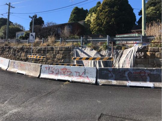 Heritage Katoomba – intersection of Cascade and Pine Streets. Council neglect of The Gully Catchment is systemic. This 19th Century heritage streetscape has been ignored for decades by Blue Mountains (City) Council with its city-centric mindset, hateful of our colonial heritage. [Photo: By author June 2024].
PART I. A Land-Use Development issue at hand
We highlight a non-complying third outbuilding development by an immediate neighbour (being a current work in progress in December 2025) located in a low density residential zoned and heritage listed area of Katoomba in the Blue Mountains. Verbal feedback is that it is set to become a new ‘backyard sauna‘ situated just 30cm from this author’s back fence boundary, yet our research shows that the build is prohibited under various local Council and Sydney Water planning rules.
Post build, the currently owner-occupied residential property (with renovated dwelling) is, news to hand, now intended to be let out to online Airbnb-type tourists for likely tourist group parties. Include also the likes of online holiday let ‘Stayz’, ‘Bookings.com’, etc. It will thus far become number 13 holiday let of a owner occupied residential house and land property within a recent trend of invading gourmet Airbnb-profiting investment owners in this heritage residential only conservation area.’
An intro heads up: Check out this and the pricing: ^https://holidaybluemountains.com/properties/
This regrettably sanctioned ‘blind-eyed’ allowance by local Council continues to undermine and engulf our quiet heritage listed residential cul-de-sac (where we’ve owned and lived as a small family since 2001). Our century-old home, which we are ongoing restoring in heritage sympathy with colonial cottages around us is listed as 1883 ‘North’s Estate’.
One serious concern is that local tenants, once prominent in this precinct have simply been priced out of available rental accommodation by greedy distant investors of residential properties around us on the band wagon of holiday letting their residential properties for many times the rental market average. Local tenants have nowhere to go but to relocate far flung from family way afar. Indeed, its sad and bad times, all encouraged by government failure and lack of interest in their constituents and all three levels of Australian government – federal, state and local!
 An unnotified, unapproved new backyard sauna right on our back fence to be part of a new Airbnb for guests to party. WTF!
A case in point is an ongoing current over-development/overcrowding of a residential property In Katoomba situated close by us, situated within a designated heritage (historical) conservation area. It is in breach of many Council development rules. Yet, despite our expressed concerns, citing of legislative breaches (ignored), then our submitted complaint, Council has just turned a blind eye and wipes its hands, citing NSW state legislation supposed exempting legislation. Council’s attitude, by some blow-in inspector from Sydney, is that property owners may do what they bloody well want, heritage be damned, neighbours be damned!
As a Conservation Consultant, this little black duck didn’t come down in the last shower!
This is a non-public photo of the subject property, only to demonstrate the reality anonymously. It is situated somewhere within a listed heritage conservation area and there exist multiple ‘rules’ regarding development for this area and this address.
Firstly we know, because firstly we have ourselves gone through the property development rules, guidelines, red tape restrictions, respecting where we are, sensitive to the heritage amenity and to our neighbours. We eventually succeeded in having our plans approved by Council way back in 2005 after much effort, research and personal cost. Our renovation project is both a sympathetic restoration and quality classic home improvement to the long neglected cottage we purchased back in 2000.
Secondly, Steven Ridd, this joint owner has spent many years since 2001 as a environmental/conservation activist initially with The Friends of Katoomba Falls Creek Valley Inc., The Blue Mountains Conservation Society, The Colong Foundation for Wilderness Inc., and The Habitat Advocate – ongoing here since 2001.
PART II. Disclaimer
(1) This article herein expresses the concerns of this author.
(2) This article is yes, political.
(3) The views, assumptions and opinions expressed in this article are the author(s) own. They do not purport to reflect the official policy of The Habitat Advocate or associates. Data references (images, documents, links, copyright, sources, etc.) appearing in this article are not necessarily controlled or monitored by The Habitat Advocate.
(4) The information provided on this [Website/in this Article/Document] is for general informational purposes only.
(5) This article and its author hold absolutely no malice towards the example property developer which is anonymously used in this article simply to highlight the ongoing systemic failures of the Blue Mountains local government to respect local heritage conservation.
(6) This article is purely intended as a critical commentary on the injustice of due process, using this property development example as a sample case study only. The property owner is irrelevant, rather it is about the failure of due process.
(7) All information is provided in good faith for informational purposes only. This article is not a guide or advice. It is citizen journalism. We make no representation or warranty of any kind, express or implied, regarding the accuracy, adequacy, validity, reliability, availability, or completeness of any information provided.
(8) Under no circumstance shall we have accept any liability to any reader for any loss or damage of any kind incurred as a result of the use of the [site/article/document] or reliance on any information provided therein. A reader’s use of the [site/article/document] and/or reliance on any information is solely at the reader’s own risk. This article is citizen journalism.
(9) The [site/article/document] cannot and does not contain [medical/legal/financial/etc.] advice. The information is provided for general informational and educational purposes only and is not a substitute for professional advice. Accordingly, before taking any actions based on such information, we encourage any reader to consult with the appropriate professionals. The use or reliance of any information contained in this [site/article/document] is solely at a reader’s own risk.
(10) Due privacy is respected in this article. No identifying information is provided in this article about the property or the owner which a member of the general public could recognise in any text or images included in this article. However, we do photograph the builder – Wayne, and identify the Council inspector, both of whom have ignored all the development rules and need to be held accountable.
(11) The purpose of this article is not about any individual property owner, but to critique and challenged an example the systemic wrong/illegal land use development approval process by Blue Mountains (City) Council over many years, and is clearly ongoing.
 This author, The Habitat Advocate’s founder, Conservation Consultant, Steven Ridd.
PART III. Issue Background
So, how does Blue Mountains ‘City’ Council’s heritage hypocrisy persist?
Well, here’s an extract map of part of North’s Estate Conservation Area in Katoomba dating back to 1883, as registered by Council, yet only on paper for starters since Council’s filed it for a decade:
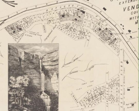 ‘North’s Estate’ – quote: just two? housing subdivision precincts (north and south) skirting the valley in between back in 1883. No! Try nine sections. This is a portion of the fully image/reality. It was no less used by Blue Mountains Council’s ignorant ring-in ‘heritage’ consultants from distant Sydney. [AUTHOR’S NOTE: An ‘artist’s impression of Katoomba Falls (in full flood) insert. The above Airbnb dwelling is within SEC IX.]
Council’s repeated actions fail to comply with its very own policies, planning documents, bi-laws, and PR gestures.
That this local government Council (‘BMCC’ acronym) patting itself on the back about in its quarterly community newsletter is blatant propaganda about all the so-called good it is doing for the Blue Mountains – its oxymoronic slogan “A City within a World Heritage Area” boasted claim.
Yeah? Like how all its stormwater and unbunded rubbish waste tips (Blackheath | Katoomba | Blaxland) up on the plateau tops seep their toxic effluent into the surrounding groundwater to watercourses and water catchments through World Heritage?
Check the mapping. Council’s Katoomba Tip (with a fancy name), situated on a ridgetop off Woodlands Road, has for decades received household garbage and an array of toxic contaminants that have been allowed to seep into the ground water and down into nearby Yosemite Creek, over Minnehaha Falls (and swimming hole) thence downstream into Katoomba Creek, Govetts Creek and into the Grose River through World Heritage. It is therefore not a wise move to swim in that swimming hole.
The same has been allowed at Council’s Blaxland Tip to contaminate adjacent Cripple Creek (appropriately named in hindsight), thence into Fitzgeralds Creek and into the Nepean River. Similarly, it is therefore also not a wise move to swim at Penrith Beach adjacent.
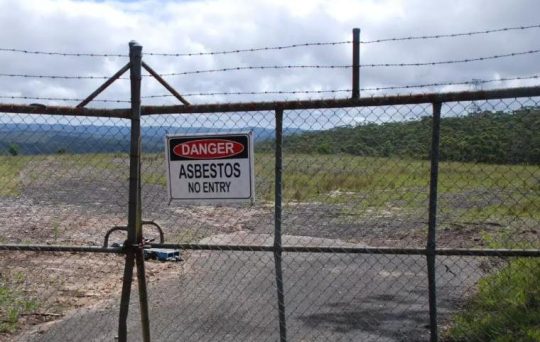 Council’s old Blackheath Tip on Ridgewell Road closed and fenced off since November 2017 due to illegal asbestos dumping. The garbage and contaminants dumped there over decades have been allows to seep toxic waste into Victoria Creek below which flows into the Grose River within the Blue Mountains World heritage Area. To date the site remains unremediated by Council.
And yeah? Like how its five public swimming pools (all chlorine saturated) respectively at Blackheath, Katoomba, Lawson, Springwood and Glenbrook each drain their entire contents each winter into the surrounding watercourses. So is that why all the native aquatic wildlife (fish, eels, freshwater crayfish and macro-invertebrates) – no longer subsist in the Blue Mountains World Heritage creeks and rivers downstream?
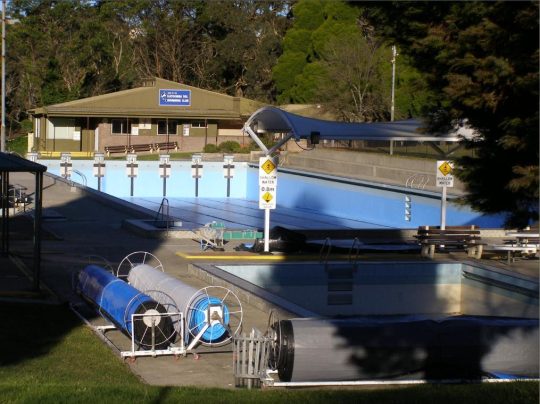 Council’s Katoomba Aquatic Centre 50 metre Olympic pool. Since first opening in 1972, it’s 2.5 million litres get drained not into the sewer system, but into the adjoining Catalina dam every winter which then drains into the adjoining creek. That creek Katoomba Falls Creek flows over Katoomba Falls (1km south) which feeds Kedumba River through the Blue Mountains World Heritage Area and supplies Sydney’s drinking water in the dammed Lake Burragorang. No wonder many Sydneysiders choose bottled water. This is just one of five Council swimming pools which all do this.
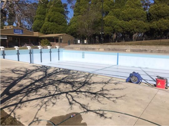 Blue Mountains Council’s olympic pool at Katoomba again the entire chorinated contents drained into the downstream Kedumba River water catchment within the Blue Mountins World Heritage Area. It happens every winter since 1972. (Photo by editor 2026-07-13).
Long dead are all downstream creeks and the Kedumba and Grose Rivers of our World Heritage Blue Mountains. Why are we still “World Heritage” listed with UNESCO if it’s just a political ruse to fuel a megalopolis snowballing Sydney’s drinking water supply? Labor’s former Member for Blue Mountains Bob Debus never answered that question. I wouldn’t drink the stuff, well knowing what goes downstream into Lake Burragorang above Sydney’s survival Warragamba Dam.
Council in its aloof chambers perched in a high rise away from the Katoomba community has thought of itself as running a “city” moreso than a regional municipality well beyond the big city high-rise and sprawl that is the metropolitan city of Sydney. Most councillors, management, staff (the ‘Council mob’) and of course the plethora of senior management’s ring-in consultants have emanated from Sydney, muchly with an urban big city mindset.
Quote: “Suburbs“? So is NSW Tibooburra a quote “suburb” as well? Wikipedia: “Tibooburra is a town in the far northwest of New South Wales, Australia, located 1,187 kilometres (738 mi) from the state capital, Sydney.” [read more]
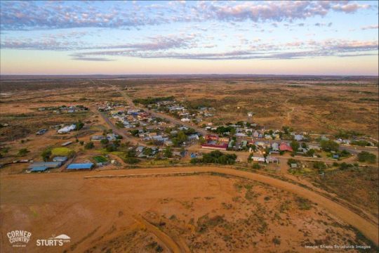 We suggest Australia’s own remote village of Tibooburra (shown here) replaces the otherwise politically-correct “sister cities” of the Blue Mountains Council – currently being exotic Sanda City (Japan) and Flagstaff (Arizona, USA). Outback Tibooburra would well save local Blue Mountains ratepayer funded councillors rorting the ‘sister city’ con on business class flights to both. We can’t image the elite councillors swapping business class exotic perks for Aussie outback reality! Hey they could claim Tibooburra as a Climate Change inspection trip!
Katoomba, for those not familiar, is not yet a suburb of megalopolis Sydney. It’s just an equivalent well distant remote village like that of Shelby in Montana, USA ain’t yet a suburb of New York City! [read more about Shelby]
Meanwhile, property investors across Australia are cashing in with Airbnb outsourcing and the NSW Government lets ’em… Check this in this subject area of North’s Estate Conservation Area in regional Katoomba, which confirms no tourist accommodation exists. Crap! … Try more that 500 Airbnbs taking over the regional Blue Mountains !!! Here’s an example…
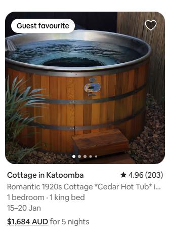 This nearby sample local two-bedroom cottage investment has two income options: (A) Market median rental at $650/week, plus Plus ulility expenses of course – electricity, gas, water. Else (B) Airbnb at $2357/week (calc: being $1684 x 7/5) – so approaching 4 times the rental income! So instead of charging rent equating to around $100 per day, try close to $330 per day! The holiday let market (Airbnb, Stayz, Bookings.com) in New South Wales is unregulated. Such has been allowed to become a housing unaffordable pandemic – wealthy baby boomers denying local young renters in favour of more lucrative wealthy fly-by tourists, mostly from overseas. Dare we term it ‘Wham, bam, thank you, ma’am’ housing. Government politicians do similar – like own multiple properties on the investment bandwagon. [Source: Airbnb]
“The average rent for a house in the Blue Mountains is around $600 – $650+ per week, with specific suburbs varying, but showing strong demand and low vacancy rates, meaning it’s a tight rental market with prices generally trending up, especially for larger homes“.
[Source: Google AI (2025) – so anonymous, so frankly who knows the truth online these days.]
Sydney is far from being an ideal city, so not an appropriate role model for any regional community. The Blue Mountains village of Leura would be a far better role model, but visitors note, the streetscape and garden plantings down Leura Mall are not the work of Council, but rather by volunteer efforts and funding by local Leura residents and Leura small retailers.
Whereas, Council loathes knowledgeable long-time locals because ex-Sydney council staff are blow-ins reaping self-interest paychecks. Council prevails in its bubble mindset in ‘north Katoomba’ conjured up tarting up the footpath in nearby Katoomba and Bathurst Streets (‘south’ Katoomba). That brain snap cost $3 million and did squat. Of course Council outsourced it to some Sydney contractor again. But it directly shut down many retailers retail for nearly a year causing many to go broke. Nice one, lower Mountains Mayor Mark Greenhill!
More recently, self-anointed Blue Mountains councillors (100% Labor Party obedient disciples) have ramped up the ‘ECO’ zealotry thus…
 “Eco City”? “Planetary Health”?
Pull the other one, Council!
This Council mob continues to remain aloof to the interests of locals and chronically blasé in attitude to respecting local Mountains heritage in all its genres. The bureaucrats are so overpaid (out of local ratepayer rates and their NSW Labor mates’ NSW government grants) and so happily unaccountable, especially the higher echelons to a salary of $300,000+ per year. Where’s the helicopter and helipad to fly in Council’s GM’s ring-in commute from Sydney to Katoomba chambers to show up for the odd (“yeah, we need you”) meeting?
As a long-time resident of the Blue Mountains region west of Sydney, The Habitat Advocate (read about us) has become accustomed with this local council’s ongoing contempt for heritage. Heritage conservation in all its genres – natural/environmental, historical, built/architectural, village streetscape, Aboriginal, you name it.
A case in point is comparing the ground-truthing reality with Council’s webpage entitled ‘Heritage Conservation Areas’ (Go to this link and read: ^https://www.bmcc.nsw.gov.au/heritage/heritage-conservation-areas).
The spiel starts off as follows:
“The Blue Mountains is well-known for the historic character of many of its towns and villages. In some towns and neighbourhoods buildings from the Victorian, Federation, Edwardian, Inter-War and Post-War eras create visually interesting and layered streetscapes. Many streetscapes are enhanced by mature street tree plantings and established exotic gardens.
Council has established ongoing recognition and protection for the many early houses and the generally traditional streetscapes found in most towns and villages of the Blue Mountains. These important historic areas are protected as heritage conservation areas. The full list of heritage conservation areas is listed in Schedule 5 of the Blue Mountains Local Environmental Plan 2015 (LEP).
The boundary and inclusions for each heritage conservation area are defined by an accompanying map, and the reasons for listing explained in the heritage inventory sheet for each area.
On 19 July 2019, areas of older housing, formerly protected as Period Housing Areas, were converted to new heritage conservation areas as part of Amendment 6 to LEP 2015. Subsequently, the Period Housing provisions of the LEP were superseded by Clause 5.10 of LEP 2015. Full details and timelines from start to finish on this planning proposal are under ‘related sites’.”
‘Propaganda‘ is generally defined as “information, especially of a biased or misleading nature, used to promote a particular cause, doctrine, or point of view.” That is what the above extract is – Council propaganda. Council says one thing yet does another. Council is hypocritical.
Blue Mountains Heritage ‘knowledge’ does NOT reside with Council management and staff
So, why do Blue Mountains councillors seek out Sydneysiders as consultants so repeatedly? Political links? Favours? Bias? Corrupt conduct? All the above? It is because the management are culturally fearful that by Council staff learning such skills, that the Council staff will gain more knowledge that the management. So by Council management engaging distant contractors for one off research tasks, at ratepayers expense of course (else funded out of NSW Government grants) the management incumbent management cannot be replaced by more knowledgeable and competent staff. Jobs for life. Like, Council’s General Manager Dr Rosemary Dillon (not a medical doctor, and elevated in government to corporatised ‘Chief Executive Officer’) has been on management for 30 years, and now gets paid $421,535 per year. Australia’s prime Minister gets $622,000 per year.
We note the tabulated list of these branded ‘Heritage Conservation Areas‘ and surprised to note that these are grouped under the tabulated heading of “Villages”. Good! This is correct! It is in contrast to many amongst the Council mob (ex-Sydney) terming the villages as “suburbs” as if the Blue Mountains is a city. It is that city-centric mindset being propagated to the Mountains locals.
We focus specifically herein on Katoomba’s ‘North’s Estate‘ listing midway down the table. By then clicking on that table’s Map and Inventory Sheet hyperlink ‘K171‘ for North’s Estate, one is directed to another Council webpage to enable one to download a PDF document. The full name of the North’s Estate “item” is ‘North’s Estate Heritage Conservation Area‘ (Local ID: K171). That document is eleven pages long in PDF and we supply a copy link, since it is in the public domain.
 Loading...
[SOURCES: Not Blue Mountains own, but yet again more of Council’s outsourced ring-in consultants from Sydney – the likes of:
-
- Paul Davies Heritage Architects Pty Ltd (of Drummoyne, Sydney)
- (Robyn) Conroy Heritage Planning (of Surry Hills, Sydney)
- Croft & Associates Pty Ltd (of Baulkham Hills, Sydney)
- Meredith Walker (of Rockdale?, Sydney),
- Tropman &Tropman Architects, of 55 Lower Fort St, The Rocks, Sydney.
Blue Mountains Council’s heritage knowledge resides not within its management nor staff. Over the years as long-time employees leave or are asked to leave, no-idea ring-ins typically escaping Sydney take on responsible roles such as in heritage yet with no local knowledge and no handover nor training. It’s like Council’s new recruit orientation going like this: “Welcome aboard, there’s your seat and your shared desk, any questions?” Indeed, we know of one of its legendary former employees Local Studies Librarian and Blue Mountains local historian, Mr John Low OAM who got ‘retired’ way too early by Council management in 2007.
“John Low was Local Studies Librarian at the Blue Mountains City Library 1982-2007. [Note: some 25 years] An active member of the Blue Mountains Historical Society, he received an Order of Australia Medal (OAM) in 2012.”
John had more local knowledge about Blue Mountains history than anyone else at Council. John has over the years written history books on the Blue Mountains and has delivered public presentations on various topics of Blue Mountains history. He researched and prepared a history of this author’s house and street back in 2001. Along with John Low, John Merriman has served as senior staff (but not management) on the Council payroll for almost as long, acquiring details and extensive knowledge and insights into Blue Mountains heritage, particularly its history back to the first colonial crossing of 1813 and prior. Like John Low, John Merriman is also an established author of Blue Mountains history, having written many books and academic papers and published online.
However, Mr Merriman has, instead of being duly promoted for his ability, dedication and long service to say Heritage Manager, he has been relegated from his history office in heritage-listed Braemar House (c.1890 guesthouse) to a basement desk in a corridor below the new Springwood Library, more inaccessible to the public for research, as he was previously. In 2024 the interior of the house was re-purposed as an art gallery featuring local visual art throughout the rooms.
Previously, during the 1980s – 2000s period, both John’s (whom this author knows well) worked under the guidance of Council’s qualified heritage architect Christo Aitken. Mr Aitken probably has more details heritage architecture experience on Council (management and staff). Alas, he was made part-time back in the early 2000s (Council senior management politics again?). So he has since set up his own heritage advisory firm consulting back to Council.
The only ones on Blue Mountains Council these days with heritage knowledge are young ring-ins from Sydney, with no local knowledge or experience – (not their fault per se) but its just as senior management wish to ensure. It’s of course so senior management can maintain a disproportionate power and influence on Council to safeguard their self-interests. Crikies, cynically Council’s heritage strategy and heritage constraints if duly respected and followed could stymie Council’s city-centric development projects, like Council’s Katoomba Falls Kiosk “revitalisation project” of 2019. Check these photos:
An original photo during construction back in 1921:
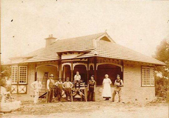 Katoomba Falls Kiosk (owned wholly by Council and heritage listed, Ref. K059)
Yet, Blue Mountains CITY Council’s anti-heritage replacement plan of 2019:
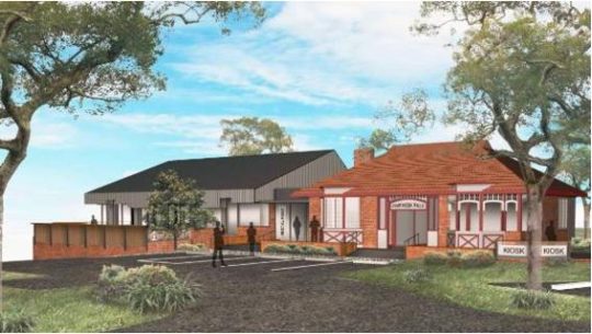
Council’s destructive design for Katoomba Falls Kiosk was rejected by the local Blue Mountains community heritage panel.
[ AUTHOR’S NOTE: We recommend that Council assess the bushland site and remove the long closed and dilapidated toilet block near the escarpment edge below the kiosk; it’s overgrown by noxious covered in weeds. Then to and undertake weed removal and bushcare to restore the native vegetation (with an aesthetic fire barrier – use Conservation Hut as a model amenity outcome].
This author went for a job on Council once, being a naïve new Blue Mountains resident (from Melbourne) in 2001. In the author’s view the interview process was corrupt and underhand.
The reason why we are writing this article is to cite yet again another example of Blue Mountains Council’s city-centric organisational culture of ignoring and acting contrary to its own policies, planning, rules particularly as they related to Blue Mountains heritage respect, conservation and sympathetic restoration. This deals with a land use development within North’s Estate Heritage Conservation Area (Local ID: K171).
 A sample of the heritage housing of North’s Estate.
This article’s writer, and The Habitat Advocate’s founder and Conservation Consultant, Steven Ridd, continues to be based in residence within the North’s Estate Heritage Conservation Area since 2001.
This area is also within what we refer to as ‘The Gully Water Catchment‘, otherwise more broadly known as Katoomba Falls Creek Valley for many decades. Within this catchment is the small natural bushland valley, termed ‘The Gully Aboriginal Place‘. In recognition that many locals (immediate locals) will not know or even be aware the specific location we are to focus upon, for introductory reference, given that we reach a wide audience, for clarity we supply the following maps zoom-in sequence to identify where we are:
PART IV. Topic Location
[ AUTHOR’S NOTE: The ‘ Issue‘ in this article is about Blue Mountains Council hypocritical treatment of heritage value of the Blue Mountains, in this case historical built heritage and colonial streetscape. The specific ‘ Topic‘ within this issue in this article is ‘North’s Estate Heritage Conservation Area’. And then a specific ‘ Case in Point‘ is the example of a current ongoing illegal and unapproved ‘ backyard sauna‘ development that breaches many rules – heritage, zoning, Council approval process, etc. which adversely impacts this author.
[A] A Global Location Map:

[B] Katoomba- Sydney Location Map:
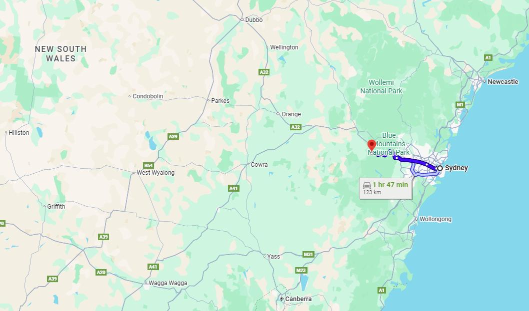 The town of Katoomba is about 100km west of Sydney by train or driving via the M4 Motorway.
[C] Katoomba Falls Creek Valley Map:
 This map section shows part of the township of Katoomba in the Blue Mountains and within that section the red circle indicates the general location of North’s Estate Conservation Area juxtaposed west of Katoomba town centre and south of the Great Western Highway/Railway. Note: ‘Wells Street‘ labelled which lies within that Estate. [Source: Google Maps]
[D] ‘North’s Estate Heritage Conservation Area’ extract historic cartilage map (within):
 This historical complete map is sourced from the real estate advertising flyer for the original housing subdivision of North’s Estate dating back to 1883. Why? Hey the railway arrived in Katoomba (then the (sandstone rock ‘The Crushers’ in 1874). An entrepreneurial gold mine! Note that Wells Street is not shown as per the current map above, but instead labelled as Kamillaroi Road, but it is one in the same. Note also: ‘Kamillaroi’ is Aboriginal; ‘Wells’ is not Aboriginal. It is probable that Council renamed it. Many of the other street names have Aboriginal. origin. [Source: ‘Draft Heritage Data Form, Blue Mountains Heritage 2016’, Blue Mountains City Council]
So hopefully now as a reader to this article, you can find the location of where we are talking about.
Prices per night under San Francisco based Airbnb…
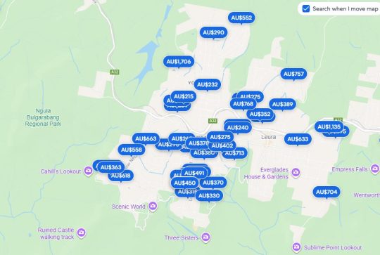 Katoomba invaded by Airbnb-style short stay holiday lets. Not all are shown on this map. [Source: Google Maps 2025]
PART V. Critique of Blue Mountains Council’s mistreatment of ‘North’s Estate Heritage Conservation Area’
[ AUTHOR’S NOTE: A ‘critique’ is not just criticism, but also evaluation and judgment, with some constructive recognition of content of merit. Whilst we do criticise certain aspects of this Council documented report, we also constructive when we consider content to be apt, based upon our own insight and research. Such critique comes from this author’s personal background (academically, professionally, research, local knowledge and reasonable longevity from living in the subject area. The author of this article is an Analyst by qualification and experience. This article aims to provide thoughtful insight and feedback of the report (the oddly entitled ‘ Draft Heritage Data Form‘). We encourage a deeper understanding of the concept and details of what comprises a ‘Heritage Conservation Area’, that it be formally completed, enhanced to best practice standards, then displayed as a comprehensive draft #2 publicly freely, consulted publicly, before being legally gazetted and thereafter legally enforced.]
Here we focus on ‘North’s Estate Heritage Conservation Area‘, being where we are based and reside. Again, this is Council’s ‘Draft Heritage Data Form‘ pertaining to this heritage ‘item’:
Loading...
This enclosed document, Council’s ‘Draft Heritage Data Form‘ pertaining to this heritage ‘item’ (or really ‘area’) warrants a few critiques, as follows:
[Our Critique #1] The form is in 2025 dated 2016, making it in December 2025 being a decade old, so sending a message that it has been since ignored by Council.
[Our Critique #2] The form is in 2025, remains a “Draft” a decade later. Why? Council does not care. Council only prepared this document (or rather was legally required to do so because of NSW Government legislation in 2015 re-branding what was zoned ‘Period Housing’ to be ‘Heritage Conservation’. Cynically, this effectively was just a tokenistic name change.
[Our Critique #3] Council has overlooked its own website concerning heritage conservation across the Blue Mountains local government area. How so? Well, its Development Control Plan of 2015 still continues to use the long obsolete term ‘Period Housing‘ (circled below). This reflects Council’s disregard towards updating its heritage management records and rules.
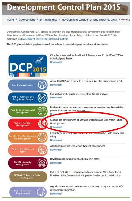
Source: ^https://www.bmcc.nsw.gov.au/development/planning-rules/development-controls-for-land-zoned-under-LEP-2015/DCP-2015
[Our Critique #4] The form was not written by Council. As highlighted above, it was researched and compiled by outsourced ring-in consultants from Sydney – the likes of Paul Davies Heritage Architects Pty Ltd (of Drummoyne, Sydney), (Robyn) Conroy Heritage Planning (of Surry Hills, Sydney), Croft & Associates Pty Ltd (of Baulkham Hills, Sydney), Meredith Walker (of Rockdale?, Sydney), Tropman &Tropman Architects, of 55 Lower Fort St, The Rocks, Sydney.
[Our Critique #5] The Statement of Significance at pages 1 and 2 requires factual historical correcting.
Yes, we note that the ‘Level of Significance’ for North’s Estate is at both ‘Local’ Level (Blue Mountain Local Government Area and at ‘State’ Level (New South Wales). So this is not insignificant.
The North’s Estate Heritage Conservation Area (HCA) in fact dates to 1876 when the then Government of the colony of New South Wales sold a large bushland parcel of the Blue Mountains plateau (western part of today’s Katoomba around the Katoomba Falls environs) to English immigrant, stockbroker, miner then property developer John Britty North (1831-1917). North subdivided the northernmost part of his property for residential development in 1883 and it became known as North’s Estate, the very first (and so oldest) housing subdivision in the Blue Mountains region.
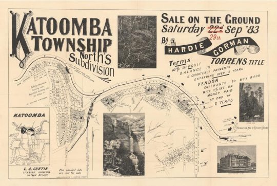 This was the original real estate advertisement for new land releases as part of then ‘North’s Subdivision’ Estate circa mid-1883 and likely in one of Sydney’s newspapers – either The Sydney Morning Herald (from 1842 – current), the Illustrated Sydney News (1853-1894), the Sydney Mail (1860-1938).
[Our Critique #6] Yes, ‘North’s Estate’ survives in two separate precincts (subdivision sections) on either side of the steep gully (The Gully) at the head of North’s property where it met the highway (Bathurst Road). The larger area surrounds his family home near Bathurst Street, and the smaller is sited on the small ridge extending west from Cascade Street near the Carrington Hotel.”
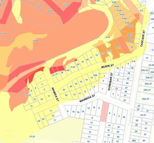
However, a closer research examination of the above original reveals the extent of North’s landholding ownership and of his proposed subdivision. There were in fact a total of nine Sections (numbered from west to east labelled with Roman numerals ‘SEC I’ to ‘SEC IX’). The HCA chooses to only include the surviving abutting ‘SEC V‘, ‘SEC VI‘, ‘SEC VII‘ and ‘SEC VIII‘ (comprising the northern precinct south of Bathurst Road between then North’s Colliery Siding (coal shale railway west) (now Valley Road), and Reserve Road (now Cascade Street). The southern precinct ‘SEC IX‘ is the smaller cul-de-sac located toward the south, juxtaposed to the west of Reserve Road (now Cascade Street). SEC 1, SEC II, SEC III, SEC IV allotments were not sold in this process, possibly due to lack of sufficient demand and the walking distance from the then new village of Katoomba to the east around the railway station (shown).
Note, more southern isolated smaller ‘SEC IX‘ is bounded by just five streets, being Cascade, Murri, Kundibar, Waimea and Warriga Streets. And this SEC IX (Section Nine) features a vacant 32 housing allotments in total. (Image curtilage extract below).
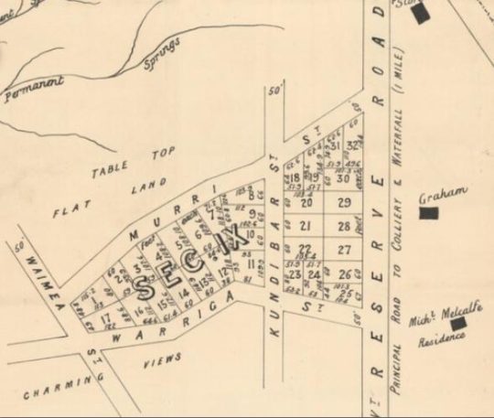 Close up extract map of North’s Estate from the original 1883 real estate advertisement above. The area size is about 200m (E-W) x 100m (N-S)
This is where The Habitat Advocate base resides. It is also especially why, one takes a special interest in this matter. We are here, home long located in North’s Estate of 1883 ‘SEC IX‘.
Yes, we after 25 hard-working and costly investment renovation years, take a focused interest in what happens in our neighbourhood that could try to ever undermine it.
[Critique #7] Yes, the two residential precincts of North’s Estate dating from the late 1900’s to 1940’s feature and retain “the aesthetic or historic qualities of the original streetscape.” Yes, “many (of the houses) make a significant contribution to the HCA through their fabric and aesthetic heritage values.” Yes, both precincts are “distinguished by notable examples of substantial homes interspersed with Victorian and early 20th century cottages.” Yes, “the physical link between North’s house and his mine remains interpretable through the open space along the gully leading to Katoomba Falls (not within the HCA).”
However, the observation that there were “no formal guesthouses or residential hotels of the type of scale that are found throughout the main spine of the town” is incorrect. Historical records account that in fact, there were back in 1883, the Balmoral House (guesthouse), the ‘Montrose’ guesthouse (where Dan Murphys current is today), Glenample guesthouse and The Katoomba Hotel. They were all situated along Bathurst Road (which was then the main highway between Sydney and the town of Bathurst) and positioned walking-distance to the then newly built Katoomba Railway station (opened on 2nd February 1874 as ‘Crushers’). There were of course no motor cars back then. The last three mentioned guesthouses no longer exist.
The advertising flyer includes ‘SEC VIII‘ with earlier buildings along the Bathurst Road including an inn, school, stores and two butcher shops. It was because the original village of Katoomba from 1883 was centred along Bathurst Road (the road to Bathurst) with the railway station from 1874 running parallel according to gradient. These buildings were present before North’s Subdivision adjoining to the west and south.
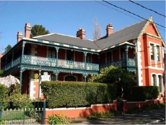 Balmoral Guesthouse as it is today (built in 1880) at 196 Bathurst Road Katoomba. Built as a guesthouse this two-storey (13 room) Victorian Italianate villa was situated cleverly convenient level street walking distance (200m) from new Katoomba railway station then, recalling well before the advent of motor cars!
At this juncture, we point out to readers that prior to 1813, the Blue Mountains was a wild bushland plateau inaccessible by New South Wales colonists. It had been indigenous Aboriginal land for perhaps 60,000 years prior, traversed and used by various regional tribes during warmer seasons. Following colonial exploration, and once the first rough road (Cox’s Road) was constructed in 1815, from the 1820s, settlement, land clearing for pasture (grazing) and a few timber inns were built for travelling settlers over the Blue Mountains. However, besides a few small hamlets that evolved from squatting and the odd small plot grant by the colonial government; no formal housing subdivision existed anywhere across the Blue Mountains until 1883 with the advent of North’s Subdivision (later referred to as ‘North’s ‘Estate’ once housing construction commence). This was the year that informal ‘Crushers’ was formerly re-named as Katoomba by the colonial government in Sydney.
[Critique #8] Yes, the character of the residential development of North’s Estate (HCA) is low-scale and most buildings are modest..cottages and houses that are representative of their era (1880 to Federation and up to 1940). The area is solely classic residential – detached dwellings of 2 plus bedrooms, pitched rooves, front yard and backyard even if small. [AUTHOR’S NOTE: that is a key factor of why we selectively chose to buy in this area when we did back in 2000. Property owners deserve an ownership right to expect that a low-density residential area in which they buy will never be downgraded. This particular area was deemed ‘Period Housing’ when we purchased our house back in 2000. That gave us reassurance.]
[Critique #9] Holiday accommodation banned.
“Further research would be required to determine if any of the properties were used as holiday rental properties or guesthouses. The eastern end of the Bathurst Road streetscape includes commercial land uses, most of which are located in new buildings, either infill or built following the demolition of earlier buildings.”
“This small precinct is physically remote from the centre of Katoomba today and is unusual in the way that it includes relatively few properties that service the tourist industry, demonstrating instead the characteristics of a small residential area. The subdivision includes the Bathurst Road, Walgett, Kamillaroi and Murri Street precincts.”
[AUTHOR’S NOTE: We criticise why in the report did the consultants introduce these precinct terms for North’s Subdivision? The SEC I through to SEC IX are the original identifiers. The so-called heritage consultants ought to have professionally respected that original heritage labelling rather than try to ‘reinvent the wheel’ and impose their own labelling. Some heritage consultants!]
The following statements describe the mostly pre-Federation character and fabric of the purely low-density detached residential cottage housing of North’s Estate Heritage Conservation Area, to which we concur.
(9A) “This small precinct is physically remote from the centre of Katoomba today and is unusual in the way that it includes relatively few properties that service the tourist industry, demonstrating instead the characteristics of a small residential area.” [AUTHOR’S NOTE: This is a false statement and increasingly so over recent years to 2025 at the time of writing. This North’s Estate Heritage Conservation Area (HCA) has been ongoingly swamped by Airbnb short-stay holiday lets by the dozens. Such tourist accommodation is in breach of the HCA. ]
(9B) “The typologies most commonly found in the area include the simple symmetrical Victorian cottage (hipped or gabled), simple L-plan Edwardian cottage, Federation house with return verandahs and Inter-War bungalow in both the Sydney-style and designed variations. Later infill is mainly 1970s style project homes with a recent large infill at the south-eastern end of Buti Street. Almost all structures are a single storey in height.”
(9C) “Murri, Warriga and Kundibar Streets have a similar character to Walgett and Wells Streets, with a range of more modest built forms, mainly late Victorian/early 20th century cottages and small houses, plus examples of later styles and periods.”
(9D) “Physical condition and Archaeological potential Not investigated, but the location of at least some of the pre-1883 structures along Bathurst Road are shown on the subdivision plan and have significant archaeological potential. The area in the vicinity of the settlement has the potential for archaeological deposits related to the use of this area.”
(9E) “The streetscapes within the North’s Estate HCA are clearly differentiated from each other and from the surrounding area. Their common underlying configuration of an outer loop road attached to the main road with internal connecting streets has facilitated the cohesive aesthetic character within the area with a clearly expressed overall consistency in the scale, form and siting of individual buildings.”
(9F) “The streetscape of Murri Street also contributes to the aesthetic heritage values of the HCA, with sandstone-faced split-level roadways separated by traditional timber arras fencing in places. It features quality houses that are good and representative examples of their architectural style. Many of the houses in this part of the HCA have undergone extensive alterations and additions to facilitate the capture of the views from the properties, but the overall character remains one of a simple, traditional streetscape on the edge of the bushland. As a group they create a strong sense of place that helps to define the aesthetic character of their streetscape.”
(9G) “Fences are low, visually transparent and are generally appropriate for the period of development. There is relatively little evidence of gentrification or reworking of historic fabric.”
(9H) “The buildings in the area include a good range of typologies from the main period of development (1880s to 1940s). Although many houses have had minor alterations and additions, most have retained the integrity of their original form and continue to contribute positively to the quality of the streetscape.”
(9I) What is omitted are street by street photos by the researchers rather than just descriptive text and few old maps.
[Our Critique #10]
The consultant’s report is vague toward the ending pages, mentioning but not discussing matters of significance such as ‘social significance’, ‘technical/research significance’, ‘SHR” (we presume this means ‘State Heritage Register’, yet it is not so defined on the report), ‘rarity’, ‘representativeness’, and ‘integrity’. Perhaps the unfinished repoirt was due to consultants running out of time or funding or just moved on to other work.
[Our Critique #11]
Much streetscape and housing architecture information is omitted from the draft HCA.
[Our Critique #12]
The report’s recommendations are similarly very brief, however the statement “retain low density residential zones” is a clear message. The emphasis is on the public domain (streetscape) within the HCA, moreso that the architectural character, integrity in preserving the colonial cottage style of the Victorian era. Else it concludes with rather generic waffle at the end, possible sourced form a previous report.
[Our Critique #13]
In any case, Council has since done nothing about implementing the recommendations, or any further research, but as usual just filed it. the HCA exercise was merely to comply with the NSW Government’s change in terminology from ‘Period Housing’ to ‘Heritage Area’ in its DCP2015 from Blue Mountains LEP 2005. It seems that is all that Council has done, which from one’s experience with Council’s many Plans of Management, is typical of Council management (mismanagement).
PART VI. A Case in Point
In 2006, an immediate neighbour of ours within North’s Estate Heritage Conservation Area (HCA) ‘SEC IX’ (per the mapping above) had purchased a residential property having a pre-existing heritage detached residential dwelling, so at the time of writing, close to 20 years ago. Extensive renovations over the years in sympathy with the colonial cottage style character of the property and the HCA were undertaken, likely at substantial cost. For ethical privacy reason, we choose not to identify the property herein, since the issue we raise is of a failed process by Council.
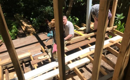
We became aware of a new third outbuilding being constructed in the backyard in November 2025 – an outdoor backyard sauna. But by Sunday 6th December 2025, the scale of that build and its 350mm close proximity to our fence seemed to be an over-development of the site. We’re talking about an under a 700m2 block in a low density residential zone in a designated heritage area.
We’ve also learned subsequently that the property is to be yet another Airbnb-style holiday let investment, so no longer to be owner-occupied. It will add to the more than an dozen holiday lets within the tiny (HCA) ‘SEC IX‘. None of this this was previously communicated to us as an immediate neighbour. We phoned and left a non-contextual voice message just for the owner to call one back. Ignored.
Frustrated, here are the subsequent photos from our side of the fence of this new build in progress at the time of writing:
 Note that due to the small size of our own residential block, some time ago we planted clumping (non-running) low maintenance bamboo hedging to create mutual privacy between our neighbours backyards, instead of say high maintenance dark conifers. Following our prior consultation with adjoining neighbours, our choice with the clumping bamboo to establish mutual privacy was welcomed by all our adjoining neighbours.
 Note to the left of the photo the previous entertainment pavilion build (new outbuilding #2) i addition to a carport (outbuilding #1) on site. Yet legally, only two outbuildings (not three) are permitted in this low density residential area. After which 3+ outbuildings downgrades this low density heritage residential area to medium density and ultimately to high density.
 Another proximity photo shows the roof rafter of this new backyard sauna to be just a 350mm (1 foot) setback from our boundary. Unbelievable! The new sauna wall is to be just 500mm setback from our fence. This setback is illegal. It has to be a minimum setback to any boundary of 1400mm. It is a very arrogant intrusion by an adjoining neighbour.
 And we’re not exaggerating our measurements. Evidence by us from our side of the fence always!
 This backyard sauna fabrication is using cheap and combustible pinewood which is illegal in our bushfire prone fire zone. This is a cheap cowboy backyard build. We soon learn it’s been going ahead without Council knowledge let alone approval. Our home is dangerously exposed potentially to this a large bushfire torch on our boundary – and it’s all being setup for Airbnb holiday let parties using the pavilion and now this sauna as sales features on our residential boundary for Christ sake!
So, inquisitive, one wrote to Blue Mountains Council (BMCC) by email on the Monday morning thus:
Correspondence #1:
Monday 8th December 2025, one phones Council and reports the matter to the Council’s Customer Service Department.
A CSR (Customer Service Request) is requested by self from Council for the record: #634961.
Correspondence #2:
Same day, one sends a followup email to Council with the details and including four relevant photos as evidence of work in progress, thus:
Attention: [Council’s Health & Building Surveyor]
Blue Mountains City Council
Locked Bag 5
KATOOMBA NSW 2780
8th December 2015
Dear Mr XXXXXXXX,
I wish to enquire with you at Blue Mountains City Council whether a current backyard construction adjoining my residential property has BMCC approval and is appropriate.
Currently, there is a building construction underway at (SUBJECT DEVELOPMENT SITE) Katoomba over my back fence adjoining our property that has just become obvious to me, yet it would appear to be perhaps excessive? I attach a few current photos of the work in progress from our property for your information for clarity. This is a heritage residential precinct.
My property is located at (SUBJECT DEVELOPMENT SITE) Katoomba and in recent weeks I have noted that a sizeable building development is underway that is very noticeable and comes to being measured just 350mm from our back fence and looks to become well above our fence line once completed. Our neighbour, whom we are otherwise amicable with, is currently in the process of having this construction become a new backyard sauna. Of late we have noted that it is very dominant and close to and rises above our rear fence line. It is unclear whether this will entail an associated noise impost once operational.
Is Council aware of this new construction development and does this have Council permission and approval? Since I have received no such written notice of this development.
Kind regards,
Steven Ridd
Correspondence #3:
Two days later, on Wednesday 10th December 2025, one phones Council to followup the Monday request.
Council advises that as yet no ranger or investigator has been assigned to this matter. One requests a documented ‘Customer Service Request reference number (CSR) and is advised of CSR #634109 about of this raised neighbourhood concern.
Council advises that the Health & Building Surveyor addressed in one’s email is not with Council (presumable he must have resigned and Council has deleted all records of his senior staff role existence). One had dealt with him co-operatively for over a decade regarding one’s own legitimate and approved development application.
Correspondence #4:
On Friday 12th December 2025 four days later, one received its first reply from Council on this reported matter, thus:
“Dear Mr Ridd,
Council do not hold records of the development you have described at (SUBJECT DEVELOPMENT SITE) Katoomba.
The State Environmental Planning Policy (Exempt and Complying Development Codes) 2008 (‘Exempt Code’) outlines development that can be undertaken without requiring development consent.
The photographs you have provided show the structure will likely largely meets subdivision 9 of Part 2 of the Exempt Code when built, except perhaps the distance to the boundary.
Would you like this structure investigated for distance to the boundary? If so, please let me know.
Please be aware that Council does not disclose to a person who complained about them, but it may be very obvious to you neighbour that it was you.
Regards,
Judy Le Breton | Senior Investigations Officer | t: 02 4780 5000 | e: council@bmcc.nsw.gov.au
Blue Mountains City Council | council@bmcc.nsw.gov.au | www.bmcc.nsw.gov.au | Locked Bag 1005 Katoomba NSW 2780 ”
Some relevant observations at this juncture:
(i) One’s presumption had been correct, that the owner had not sought nor obtained Council approval for the third outbuilding – the sauna;
(ii) There are no plans or design drawings for the sauna. As an immediately adjoining neighbour to this construction development, one is entitled to be notified in advance of such a development;
(iii) How can this development (over-development) be exempt from planning controls such as the HCA and Council’s rules – its Development Control Plan 2015, DCP 2015 Amendment 8 Part D – Heritage Management, and that this residential area is zoned ‘R2: Low-Density Residential’?;
(iv) Why should one as a resident be required to research and interpret State Environment Planning Policy? This is the task of Council;
(v) Is this person Judy Le Breton, a supposed Senior Investigations Officer in any way qualified to assess this development for its compliance with Council’s planning rules?
Correspondence #5:
Same day, on Friday 12th December 2025, one phone’s Council requesting to speak with Ms Le Breton, but she is not there and so leaves a message.
Another Customer Service Request number is issued to Mr Ridd: ‘CSR 634961‘.
Correspondence #6:
Same day, on Friday 12th December 2025, one emails Council referencing CSR 634961 and attaches a copy of the North’s Estate Heritage Conservation Area document, obtained from Council’s very own website. This is because Ms Le Breton in her email reply did not mention this very relevant document, nor mention Council’s relevant zoning requirements, nor Council’s the DCP 15 Heritage Management, but only state policy.
Correspondence #7:
Then on Friday 12th December 2025, Mr Ridd emails Ms Le Breton as follows:
RE: (Subject address) Katoomba – new development adjoining (CSR 634961)
Hello Ms Le Breton,
Thank you for your email reply.
However, I reported this to Council by phone last Monday 8th December 2025, so some four days prior. It is disappointing that this is the first that I have had Council contact me about this. Had the weather not been rainy this past week, the neighbour ‘Wayne’ may well have finish the build by now.
I follow with Council by phone on Wednesday 10th December and was told that a ranger had not yet been assigned to the matter.
Yes. I wish to check due process and the legalities concerning this new development. I don’t mind in the slightest about the owner knowing it is me (over the corner side fence) raining my concerns.
I have known the previous owner (SUBJECT DEVELOPMENT SITE) for over the past 15 years on a very amicable basis, not just as adjoining neighbours but as good friends.
I have today followed up again by phoning Council after receiving your email reply below.
My Concern that should be addressed by Council in this matter:
(1) I am concerned that you seem to be fobbing me off to research some state legislation online. Is that not your task or that of Council’s Development Monitor Team to check? This would seem lazy?
(2) My wife and I had our own land use application submitted and approved by Council submitted back in 2005 (Reference X/XXX/2005). It subsequently gained substantial commencement status. We had to comply with the many rules for the renovations and extensions and the conditions of consent. So we are aware of the rules and restrictions for our own development which after many years remains ongoing.
(3) One of the rules is that our building may not extend to within 1400mm from any boundary on the property land site. However, this new outdoor building measures just 350mm from our boundary.
(4) I note that you say Council is not aware of this development at (SUBJECT DEVELOPMENT SITE) Katoomba (literally adjoining part of our back fence).
(5) I point out that the fabrication is being made using pine timber, however this is in breach of the bushfire regulations since both properties are situated within a bushfire high risk zone (<50 metres) , so demanding non-combustive construction material (not pine) for all exterior cladding.
(6) This build is a second one that adjoin this, (The “pavilion”) probably also in fabricated in pine.
(7) In contrast, all our exterior materials are in approved Merbau hardwood or concrete sheeting (on a temporary basis). It has thus far cost us a considerable outlay over the years
trying to do the right thing by Councils rules and the legislation.
(8) This residential area is a designated heritage conservation area known as North’s Estate heritage Conservation Area (Reference K171) (see attached copy and link to Council’s website ^https://www.bmcc.nsw.gov.au/documents/map-and-heritage-inventory-sheet-k171 ) The heritage conservation assigns a high value to the amenity and streetscape to this rare purely residential area. It seems you are not aware of this special heritage conservation classification that include both xxxxxxxxxxx and xxxxxxxxxxxx Streets.
(9) It is not supposed to have any tourism development, yet over recent years numerous homes have been converted to permanent Airbnb’s. It is my understanding that this is planned with (SUBJECT DEVELOPMENT SITE), with this new build become a outdoor sauna and shower in the garden. Others include 4, 7 (x2), 10, and 8 Kundibar Street – none with local resident notification and probably nor Council notification, awareness, nor approval. So they would thus be each in breach of the classification. Quote at page 7: “it does not provide tourist accommodation or facilities.”
(10) We have received no plans or written information from the owner about what is proposed in this “sauna” – such as a potential fireplace, noise, perhaps amplified music, hours of use. As such this would seem to be an illegal development.
(11) I wrote to (Council’s Health & Building Surveyor) on this , however he seems to have retired or moved on from Council. We’ve dealt with him for many years he was very knowledgeable about development matters and quite helpful and responsive.
Please investigate this onsite ASAP and not after Christmas and New Year break, since the thing will likely be operational by then. Feel free to contact me to arrange access to our property for inspection from our side of the fence.
Yours faithfully,
Steven Ridd
Correspondence #8:
[On Friday 19th December 2025, Mr Ridd from his backyard happened to observe the subject owner talking with an unrecognisable man close to the back fence – presumably an inspector from Council. Then on Monday 22nd December 2025, Mr Ridd received to following email from Council]
(Subject Address) Katoomba (CSR 634961)
Dear Mr Ridd,
I have inspected the structure being built at the rear of (SUBJECT DEVELOPMENT SITE) Katoomba. I am satisfied it meets the provision of the State Environmental Planning Policy (Exempt and Complying Development Codes) 2008 (‘Exempt SEPP’), and no action is to be taken by Council.
These codes relate to development that can be undertaken without requiring the consent of Council. I have addressed your noise concerns with the owner of 5 Warriga Street. I am satisfied with the noise mitigation measures that will be employed, however should noise become an issue, you are able to seek a Noise Abatement Order via the Local Court.
The structure being built, whilst within a Heritage Conservation Area, is not a Heritage Item. This means that many of the Exempt SEPP development provisions (including those that apply to the structure being built at (SUBJECT DEVELOPMENT SITE) can be applied without seeking the approval of Council.
Assessing compliance with state legislation is a major part of my job. The legislation largely determines what is allowed and what is not.
In relation to your Airbnb concerns, the Department of Fair Trading changed the rules around short term rental accommodation and it is no longer regulated by Council.
Regards,
Judy Le Breton | Senior Investigations Officer | t 02 4780 5000 | e council@bmcc.nsw.gov.au
Blue Mountains City Council | council@bmcc.nsw.gov.au | www.bmcc.nsw.gov.au | Locked Bag 1005 Katoomba NSW 2780
Correspondence #9:
22nd December 2025
Hello Ms Le Breton,
I total reject your rejection of the rules.
You are acting in breach of Council’s own regulations.
You have offered me no justification for doing so.
So, I am going public on this issue, having first tried my best through normal channels unsuccessfully.
Yours faithfully,
Steven Ridd
Our Critique:
(1) The sole person observed by Mr Ridd who inspected onsite the Friday prior to Ms Le Breton’s email decision of the following Monday, was not female.
(2) For a Council development compliance inspector to firstly admit that Council had not been notified of the development and then to approve it anyway is tantamount to incompetent conduct, if not corrupt conduct, in our view.
(3) We deal with Ms Le Breton’s obfuscating reliance upon State Environmental Planning Policy (Exempt and Complying Development Codes) 2008 (‘Exempt SEPP’) further on, but frankly what is her job and is she doing it? So Mountains backyarders don’t require the consent of Mountains Council these days? Hey, well that sends a message! May be I should build meself a backyard moonshine still – surely give Mountains Culture Brewing a run for its money, I reckon. Got the room and all.
So, what a slack job Council Senior Investigator Le Breton as a compliance inspector quoting exempt State legislation by default. Having the shallow interest of a politician and the skills of a Grade 3 school student in …our view.
(4) Noise? Council Senior Investigator Le Breton dismisses noise issues. Back on me: She again cops out and quotes: “however should noise become an issue, you are able to seek a Noise Abatement Order via the Local Court.” Her cost? Her involvement? Nuh!
(5) Senior Investigator Le Bereton quoted response: “The structure being built, whilst within a Heritage Conservation Area, is not a Heritage Item.” Yes, so is that not a breach of the HCA? What if this property owner constructs another six outhouses and houses a dozen holiday makers on his residential site. Council to reckon: nothing to see here? All EXEMPT?
(6) Quote: “In relation to your Airbnb concerns, the Department of Fair Trading changed the rules around short term rental accommodation and it is no longer regulated by Council.”
So no limit? What does heritage management mean Senior Investigator Le Breton? Nothing, a free for all? Le Breton has the slackest job on Council – do nothing, roneo copy and email state legislation. A eight year old could do that. Go back to megalopolis Sydney!
PART VII: Blue Mountains Planning – Shed Development Rules
[ AUTHOR’S NOTE: Council is treating this sauna (to be) as no more than ‘a shed’.]
“In the Blue Mountains, a shed may be considered “exempt development” and not require council approval if it meets specific size, height, and setback criteria under the NSW planning rules.
The key setback requirement for an exempt shed is generally a minimum of 900mm from each boundary.” [AUTHOR’S NOTE: The owner’s setback of the sauna wall framing from Mr Ridd’s back fence is just 500 mm. It will be less than that once the wall cladding is added. The lean-to roof currently has one rafter 350 mm from the fence.]
Shed Requirements for Exempt Development in NSW
“If your shed meets all the following criteria (from the State Environmental Planning Policy (Exempt and Complying Development Codes) 2008), it is exempt and does not need a Development Application (DA):
“Size: No larger than 20 square metres in floor area in residential zones (50 sqm in rural zones).”
[Our Comment: The owner has not disclosed the eternal dimensions of the build to anyone, including Mr Ridd or to Council. It appears to be approximately 4m long (along tne fence), 2.5m deep and 2.5m high with a lean-to roof, so this make the overall floor area 10m2, not allowing for the addition of the proposed outdoor shower. But it seems to be being designed as it is constructed. There are no known design plans. Observations are that the owner and builder seem to be in regular onsite discussions as to what to do – making it up as they go along.]
“Height: No higher than 3 metres above ground level, or 2.4 metres if built within 1 metre of a boundary.”
[Our Comment: The subject build is within 500mm of our boundary, perhaps the lean-to being 2m at the fence line, rising to 2.5m on the other garden side.]
“Setback: A minimum setback of 900mm (0.9 metres) from each property boundary.”
[Our Comment: As mentioned above in this part, the owner’s setback of the sauna wall framing from Mr Ridd’s back fence is just 500 mm. It will be less than that once the wall cladding is added. The lean-to roof currently has one rafter just 350 mm from the fence.]
“Location: Must be located behind the building line of the main house.”
[Our Comment: Yes, from a public ‘streetscape’ narrow perspective, it is. Yet, it encroaches on the amenity of an adjoining neighbour, Mr Ridd. Neither the owner nor Council has not engaged in any resident consultation process in relation to (A) the North’s Estate Heritage Conservation Area, nor (B) Zoning of this R2 Low-Density Residential Zone, nor (C) This particular Backyard Sauna development]. Council frankly couldn’t give a shit.
“Number of structures: There are generally no more than two exempt development structures (e.g., sheds, carports) per property.”
[Our Comment: The subject owner has (1) a renovated carport, (2) a newly constructed (<4 years) pavilion (large entertainment shed – dimensions 5m (L) x 3m(D) x 3m (H) without any Council approval]
“Materials: If the property is on bushfire-prone land, the shed must be constructed of non-combustible materials. (Much of the Blue Mountains is bushfire-prone).”
[Comment: The subject property’s backyard sauna is zoned within ‘Bushfire Prone Land – Vegetation Buffer’ under Council’s emapping software, yet the pinewood fabrication is highly combustible and so a prohibited material.]
 Bushfire Prone cadastral mapping of the subject section of North’s Estate ‘SEC IX’, without specifically identifying the subject property. [Source: Spectrum Spatial’s e-mapping on Blue Mountains Council’s website’s Interactive maps]
 The subject backyard sauna under construction. [Photo by author from fence line].
“Other conditions: It cannot be a shipping container and must not interfere with access or fire safety measures of another building.”
[Comment: The backyard sauna poses a fire risk due to the combustible construction materials used, the need for a heating device to make the sauna functional, and likely no planned allowance form first retardant measures such as a fire blanket and fire extinguishers. In addition, the owner’s intention to soon dedicate the entire property to being an Airbnb holiday let would mean that such guests would likely not be trained in fire safety or fire supression in the event of a fire in the sauna. The close proximity of the backyard sauna to Mr Ridd’s rear fence would severely restrict fire fighting access Mr Ridd’s property from the rear.]
Neighbour Notification and Disputes
“Exempt Development: While there is no formal requirement to notify neighbours for exempt development, it is always recommended as a common courtesy to maintain good relations and prevent future disputes.”
[Our Comment: Council’s has advised that the property owner has not notified Council. The property owner has not notified adjoining neighbour (property owner) Mr Ridd. Mr Ridd has disputed Council’s lax interpretation that this backyard sauna is deemed ‘exempt development‘ under the the NSW SEPP (Exempt and Complying Development Code) 2008. Whilst physically minor in scale, compared with say a dwelling, the build fails to meet any definition of being a shed and breaches multiple rules as this article herein highlights and explains. is not a shed per se. It does indeed require formal council planning or construction approval, as well as notification to adjoining neighbours likely to be adversely impacted, and there be an opportunity for such neighbours to raise concerns and possible objections about such likely impacts. ]
“Development Application (DA): If your shed does not meet all the exempt development criteria (e.g., you want to build closer than 900mm to the boundary), you will need to submit a DA to the Blue Mountains City Council. In this case, neighbours will be formally notified during the exhibition period and have an opportunity to make submissions or raise concerns.”
[Our Comment: Hello! It ain’t just a shed. Construction needs to be halted immediately. It does not meet all the exempt development criteria (e.g., it is under 500mm setback from the side boundary). A DA needs to be submitted to the Blue Mountains (City) Council. Neighbours need to be formally notified during the exhibition period and have an opportunity to make submissions or raise concerns.]
“Actionable Steps
“Verify your property’s zoning and constraints: Use the NSW Planning Portal Spatial Viewer to check your specific property’s zoning, bushfire rating, and other potential constraints.”
[Our Comment: Been there with the bushfire rating, but more assessment is to be made about other zoning constraints herein in this article below in ‘PART IX. Scrutiny of LEP 2015/ DCP 2015 Zoning Compliance’]
“Confirm the rules: Review the full list of conditions in the State Environmental Planning Policy (Exempt and Complying Development Codes) 2008 and the Blue Mountains Development Control Plan (DCP) 2015 on the Council’s website.”
[Our Comment: It would have been wise for the property owner to have done so in advance, or sought professional advice. He would have saved time and money and effort and dispute with Mr Ridd, who would have preferred to utilise his Christmas break doing better things than dealing with a unnecessary dispute.]
“Contact the Council: If you are unsure whether your project is exempt, contact the Blue Mountains City Council’s planning department for advice.” [Our Comment: It would have been wise too.]
[ AUTHOR’S NOTE: Council is treating this sauna (to be) as no more than ‘a shed’. However, this is incorrect. Unlike a shed, a sauna is not for storage (such as for garden tools) but instead intentionally intended for people to sit in. It requires a heat source (usually electricity). That presents a fire risk if not correctly installed by a qualified electrician with experience with sauna installations who knows the risks and follows the rules and uses the factory approved heating device(s). A sauna necessitates steam , so it requires a water source and water heater which creates noise. This particular sauna of the owners is to also have an adjoining cold shower attached. It will be part of a new Airbnb offering, one that has become popular overseas such as in Finland for decades. This then will attract multiple guests to party right by one’s back fence, so replacing what has for decades been a quite back corner of that owner’s backyard. It will risk posing a new annoying noise problem. With the electricity supply, this will facilitate guests to play music – how late and how loud? Council has abrogated it responsibility in controlling this unauthorised unplanned, unknown development in many ways.]
PART VIII: State Environmental Planning Policy (Exempt and Complying Development Codes) 2008
2.17 Specified development
The construction or installation of a cabana, cubby house, fernery, garden shed, gazebo or greenhouse is development specified for this code if it is not constructed or installed on or in a heritage item or a draft heritage item, on land in a foreshore area or in an environmentally sensitive area.
[ AUTHOR’S NOTE: “In English, “ cabana” refers to a small, often freestanding shelter typically found near pools or beaches. The term originates from the Spanish word “cabaña,” meaning hut or cabin, and has evolved to describe structures that offer a combination of shade, privacy, and leisure amenities in outdoor settings.”. Such a structure was recently built by the subject owner in his backyard, which he dubs ‘The Pavilion”. The backyard sauna is to be a similar example of the build.]
 A sample cabana
2.18 Development standards
(1) The standards specified for that development are that the development must—
(a) (Repealed)
(b) not have a floor area of more than—
(i) on land in Zone RU1, RU2, RU3, RU4, RU6 or R5—50m2, or [OUR COMMENT: these are rural zonings]
(ii) on land in any other zone—20m2, and
(c) be not higher than 3m above ground level (existing), and
(d) be located at a distance from each lot boundary of at least—
(i) for development carried out in Zone RU1, RU2, RU3, RU4, RU6 or R5—5m, or
(ii) for development carried out in any other zone—900mm, and
(e) if it is not on land in Zone RU1, RU2, RU3, RU4 or RU6—be located behind the building line of any road frontage, and
(f) not be a shipping container, and
(g) be constructed or installed so that roofwater is disposed of without causing a nuisance to adjoining owners, and
[OUR COMMENT: There is as yet no indication that any guttering to the backyard sauna (to be) is to be constructed/installed. As mentioned, no known design plans for this backyard sauna exist. The lean-to roof area slopes back towards and very close to Mr Ridd’s fence. The roof area is estimated to be 4m x 2.5 so an area of about 10m2 . In the frequent event of heavy rainfall that roofwater would be sheeted on to Mr Ridd’s back fence causing a nuisance and likely damage, including timber rot. There is no know stormwater management known].
(h) to the extent it is comprised of metal components—be constructed of low reflective, factory pre-coloured materials if it is located on land in a residential zone, and
[OUR COMMENT: The materials are unknown, since no known design plans for this backyard sauna exist. However, what has been observed is the use of pinewood for the wall and floor framing].
(i) if it is located on bush fire prone land and is less than 5m from a dwelling—be constructed of non-combustible material, and
[OUR COMMENT: What has been observed is the use of pinewood for the wall and floor framing, which is highly combustible and so prohibited in this bushfire prone zone].
(j) if it is constructed or installed in a heritage conservation area or a draft heritage conservation area—be located in the rear yard, and
(k) if it is located adjacent to another building—be located so that it does not interfere with the entry to, or exit from, or the fire safety measures contained within, that building, and
(l) be a Class 10 building and not be habitable, and
(m) be located at least 1m from any registered easement
[Our Comment: The subject backyard sauna is being constructed directly vertically above a Sydney Water Sewer main, which runs from the top via a manhole access on Mr Ridd’s side of the fence under the back fence and directly below the new backyard sauna construction. This is illegal. Mr Ridd became familiar with such a law during the process of his own renovation approved by Council back in 2005 involving stormwater management planning.]
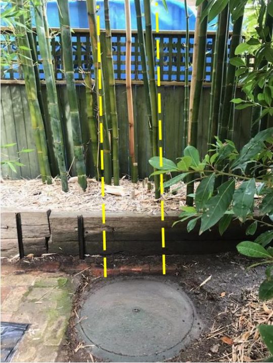 Mr Ridd’s backyard adjoining the subject property has a pre-existing trespassing sewer main from decades prior with a manhole access (shown above) near the back boundary. This sewer main runs from this access manhole directly behind under the rear fence (10 feet deep) downstream. So the new backyard sauna is being constructed by the subject property owner directly above the Sydney Water sewer registered easement. So this new backyard sauna build in situ is illegal.
(n) in relation to a cabana—not be connected to water supply or sewerage services.
[Our Comment: The subject backyard sauna is to be connected to water supply for both the sauna heater and the shower.]
(2) There must not be more than 2 developments per lot.
[Our Comment: The subject backyard sauna is to be the third outbuilding, following the new cabana adjacent (dubbed ‘the pavilion’) in addition to the carport]
SOURCE: ^https://legislation.nsw.gov.au/view/html/inforce/current/epi-2008-0572#sec.2.18
PART IX. Scrutiny of LEP 2015/ DCP 2015 Zoning Compliance
We note the following zoning restrictions to this subject property and to ours, likewise.
This information is publicly available on Blue Mountains Council’s website’s Interactive Maps subdomain: ^https://www.bmcc.nsw.gov.au/property-search (Click view our interactive maps link).
AUTHORS NOTES:
Of relevance:
(1) LEP 2015 Zone ‘R2 – Low Density Residential
(2) LEP 2015 Heritage – K171 North’s Estate Conservation Area (General)
(3) Bushfire Prone Land – Vegetation Buffer
References and Further Reading:
[ AUTHOR’S NOTE: Most references are publicly available at the time of publishing this article. Each reference below was accessed by this article’s author at the time of publishing so the date of the reference is accurate of as that date. Given that governments habitually change their websites, the included online links may die over time; in which case, where possible, we have also included a copy of the relevant document as an imbedded PDF document that is downloadable by readers of this article. ]
An example:
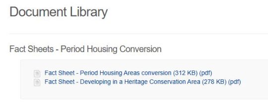
SOURCE: ^https://yoursay.bmcc.nsw.gov.au/periodhousing/widgets/190457/documents
[1] ‘Draft Heritage Data Form – Blue Mountains Heritage 2016‘, 2014, external consultant report on North’s Estate Heritage Conservation Area, Local ID K171, by Paul Davies Heritage Architects Pty Ltd (Sydney), and by Conroy Heritage Planning (Sydney), 11 pages (file size 476KB), ^https://www.bmcc.nsw.gov.au/documents/map-and-heritage-inventory-sheet-k171, a PDF copy embedded and downloadable below.
[2] ‘Heritage Conservation Areas‘, Blue Mountains Council website, 2015, ^https://www.bmcc.nsw.gov.au/heritage/heritage-conservation-areas), 5 pages
[3] ‘DCP 2015 Part D Heritage Management – Guiding the development of heritage properties‘, Revision: Amendment 8, November 2015, Blue Mountains Council, ^https://www.bmcc.nsw.gov.au/documents/dcp-2015-part-d-heritage-management, copy in PDF embedded below for download and printing, 88 pages
[4] ‘Development Control Plan 2015‘, 2015, Blue Mountains Council website, ^https://www.bmcc.nsw.gov.au/development/planning-rules/development-controls-for-land-zoned-under-LEP-2015/DCP-2015, Full Version (916 pages) ^https://www.bmcc.nsw.gov.au/documents/dcp-2015-full-version
[5] ‘Fact Sheet – Period Housing Areas conversion to Heritage Conservation Areas‘, 2018-06-29, Blue Mountains Council website, ^https://yoursay.bmcc.nsw.gov.au/periodhousing/widgets/190457/documents, 2 pages
[6] ‘Fact Sheet – Developing in a Heritage Conservation Area‘, 2018-06-29, Blue Mountains Council website, ^https://yoursay.bmcc.nsw.gov.au/periodhousing/widgets/190457/documents, 2 pages
[7] ‘Blue Mountains Heritage Strategy 2021-2025‘, (undated), by Blue Mountains Council and probably mostly scribed by its external consultant from Sydney, 60 pages, ^https://www.bmcc.nsw.gov.au/advanced-search?keys=The+Blue+Mountains+Heritage+Strategy+2021-2025
Part 1: Strategy Background:
Part 2: Strategy:
Part 3: Implementation Plan:
[ AUTHOR’S NOTE: Hypocrisy in an aloof bubble on steroids – Blue Mountains would do better run from New Zealand.]
[8] ‘blue mountains shed development setback rules neighbours‘, (an Internet web browser search phrase typed by yours truly in ‘Google Chrome’ software), Result per Google AI Overview): See above Part VII above.
[9] ‘Property Map Search‘, Blue Mountains Council’s website, ^https://www.bmcc.nsw.gov.au/property-search
“Search for information about a property:
Use our interactive maps to identify the zoning and site characteristics of land. This property search tool is useful in establishing site constraints and development opportunities.
-
-
- Click on the link below and add the property address.
- Click the ‘layers icon’ in the top right of the webpage, and then tick the maps to view.
- More information is also available by clicking on the three dots to the right of the Lot and Plan number, on the left side of the webpage.
- For the best user experience, please use Google Chrome to browse this website.”
View Our Interactive Maps: ^https://emapping.bmcc.nsw.gov.au/connect/analyst/mobile/#/main?mapcfg=Locality&lang=en-au
[10] ‘State Environmental Planning Policy (Exempt and Complying Development Codes) 2008‘, 2008, NSW Government, ^https://legislation.nsw.gov.au/view/html/inforce/current/epi-2008-0572#sec.2.18
[11] ‘Pictorial Memories – Blue Mountains‘, (book) by John Low OAM, 2ED, 1994, published by Kinsclear Books, 135 pages.
[12] ‘Blue Mountains Council’s ‘love local’ hypocrisy towards small business‘, 2021-05-21, Nature Trail website (click link below)
Blue Mountains Council’s ‘love local’ hypocrisy towards local businesses
[13] ‘ Century-old Blue Mountains kiosk to get new lease of life‘, 2019-04-17, by Alison Cheung, ^https://www.commercialrealestate.com.au/news/century-old-blue-mountains-kiosk-to-get-new-lease-of-life-45705/ [AUTHOR’S NOTE: the terms ‘revitalisation’ and ‘new lease of life’ are anti-heritage architectural values – think Hong Kong high-rise Alison Cheung].
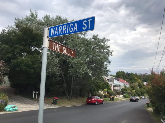 The Gully (Katoomba) holds meaningless heritage value to Blue Mountains Council, except exploitative propaganda and enterprise value to it. No trust.
References and Further Reading:
Blue Mountains {city} Council’s development madness – all “sheds” are auto exempt – so Council: “nothing to see here!”
[This article’s publishing last updated: 11th January 2026.]
Tags: Airbnb invasion of residential, Blue Mountains City Council, Blue Mountains Council, BMCC, council propaganda, exempt development, Greater Blue Mountains World Heritage Area, heritage hypocrisy, housing development, Katoomba, North's Estate, planetary heath con, swimming pool draining to creeks
Posted in 05 Cross Disciplinary Thinking!, 11 Learning Histories!, 19 Reservoir of Management Knowledge!, 28 Heritage Listing Compliance!, 36 Tests of Harm!, 46 Conservation Onground Action!, Blue Mountains (AU), Ph09 Conservation Governance, THE GULLY COLLECTION, Threats from Development, Threats from Government Mismanagement, Threats from Greenwashing, Threats from Groundwater Tampering, Threats from Pollution, Threats from Tourism and Recreation | Comments Off on Blue Mountains ‘City’ Council’s heritage hypocrisy persists
Add this post to Del.icio.us - Digg
Saturday, May 16th, 2020
The Blue Mountains conservation grapevine has alerted Leura locals to a new development threat atop the Jamison Escarpment. It’s seems to be all about facilitating mass tourism and its coming from the custodial land holder itself, the so-called National Parks and Wildlife Service (NPWS).
Trust NPWS?
Apparently, local residents were letterbox dropped on 22nd April 2020 by NPWS. Its Community Information Letter on official NPWS letterhead outlined a project proposal described as the “Gordon Falls Lookout accessibility upgrade“. Accessibility upgrade for whom? Busloads overflowing from nearby congested Echo Point?
It is flagged to be part of some grander “Grand Cliff Top Walk“, and it seems NPWS has already selected a construction contractor, NewScape Designs from inner Sydney.
  The colourful ‘artist’s impression’ of this proposal: it’s not what you know, but who you know in the NSW Government. The colourful ‘artist’s impression’ of this proposal: it’s not what you know, but who you know in the NSW Government.
So why is Gordon Falls Lookout targeted for tourism development?
Well, NPWS’s distributed Community Information Letter to nearby Leura residents reads as follows:
Loading...
So NPWS is calling this tourism development its ‘Gordon Falls Lookout Accessibility Upgrade‘. So it is all about providing disabled access is it?
According to the 2020 sales pitch of NPWS for this tourism infrastructure proposal, it’s apparently just an “upgrade” for Gordon Falls Lookout, not a new development, but this smells of legislative avoidance speak. The entire project is wholly within the Greater Blue Mountains Area, and Sydney Water Catchment, so with such a proposal clearly NPWS are keen to not trigger any sense of ‘development’ (which it obviously is).
The authority behind this Community Information Letter is…
 These public servants are invariable in ‘Acting’ responsibilities akin to casuals. Should they stuff up, then their acting days are immediately over. These public servants are invariable in ‘Acting’ responsibilities akin to casuals. Should they stuff up, then their acting days are immediately over.
The overarching policy and funding is coming out of NSW Premier Gladys Berijiklian‘s tourism infrastructure programme dubbed ‘The Improving Access to National Parks Programme‘. Publicly announced on 9th February 2019, the programme funding is almost $150 million in capital expenditure budgeted to span four years (2019-2023).
“This includes major upgrade works in places like Sydney’s Royal National Park and in the Blue Mountains World Heritage Area, making it easier for people to enjoy our wonderful natural beauty,” Ms Berejiklian said. The funding is to “upgrade” walking tracks, better visitor infrastructure and facilities, etc. Specifically the Gordon Falls Lookout Accessibility Upgrade is part of a masterplan to “upgrade” a 13.6 kilometre Grand Cliff Top Walk from Wentworth Falls to Katoomba in the Blue Mountains World Heritage Area costing $10 million, and “upgrading” access to iconic lookout points to a mobility impaired access standard (another $10 million).
The problem is that the 13.6 kilometre Grand Cliff Top Walk from Wentworth Falls to Katoomba does not exist. Prince Henry Cliff Walk extends from Scenic World to Gordon Falls. But there is no track east of Gordon Falls, not yet anyway, just untouched bushland to Sublime Point to the back of the Fairmont Resort in Leura. So this masterplan is not an upgrade but a new tourism infrastructure development.
Is NPWS Cameron Chaffey tasked with finding a lookout overflow for mass tourism saturated Echo Point? Isn’t Echo Point on local council land? Isn’t the access to Gordon Falls Lookout on local council land as well?
 Three Sisters lookout on a quiet day Three Sisters lookout on a quiet day
So this is the National Parks and Wildlife Service, the delegated official governmental custodians of the Greater Blue Mountains Area?
Has NPWS turned corporate exploitative for the mass tourism visitation buck?
This is test wedge tourism development to broaden the overburdened mass tourism of over-crowded iconic Echo Point to spread the day tripper visitation to multiple eye candy lookouts to suit bus loads of international tourists.
Whose Grandiose Idea is it to rename Prince Henry Cliff Walk?
And why delete the heritage named track Prince Henry Cliff Walk constructed by hand by unemployed men during The Great Depression in 1934? The famous hiking track is seven kilometers long and skirts the northern Jamison Escarpment clifftop track extending from what is now Scenic World on the southern edge of Katoomba to Gordon Falls Reserve on the southern edge of Leura.
The track is undulating and in many sections quite poor, eroded and neglected by the custodial land manager, Blue Mountains Council, to the point of being quite dangerous.
Since the deluge from an East Coasts Low weather event in mid February 2020, the track has been closed due to a number of unrepaired landslips. The entire Leura Cascades area, popular for picnickers and families has been completely off limits to the public for the past four months.
 Prince Henry Cliff Walk heritage walk since 1934 Prince Henry Cliff Walk heritage walk since 1934
Prince Henry Cliff Walk is named in honour of Prince Henry William Frederick Albert, Duke of Gloucester, a son of King George V and Queen Mary. Prince Henry visited Australia and Katoomba by train in 1934. The New South Wales government of the day engaged hundreds of unemployed young men between 1934 and 1936 to construct the track by hand as a means of keeping them gainfully employed and to create a healthy tourist visitation experience for the Blue Mountains. [Source: ^https://sydneyuncovered.com/prince-henry-cliff-walk/]
Prince Henry Cliff Walks is listed on the State Heritage Register as a walking track of historical and aesthetic significance (Item K014).
Then Katoomba local council funded the track, suitable for “comfortable walking for pedestrians of all ages and conditions, linking many of the cardinal attractions of the Jamison Valley escarpment at Leura and Katoomba, is a significant historic token of the efforts to repair the Mountains economy and to serve a public need after the worst of the Depression of the early 1930s. The long track has considerable historic significance at the local level”..and has aesthetic significance at the local level.” [Source: ^https://www.environment.nsw.gov.au/heritageapp/ViewHeritageItemDetails.aspx?ID=1170735].
Realise the Political Background…
Feb 2019: ‘Wentworth Falls to Katoomba – all along the cliff tops’
 Blue Mountains (Labor) MP Trish Doyle, with Leura Bushcare worker and cliff top walk advocate, Norm Harris, near Olympian Rock at Leura. Blue Mountains (Labor) MP Trish Doyle, with Leura Bushcare worker and cliff top walk advocate, Norm Harris, near Olympian Rock at Leura.
In 1982, then chief engineer at Blue Mountains Council, John Metcalfe, had a vision of a walk from Wentworth Falls to the marked tree at Katoomba – all along the cliff tops.
 Map of existing tracks and the missing links for a Wentworth Falls-Katoomba cliff top walk. Map of existing tracks and the missing links for a Wentworth Falls-Katoomba cliff top walk.
Some 20-odd years later, Leura Bushcare worker Norm Harris and his wife, Laurel, took up the cause, convincing the Conservation Society that it would be a “great tourist attraction”. And last week, the NSW Government announced a $10 million grant for an “significant upgrade to the 13.6 kilometre grand cliff top walk”.
Mr Harris was “ecstatic” at the news. “I’m so delighted. I just want them to do it,” he said. The crucial missing links are from the Fairmont Resort around to Sublime Point. But Mr Harris believes a path could be built 60 metres from the rear of properties on Sublime Point Road, which would be invisible to, and not interfere with, the private land owners who live there.
Some years ago he wrote to Waverley Council, asking how it had managed to secure land to complete the Federation Cliff Walk from Watsons Bay to Bondi.
Council replied it had unsuccessfully negotiated with a private land owner but later was able to compulsorily acquire an easement because the land was zoned “regional open space”.
Mr Harris is hoping such an approach may work around Sublime Point Road. He praised the efforts of Blue Mountains MP, Trish Doyle, for raising the issue with then premier, Mike Baird, in 2015, which included sending him detailed maps and concept plans.
“I’ve contacted all the state MPs – Bob Debus, Phil Koperberg, Roza Sage and Trish and Trish is the only one that’s done anything,” Mr Harris said.
Ms Doyle said: “Mr Harris has been plugging away quietly at this proposal for many years, and the announcement of $10 million for stage one of the grand cliff top walk is a testament to his methodical, thorough and expert analysis of the project.
“I am thrilled to have been able to help Mr Harris put forward this proposal and see it come to fruition after four years of making representations to the government on his behalf,” she said.
The premier, Gladys Berejiklian, also announced funding of $9.9 million to upgrade access to iconic lookout points in the Mountains so they comply with mobility impaired access standards.’

[Source: ‘Wentworth Falls to Katoomba – all along the cliff tops ‘, 20190207, by Jennie Curtin, Blue Mountains Gazette newspaper, ^https://www.bluemountainsgazette.com.au/story/5892855/10m-funding-for-cliff-top-walk/]
July 2019: ‘Work begins on $10M grand cliff top walk upgrade’
Work is underway on a major upgrade of national park walking tracks along the cliff tops between Wentworth Falls and Katoomba.
NSW Environment Minister Matt Kean was in the Blue Mountains on Friday to talk with National Parks and Wildlife Service walking track teams carrying out the work, and to visit some of the areas to be upgraded.
 Blue Mountains Councillor Kevin Schreiber (disguised in sunglasses), MLC Shayne Mallard, Environment Minister Matt Kean and the Blue Mountains director of NPWS David Crust, at Govetts Leap Lookout at Blackheath. The carpark at the iconic lookout will be improved, accessible paths added, and the toilets will include disabled access. Blue Mountains Councillor Kevin Schreiber (disguised in sunglasses), MLC Shayne Mallard, Environment Minister Matt Kean and the Blue Mountains director of NPWS David Crust, at Govetts Leap Lookout at Blackheath. The carpark at the iconic lookout will be improved, accessible paths added, and the toilets will include disabled access.
Work has begun in the national park at Wentworth Falls, with the full upgrade expected to take four years to complete.
David Crust, the Blue Mountains director of the NPWS, said they would be adding in a few missing links to walking paths between Wentworth Falls and Katoomba, but mostly they would be improving the quality of existing tracks.
In February the state government announced it would spend $10 million on a “significant upgrade to the 13.6 kilometre grand cliff top walk”. “The changes will include improved walking tracks, better visitor infrastructure and facilities, and upgrading of access to iconic lookout points including mobility impaired access standards,” Mr Kean said.
The grand cliff top walk links a series of existing tracks and is accessible from multiple locations, providing the opportunity for visitors to tailor the length of walk and to create a multi-day itinerary. The walk also provides access to many sidetracks, which offer a variety of experiences and opportunities for all park visitors. Govetts Leap at Blackheath is one of the iconic lookouts in the Mountains set to be upgraded with accessible paths, toilets with disabled access, and improvements to the carpark.
“The investment recognises the importance of the tourism economy in the Blue Mountains and will provide for better and safer visitor experiences across the Blue Mountains National Park,” Mr Kean said.
Work is underway on a major upgrade of national park walking tracks along the cliff tops between Wentworth Falls and Katoomba. NSW Environment Minister Matt Kean was in the Blue Mountains on Friday to talk with National Parks and Wildlife Service walking track teams carrying out the work, and to visit some of the areas to be upgraded.
Councillor Kevin Schreiber, MLC Shayne Mallard, Environment Minister Matt Kean and the Blue Mountains director of NPWS David Crust, at Govetts Leap Lookout at Blackheath. The carpark at the iconic lookout will be improved, accessible paths added, and the toilets will include disabled access.
Work has begun in the national park at Wentworth Falls, with the full upgrade expected to take four years to complete.
David Crust, the Blue Mountains director of the NPWS, said they would be adding in a few missing links to walking paths between Wentworth Falls and Katoomba, but mostly they would be improving the quality of existing tracks.
In February the state government announced it would spend $10 million on a “significant upgrade to the 13.6 kilometre grand cliff top walk”.
“The changes will include improved walking tracks, better visitor infrastructure and facilities, and upgrading of access to iconic lookout points including mobility impaired access standards,” Mr Kean said.
 Young Matt Kean – Gladys patsy to “Kick Start NSW Tourism” by the cruise ship load? Young Matt Kean – Gladys patsy to “Kick Start NSW Tourism” by the cruise ship load?
The grand cliff top walk is a head office branded construct stealing Tasmanian ideas. This late night thought bubble amongst marketing types fueled by taxpayer happy juice, was to link a series of existing tracks and is accessible from multiple locations, providing the opportunity for visitors to tailor the length of walk and to create a multi-day itinerary. The walk also provides access to many sidetracks, which offer a variety of experiences and opportunities for all park visitors. Govetts Leap at Blackheath is one of the iconic lookouts in the Mountains set to be upgraded with accessible paths, toilets with disabled access, and improvements to the carpark.
“The investment recognises the importance of the tourism economy in the Blue Mountains and will provide for better and safer visitor experiences across the Blue Mountains National Park,” Mr Kean said.
[Source: ‘Work begins on $10M grand cliff top walk upgrade’, 20190728, by Ilsa Cunningham, Blue Mountains Gazette newspaper, ^https://www.bluemountainsgazette.com.au/story/6295587/work-begins-on-10m-grand-cliff-top-walk-upgrade/ ]
Rockclimber Michael Connard on his Facebook page ‘Rock Climbing in the Blue Mountains‘ views this project as a “New threat to the Blue Mountains.”
He comments:
“National Parks have just announced the development of a new Grand Clifftop Walk Project – an upgraded walking track stretching from Echo Point to Wentworth Falls. So far National Parks have provided minimal details, but it seems that they are planning to replace at least sections of the existing tracks with raised boardwalks and paving. Part of this redevelopment will be a series of new lookouts including an Echo Point style lookout at Gordon Falls, Leura.
This redevelopment will exacerbate the problems already associated with Echo Point and Wentworth Falls, ie increased visitor numbers, traffic, parking, litter. It will create a new monstrosity at the base of Leura Mall.
Echo Point and Wentworth Falls represent a catastrophic failure of different levels of government to coordinate. The sites are owned by Parks, but council are responsible for parking, traffic management, sewerage & rubbish. Leura simply does not have the capacity to absorb another Echo Point.
This project will cause irreparable harm to Leura and possibly to the clifftop environment. Parks have not released a detailed proposal. They have not released estimates of visitors. There is currently no plan for accommodating tourist buses, toilets, parking or traffic. We would never allow a private developer to undertake such a major project in a national park without releasing detailed plans for public consultation. We shouldn’t allow Parks to do it either.
National Parks are requesting comments regarding this proposal but are proposing to commence construction in June 2020. This is not a genuine public consultation process. If anyone can put me in touch with Wentworth Falls and Katoomba people who are grappling with the impacts of the Echo Point and Wentworth Falls lookouts I would greatly appreciate it.”
[Source: ^https://m.facebook.com/groups/rcibm/permalink/1352591044928657/]
So what does NPWS stand for?
Now for starters, the National Parks and Wildlife Service (NPWS) is not national. It’s a misnomer. The NPWS is a New South Wales Government department; actually it is not even that. It has been reduced to being a sub-department within a department, having had years of funding cuts and staff mass sackings. Since 2009, restructure after restructure has meant 50% fewer rangers since 2009, deliberate dumbing down of rangers to non-graduate classifications and junior roles, with dozens of scientists, ecologists and specialists having been made redundant. In 2016 and 2017, 27% ($121 million) was pulled out of the NPWS budget according to Labor’s opposition then environment spokesperson Penny Sharpe with 500 full time positions lost since 2011.
NPWS is just like Parks Victoria across the southern border. It is a state agency headquartered in Hurstville in southern Sydney, not in Canberra. Even the headquarters is a shell..
 [Source: ^https://www.environment.nsw.gov.au/contact/Hurstville.htm] [Source: ^https://www.environment.nsw.gov.au/contact/Hurstville.htm]
It has been swallowed up under what is currently called The Environment, Energy and Science (EES) Group, a corporatised body within the Department of Planning, Industry and Environment (NSW).
It is a shadow of its former self from the halcyon optimistic days under conservationist Premier Bob Carr between 1995 to 2005, when 100 national parks were rolled out between Nowra and the Bega Valley, and when the Greater Blue Mountains Area received world heritage recognition by UNESCO in Geneva. In New South Wales, there is no Department of Environment, and the Office of Environment and Heritage (OEH) is gone.
And NPWS is not a service for wildlife. The recent Summer 2019-20 bushfire emergency that engulfed the Greater Blue Mountains Area is a testament to that. Three small remote ignitions were allowed to burn away – one in the Wollemi National Park, one in the Kanangra Boyd National Park and one in the Blue Mountains National Park. They were dubbed respectively the Gospers Mountain Fire, the Green Wattle Creek Fire and the Ruined Castle Fire. NPWS allowed some 80% of the Greater Blue Mountains Area wilderness and native habitat to be incinerated causing wildlife extinctions throughout the region. Across the state, more than five million hectares of mainly natural bushland was allowed to go up in smoke, most of it under the custodial responsibility of the NPWS.
According to ecologist Professor Chris Dickman from the University of Sydney, over a billion fauna and “hundreds of billions” of insects have been killed in bushfires throughout New South Wales over the summer season.
“For some species we’re looking at imminent extinction. There will almost certainly be species of all geographical ranges and populations that are cooked before we’ve even had the chance to discover that they exist.”
Professor Dickman said the aftermath may mean “species that are rendered extinct, ecosystems that have been eroded to the point where they are completely changed, and habitat in a state of widespread impoverishment. The loss of life we’ve estimated for NSW is 800 million terrestrial animals, including birds and reptiles. But that figure doesn’t include frogs, fish, bats and invertebrates,” he said. “Combining these figures [it] is likely well over a billion animals lost.”
[Source: ‘NSW bushfires lead to deaths of over a billion animals and ‘hundreds of billions’ of insects, experts say‘, 20200109, by Emma Elsworthy, ABC, ^https://www.abc.net.au/news/2020-01-09/nsw-bushfires-kill-over-a-billion-animals-experts-say/11854836].
 Australia’s iconic Koala – officially fast-tracked towards being categorised as ‘Extinct in the Wild’. Australia’s iconic Koala – officially fast-tracked towards being categorised as ‘Extinct in the Wild’.
NPWS is really a tourist park service. It’s brief is less about wildlife conservation and more about economic cost recovery.
Further Reading:
[1] ‘ A New National Park for NSW‘, 20190204, media release by NSW Premier Gladys Berejiklian, ^ https://www.nsw.gov.au/media-releases/a-new-national-park-for-nsw. Read below:
‘Premier Gladys Berejiklian has today announced a new national park for NSW – providing another significant boost for the State’s koala population – along with a major new package that will improve access to existing national parks.
The State’s newest national park will cover around 3680 hectares in the north of Goulburn electorate, bordering Wollondilly. The new park is centered around Tugalong Station – about 25 kilometres northwest of Bowral.
“The NSW Liberals & Nationals have been careful custodians of the State’s national parks and I am thrilled to be able to unveil a new one today,” Ms Berejiklian said.
“This new national park will ensure that a vital koala wilderness area south of Sydney is preserved. Like all national parks, it will be open to the public so they can explore the wilderness country.”
Ms Berejiklian also announced a $150 million investment to improve access to national parks across NSW – funding made possible due to the strong economic management of the NSW Liberals & Nationals.
“This includes major upgrade works in places like Sydney’s Royal National Park and in the Blue Mountains World Heritage Area, making it easier for people to enjoy our wonderful natural beauty,” Ms Berejiklian said.
Environment Minister Gabrielle Upton said the new national park contains some of the Southern Highlands’ best koala habitat.
“Koalas are an iconic species and we are acting to ensure their survival,” Ms Upton said.
“The new national park will not only add to the State’s conservation lands, it is yet another example of how the NSW Government is moving to protect and preserve the koala population.”
The Government’s $150 million investment to improve access to existing national parks includes upgraded walking tracks, better visitor infrastructure and facilities and new digital tools such as virtual tours and livestreaming cameras.
This will include:
-
- More access – significant upgrade to the 13.6 kilometre Grand Cliff Top Walk from Wentworth Falls to Katoomba in the Blue Mountains World Heritage Area ($10 million). Also, upgrading access to iconic lookout points to a mobility impaired access standard ($9.9 million);
- Improved park visitor infrastructure and facilities – expansion of picnic areas, BBQs, water provision, facilities ($38.7 million) and increased support for families and people with restricted mobility ($45 million). This will include upgraded picnic facilities and the walking tracks at Audley Weir, in the Royal National Park.
- Safe access – Investment in making our extensive network of walking tracks and trails safer and more accessible ($36.4 million); expansion of the ‘Think before you Trek’ safety program for bushwalkers and work with other agencies to deliver other priority safety programs like rock fishing and enhanced mobile connectivity in the parks ($1 million).
“NSW boasts some of the most majestic and picturesque coastal lookouts, outback walking tracks, camping grounds and beaches in the world and we want more visitors to experience the natural beauty and wonder of our national parks,” Ms Berejiklian said.
Ms Upton added:“As well as international and interstate tourists, we want to make it easier for families to get out there and discover the natural beauty our State.”
[2] ‘Under siege: our commitment to Australia’s national parks is waning‘, 20181218, by Anne Davies, The Guardian (newspaper), ^https://www.theguardian.com/environment/2018/dec/17/under-siege-our-commitment-to-australias-national-parks-is-waning.
[3] ‘Wentworth Falls to Katoomba – all along the cliff tops ‘, 20190207, by Jennie Curtin, Blue Mountains Gazette newspaper, ^https://www.bluemountainsgazette.com.au/story/5892855/10m-funding-for-cliff-top-walk/]
[4] ‘Work begins on $10M grand cliff top walk upgrade‘, 20190728, by Ilsa Cunningham, Blue Mountains Gazette newspaper, ^https://www.bluemountainsgazette.com.au/story/6295587/work-begins-on-10m-grand-cliff-top-walk-upgrade/
[5] ‘K014 : Prince Henry Cliff Walk‘, (state heritage listed item), NSW Department of Planning, Industry and Environment (NSW Government website), ^https://www.environment.nsw.gov.au/heritageapp/ViewHeritageItemDetails.aspx?ID=1170735
[6] ‘Sydney Uncovered‘ (tourist website), ^https://sydneyuncovered.com/prince-henry-cliff-walk/
[7] ‘Leaked Documents Uncover Massive Gaps In National Parks Positions‘, 20191122, in The Beagle Weekly, Eurobodalla Shire NSW, ^https://www.beagleweekly.com.au/post/leaked-documents-uncover-massive-gaps-in-national-parks-positions
[8] Park Watch – Defending our National Parks (conservation website), ^https://parkwatchnsw.org/
Tags: Blue Mountains, Blue Mountains Councillor Kevin Schreiber, Gordon Falls Lookout, Grand Cliff Top Walk, Jamison Valley, John Metcalfe, Labor MP Trish Doyle, Leura, mass tourism, MLC Shayne Mallard, NewScape Design, Norm Harris, NPWS, NPWS Director David Crust, Premier Gladys Berijiklian, Prince Henry Cliff Walk, Professor Chris Dickman, Three Sisters
Posted in Blue Mountains (AU), Threats from Tourism and Recreation | Comments Off on Gordon Falls Lookout Development for whom?
Add this post to Del.icio.us - Digg
Saturday, November 15th, 2014
 Smoking Ceremony or Smoke and Mirrors?
Staged for the delegates by National Parks and Wildlife Service of New South Wales (NPWS), somewhere outside Sydney, Australia
[Source: ‘Global First Nations environmentalists share stories at the World Parks Congress in Sydney.5:30’, ^https://twitter.com/nitvnews, 20141113] Smoking Ceremony or Smoke and Mirrors?
Staged for the delegates by National Parks and Wildlife Service of New South Wales (NPWS), somewhere outside Sydney, Australia
[Source: ‘Global First Nations environmentalists share stories at the World Parks Congress in Sydney.5:30’, ^https://twitter.com/nitvnews, 20141113]
.
Every ten years a World Parks Congress is a forum staged by the International Union for Conservation of Nature to discuss the effectiveness of World Heritage Listed Protected Areas. For 2014, Parks Australia put up Sydney’s hand to host and fund it.
<<“We (Parks Australia) are delighted to be co-hosting the IUCN World Parks Congress with our colleagues in the New South Wales National Parks and Wildlife Service – and look forward to welcoming inspiring leaders from around the world.”>>
IUCN’s vision is a “just world that values and conserves nature.” The theme for the 2014 conference is “Parks, people, planet: inspiring solutions”.
The last congress was in Durban, South Africa eleven years ago in 2003 and significant messages from that congress were that:
- Considerable progress has been made in the establishment of protected areas although significant gaps remain
- Protected areas face many challenges, and management effectiveness must be strengthened
- Protected areas play a vital role in biodiversity conservation and sustainable development
- A new deal is needed for protected areas, local communities and indigenous peoples
- There is a need to apply new and innovative approaches for protected areas, linked to broader agendas
- Protected areas require a significant boost in financial investment
- Protected areas management must involve young people
.
Congress Cost Benefits ?
.
The obvious first question for the 2014 Sydney Congress is what are the outcomes from these seven messages of 2003?
The second question is what is to be the conservation return on investment of staging the 2014 congress in Sydney? That starts with Parks Australia and NPWS disclosing the full costs of the congress. How much will it have cost by the time this week is over? Five million? Ten million? Twenty million? More? That also involves disclosure of the onground conservation outcomes, if any. The congress hosts more than 5000 delegates for a week-long event in Sydney.
If the answers are not forthcoming and/or the performances less than satisfactory, then perhaps the money could have been better spent (invested) by Parks Australia and NPWS on specific onground conservation of current and worthy Protected Areas in Australia. So the third question is what is the opportunity cost of the 2014 IUCN World Parks Congress which could have delivered the IUCN vision of a “just world that values and conserves nature”?
.
Congress Opportunity Costs
.
According to IUCN director general, Julia Marton-Lefevre, assessments during the past decade have found that half of the world’s protected areas at best — and possibly as few as 20 per cent — are managed effectively. “Some are what we refer to as ‘paper parks’ ” – parks just on paper.
The Australian Government’s $180 million allocation to expand the park reserve system expired last year.
The Great Barrier Reef Marine Park is a case in point. It is the iconic Protected Area in Australia. Its World Heritage listing along with various national zoning, management plans, permits, education and incentives are supposed to protect and conserve the marine ecosystems and migratory species from human threats. But farm and urban runoff continues to contaminate the rivers that flow into the Reef.
In 2009 and 2011, mining company Queensland Nickel discharged nitrogen-laden water and 516 tonnes of toxic waste water into the Great Barrier Reef.
On 21 July 2013, on the second day of the biennial joint training exercise Talisman Saber, two American AV-8B Harrier fighter jets launched from aircraft carrier USS Bonhomme Richard (LHD-6) dropped four bombs, weighing a total 1.8 metric tons (4,000 pounds), into more than 50 metres (164 ft) of water. On 3rd April 2010, The Shen Neng 1, a Chinese ship carrying 950 tonnes of oil, ran aground, causing the 2010 Great Barrier Reef oil spill.
In December 2013, Greg Hunt, the Australian environment minister, approved a plan for dredging to create three shipping terminals as part of the expansion of an existing coal port. According to corresponding approval documents, the process will create around 3 million cubic metres of dredged seabed that will be dumped within the Great Barrier Reef Marine Park.
On 31 January 2014, a permit was issued to allow three million cubic metres of sea bed from Abbot Point, north of Bowen, to be transported and unloaded in the waters of the Great Barrier Reef Marine Park, just outside of Abbot Bay. The dredge spoil will cloud the water and block sunlight, thereby starving sea grass and coral up to distances of 80 km away from the point of origin due to the actions of wind and currents. The dredge spoil will smother reef or sea grass to death, while storms can repeatedly resuspend these particles so that the harm caused is ongoing; secondly, disturbed sea floor can release toxic substances into the Great Barrier Reef Marine Park.
 Dredging the Great Barrier Reef for bulk export shipping Dredging the Great Barrier Reef for bulk export shipping
.
The Great Barrier Reef Marine Park has become just a blue line on a map. The trickle of funds for Australia’s national parks betrays a lack of appreciation of their economic contribution. Annual funding for the authority that runs Australia’s most famous reserve, the Great Barrier Reef Marine Park, is about 1 per cent of the $5.2bn it earns the country in tourism revenue.
Yet if the IUCN World Parks Congress cost a conservative $20 million to stage then a key opportunity cost would be the June 2014 Federal budget cuts to the Great Barrier Reef Marine Park Authority.
The budget axed 17 staff including five of its’ directors positions. These positions included the director of heritage conservation, the director of policy and governance and the director of coastal ecosystems and water quality as part of an internal restructure. It’s being described as the greatest loss of expertise from Australia’s most important natural wonder and it comes at the very time the Great Barrier Reef is facing the greatest threat to its survival.
The Greater Barrier Reef Marine Park Authority has been reduced by the Australian Government to being in name only and ineffective at protecting the reef.
Until recently, one of those five directors, Adam Smith, was charged with dealing with the contentious Abbot Point coal terminal development and the proposal to dump three million cubic metres of dredge spoil into the marine park. Despite Dr Smith’s concerns, the sea dumping was approved by the Marine Park Authority.
Dr Smith has since accepted voluntary redundancy and moved on after disagreeing with the Authority’s new economic leadership and values. Heritage conservation director Jon Day has left after 21 years, disillusioned too with the direction the Authority has taken to compromise the reef.
Next year UNESCO will decide whether to put the reef on its world heritage in danger list. Native Dugongs are already endangered. The deliberate extermination of the dugong and turtles which habituated the Gladstone area is a national tragedy. Dugongs are species listed under the Federal Environment Protection Biodiversity & Conservation Act, which requires the Federal government to legally protect these animals.
Prior to the massive dredging operation of 52 million cubic metres of seabed for the development of the world’s largest LNG Terminal, ( which is 62% completed) a study commissioned by the Gladstone Ports Corporation found that a take, or a quota, of more than zero dugongs would be unsustainable.
In the face of massive mortality of dugongs, turtles and inshore dolphins during the ongoing massive dredging, both the Federal and Queensland governments ignored the slaughter.
Look at the stranding data from the Queensland Department of Environment and Resource Management. Monthly cumulative Dugong strandings by year for Queensland, up to 31 January 2012.
There are 22,000 vessel movements a month in Gladstone Harbour. No ship strikes of Dugongs or of Green Turtles need to be reported. No audit of environmental conditions has been undertaken by the Queensland or Federal Governments. The wholesale slaughter of our marine wildlife is the price Australians are paying for the transformation of the Great Barrier Reef World Heritage Area into the world’s largest unregulated quarry.
 Mass tourism operators good for the economy
Getting up close to protected Humpback Whales within their 100 metre Protected Area Mass tourism operators good for the economy
Getting up close to protected Humpback Whales within their 100 metre Protected Area
.
Australian protected areas have seen rule changes in the eastern states have allowed cattle to graze, recreational shooters to hunt and hotel developers to build in national parks. Shore-based recreational fishing has been allowed in areas of NSW marine parks previously zoned as no-take sanctuaries. National parks on land and in the ocean are dying a death of a thousand cuts, in the form of bullets, hooks, hotels, logging concessions and grazing licences.
Yet as host of the 2014 World Parks Congress, Australia is showcasing “our own inspiring places, inspiring people and inspiring solutions.” The Global Eco Forum within the Congress programme focuses on tourism exploitation of Protected Areas because like the new Greater Barrier Reef Marine Park Authority, the new values are not about conservation by the billions in revenue opportunity to Australia’s economy.
The October 2006 issue of National Geographic published an article “The Future of Parks: Hallowed Ground – Nothing is Ever Safe”.
It stated:
“Landscape and memory combine to tell us certain places are special, sanctified by their extraordinary natural merits and by social consensus.
We call those places parks, and we take them for granted.”
.
Sydney’s 2014 World Parks Congress appears to be expensive window dressing, showcasing fraudulent conservation of Protected Areas in Australia.
It’s termed Greenwashing. The opportunity cost of the 2014 Congress could have instead funded the retention of the previously effective Great Barrier Reef Marine Park Authority and so done more for Protected Areas than all the pomp, promising, luncheons, showcasing, and talk-festing of the congress combined.
.
 Protest to stop Queensland Resources Council dumping dredge spoil inside the Reef
Protest by Cairns and Far North Environment Centre (CAFNEC), June 2014
^http://cafnec.org.au/wp-content/uploads/2014/03/rally-promo-photo.jpg Protest to stop Queensland Resources Council dumping dredge spoil inside the Reef
Protest by Cairns and Far North Environment Centre (CAFNEC), June 2014
^http://cafnec.org.au/wp-content/uploads/2014/03/rally-promo-photo.jpg
.
Further Reading:
.
[1] IUCN World Parks Congress (Sydney 2014), International Union for Conservation of Nature, ^http://worldparkscongress.org/
.
[2] ‘Global Eco-Tourism in Protected Areas‘, by EcoTourism Australia, >2014 Global Eco Tourism in Protected Areas.pdf (1.1MB, 2 pages)
.
[3] Great Barrier Reef Marine Park Authority (website), Australian Government, ^http://www.gbrmpa.gov.au/
.
[4] Fight for The Reef (website), Australian Marine Conservation Society, ^https://fightforthereef.org.au/risks/dredging/
.
[5] No Hunting in National Parks (website), The National Parks Association of NSW, ^http://nohunting.wildwalks.com/
.
[6] ‘An international perspective on tourism in national parks and protected areas‘, by J.G. Castley (2014), >An international perspective on tourism in national parks and protected areas.pdf (100kb, 10 pages)
.
[7] ‘EXTRA: ‘Nasho’, Royal National Park, Sydney’s neglected southern jewel‘, by Nick Galvin, Journalist, Sydney Morning Herald, 20140613, ^http://www.smh.com.au/nsw/extra-nasho-royal-national-park-sydneys-neglected-southern-jewel-20140613-zs6d8.html
.
[8] ‘Paradise lost: Australia’s heritage jewels under threat‘, (audio), ABC ‘Background Briefing’ radio programme, by Sarah Dingle, 20131208, ^http://www.abc.net.au/radionational/programs/backgroundbriefing/2013-12-08/5132224
.
 White Lemuroid Possum
(Wet Tropics of Queensland World Heritage Area in Danger)
Has the white lemuroid possum become the first mammal to go extinct due to global warming? White Lemuroid Possum
(Wet Tropics of Queensland World Heritage Area in Danger)
Has the white lemuroid possum become the first mammal to go extinct due to global warming?
The species, normally found above 1000m, has not been sighted during any nighttime spotlighting expedition since 2005. Experts fear a temperature rise of 0.8 degrees Celsius may be to blame for the animal’s disappearance.
[Source: ^http://www.wherelightmeetsdark.com/index.php?module=newswatch&NW_user_op=view&NW_id=453]
.
Tags: Dugong, Dugong strandings, Gladstone Harbour, Great Barrier Reef, Great Barrier Reef Marine Park, Green Turtle strandings, greenwashing, Humpback Whale, International Union for Conservation of Nature, iucn, national parks, National Parks and Wildlife Service, Parks Australia, Protected Areas in Australia, Queensland Government, The Great Barrier Reef Marine Park Authority, UNESCO world heritage in danger list, Wet Tropics of Queensland World Heritage Area in Danger, White Lemuroid Possum, World Heritage, World Parks Congress
Posted in Critically Endangered Wildlife (CR), Threats from Government Funding Neglect, Threats from Greenwashing, Threats from Pollution, Threats from Tourism and Recreation, Threats from Weak Environmental Laws | No Comments »
Add this post to Del.icio.us - Digg
Friday, September 20th, 2013

Last Monday 20130916, around 8.30am a native dingo was hit by a vehicle at 18 Mile Beach between Eurong and Dilli Village on Fraser Island. The Island is a World Heritage listed National Park and the wildlife is protected under the Nature Conservation Act.
Distressed witnesses stated the vehicle deliberately changed direction and aimed for the dingo which was struck. The vehicle continued to proceed at speed along the beach. It was described as an Orange Pajero.
The female lay suffering and howling in the sand with her mate close by licking her wounds, a Police Officer was called, who in turn contacted Rangers, sadly, the dingo had to be euthanised.
She appeared to be feeding. The fate of her pups is unknown.
This senseless act of cruelty will hardly cause a stir, there needs to be much stiffer penalties for injuring our wildlife. This is not acceptable.
The School holidays are here, a dingo casualty now, a child could be next.
If anyone has information please contact the local police or QPWS on (07) 4121 1800
Cheryl Bryant. Publicity Officer. Save Fraser Island Dingoes Inc.
 This is an old model Pajero, which may look like the killer’s car
.
[Ed: It is past time that Fraser Island was completely closed to all tourism]
.
Saturday, August 17th, 2013
 Eastern Water Dragon
(Physignathus lesueurii)
Taken for the benefit of the photograph, not the dragon
Photo by Editor in Blue Mountains, Australia, 20061112, photo © under ^Creative Commons]
Click image to enlarge Eastern Water Dragon
(Physignathus lesueurii)
Taken for the benefit of the photograph, not the dragon
Photo by Editor in Blue Mountains, Australia, 20061112, photo © under ^Creative Commons]
Click image to enlarge
.
Wildlife photography is not about humanising wildlife for entertainment. It ought to be about awareness, wonder and respect for wildlife and their habitat.
Zoology may be about technical understanding of the structure and classification of the animal kingdom, but since Darwin we have realised that animals are so much more complex creatures of behaviour and integral to ecology than just being taxidermied museum specimens for public display.
Zoos are just an extension of museums for the benefit of public entertainment. But they do not respect wildlife in their habitat.
 [Source: ^http://katialglobal2viceduau.global2.vic.edu.au/personal-learning/]
.
In their habitat and ecological context, photographed wildlife may be better appreciated and valued for their integral role in Nature. But at a respectful distance.
.
 Not for the camera, but naturally obscured in its habitat
A more interpretative photo, but still too close.
Photo by Editor 20061112, photo © under ^Creative Commons] Not for the camera, but naturally obscured in its habitat
A more interpretative photo, but still too close.
Photo by Editor 20061112, photo © under ^Creative Commons]
.
“The two basic processes of education are knowing and valuing”
~ Robert J. Havighurst (1900-1991).
.
.
.
Empathy for Other Species is the Key to Ethical Wildlife Photography
.
[Source: “Empathy for Other Species is the Key to Ethical Wildlife Photography”, by Jim Robertson, ^http://www.wildwatch.org/Binocular/bino01/empathy.html]
.
<< A deep admiration for Nature has led many to another level of appreciation–the craft of wildlife photography.
Unfortunately, not all who photograph wildlife do so out of caring and with respect for our fellow beings. In fact, the behavior of many photographers, both amateur and professional, can only be described as disrespectful, disruptive and sometimes dangerous to the animals they are photographing.
For example, every spring in Yellowstone you are sure to see a large group of photographers standing around–or even sitting on lawn chairs–talking loudly right outside some poor badger’s birthing den, waiting for the family to emerge. Though these folks may think nothing of the clamor of a rowdy bar or ball game, how would they like to live next door to that bar or ball field, or wake up to the racket of an expectant crowd of photojournalists right outside their bedroom window?
In response to this kind of ill-behavior, which invariably results in the harassment or endangerment of wildlife, informal guidelines have been established to spell out just how close, in yards or feet, one should get to an individual animal, depending on that species’ tolerance zone.
 Badger Den
This mother and young badger were photographed across the road from their den using a 600mm telephoto lens and a 2X multiplier
Photo © Jim Robertson
^http://www.wildwatch.org/Binocular/bino01/empathy.html] Badger Den
This mother and young badger were photographed across the road from their den using a 600mm telephoto lens and a 2X multiplier
Photo © Jim Robertson
^http://www.wildwatch.org/Binocular/bino01/empathy.html]
.
But rather than memorizing numbers and gauging distances, perhaps it would be easier for photographers and wildlife observers to apply The Golden Rule in each and every situation.
However, instead of the old, oversimplified rule, “Do unto others as you would have them do unto you,” why not adopt a revised golden rule that takes into account the differences between ourselves and other species? Maybe something like, “Do unto others as you think they would have you do unto them.” In other words, try to envision what the animals’ needs and self interests are and take into consideration how their lives in the wild are different from our own.
Empathy, the intellectual or emotional identification with another — or the ability to relate to others — is essential for maintaining ethical standards when photographing wildlife.
Last spring I watched from a distance as the annual gathering of noisy photographers was posted outside the entrance of a badger den. They were so deep in conversation and oblivious to their surroundings that none of them noticed as the mother badger finally made a break for it in hopes of procuring food for her young.
The day before, I had photographed the same badger den from across a road with a 600mm telephoto lens fitted with a 2X extender to bring the subject in closer without actually getting close. Because I remained on the opposite side of the road and well away from the den, quietly giving them the space they needed to engage in their activities and enjoy the sunny day, the badger and her young came and went freely, without paying me any notice.
.
The Poor Man’s Super-Telephoto Lens:
.
 . .
<< The lens of choice among the serious pro wildlife photographers I know seems to be the 600mm ƒ/4 super-telephoto. It’s great for subjects that won’t let you get close, is incredibly sharp, and autofocuses quickly and accurately. However, it costs over $7,000.
That being just a bit beyond my budget, when I really need “reach,” I turn my $1,200 300mm ƒ/4 lens into a 600mm ƒ/8 by attaching a $300 2x teleconverter between the lens and camera body.Also known as tele-extenders, teleconverters are available from the major lens manufacturers for their long lenses, and offer three major benefits.
First, as just cited, they’re an economical way to get superlong focal lengths. And they’re not just for the budget-challenged. Pros use them, too—a 1.4x converter turns that monster 600mm into an 840mm; a 2x converter, into a 1200mm.
The second benefit of the teleconverter is that it doesn’t change the lens’ minimum focusing distance. Add a 2x converter to a 300mm lens that focuses down to five feet, and you have a 600mm lens that focuses down to five feet. (For comparison, my camera manufacturer’s 600mm super-telephoto won’t focus closer than 18 feet unless you attach it to an extension tube; but then it won’t focus out to infinity.)
The third teleconverter benefit is lack of bulk. A 300mm lens with a 2x teleconverter is much more compact than a 600mm ƒ/4 super-telephoto lens. (A 600mm ƒ/8 prime lens also would be smaller than the 600mm ƒ/4, but currently no one makes a 600mm ƒ/8. >>
[Source: ‘The Poor Man’s Super-Telephoto’, 20090421, by Mike Stensvold, ^http://www.outdoorphotographer.com/gear/lenses/the-poor-mans-super-telephoto.html]
.
A national Park like Yellowstone can be the perfect place for photographing animals without causing them undue stress. Since they know they are safe from hunting within park boundaries, “game species” are not so distrustful of human presence.
Although many species are easily viewable from park roadways, they are much less concerned about vehicles than people approaching on foot. Staying in your car makes wildlife feel more comfortable, and your vehicle makes a great blind for photographing animals calmly going about their business. Some of my best photos have been taken out of the window of my rig.
Other examples of photographer misconduct include trimming away vegetation–that may conceal a nest or den from people and predators–to get a clearer photo, throwing food to attract animals, and the all-too-common habit of yelling or honking at an elk, a bison or a family of bears so they will look toward the camera.
By using empathy we can begin to recognize changes in behavior and respect the signals animals use to convey to us that we are irritating them or getting too close for their comfort.
Every year irresponsible photographers are gored by bison, trampled by moose, or charged by bears. When these animals are annoyed to the point that they feel the need to defend themselves, chances are they will suffer or die for it in the end. Thoughtless conduct can also force animals to leave their familiar surroundings, interrupt natural activities necessary for survival, or even separate mothers from their young.
.
 Bull Elk
This bull elk was photographed from my vehicle in Jasper National Park, Alberta, using a telephoto lens
Photo © Jim Robertson, ^http://www.wildwatch.org/Binocular/bino01/empathy.html] Bull Elk
This bull elk was photographed from my vehicle in Jasper National Park, Alberta, using a telephoto lens
Photo © Jim Robertson, ^http://www.wildwatch.org/Binocular/bino01/empathy.html]
.
Outdoor Photographer magazine ran an article in January/February 2000 on “Tips for Photographing Eagles” with the sub-heading “A long lens, the right location and a sensitive approach can get you excellent images of these majestic birds”.
The author of the article, Bill Silliker, Jr. wrote, “If you don’t have a long lens, don’t push it. Ethical wildlife photography requires that we forego attempts to photograph wildlife when we’re not equipped for it or if the attempt might harass or somehow place the subject in jeopardy. Be satisfied with images that show an eagle in its habitat. Editors use those too.”
The other day a neighbour stopped by and, upon seeing the small herd of black-tailed deer who found refuge on my land, asked if I was a hunter. When I said, “No, I’m a wildlife photographer,” he shrugged and replied, “It’s all shooting.”
Well, yes and no.
The obvious, major difference is that the animals “shot” with a camera do not end up dead. But because there are similarities to hunting, many people approach wildlife photography with a similar mind-set. It’s laughable to see photographers in a national park camouflaged from head-to-toe, sometimes including face paint, photographing a bull elk as he calmly grazes alongside the road–fully aware of their presence. And I couldn’t count how many times I’ve seen tourists run right up to a bear, elk, bison, or moose with a tiny disposable camera to get their close-up “trophy” photo.
They seem to think it’s only fair–that they are entitled to get closer–since they don’t have a large telephoto for their camera. But if they were to examine their motives they would realize that their behaviour is not fair to the animal. Is their trophy more important than the well-being of the subject of their photo?
At the height of disregard, some photographers will use hounds fitted with radio collars to pursue and corner bears, bobcats, or cougars for close-up photos of these more elusive species. If they are “lucky”, they might even catch the animal snarling in response–just the way any number of hunting magazines like to portray them on their covers or in juicy, two-page fold-outs. But how would they feel if they had to flee for their lives, chased down by a pack of dogs until they were exhausted or treed, just so someone could get a picture of them?
Wildlife photography should not be thought of as a sport or challenge against nature, or against the animals who did not volunteer for the game. Would it be considered ethical to make sport of photographing unwilling human subjects?
Unethical practices of those who photograph wildlife for self-serving purposes have given the whole field a bad name. Bill McKibben, author of “The End of Nature” has proposed a moratorium on new wildlife photos, to prevent further aggravation of endangered animals. He argues there are plenty of photos already out there for use in prints and publications. As more incidents of unethical behaviour by photographers occur, the privilege of photographing wild animals will become more and more restricted.
Still, no amount of harassment or disruption of wildlife in any way justifies the increasingly popular use of game farms by so-called wildlife photographers.
Too often, the “wild” animal seen in a publication or promotional is actually a captive animal sentenced to life on a game farm. Game farms use high fences, costing upwards of $8,000.00 per mile, to keep their preferred, sometimes exotic species in. These fences also effectively keep the native migratory wildlife out, thereby taking up valuable habitat.
While many game farms profit directly from the hunting of animals in their enclosures, others appear relatively innocuous, charging only for public viewing and private photographic sessions with “wildlife models,” including crowd-pleasing kittens, cubs, or fawns bred specifically for that purpose. But as these animals get older and less photogenic, they are auctioned off as “surplus” to the highest bidders–a common practice of zoos as well. It is likely the same animals that appeared as cute babies on calendars, greeting cards, or other publications will end up a few years later at another game farm that does profit from the canned hunting of them.
.
 Grizzly Bear Grizzly Bear
This sow grizzly bear was photographed with a 600mm telephoto
from a supervised Forest Service observation platform along Fish Creek, in Southeast Alaska.
Photo © Jim Robertson
^http://www.wildwatch.org/Binocular/bino01/empathy.html]
.
Most photographers and photo editors do not differentiate between wild or captive animals when selling and publishing images. Using photos shot at game farms supports those who profit from exploiting animals by keeping them captive to serve as models for photographers, entertainment for tourists, or targets for trophy hunters. At the same time, these photos set a new, unnatural standard for closeness and intimacy with animals that the public expects to see in every future image.
And while on the subject of ethics, how ethical is it to top off a day of photographing waterfowl or ungulates with a dinner of poultry or red meat?
.
Don’t all living beings deserve our compassion and respect?
.
I had long heard that animals feel less threatened by someone who does not eat meat, but I wondered how long a human could survive without consuming the flesh of others. After six years as a vegan, I can attest to the fact that wild animals are not as fearful of me now, and that saying “no” to animal protein is healthier and easier than I ever would have imagined. >>
.
Wednesday, July 24th, 2013
 Jaguars fight – set up to entertain “ecotourists”
‘Reality Zoos’ ?
[Source: ^http://www.ironammonite.com/2011/11/ecotourism-or-ecoterrorism-big-cats.html] Jaguars fight – set up to entertain “ecotourists”
‘Reality Zoos’ ?
[Source: ^http://www.ironammonite.com/2011/11/ecotourism-or-ecoterrorism-big-cats.html]
.
In 1999, Canadian David A. Fennell, PhD, based at Brock University in Ontario in the Department of Recreation and Leisure Studies wrote a poignant text about the ‘ecotourism’ phenomenon. We recommend its read, now in its third edition from 2007. We extract a small portion from the second edition as an article below.
[Text: ‘Ecotourism: an introduction’, 2003, 3e, book by David A. Fennell, published by Routledge (imprint of Taylor and Francis Group), New York, America, ISBN 0-415-30365-6, Dewey Code: 338.4791-dc21]
 Third Edition (2007)
^http://www.nhbs.com/ecotourism_tefno_87800.html Third Edition (2007)
^http://www.nhbs.com/ecotourism_tefno_87800.html
.
<< As arguably the largest and fastest growing industry, the potential impacts of tourism are considerable.
Devised by social and natural scientists, ‘ecotourism‘ can be an effective way to safeguard local communities and prevent the destruction of the natural world.
Responding to increased interest and global competition, the tourist industry has not been slow to appropriate the term to describe a host of different experiences, maredly different from its origins. (Fennell identifies) “inconsistencies in the philosophical basis of ecotourism, and the development and implementation of ecotourism products in a variety of destinations.
For example, in a sobering account of her travel experience in the Peruvian rainforest, Arlen (1995) writes that ecotourism has reached a critical juncture in its evolution. She speaks graphically of instances where tourists endured swimming in water with human waste; guides capturing Sloths and Caiman for tourists to photograph; raw sewage openly dumped into the ocean; mother Cheetahs killing their cubs to avoid the harassment of Cheetah-chasing tourists; and an ecotourism industry under-regulated with little hope for enforcement.
Similar experiences have been recorded by other writers including Farquharson (1992), who argues that ecotourism is a dream that has been severely diluted. She writes that whereas birding once prevailed, ecotourism has fallen into the clutches of many of the mega-resorts like Cancún: the word (ecotourism) changes colour like a chameleon.
.
 Cancún Over-tourism
.
Cancún Over-tourism
.
What began as a concept designed by ecologists to actively prevent the destruction of the environment has become a marketing term for tourism developers who want to publicise clean beaches, fish-filled seas and a bit of culture for when the sun begins to hurt (Farquharson (1992: 8).
.
 Florida State Park Ranger Randy Brown Florida State Park Ranger Randy Brown
.
These scenarios appear to be worlds apart from the evolution of ecotourism in the not too distant past, where, as outlined by Farquharson, it was seen as a haven for birdwatchers and scientists alike.
 Whitsundays – original Whitsundays – original
(North Queensland)
.
Clearly, ecotourism is a thriving economic enterprise in both developed and the less developed countries around the world. However, while scientists occupy one end of the ecotourism continuum, in other cases this form of tourism has come to represent a completely different type of experience, with the industry clamouring to take advantage of a larger softer market of ecotourists, as a result of increased interest and competition.
. Whitsundays – since exploited Whitsundays – since exploited
.
According to some (Budowski in Arlen, 1995) ecotravellers at this softer end of the continuum have learned to expect a type of experience much like what one might get in Hawaii or Cancún. The industry involvement is just one of the many facets of the ecotourism industry discussed in (Fennell’s) book. Others include government involvement in ecotourism, aboriginal interests, partnership and training, tourism demand, structural differences between developed and developing countries, policy and regulation, ethics and responsibility, and so on. >> (extracted from Fennells’ Preface)
.
Lessons from 20th Century Mass Tourism
.
<<..Tourism has been both lauded and denounced for its ability to develop and therefore transform regions into completely different settings. In the former case, tourism is seen to have provided the impetus for appropriate long-term development; in the latter the ecological and sociological disturbance to transform regions can be overwhelming. While most of the documented cases of the negative impacts of tourism are in the developing world, the developed world is certainly not an exception.
Young (1983), for example, documented the transformation of a small fishing farming community in Malta by graphically illustrating the extent to which tourism development – through an increasingly complex system of transportation, resort development, and social behaviour – overwhelms such areas over time.
These days we are more prone to vilify or characterise conventional mass tourism as a beast, a monstrosity which has few redeeming qualities for the destination region, their people and their natural resource base.
Consequently, mass tourism has been criticised for the fact that it dominates tourism within a region owing to its non-local orientation, and the fact that verry little money is spent within the destination actually stays and generates more income.
It is quite often the hotel or mega-resort that is the symbol of mass tourism’s domination of a region, which are often created using non-local products, have little requirement for local food products, and are owned by metropolitan interests. Hotel marketing occurs on the basis of high volume, attracting as many people as possible, often over seasonal periods of time. The implications of this seasonality are such that local people are at times moved in and out of paid positions that are based solely on this volume of tourist traffic. Development exists as a means by which to concentrate people in very high densities, displacing local people from traditional subsistence-style livelihoods (as outlined by Young 1983) to ones that are subservience based.
Finally, the attractions that lie in and around these massive developments are created and transformed to meet the expectations and demands of visitors.
Emphasis is often on commercialisation of natural and cultural resources, and the result is a contrived and inauthentic representation of, for example, a cultural theme or event that has been eroded into a distant memory. >> (extracted Fennell’s page 4)
.
 . .
Further Reading:
.
[1] ‘The Changing World of Bali Religion Society and Tourism’ , 2005, by Leo Howe, published by Routledge, Britain, ^http://antropologias.descentro.org/files/downloads/2012/03/The_Changing_World_of_Bali__Religion__Society_and_Tourism.pdf
.
[2] ‘Is ecotourism good for the environment and world?’, 2010, Campbell College, Belfast, Northern Ireland, ^http://www.campbellcollege.co.uk/academic/departments/geography/Documents/ecotourism.pdf
.
[3] ‘ The Place of Ecotourism, with particular reference to Australia’, 2001, by Associate Professor Robyn Bushell, Head of Tourism Studies, School of Environmental & Agriculture
University of Western Sydney, Australia, ^http://hsc.csu.edu.au/geography/activity/local/tourism/HECOTOUR.pdf
.
Friday, July 5th, 2013
 Katoomba Golf Club this week has been placed into administration – about time!
[Photo by Editor, 20130507, Photo © under ^Creative Commons] Katoomba Golf Club this week has been placed into administration – about time!
[Photo by Editor, 20130507, Photo © under ^Creative Commons]
.
Actor Bing Crosby used to famously play golf back in the 1950s, but in 2013 who plays golf but the last of retired male Baby Boomers? The sport is a ‘has been’ and most courses have been constructed necessitating broadscale habitat destruction, and arrogantly so.
Golf’s origins date back to 15th Century Scotland and to the exclusive pastime of its landed gentry – male gentry, one for Gentlemen Only Ladies Forbidden. Along with croquet and lawn bowls, it dates to a bygone era – up there with duelling, archery practice and pheasant hunting.
This week we learn about the demise of another golf club struggling to attract new members as its 20th Century members ‘pass on’.
In the Blue Mountains west of Sydney, the Katoomba Golf Club as registered body formed just over a hundred years ago back in 1911. The land on which Katoomba Golf Club sited Katoomba Golf Course after the war in May 1923, had few previous owners in historic times.
A brief reflection on relevant colonial history
In the 18th Century, the island continent we now call Australia, was considered ‘undiscovered’ by the then dominant global European powers that be. In 1768, the then head of state of the Kingdom of Great Britain and Ireland, King George III commissioned his Royal Navy to undertake a world expedition voyage under the command of Lieutenant James Cook (combined with Botanist Joseph Banks of the Royal Society) to the south Pacific Ocean aboard HMS Endeavour, which took place between 1768 to 1771. Amongst the voyage’s prescribed tasks were to observe the 1769 transit of Venus across the Sun (3–4 June that year), and to seek evidence of the postulated Terra Australis Incognita or “undiscovered southern land”, plus other exploratory, naturalist and mapping duties.
In April 1770, the voyage famously became the first known European expedition to reach the east coast of Australia, mapping the coastline and making landfall near present-day Point Hicks, and then proceeding north to Botany Bay, naming the land New South Wales.
On 21st August 1770, Cook’s exploration party stepped ashore on an island in the Torres Strait situated 2km off now Cape York Peninsula (since called Possession Island) and declared possession of this “undiscovered southern land” to the British Crown. This was on the basis of unilateral possession – the land perceived as ‘terra nullius’, being Latin for ‘land belonging to no one’, because Cook and Banks considered there were few ‘natives’ along the coast and deduced that there would be fewer or none inland.
Subsequently, the British colonial First Fleet arrived at Botany Bay then Port Jackson in 1788 to establish a British convict settlement was set up in New South Wales.. The Proclamation of NSW Governor Richard Bourke in 1835 implemented the legal principle of terra nullius in Australian law as the basis for British settlement, 47 years later. Such were the powers that prevailed at the time. Various ‘frontier wars’ were waged sporadically between the Aboriginal peoples and the vastly out-weaponed British military and colonists for 46 years (1788-1934). By 1901, Australia was universally declared a unified federated nation state – The Commonwealth of Australia.
This island continent had been ‘legally owned’ (possessed) by the British Crown since Cook’s authorised declaration of possession in 1770. From 1788, the British penal colony of New South Wales was ruled by successive British military governors of the Colony of New South Wales. Until 1824, the military governors of New South Wales were absolute rulers with rights granted to them under an Act of the British Parliament of 1787. The only power superior to them being the British Parliament at Westminster in London, England.
History is history.
So, back to the land of Katoomba Golf Course – obtained historical written records show that the land site was then ‘legally owned’ by the London Chartered Bank of Australia from at least as far back as the 1870s. Katoomba was then not a settlement. Only a sandstone rock quarry ‘The Crushers‘ is historically documented to be in the area to supply ballast for the new railway line roll-out from the 1860s to 1874 when a railway siding was built. It appears that soon afterwards, English migrant (entrepreneurial merchant, miner then property developer) John Britty North acquired vast acreage around the south western area of The Crushers, which would become called the township of Katoomba.
Thus far, our research has not revealed how the local council happened to acquire the land of what would become granted to Katoomba Golf Club in 1920 to deforest the bushland for a golf course. In 1889, Blue Mountains Council did not exist, rather it was one of a number of smaller regional municipal councils across the central Blue Mountains, then it being termed the Katoomba Municipal Council Incorporated).
This is an historic legal document we have obtained that reveals the original deal dated 28th January 1920 between the Katoomba Golf Club and the then local council. At the time the deal was in fact legally between ‘The South Katoomba Land Company Limited‘ and ‘The Council of the Municipally of Katoomba‘. The former was the registered legal body that certain local business owners had established as a legal entity, and the then legally named local council.
Loading...
Now this is a good revealing read. How’s these stated legal requirements for instance:
-
“Council at its own expense… (read Clause 1), (read Clause 2)”
-
(Clause 3) “THAT the said Council its successors and assign will not at any time erect on the said land any dwelling house or other building except a golf club house or a tennis court or croquet cloub house or a club house for any other purpose for recreation as allowed by paragraph (a) 2 and sheds outhouses stables and other buildings in connection herewith.”
The land was then owned by the then Katoomba Council (i.e. by the local community). The land was acquired from the local council for £1500 by property developers under the name of the South Katoomba Land Company. Was the escarpment land paid for, loaned or gifted? A nearby Gully was acquired a generation later from the Katoomba Council via a £27,000 loan to build a motor racing track, but the loan was never repaid.
So golf playing at the Katoomba Golf Club was in full swing from the 1920’s, and when Bing Crosby was playing during the post War 1950’s, golf was in its heyday. But by the end of the 1980s for reasons of waning interest, other competing interests for a four hour round of golf, busy lifestyles and basic economics; the Baby Boomer golf fad was fading. This was not just across Australia, but across America and elsewhere. Read the article at the end of this one by Nancy Keate, in The Wall Street Journal.
[Source: ‘Is Economy Or Lack Of Interest Hurting Golf?’, 20110523, by Ian Hutchinson ,
^http://www.golfnewsnow.ca/2011/05/23/is-economy-or-lack-of-interest-hurting-golf/]
.
“Over the past week, we’ve been discussing the declining number of golfers, both in Canada and the United States, a topic sparked by this story (see below) by Gene Yasuda of Golfweek.
Of course, the U.S. numbers used by Yasuda were provided by the National Golf Foundation, but here in Canada, we have no recent official numbers to go by, so it could be argued that there’s no cause for alarm about the number of Canadian golfers.
Some might even be tempted to lean on the crutch that Canada is among the world leaders in golfers per capita. Even if that is still the case, it doesn’t necessarily mean that the number of golfer isn’t dwindling.
All golf operators need to do is look out on their fairways and compare the number of golfers out there today to what it was five or 10 years ago to come to a realistic conclusion on how the number of golfers is affecting their businesses and whether it’s up, down or stagnant.
Of course, that number may be affected by the number of golf courses in a saturated market, but the feeling I get from different regions of the country leads me to believe that the number of overall golfers in this country is stagnating at best. If only there were numbers to back that up.
The consensus in the Golfweek story is that the U.S. numbers are affected mainly by the struggling American economy more than a lack of interest in the game.
Here in Canada, however, we’ve come out of the economic downturn a lot quicker that the U.S., but economic factors such as the price of gas and other inflation and the possibility of rising interest rates may be playing a part.
On the other hand, Canadian golf may be feeling the competition from other entertainment and recreation sources, which could indicate a waning interest in the game. While economic pressures on golfers might be a temporary factor, waning interest is more long term.
Which of those two factors do you feel is affecting the number of golfers in Canada? That’s the subject of this week’s GNN Poll.”
U.S. golf participation falls for third consecutive year
May 9, 2011 [SOURCE: http://golfweek.com/news/2011/may/09/us-golf-participation-falls-third-consecutive-year/]
“For the third consecutive year, the number of golfers in the U.S. declined, falling 3.6 percent to 26.1 million in 2010, according to the National Golf Foundation.
The slide, from 27.1 million golfers in 2009, wasn’t unexpected in light of the heavy toll the recession has had on the sport and the economy in general.
The silver lining, if any, according to NGF officials, is that the participation falloff is more linked to financial pressures rather than golf losing popularity among consumers.
“Multiple NGF studies of golfers since 2008 would attribute the gradual decline in golfers and rounds primarily to the impact of lower job security and concern over personal finances, not waning appeal for the game,” said Joe Beditz, NGF president and CEO.
The NGF supported that conclusion by citing golf’s continuing ability to attract “new” participants – in 2010 a total of 3.6 million, including 1.5 million first-time beginners and 2.1 million returning former golfers.
That gain, however, was negated by the loss of 4.6 million golfers who played in 2009 but not in 2010. According to the NGF, the number of new golfers held steady while the number of those who left the game decreased significantly. In recent years, golf industry leaders have been emphasizing improving the retention of golfers.
For all their efforts, though, the downward trend of participation remains a major concern. By comparison, the number of golfers in the U.S. in 2000 and 2005 was 28.8 million and 30 million, respectively.
Among the other findings:
-
-
- The number of “core” golfers (eight or more rounds annually) dropped to 14.8 million – down 3.6 percent from 15.3 million in 2009.
- “Occasional” golfers suffered a similar decline: a drop of 3.7 percent to 11.3 million from 11.8 million in 2009.
- The number of rounds played in 2010 was 475 million, down 2.3 percent from 486 million in the previous year. (By comparison, rounds played in 2000 and 2005 was 518 million and 500 million, respectively.)
The participation study defines a golfer as a person, age 6 or older, who plays at least one round of golf in a given year. Its results are “derived from a multi-sport study of 40,000 Americans, executed in conjunction with the Sporting Goods Manufacturers Association,” the NGF stated.
Yet, despite this general waning interest in golf and despite specifically the falling membership at both Katoomba and nearby Leura golf clubs, some Baby Boomers in complete denial decided in the 1990s to expand the Katoomba golf course from 9 holes to 18. [Editor’s Corrigendum: Correspondence received from an informed reader after publication, has confirmed that the golf course was in fact expanded from 9 holes to 18 holes circa 1927 (^Source). The development works circa 1995 instead relate to expansion of the course acquiring 5.6 hectares of adjoining community zoned woodland alongside Narrow Neck Road in order to build 13 townhouses and a resort hotel. Also circa 2007, a fairway/green was extended into bushland near Stuarts Road.] Further, they had grandiose notions of building a dozen new dedicated golfing townhouses next to the clubhouse, so perpetuating the ‘has-been’ American trend of the 1980s.
Where did the millions in development finance come from and how much was put up by local Blue Mountains Council negotiated behind closed doors claiming a dubious excuse fo commercial in confidence” dealing with this being zoned ‘Community Land‘ ?
Of course, this development necessitated a considerable acquisition of more surrounding bushland to be logged, the vegetation slashed and bulldozed, the soils landscaped, grassed and fertilised. This has meant permanent destruction of the ecosystem just like open cut mining. All this occurred immediately above and upstream of the Jamison Valley wilderness, now part of the Blue Mountains World Heritage Area.
.
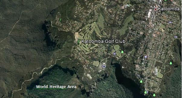 Juxtaposition of the Katoomba Golf Club (light green coloured fairways) replacing virgin habitat across the escarpment; all so that a few retiring Baby Boomer men can selfishly play golf at the expense of Ecology.
[Source: Google Earth, 2013] Juxtaposition of the Katoomba Golf Club (light green coloured fairways) replacing virgin habitat across the escarpment; all so that a few retiring Baby Boomer men can selfishly play golf at the expense of Ecology.
[Source: Google Earth, 2013]
.
During the construction of the additional nine holes [Editor’s Corrigendum: The construction instead related to building 13 townhouses and a resort hotel], the development proposal submitted to the local Blue Mountains Council, specified a new track would be constructed through adjacent bushland to connect two fairways. It was deceptive, because that track became a new wide fairway, complete with soil replacement, landscape contouring, grass seeding and fertilizer.
Repeated instances of sediment run-off from the construction were formally reported to the local Blue Mountains Council by concerned local residents, yet no remediation action was undertaken and no punitive fines were issued.
.
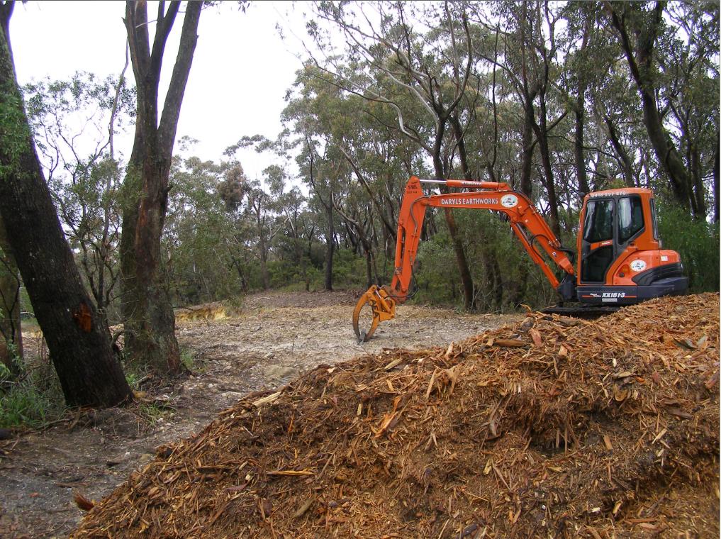 Native bushland along the Blue Mountains escarpment slashed and woodchipped to expand the Katoomba Golf Club out to 18 holes
[Editor’s Corrigendum: The construction instead related to building 13 townhouses and a resort hotel]
[Photo by Editor, 20071110, Photo © under ^Creative Commons] Native bushland along the Blue Mountains escarpment slashed and woodchipped to expand the Katoomba Golf Club out to 18 holes
[Editor’s Corrigendum: The construction instead related to building 13 townhouses and a resort hotel]
[Photo by Editor, 20071110, Photo © under ^Creative Commons]
.
.
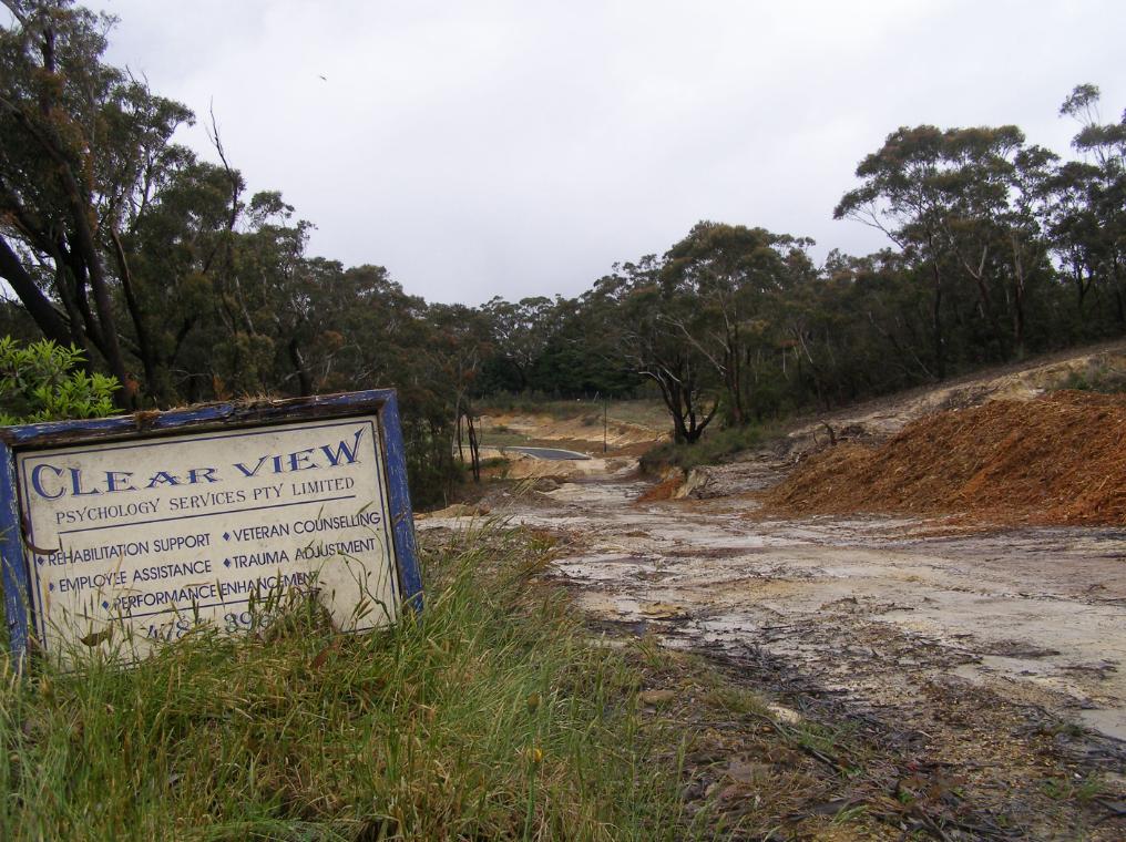 Native bushland bulldozed to make way for golfing townhouses adjacent to the Katoomba Golf Club
Erosion and sediment run-off has been rife for years
[Photo by Editor, 20071110, Photo © under ^Creative Commons]
Native bushland bulldozed to make way for golfing townhouses adjacent to the Katoomba Golf Club
Erosion and sediment run-off has been rife for years
[Photo by Editor, 20071110, Photo © under ^Creative Commons]
.
Golf courses not only necessitate absolute ecological destruction in such places, but the ongoing maintenance of the fairways and greens demands constant fresh water irrigation. Irrigation, as with farming, risks causing saline intrusion into the groundwater.
The keeping of golfing greens green to uphold the lush traditional image, necessitates that golf courses use extensive amounts of chemical fertilizers containing elevated levels of nitrogen (as sulphate of ammonia), potash , sulphur and phosphorus, as well as the application of pesticides and herbicides. All such chemicals are toxic to Australian native vegetation and to aquatic wildlife in the downstream watercourses. Effectively they are environmental pollutants and so next to and upstream of vital World Heritage, use of such chemicals needs to be legally banned.
The local Blue Mountains Council has failed to monitor run-off from the construction activity into the surrounding natural environment. The custodian of the World Heritage Area, National Parks and Wildlife Service, simply isn’t interested.
.
.
 White Elephant golfing townhouses adjacent to the Katoomba Golf Club that have since stood vacant for years
[Photo by Editor, 20071110, Photo © under ^Creative Commons]
.
 << It’s big, blue and beautiful! Blue Mountains National Park is located just 60 kilometres west of Sydney. It is unique in it’s history, its wildlife and world famous scenery…includes the Grose Wilderness, dedicated for its wild unspoilt natural beauty. At Katoomba see the Three Sisters and Katoomba Falls… 300 kilometres of heritage walking tracks and hundreds of lookouts, most within easy reach of a string of train stations. It’s a wilderness made easy to get to! >> << It’s big, blue and beautiful! Blue Mountains National Park is located just 60 kilometres west of Sydney. It is unique in it’s history, its wildlife and world famous scenery…includes the Grose Wilderness, dedicated for its wild unspoilt natural beauty. At Katoomba see the Three Sisters and Katoomba Falls… 300 kilometres of heritage walking tracks and hundreds of lookouts, most within easy reach of a string of train stations. It’s a wilderness made easy to get to! >>
[Source: NSW Government, ^http://www.visitnsw.com/destinations/blue-mountains/katoomba-area/blackheath/attractions/blue-mountains-national-park]
.
[Ed: No mention of golf in the tourism promotion these days]
.
Katoomba Golf Club R.I.P.
.
<<..“the locksmith has been in” and the club is no longer trading.
Unfortunately the club has temporarily closed its doors to the public. They have appointed administrators to handle the business. We are no longer employed. We, the staff thank all of you for your patronage, your friendship, your laughs and your well wishes – it has been a wonderful and memorable time for all of us. A bit of a sad day for us, so thank you. >>
[Source: ‘Katoomba Golf Club shuts its doors’, 20130703, Blue Mountains Gazette, print, p.5, ^http://www.bluemountainsgazette.com.au/story/1614280/katoomba-golf-club-shuts-its-doors/?cs=2062]
.
 Escarpment Karma?
Yet over 50 hectares of vital escarpment habitat has been lost
to a Baby Boomer selfish pastime. Escarpment Karma?
Yet over 50 hectares of vital escarpment habitat has been lost
to a Baby Boomer selfish pastime.
.
Notice of First Meeting of Creditors of Company Under Administration
.
Company: Katoomba Golf Club Ltd
ACN: 000 952 992
Status: Administrators Appointed
Appointed: 01 July 2013
.
Meeting details:
Notice is given that a first meeting of the creditors of the Company, or a first meeting for each of the Companies, (for multiple companies), will be held:
Location: Katoomba Golf Club, Acacia Street, Katoomba New South Wales
Meeting date: 10 July 2013
Meeting time: 12:00PM
.
[Source: ASIC Insolvency Notices].
.
.
‘Fore Sale – Luxury golf communities have hit a rough patch’
[Source: ‘Fore Sale – Luxury golf communities have hit a rough patch’, 20120724, by Nancy Keate, The Wall Street Journal, ^http://online.wsj.com/article/SB10001424052702303703004577474563368632088.html]
.
 Photo Illustration: Jeff Huang
.
<< After years of aggressive golf course expansion, interest in golf declined just as the market for luxury homes plunged. Now, once-pricey real estate is available at below-par prices. Selling a lot for $1.
Debbie Bowers and her husband, tired of life in their cold Ohio town, spent eight years looking for a home near a sunny luxury golf course in a Southern state. Everything they saw was too expensive. Then this past May, they got a call: A lot was available at South Carolina’s Colleton River Plantation, one of the country’s premiere golf communities—for free.
Prices at luxury private golf communities are crashing, done in by rampant overdevelopment, the economic downturn and waning national interest in the sport. Nancy Keates has details on Lunch Break.
The seller was even willing to pay the $15,000 club initiation fee and the first year of $17,000 annual membership dues at Colleton River, which includes three celebrity-designed courses (two by Jack Nicklaus, one by Pete Dye), a Stan Smith-designed tennis center and a new 6,000-square-foot fitness center. Mrs. Bowers, 55, met her husband that day at the site and signed the papers. They’re now building a 3,000-square-foot house that should be finished by November.
The past two decades saw an unprecedented boom in the building of high-end golf courses linked to luxury real-estate communities. Betting that aging Baby Boomers would embrace golf as their pastime of choice, the National Golf Foundation set a goal of building “A Course a Day” beginning in 1988. Real-estate developers teamed up with top-name golf-course architects, building exclusive communities adjacent to courses, and requiring homeowners to pay annual club dues—sometimes even if they didn’t play. Then, in a moment of spectacularly bad timing, both the golf industry and the real-estate market took a nose-dive at once.
Now, private golf communities are dealing with the fallout. Many sellers are dropping their prices radically, in some cases even paying people to take their land. Gated communities that once traded on their exclusivity are aiming to appeal to a wider swath of buyers, building family-friendly “village centers” with ice cream shops, hiking trails and bowling alleys. A few are even “repurposing” by reducing courses to nine holes from 18 and selling off the reclaimed land.
At golf communities near Bluffton, S.C., like Belfair Plantation, Colleton River Plantation and Berkeley Hall, several lots that initially sold for at least $150,000 are now on sale for $1 apiece. Investors who bought but never built on the sites are trying to unburden themselves of the thousands of dollars—typically $12,000 to $17,000—they still have to pay in annual club dues.
At the Mizner Country Club in Delray Beach, Fla., which has an Arnold Palmer golf course, a lakefront home with five bedrooms, a pool and a spa is asking $795,000. It sold for $1.6 million in 2007. A lot in Horseshoe Bay Resort, near Austin, Texas, that sold previously for $300,000, is on sale for $39,000.
In Bend, Ore., interior designer Ronda Fitton and her husband paid $500,000 for a lot at Pronghorn, a gated community with golf courses designed by Tom Fazio and Jack Nicklaus, in 2006. A similar-size lot sold for $10,000 earlier this year. Ms. Fitton is hopeful values will go up but she says the lot is “worth nothing now. It’s a real bummer.” (Lot prices exclude membership fees.) Lots at Rams Hill in Borrego Springs, Calif. are also selling for about $10,000, compared with $100,000 at the peak.
The housing downturn is partly responsible. But the crash in value has been exacerbated by a development binge that resulted in too many courses just as the sport of golf began to fade in popularity.
From 1990 to 2003, some 3,000 new courses were built in the U.S., swelling the total number of courses nationally by 19% and costing about $20 billion, according to the National Golf Foundation.
Many of these new courses were inextricably linked to the luxury-real-estate market. About 40% of the courses built during the 1990s were tied to real-estate communities—a shift from the previous decades, when that number was closer to 18% and the vast majority of golf courses didn’t have people living on them. The golf courses were the lure to get people to buy houses: The bigger the name of the architect who designed them, the greater the prestige and the more expensive the real estate.
Soon after, however, the sport started to lose its allure. The percentage of the overall population in the U.S. that plays golf is down over the past 10 years, from 11.1% in 2000 to 9.2% in 2010, according to the National Golf Foundation.
Last year the number of rounds played in the U.S. dropped to 463 million from 518 million in 2000. The number of golfers fell to 25.7 million in 2011 from 28.8 million in 2000. A net of more than 350 golf courses have been closed since 2005. In 2011, more than 150 courses closed, outpacing the 19 courses that debuted last year.
Compounding the problem: Real-estate developers didn’t think about the viability of the golf courses themselves, says Art West, founder of Golf Course Advisors, a golf-course consulting company. Many of these courses designed by brand-name golf-course architects were championship-level, too difficult for the average player. They took a long time to play and cost millions a year to maintain, pushing up annual dues.
“It was a perfect storm,” says David Hueber, former president and CEO of the National Golf Foundation, who wrote a paper called ” ‘Code Blue’ for U.S. Golf Course Real Estate Development” stemming from research for his Ph.D. in real-estate development at Clemson University.
Across the country, about 2,000 of the 16,000 golf courses are “financially distressed,” according to the National Golf Foundation. Mr. Hueber estimates that 4,000 to 5,000 golf courses will be in financial danger if they don’t change their model.
Membership fees for many clubs have tumbled. The initiation fee at Old Palm Golf Club in Palm Beach Gardens, Fla., which was as high as $250,000 in 2007, is now down to $175,000, while the fee at Tiburon Golf Club in Naples, Fla., is now at $50,000, compared with $145,000 at its peak.
In some parts of the country, the premium that home buyers are willing to pay for a house on a golf course versus a house that isn’t on a course has dropped to about 25%, from 50% in 2007, says Doug Schwartz, who runs the sales, marketing and homebuilding operations for WCI Communities, in Bonita Springs, Fla., which currently owns four golf communities. Lisa Treu, an agent with the Treu Group in Palm Beach County, says homes on golf courses in Southeast Florida could at one time command a 25% premium over non-golf-course homes; that premium has now dropped to about 10%, she says. (Some areas are still strong, like Palm Springs, Calif., where agents say the premiums are as much as 35%).
“There are a lot of people who would like to get out of here because of the economy,” says Don Davis, who with his wife bought a house in South Carolina’s Colleton River for $970,000 in 2001. The couple, who have loved living in the community but want to move back to Atlanta to be closer to their grandchildren, say it doesn’t make financial sense to move without selling their house because they’d still have to pay the community’s annual membership dues of some $17,000. Their house, listed at $775,000, hasn’t had any offers in its six months on the market.
Real-estate agent Dick Datz of Carolina Realty Group says Belfair and Colleton River are offering agents a $5,000 bonus when they sell a $1 lot; otherwise the commission would be pennies. Rob Norton, president of the Colleton River Plantation Board, says houses in the community are selling and there’s lots of new construction. It’s mostly the people who bought the land as an investment who are having a hard time, he says.
Some developers are recasting their golf communities to appeal to a broader swath of home buyers, including more families and young people. One example: Tuscany Reserve, a 450-plus-acre private golf community in Naples, Fla., which had about $200 million invested in its infrastructure, including a golf course designed by Pete Dye and Greg Norman, before it went bankrupt. Florida developer Syd Kitson recently bought the community for $30 million and changed the name to Talis Park, which he thought sounded more youthful. Instead of building a clubhouse as planned, Mr. Kitson, will build a “village center” with a cafe, a spa and walking paths. Homes are now expected to be in the $700,000-to-$2 million range instead of up to $6 million, as originally intended.
“The model of a country club in its current form is gone forever,” says Mr. Kitson.
After seeing sharp decreases in its sale prices, Pronghorn, the gated community in Bend, Ore., opened its gates, launching a 48-suite lodge in 2010 and inviting the public to use one of its two golf courses. The Resort Group, a resort operator based in Honolulu, Hawaii, took over in February and announced it will bring in Auberge Resorts to manage the property, turning it into a five-star resort with a spa, three restaurants, two pools, tennis courts and a kids club.
The Cliffs—a group of eight residential developments spread among 20,000 acres between Greenville, S.C., and Asheville, N.C., with golf courses designed by Jack Nicklaus and Tom Fazio—filed for U.S. Bankruptcy Court protection in February, with estimated liabilities between $100 million and $500 million. A planned golf course for the Cliffs, designed by Tiger Woods, hasn’t been started. According to a 2007 news release, the Cliffs sold 40 lots in the $500,000 price range, and lots at that time couldn’t be purchased below $200,000. Earlier this year a lot sold in one high-end community for less than $10,000, according to real-estate agent Justin Winter.
Owners at the Cliffs, who tried to bail it out earlier by putting up $64 million to keep the club operating, say they are optimistic and are in the midst of a reorganization with Carlile Group, a diversified company based in Marshall, Texas. Carlile is working with two other groups.
Owners say the revamped club will have more options for membership. The initiation fee, which was $150,000, is now $50,000. “We are working diligently to find and deliver the best solution for all members and property owners at the Cliffs,” Steve Carlile of Carlile Group says in a statement.
Golf-course architect Bobby Weed of Bobby Weed Golf Design has been helping residential golf communities over the past few years “repurpose”—by compressing the properties. He is currently working on several proposals to shrink 18-hole courses to nine holes. At the Deltona Club in Deltona, Fla., he helped reduce the amount of land used by the clubhouse and the golf course to create a separate, 17-acre parcel for development.
The steep decline in prices is a boon for potential buyers, of course. “Now I’m getting worried I’m going to miss out if I don’t move quickly,” says Gordon Flach, 44, who has been looking for a golf resort home in Montana, Utah or Oregon for the past three years. Mr. Flach, who is part owner of a resort in the Bahamas, has his eye on a $425,000, 3,800-square-foot four-bedroom house in Pronghorn. A similar house was going for $1.1 million when he first started looking.
Ron Ruff, a 55-year-old semiretired anesthesiologist, got his lot at Pronghorn free about a year ago. The seller also kicked in part of the $115,000 reimbursement of his golf-club membership initiation fee he got back when he “sold” the land. Mr. Ruff says that he felt, despite the dire climate and other people thinking he was crazy, that Pronghorn has a “magical” feel and that the value would be realized again, just as he had seen happen in other areas before. His house is now complete.
John Reed, the original developer of Colleton River Plantation, Belfair Plantation and Berkeley Hall, concedes there are too many golf-course communities. “There’s a train wreck in the industry now,” he says. “We overbuilt and the market stopped.” He had Pete Dye and Tom Fazio design a golf course for his latest development, called Hampton Lakes, but decided to nix it in favor of a 165-acre freshwater fishing and boating lake.
“The best golf course we ever did is 9 feet underwater,” he jokes. >>
.
Tags: baby boomer, Blue Mountains Council, Blue Mountains Escarpment, Blue Mountains World Heritage Area, BMCC, broadscale habitat destruction, chemical fertilizers, Community Land, eco-rapist sport, escarpment slashed, golf, golf course development, golfing townhouses, institutionalised sport, irrigation, Jamison Valley Wilderness, Katoomba Golf Club, run-off, The Escarpments
Posted in Blue Mountains (AU), Threats from Development, Threats from Selling Public Land, Threats from Tourism and Recreation | 8 Comments »
Add this post to Del.icio.us - Digg
Saturday, December 22nd, 2012
 Inky
A pure Fraser Island Dingo Inky
A pure Fraser Island Dingo
persecuted by a colonial-mindset Queensland Government
..left ear ‘tagged’ by rangers and permanently damaged
..since shot by same rangers.
.
Wildlife-based Tourism Exploitation
.
<<Wildlife-based tourism is a major tourism activity and is increasing in popularity. For many international tourists visiting Australia, viewing Australian wildlife forms a major part of their visit (Fredline & Faulkner 2001). For domestic tourists, viewing wildlife and sometimes interacting with it is also an important activity, and it caters for specialists and generalists alike.>>
[Source: ‘Economics, Wildlife Tourism and Conservation: Three Case Studies’, 2004, by Clem Tisdell and Clevo Wilson, CRC for Sustainable Tourism, commissioned by the Australian Government (i.e. taxpayer funded), p.1, ^http://www.crctourism.com.au/WMS/Upload/Resources/bookshop/FactSheets/fact%20sheet.pdf]
.
But it is this ‘Wildlife-based Tourism‘ industry sector where Australian tourism has taken on a dark side. The industry and the revenue and profits it generates are being used by Australian state governments to justify greater destruction of Australia’s fragile ecosystems. This innocuous euphemism is exploited by the Queensland Tourism industry to belie the true destructive ecological impacts of ‘Nature Tourism‘ or ‘Ecotourism‘.
This is like painting a bulldozer green and all subsequent use labelled as ‘eco-bulldozing‘.
 Badge d’Exploitation
.
.At least 50% of a tourism operator’s offerings must have a Nature-based focus
and some vague notion of ‘sustainability’ principles.
Pay our fee…et voilà!’ – eco-certification!
[Read More: EcoTourism Australia (a private company), ^http://www.ecotourism.org.au/] Badge d’Exploitation
.
.At least 50% of a tourism operator’s offerings must have a Nature-based focus
and some vague notion of ‘sustainability’ principles.
Pay our fee…et voilà!’ – eco-certification!
[Read More: EcoTourism Australia (a private company), ^http://www.ecotourism.org.au/]
.
But the most disturbing trend is that even the state government custodians entrusted with ecological protection and conservation, the variously named National Parks and Wildlife Service agencies, have placed the aims of recreation and tourism at a higher management priority than their core function of ecological protection and conservation.
Perhaps this exploitative trend is no more prevalent than across Queensland’s Natural ecology, which is ‘managed’ by the Queensland Government’s Department of National Parks, Recreation and Racing. About Us: <<The department manages national parks and their use and enjoyment by all Queenslanders; encourages active lifestyles by providing recreational and sporting opportunities; and manages the racing industry which directly employs 30,000 Queenslanders.>>
<<Queensland’s parks and forests underpin the State’s thriving nature tourism industry. They attract millions of overseas and Aussie visitors each year and contribute billions of dollars to the Queensland economy. Tourists visiting Queensland’s national parks spend $4.43 billion annually—28% of all total tourist spending in Queensland.>>
[Source: ‘Commercial tourism on parks’, Department of National Parks, Recreation and Racing, Queensland Government, ^http://www.nprsr.qld.gov.au/tourism/]
. Queensland Government’s Coat of Arms Queensland Government’s Coat of Arms
Left: a Red Deer entirely irrelevant to Queenslanders. Right: Queensland’s native Brolga (water bird) symbolising Queensland’s native wildlife population.
The Queensland state motto in Latin, “Audax at Fidelis”, means “Bold but Faithful” – faithful to whom?
Entirely, this emblem is one of the most meaningless and hypocritical of any government.
.
Situated along Queensland’s central coast, World Heritage Fraser Island is a case in point. Here, tourism visitation has become unsustainable to the point of driving the island’s ecological destruction. The Queensland Government’s tourism marketing brands the area the Fraser Coast to take in whale watching in Hervey Bay, Reef diving and Fraser Island. The exploitation of Wildlife-based Tourism is focused on maximising visitation numbers, as if bureaucratic commissions are earned according to visitation numbers.
 Commercial tourism unethically/illegally too close to a Humpback Whale
Yet this image appears on the official Queensland Government tourism website (20121222)
[Source: ^http://www.queenslandholidays.com.au/destinations/fraser-coast/fraser-coast_home.cfm] Commercial tourism unethically/illegally too close to a Humpback Whale
Yet this image appears on the official Queensland Government tourism website (20121222)
[Source: ^http://www.queenslandholidays.com.au/destinations/fraser-coast/fraser-coast_home.cfm]
.
") The Australian National Guidelines for Whale and Dolphin Watching 2005
[Source: Australian Government,
^http://www.environment.gov.au/coasts/species/cetaceans/whale-watching/] The Australian National Guidelines for Whale and Dolphin Watching 2005
[Source: Australian Government,
^http://www.environment.gov.au/coasts/species/cetaceans/whale-watching/]
.
Fraser Island’s native top order predator, the Dingo, has been on Fraser Island for at least 1000 years. But the Dingo and its fragile ecology are being persecuted and destroyed by the Queensland Government because the prevailing 20th Century exploitative attitude is that Bevan Tourism generates income; Dingoes don’t. The wildlife tourism promotion of Fraser Island by the Queensland Government has exploited ‘the thrill of seeing a dingo ‘in the wild’ and used the Dingo as a major tourism drawcard.
 Dingo Tourism on Fraser Island is actively encouraged by the Queensland Government
Fraser Island Discovery, with its dingo logo shown above, won a recent Queensland Government Tourism Award Dingo Tourism on Fraser Island is actively encouraged by the Queensland Government
Fraser Island Discovery, with its dingo logo shown above, won a recent Queensland Government Tourism Award
.
Bevan Tourism
.
Bevan Tourism is the exploitative, destructive and disrespectful tourism that appeals to the uncouth, loud mouthed, red neck, yobbo, hoon element of Queensland society.
Particular to parochial Queensland, the ‘Bevan‘ is characteristically a young poorly educated Caucasian male usually very thin, or sometimes quite fat with the onset of manboobs, and displaying the clichéd antisocial behaviours such as hooliganism, swearing, reckless driving, alcoholism, Winnie blue smoking (with spare fag ducked behind ear), XXXX/Bundy Rum drinking, and habitually louting around in front of sheilas.
 Bevans at Play Bevans at Play
.
Bevans are best avoided, especially at social gatherings, sports events, beaches and at campsites. (See also: ‘Bogan’ (Melbourne), ‘Westie’ (Sydney), ‘Ned’ (Glasgow), ‘Yob’, ‘Bozo’, ‘Low-Life’).
 A Queenslander Bevan, royally succumbed to recreational stupor A Queenslander Bevan, royally succumbed to recreational stupor
.
Bevan Tourism has taken cultural hold over a few popular holiday destinations along the Queensland coast. Over the past few generations, Bevans mainly from metropolitan Brisbane have particularly targeted the Gold Coast, Maryborough and Fraser Island.
 Queensland’s Bevan Tourism most exquisitely expressed here by Fraser Explorer Tours Queensland’s Bevan Tourism most exquisitely expressed here by Fraser Explorer Tours
– on Fraser Island
.
Fraser Island, despite being recognised and listed as a Natural World heritage site since 1992, each holiday season is invaded by Bevan Tourism, targeted especially over Easter. In part this is because, Queensland Government’s own state tourism department, in cahoots with its national park agency, has marketed Fraser Island for ‘adventure’, ‘parties’, and ‘families’. Fraser Island’s international listing has been exploited as a tourism drawcard, more so than properly conserved for its internationally important remnant ecosystems, wildlife and flora.
The disturbing trend is that the in mindset of parochial Queensland Tourism, Bevan Tourism is marketed as an equitable right for all people, and that Nature exists in an anthropocentric sense simply to serve that right. This attitude to ecology is retrograde and straight out of the ancient Old Testament:
.
<<And God said, Let us make man in our image, after our likeness: and let them have dominion over the fish of the sea, and over the fowl of the air, and over the cattle, and over all the earth, and over every creeping thing that creepeth upon the earth.>>
[Source: Book of Genesis, 1:26, Christian Bible, Old Testament]
.
 The ‘Dominion Theology’ worldview of Nature
It’s there to be used, feared, exploited, persecuted, poached, butchered, eaten, enslaved, raped, shot, hacked, played with as sport, made extinct. The ‘Dominion Theology’ worldview of Nature
It’s there to be used, feared, exploited, persecuted, poached, butchered, eaten, enslaved, raped, shot, hacked, played with as sport, made extinct.
.
Fraser Island heritage avoids Conservation
.
") Pure Fraser Island
[Source: Australian Geographic,
^http://www.australiangeographic.com.au/journal/view-image.htm?index=8&gid=9642] Pure Fraser Island
[Source: Australian Geographic,
^http://www.australiangeographic.com.au/journal/view-image.htm?index=8&gid=9642]
.
Fraser Island, the world’s largest sand island, was afforded UNESCO World Heritage status because it satisfied the following three selection criteria:
- Superlative natural phenomena or areas of exceptional natural beauty and aesthetic importance (Natural Criterion 7)
- Outstanding examples which represent major stages of earth’s history, including the record of life, significant ongoing geological processes in the development of landforms, or significant geomorphic or physiographic features (Natural Criterion 8 )
- Outstanding examples representing significant ongoing ecological and biological processes in the evolution and development of terrestrial, fresh water, coastal and marine ecosystems and communities of plants and animals (Natural Criterion 9)
[Source: ‘Fraser Island World Heritage Area’, Department of National Parks, Recreation, Sport and Racing, Queensland Government, ^http://www.nprsr.qld.gov.au/world-heritage-areas/fraser_island.html]
.
Despite these recognise over-arching natural values, tourism and its negative impacts have been allowed to snowball in visitation volume since heritage listing in 1992, while custodial management has allowed the same values to deteriorate.
What has been conspicuously overlooked is proper recognition of Fraser Island’s status under UNESCO Natural Criterion 10, for surely Fraser Island ‘contains the most important and significant natural habitats for in-situ conservation of biological diversity, including those containing threatened species of outstanding universal value from the point of view of science or conservation.’
The custodianship of such valuable World Heritage properties across Australia is the ultimate responsibility of the Australian Government.
While Australia’s World Heritage properties are legally protected under the Environment Protection and Biodiversity Conservation Act 1999 (EPBC Act), conveniently responsibility for that protection is rather half-hearted since the Australian Government delegates management of all of them to the lesser state governments, which have considerably less resources and demonstrably less interest in delivering UNESCO-standard ecological conservation management.
 ^United Nations Educational, Scientific and Cultural Organization ^United Nations Educational, Scientific and Cultural Organization
.
The Queensland Government for instance, currently lumps Fraser Island management under its Department of National Parks, Recreation, Sport and Racing. Clearly, the attitude of the Queensland Government to World Heritage and National Parks under its custodial responsibility exists for human recreational benefit and enjoyment – along with sport and racing.
.
Fraser Island’s Record of Exploitation
.
Prior to 1992, Fraser Island was industrially abused; mined for minerals and sand (1966-1989) and logged for old growth Turpentine timber (Syncarpia glomulifera) for over 130 years.
[Read: > ‘Impacts of Logging on Fraser Island’]
Fraser Island’s ecosystems (its rainforests, Wallum woodlands, freshwater dune lakes and coastal dunes) came close to irreversible annihilation by over-exploitation by these two industries and condoned for such by successive Queensland governments.
Since logging and mining were stopped (only from international embarrassment), Queensland’s Tourism Industry has been supplanted as Fraser Island’s main threat, yet consistently encouraged and funded doggedly by a 20th Century mindset Queensland Government.
Wild Dingo
Australia’s native top order predator
promoted by the Queensland Government as a tourism drawcard to Fraser Island
culled by the Queensland Government from 300 down to just 100 individuals
shot by the Queensland Government if ‘aggressive’ (wild)
.
<<Fraser Island tourism has been burgeoning for decades. In 1971 the number of visitors to Fraser Island doubled from 5,000 in the previous year to 10,000 as a result of the publicity surrounding the sandmining controversy. It has steadily increased ever since. By 1999 it had reached over 300,000 visitors.>>
Current statistics for Fraser Island visitation are not readily published by the Queensland Government, but it is estimated that around 500,000 visitors, many from overseas, visit Fraser Island each year. [Source: ‘Concerns heightening for Fraser Island’s dingoes’, 2009, by Nick Alexander, in Ecos Magazine, ^http://www.ecosmagazine.com/view/journals/ECOS_Print_Fulltext.cfm?f=EC151p18]
 Hummers catering for Bevan Tourism
– on Fraser Island Hummers catering for Bevan Tourism
– on Fraser Island
.
<<For Lake McKenzie (Fraser Island) in particular, extremely high visitation levels over the course of summer are ultimately likely to influence the ecology of the system, particularly if a considerable proportion of visitors add nutrients to the lake, either through urination, washing or bathing activities (Strasinger 1994, Butler et al. 1996).>>
.
[Source: ‘Effects of Tourism on Fraser Island Dune Lakes‘, 2004, by Wade Hadwen et al.
Read the complete paper below under the heading ‘Read more about Tourism Impacts on Fraser Island‘]
.
The Four Main Adverse Impacts of Tourism on Fraser Island
.
1. Target Destinations (high concentration visitation)
.
Certain Fraser Island areas are identified and marketed by tourist interests with the result that they draw tourists to them like bees to a honey pot even to the extent that they become needlessly degraded and overused. Eli Creek, Lake McKenzie and Central Station are such sites.
Daily hundreds of tourists from the Noosa area spend needless hours to drive past equally outstanding natural features in the Cooloola National Park so that commercial tour operators can capitalize on the “marketing of these well-known products”. This focus is unsustainable.
Such sites are being overused and yet tourists are reluctant to be redirected to other alternative areas which could sustain some increase in visitation.
 Tourist saturation of Eli Creek, Fraser Island
(Dingo habitat designated off-limits to Dingoes) Tourist saturation of Eli Creek, Fraser Island
(Dingo habitat designated off-limits to Dingoes)
.
2. Means of Access
.
Once tourism becomes established, it is difficult to change.
Tourist guide books tend to be based upon past experience. Recommendations to intending visitors are largely based on such past practice. Thus although there are better ways to see Fraser Island than in largely lumbering four wheel drive buses or self of four wheel drive vehicles, this method of visitation has become so entrenched that it is difficult to change.
The most serious adverse environmental impacts now being experienced on Fraser Island are result of this form of transportation.
 Ban 4WDs from Fraser Island
Change the 20th Century culture! Ban 4WDs from Fraser Island
Change the 20th Century culture!
.
3. “Traditional” Visitation Practices
.
It takes very little time for modern society to claim that certain practices are so “traditional” that practitioners claim they can’t be changed.
This has been used by commercial fishers to demand to camp in the same site contrary to the Recreation Areas Management Act and to have vehicular access to beaches closed to other vehicular traffic.
Likewise the “tradition” of free range camping has become so entrenched that although this practice has been shown to be unsustainable there is a reluctance to phase it out despite compelling evidence that this form of tourism should be ended. Similar conservatism allows Fraser Island tourists to continue to squander resources and degrade the environment through open camp-fires.
.
4. Surface Disturbance
.
On Fraser Island, the impact of surface disturbance of any sort is more critical than most other natural areas which have a much more robust substrate (ground surface).
The susceptibility of the substrate to any disturbance magnifies the impacts of tourism on Fraser Island more than most other natural areas. (Coral reefs and semi-arid areas with cryptobionic crusts may be as susceptible to disturbance). The reason for this fragility is due to the fact that exposed sand surfaces in vegetated areas of Fraser Island have a very high degree of water repellence which makes them very susceptible to water erosion. Vegetated sand surfaces are much less susceptible.
If the visitors can be carried in such a way that they do not disturb the substrate surface by such means as board walks or by light rail, then the surface disturbance and thus the environmental impact of visitation is contained and reduced.>>
 . .
Further Tourism Impacts
.
5. Erosion of Wilderness Values
.
Tourism erodes wilderness values through its infrastructure — motor vehicles, roads, modern buildings and the sounds of modern engines. The increasing penetration of more people into parts of the island previously exempt from intense visitation erodes wilderness. Aircraft overflying remoter parts of Fraser Island and other intrusive modern noise also erodes wilderness values.
.
6. Spread of Injurious Agents
.
Injurious agencies which impact on other values of Fraser Island include the spread of weeds, feral animals and pests, new pathogens, wild fires and litter. Tourism has the potential to facilitate the introduction and spread of these injurious agencies. In the end the impact of injurious agencies resulting from tourism have a greater potential to degrade Fraser Island than some other industries.
.
7. Diversion of Management Resources
.
Managing tourism is responsible for diverting much of Fraser Island’s very limited resources from natural resource management (control of fires, weeds, feral animals etc. and resource monitoring) to recreation management (including access, waste management, behaviour control, provision of infrastructure, maintenance for roads, etc.). Tourism produces a great deal of waste and human waste and this is resulting in some water pollution particularly as a result of inadequate treatment of sewage.
Increasing numbers of tourists also impede natural resource management strategies such as fire and dingo management because of the high priority given to public safety and property protection over resource management and protection.
.
8. Perversion of political priorities
.
Pandering to perceived tourist demands has resulted in political decisions which have over-ridden the Management Plan for Fraser Island such as relocating the Toyota Fishing Expo and reopening the dangerous Orchid Beach airstrip. Many politicians are motivated more by pursuing popularity than with implementing a Management Plan which some vocal dissidents with vested interests disagree with.
 A Queensland Tourism ideal image for Fraser Island
Maximising 4WD tourist numbers! A Queensland Tourism ideal image for Fraser Island
Maximising 4WD tourist numbers!
.
Motor Vehicle Impacts
 4WD road widening of Fraser Island 4WD road widening of Fraser Island
.
The impact of four wheel drives on Fraser Island is extremely significant; affecting roads, wildlife, habitat and recreation amenity.
.
9. Roads
.
The largest impact is on the roads. Road traffic accelerates erosion. During every heavy downpour of rain thousands of tonnes of sand wash off the roads to fill lake basins and streams with sediment and smother many natural habitats. In February 1999, over two metres of sand was deposited at the intersection of the Pile Valley and Wanggoolba Creek Road burying a large stump. Sand from adjacent roads is being sluiced into Lake McKenzie, Lake Allom, Lake Boomanjin, Lake Birrabeen and more.
Opening of the canopy over the roads results in desiccation resulting in considerable changes to the micro-flora and a reduction of ^epiphyte numbers.
.
10. Impacts on Wildlife
.
Back in 1991, when Fraser Island was listed for its natural world heritage values, its Dingo population was about 300 individuals and believed to be ‘the largest genetically
unhybridised population on the east coast of Australia.
But Bevan Tourism saw increasing numbers of young families recklessly venturing into the wild Dingo’s habitat and feeding grounds. During one of the busy tourist holiday times, Christmas summer holidays, a young child was mauled by a dingo, and an ignorant vengeful media campaigned to demonise the Dingo. The media venom fabricated the term ‘Dingo Superpack‘.
During the following six years, the Queensland Government ordered the killing of over a hundred Dingoes on Fraser Island. In 2001, a nine-year-old schoolboy, Clinton Gage, was fatally mauled by a Dingo, which sparked another media Dingo witch-hunt, and a further 32 Dingoes were killed within a matter of a few weeks by the Queensland Government.
An infant (4 years old) was badly bitten by a Dingo on Fraser Island in April 2007 and another 3 year in April 2011. Both incidents occurred during the popular Bevan Tourism Easter holidays. Both involved irresponsible parents. In July 2012, a drunken German tourist, sleeping it off alone on an isolated bush track at night, was attacked by a Dingo. He was part of Bevan Tourist group organised by the Rainbow Beach Adventure Company.
Despite the protection status of the Dingo in its native habitat in a listed World Heritage Area, the Queensland Government has ignored the wildlife values and rights in favour of perpetuating Bevan Tourism rights. It has become standard management practice for the Queensland Government’s Parks and Wildlife Service to shoot kill any ‘aggressive’ animal or animal that ‘shows no fear of humans’ – that is, Dingoes.
 Dingo pup tagged by rangers on Fraser Island, November 2012
Another ear permanently damaged Dingo pup tagged by rangers on Fraser Island, November 2012
Another ear permanently damaged
.
Since 2009, researcher Dr Luke Leung from Queensland University, has feared the population has been reduced to around 100 animals and their genetic viability over the long term is being compromised.
In addition, shore bird numbers have been decimated by the unchecked growth of four wheel drive beach traffic. Oyster catchers, Red-capped dotterels and Beach thick-knees have been most affected.
.
11. Eroding Habitat
.
Roads occupy space, a space which takes a long time to revegetate after the roads cease to be used. Roads also act as barriers to the movement of wildlife. Distribution of many ant species and frogs is affected by roads. Some won’t cross roads to identical habitat on the other side.
As a consequence of habitat destruction, the availability of natural prey of the Dingo, such as bandicoots, rats, echidnas, fish, turtles and skinks, has declined. Dingoes have been forced to scavenge around tourist campsites for human food and garbage. Tourists ignorantly feeding Dingoes has encouraged Dingoes to become less independent upon reduced natural prey and more dependent on tourists, which has adversely altered the natural food chain only the island.
.
12. Pollution
.
Now there evidence is starting to appear that vegetation adjacent to “black holes” in the roads is suffering.
.
13. Noise
.
The aesthetic impact of noise is well known and understood yet it is largely ignored. The impact of the noise from traffic on the road above Wanggoolba Creek on the walking track beside this icon of Fraser Island significantly degrades this experience.
.
14. Distortion of Priorities
 Populist politicians condone novel commerce ahead of novel solutions Populist politicians condone novel commerce ahead of novel solutions
.
Because so much of Fraser Island tourism is vehicle based, roads have been cannibalistic, consuming a disproportionate share all the financial and staff resources.
This stopped any progress towards a walking track management plan for the island for more than six years. Vehicle based tourism has also been responsible for preventing closing tracks due to be closed under the Management Plan for more than 6 years. Preoccupation with roads has stalled progress towards the establishment of a more ecologically sustainable light rail proposal.>>
.
[Sources: ‘Values of Fraser Island Tourism’, Fraser Island Defenders Organisation (FIDO), ^http://www.fido.org.au/values-of-fraser-tourism.html; ‘Concerns heightening for Fraser Island’s dingoes’, 2009, by Nick Alexander, in Ecos Magazine, CSIRO Publishing, Australia. ^http://www.ecosmagazine.com/view/journals/ECOS_Print_Fulltext.cfm?f=EC151p18]
.
Read more about Tourism Impacts on Fraser Island
.
[a] ‘Fraser Island Discussion Paper and Recommendations‘, Aug 2010, Queensland Liberal National Party (LNP) while in opposition (in government since March 2012), ^http://savefraserislanddingoes.com/pdf/Fraser%20Island%20Discussion%20paper%20and%20recommendations%2023.8.10.pdf, [>Read Report 570kb, PDF]
.
[b] ‘Effects of Tourism on Fraser Island Dune Lakes‘, 2004, by Wade Hadwen, Angela Arthington, Stuart Bunn and Thorsten Mosisch, Sustainable Tourism Cooperative Research Centre, research project funded by the Australian Government (i.e Australian taxpayers), ^http://www.crctourism.com.au/wms/upload/images/disc%20of%20images%20and%20pdfs/for%20bookshop/documents/hadwen21001_fraserisdlakes.pdf
Brief Abstract:
<<In light of the rapidly growing tourism industry in the region, excessive tourist use of the dune lakes on Fraser Island could deleteriously affect their ecology and in turn, their aesthetic appeal to tourists. The findings from this research study suggest that the current level of tourist pressure on the perched dune lakes on Fraser Island is likely to have a significant long-term impact on the ecological health of these systems.>> [>Read Report 830kb, PDF]
.
[c] Read related articles on this website by The Habitat Advocate: >Fraser Island Hoon Tourism out of control
.
 Tourist Dingo Branding of Fraser Island Tourist Dingo Branding of Fraser Island
.
National Parks ‘Tourism Playground’ imperative
.
 This ‘Godzilla’ bus especially caters for Bevans to Fraser Island This ‘Godzilla’ bus especially caters for Bevans to Fraser Island
.
Day-to-day management and protection of the World Heritage property is carried out by the Queensland Government’s Department of National Parks, Recreation, Sport and Racing’s – Queensland Parks and Wildlife Service (QPWS). Much of their focus and activities is with accommodating the interests of tourists, not with respecting the viability, health of the Island’s important ecosystems, fauna and flora.
The Queensland Government has a revolving record of failed conservation management plans and strategies, reviewed and replaced since the Fraser Island Management Plan of 1975. This includes revisions in 1978, 1986, 1991, 2001, and 2006. The current strategy dated 2001 is termed the Fraser Island Dingo Management Strategy (FIDMS).
Read: >Fraser Island Dingo Management Strategy (2001) (PDF, 270kb)
The overall objectives of the Dingo Management Strategy are to:
- Ensure the conservation of a sustainable wild dingo population on Fraser Island (Ed: numbers not specified, Dingo recovery programme non-existent)
- Reduce the risk to humans (Ed: kill native Dingoes if deemed ‘aggressive’ or ‘showing no fear of humans’)
- Provide visitors with safe opportunities to view dingoes in environment in near as possible to their natural state (Ed: exploit native Dingoes and their habitat for the benefit of wildlife-based tourism revenue)
.
The current Dingo Management Strategy includes a deliberate Dingo persecution set of directives:
Strategy 4: Programs will be implemented to modify dingo behaviour and habits which threaten human safety and wellbeing.
Strategy 5: Any dingo identified as dangerous will be destroyed humanely using accepted methods after receiving appropriate approvals.
Strategy 6: A cull to a sustainable level may be undertaken if research can show the population is not in balance.
 A pure Dingo’s cruel fate A pure Dingo’s cruel fate
.
.
“What is life? It is the flash of a firefly in the night. It is the breath of a buffalo in the winter time. It is the little shadow which runs across the grass and loses itself in the Sunset.”
~ Chief Crowfoot (c.1821-1890) of the SikSika Nation of southern Alberta, Canada.
.
Implementation of the current Dingo Management Strategy prescribes “direct management of dingoes (destruction of individuals or prescribed culling)…implemented if supported
by the results of research and/or in situations where risks to human life or safety are unacceptably high and cannot be diminished through alternative measures.
Responsibilities of the dingo management Rangers include:
- Public contact to inform Island visitors of appropriate behaviour concerning dingoes
- Enforcement of dingo-related regulations
- Monitoring and recording the status of dingo packs in their management unit (photographic records)
- Marking and tagging pups and problem animals
- Involvement in aversive conditioning projects
- Maintaining dingo-related equipment (traps, fences, dingo incident sheets)
- When authorised, the trapping and destruction of problem dingoes
.
 Andrew Powell MP, purely for the Media Andrew Powell MP, purely for the Media
Queensland Government’s current Minister for Environment and Heritage Protection
.
“People…especially people in positions of power…have invested a tremendous amount of effort and time to get to where they are. They really don’t want to hear that we’re on the wrong path, that we’ve got to shift gears and start thinking differently.”
~ David Suzuki
.
‘Island Playground’ dictates Dingo Culling
.
2009: ‘Residents protest Fraser Island dingo cull’
.
<<Hervey Bay residents met last night and called for an end to the hazing and culling of dingos on Fraser Island. Submissions to the review of the State Government’s dingo management strategy closes next week. Seven dingos have been killed this year compared to three last year. The Opposition’s climate change and sustainability spokesman Glen Elmes says the Government needs to listen to the community.
“We have a situation where the current system and the planning that’s put place to deal with dingos on Fraser Island is all wrong – that’s not me swanning in for half an hour and making that statement. We had a meeting in Hervey Bay last night and we listened to about 30 locals, who represented not only the indigenous community but concerned locals from both the mainland and the island.”>>
[Source: ‘Residents protest Fraser Island dingo cull’, 20090528, by Katherine Spackman, ABC, ^http://www.abc.net.au/news/2009-05-28/residents-protest-fraser-island-dingo-cull/1697234]
.
2012: ‘Dingo eludes Fraser Island rangers’
.
<<Rangers on Fraser Island have destroyed another dingo at Cathedral Beach, but the K’Gari camp dog ‘Inky‘ still eludes them.
QPWS has decided to bring in a hired gun, a trapper, to destroy this animal. Is this the future of Fraser Island? Residents and visitors are encouraged to throw sticks, shout and kick sand at the animals and to ‘dob in a dingo‘. Some residents have even been advised to shoot them with a slingshot. There is no responsibility placed upon parents who leave children unsupervised or visitors who harass the animals, no fines or penalties, but the dingo pays the ultimate penalty and is destroyed.
The Regional Manager, Ross Belcher, admits the camp dog did not bite anyone, nor did the animal that was recently destroyed, but it has a destruction order because of a complaint by tourists who are considered unreliable and have no understanding of dingo behaviour.
This dingo has been wounded, has a mangled ear due to an infected ear tag and as a result is very wary. Therefore it would seem QPWS has achieved its aim of making the animal fearful of people, why then do they continue their campaign of search and destroy?
Locals lament a time when the dingoes could roam free and occasionally steal a fish or grab a towel from an unsuspecting tourist, it was all part of the Fraser Island experience, but now that animal would be considered dangerous and destroyed.
Unless the Management Strategy review finds in favour of the dingo and not the tourist dollar, the persecution and harassment will continue until there are no longer any animals remaining, this is the legacy of Fraser Island.>>
[Source: ‘Dingo eludes Fraser Island rangers..’, October 2012, by Cheryl Bryant, Save Fraser Island Dingoes Inc., ]
.
 Queensland Government Rangers ‘hazing‘ a Dingo pup in its native Fraser Island habitat Queensland Government Rangers ‘hazing‘ a Dingo pup in its native Fraser Island habitat
.
‘Hazing’?
.
<<Hazing is harassment, where you disturb the animal’s sense of security to such an extent that it decides to move on.
To be effective, harassment must be continuous, concentrated, and caustic, just like torture.
Always remember that you are trying to convince an animal to leave its home or food source. In short, you must become the animal’s worst neighbor. You must convince the animal that you are more bothersome than the possibility of starvation or homelessness.
.
I. Continuous Harassment
You must harass the animal on a daily basis for as long as necessary. Don’t be surprised if this activity goes on for weeks.
.
II. Concentrated Harassment
Your efforts must focus on the animal causing the problem. For example if you are using noise it must be centered at where the animal is living. Failure to concentrate the harassment technique simply makes the animal get used to the problem because the problem will be everywhere. It’s like living in N.Y. City. You get used to the traffic noise.
.
III. Caustic Harassment
The harassment technique must be bothersome to the animal. The greater the discomfort to the animal the faster the technique will develop results. Warning: when you harass an animal there are no guarantees where it will decide to take up residence next. It is not out of the question that a raccoon, upon leaving your chimney will decide to enter your attic.>>
.
[Source: Internet Centre for Wildlife Damage Management, America, ^http://icwdm.org/ControlMethods/Hazing.aspx]
.
 Bevans in typical distress on Fraser Island Bevans in typical distress on Fraser Island
.
.
Related Articles (this website)
.
[1] >Dingo Ecology deserves respect on Fraser Is
.
[2] >Remove all ferals from Fraser Island
.
[3] >Dingo: Australia’s ancient apex predator at risk
.
[4] >Fraser Island Hoon Tourism out of control
.
 Queensland Tourism Legacy Queensland Tourism Legacy
.
.
Further Reading
.
[1] Save Fraser Island Dingoes Inc., President: Malcom Kilpatrick. President, Website: ^http://savefraserislanddingoes.com/
.
[2] Australian Wildlife Protection Council, President: Maryland Wilson, ^http://www.awpc.org.au
.
[3] ‘Fraser Island Dingo Management Strategy‘, November 2001, Environmental Protection Agency – Queensland Parks and Wildlife Service (QPWS), Queensland Government, ^http://www.nprsr.qld.gov.au/register/p00500aa.pdf [>Read Strategy]
.
[4] ‘Review of The Fraser Island Dingo Management Strategy – Terms of Reference‘, Department of Environment and Heritage Protection,
^http://www.ehp.qld.gov.au/wildlife/livingwith/dingoes/pdf/fidms-review-tof.pdf [>Read Strategy]
.
[5] ‘Fraser Island Dingo Management Strategy – Review‘, December 2006, ^http://www.nprsr.qld.gov.au/register/p02215aa.pdf [>Read Report]
.
[6] ‘Stakeholder Workshop‘ . A vague title, but yet another…Fraser Island Dingo Management Strategy Review, this time by Ecosure (consultancy outsourced by Queensland Government), 20121005, ^http://www.ecosure.com.au/business-units/wildlife-management/alias/fidms/, http://www.ecosure.com.au/uploads/documents/ibis/Stakeholder%20workshop%20-%20summary.pdf [>Read Summary]
.
[7] ‘A History of Fraser Island‘, 2011, by Pat O’Brien, President, Wildlife Protection Association of Australia Inc., ^http://www.awpc.org.au/img/A_History_of_Fraser_Island_2011_by_Pat_O__Brien..pdf [>Read Paper]
.
[8] Wildlife Protection Association of Australia Inc. (WPAA), PO Box 309, Beerwah, Queensland Australia, 4519, President: Pat O’Brien, ^http://www.wildlifeprotectaust.org.au/
.
[9] Coalition for Wildlife Corridors, Kindness House, 2nd Floor, 288 Brunswick St, Fitzroy 3065, Victoria, Australia, (no website found)
.
[10] ‘ If they could talk to the animals…‘, book by Jonathan Knight, in Nature, Vol.414, pp.246-247, (no website found)
.
[11] ‘Vanishing Icon, the Fraser Island Dingo‘, by Jennifer Parkhurst, 2010, Grey Thrush Publishing, ^http://www.fraserislandfootprints.com/?page_id=694,
Main Website: ^http://www.fraserislandfootprints.com/
") . .
[12] ‘Dingo‘, by Brad Purcell, 2010, CSIRO Publishing, ^http://www.publish.csiro.au/pid/6430.htm
Abstract:
<<Many present-day Australians see the dingo as a threat and a pest to human production systems. An alternative viewpoint, which is more in tune with Indigenous culture, allows others to see the dingo as a means to improve human civilisation. The dingo has thus become trapped between the status of pest animal and totemic creature. This book helps readers to recognise this dichotomy, as a deeper understanding of dingo behaviour is now possible through new technologies which have made it easier to monitor their daily lives.
Recent research on genetic structure has indicated that dingo ‘purity’ may be a human construct and the genetic relatedness of wild dingo packs has been analysed for the first time. GPS telemetry and passive camera traps are new technologies that provide unique ways to monitor movements of dingoes, and analyses of their diet indicate that dietary shifts occur during the different biological seasons of dingoes, showing that they have a functional role in Australian landscapes.
Dingo brings together more than 50 years of observations to provide a comprehensive portrayal of the life of a dingo. Throughout this book dingoes are compared with other hypercarnivores, such as wolves and African wild dogs, highlighting the similarities between dingoes and other large canid species around the world.>>
") . .
[13] ‘Butchulla people – Traditional Owners of K’gari (Fraser Island)‘, by Dale Lorna Jacobsen, ^ http://dalelornajacobsen.com/5_butchulla_website; Also: ^http://dalelornajacobsen.com/yahoo_site_admin/assets/docs/Butchulla_pathways.24174426.pdf, [>Read Brochure, PDF, 2.8MB (large file, so may take a while to download)]
.
[14] ‘Finding Fraser Island‘ by Ken Eastwood, in Australian Geographic, Vol.107, March – April 2012, pp. 67-79.
.
[15] ‘Fraser Island World Heritage Area‘, Department of National Parks, Recreation, Sport and Racing, Queensland Government, ^http://www.nprsr.qld.gov.au/world-heritage-areas/fraser_island.html
.
[16] ‘When Wildlife Tourism Goes Wrong: A Case Study of Stakeholder Management Issues Regarding Dingoes on Fraser Island, Australia‘, May 2006, by Georgette Leah Burns and Peter Howard, Faculty of Environmental Sciences, Griffith University, Queensland, Australia, ^http://www98.griffith.edu.au/dspace/bitstream/handle/10072/6029/When_wildlife…?sequence=1, [>Read Paper, PDF, 175kb]
.
[17] A Draft Dingo Management Strategy for Fraser Island, by the Fraser Island Defenders Organisation (FIDO), ^http://www.fido.org.au/DingoManagement.html
See reproduced as follows..
.
An Ecologically Respectful Custodial Strategy for Fraser Island (by FIDO).
.
<<For more than 28 years, the Fraser Island Defenders Organization has been researching the management of Fraser Island to be in the best position to advocate the wisest use of its natural resources. The organization has a longer history associated with the management than any other organization, including the Queensland Parks and Wildlife Service and its predecessors.
The Fraser Island Defenders Organization has studied and considered the Draft Fraser Island dingo management strategy prepared by the Queensland Parks and Wildlife Service and this submission is a response to that document released in April, 1999.
This organization has examined Draft Dingo Management Strategy and recommends some very important issues which need to be recognized and also some significant changes which need to be made to the actions.
.
1. FIDO wants the genetic status of Fraser Island dingoes recognized and protected.
2. Dingoes should be allowed to remain free to roam in the wild on Fraser Island.
3. The strategy should address all of the issues relating to the dingo population, including the characteristics, and the changes during the past century.
4. There is a need to review the population dynamics of Fraser Island dingoes to ensure that the island environment is managed to achieve an optimum dingo population. This needs to recognize that historically there was a much higher population on Fraser Island.
5. Dingoes should not suffer because of the intervention of humans which have induced changed behaviour.
6. A humane system of tagging should be established and all Fraser Island dingoes should be individually identified to provide more precise data on the actual population numbers and to assist in further research on animal behaviour.
7. The strategy should recognize how environmental changes during the last century on Fraser Island have impacted on dingoes and move to minimize these impacts.
8. The QPWS should develop a code of conduct which not only outlaws feeding of dingoes but also one which stops people encouraging dingoes to approach closer than 10 metres to be photographed thus encouraging them to loose their wariness of humans.
9. FIDO generally supports the first four recommendations of the Draft Dingo Management Strategy but is opposed to the recommendations for relocation, destruction, and culling.
.
1. Significant Omissions
There are a number of significant omission in the Draft Fraser Island dingo management strategy. The most important omission seems to be a clear objective for the strategy. Other omissions relate to the history of the dingo on Fraser Island, the significance and genetic purity of the dingoes on Fraser Island, the status of dingoes and the impact of environmental changes during the last 100 years.
1.1 The need for a clear objective: The Strategy should clearly state its objective. Without such an objective being clearly and publicly stated implementations of the final three recommendations could result in the extermination of the dingoes on Fraser Island. Is it to protect people from harassment by dingoes or is it to protect the animals? Is it to be an outcome that the genetic strain of Fraser Island dingo is only to be preserved in a zoo or behind barriers or is it to ensure that dingoes are to be allowed to roam wild on Fraser Island?
At present the objective could be construed only as stopping dingoes attacking humans.
The Fraser Island Defenders Organization believes the Final Management Strategy should carry wording such as:
“The biologically importance of the Fraser Island dingo strain is a value which must be preserved in as pure a form as possible. The fact that dingoes have lived on Fraser Island in the wild for thousands of years makes it important that the dingoes are allowed to roam as wild and unconfined animals on Fraser Island.
“The object of this strategy is predicated by the need to ensure that a viable wild population of dingos is maintained on Fraser Island.”
1.2.1 History: The bibliography of the Draft Fraser Island Dingo Management Strategy fails to include any reference to any material relating to dingoes prior to 1994. The Draft Strategy doesn’t refer to any material from early in the Century which would give the current situation a different perspective. FIDO believes that this is a significant omission because it fails to give a proper perspective to the current dingo management problems on Fraser Island.
In 1976, FIDO began formally collecting and recording oral history from veterans whose memory of Fraser Island extended back as far as 1905 (Jules Tardent). This collection of historical perspectives has continued since. In all of FIDO’s questioning, there was never any mention of dingoes attacking humans. There were also many reports that dingoes were afraid of humans.
1.2.2 Past Populations: All accounts appear to support the claims that the dingo population on Fraser Island in the early part of the 20th Century was much higher. This needs to be compared with the current estimated “population of 25 to 30 packs peaks at approximately 200 animals during whelping in June-July” which is stated in the draft strategy.
1.2.3 Past population estimates: While all estimates are very subjective were likely to have greatly exceeded 1,000. In personal conversations Rollo Petrie puts the population around 1915 to 1922 as possibly up to 2,000. In “Early Days on Fraser Island — 1913-1922″, he provides a theory of why he believed that the dingo numbers built up rapidly when they no longer had to compete with the Aboriginal population of 2,000 to 3,000 for food.
Petrie refers to comparative number (pp 59-60). He refers to numbers: “(Available food) would not be as plentiful now if there was an equivalent number of dogs on Fraser Island, as in the early 1900’s. The few dingoes now live comfortably on scraps …” Further on he reports: “George Jackson on a trip to Indian Head, found a freshly shot stallion on the beach a few miles south of Indian Head. George … poisoned the carcass and then camped not far away. Next morning he had 100 scalps and not a great deal of the horse was left.”
1.2.4 Relevance of historical dingo population: The significance of the size of Fraser Island’s dingo population in the past is important because it reflects on the carrying capacity in the past. It would seem to indicate that environmental changes are responsible for a diminution of the island’s carrying capacity for dingoes.
Other aspects of dingo numbers are important because most geneticists would regard a population of 100 on an island, isolated from other genetic sources as a very risky. This will be discussed further below as that has major implications for management.
1.3.1 Significance of Fraser Island Dingoes: The significance of the genetic purity and the importance of the Fraser Island Dingo population is significantly understated in the Draft Strategy. The Draft (Para 2) only states, “Fraser Island dingoes … are likely to be the purest strain of dingoes on the eastern Australia seaboard.” Nowhere else does the strategy even refer to the fact that such an important gene pool needs to be protected and perpetuated.
It is FIDO’s submissions that the genetic significance of the Fraser Island dingo strain justifies all efforts to protect and preserve this gene pool.
1.3.2 Preserving the Gene Pool: Assuming that the population peak of 200 is accurate, this is a very small gene pool on which to base a program for further reducing that gene pool. It is more worrying in the context that on anecdotal evidence the population has significantly declined over the past 8 decades.
If the numbers drop below “100 animals when breeding recommences”, as the draft strategy states, then the viability of the gene pool is at risk.
The significance of this special genetic purity of the Fraser Island dingo seems to have been overlooked in the final 3 actions recommended in the draft management strategy which refer to relocation destroying and culling. FIDO is therefore strongly opposed to these three actions.
.
2. Keeping dingoes in the wild
2.1 Keeping Dingoes in the Wild: There is little acknowledgment that dingoes have a right to remain on Fraser Island in the wild. This is an a very important principle. It is not stated in any objective.
Dingoes have roamed free on Fraser Island probably since they first appeared in Australia which is at least thousands of years. Therefore, dingoes have a right to continue to roam freely over the island within the constraints of any wild animal which has learnt to be wary of other predators such as humans in their natural environment.
2.2 Saving a wild population in the wild: This organization does not want to see the Fraser Island dingo gene pool preserved only in wildlife parks or zoos or in special enclosures on Fraser Island. The establishment of large dingo free areas while it could be administratively convenient would be unacceptable. However, having said that this organization believes that it is important to try to ensure that dingoes do not become dependent on humans. Therefore they should be discouraged from areas where there is likely to be unnatural close interactions with humans. FIDO therefore would like to see more attempt made to deter dingoes from frequenting the settlements and camping areas such as Central Station and Lake McKenzie.
FIDO is vigourously opposed to any form of enclosure and artificial feeding programs. This is only encouraging a naturalized animals to behave unnaturally. Furthermore the Thylacines became extinct because they were hunters and would not accept being fed in a zoo. While dingoes are opportunistic feeders and will accept any handouts, it is still unnatural to hand feed them.
The loss of dingoes in the wild on Fraser Island would represent a much greater tragedy than the loss of the European wolves, because whereas wolves threatened humans in their domestic circumstances, Fraser Island dingoes only represent threats to humans in their recreation. We see the need to recognize and state these principles categorically in the final form of the management strategy.
Recommendation: In view of the above FIDO urges that a new section be written into the Strategy which addresses all of the issues relating to dingo population, the characteristics, the changes during the past century, and the need to maintain a viable population in the wild.
3. Population
We need a much better idea of the Fraser Island dingo population. We need to know the dynamics of reproduction and replacement rates, distribution of the population, the degree of interbreeding and an understanding of the reasons for any changes.
3.1 Accurate data needed: Because of the apparently critical size of the gene pool, there is an urgent need to have more precise information about the current population both in a macro and a micro sense.
More detailed work is needed to accurately determine:
(a) the current population in total,
(b) the distribution,
(c) the annual loss deaths of marked animals,
(d) the recruitment of new animals to the population on an annual basis and
(e) the identity of individual animals to that their behaviour can be observed.
.
3.2 Tagging: We believe that it is necessary to have a more precise estimate of numbers on Fraser Island even if this may mean tagging of every individual. This would then enable a better understanding of the numbers and the distribution and assist in identifying individuals.
The process of tagging also has other potential implications for dingo management which are discussed below. Depending on how it is done it could help reinstate a greater caution of humans and encourage them to keep their distance. This organization is aware that the Australian National Parks and Wildlife Service tagged every crocodile in the East Alligator River as part of its program to better manage the largest single population of estuarine crocodiles in the world. If it was possible to tag every crocodile in this part of Kakadu 20 years ago, it should be possible to tag the estimated 100 dingoes on Fraser Island before whelping. The results of that tagging which was done almost 20 years ago continues to yield valuable research results in helping understand the behaviour of those animals. We believe that crocodiles are a more dangerous and difficult animal to catch and tag than dingoes and therefore this should be a priority task to any ongoing research program.
Recommendation: A humane system of tagging should be established. All dingoes on Fraser Island should be tagged to enable them to be readily identified. The objective of tagging would be also to provide more precise data on the actual population numbers and to assist in further research on animal behaviour.
.
4. Environmental Changes
The Draft dingo management strategy makes no reference to the environmental changes which have occurred on Fraser Island during the last century. A reference to old photographs and Petrie’s Fraser Island memoirs will show that there have been very significant environmental changes to the whole island during the past 80 years. Petrie’s observations are confirmed by all people who knew Fraser Island before the 1930s. These observations are also borne out by photographic evidence.
It is FIDO’s belief that these environmental changes have very significantly impacted on the dingo food sources.
4.1 Understorey changes: In “Early Days on Fraser Island 1913-1922”, Petrie described a number of changes. He described the lack of understorey on the island. Evidence of this is demonstrated by the number of horses which the island accommodated. Petrie estimated numbers as high as 2000.
With the change in the fire regime the understorey has caused not only the loss of grass but also the loss of a number of small mammals such as bandicoots. For example, “Bandicoots were fairly plentiful in the 1915 to 1920s in the Wanggoolba area,” Petrie said.
4.2 Changes to the traditional Fire Regime: FIDO attributes the loss of habitat of small mammals, which would have been traditional dingo food, to the changes away from the traditional Aboriginal burning regime. There is strong evidence to link the growth of the dense woody understorey, and in turn the reduction in small mammal population, (and in turn the decline of Fraser Island’s dingo population) with the absence of fire particularly in the tall forest where fire was deliberately excluded for more than a century.
Recommendation: FIDO believes that Fire Management Plan for Fraser Island to return the island to a habitat which is more suitable for small mammals and in turn for dingoes should be developed and implemented as a matter of the highest priority
4.3 Tradition hunting on beaches: Petrie also said that then dingoes used to eat wongs (eugaries) from the beach and fractured shells were regularly found in dingo droppings. It is apparent the use of the beach by so much beach traffic has denied this source of food to dingoes and / or they have lost this traditional hunting skill.
FIDO believes that some more research should be undertaken to identify ways which would encourage dingoes back to this traditional food sources such as wongs from the beach.
.
5. Modifying the Animal Behaviour
The major problem seems to result from the changed behaviour of animals to humans. FIDO contends that to a large extent this changed behaviour is human induced. In this section, FIDO focusses on what needs to be done to modify animal behaviour.
5.1 Domestic Animals Attacked: Petrie and others referred to the fact that domestic animals were vulnerable to dingo attacks. “I have seen working bullocks bogged in the peat swamps. … The dingoes started eating them from the rear.” (p59) and “… my horse Moses was freshly bogged and already dingoes were circling around him…” (p 60) The writer has recorded oral history of dingos cornering brumbies in the surf. There are many stories of dingoes attacking and eating domestic dogs in the 1970s until domestic dogs were banned from Fraser Island. However, despite the predatory behaviour of dingoes towards other mammals, there are no records or reports of dingoes representing threats to humans on Fraser Island.
5.2 Loss of Fear of Humans: FIDO attributes the recent behaviour of dingoes to the fact that dingoes have lost their fear or wariness of humans. That the change dingo attitude is apparent from this recorded Petrie anecdote: “Recently when I camped out on the island, I heard something close by. I sat up in my swag. In the moonlight, I saw two dingoes about 15 feet away. I picked up a bit of wood and tossed it towards them. The dogs trotted to the stick and smelt it. It was a far cry from the days when they would have fled at my first move.” (p 60) Similar stories were reported by other early visitors to Fraser Island.
5.3 Problem Not Confined to Fraser Island: This behaviour change has only happened in the last fifteen years but the boldness of the dingoes continues to grow manifesting itself into an increasingly serious problem. The problem is coincidental with changes to dingo behaviour in other Australian National Parks with significant dingo populations. This was demonstrated by the Azaria Chamberlain case at Uluru. However, similar patterns are now being observed at Kakadu and in Jabiru township where dingoes refuse to be chased away as the writer observed as recently as February, 1999.
5.4 Feeding is Not the Only Problem: The Draft Management Strategy makes a case for feeding dingoes as the main reason that dingoes have lost their fear. FIDO has reason to believe that it is not only feeding which has transformed dingo behaviour. Dingoes have been fed by humans on Fraser Island for at least 50 years in the writers experience. Ignoring the past history is to overlook the underlying cause for this quite dramatic change in behaviour from one of wariness of humans to one of boldness.
5.5 Tagging to aid research: As mentioned above, if there are only 100 animals now left on Fraser Island, then tagging every animal is not an insurmountable problem and it will greatly assist identifying rogue animals and in studying animal behaviour. It should be noted that on Maria Island where detailed studies are made of the Tasmanian native hens, every animal in the vicinity of Darlington is tagged and these tags are observed to identify individuals when studying behaviour. The whole estuarine crocodile population in the east Alligator River section of Kakadu National Park was also caught and tagged.
5.6 Tagging to Discourage Approaching Humans: Normally animals who are trapped are very wary of approaching humans again. This is particularly true of cats, foxes and dingoes. However, some animals welcome the gentle treatment after trapping and back up again and again to be caught. The trapping must be done humanely but in ways which dramatically increases the wariness of approaching humans. Each animal should be trapped and tagged in ways which subsequently discourage them from approaching too close to humans.
5.7 Destroying Rogues: As indicated above, this organization is opposed to the destruction of rogues. We are more alarmed because by our estimates more than 30 animals have been destroyed over recent years. This great loss to the population has not diminished the occurrence of dingo attacks on humans.
While destruction of rogues is a recognized short term solution such methodology should have been carrying out with more foresight. For example if others in the pack saw a rogue approaching a human or the human approaching the rogues and then seeing the rogue die, this would be soon communicated widely amongst dingos. Instead, in some cases such as following a Happy Valley attack, whole packs were eliminated.
Nothing was gained from this slaughter other than creating a territory soon taken up by other animals which were not witness to the killing of their reasons. Thus, FIDO can’t support such a counter-productive spontaneous reaction.
5.8 Identifying Humans with Unpleasant Outcomes: It is important that when reprisals do occur all animals are able to identify humans with the unwelcome outcome. This will help to reinstate the wariness of humans.
While aversion baits might be important to discourage scavenging for food scraps, this program is unlikely to ensure that dingoes to keep their distance from humans or even attacking them. However, we accept that aversion baiting may reduce scavenging.
5.9 Use of repellents: This organization supports more research to find and develop more effective dingo ultrasonic deterrents. If this is successful they should be used at all significant places where humans congregate such as Lake McKenzie, Central Station and the urban centres to try to keep dingoes out of these places.
.
6. Changing Human Behaviour
The Dingo-Human interaction part of the Strategy should identify the two distinct aspects of the problem. Just as important as causing dingo behaviour to revert to its previous pattern, the public must be better educated by both carrot and stick to recognize that every human has a responsibility to ensure that dingoes keep their distance.
6.1 Camera enticements: FIDO considers that the most overlooked factor has been the fact that dingoes have been increasingly enticed to come closer and pose for the cameras. This enticing of dingoes to approach humans without fear is quite deliberately saying to the animals that they have nothing to fear from humans. FIDO believes that this is even more subtle than feeding the animals as a form of changing animal behaviour and it should be stopped. The change in dingo behaviour to humans seems to occur only on national park and areas where there is no threats to the animals. The increase in the frequency of photography of the animals seems to have contributed significantly.
Recommendation: The QPWS should develop a code of conduct which not only outlaws feeding of dingoes but also one which stops people encouraging dingoes to approach closer than 10 metres to be photographed. This should be enforced with vigour.
6.2 The Blind Eye: It is true that feeding has been a factor but it is also true that a blind eye has been frequently turned towards the feeding of dingoes. On every occasion the author has spent more than 5 days he has observed someone feeding dingoes.
FIDO therefore support the recommendation in the Draft Dingo Management Strategy that feeding will be prohibitted. We just hope it will be pursued with more determination than we have observed in the past.
6.3 More active Interest from the QPWS: This organization also believes that more concern needs to be taken of the reports of dingo attacks on humans. In 1996, the writer’s sister who has been visiting Fraser Island for more than 30 years was subject to an unprovoked attack by an animal on the beach as she was walking alone near the surf edge. She reported it to the Eurong Visitor’s Centre to a completely disinterested staff and she is not even sure that any record was made of her report.
.
7. Destruction, Culling and Relocation
This Organization supports the first four recommendations of the Draft Dingo Management Strategy in principle with some modifications and revision in the light of the above submissions. We particularly believe that more research is warranted to understand the behaviour patterns of particular animals.
FIDO though is opposed to the last three recommendation options in the Draft Fraser Island dingo management strategy, relocation, destruction, and culling. These have all been used regularly over the last five years without any significant benefit in improved dingo behaviour. In fact the dingo behaviour has if anything changed to the dingoes becoming even bolder. While such measures may assuage the injured feelings of the public immediately after any attack by dingoes on humans, it has been demonstrated over the years that they provide no long term improvement in animal behaviour.
Therefore on practical as well as humane grounds, FIDO is opposed to these measures. However, more significantly, in view of the size of the dingo gene pool on Fraser Island of just 100 breeding animals, we do not believe that these measures can be justified on conservation grounds. The preservation of genetic diversity must be one of the foremost objectives of the Queensland Parks and Wildlife Service. Thus we are opposed to further reducing the gene pool of Fraser Island’s pure dingoes.
The Fraser Island dingo should not become like the European bears, wolves, and an number of other wild creatures which culled to the point of extinction outside zoos and a few isolated populations because they competed with human populations.>>
.
Ed: When will government grow up and become wise, accept its stewardship, plan long term and slow down?
.
Tags: Ban 4WDs from Fraser Island, Bevan Tourism, bevans, Commercial tourism, Dingo, Dingo culling, eco-tourism, Fraser Island, Fraser Island dingo, Fraser Island World Heritage, Inky, K'gari, Queensland Government, Queensland's Tourism Industry, tourism exploitation, Tourism Impacts, UNESCO, wildlife hazing, Wildlife-based Tourism
Posted in Dingoes, Threats from Tourism and Recreation | 1 Comment »
Add this post to Del.icio.us - Digg
|
|

")