Posts Tagged ‘hazard reduction’
Friday, November 25th, 2011
‘It’s only bush, she’ll be right’ – famous last words by bushfire management, and not a wildlife zoologist among them.
 …was …was
")
Part of the human cost of State-sanctioned Arson
Margaret River Fire 2011.
.
“All my bits and pieces that make me are gone,” says Marjorie Stewart, who lost her home in the raging bushfire in Margaret River.
.
Here we go again. Every year, prescribed burns get out of control somewhere across Australia, yet the State culture of lighting fires to mitigate wildfires continues unquestioningly. No thought is given to the consequential killing of Australian wildlife and the destruction of ever-shrinking islands of habitat. To wildlife it is arson. Is it any wonder why Australia has the world’s worst record in local fauna extinctions.
But it is when human lives and human property are damaged that bushfires make the human headlines. The current Margaret River Bushfire’ is a consequence of yet another ‘escaped burn’ in the litany of bushfire management’s perverted ‘strategic bushfire protection‘. Some protection! Lighting bushfires is arson. Letting a bushfire burn remotely overnight for 80 nights is grossly reckless neglect. The consequential human cost and community cost is the responsibility of the State.
Local farmer near the WA town of Denmark Tony Pedro is angry at what he says are government-sanctioned burns which get out of control and threaten private property. Mr Pedro says it is time authorities in WA changed their fire management policy from one of ignition to suppression.
“In summer the community doesn’t light fires. You know the farmers don’t light fires and if someone does light a fire they’re called an arsonist.”
[Source: ‘Fires in Denmark contained and downgraded’, ABC, 20111125, ^http://www.abc.net.au/news/2011-11-25/denmark-fires-downgraded/3694428?section=wa]
.
.

Margaret River Bushfire, 2011
.
 Margaret River, Western Australia
situated about 230km south of Perth
[Source: http://www.mysouthwest.com.au/Tourism]
. Margaret River, Western Australia
situated about 230km south of Perth
[Source: http://www.mysouthwest.com.au/Tourism]
.
The West Australian Government’s Department of Environment and Conservation (DEC) is the State authority delegated the custodial responsibility for protection and conservation of the environment of Western Australia. This includes managing the State’s national parks, marine parks, conservation parks, State forests and timber reserves, nature reserves, marine nature reserves and marine management areas. Leading its key objectives is the requirement to conserve biodiversity – ‘Protect, conserve and, where necessary and possible, restore Western Australia’s biodiversity’. [Source: ^http://www.dec.wa.gov.au/content/section/29/2035/ (About Us)]
Yet, every three years DEC lights bushfires across the State, euphemistically termed ‘prescribed burns‘ under its Master Burn Planning process, that it has convinced itself..is designed for:
- ‘Biodiversity conservation through application of scientifically based fire regimes to maintain and protect native flora and fauna communities and/or habitats’
- ‘Community protection-protection of human life, property, public assets, parks, water catchments, timber values and plantations’
- ‘Silvicultural burns for regeneration of native forests following timber harvesting’.
[Source: DEC website, ‘Planning for prescribed burning’, ‘Proposed Burn Program’, ^http://www.dec.wa.gov.au/content/view/128/1870/1/3, accessed 20111125]
.
You see, Australian native vegetation burns, so burning it must be good for it. As for the wildlife, well we think they come back, but we don’t really check. DEC’s Master Burn Planning for the three year period 2011-2014 began in Spring.
.
.
Tue 6th Sep 2011: The ignition?
.
The Margaret River ‘prescribed burning’ was reportedly lit on Tuesday 6th September, two and a half months ago by DEC as a prescribed burn! Exactly when or where has not been made officially public by DEC. Another report claims that a spokesperson for Environment Minister Bill Marmion said:
“The Department of Environment and Conservation were not undertaking any prescribed burns in the Augusta-Margaret River area. However, a prescribed burn was commenced in the Leeuwin-Naturaliste National Park on the 10th of November and completed yesterday. We understand that this fire is a result of winds picking up an ember from a hot spot and carrying it over the burn boundary today.”
.
The ‘extent of the indicative burn programs for the south-west regions for the six seasons for spring 2011 to autumn 2014’ specific to the Margaret River area is shown on the following map extract . [Read full PDF map]
.

DEC’s ‘Indicative Burn Plans for South West (Spring 2011)
– Blackwood and Wellington districts‘
(Blue areas are targeted for ‘strategic bushfire protection’)
.
Anecdotal evidence from various online media reports suggests that DEC’s prescribed burning was occurring within the nearby coastal Leeuwin-Naturaliste National Park.
So DEC, the custodian of National Parks in Western Australia, set fire to the National Park. So it is likely the magnificent tall stands of Karri and Jarrah forest, that characterise areas of the Park, have been burned? The coastal scrub-heath and large peppermints and banksias which provide habitat to a variety of native mammals including the Southern Brown Bandicoot, Western Grey Kangaroos, Common Ringtail Possum and Brush-tailed Wallabies – have they been burned too? What of the native birds of the Park including the Red-eared Firetail, White-breasted Robin, Rock Parrot and Emu? How much of this important dedicated wildlife sanctuary has been incinerated and disclocated by the custodian charged to protect it? And why?
 Map of Margaret River and surrounds
The Leeuwin-Naturaliste National Park is where the bushfire was apparently started,
then the fire seems to have been fanned across the Margaret River into the villages of Prevelly and Gnarabup Map of Margaret River and surrounds
The Leeuwin-Naturaliste National Park is where the bushfire was apparently started,
then the fire seems to have been fanned across the Margaret River into the villages of Prevelly and Gnarabup
(Google Maps)
.
 Close up satellite map of the Nature Reserve and coastal village of Prevelly
[Source: http://www.maplandia.com/australia/western-australia/augusta-margaret-river/margaret-river/] Close up satellite map of the Nature Reserve and coastal village of Prevelly
[Source: http://www.maplandia.com/australia/western-australia/augusta-margaret-river/margaret-river/]
.
 High level satellite photo shows a clear plume of smoke along the coast indicating a strong NNW wind.
[Source: Jeff Schmaltz and LANCE/EOSDID Rapid Response Team, NASA] High level satellite photo shows a clear plume of smoke along the coast indicating a strong NNW wind.
[Source: Jeff Schmaltz and LANCE/EOSDID Rapid Response Team, NASA]
At the time of compiling this article (20111125), no clear and definitive map of the progress of the bushfire zone was available online. The following map is indicative, but it is known that the coastal village of Prevelly to the south was affected, so not too much reliance can be placed upon this aerial map.
") . .
Weather Forecasts?
.
A key factor in bushfires is weather – minimum and maximum temperatures, wind direction, wind speed, maximum wind gust strength, relative humidity, anticipated wind changes, precipitation, etc. What as the weather forecast at the Time? Over 80 days the weather must have varied – the winds, the temperature, yet the prescribed burn was allowed to perpetuate. Weather archival information is available from the Australian Bureau of Meteorology (BOM) for a small fee. An example of yesterday’s weather forecast for the south western area where Margaret River is situated is limited but reads as follows:
.
District Forecasts for Western Australia:
IDW13000
Australian Government Bureau of Meteorology
Western Australia
DISTRICT FORECASTS FOR WESTERN AUSTRALIA
Issued at 4:20pm WST on Thursday the 24th of November 2011
for tonight and Friday with outlooks for Saturday
—————————————————–
IDW1300003
SOUTHWEST:
Remainder of Thursday: Partly cloudy. Becoming humid. Moderate to fresh NW’ly
winds, easing during the evening.
Friday: Areas of morning drizzle in the southwest. Moderate W/SW winds.
Fire Danger:
COASTAL LOW-MODERATE
INLAND LOW-MODERATE
Outlook for Saturday : Isolated areas of drizzle in the southwest in the
morning.
Temperatures for Friday (Minimum Maximum)
Bunbury 17 26
Busselton 15 26
Margaret River 15 24
Bridgetown 16 26
Collie 15 28
Manjimup 16 26
——————————————————-
IDW1300004
SOUTH COASTAL:
Fire Weather Warning issued for Stirling-Inland subdistrict.
Remainder of Thursday: Partly cloudy. Moderate N/NE winds.
Friday: Areas of morning drizzle in the far west. Isolated showers and
thunderstorms developing during the afternoon. Moderate W/SW winds.
Fire Danger:
Stirling Coastal VERY HIGH
Stirling Inland SEVERE
Outlook for Saturday : Isolated areas of drizzle in the far west in the morning. Isolated showers and thunderstorms over the central and eastern parts in the afternoon.
Temperatures for Friday (Minimum Maximum)
Albany 17 27
[Source: ^http://www.bom.gov.au/wa/forecasts/swarea.shtml]
.
 Presuming the fire danger was rated low-moderate,
on 6th September off DEC went and lit bushfires around Margaret River Presuming the fire danger was rated low-moderate,
on 6th September off DEC went and lit bushfires around Margaret River
.
.Clearly DEC’s prescribed burn by yesterday (24th Nov) the bushfire(s) around Margaret River had been burning for some 80 days.
- Why?
- When had they got out of control?
- What measures were put in place to handle increase in wind speed?
- Clearly it was imprudent to allow a bushfire continue for 80 days. When had the decision to suppress been taken?
- DEC had decided to continue the prescribed burn in the National Park as recently as Sunday 20th November, despite high temperatures and strong winds being forecast for later in the week. *
*[Source: ‘WA Premier admits failures on Margaret River fire‘, by Nicolas Perpitch and Paige Taylor, The Australian, 20111125, ^http://www.theaustralian.com.au/national-affairs/politics-news/wa-premier-admits-failures-on-margaret-river-fire/story-fn59nqld-1226205457331]
.
When prescribed burns escape and get out of control (which across Australia is all too frequent), this is more than a tactical misjudgment. It is becomes a bush arson gamble gone wrong. Then more than 30 homes are destroyed as a direct consequence, this is gross culpable negligence.
How dare Premier Colin Barnett then offer those who lost their homes in the Margaret River bushfire a measly $3000 compensation each from the State government. Add three zeros – to each affected household! All affected by loss should collectively seek redress and compensation for all economic loss and trauma and file a class action against DEC and the State Government. Dare to set a precedent! Hip pocket strategy is the best way to put an end to government negligence!
Incident controller Roger Armstrong said the burns escaped authorities’ control 23rd November 2011. The prescribed burn that had led to the present disaster started on September 6, with 60 burns undertaken in the past month. “I want to reinforce with you that we did not ignite a prescribed burn on a serious fire danger day,” Mr Armstrong said. “It was ignited quite a considerable time before that.” [Source: ‘DEC denies Margaret River fire negligence‘, by Courtney Trenwith and Aja Styles, WA Today, 20111124, 12:02 PM, ^http://fw.farmonline.com.au/news/state/agribusiness-and-general/general/dec-denies-margaret-river-fire-negligence/2369712.aspx]
.
.

Related Events:
.
During September, DEC’s prescribed burning spring was in full swing across Western Australia. Opposition Leader Eric Ripper questioned whether DEC had been under political pressure to complete an extraordinary number of prescribed burns before the official start of the bushfire season on December 1. [Source: ‘WA Premier admits failures on Margaret River fire’, by Nicolas Perpitch and Paige Taylor, The Australian, 20111125, ^http://www.theaustralian.com.au/national-affairs/politics-news/wa-premier-admits-failures-on-margaret-river-fire/story-fn59nqld-1226205457331].
DEC Principal Fire Operations Manager, Terry Maher, has more or less confessed that DEC fast-tracked this planned prescribed burn. Maher has said that wet weather in October prevented the Department from concluding the prescribed burn sooner.
.
“It would have been absolute negligence if we hadn’t had a crack at trying to complete it because the result would have been the same,” he said.
“It was running around. We had to complete that burn.”
[Source: ‘ Cool change hoses down Margaret River fire‘, 20111125, ABC, ^ http://www.abc.net.au/news/2011-11-25/cool-change-hoses-down-fires/3695026?section=wa]
.
On 15th September, the biggest controlled burn in WA’s history was reported underway on the Nullarbor plain, with DEC setting fire to 660,000 hectares (80km x 80km) of native grasslands. [Source: ‘Nullarbor goes up in smoke‘, ABC Rural, by Tara De Landgrafft, 20110915, ^http://www.abc.net.au/rural/wa/content/2011/09/s3318617.htm?site=perth]. The bushphobic logic was that recent rains had generated natural regrowth, which is demonised as bushfire ‘fuel’, so best burn it in case it burns. No thought was given to the consequential killing of vulnerable fauna native to the Nullabor grasslands such as the Yitjarritjarri (Notoryctes typhlops), Sandhill Dunnart (Sminthopsis psammophila), Bush Stone-curlew (Burhinus grallarius) and Malleefowl (Leipoa ocellata). Interesting how the same logic applied to flammable native vegetation is not applied to flammable pine plantations. Why? The latter is valued, the former is not.
‘It’s only spinifex, she’ll be right’
.
The same day, the WA State Government’s Emergency Services Minister Rob Johnson announced that 80% of Western Australia was at heightened risk of bushfire due to regrowth of native vegetation and so urged home owners ‘to be prepared‘. In the preceding February around the Perth Hills towns of Kelmscott and Roleystone, 72 homes had been destroyed by bushfire. Johnson went on to reassure the public stating that ‘authorities are adequately prepared for the season ahead after considering recommendations from recent bushfire reviews and implementing changes’. [Source: ‘Warning to be prepared for increased bushfire risk’, ABC Rural, 20111015, ^http://www.abc.net.au/news/2011-10-15/bushfire-preparation-wa/3573018/?site=perth]. In October, Johnson had further publicly declared “I don’t think we’ve ever been so well prepared as we are at this moment in time.” [Source: ‘A dire bushfire season ahead: how will it be tackled?‘, by Natasha Harradine, ABC Rural, 20111109, ^http://www.abc.net.au/news/2011-11-09/bushfire-preparedness-feature/3655174]
.
Throughout September, October and right up until 23rd November 2011, no mention can be found online of any news about the supposed continuing prescribed burn in the Margaret River Area. So up until this time one may presume that the prescribed burn in question was either under control, or otherwise out of control in remote bushland and not reported to the media.

On Wednesday 9th November, the local newspaper, the Augusta-Margaret River Mail, had reported a landowner in the Prevelly area burning off a pile of branches, which had escaped due to a sudden wind gust and then burning about 400 square metres of surrounding grass and scrub. The fire was supposedly extinguished. Brigade captain and fire control officer for Prevelly, Brett Trunfull, was quited at the time as saying: “Obviously we are happy to see people burning off their piles, but they must do it within regulation“. The article stated that permits for burning piles were permitted in the area up until midnight on 21st November. [Source: ‘No permit, no burn‘, by Tom Nelson, Augusta-Margaret River Mail, 20111116, ^http://www.margaretrivermail.com.au/news/local/news/general/no-permit-no-burn/2360451.aspx] Editor: Is this a wise practice?
.
The Keelty Report into the Perth Hills Bushfire of February 2011 (released 17th August 2011) highlighted damning inadequacies in the State’s ability to respond to major bushfires – including a lack of appropriate equipment, poor and mismatched radio communication systems, and difficulties in the interaction between the agencies responsible for responding to fires. The Report made 55 recommendations, of which thus far, the Barnett Government has implemented just nine.
Since then the West Australian Government response has been to increase funding into bushfire fighting by about $6 million, including leasing a waterbomber and importing five new appliances (fire tanker trucks), except the trucks aren’t due to arrive until summer 2012. The United Firefighters Union had called for 13 medium tankers. The United Firefighters Union secretary Graeme Geer’s comment was pertinent:
“The next thing is to make sure that the career fire and rescue services have got enough resources on the days when they need them. There are a lot of resources out in the state but they belong to a range of different agencies. On those days when it’s extreme and catastrophic they should be ready to respond at short notice.”
[Source: ‘ A dire bushfire season ahead: how will it be tackled?‘, by Natasha Harradine, ABC Rural, 20111109, ^ http://www.abc.net.au/news/2011-11-09/bushfire-preparedness-feature/3655174]
.
In the weeks leading up to the Margaret River Bushfire, strict new firebreak and fuel hazard reduction notices had been issued in October to property owners in towns and subdivisions throughout the Augusta-Margaret River Shire, including those in Augusta, Margaret River, Witchcliffe, Rosabrook, Cowaramup, Gnarabup, Prevelly, Gracetown and Molloy Island. Property owners who failed to comply with the notice requirements risked a $5000 fine plus the additional cost of paying for a contractor called in by the council to clear their land. Co-ordinator of council rangers Gavin Jennion said that from 6th December 2011: “We will begin inspecting the high risk areas first – places like Prevelly, Gnarabup, Gracetown and Molloy Island where there is only one road in and out.” [Source: ‘Fire hazards may cost land owners’, by Mal Gil, Augusta-Margaret River Mail, 20111102, ^http://www.margaretrivermail.com.au/news/local/news/general/fire-hazards-may-cost-land-owners/2344773.aspx?storypage=1]. Clearly, many of these property owners have now incurred an immensely far greater personal cost.
In early November, near the township of Nannup, about 60km west of Margaret River, a suspicious bushfire was reported which was quickly suppressed by DEC. It burnt out an estimated 67 hectare of bushland. Also around the time of the Margaret River bushfire flare up, nother prescribed burn at Mount Lindesay National Park, north of south coast WA township of Denmark went out of control.
.
.
Wed. 23rd Nov 2011: Suddenly properties already destroyed

Apparently, the fire started after embers from the still smouldering burn-offs became airborne and ignited in surrounding scrub and began threaten properties along the north-south running Caves Road, west of the township of Margaret River.
7.28pm: Police Commissioner Karl O’Callaghan has told ABC Southwest Radio the current plan was to make sure there were enough resources on the ground for tomorrow.
.
7.40pm: There have been conflicting reports just how many properties have been damaged or destroyed in the fire but according to FESA chief executive Wayne Gregson 21 houses, nine chalets, five sheds and two other buildings had been damaged.
.
7.46pm: The latest alert from FESA advises the potential for severe bushfire behaviour still exists. “The fire has crossed the Margaret River mouth and is currently impacting Prevelly and the south-eastern edge of Gnarabup townsite. “Spot fires have developed in the vicinity of Terry Drive and are burning aggressively in a south easterly direction and have crossed Redgate Road in the vicinity of Redgate Beach. “Winds are moving westerly during the evening, with conditions easing. Homes are still at risk of being damaged by the fire and you need to keep up to date. According to FESA the blaze is likely to have burnt through about 2400 hectares. Firefighters are actively engaged in firefighting at Prevelly, Cherry Road and Burnside Road. Western Power crews are working to re-establish power.
.
8.05pm: While cooler conditions tomorrow are predicted to make it easier for firefighters to control the fire FESA has just issued a severe fire danger advice for parts of the South West land division. A full list of towns and shire in the region can be found at www.fesa.wa.gov.au Residents are urged to stay alert and watch for signs of fire, especially smoke and flames. Have your bushfire survival plan and kit ready.
8.56pm: We are going to wrap up tonight’s coverage now but will be back nice and early in the morning. Visit www.fesa.wa.gov.au for further updates. A Total Fire Ban has been declared tormorrow, Friday, for the shires of Augusta-Margaret River, Busselton, Boyup Brook, Bridgetown-Greenbushes, Donnybrook-Balingup, Manjimup and Nannup.
.
[Source: ‘Parts of Margaret River evacuated as fire approaches‘, by staff reporters, 20111123, ^http://www.margaretrivermail.com.au/news/local/news/general/parts-of-margaret-river-evacuated-as-fire-approaches/2368478.aspx]
.
.
Thu 24th Nov 2011: Flare Up
")
7.05am: Evacuation centre that ”it’s still pretty sleepy”, with dozens of people resting, many of them still uncertain whether they have lost their homes in the fires.
.
7.33am: The Insurance Council of Australia has declared an insurance catastrophe for the bushfires currently burning around Margaret River.
Chief executive Rob Whelan said it was too early to quantify the damage caused by the fires, but expected it to be in the tens of millions of dollars.
.
8.48am: A Bureau of Meteorology spokesman said the temperature at Margaret River was currently 28 degrees, with humidity at 25 per cent.
The spokesman said the winds were currently north north-easterly up to 30km/h with gusts up to 35km/h.
He said that during the day the winds would be about 40km/h with gusts up to 60km/h, changing to north north-westerly through the afternoon.
The Bureau has forecast a maximum temperature of 30 degrees for Margaret River today.
.
9.35am: Wayne Gregson, chief executive at FESA confirms on ABC Radio that so far 10 homes, nine cottages and five sheds have been completely destroyed, and two more homes have been badly damaged.
He said the fire was between 85 and 90 per cent under control, but that this meant that overall it was still out of control.
“Prevelly is under threat. Our focus is on Prevelly in terms of homes and people,” he told ABC Radio.
“At this stage, we think that we have no loss of live or injury.”
He said he had “significant resources” at the scene ahead of blustery winds expected to hit the South-West this afternoon.
.
10.18am: A community meeting is currently underway at the Margaret River Cultural Centre. The crowd is spilling out of the centre as hundreds of people attempt to get the latest information.
DEC incident controller Roger Armstrong is currently addressing the crowd, who are voicing their frustrations at the lack of information. Residents are shouting out for information on road closures and how many homes have been lost.
Mr Armstrong has told the crowd that “we’re not out of the woods here today” and that Prevelly Park was still the main concern for firefighters.
.
10.45am: Prevelly Park remains the area about which authorities are most concerned. DEC incident controller Roger Amstrong said the fire was 80 per cent contained but if winds changed, there was a significant risk for communities west of Margaret River.
.
11.27am: Roger Armstrong, DEC’s incident controller told ABC Radio that an evacuation has been ordered for people in a rural subdivision north of the Margaret River as the bushfire front continues to move.
He said FESA and DEC would be evacuating residents about four to five kilometres ahead of the frontline as the blaze continues to move with the north north-easterly winds.
He said the subdivision, north of Harrington Road, south of Burnside Road, west of Sandpit Road and Boodjidup Roads was the next to be evacuated as a precaution, and said they were in no immediate danger.
Winds in the area are currently about 40km/h, with gusts up to 60km/h.
.
12.38pm: Two more fires have been declared out of control around the state, with six homes in Martin, in the City of Gosnells currently under threat.
The fire is burning between Versteeg Grove and Feldts Road, and residents are being urged to evacuate in the immediate vicinity.
FESA have also warned of a fire that broke containment lines near Denmark.
.
1pm: 140 people find safety in emergency welfare centre ‘Margaret River Cultural Centre on Wallcliffe Road’, intended for Margaret River people who have had to relocate from their homes because of the bushfire, and were being provided with food, care and a place to sleep.
.
1.18pm: The latest update from FESA: A bushfire emergency warning remains in place for people in the Kilcarnup subdivision, Prevelly and Wallcliffe subdivisions and the area north of Wallcliffe Road and east of Caves Road.
An evacuation has occurred in the following areas: south of Burnside Road, north of Harrington Road (also called Exmoor Road), west of Umberto, Kevill, Sandpit and Boodjidup Road.
FESA are advising people in this area that it is too late to leave, and they need to take shelter in their homes and actively defend their properties.
A bushfire watch and act has been issued for people in the greater fire area, including the localities of Ellensbrook, north-east of Kilcarnup, south of Prevelly and east of Caves Road.
.
1.26pm: Mirambeena Aged Care Facility in Margaret River has been evacuated this afternoon.
.
1.32pm: Several reports via Twitter that the fire has now crossed the mouth of the Margaret River. Still awaiting official confirmation but doesn’t sound good. If it’s true, many more homes are likely to be under threat.
.
1.59pm: The fire seems to ramp up as a 100 square-kilometre area south-west of Margaret River is being evacuated, and the blaze is now burning in Prevelly, the DEC told the media scrum.
.
3.00pm: About 30 people stranded on the beach near Prevelly and Gnarabup are being evacuated by jet ski as the fire pushes towards the coast, a resident whose son has been called to help. He said all jet skis in the area had been called to assist.
Only an hour earlier the department had said the beach was the safest place for them to be and that evacuating them would draw resources away from battling the fire. The blaze crossed the Margaret River at Surfers Point Road earlier this afternoon.
.
3.19pm: FESA have advised the Augusta Margaret River Vet Hospital, less than 2 kilometres from the town centre, to now prepare for evacuation. In the last two days they have taken in 31 family pets of people who have been evacuated from the area
.
4pm: WIN news reported flames up to 10-metres high have been spotted as more than 100 firefighters work into the evening to extinguish the blaze.
Ryan Jose told reporters all residents could do was “hope it [the fire] doesn’t burn your house to the ground” while Sam Kinney said residents would be pointing their finger at DEC. “DEC has a lot to answer for” said Mr Kinney.
Residents have told ABC SouthWest radio there is a lot of smoke in the area with one listener saying “it’s very scary”. Another listener has vented her frustration at DEC for burning off on “a day like today” so close to homes.
Olivia who owns some horses has had to take the animals to the local showgrounds and said there is lots of smoke but has yet to see any flames. She was concerned about the change in the wind which may push the fire toward her property.
According to Olivia the townsite was very full with people congregating in the park and in cars as they waited for more information.
More than 100 fire personnel and 30 fire units from the Department of Environment and Conservation, Fire and Rescue Service and local volunteer bushfire brigades are on the scene. Two helicopters and two fixed-wing water bombers are assisting ground crews.
He said almost 100 volunteers were on the scene.
According to DEC the fire is moving in a south-westerly direction towards Ellen Brook homestead at around 200 metres an hour. It is out of control and unpredictable. There have been unconfirmed reports the homestead has been damaged. Firefighters are expecting the wind to change from north-east to north-west about 5pm. This means properties to the east of Caves Road and south of Ellen Brook Road may be impacted by the fire and residents need to keep up to date. So far more than 1000 hectares have been burnt.
") House engulfed near Prevelly 24th November 2011
(likely an ember attack)
House engulfed near Prevelly 24th November 2011
(likely an ember attack)
(Photo by Andre Vanderheyden)
.
[Sources: ‘ Flames up to 10-metres high as residents terrified‘, 20111124, Augusta-Margaret River Mail, ^ http://www.margaretrivermail.com.au/news/local/news/general/flames-up-to-10metres-high-as-residents-terrified/2369987.aspx?storypage=1, ‘WA’s bushfire emergency’, by staff reporters, WA Today, 20111124, 7:59PM, ^http://www.watoday.com.au/wa-news/live-coverage-was-bushfire-emergency-20111124-1nvog.html]
.
.
Fri 25th Nov 2011: Bushfires still uncontained

[Source: ‘Fire threatens Hills home’, by staff reporters, Perth Now, 20111125, ^http://www.perthnow.com.au/news/western-australia/wa-fires-fire-threatens-hills-homes-s-w-resort-at-risk/story-e6frg13u-1226205630864]
.
Key Items:
- A bushfire emergency warning remains in place in WA’s Margaret River region, where 34 homes and holiday cottages have been destroyed by a prescribed burn that got out of control.
- The fires, which have been burning out of control for two days, has claimed 25 homes nine holiday chalets, including historic Wallcliffe House, built in 1865.
- However cooler weather today — and the possibility of some rain — either today or tomorrow is expected to help firefighters.
- Some residents are advised to leave their homes immediately if the way is clear but not to relocate at the last minute.
- The warning is directed at people in the area south of Carters Road, north of Forest Grove Road and Conto Road on the west side of the Bussell Highway, south of the industrial area. If they cannot leave, residents are advised to get ready to take shelter in their home and actively defend it. If they have prepared their property to the highest level and plan to use their home as shelter they are being advised to start patrolling it to put out spot fires.
- Twenty-five houses and nine chalets were lost to the fire on Wednesday and Thursday, and properties have been burnt or damaged at Prevelly, Gnarabup and Redgate, the Department of Environment and Conservation said in a statement early today.
- The Department of Environment and Conservation (DEC) said homes were still at risk and it was important for residents to remain up to date.
- Yesterday the fire crossed the Margaret River mouth and burnt through parts of Prevelly and the southeastern edge of Gnarabup.
- Spot fires in the around Terry Drive resulted in aggressive fire behaviour south of Redgate Road.
- The fire is estimated to have burnt around 2800 hectares.
- According to FESA 27,000 hectares has been burnt since the fire was reported in the area at 10pm on Thursday.
- Thirty Fire and Rescue Service, Bush Fire Service and DEC firefighters from six stations are managing the fire.
- Western power said power had been cut along the Vasse Hwy between Stewart Rd and Seven Day Rd.
- Vasse Hwy has been close between Nannup and Pemberton.
- Late yesterday State Emergency Coordinator Karl O’Callaghan said fires were burning out of control in the several areas including Prevelly, where at least 30 properties have been destroyed and 2000 hectares razed after prescribed burning in the Leeuwin-Naturaliste National Park over the past 10 weeks sparked the widespread blaze on Wednesday.
- He said the State Emergency Management Committee had met on Thursday evening and determined no extra resources would be needed to fight the fires in Margaret River, Nannup and Denmark today. “We spoke about whether there would be more resources required, but we’re not expecting them to need more resources tomorrow,” he said.
- FESA spokesman Allen Gale told 6PR about 30 homes and about 10 sheds were severely damaged. He said the area of concern was Gnarabup and further south towards Redgate, where the fire was headed.
- Fifty-five people stranded on a Prevelly beach overnight had to be rescued by jet ski after the high bushfire swept through their coastal town.
- Reports firefighters were “holding back” a blaze which threatening Margaret’s Beach Resort in Gnarabup.
- Cooler temperatures and low winds are making the bushfire ravaging Margaret River easier to fight, although authorities say the fire is still not contained.
- More than 150 firefighters continue to battle the fire wall, which is 34 kilometres in perimeter.
- About 700 residents have gathered in Margaret River for the latest community briefing from emergency services about the fire.
- Despite confirmation another 15 properties were destroyed overnight, taking the total to 34
- As more than 400 firefighters last night battled an out-of-control blaze in and around Margaret River, 233km south of Perth, Emergency Services Minister Rob Johnson conceded the State Alert fire system failed to send phone warnings to some residents until “after the fire had gone through their particular area”.
- Emergency services across the southern part of the state were stretched to capacity as the south coastal town of Denmark last night braced itself for a similar fire threat. Harvester bans were put in place across the state’s entire wheatbelt region while Perth sweltered in 37C heat, and spot fires across the city’s hills kept locals nervous and firefighters busy.
- The Margaret River fire has so far burnt 2400ha and destroyed or damaged at least 30 homes, including the historic Wallcliffe House, a 1865 riverbank manor restored by Woodside chairman Michael Chaney.
- WA Premier Colin Barnett has acknowledged the burn had “gone wrong”
- A report by the community development and justice standing committee tabled in parliament yesterday found there had not been enough action taken on a recommendation for DEC, the Fire and Emergency Services Authority and local government to develop a single, integrated fuel-load management system.
- A DEC spokesman said the fire was “85 per cent” contained after engulfing1800ha, but if winds pushed the fire south-west this morning, houses in Prevellywere in danger. Extra firefighters would be deployed to secure that front of the fire, he said. “If we can get through the next couple of hours here, things are looking good”, the spokesman said.
- An estimated tens of millions of dollars worth of damage by Margaret River bush fires has been declared an ‘insurance catastrophe’. The Insurance Council of Australia chief executive officer Rob Whelan though it was too early to quantify the damage amount, they predicted it would be tens of millions of dollars.
.
[Sources: ‘ WA Premier admits failures on Margaret River fire‘, by Nicolas Perpitch and Paige Taylor, The Australian, 20111125, ^ http://www.theaustralian.com.au/national-affairs/politics-news/wa-premier-admits-failures-on-margaret-river-fire/story-fn59nqld-1226205457331, ‘ DEC denies Margaret River fire negligence‘, by Courtney Trenwith and Aja Styles, WA Today, 20111124, 12:02 PM, ^ http://fw.farmonline.com.au/news/state/agribusiness-and-general/general/dec-denies-margaret-river-fire-negligence/2369712.aspx], ‘Bush fire is an insurance catastrophe’, Augusta-Margaret River Mail, 20111124, ^ http://www.margaretrivermail.com.au/news/local/news/general/bush-fire-is-an-insurance-catastrophe/2369749.aspx]
.
.
Initial Assessment:

- Sue the arsonist bastards, DEC and the WA Government, jointly in a community-wide class action.
- The ‘blame game‘ phrase is standard defence language of the culpable to try to divert accountability. When someone’s negligence causes your house to burn down, legal justice allows for fair compensation to the victims of negligence. If culpability is proven, compensatory damages are payable by the culpable to restore a victim to the position before the negligence. The fact is not one of discretionary moral blame. It is a fact of culpability. Most criminals will argue black and blue that they are never to blame. They will point to the system, to critics, to the messengers, even to the victims, to anyone but themselves.
- The Premier Colin Barnett has promised a full inquiry into the Department of Environment and Conservation’s handling of the Margaret River fire an hour after the department denied culpability. Barnett’s offer of $3000, to declare Margaret River a disaster area, to spend money on a full enquiry are standard means of government to capture and dissipate community anger so over time all will be forgotten and DEC and FESA business as usual may resume.
- DEC set fire to the environmentally protected Leeuwin-Naturaliste National Park.
- DEC allowed a prescribed burn to get out of control
- Hundreds of people were affected and many have lost everything and will never fully recover – financially, physically, emotionally, as a community
- The full direct and indirect cost of bushfire suppression including the 100 odd firefighters, aircraft and support organisations – must be worn by DEC
- An untold because unknown number of wildlife have suffered and been killed, and perhaps causing or contributing to local extinctions – an independent (DEC-funded) zoological and ecological assessment is called for, with results to be made public.
.
.
Selected Comments from the Community:
‘Well done DEC (Destroy Everything Completely). You have screwed up royally by destroying people’s homes and destroying the environment and the wildlife there. I hope you are proud of what you have done you morons. You knew about the weather conditions and still went ahead. My thoughts go to the people who have lost everything thanks to DEC. My thanks go to the fire fighters who always put in no matter what. They, along with the cops and ambos and the volunteers who will no doubt be there to help everyone, are champs. Stay safe people.’
~ It is I of Perth, posted 20111124
.
‘The time has come to finally get rid of the most incompetent organisation in W.A., the criminal damage they cause to property, humans, wildlife and habitat is beyond comprehension. They create problems where ever they are based to justify their own exsistance.they are also destroying local tourism with their ‘jack boot’ mentality.’
~ the girrawheen oracle, , posted 20111124
.
‘Just having been to Marg River for holidays (the third in 3 yrs to this area) I cannot believe they did a prescribed burn at this time of year in that area I live in Port Lincoln and my house was very close to being burnt down two years ago in our fires .My heart goes out to those people who have lost everything as many of my friends did in our fire .I love the sou west area and stayed at the Margarets beach resort last year hopefully it can be saved as it’s a fantastic resort.Stay safe and stenghth to those who have to pick up the pieces to those who made the decision to burnmshame on you and goodluck sleeping at night as the lives you have shattered are on your consciences. To all those fighting the blaze goodluck and stay safe our prayers are with you……’
~ Mark Wright of Port Lincoln South Australia,, posted 20111124
.
‘My sympathies to the people who have lost homes, need to be relocated and to the animals that were caught in the blaze! Thankyou to the firefighters, ambos and police who will tirelessly work through the days and nights! My fiancé is a police officer. We live in ravensthorpe (2 hrs from esperance) and he has been called to Denmark to help. I hope he stays safe and I am crossing my fingers that nobody will be injured or killed while this fire rages on.’
~ Shouldhavebetterthingstodo of Ravensthorpe,, posted 20111124
‘Firefighters are our heroes but their bosses are twerps.Maybe they will implement the Keelty report recommendations now but then maybe not!’
~ boocuddles, , posted 20111124
.
‘I’m on the surf coast in Victoria and our controlled burns always get out of control! I have family in margs (Margaret River) and friends in prev (Prevelly) so be safe love to everyone helping out. Let’s see the end of these “prescribed burns”‘
~ jodie of victoria, , posted 20111124
.
‘When a cop accidently starts a bushfire with an angle grinder he is charged and prosecuted by police. I wonder if the person/department responsible for this bushfire will also be charged and prosecuted?’
~ Wots good for the Goose, , posted 20111124
.
‘Just the inept DEC (Department of Everything) causing sorrow and mayhem again. There needs to be a full enquiry into all of the DEC doings. They are corrupt, vindictive, horribly inept and almost above the law. Disband the DEC and let’s start again with a fresh honest department.’
~ Dave, posted 20111124
.
‘Let’s see the end of these “Prescribed Burns”. Living in the foothills of Perth, every fine day during the winter months, you see that plume of smoke as CALM lights yet another fire, and in the morning the smoke haze can be seen in the distance, the excuse is to stop wild fires, therefore reduce loss of life and property. People choose to live in wooded areas and know the risks, I was one of them and loved the way of life until I had to come back to live in the burbs, with every hectare CALM burn. How many animals are killed or loose their homes, how many birds nests are burned down during their breeding season in Spring, and how many people with respiratory problems like myself end up sick because of the continuous smoke haze from “prescribed Burning”? Let’s start to do something to stop this legal arson. For goodness sake, doing a so called “prescribed Burn” on a 36 degree day with high winds is stupidity. The person who allowed it should be sacked and sued by the people who lost their homes. Couldn’t agree more!
~ b of a, , posted 20111124
.
‘My family have just lost there house in Prevelly…..’
~ Liz of Jandakot, posted 20111124
.
.
Further Reading:
.
[1] ‘ A Shared Responsibility: The Report of the Perth Hills Bushfire February 2011 Review‘, by Mr Mick Keelty APM AO, ^http://sharedservices.servicenet.wa.gov.au/bushfire/Perth_Hills_Bushfire_Report_Feb_2011.pdf, [ Read Full Report – 8MB]
.
Tags: Caves Road, DEC, Department of Environment and Conservation, escaped burn, Gnarabup, hazard reduction, Keelty Report, Margaret River Bushfire, Margaret River Fire, Master Burn Planning, prescribed burning, Prevelly, State Arson, State-sanctioned Arson, strategic bushfire protection, United Firefighters Union, Western Australian Government
Posted in Threats from Bushfire | 3 Comments »
Add this post to Del.icio.us - Digg
Friday, November 18th, 2011
") Powerful Owl (Ninox strenua)
(© Photo by Duncan Fraser, ^http://bencruachan.org/blog/?p=170) Powerful Owl (Ninox strenua)
(© Photo by Duncan Fraser, ^http://bencruachan.org/blog/?p=170)
.
The Powerful Owl (Ninox strenua) is Australia’s largest owl, yet in Victoria it has become a threatened species due to human destruction of old growth forest habitat; particularly the destruction of hollow-bearing trees used by this owl for nesting, roosting and home for its natural prey – possums. ‘Powerful Owls are adversely affected by the clearfelling of forests and the consequent conversion of those forests into open landscapes, but the species may persist in forests that have been lightly or selectively logged.’
[Source: ^http://www.birdsaustralia.com.au/our-projects/powerful-owl-wbc.html]
.
Since European settlement, 65% of Victoria’s forest cover has been cleared (Woodgate & Black 1988). Only 5% of freehold land remains forested. This past permanent loss of habitat has likely led to an overall reduction in owl numbers and fragmentation of the original continuous population into a series of small residual populations, each of which is at risk of becoming locally extinct.
")
‘It is estimated that hollows suitable for owls do not form, even in the fastest-growing eucalypts, until they are at least 150-200 years of age (Parnaby 1995). Of 21 nest trees observed by McNabb (1996) in southern Victoria, about 50% were senescent and all ranged between 350-500 years of age, based on data collected by Ambrose (1982).
Over much of its range, the lack of suitably large hollows is considered to be a limiting factor to successful breeding and population recruitment. The Powerful Owl is, therefore, vulnerable to land management practices that reduce the availability of these tree hollows now or in the future. The loss of hollow-bearing trees has been listed as a potentially threatening process under the Flora and Fauna Guarantee Act (SAC 1991).
In addition, prey density may be an important determinant in territory size and breeding success, particularly considering that only the male hunts during the breeding season. Seebeck (1976) estimated that about 250 possums (or their equivalent) would be required per year by a family group and recent studies have estimated around 300 prey items for a breeding pair rearing two young (Webster unpubl. data.). Key prey are also dependent on hollow trees.’

In its final recommendation the Scientific Advisory Committee (SAC 1994) has determined that:
‘the Powerful Owl is significantly prone to future threats which are likely to result in extinction, and very rare in terms of abundance or distribution.’
.
The short-term conservation objective is to prevent further decline by ensuring that good quality habitat for at least a population target of 500 breeding pairs of Powerful Owl is maintained on public land in Victoria.
[Source: ‘Powerful Owl Action Statement‘, Victorian Government’ s Department of Natural Resources and Environment (or whatever its latest incarnation is), ^http://www.oren.org.au/issues/endspp/powerfulowlAS.htm]
.
.
‘Impact of Bushfire on Sooty Owls and Powerful Owls’
[Source: Rohan Bilney, Report on Sooty Owls and Powerful Owls for the Supreme Court proceeding number 8547 of 2009 – Environment East Gippsland v VicForests, pp.12-13]
")
Greater Sooty Owl (Tyto tenebricosa)
.
‘Fire is likely to kill individual owls and small mammals, and remove potential habitat in the short-term, potentially resulting in long-term impacts.
‘How owl populations adapt or respond to fire is largely unknown’
.
‘Fire can consume hollow-bearing trees, while also stimulating hollow formation, but as hollow formation can take decades, frequent fires are likely to result in a net loss of hollow-bearing trees from the landscape (Gibbons and Lindenmayer 2002). This is likely to cause detrimental effects to all hollow-dependant fauna (Catling 1991; Gibbons and Lindenmayer 2002; Garnett et al. 2003).
")
‘Sooty Owls typically occupy habitats subject to infrequent fire regimes such as wetter forest types, possibly due to higher densities of hollow-bearing trees in such landscapes. Frequent fire regimes also simplify habitat structure, which can cause deleterious impacts on terrestrial mammals (Catling 1991; SAC 2001), which includes increased predation rates by feral predators due to the loss of habitat refuge (Wilson and Friend 1999). Overall, it therefore seems likely that owls and small mammals will be negatively impacted by frequent fire regimes. It is likely, however, that it will be the impacts of fire on prey densities that dictate how the owls respond to fire.
 Brown Mountain ancient old growth logged, incinerated, razed by VicForests
(Photo by Environment East Gippsland) Brown Mountain ancient old growth logged, incinerated, razed by VicForests
(Photo by Environment East Gippsland)
.
‘Most species are not adapted to fire per se, but adapted to a particular fire regime, which include fire aspects such as intensity, frequency, seasonality and scale (Bradstock et al. 2002). Due to variations in the life history requirements of species and their ability to survive fire, particular fire regimes can advantage some species, while being deleterious to others (Bradstock et al. 2002; Gill and Catling 2002; Keith et al. 2002). Due to the varying ecological responses to fire, it is important for biodiversity conservation that we not only understand species responses to particular fire regimes, but to ensure that appropriate fire regimes are maintained across the landscape. As prescribed fire is used as a management tool for reducing fuel load to minimise fire risk, it is important that its effects on biodiversity are well understood.
‘Unfortunately, knowledge on how native species respond to particular fire regimes is poorly understood, especially for fauna (SAC 2001, 2003; Clarke 2008). So, in the absence of this crucial ecological information it is virtually impossible to implement appropriate fire regimes which will result in minimal negative ecological impacts, let alone enhance biodiversity. Fire, both prescribed burning and wildfire, can present a threat to owls if conducted at inappropriate seasons, frequency, intensity or scales. It is therefore difficult to quantify the threat. The threat of inappropriate burning at high fire frequencies is likely to be mainly concentrated around human assets and populations, while fires in more remote forested areas will be subject to less frequent fires (DSE 2004). Fire also affects the entire owl population because all habitats occupied by owls is flammable.
‘Victoria has experienced three catastrophic fire events in the past 7 years, and combined with prescribed burning, approximately three million hectares have been burnt in this time.‘
‘This equates to approximately 2/3 of potential Sooty Owl habitat in Victoria. How populations of Sooty Owls and many other forest dependant fauna have been affected by these fires remains poorly understood or unknown. The ability for forest fauna to recover is therefore being hampered by further prescribed burning, and recovery is also hampered by reduced fecundity caused by a decade of drought, and for the owls, low prey population densities.’

.
.
The ‘Bushfire Fighting Principle’ corrupted by blinkered economic rationalism
.
The traditional principle of bushfire management is to put out bushfires…one would think. Yet this simple concept has been hijacked, bastardised and corrupted by successive governments as a consequence of systemic under-resourcing. Government under-resourcing has contributed to the deadly human toll in recent years.
The corrupting of this core bushfire management principle has morphed into a blanket one-size-fits-all defeatist policy of broadscale prescribed burning – burning the bush before it burns. The bushfire management tradition of ‘suppression‘ has been economically rationalised and politically supplanted by the proactively sounding notion of ‘prevention‘.
In Victoria, the fundamental job of putting out bushfires has bureaucratically morphed into a ‘Code of Practice for Fire Management on Public Land’, with its two general principles…
.Fire management planning on public land must address the threat of wildfire, guide the use of prescribed burning, and provide for the achievement of integrated land management objectives such as human safety and environmental management.’ (Clause 50)
‘Fire management activities must be undertaken in a participative manner where the responsibility for reducing the likelihood and consequence of wildfire is appropriately shared between public and private land holders and managers.’ (Clause 51)
.
What happened to the fundamental principle of bush fire fighting?
To put out bushfires!
Instead, vast areas of remaining native bushland and forests across Australia are being deliberately burnt to the point where critical faunal habitat is sterilised – only the trees remain, while the rich underlying vegetation, demonised as ‘hazardous fuel‘ is incinerated and repeatedly prevented from regrowth. Wildlife habitat has become a fuel hazard targeted for burning by the very custodians charged with wildlife conservation. And out of the Victorian Royal Commission into the Black Saturday bushfires, the anticipated kneejerk response by bushfire agencies to commence Prescribed Burning Armageddon against the bush has started as many genuine conservationists have feared.
And what has been the full realised cost of the 2009 Victorian Bushfires – valuing human lives, human injuries, ongoing trauma, livelihoods, wildlives, livestock, private property, natural assets, on top of the direct operational response cost, the indirect costs of contribiting agencies, the donations raised, capital costs, the opportunity costs, the investigation costs, the Royal Commission costs? No one has come up with a figure. These values were outside the Victorian Royal Commission’s terms of reference – so what real value was it? Economic rationalising of emergency management is costing lives and contributing to species extinctions.
.
.
Victorian Government Policy of Bushfire Lighting
.
The Victorian Government’s delegated custodian on natural areas across the State is the infamous Department of Sustainability and Environment (DSE), with a reputation for lighting most of the bushfires it euphemistically labels as ‘prescribed burning’ wherein it finds unburnt bushland and prescribes its own burning regimes. When such custodial agencies restore the word ‘conservation‘ back into their title, some respect may return.
DSE’s ‘Code of Practice for Fire Management on Public Land‘ was revised in 2006. It relies upon background premises that since “much of the Australian continent is fire-prone”, that “fire occurs naturally”, that “many species of vegetation and wildlife have adapted to living within the natural fire regime” and that “Victoria’s Indigenous people used fire as a land management tool for thousands of years”. The Code justifies that “Victoria’s flora, fauna and the ecosystems they form are adapted to fire of varying frequencies, intensities and seasonality.” Victoria’s Flora and Fauna Guarantee Act 1988 has objectives to ensure “Victoria’s native flora and fauna can survive, flourish, and retain their potential for evolutionary development”. Now the integrity of this Act is under threat. Perversely DSE’s Code of Practice argues that deliberate burning of bushland and forest habitat will help Victoria’s native flora and fauna to survive, flourish, and retain their potential for evolutionary development.
Crap!
DSE stretches its rationalising propaganda further, claiming that excluding bushfire can have “negative consequences for Victoria’s flora and fauna“. And this is where the hijacking, bastardisation and corrupting turns from mythology into unsubstantiated falsehood and misinformation. No document exists to zoologically prove that native fauna will suffer such negative consequences if it does not have a bushfire range through its habitat. As a result, the Code of Practice implies that bushfire is ok for all Victorian bushland and forests – DSE conveniently convinces itself that the urgent moral imperative for DSE to suppress bushfires is extinguished. So now it lights more fires than it puts out.
The Code also premises that “often these wildfires can be difficult to suppress”. Well no wonder with an grossly under-resourced, firetruck-centric volunteer force.
 . .
.
‘DSE holds fire management workshop in Bendigo’
.
On 22nd June 2011, DSE staged a workshop of stakeholders to discuss some recommendations of the Royal Commission into Victoria’s February 20o9 bushfire tragedy. According to the website ‘Friends of Box-Ironbark Forests’, in attendance were representatives from the CFA, local government, The Wilderness Society, Bendigo Field Naturalists Club, Friends of Kalimna Park, North Central Victoria Combined Environment Groups [NCVCEG], Apiarists Association and DSE attended a workshop on June 10 to learn about the process for implementing the findings of the Victorian Bushfires Royal Commission. Though Friends of Box-Ironbark Forests (FOBIF) was not invited to this workshop, we were represented by members of some of the other groups.
Once again DSE’s Code of Practice for Fire Management on Public Land (COP) is to again be reviewed and updated, except its premises have not changed, so what’s the point? The following notes taken on the issue of Fire management Zones/Prescriptions is telling of how disconnected DSE is from wildlife habitat conservation:
.
‘Fire Management Zones (FMZ) have been reviewed recently. An interim zoning is to be released soon. With little time left the group briefly discussed the merits of fire management zones, and how they might relate to the risk model. It was highlighted that the residual fuel load is an important aspect, but further detail as to how was not provided.
NCVCEG made the point that the current diagram used by DSE to represent the relationship between ecological outcomes and fire management outcomes across the four FMZ is misleading, encourages poor planning, discourages biodiversity management in zones 1 and 2, and neglects to recognise that fire management outcomes may be achieved in all zones, especially where integrated planning and alternative practices (to prescribed burning) are established.
In relation to FMZ the Apiarists pointed out that Box Ironbark forests generally have very low fuel levels in comparison to heavily forested regions where many lives were lost during the fires in 2009. The merit of burning areas used for honey production was questioned and the long term impacts of severe burning on Box Ironbark forest ecology was raised.’
.
[Source: Friends of Box-Ironbark Forests, 20110622, ^http://www.fobif.org.au/2011/06/dse-holds-fire-management-workshop-in-bendigo/]
.
.
Yet at the same time DSE points out that… ‘biodiversity is in decline‘
.
In its ‘Victoria’s Biodiversity Strategy 2010–2015: Consultation Draft‘ DSE reminds us that two hundred years of (immigrant deforestation), severe droughts, major bushfires and the impact of climate change, has severely affected Victoria’s species and ecosystems. DSE professes:
- Victoria is the most cleared and densely populated state in Australia. Victoria has the highest proportion (48%) of sub-bioregions in Australia in poor condition, with four out of Australia’s five most cleared bioregions found in western Victoria (CES 2008).
- Approximately half of Victoria’s native vegetation has been cleared for agricultural and urban development, including 80% of the original cover on private land. Victoria is losing native vegetation at a rate of some 4,000 hectares per year, mostly from endangered grasslands (DSE 2008).
- Victorian landscapes are the most stressed in the country (NLWRA 2001). One third of Victoria’s major streams are in poor or very poor condition. Two thirds of wetlands have been either lost or degraded and nearly half of our major estuaries are significantly modified. Flows at the Murray mouth are estimated to be a quarter of what would naturally occur (VCMC 2007).
- 44% of our native plants and more than 30% of our animals are either extinct or threatened (CSIRO 2004). The highest number of threatened species in any one region in Australia occurs in north western Victoria.
- Exotic species represent about 30% of the Victorian flora with 1,282 species considered naturalised and a further 214 species considered incipiently naturalised in Victoria. This has increased from 878 naturalised species in 1984. It is estimated that an average of 7.3 new plant species establish in Victoria per year, and this number is increasing by a rate of 0.25 plants per year. Approximately 90% of the native vegetation in Melbourne is impacted by weeds, with more than 50% considered severely degraded. There are 584 serious or potentially serious environmental weeds in Victoria with 129 very serious (CES 2008).
- Over 100 marine species have been introduced to Port Phillip Bay.’
.
[Source: Victorian Government’s Department of Sustainability and Environment, ^http://www.dse.vic.gov.au/conservation-and-environment/biodiversity/victorias-biodiversity-strategy/biodiversity-strategy-renewal/draft-victorian-biodiversity-strategy-2010-2015/current-state, Clause 2.2 ‘Biodiversity is in decline‘]
.
.
State aware but doesn’t care
.
The Victorian landscape has undergone massive changes in the past 150 years. As a consequence of environmental degredation and destruction of indigenous flora and fauna:
- Over 60% of the state has been cleared, and much of what is left is seriously degraded by weed invasion;
- Of the two thirds of the state which is privately owned, only 5% retains its natural cover;
- Soil erosion and salination have become serious problems;
- Over 35% of our wetlands have been drained;
- Close to 80% of rivers and wetlands have been substantially modified;
- Almost all native grasslands have been eliminated or modified;
- Many other vegetation communities are almost extinct, or critically endangered;
- Over 900 exotic plant species have been established in Victoria, many of which are weeds, and scores of noxious exotic animal species are now widespread;
- 23 native mammal species have become extinct in Victoria.
.
[Source: The Southern Peninsula Indigenous Flora & Fauna Association Inc., ^ http://www.spiffa.org/victorias-biodiversity-crisis.html]
.
And the Victorian Government is well aware.
DSE acknowledges that the ‘clearing of native vegetation (across Victoria) and habitat has also led to the loss or decline in wildlife species. Habitat fragmentation has meant that wildlife are more at risk from predators, harsh environmental conditions, and human influences (e.g. roads) as they move between remnant patches. Isolated patches support fewer and lower densities of wildlife, increasing the chances of population extinction in individual patches as a result of the impacts of chance events upon genetically simplified populations. Habitat loss and degradation also increases the susceptibility of wildlife to severe environmental conditions, such as fire and drought, and broader processes, such as climate change and changing rainfall patterns.’
DSE acknowledges that ‘while maintaining or restoring ecosystem function will help to reduce the rate at which species decline, we already have a legacy of species that are at risk due to past ecological disruption, and a latent ‘extinction debt’. Victoria’s past land management actions have resulted in the loss of species and created and ongoing risk of future losses. Many existing threatened species occur in remnant or fragmented landscapes where the work required to recover them is intensive, expensive and long-term. In extreme cases it is necessary to remove part of the remnant population to captivity until critical threats have been mitigated.
DSE acknowledges that ‘effective threatened species recovery requires:
- Effectively dealing with threats to reduce the rate at which species become threatened;
- Conducting recovery efforts in situ by managing the processes that degrade their habitat or directly threaten them, including, where required, support from ex situ conservation programs;
- The best available knowledge and an adaptive management approach, including adoption of the precautionary principle when required;
- Co-operative approaches to recovery, with an effective and efficient mix of incentives and regulations; and
- Planning and regulatory frameworks to provide clear and consistent policy, process and outcomes.’
.
Yet in the same breath DSE goes on to reinforce its ‘fire is good for wildlife‘ propaganda – ‘a substantial proportion of Australia’s unique biota is dependent, to varying degrees, on fire and the variety of fire regimes for its continued existence and development.‘
[Source: DSE’s ‘Code of Practice for Fire Management on Public Land‘, Clause 2.3.8 ‘Challenges relating to fire management’]

.
.
‘Fuel reduction burns threaten species’ – or Black Saturday incompetence an excuse for broadscale State Arson
[Source: Peter Vaughan, Monash University, Melbourne, 20100531,^http://www.reportage-enviro.com/2010/05/fuel-reduction-burns-threaten-endangered-species/]
.
‘Conservationists are concerned that fuel reduction burns in East Gippsland will threaten endangered species and reduce biodiversity.
On March 16, fire managers from the Department of Sustainability and Environment (DSE) ignited a fuel reduction burn in the Dinner Creek catchment of Waygara state forest, approximately 14 km West of Orbost. The fire quickly gained intensity, aided by a temperature of 30 degrees Celsius. It burnt most of the environmentally sensitive vegetation within the fire zone along four kilometres of the Dinner Creek.
DSE Fire Manager for the Orbost Region, Steve de Voogd, said that the Dinner Creek fuel reduction burn grew hotter than intended. The fire was meant to burn 2206 hectare of coastal forest and leave a mosaic of burnt and un-burnt areas within the fire’s containment lines.
.
According to Mr de Voogd, the DSE is now under community pressure to reduce the risk of wildfire through fuel reduction burning, and that must take precedent over ecological considerations.
.
“Although there is probably room for more fire ecology planning, it is incumbent on the DSE to take action because the consequences of doing nothing may be worse,” Mr de Voogd said.
Most of the hollow bearing trees in the burn zone, which were home to a number of endangered species protected under state and federal law, were destroyed.
Dr Rohan Bilney, an expert on Australian forest owls and spokesperson for the Gippsland Environment Group, said that the program intended to burn large areas of coastal forest without adequate ecological planning, monitoring or research, which threatened crucial habitat and food sources for the forest’s owls species.
.
“The coastal forests of East Gippsland are the strong hold of the Masked Owl, a species listed as threatened under two laws: the Victorian Flora and Fauna Guarantee Act and the Federal Environmental Protection and Biodiversity Conservation Act. Most of East Gippsland’s Masked Owls live in the coastal forests now being subjected to intense broad area fuel reduction burns by the DSE,” said Dr Bilney.
")
Masked Owl (Tyto novaehollandiae)
.
The Masked Owl Action Statement, prepared under the Victorian Flora and Fauna Guarantee Act, estimates only 150 pairs of Masked Owl exist in Victoria. Of that total, 100 pairs are found in East Gippsland and most are concentrated in the coastal forest.
DSE Manager of Biodiversity in East Gippsland, Dr Steve Henry, said that the current DSE fuel reduction fire strategy allows for large fires but burning on such a scale leaves few options for the protection of important ecological values.
“If there are some areas that contain specific environmental attributes that we want to protect, we could exclude them from fire with a bulldozer line. However that is expensive and often very destructive on most of these large burns. The main management technique used is the way in which the lighting pattern of the fire is done, sometimes that is not as effective as we would hope,” he said.
Mr Henry said that funding constraints have not permitted the DSE to conduct detailed ecological studies of the coastal forests, including the effect of fire on the environment.
A post-fire ecological survey is currently being conducted by the DSE in selected fuel reduction areas.
The Dinner Creek fire was just one of 48 fuel reduction burns planned by the DSE for the region during 2009-2010. Like other fuel reduction burns, the DSE must comply with the Victorian Code of Practice for Fire Management on Public Land.
The primary objective of the Code is to protect of life and property, while minimising negative impacts on natural and cultural values, and abiding by threatened species legislation, are also included.
The Code of Practice also states that the DSE must prepare a Fire Ecology Strategy that includes input from ecological experts and full consideration of all available scientific research.
If little ecological research exists, fuel reduction burning can be conducted under the rational that it may reduce the future risk of wildfire.
.
In the absence of scientific data, the DSE will continue to plan fuel reduction burns from computer desktops, utilising the ad hoc data collected as part of the Environmental Vegetation Class mapping projects of the late 1990s.
While political pressure continues to increase, the DSE fire policy will remain focused on protecting the community against the spectre of Black Saturday.’
 Burn it in case it burns, because we don’t have the resources for wildfire suppression Burn it in case it burns, because we don’t have the resources for wildfire suppression
.
.
‘Climate change, fires and logging -the deadly combination for Victoria’s species’
[Source: Environment East Gippsland, ^http://www.eastgippsland.net.au/?q=node/446]
.
‘Two hundred years ago the Sooty owl was abundant and fed on about 18 species of ground prey in Gippsland. Today they have only two or three to chose from. Other species are under similar pressure.
Many of our native animals have become sparser in numbers and their range has shrunk. Some, like the Southern Brown Bandicoot (Federally listed but not State listed), are now isolated in small “island” populations which are dangerously close to extinction mainly due to threats of fire and predation. Fires destroy understorey cover, making it easy for foxes and dogs to wipe out small populations of ground dwelling animals.
The 2003 fires and the recent December ’06 fires have destroyed the habitat and ground cover over about 2 million hectares of Victoria’s forested country. This has had a horrifying impact on ground mammals, birds and hollow dependent species.
.
Scientist and Quoll expert, Dr Chris Belcher, has calculated that this species’ Victorian numbers were reduced by 33 – 45% as a result of the ’03 fires. The December ’06 fires would have reduced this again to even more precarious numbers.
The isolated colony of Long Footed Potoroos discovered around Wonangatta (or Wongongara?) will most likely have been killed as a result of the recent fires.
The Helmeted Honeyeaters had five small and isolated populations left but the 1983 fires wiped out four of them. Yellingbo is still likely to burn and our faunal emblem will be extinct on this planet.
Bandicoots are very fire sensitive. There are small and vulnerable populations scattered in Gippsland. In 1994, fires burnt 97% of the Royal National Park and Bandicoots no longer survive in this area. The safety of thick ground cover does not return for years, meaning foxes and dogs heavily predate any survivors.
.
East Gippsland is the last stronghold for many of our rare and endangered fauna. It is a wetter environment and has much higher floristic diversity and therefore animals.
Climate change will now make fires more frequent and intense in SE Australia (CSIRO). Governments must adapt management of natural areas to account for this reality as it is for agriculture, water and energy.
The greatest pressure on Eastern Victorian species has been in the Critical Weight Range from 35 gms to 5 kg. Many ground dwelling animals are extremely susceptible to fire. Potoroos, Quolls, Bandicoots, native rodents (the rare New Holland Mouse, Smokey Mouse etc).
The predation rate after a fire is huge and patches of unburnt forest within the fire zones are absolutely essential to help populations survive predation, recover and disperse in time. These areas are critical to protect from further disturbance.
The recovery of species after a fire is now very different from 200 yrs ago. Populations are more isolated, salvage logging further destroys their chances, there is less diversity of prey species for the higher order predators like owls and quolls to turn to if gliders and possums are impacted by fires (or logging the hollow-rich forests).
Logging ecologically diverse forests favours the return of biologically poor tree communities such as silvertop and stringybark. The forests with mixed gum and box throughout can have 20-50 times higher animal densities. Significant vegetation changes due to massive landscape disturbance such as clearfelling, makes endangered species recovery from fire even more unlikely.
In the 1990s, East Gippsland supported seven times more threatened species than other areas in Victoria. This made the region seven times more important for our endangered species’ survival. Since the fires of 03 and 06, it is not unreasonable to suggest that East Gippsland is the last refuge and last chance for these species to survive extinction. Extinction can happen very quickly.
Species which are fairly general in their roosting, nesting and feeding needs can often survive (as they have in other areas of the state) but the many specialist species which rely on large areas of diverse and thick forest are highly likely to vanish forever.
This is why the hasty and unscientifically mapped areas of newly reserved forest require careful refinements. The needs of the state’s threatened species must be made the priority. Independent biologists and on-ground local knowledge (not VicForests) must be used to finalise the new reserve boundaries, with the long-term impact of the recent fires as a major guiding factor.
The Bracks Government suggested there be no net loss of resource as an adjunct to the mapped reserve areas. This is an impossible and irrational qualification as fires can take out large percent of the forest and therefore wood resources in one season. Commercial use of forest should be allocated only after biologically essential considerations have been adequately addressed.
Another point made in pre-election promises was to make sure the new areas are mapped and industry changes are resourced so as to adhere to the terms and spirit of the RFA. This then should see the government honour its long overdue commitment to carry out research into the impact of clearfelling on threatened species, to identify sustainability indicators, carry out five yearly reviews and ensure threatened species are protected. None have been honoured in the last 10 years!
The recent court ruling regarding the EPBC Act should also give the state government substantial opportunity to begin to alter protection measures for Federally listed species in East Gippsland.
The conscience of this government cannot put the very limited future of several sawmills ahead of a large number of entire species. Continued logging of intact original forests must not be the overriding priority. The ability for species to cope with the escalating impacts of climate change and fires from 2007 onwards has to now be put ahead of politics and union threats. These species survived well in Australia for over 40,000 years. The clearfell logging industry has been around for less than 40 years. Political priorities have an even shorter lifespan.’
")
.
.
Further Reading:
.
[1] ^ http://eastgippsland.net.au/files/Sooty_Owl_%20Powerful_Owl_Bilney_December_2009.pdf , [ Read Report]
[2] Environment East Gippsland website, ^ http://www.eastgippsland.net.au/
[3] ‘ Sooty Owl Action Statement‘, Victorian Department of Sustainability and Environment (DSE), [ Read Statement]
[4] ‘ Powerful Owl Action Statement‘, (DSE) ^ http://www.dse.vic.gov.au/__data/assets/pdf_file/0019/103177/092_powerful_owl_1999.pdf , [ Read Statement]
[5] ‘ Masked Owl Action Statement‘, (DSE), ^ http://www.dse.vic.gov.au/__data/assets/pdf_file/0015/103173/124_Masked_Owl_2001.pdf , [Read Statement]
[6] Victorian Rainforest Network website, ^ http://www.vicrainforest.org/
[7] The Southern Peninsula Indigenous Flora & Fauna Association Inc., ^ http://www.spiffa.org/victorias-biodiversity-crisis.html
[8] ‘Protecting Victoria’s Powerful Owls’, ^ http://www.dse.vic.gov.au/__data/assets/pdf_file/0012/102144/PowerfulOwls.pdf , [ Read Report]
[9] ‘ Fire Protection Plan Gippsland Region‘, 2011, ^ http://www.dse.vic.gov.au/fire-and-other-emergencies/fire-management/fire-protection-plans/fire-protection-plan-gippsland-region , [ Read Plan]
[10] ‘ North East Victoria: Biodiversity‘, Australian Department of Agriculture, Fisheries and Forestry, ^http://www.daff.gov.au/__data/assets/pdf_file/0007/63583/Environmental_Values.pdf , [ Read Report]
[11] ‘ Submission to East Gippsland Forest Management Zone Amendments September 2010‘, ^ http://vnpa.org.au/admin/library/attachments/Submissions/EG%20Zoning%20Review%20Joint%20Submission%20ENGO%20Groups.pdf , [ Read Report]
[12] ‘ Ecology and conservation of owls‘ by Ian Newton, ^ http://www.publish.csiro.au/pid/3152.htm
.
Tags: DSE, Flora and Fauna Guarantee Act, fuel reduction program, habitat trees, hazard reduction, hollow trees, hollow-dependant fauna, Masked Owl, Powerful Owl, prescribed burning, Sooty Owl, State Arson, State Logging, VicForests, Victoria's old growth forests, Victorian Bushfires Royal Commission, Victorian Department of Sustainability and Environment
Posted in Gippsland (AU), Owls, Threats from Bushfire, Threats from Deforestation | No Comments »
Add this post to Del.icio.us - Digg
Thursday, June 2nd, 2011
 Jamison Valley from Sublime Point, Leura
(Blue Mountains, New South Wales, Australia) Jamison Valley from Sublime Point, Leura
(Blue Mountains, New South Wales, Australia)
.
For those who have purchased an escarpment-edge bush block in Blue Mountains villages of Leura, Wentworth Falls or Katoomba, who have ‘arranged‘ for native escarpment habitat to be killed in order to gain property views to the magnificent Jamison Valley, such actions are selfish and contribute to the ecological vandalism and disappearance of important and scarce escarpment habitat.
For others enjoying the Jamison Valley naturally on foot, to look back up at the Leura escarpment has become an ugly one dominated by increasing housing development.

Views are bidirectional, but try explaining that to a property developer or to those real estate agents who only appreciate the sales commission.
On the spectacular escarpment fringe of the much valued village of Leura in the much valued Blue Mountains, not only have the fire-lighters taken a fancy at setting fire to nearby prized escarpment bushland, but the property developers have been in with the bulldozers.
The Blue Mountains (city) Council has for decades signed off on developer applications for clifftop development and consequential deforestation. More recently, Blue Mountains (city) Council continues to happily signed off on approval of applications from subsequent clifftop property owners to ‘hazard reduce’ the surrounding escarpment bushland ~ either to improve the views or to save money having to bushfire protect their properties.
Either way, valuable limited habitat along the Blue Mountains escarpment overlooking the Jamison Valley continues to disappear for new selfish housing views.
All along the Jamison Valley escarpment, the following photos tell a tragic story of the selfish developer destruction of the Jamison Valley Escarpment …
 Wildlife Service ‘hazard reduction’ burn notice for Sublime Point escarpment at the end of Willoughby Road, Leura back on 15th March 2008.
(click photo to enlarge) Wildlife Service ‘hazard reduction’ burn notice for Sublime Point escarpment at the end of Willoughby Road, Leura back on 15th March 2008.
(click photo to enlarge)
.
 Warrimoo Rural Fire Service set up to conduct hazard reduction at Sublime Point, Leura (Carleton Road, Leura, 15th March 2008). Warrimoo Rural Fire Service set up to conduct hazard reduction at Sublime Point, Leura (Carleton Road, Leura, 15th March 2008).
.

Rural Fire Service setting fire to escarpment vegetation at Sublime Point on the Jamison Escarpment, Leura. (Photo from Willoughby Road,Leura, 15th March 2008).
.
A year later again at Sublime Point…
.
 DECC Wildlife Service ‘hazard reduction’ burn notice for Sublime Point escarpment again on 24th March 2009, almost exactly a year to the date. DECC Wildlife Service ‘hazard reduction’ burn notice for Sublime Point escarpment again on 24th March 2009, almost exactly a year to the date.
.
 Blue Mountains Wildlife Service ‘hazard reduction’ burn of the Jamison Escarpment at Sublime Point 24th March 2009 Blue Mountains Wildlife Service ‘hazard reduction’ burn of the Jamison Escarpment at Sublime Point 24th March 2009
.
 Blue Mountains Wildlife Service ‘hazard reduction’ burn of the Jamison Escarpment at Sublime Point 24th March 2009. Blue Mountains Wildlife Service ‘hazard reduction’ burn of the Jamison Escarpment at Sublime Point 24th March 2009.
.
 Fire-lighters watching on as their blaze gets out of control at Sublime Point 24th March 2009.
(Click photo for enlargement) Fire-lighters watching on as their blaze gets out of control at Sublime Point 24th March 2009.
(Click photo for enlargement)
.
.
 Same ‘hazard reduction’ burn out of control, requiring expensive and embarrassing helicopter water-bombing to stop the fire spread down into the protected Jamison Valley Same ‘hazard reduction’ burn out of control, requiring expensive and embarrassing helicopter water-bombing to stop the fire spread down into the protected Jamison Valley
 East side of Sublime Point (5th April 2009) showing burnt vegetation, where the HR burning had escaped and nearly entered down into the Jamison Valley.
(The media spin by bushfire management was that this section was arson, but not surprisingly the culprit was never found). East side of Sublime Point (5th April 2009) showing burnt vegetation, where the HR burning had escaped and nearly entered down into the Jamison Valley.
(The media spin by bushfire management was that this section was arson, but not surprisingly the culprit was never found).
.
nec.
Meanwhile, property developers at Sublime Point, a block away…
.

Leura’s recently approved and created ‘ The Links Road‘ (31st May 2008) following Council approved destruction of escarpment vegetation and subsequent subdivision ready for escarpment housing..with views.
.
Meanwhile, further along Cliff Drive at Katoomba…
.
 Editor inspecting native escarpment site on Cliff Drive, Katoomba back on 12th January 2008 that had been recently slashed by the Wildlife Service.
It just so happened that a house opposite on Cliff Drive was up for sale and would benefit from the fresh views of the Jamison Valley. Editor inspecting native escarpment site on Cliff Drive, Katoomba back on 12th January 2008 that had been recently slashed by the Wildlife Service.
It just so happened that a house opposite on Cliff Drive was up for sale and would benefit from the fresh views of the Jamison Valley.
 Same site, same date. Same site, same date.
.
 Seven months later, a few hundred metres west along Cliff Drive Katoomba,
some developer gets escarpment views towards Nellies Glen approved,
or is it more a case of ‘overlooked‘ by Blue Mountains (city)Council? Seven months later, a few hundred metres west along Cliff Drive Katoomba,
some developer gets escarpment views towards Nellies Glen approved,
or is it more a case of ‘overlooked‘ by Blue Mountains (city)Council?
.
.
.
-end of article –
Tags: Blue Mountains City Council, Blue Mountains western escarpment, Blue Mountains World Heritage Area, bushland housing, hazard reduction, housing encroachment, Jamison Valley, Katoomba, Leura, Links Road, NPWS, prescribed burning, Sublime Point, Wentworth Falls, Wildlife Service
Posted in Blue Mountains (AU), Threats from Bushfire, Threats from Development | No Comments »
Add this post to Del.icio.us - Digg
Saturday, May 28th, 2011
Valuable fringe bushland of the Central Blue Mountains (BM) is steadily disappearing as a consequence of Blue Mountains (city) Council-approved housing development integrated with the associated hazard reduction burning that it invites.
Blue Mountains Council has become culturally conditioned to automatically squirm and acquiesce when any threat of a State Environmental Court appeal process that may be instigated to dare challenge Blue Mountains Council, despite a fair and rigorous environmental assessment and ruling. Local political pressure is such that now Blue Mountains Council staff are encouraged to give up and bend over, as if so urbane as to be beholden to developer intimidation. Yet for years such has become Blue Mountains Council’s urbane squeamish mindset, as if the staff and management came from overdeveloped Western Sydney (which most of them they have).
There are morally corrupt politics controlling land use development in the Blue Mountains ~ many are receiving a cut of perceived cheap, yet increasingly scarce, bushland habitat.
 Thick natural bushland habitat just west of Katoomba
Central Blue Mountains Region.
New South Wales, eastern Australia. Thick natural bushland habitat just west of Katoomba
Central Blue Mountains Region.
New South Wales, eastern Australia.
.
.
Case in point:
.
Not so long ago, Blue Mountains Council approved this cypress pine cottage be built in/abutting thick timbered bushland on a west facing slope downwind of the prevaling westerly winds.
Bushfire risk mapping rated the site as ‘extreme’ bushfire risk, yet the cypress pine cottage got built. The builder/developer has long since profited and so moved on, leaving behind a bushfire vulnerable cottage on a site that should never have been built on in the first place.
But try telling a pro-development council that a property owner can’t develop his/her land!
 The cypress pine cottage, 2008
. The cypress pine cottage, 2008
.
The site was purchased in/abutting dense wooded bushland, which was slashed and bulldozed. Down from the house, around a dozen mature native trees were chainsawed to provide for escarpment views to the west.
 One of the chainsawed native trees
. One of the chainsawed native trees
.
The property has since been sold. Yet, the issue of a cypress clad cottage being approved in extreme fire risk bushland was raised with Blue Mountains Council’s senior development officer, Lee Morgan, on 25-Feb-2009 (Council ref. Customer Service Request #106889). But there was no response.
 The cottage was sold in 2008…with views
…less the dozen chainsawed Eucalypts to make way for the views. The cottage was sold in 2008…with views
…less the dozen chainsawed Eucalypts to make way for the views.
.
It is typical of Blue Mountains Council’s planning approvals that they encourage development encroachment on the fringe bushland which separates the Blue Mountains National Park from the townships of the Central Blue Mountains.

 A nearby cottage of remarkably similar cypress pine cladding
has surrounding trees chainsawed and the vegetation slashed to bare earth. A nearby cottage of remarkably similar cypress pine cladding
has surrounding trees chainsawed and the vegetation slashed to bare earth.
.
.
Then comes the ‘hazard’ reduction
.
Housing development encroachment is being wedged deeper into fringe bushland, closer to the Blue Mountains National Park, many seeking the profit that escarpment views bring. The sites are indefensible against bushfire. Many are zoned extreme bushfire risk, yet these bush houses received Council building approval.
The Rural Fire Service (RFS) calls for hazard reduction because, with just its truck resources, it would not have access to defend these houses in the event of a serious bushfire. Co-incidentally, the property owners (developers) now cry for RFS hazard reduction to protect their ‘assets’ from the risk of bushfire. Co-incidentally, many property owners (developers) in the vicinity who have these new bush houses do the same.
Of course, to the fire-lighting cult, this is music to their ears and so the Rural Fire Service in cohorts with Blue Mountains Council rustled up a hazard reduction certificate. In September 2008, Blue Mountains Council’s Bushfire Technical Officer, Peter Belshaw, issued a Hazard Reduction Certificate for over 11 hectares of bushland and escarpment heath across Bonnie Doon Reserve to be burnt under a ‘hazard’ reduction programme. Click on image below for details.
 Click image to open PDF document Click image to open PDF document
.
Earlier that year in mid February (2008), some seven months prior, slashing of heathland and a watercourse had been carried out by a Rural Fire Service contractor in preparation for the hazard reduction burning ~ the fire-lighters just couldn’t wait.
 Blue Mountains escarpment is slashed by the RFS, a kilometre west of the cottage site. Blue Mountains escarpment is slashed by the RFS, a kilometre west of the cottage site.
.
.
 The RFS contractor slashed a trail for over 700m through heathland and through a riparian zone,
even before the Hazard Reduction Certificate was issued.
.
The RFS contractor slashed a trail for over 700m through heathland and through a riparian zone,
even before the Hazard Reduction Certificate was issued.
.
Then comes the intense HR burning:
.
Three years hence, mid afternoon on Friday 11th February 2011, smoke can be smelt and seen rising to the west on the horizon near Bonnie Doon Reserve. A call to emergency ‘000’ confirms that it is not a bushfire, but that official hazard reduction operations are underway. It is still well within the bushfire risk season.
.
Bonnie Doon Reserve is a natural wild area of about 22 hectares that includes a mix of bushland, heathland and upland swamp situated on the Blue Mountains escarpment at the western fringe of the township of Katoomba. It lies above Bonnie Doon Falls. The area is zoned ‘community land’ and ‘environmental protection’ and comes under the control and custodianship of the Blue Mountains Council. Bonnie Doon Reserve has a history of volunteer bushcare to conserve the still wild Blue Mountains escarpment habitat. The reserve is immediately upstream of the endangered Dwarf Mountain Pine (Microstrobos fitzgeraldii) and Leionema lachnaeoides (yellow flowering shrub) found almost nowhere else on the planet. The habitat conservation of both species, particularly the exclusion of fire are considered critical to their survival as a species.
 The ‘hazard’ reduction (HR) burning commences The ‘hazard’ reduction (HR) burning commences
.
From a distance of about two kilometres, I can see the smoke billowing strongly and its lasts for over two hours. The direction of the smoke places it around Bonnie Doon Reserve. The strength and density of the smoke indicates that it is more than light burning of ground cover. It is an intense but localised fire.
.
The aftermath of the burning:
.
We have our suspicions, but with other commitments we can’t get around there for some time to investigate the location affected to determine the scale and severity of the burning. In fact it isn’t until nearly three months later on Sunday 1st May 2011, that we inspect the burnt site. The fire was localised.
 The aftermath
Three months on, evidence of more than just ground-cover has been burnt.
Deliberate intense burning has been allowed to penetrate deep into mature Eucalypts The aftermath
Three months on, evidence of more than just ground-cover has been burnt.
Deliberate intense burning has been allowed to penetrate deep into mature Eucalypts
.

.
 The fire was so intense that the flames reached into the tree canopy.
It must have been a blaze and half for RFS fire-lighters. The fire was so intense that the flames reached into the tree canopy.
It must have been a blaze and half for RFS fire-lighters.
.
.
 RFS telltale
. RFS telltale
.
The fire was indeed localised. It is very clear, still three months on, that this ‘hazard’ reduction burn had specifically targeted the native bushland surrounding the cypress cottage – an area of perhaps two hectares.
Consequence:
So not only has the developer of the cottage site completely destroyed the bushland on the site, but he has succeeded in having an additional two hectares burnt in the process all associated with the one cottage. Council’s initial approval of the cottage construction has directly led to the destruction of two hectares of what began as intact native bushland. The developer has profited from the bush, but in the process the ecological cost has been ignored ~ it is a perpetuation of a 19th and 20th Century single bottom line exploitation of the natural environment. It is happening across the Blue Mountains and being encouraged by Blue Mountains Council rules, practices and attitudes.
.
") The cottage relative to the HR burn (aftermath) The cottage relative to the HR burn (aftermath)
.

The cottage now with great views, plus an extra 2 hectares of cleared bush done cheap
Blue Mountains (city) Council making bushland-fringe development cheap
.
The ‘hazard’ reduction certificate process has become an insidious part of the development process across the Blue Mountains. The catalyst that is Council’s lax bushland protection zoning, is facilitating fringe deforestation. The combination of Council’s housing approvals on bush blocks with its ‘hazard’ reduction approvals have become a self-perpetuating twin mechanism for incremental encroachment into Blue Mountains fringe bushland, and it shows no sign of stopping.
 Bushland habitat at Bonnie Doon at risk of further burning Bushland habitat at Bonnie Doon at risk of further burning
.
Hazard reduction has become a cosy win-win-win-win outcome for all collaborators: (1) the builder/developer who profits, (2) the real-estate agent who get the sales commission (first when the bush block is sold, then again when the house is sold with views), (3) Council which earns developer charges in the short term and an expanded rate revenue base over the long-term, and (4) the RFS fire lighters who have become more adept and occupied lighting bushfires than putting them out.
 Fire-lighters look on during the Hazard Reduction Burn, Bonnie Doon Reserve Fire-lighters look on during the Hazard Reduction Burn, Bonnie Doon Reserve
.
 More bushland for sale
~ a ‘lose-lose’ outcome for native habitat and the remnant disappearing wildlife is supports.
More bushland for sale
~ a ‘lose-lose’ outcome for native habitat and the remnant disappearing wildlife is supports.
.
An harbinger of more burning for Bonnie Doon:
.
Of the eleven odd hectares of the 22 ha Bonnie Doon Reserve targeted by the RFS for slashing and burning on the hazard reduction certificate, nine hectares of bushland and escarpment heathland still stands to be burnt, which could happen anytime.
 Bonnie Doon Reserve
on the western fringe of Katoomba township Bonnie Doon Reserve
on the western fringe of Katoomba township
(click photo to enlarge)
(Photo by us, so free in public domain)
.
– end of article –
.
 Blue Mountains escarpment is slashed a kilometre west of the house site Blue Mountains escarpment is slashed a kilometre west of the house site
, in preparation for over 11 hectares of buring Bonnie Doon Reserve
Tags: Blue Mountains City Council, Blue Mountains National Park, Blue Mountains World Heritage Area, Bonnie Doon Reserve, bush block for sale, bush fringe development, bush profits, bushland housing, Dwarf Mountain Pine, extreme bushfire risk, hazard reduction, hazard reduction certificate, housing encroachment, Leionema lachnaeoides, Microstrobos fitzgeraldii, property development, real estate land sales, Rural Fire Service, slashing
Posted in Blue Mountains (AU), Threats from Bushfire, Threats from Deforestation, Threats from Development | No Comments »
Add this post to Del.icio.us - Digg
Thursday, May 26th, 2011
[The following article has been borrowed from a section of a previous article on this website: ‘Blue Mountains copping government-arson‘, since this important message has ramifications beyond the natural areas of the Blue Mountains].
.
– – – – – –
.
.
From the frying pan…
.
When bushfire management can contrive no other excuse for setting fire to native vegetation, like when native vegetation is many miles away from human settlement and so poses no direct threat; out comes a concocted academic theory called: ‘ecological burning ‘. Over how many beers?
When those in whom our community trusts to put out bushfires, decide instead to start setting fires to bushland, and descend instantly into a betrayal of that that trust, to whom can our community entrust to put out bushfires? Government has been proven to suck.
What has happened to ecological values of the bush and the sense of urgency to put out bushfires that threaten both it and us?

.
‘Ecological Burn’ Theory
.
- The ‘ecological burn’ theory starts with the premise that because humans have observed that the Australian bush ‘grows back’ (eventually) after a bushfire, it may be concluded that the Australian bush can tolerate bushfires. This hypothesis relies on evidence that selected species of Australian germinate after smoke and fire and the example of epicormic growth of many Eucalypts after fire.
- The deductive fallacy of this theory is that all the Australian bush is bushfire tolerant.
- This deduction is then extended by unsupported assumption that since the Australian bush is bushfire-tolerant, bushfire must be an integral natural process to which the Australian bush has become adapted to bushfire.
- The assumption is then extrapolated to assert that bushfire is indeed beneficial to the Australian bush.
- The assumption is then stretched even further to conclude that without bushfire the Australian bush will be adversely affected.
- The ecological burn theory then prescribes that by burning the Australian bush, whether by natural or unnatural means, the biodiversity of the Australian bush will be improved.
- The deductive fallacy goes further, to suit the motives of the fire-lighters. The outrageous generalisation is made that all the Australian bush must be burnt at some stage for its own ecological benefit.
.
So the ‘Ecological Burn’ mantra has become:
‘Go forth and burn wilderness. It’ll grow back. It’ll do it good.‘
.
.
Habitat ‘fuel’ gone…so it wont burn now!
.
The perverted irrational logic that Australia’s native vegetation has adapted to recover from bushfire is akin to claiming the human body is adapted to recover from injury such as burns. A wound may heal but no-one seeks to be injured in the first place. And not all wounds heal. A third degree burn to more than 50% of a human body is almost a certain death sentence. What percentage of a wild animal’s body can be burnt and the animal still survive? That’s a perverted question for the fire-lighters.
Broadscale hazard reduction is not mosaic patch-work fire. It is not creating a small scale asset protection zone around the immediate boundary of a human settlement. It is wholesale bush arson that is driving local extinctions. Ever wonder why when bush walking through the Australian bush so few native animals are seen these days? Their natural populations have been decimated through two centuries of human harm – mainly poaching, introduced predation and habitat destruction including by human-caused bushfires and human-abandoned bushfires.
 Broadscale incineration of native bushland across northern Queensland
by the Rural Fire Service Queensland.
Habitat ‘fuel’ gone ~ so it won’t burn now! Broadscale incineration of native bushland across northern Queensland
by the Rural Fire Service Queensland.
Habitat ‘fuel’ gone ~ so it won’t burn now!
©Photo by Ann Jurrjens, 20090922.
(click photo to enlarge, then click again to enlarge again).
..
.
.
.
Likely Origins of the ‘Ecological Burn’ myth
.
The concept of the ‘ecological burn’ sounds like the academic contrivance that it is. It is an outpouring from a handful of forestry academics who have successfully sold their consulting services to government under a similarly contrived expertise of being ‘fire ecologists‘ or ‘fire scientists‘. Well, at least ‘garbologists‘ work for a living.
After a major bushfire, an affected and sometimes devastated public cries for answers and the media cash in with their newspaper-selling witch hunt. The responsible government politicians and department directors of the bushfire management deflect accountability away from themselves by instigating a tried and tested ‘bushfire enquiry‘. Those enquiries seek expert evidence and so the ‘fire ecologists’ come out of the woodwork, professing expert insight into the reasons for uncontrolled bushfire and contriving theories for better bushfire management. They invariably proclaim ‘I told you so!
With the frequency of uncontrolled bushfires year after year, there have been so many enquiries across Australia, sufficient to fill bookshelves; each one wastefully gathering dust. Yet with the almost annual disaster recurrence somewhere across Australia, the relevance of ‘fire ecologists’ has morphed fire ecology into an almost full-time occupation – generally on the payroll of the government agencies seeking to justify excuses why they didn’t put out the bushfires in the first place.
The origins of ‘fire ecology’ and to the ‘ecological burn’ theory may be at least traced back to Victoria, an Australian state with perhaps the worst record of bushfire management in the country. During 1999 a series of ‘Fire Ecology Workshops’ were held at Country Fire Authority stations across the state. In that year the ‘Interim Guidelines an Procedures for Ecological Burning‘ was published by Victorian Government’s departments: Natural Resources and Environment and Parks Victoria. References to this and related documents may be found by following the links under References below.
It must have been like an evangelistic mission by these new ‘fire ecologists’, leveraging the common human terror of fire into a way of dealing with that fear once and for all. The final solution would go beyond ‘back-burning‘, beyond the ‘controlled burn‘, beyond ‘hazard reduction‘. It means burning the bush before it burns; but this time on a massive scale, taking the fire-fight to wilderness.
The ‘ecological burn’ theory has gone further. It has brainwashed fire-fighters and natural land managers into believing that burning the bush is indeed good for the bush, good for biodiversity. This is a paradigm cultural shift to a sense of ecological righteousness – by burning the bush you are doing biodiversity a favour. And the fire scientists’ proof of their theory is down to the epicormic growth and the selected native plant species shown to be fire-tolerant, and with that fire-tolerance must be ecologically sustainability. As soon as some green regrowth occurs, they are out taking photos to support and promulgate their theory. ‘Look it grows back’ they claim. Except that these same species that recover from fire have ended up dominating the natural landscape.
 Fire-Lighters’ bliss
.
Fire-Lighters’ bliss
.
‘A Firelighters’ Bliss‘:.
‘a state of profound satisfaction in lighting a bushfire, the equivalent happiness and joy in doing so, a constant pyromaniac state of mind, undisturbed by gain or loss, so long as the lit bush burns fiercely’. i.e. the aroused state of ignition frenzy by either a closet, suspected or convicted bush-arsonist!
.
So forget Aboriginal traditional mosaic burning theory – so passé and so ineffective (below napalm baseline). So the message is officially clear, if you want to avert calamities like Black Friday, Black Saturday and the demonising of the rest of the days of the week, burn the bush in swathes, lest it burn you first. The theory is ecological satanism. It is up there with the Y2K bug. It has led a wholesale conversion of bush fire-fighters into fire-lighters on a grand scale akin to scientology’s hold on young people in the 1970s. It has culminated in an escalation of prescribed burning to an extent well outside any reasonable justification for protecting human life and property from the risk of bushfire. The ‘ecological burning’ extremists evangelise is that burning should be ‘strategic’ and for strategic zones spanning thousands of hectares of wilderness to be targeted for burning. What they avoid problem-solving is why they don’t put out the ignitions in the first place.
‘Ecological fire’ is a myth that has festered into the greatest ‘eco-crime’ in Australia’s history, second only to 19th and 20th Century widespread clear-felling. The ‘ecological fire’ myth is the most devastating driver of man-made extinctions plaguing Australia in the 21st Century.
.
A Test for ‘Fire Ecologists’:
.
Name one case study in Australia published in a peer-recognised scientific journal… in which independent wildlife ecologists have conducted proper before-and-after field tests of fauna-and-flora-biodiversity…where natural (pre-1788) biodiversity has been found to flourish… as a provable result of a broadscale ecological burn!
.
In August 2000, possibly the country’s chief druid of bushphobia, Kevin Tolhurst, produced a report seeking to justify the previous year’s setting fire to most of the Mount Cole State Forest, situated over 20km east of the town of Ararat in Victoria’s central west district. At the time, Tolhurst was part of the School of Forestry at the University of Melbourne.
Part of the report included, Appendix 3: Guidelines for the Ecological Burning in foothill forests of Victoria, in which an overview of the Mt Cole Case Study was provided. Notably, this report is provided not found on the University of Melbourne website, but that of the Department of Primary Industries of Victoria website. Clearly the ‘ecological burning’ concept stems not from preferred prestigious academic credentials, but moreso from politically motivated Primary Industries exploitive expedience.
The primary vegetation types targeted were ‘grassy dry forest’ and ‘herb-rich foothill forest’ which had not been burnt for an estimated 35 years, according the Natural Resources and Environment (Vic) corporate GIS database.
.
Tolhurst’s report states:
“Mt Cole State Forest was selected on the basis of having extensive areas of long-unburnt vegetation. A couple of areas within the forest had already been earmarked for prescribed burning from a fire-protection point of view. Mt Cole is an extensive area of easily defined forest with a wide range (of) vegetation types, ages, uses and values. The landscape management unit used in this example is about 32,000 ha in extent if which about half is forested and the other cleared for agriculture. There is little functional connection between this forest area and any other forest.”
“..The broad ecological management objective for Mt Cole State Forest, as part of the Midlands Forest Management Area is to : ‘Ensure that indigenous flora and fauna and communities survive and flourish throughout the Midlands Forest Management Area.”
…Flora and Fauna Inventory:
“Species found in study area as a result of a ramble survey of approximately 20 minutes at each location.”
.
Clearly, the motive underlying the so-called ‘ecological burning’ was the irrational fire-lighting cult fear of ‘long-unburnt vegetation’ daring to remain unburnt or so long – a symptom of bushphobia. ‘From a fire-protection point of view’ is the real motive and so it was convenient to just set fire to the lot. So some 32,000 hectares of a surviving island of native habitat was torched. After decades of agricultural land clearing Mt Cole State Forest had indeed been sadly reduced to having “little functional connection between this forest area and any other forest.” So why not just wipe the rest off the face the Earth? It probably stood out like a sore thumb coloured red for ‘high risk on ‘strategic’ CFA maps anyway.
And the blanket ‘ecological burn’ would see to it to ‘ensure that indigenous flora and fauna and communities survive and flourish throughout the Midlands Forest Management Area.”
Perhaps, post-burn, a similar 20 minute flora and fauna inventory was conducted in the CFA truck with a few tinnies, playing… ‘first-to-spot-the-first-bloated-blackened-wombat‘.
 Dead Wombat Dead Wombat
.

Defacto Hazard Reduction on the Grose Valley Escarpment, 2006
The fragile yet complex and vital soil biota of the escarpment built up over perhaps centuries,
gone after subsequent rain.
Habitat ‘fuel’ gone ~ so it won’t burn now!
(click photo, then click again for zoom details)
[Photo is ours, so free in public domain]
.
.
.
.
References
.
[1] ‘ Management of Fire for the Conservation of Biodiversity‘ – Workshop Proceedings, May 1999, Fire Ecology Working Group (Gordon Friend, Michael Leonard, Andrew MacLean, Ingrid Sieler), Natural Resources and Environment, Parks Victoria, ^ http://www.dpi.vic.gov.au/CA256F310024B628/0/0F55F0F75BFB3FCECA257231000D9F4D/$File/Mgt+of+fire+for+Cons+and+Biodiv.pdf.
.
[2] ‘Appendix 3: Guidelines for the Ecological Burning in foothill forests of Victoria’, Department of Primary Industry (Victoria) website, ^ http://www.dpi.vic.gov.au/CA256F310024B628/0/CC122443185E3E38CA257231001076A7/$File/MgtofCons_MtCole_CaseStudy_p21-27.pdf.
.
* Above references accessed 20110526.
.
.
– end of article –n
Tags: bush arson, bushfire tolerant, dead wombat, defacto hazard reduction, eco-crime, ecological burn, ecological burning, epicormic growth, fire ecologist, fire scientist, fire-lighter bliss, government bush-arson, hazard reduction, prescribed burning
Posted in 36 Tests of Harm!, Threats from Bushfire | 1 Comment »
Add this post to Del.icio.us - Digg
Saturday, May 21st, 2011

Wildlife Service sets fires to another 3000ha of World Heritage bushland
.
Last Wednesday (18th May 2011) right across the Blue Mountains, thick smoke choked the sky in a eye watering haze. By Friday, an artificial red sunset was blazing through the wood smoke at the end of two days of New South Wales government-sponsored bush arson.
I knew exactly the ecological disaster unfolding, out of sight out of mind.
In its annual misguided winter ritual, the National Parks and Wildlife Service (Wildlife Service), aided and abetted by the Rural Fire Service has deliberately setting fire to remote bushland across The Blue Mountains World Heritage Area – a ‘natural planet asset’ of which the Wildlife Service is international custodian.

.
Linden Ridge HR Ops (May 2011)
.
On Wednesday afternoon 18th May 2011, the aerial incendiary bombing commenced at Linden Ridge and extended down to the Grose River inside the Blue Mountains National Park (within designated wilderness within the World Heritage Area). Bushfire management euphemistically call it ‘hazard reduction‘ (HR) ; rejecting any notion that bushland habitat is a natural asset, and instead demonising it as a ‘hazard’.
.
Massif Ridge HR Ops (May 2010)
.
The Linden Ridge ‘ops’ follows an almost identical HR ‘ops’ conducted the same time last year on 12 May 2010 in which aerial incendiary ‘ops’ commenced around Massif Ridge some 12 kilometres south of the town of Woodford in wild inaccessible forested area of the World Heritage Area. Some 2500 hectares of high conservation habitat bushland in a protected wilderness area called the ‘Blue Labyrinth’ was indiscriminately incinerated – ridgetops, gullies, everything. Refer to previous article on this website: >’National Parks burning biodiversity‘.
The same Blue Mountains National Park has been targeted by the same aerial incendiary bombing by the same Wildlife Service. Both the operations were carried out under the orders of the Blue Mountains regional manager, Geoff Luscombe.
 This is reducing the ‘hazard’
Click photo to enlarge, then click again to enlarge again and look for anything living.
After a year look for the animals.
After two years look for the animals…. This is reducing the ‘hazard’
Click photo to enlarge, then click again to enlarge again and look for anything living.
After a year look for the animals.
After two years look for the animals….
.
.
.
Gross Valley Defacto HR Ops (Nov 2006)
.
Both the above HR Ops follow the massive conflagration of November 2006, infamously recalled across the Blue Mountains community as ‘The Grose Fire‘. Two abandoned lightning strikes coupled with HR Ops along the Hartley Vale Road and escaping backburns coalesced and incinerated an estimated 14,070 hectares of the Grose Valley and adjoining ridge lands, much of which is designated wilderness. Many consider the actions of the bushfire management response in hindsight to have been a defacto hazard reduction burn. With such an effective elimination of the natural ‘hazard’ that year, as well as the public outrage, HR Ops went quite for four years.

How many animals native to this beautiful Grose Valley suffered an horrific burning death?
How many of their kind have now perished forever from the Grose?
…ask your Wildlife Service at Blackheath!
Charles Darwin in 1836 counted platypus in the area.
.
The perverted rationalisation by bushfire lighting theorists who have infiltrated the Wildlife Service is that the natural bushland, forests and swamps of the Blue Mountains World Heritage Area are perceived not as a valuable natural asset, but as a world ‘hazard’ area to be feared and ‘to be burned in case they burn‘.
These same bushfire lighting theorists have effectively infiltrated, appeased and silenced local conservation groups such as the otherwise very vocal Blue Mountains Conservation Society, the National Parks Association of New South Wales and the umbrella conservation group the New South Wales Conservation Council.
The local conservation movement’s complicity to sanction explicit broadscale ecological harm is a disgraceful and ignoble abandonment of cherished core values, and a breach of duty to faithful environmental membership.
.
.
.
Broadscale indiscriminate ‘HR’ is no different to wildfire or bush arson
The Linden Ridge and Massif Ridge HR Ops were approved and executed by government in the name of ‘hazard reduction’ – to reduce the available ‘fuel’ (native vegetation) for potential future wildfires or bush arson. In both cases, the massive broadscale natural areas burnt were not careful mosaic low intensity burning around houses. This was broadscale indiscriminate fire bombing of remote natural bushland many miles from human settlement. How can the deliberate setting alight of bushland where no fire exists, where no human settlement requires protection from the risk of wildfire be construed but anything other than ‘government-sanctioned bush-arson‘?
.
The ‘Ecological Burn’ Myth
.
When bushfire management can contrive no other excuse for setting fire to native vegetation, such as when that vegetation is many miles away from human settlement and so poses no direct threat, out comes the concocted theory of the ‘ecological burn’. The ‘ecological burn’ theory starts with the premise that because humans have observed that the Australian bush ‘grows back’ (eventually) after a bushfire, it may be concluded that the Australian bush can tolerate bushfires. This hypothesis relies on evidence that selected species of Australian germinate after smoke and fire and the example of epicormic growth of many Eucalypts after fire.
The first deductive fallacy of this theory is that all the Australian bush is bushfire tolerant. This deduction is then extended by unsupported assumption that since the Australian bush is bushfire-tolerant, bushfire must be an integral natural process to which the Australian bush has become adapted to bushfire. The assumption is then extrapolated to assert that bushfire is indeed beneficial to the Australian bush. The assumption is then stretched even further to conclude that without bushfire the Australian bush will be adversely affected. The ecological burn theory then prescribes that by burning the Australian bush, whether by natural or unnatural means, the biodiversity of the Australian bush will be improved.
The deductive fallacy goes further, to suit the motives of the fire-lighters. The outrageous generalisation is made that all the Australian bush must be burnt at some stage for its own ecological benefit. ‘So go forth and burn it. The bush will grow back. It will do it good.’
.
The perverted irrational logic that Australia’s native vegetation has adapted to recover from fire, is akin to claiming the human body is adapted to recover from injury such as burns. A wound may heal but no-one seeks to be injured in the first place. And not all wounds heal. A third degree burn to more than 50% of a human body is almost a certain death sentence. What percentage of a wild animal’s body can be burnt and the animal still survive? That’s a perverted question for the fire-lighters.
Broadscale hazard reduction is not mosaic patch-work fire. It is not creating a small scale asset protection zone around the immediate boundary of a human settlement. It is wholesale bush arson that is driving local extinctions. Ever wonder why when bushwalking through the Australian bush so few native animals are seen these days? Their natural populations have been decimated through two centuries of human harm – mainly poaching, introduced predation and habitat destruction including by human-caused bushfires and human-abandoned bushfires.

The recent concept of the so-called ‘ecological burn’ is a contrivance, a myth. It is a false cause fallacy. Ecological fire a defunct scientific theory contrived by bushfire management engaging unemployed graduates to think up an idea for a PhD. It belongs in the same discarded bucket of defunct scientific theories from days of yore of such ilk as ‘alchemy‘, ‘phlogiston‘, ‘flat earth‘, ‘hollow earth‘ and ‘the birth cries of atoms’ theories. Yup, these were once believed.
[Source: http://www.shortopedia.com/O/B/Obsolete_scientific_theories].
.
The effect on wildlife habitat by broadscale ‘hazard’ reduction is no different than if it was caused by wildfire or bush arson. The hazard to wildlife habitat is the same. The broadscale blanketing of bushland with high intensity burns that reach into the tree tops and scorching ground cover and earth, present the same intense fire regime. The landscape is laid to waste in just the same way as wildfire or bush arson does. Habitat and the wildlife it accommodates become the innocent victims of horrific bushfire, no matter how caused.
There is no wildlife monitoring before, during or after one of these aerial incendiary ‘ops’. Aerial incendiary guarantees no discretion between fire sensitive habitat and fire-resilient habitat. It is a simplistic, convenient a cheap one-size-fits-all solution that re-colours the fire maps to appease political masters. The chopper boys are given their bombing co-ordinates and then do their search and destroy mission. These airborne lads should apply their skills to good and not evil. They should stick to improving their water bombing skills, not participating in this perverted fire-lighting culture.
When the rains follow, the thin yet vital topsoils get washed away into the gullies and streams. This erodes the landscape and prevents regrowth of many flora species due to the lack of vital nutrients. After both the Massif Ridge HR and the Linden Ridge HR, heavy rains did follow.
Only the species of flora adapted to bushfire recover. Fire sensitive species of flora are eliminated from the landscape. Name one species of fauna that is fire tolerant. Where are the zoologists in the Wildlife Service to tell of the impact of the HR? If this mob is providing a ‘service’, it certainly ain’t providing a service to wildlife.

.
.
.
Wildlife Service chief boasts of mass incineration of 92,000 ha of National Parks
.
And the Wildlife Service regional chief for the Blue Mountains region, Geoff Luscombe, in his media release 17th May 2011 boasted of his:
“3000 hectare burn” that “the NPWS carried out more than 92,000 hectares of hazard reduction in 269 burns in 2009/10 – its biggest ever program.”
.
To put this area into perspective, in terms of the Blue Mountains World Heritage Area of about 1 million hectares, such a hazard reduction programme over a decade would decimate the Blue Mountains completely. And they call themselves a ‘Wildlife Service’?
Once again thousands of hectares of pristine flora and fauna habitat in deep inaccessible terrain, miles from houses and human property, has been incinerated from the air using contracted aircraft dropping indiscriminate aerial incendiaries. If only these boys had napalm!
Luscombe confirms in his media release…
“An aircraft will be used to manage the burn as most of the burn will take part in remote areas of the Blue Mountains.”
.
This incineration of natural wildlife habitat is justified by the Wildlife Service as ‘strategic‘ and ‘hazard reduction‘ operations are one of many being conducted by NPWS around the state making the most of the dry sunny winter conditions. This burn is part of the NPWS annual fire management program.
Luscombe again:
…“reducing the volume of fuels within strategic areas of the Park, can assist in limiting the intensity and rate of spread of a wildfire in the area.”
.
Then on Friday 20th May 2011, vertical plumes of smoke were seen rising from Cedar Valley south of the Jamison Valley ~ another one of these secret HR aerial incendiary black ops that the public is not supposed to know about? No notice on either the Blue Mountains Rural Fire Service site or the Wildlife Service site. Out of sight, out of mind.
.
.
.
‘Strategic Fire Management Zones’ – a symptom of a bushphobic cult out of control
.
Under the Blue Mountains Bushfire Management Committee which governs the Blue Mountains region, ‘environmental assets’ are restricted to “threatened species, populations and ecological communities and Ramsar wetlands, locally important species and ecological communities, such as species and ecological communities especially sensitive to fire.”
So how does aerial incendiary discriminate when setting fire to a contiguous 2500 hectares or 3000 hectares of wilderness?
Answer: It doesn’t , it doesn’t seek to, it doesn’t care. The guidelines are only to keep the greenies happy. It’s called ‘greenwashing’.
The Wildlife Service in its official Fire Management Strategy, has relegated 97.7% of the Blue Mountains National Park into either what it calls ‘Strategic Fire Advantage Zones’ or else ‘Heritage Zones. In essence, heritage Zones are valued natural areas that are protected from fire, whereas the Strategic Fire Advantage Zones are expendable. The Wildlife Service proclaims that …due to the ‘relative lack of practical fire control advantages’ (lack of access and resources), Strategic Fire Management Zones are ‘managed’ to protect community assets… to reduce fire intensity… assist in the strategic control… to contain bush fires and to strengthen existing fire control advantages.
All of which simply means is that it is expendable and can and should be burnt in case it burns. Strategic Fire Management Zones ‘are considered priority for ‘treatment‘ – read targeted for broadscale indiscriminate aerial incendiary. So 2500 hectares of wilderness around Massif Ridge copped it last winter and 3000 hectares of wilderness around Linden Ridge copped it this winter. If it’ red on the fire map, burn it!

What do these ecological vandals get up to deep in the wilderness at night with their matches and petrol drip torches out of the direct view of the public? They put up signs to deny public access to their nefarious activities. Out of the public view, they are out of sight out of mind.
A cult is a group whose beliefs or practices are considered abnormal or bizarre. Starting large bushfires would seem to fit that definition. Fire-lighting is a cult of ecological deviance, just like any form of arson.
.
.
Precautionary principle ignored
.
“Where there are threats of serious or irreversible environmental damage, lack of full scientific certainty should not be used as a reason for postponing measures to prevent environmental degradation.” [Source: Principle 15 of the Rio Declaration (1992)] Such is the internationally agreed precautionary principle which Australia has adopted as a guiding principle of environmental management. The National Strategy for Ecologically Sustainable Development (1992) adopts the precautionary principle as a “core element” of ESD as does the Inter-Governmental Agreement on the Environment, and the Wildlife Service is supposed to be bound by it in its management of National Parks.
The Wildlife Service once a trusted upholder of the science-based ‘precautionary principle‘ has of late succumbed to the more red neck bushphobic fear of the bush. What the general public hears about the Wildlife Service these days is its broadscale fire bombing of vast areas of vegetation in its ‘protected’ National Parks. This is confirmed these days by the wood smoke-filled air choking many communities and responsible for unknown volumes of smoke emissions contributing to net human-caused pollution to the planet – what many call ‘climate change’.
In the Wildlife Service’s Plan of Management for the Blue Mountains National Park the only reference to the precautionary principle is “Maximum levels of total commercial recreational use in the park will be set for particular activities and particular locations according to precautionary principles.” (p.84) In its Fire Management Strategy for the Blue Mountains, the only reference to the precautionary principle is “the precautionary approach will generally be applied in the absence of specific information.” (p.53)
Clearly the Wildlife Services respect for the precautionary principle is tokenistic, and wholeheartedly disregarded with its use of aerial incendiaries. The Blue Mountains delicate ecosystems are vulnerable to the indiscriminate fire regimes being imposed upon them. The burning into the tree canopy, the broadscale contiguous burning, the scorching of the landscape until bare earth can be seen is highly damaging to the many micro ecosystem across the Blue Mountains. When such burning occurs what happens to the micro-organisms, fungi species and the natural soil biota?
.
” Much hazard reduction is performed to create a false sense of security rather than to reduce fire risks, and the effect on wildlife is virtually unknown.”
~ Michael Clarke (Associate Professor, Department of Zoology, La Trobe University, 2008)
.
.
.
.

A discredited Wildlife Service
.
The once trusted and respected Wildlife Service has lost its conservation way. It now spends more time, money and training on burning fragile ecosystems in its National Parks and exploiting those same parks for tourism exploitation, than it does on wildlife habitat rehabilitation. Sydney’s Taronga Zoo has become far more active and valuable in its urban wildlife recovery programmes than the Wildlife Service is in the wild.
At the carpark above Katoomba Falls within the Blue Mountains National Park, a rather old and deteriorating sign put up by the Wildlife Service years ago, conveys a conservation message to park users. The last two sentences are particularly poignant in light of the massive scale of broadscale bush arson repeatedly being inflicted by the protectorate of the National Park – the Wildlife Service. If only the Wildlife Service would “leave nothing but footprints” and follow its own maxim.

Indiscriminate bush arson of remote bushland in a National Park shows that the Wildlife Service has descended into a predatory wolf in sheep’s clothing. It’s management cannot be trusted with its custodial responsibility to protect the unique treasure of the Blue Mountains.
Once I had a desire to embark on a career as a National Parks Ranger. Had I, in the end, I would have morally wrestled with the hypocritical politics and lasted less than the initial probationary period. I empathise with those who hold a personal commitment to ecology and environmentalism within the Wildlife Service.
.
.
.
The key drivers of the ‘HR Culture’
.

The perverted and unquestioned rush to set fire to as much bushland as possible across the Blue Mountains and indeed across Australia is being driven by five cultural factors:
- ‘Ecological Fire’ Myth. (as described above) Certain ”fire ecologists’ (a self-described term for many seeking to make this a lucrative profession) who are funded by bushfire management agencies, not surprisingly have conjured the academic theory that burning the bush is good for it because it increase biodiversity – just what bushfire management with their cheque book want to hear! They have conjured the term ‘ecological fire‘, which as a euphemism sounds good, so it must be good. So those setting fire to the bush may have no moral qualms. Crap. Show me any native fauna that proliferate after fire – ‘ecological’ or otherwise!
- Under-Resourced. Bushfire management is being repeatedly denied the necessary resources and technologies to quickly detect, respond to and suppress bushfore ignitions as and when they do occur, so there is a mindset of futile frustration that nothing can be done to stop bushfires frequently getting out of control.
- Bushphobic Extremists have become effective in their fear campaign to influence natural land managers, politicians and the media in their one dimensional theory that if bushland is not burnt to remove ‘fuel loads’ catastrophic firestorms will inevitably bring forth Armageddon. They preach that only the wholesale removal of forests will prevent wildfire. (Replacement with concrete would prevent it too.) Their constant evangelising reaches such irrational hysteria, that in order to appease them, HR Ops are promised and executed just to keep them at bay.
- False Sense of Security. ‘Much hazard reduction is performed to create a false sense of security’ (James Woodford, 8-9-2008). But how is burning remote bushland many kilometres from the human interface, allaying human security concerns? Yet hazard reduction is known to directly cause a sharp increase in fuel loads due to an unnaturally high and uniform germination of understory plants.
- Winter Idleness. Fire fighting naturally quietens off during the cooler wetter month of winter, and since Australian bushfire management agencies in the main only do bushfire management rather than throw on an SES jacket, multi-task in complimentary emergency management; many bushfire agencies are perceived (rightly or wrongly) as being idle over winter. So HR gives ’em all something to do!
.
.
.
The Wildlife Service must ‘love the smell of napalm (and smoke) in the morning’
.

The Wildlife Service undertaking these remote HR Ops, sending in the airborne firelighters, must be like watching the Huey helicopter beach attack scene in Francis Coppola’s 1979 film Apocalypse Now, based on Joseph Conrad’s novel ‘A Heart of Darkness’. Colonel Kilgore in his black Confederate cowboy hat shouts:
“We’ll come in low out of the rising sun, then about a mile out we’ll put on the music; scares the hell out of the slopes.”
Richard Wagner’s “Ride of the Valkyries” is played and the boys play war games with real aircraft and real fire and causing real death and destruction.

A giant napalm strike in the nearby jungle dramatically marks the climax of the battle. Kilgore exults to Willard, “I love the smell of napalm in the morning… The smell, you know that gasoline smell… Smells like … victory”, as he recalls a battle in which a hill was bombarded with napalm for over twelve hours.

The Wildlife Service aerial incendiary boys must think of themselves as Special Forces. Perhaps there is a Colonel Kurtz among them – like an insane killer operating deep inside Laos. Kurtz’ final lines in the film are “The horror! The horror!” How comparable with what is happening deep inside Australia’s wilderness areas, out of sight out of mind? …with extreme prejudice!

How comparable is the US secret war fire bombing of Vietnam, Cambodia and Laos during the Vietnam War with the out of sight fire bombing by the Wildlife service of vast areas of Australia’s natural landscape?
The legacy of the Wildlife Services’ aerial incendiary campaigns deep inside National Parks will be one remembered for fire bombing wildlife habitat from once natural and densely vegetated into a one unnatural, sterile and ghostly quiet.
When it is too late, hazard reduction will be acknowledged by our children as naiive threatening process of our generation that drove Australia’s remaining wildlife into extinction.

.
.
Further Reading:
[1] ‘ Catering for the needs of fauna in fire management: science or just wishful thinking?’ by Michael F. Clarke, Wildlife Research, Vol. 35 No. 5 Pages 385 – 394, Published 19 August 2008, ‘Ecological fire management in Australia is often built on an assumption that meeting the needs of plant species will automatically meet the needs of animal species. However, the scarcity of..’. ‘Wildlife Research: Ecology, Management and Conservation in Natural and Modified Habitats’, a CSIRO Journal, ISSN: 1035-3712, eISSN: 1448-5494, Available for subscription at http://www.publish.csiro.au/index.cfm
[2] ‘ The dangers of fighting fire with fire‘, by James Woodford, Sydney Morning Herald, 20080908, p.11, http://www.smh.com.au/news/opinion/the-dangers-of-fighting-fire-with-fire/2008/09/07/1220725850216.html (Accessed 20110523).
-end of article –
Tags: aerial incendiaries, applied ecology, blue labyrinth, Blue Mountains National Park, Blue Mountains wildlife, Blue Mountains World Heritage Area, bushfire myth, bushfire tolerant, bushphobic, conservation biology, ecological burn, fire-lighting cult, fuels, government bush-arson, greenwashing, Grose Valley Fires 2006, hazard reduction, heritage zone, koala extinction, leave nothing but footprints, Linden Ridge HR, Massif Ridge HR, NPWS, precautionary principle, prescribed burning, RFS, strategic fire advantage zone, strategic fire management zone, wildfire, Wildlife Service
Posted in Blue Mountains (AU), Threats from Bushfire | No Comments »
Add this post to Del.icio.us - Digg
Thursday, February 3rd, 2011
 Spotted-Pardalote (Pardalotus punctatus)
© Photo by Julian Robinson
http://www.ozanimals.com/Bird/Spotted-Pardalote/Pardalotus/punctatus.html Spotted-Pardalote (Pardalotus punctatus)
© Photo by Julian Robinson
http://www.ozanimals.com/Bird/Spotted-Pardalote/Pardalotus/punctatus.html
.
.
Ben Esgate [1914-2003] from an interview in October 2002 [Jim Smith PhD]:
.
“Birds and everything like that are getting scarcer.
I reckon that since I have grown up, the bird life on the Blue Mountains has receded by 80%.
Too many bushfires destroy the breeding grounds of many birds, particularly Kookaburras and birds that use hollows. Clearing of land unnecessarily, and always killing the big trees, not the little ones. The big ones make the nests of tomorrow. In the smaller bird line, feral cats are causing no end of trouble. Pardalotes and all that sort haven’t got a chance, anything that builds a nest low in the trees.
Burning off National Parks, and areas adjacent to National Parks, just because the mob squealed because they have gone a built a house near the National Park, and now you have to keep fire from getting it.
The first things that happens then is that you have got to keep burning off around where people live…It might only destroy a bit in this place and a bit in that place, but it is still destroying things.”
“I reckon that I shot every third fox that I ever saw, never mind the ones I went hunting for, in my life. One in every three bit the dust and I’ve shot dozens and dozens and dozens of them. That meant that, including the offspring, there were several hundred foxes less to feed on our native wild life and wipe them out.
I saw them wipe our Rock Wallabies out in the Megalong completely…I shot foxes for many years, right up until I was 80.
I was knocking over 20 a winter up there (Galong Bluffs), when I was 79.
I never shot in a National Park. They knew up there, the National Parks mob, they knew I was knocking them off and they thought it was wonderful.”
.
.
Further Reading:
.
[1] http://www.survival.org.au/birds_spotted_pardalote.php
[2] Blue Mountains Bird List, by Carole Proberts, http://www.bmbirding.com.au/bmlist07.pdf
[3] ‘ The last of the Cox’s River men : Ben Esgate 1914-2003‘ / by Jim Smith, ( NLA).
.
– end of article –
Tags: Ben Esgate, bird life, Blue Mountains wildlife, burning off, bushfires, feral cats, foxes, getting scarcer, hazard reduction, Jim Smith, Kookaburras, Megalong, Pardalote, Rock Wallabies, tree hollows
Posted in 07 Habitat Conservation!, 34 Wildlife Conservation!, Birds (Australian), Blue Mountains (AU), Threats from Bushfire, Threats from Poaching and Poisoning | No Comments »
Add this post to Del.icio.us - Digg
Friday, January 28th, 2011
Australian native forests – are they valuable ecosystems and habitats for wildlife; or bushfire fuel hazards to be burned, before they burn?
 123") Blue Mountains wet schlerophyl forest
© Photo by Henry Gold, wilderness photographer
. Blue Mountains wet schlerophyl forest
© Photo by Henry Gold, wilderness photographer
.
.
Bushfire Management’s root problems
.
- Bushfire Management which recognises wildlife habitat as an asset worth protecting makes the fire fighting task immensely complex. So moreover the more simplistic and cost saving rationale of ‘protecting life and property’ holds sway, where no thought is given to the conservation values or to the habitat needs of wildlife. The inculcated and unquestioned bushfire management attitude that native forests are the cause of bushfires, rather than being victims of bushfires, belies one of the three key root problems of why bushfire management is failing. Ignitions left to burn in inaccessible terrain time again have proved be devastating not just for nature and wildlife, but consequentially for human life and property. Wildfire does not discriminate.
- Bushfire Management across Australia is so poorly equipped to detect and suppress ignitions when they do occur, that out of frustration, fear has been inculcated to encourage all native forests be dismissed as bushfire hazards and ‘prescribed burned’ as a precaution. Across the New South Wales Rural Fure Service, the term is quite unequivocal – ‘Hazard Reduction‘ . Broadscale hazard reduction, euphemistically labelled ‘strategic burns‘ or deceptively ‘ecological burns‘ and has become the greatest wildlife threatening process across Australia driving wildlife extinctions.’
- Both the localised and regional impacts of bushfire and hazard reduction upon wildlife ecology are not fully understood by the relevant sciences – ecology, biology and zoology. Fire ecology is still an emerging field. The Precautionary Principle is well acknowledged across these earth sciences, yet continues to be dismissed by bushfire management. They know not what they do, but I do not forgive them.
.
Australia’s record of wildlife extinctions are the worst of any country in the past two hundred years.
‘Of the forty mammal species known to have vanished in the world in the last 200 years, almost half have been Australian. Our continent has the worst record of mammal extinctions, with over 65 mammal species having vanished in the last 50 000 years.’ [Chris Johnson, James Cook University, 2006]
.
‘Australia leads the world in mammal extinctions. Over the last two hundred years 22 mammal species have become extinct, and over 100 are now on the threatened and endangered species list, compiled as part of the federal government’s Environment Protection and Biodiversity Conservation Act.’ [Professor Iain Gordon, research scientist in CSIRO’s new Biodiversity Theme, 2009.]
.
Uncontrolled bushfires, broadscale and frequent hazard reduction, and land clearing are the key drivers causing Australia’s remaining wildlife to disappear. Once habitat is destroyed, the landscape becomes favourable to feral predators which kill the remaining unprotected fauna. Thousands of hectares of Australia’s native forests are being burnt every year and are becoming sterile park lands devoid of undergrowth habitat. Wave after wave of habitat threats continue to undermine the layers of resilience of native fauna, until fauna simply have no defences left and populations become reduced to one local extinction after another.
James Woodford in his article ‘The dangers of fighting fire with fire‘ in the Sydney Morning Herald, 8th September 2008, incitefully observed:
‘Fighting fires with fear is a depressing annual event and easy sport on slow news days. Usually the debate fails to ask two crucial questions: does hazard reduction really do anything to save homes, and what’s the cost to native plants and animals caught in burn offs? What we do know is a lot of precious wild places are set on fire, in large part to keep happy those householders whose kitchen windows look out on gum trees.
Hazard reduction burning is flying scientifically blind. Much hazard reduction is performed to create a false sense of security rather than to reduce fire risks, and the effect on wildlife is virtually unknown. An annual bum conducted each year on Montague Island, near Narooma on the NSW far South Coast has become a ritual in which countless animals,including nesting penguins, are roasted.
The sooner we acknowledge this the sooner we can get on with the job of working out whether there is anything we can do to manage fires better. We need to know whether hazard reduction can be done without sending our wildlife down a path of firestick extinctions.’
.
.
‘Koalas may be extinct in seven years’
[Source: Sydney Morning Herald, 20070411]
.
‘Extreme drought, ferocious bushfires and urban development could make koalas extinct within seven years, environmentalists are warning. Alarms about the demise of the iconic and peculiar animal, which sleeps about 20 hours a day and eats only the leaves of the eucalyptus tree, have been raised before.
But Deborah Tabart, chief executive officer of the Australia Koala Foundation, believes the animal’s plight is as bad as she has seen it in her 20 years as a koala advocate.
“In South-East Queensland we had them listed as a vulnerable species which could go to extinction within 10 years. That could now be seven years,” she said. “The koala’s future is obviously bleak.”
South-East Queensland has the strongest koala populations in the vast country, meaning extinction in this area spells disaster for the future of the species, said Tabart.
The biggest threat is the loss of habitat due to road building and development on Australia’s east coast – traditional koala country. The joke, said Tabart, is that koalas enjoy good real estate and are often pushed out of their habitat by farming or development.
“I’ve driven pretty much the whole country and I just see environmental vandalism and destruction everywhere I go,” she said. “It’s a very sorry tale. There are [koala] management problems all over the country.”
Massive bushfires which raged in the country’s south for weeks during the summer, burning a million hectares of land, would also have killed thousands of koalas.’
[Read More]
.
.
‘A Bushfire action plan which protects people, property and nature’
[Source: The wilderness Society, 20090219, http://www.wilderness.org.au/campaigns/forests/bushfire-action-plan]
.
 In the immediate aftermath of the devastating Victorian Bushfires of 2009, The Wilderness Society, in response to bushfire management’s quick blaming of the native forests for the bushfires; drafted a ‘Bushfire Action Plan‘ that sought to recognise the need to protect nature along with people and their property. In the immediate aftermath of the devastating Victorian Bushfires of 2009, The Wilderness Society, in response to bushfire management’s quick blaming of the native forests for the bushfires; drafted a ‘Bushfire Action Plan‘ that sought to recognise the need to protect nature along with people and their property.
.
‘Bushfire remains one of the most complex and difficult aspects of our environment to deal with. Climate change is expected to make things even tougher, with increases in the number of high fire danger days and the number of people and houses at risk increasing with the tree/sea change phenomenon.
With the onset of climate change, mega-bushfires that burn massive areas are expected to occur more often.
A joint CSIRO and Bureau of Meteorology study of the impact of climate change in bushfires found parts of Victoria faced up to 65% more days of extreme fire risk by 2020, and 230% more by mid-century.
Yet clearly we have a lot to learn and the Royal Commission will set a new agenda for land and fire management, prevention and response. Many challenges will remain but some aspects seem clear. We need more money and support for fire fighters if we are to successfully protect life, property and the environment. Two key areas are the early detection of fires including the use of aerial surveillance and remote sensing especially in remote areas, increasing rapid response capacity including more “Elvis” helicopters to fight bushfires as soon as they start.
The outstanding work of firefighters on the front line needs to be backed up with the best available knowledge, planning and resources to ensure operations are as effective as possible in protecting people, property and nature. There is an urgent need to increase investment in these areas and rapidly establish scientific underpinning to fire management, as well as properly resourcing implementation and fire operations.
We also need more information for government and community about how to deliver fire management in a way that also protects the natural environment and our unique wildlife.
Fuel reduction burning has an important place in the fire management toolbox, and we support its place in scientifically underpinned fire management for the protection of life, property and the environment.
The issue of fuel reduction burning often dominates the fire debate, as if it is the only fire management tool. But it’s important to remember that this is only one tool in fire management, and not the silver bullet that will fire proof the landscape.
Environmental groups want to see the science that supports the current fuel reduction program, including a scientific justification for so-called hazard reduction burns in specific areas and the scientific justification for the route and extent of fire break establishment. Environmental groups are particularly concerned about the lack of impact assessment of these programs on biodiversity, particularly given their uncertain benefits to reduce the extent, frequency and severity of fire.
Views on these measures tend towards two extremes. One extreme is that we should fuel reduction burn all forest areas every 20 years and carve out thousands of kilometres of fire breaks, the other is that all our forests are wilderness areas which should just be allowed to burn and not manage our forests for fire at all.
For the Australian bush to be healthy and to protect people, property and nature we need a scientifically based balance between these extremes.
Fire management is not ‘one size fits all’ when it comes to the Australian bush. It needs to be targeted and specific, because we know that different kinds of bush respond differently to fire and therefore need different management. For native plants and animals to survive, fire management needs to promote “good” fire at the right time of year, of the right type and size. And that varies with vegetation type and resident native animals. Grasslands will require more frequent fires compared with forests, while areas such as rainforest will need to be protected from fire altogether.
That’s why we need good ecological science informing fire management, which has come a long way in understanding what’s best for native plants, but we need a better understanding of what fire management is best for protecting wildlife and avoiding extinctions. Its critical that scientists, fire agencies and governments work together to understand how to best manage fire to protect habitat for endangered wildlife, because no one wants fire management to lead to extinctions.
Of course, the protection of life & property needs to come first in fire management – but we can do that while also protecting nature and wildlife. A balanced approach is to prioritise the protection of life and property in areas close to farms and townships, and to prioritise fire management for the environment in remote areas and national parks.
A continuation of the expansion in knowledge, resources and support for fire management and community preparedness will best ensure the protection of life, property and the environment into the future…
.
We have developed a 6-point plan to reduce the bushfire risk and help protect people, property, wildlife and their habitat.
- Improve aerial surveillance to detect bushfires as soon as they start.
- Ramp up hi-tech, quick response capability, including more ‘Elvis’ helicopters to fight bushfires as soon as they ignite.
- More research into fire behaviour and the impact of fire on wildlife and their habitat.
- Around towns and urban areas – prioritise the protection of life and property with fuel reduction and fire break management plans.
- In remote areas and National Parks – prioritise the protection of wildlife and their habitat through scientifically-based fire management plans.
- Make native forests resistant to mega-fires by protecting old-growth forests, rainforests and water catchments from woodchipping and moving logging into existing plantations.
.
.
Critique of Roger Underwood’s Criticism of TWS ‘6-Point Plan‘
.
 On 12th February 2009, Roger Underwood, a former rural firefighter and a forestry industry employee in Western Australia, had his article published in The Australian newspaper criticising the above recommendations of The Wilderness Society (TWS). On 12th February 2009, Roger Underwood, a former rural firefighter and a forestry industry employee in Western Australia, had his article published in The Australian newspaper criticising the above recommendations of The Wilderness Society (TWS).
Regrettably, rather than offering constructive criticism and proposing counter arguments with supportive evidence, Underwood instead dismisses the Wilderness Society’s contribution, but disappointingly with empty rhetoric. Underwood states upfront:
“the trouble with the society’s action plan to reduce the risk of bushfires is that it won’t work.“
.
The Wilderness Society’s six-point action plan aims to counter the current bushfire management strategy that relies upon hazard reduction burning and the ecological damage this is causing – ‘destroying nature’, ‘pushing wildlife closer to extinction’, ‘increasing the fire risk to people and properties by making areas more fire prone’.
Underwood claims that statistics exist showing no massive increase in prescribed burning, but in fact that prescribed burning has declined. Yet Underwood fails to provide nor even reference any such statistics. He fails to recognise that both bushfires and prescribed burning collectively cause adverse impacts on wildlife. If all burning of native vegetation, however caused, is included in the assessment, then would statistics indeed show an increasing trend in the natural area affected by fire in Australia?
.
‘Burn it before it burns’ Theory
.
Underwood questions the wildlife extinction problem without any basis. He then adopts the ”old chestnut‘ theory of blaming the threat to wildlife on ‘killer bushfires‘. ‘Killer bushfires’ (the firestorm threat) has become the default justification by bushfire management for its policy of prescribed burning. This is the ‘Burn it before it burns!‘ defeatist attitude. If one burns the bush, there will be no bush to burn. Underwood’s claim that ‘killer bushfires’ are a “consequence of insufficient prescribed burning” is a self-serving slippery slope fallacy. If nature is an asset of value to be protected, then it is defeatist to damage it to prevent it from damage. The history of so-called ‘controlled burns‘ have an infamous reputation of getting out of control and becoming wildfires. If the attitude of burning as much of the bush as possible to avoid uncontrolled wildfire, then then paradoxically the implied incentive is to let controlled burns burn as much as possible to minimise the risk of unexpected fires in the same area.
.
In respect to each of The Wilderness Society’s (TWS) Six Point Plan, one counters Underwood’s responses as follows:
.
1: Improve aerial surveillance to detect bushfires as soon as they start
.
Underwood supports aerial detection as “a first-rate resource and a comprehensive system” but says that it can fail completely under hot, unstable atmospheric conditions and when there are very high winds. However, fire towers and aircraft are not the means of bushfire surveillance today. Low orbiting geostationary satellites with infrared and high resolution cameras can now spot individual cars in real time and through cloud and smoke. Satellites are not affected by atmospheric conditions such as high winds or hot temperatures. Modis-Fire is one company that specialises in such satellite technologies.
In addition, the CSIRO, with the Department of Defence and Geoscience Australia, has developed an internet-based satellite mapping system called ‘Sentinel Hotspots‘. Sentinel Hotspots gives emergency service managers access to the latest fire location information using satellite data. Fire fighting organisations across Australia have used this new strategic management tool, since it was launched in 2002, to identify and zoom in on fire hotspots. [Read More]
In 2003, an article in the International Journal of Wildland Fire entitled ‘Feasibility of forest-fire smoke detection using lidar‘ extolled the virtues of forest fire detection by smoke sensing with single-wavelength lidar.
Such technologies are available if the political will was met with appropriate investment. Such technologies could be available to a military-controlled national body, but unlikely to be available to volunteer members of the public. It all depends on the standard of performance Australians expect from bushfire management.
.
2: Ramp up hi-tech, quick response capability, including more ‘Elvis’ helicopters to fight bushfires as soon as they ignite.
.
Underwood dismisses aerial fire-bombing as a “dream” that “has never succeeded in Australia, and not even in the US” and “next to useless“.
Well, it seems Underwood is contradicted by the recent decisions of Australia State Governments across Australia’s eastern seaboard to charter not just one Erikson Aircrane but three. Not only was Elvis contracted from the United States in Summer 2010 to Victoria, “Elvis” was based in Essendon, ‘Marty‘ was based in Gippsland and ‘Elsie‘ was based in Ballarat. Clearly, the Victorian State Government considers the cost of these three aircraft justifiably cost-effective in offering quick response capability to fight bushfires.
 Dedicated Fire Fighting Erikson Aircrane ‘Elsie‘ based in Ballarat, Victoria during the 2010 Summer
© Photo ABC Ballarat http://www.abc.net.au/local/audio/2010/12/22/3099609.htm
.
In South Australia, the Country Fire Service (CFS) believes in the philosophy of hitting a fire ‘hard and fast’.
.
‘CFS volunteers and aerial firefighting aircraft are responded within minutes of a bushfire being reported and as many resources as possible are deployed to keep the fire small and reduce the chance of it getting out of control. It is not widely known that South Australia has a world class initial attack strategy of aerial firefighting. The value of a rapid aerial firefighting approach has been supported by Bushfire Cooperative Research Centre research. In their 2009 report titled ‘The cost-effectiveness of aerial fire fighting in Australia, the Research Centre wrote the following in their summary
.
The results of the analysis show that the use of ground resources with initial aerial support is the most economically efficient approach to fire suppression. Aircraft are economically efficient where they are able to reach and knock down a fire well before the ground crew arrives. This buys time for the ground forces to arrive and complete the containment. Rapid deployment of aerial suppression resources is important. This advantage is much greater in remote or otherwise inaccessible terrain. Where other suppression resources are unable to reach the fire event within a reasonable time period, sole use of aircraft is economically justified.’
[http://www.bushfirecrc.com.au/research/downloads/The-Cost-Effectiveness-of-Aerial-Fire-Fighting-in-Australia.pdf].
. Dedicated Fire Fighting Erikson Aircrane ‘Elsie‘ based in Ballarat, Victoria during the 2010 Summer
© Photo ABC Ballarat http://www.abc.net.au/local/audio/2010/12/22/3099609.htm
.
In South Australia, the Country Fire Service (CFS) believes in the philosophy of hitting a fire ‘hard and fast’.
.
‘CFS volunteers and aerial firefighting aircraft are responded within minutes of a bushfire being reported and as many resources as possible are deployed to keep the fire small and reduce the chance of it getting out of control. It is not widely known that South Australia has a world class initial attack strategy of aerial firefighting. The value of a rapid aerial firefighting approach has been supported by Bushfire Cooperative Research Centre research. In their 2009 report titled ‘The cost-effectiveness of aerial fire fighting in Australia, the Research Centre wrote the following in their summary
.
The results of the analysis show that the use of ground resources with initial aerial support is the most economically efficient approach to fire suppression. Aircraft are economically efficient where they are able to reach and knock down a fire well before the ground crew arrives. This buys time for the ground forces to arrive and complete the containment. Rapid deployment of aerial suppression resources is important. This advantage is much greater in remote or otherwise inaccessible terrain. Where other suppression resources are unable to reach the fire event within a reasonable time period, sole use of aircraft is economically justified.’
[http://www.bushfirecrc.com.au/research/downloads/The-Cost-Effectiveness-of-Aerial-Fire-Fighting-in-Australia.pdf].
.
Underwood claims that: “Elvis-type aircranes cost a fortune, burn massive amounts of fossil fuel, use gigalitres of precious water and are ineffective in stopping the run of a crown fire that is throwing spot fires. Water bombers do good work protecting houses from small grass fires. But against a big, hot forest fire and during night-time they are next to useless.”
Underwood conveys a sense of dogged reliance in traditional fire truck centric thinking as if to preserve an old firie culture of ‘we know best‘ and ‘nothing is going to change our thinking‘ mindset. May be it is out of petty envy wherein many volunteer firies can command trucks but wouldn’t have a clue flying helicopters and so would feel sidelined.
Well, since the 2009 Victorian Bushfires, more than A$50 million worth of new initiatives have been introduced or are under development.
“Further changes are likely to be introduced as the Royal Commission, which was established to investigate the Black Saturday disaster, is ongoing. Aerial firefighting is set to be addressed by the commission. Among new initiatives in Victoria is a A$10 million trial of a very large air tanker (VLAT) – the first-ever such experiment in the country. On 14 December, a McDonnell Douglas DC-10-30 Super Tanker, leased from US company 10 Tanker Air Carrier, arrived in Melbourne. Australian regulator, the Civil Aviation Safety Authority, and underwent final compliance assessment to allow it to enter service in January.”
.
[Source : http://www.flightglobal.com/articles/2010/02/09/338056/australia-puts-firefighting-tankers-to-the-test.html]
Underwood may well dismiss aerial suppression technology as ‘razzle-dazzle‘, but he is right to state that such investment requires governments to put more resources into research and into monitoring bushfire outcomes, including the environmental impacts of large, high-intensity bushfires and continuous feedback to management systems from real-world experience out in the forest.’
.
3: More research into fire behaviour and the impact of fire on wildlife and their habitat
.
While Underwood claims that he supports more research into fire behaviour and fire impacts, he is dismissive of the conclusions of much of the research already done, but offers no explanation. This seems an internal contradiction. What are the conclusions of the research?
Underwood claims the conclusions do not support the Wilderness Society’s agenda. How so? What is TWS agenda?
Underwood conveys an unsubstantiated bias against the Wilderness Society, only offering an ad hominem fallacious argument – attacking the messenger, not the argument.
.
The science on fire ecology is still emerging. The Wilderness Society validly states above that ‘bushfire remains one of the most complex and difficult aspects of our environment to deal with‘, that ‘there is an urgent need to increase investment in these areas and rapidly establish scientific underpinning to fire management, as well as properly resourcing implementation and fire operations‘ and ‘the lack of impact assessment of these programs on biodiversity, particularly given their uncertain benefits to reduce the extent, frequency and severity of fire‘.
.
4: Around towns and urban areas – prioritise the protection of life and property with fuel reduction and fire break management plans.
.
Underwood here perceives an inconsistency in TWS Action Plan – suggesting its support for fuel reduction around urban areas contradicts its claim that fuel reduction makes the burned areas “more fire prone”. However, this action item is about prioritising fuel reduction on a localised basis around the immediate areas where life and property are located.
Whereas broadscale hazard reduction that is carried out many miles from human settlements has become a new strategy of bushfire management. The excuse used is euphemistically termed a ‘strategic burn‘ or even an ‘ecological burn‘ in the name of encouraging biodiversity. Except that the practice seems to be a leftover habit from the Vietnam War in which helicopters are used to drop incendiaries indiscriminately into remote areas without any care for the consequences.
 A so-called ‘ecological burn‘ of Mt Cloudmaker
This was conducted by helicopter incendiary by NSW National Parks and Wildlife Service (DECCW)
in the remote Krungle Bungle Range of the Blue Mountains World Heritage Area
(Photo by editor from Hargraves Lookout, Shipley Plateau, 20080405 , free in public domain) A so-called ‘ecological burn‘ of Mt Cloudmaker
This was conducted by helicopter incendiary by NSW National Parks and Wildlife Service (DECCW)
in the remote Krungle Bungle Range of the Blue Mountains World Heritage Area
(Photo by editor from Hargraves Lookout, Shipley Plateau, 20080405 , free in public domain)
.
A recent example is the ‘strategic burn’ authorised and executed by the NSW Department of Environment, Climate Change and Water (DECCW) in the Blue Mountains World Heritage Area on 12th May 2010. Some 2500 hectares of remote wilderness was deliberately set alight around Massif Ridge, some 12 kilometres south of the town of Woodford in wild inaccessible forested area of the World Heritage Area. The excuse was to reduce the available ‘fuel’ (native vegetation) for potential future wildfires. [>Read More: ‘National Parks burning biodiversity‘ ]
.
5: In remote areas and National Parks – prioritise the protection of wildlife and their habitat through scientifically-based fire management plans.
.
Underwood contends another stock standard industry claim that where native forests have been protected, they have naturally accumulated fuel loads in which sooner or later an uncontrollable landscape-level fire occurs. So his anthropocentric theory runs that is humanity’s responsibility not to let nature be nature, but to control nature and so to burn the bush before it burns. This theory is premised on the defeatist approach that in the event of a bushfire, bushfire management is not in a position to detect and suppress it.
And so Underwood, poses the standard industry response of “more frequent planned burning under mild conditions“. He assumes that leaving the overstorey and the soil intact will ensures a diversity of habitat for wildlife. Yet Underwood is not a zoologist and has no understanding of the vital role that dense ground vegetation provides to Australia’s native ground dwelling mammals (e.g.the Long-footed Potoroo, Spotted-tailed quoll, Eastern Pygmy Possum, the Petrogale penicillata, Broad-toothed Rat, Bolam’s Mouse, the Smoky Mouse, the Eastern Chestnut Mouse, the Long-nosed Bandicoot), as well as nexting birds, flightless birds, amphibians and reptiles.
 Eastern Quoll – Dasyurus viverrinus – EXTINCT on mainland Australia
© Photo by Andrea Little http://www.mtrothwell.com.au/gallery.html Eastern Quoll – Dasyurus viverrinus – EXTINCT on mainland Australia
© Photo by Andrea Little http://www.mtrothwell.com.au/gallery.html
.
Underwood’s view reflects the simplistic misguided view of biodiversity of most of Australia’s bushfire management – that the presence of trees and regrowth of fire-tolerant plants equates to biodiversity.
Can Underwood name one species of Australian fauna that is fire tolerant?
Underwood misinterprets the text of TWS which advocates an holistic fire management system, not as a silver bullet or ‘one-size-fits- all’ convenient panacea that pretends to fire proof the landscape. The only guarantee of ‘one-size-fits- all’ hazard recution is a sterile forest devoid of biodiversity and causing local species extinctions. TWS argues for a scientifically-based and balance approach recognising that some forest ecosystems like rainforests are most definitively fire-intolerant.
.
6: Make native forests resistant to mega-fires by protecting old-growth forests, rainforests and water catchments from woodchipping and moving logging into existing plantations
Underwood challenges this last item stating there is no evidence that old growth forest is less likely to burn than the regrowth forests. This is false. Australian native forests that regrow after fire are those that are fire-resistant. Typically, these genus (Eucalypt and Acacia) regrow quickly and become dense mono-cultures. If a fire passes through again, the fire is often more intense and devastating. Old growth forests, rainforests and riparian vegetation around water catchments tend to be moist and so less prone to bushfires.
But this sixth item is not about the relative propensity of old growth forests to burn more readily than regrowth forests, so Underwood’s argument is a distracting red herring. TWS’ aim here is more about placing a higher value on old growth and rainforests due to their greater biodiversity and due to their increasing scarcity. Clearly, TWS is ideologically opposed to woodchipping and logging of old growth forests and rainforests. Logging operations typically involve follow up deliberate burning and such fires have frequently got out of control. Underwood’s needling criticism of TWS for having a lack of knowledge of fire physics or bushfire experience is a typical defensive criticism leveled at anyone who dares to challenge bushfire management. Conversely, if Underwood has the prerequisite knowledge of fire physics or bushfire experience, he is not very forthcoming except to defend the status quo of bushfire management.
The recent bushfire results are demonstrating that bushfire management is increasingly unable to cope with bushfire catastrophes nor meet the expectations of the public to protect life, property and nature.
.
.
Further Reading:
.
[1] ‘Studies of the ground-dwelling mammals of eucalypt forests in south-eastern New South Wales: the species, their abundance and distribution‘ by PC Catling and RJ Burt, CSIRO, 1994, http://www.publish.csiro.au/paper/WR9940219.htm
.
[2] ‘Australia’s Mammal Extinctions – A 50,000-Year History‘, by Chris Johnson, 2006, James Cook University, North Queensland. http://www.cambridge.org/aus/catalogue/catalogue.asp?isbn=9780521686600
.
[3] ‘Solving Australia’s mammal extinction crisis‘, (2009) by Professor Iain Gordon, research scientist in CSIRO’s new Biodiversity Theme, ABC Science programme. He chaired a symposium on Australia’s mammal extinction crisis at the 10th International Congress of Ecology in Brisbane August 2009. http://www.abc.net.au/science/articles/2009/09/02/2674674.htm
.
[4] ‘Koalas may be extinct in seven years‘ , Sydney Morning Herald, 20070411, http://www.smh.com.au/news/environment/koalas-may-be-extinct-in-seven-years/2007/04/11/1175971155875.html
.
[5] ‘A Bushfire action plan which protects people, property and nature‘, The Wilderness Society, 20090219, http://www.wilderness.org.au/campaigns/forests/bushfire-action-plan
.
[6] ‘Manage bush better so climate won’t matter‘, by Roger Underwood (ex-firefighter), The Australian newspaper, 20090212, http://www.theaustralian.com.au/news/manage-bush-better-so-climate-wont-matter/story-e6frg73o-1111118824093
.
[7] ‘Locating bushfires as they happen‘, CSIRO – Sentinel Hotspots, http://www.csiro.au/solutions/Sentinel.html
.
[8] ‘Modis-Fire’ satellite bushfire detection, http://modis-fire.umd.edu/Active_Fire_Products.html
.
[9] ‘Elsie’s first day on the job, Ballarat’s fire fighting helicopter‘, by Prue Bentley (ABC TV Ballarat), 20101222, http://www.abc.net.au/local/audio/2010/12/22/3099609.htm
.
[10] ‘South Australia – Country Fire Service – Factors that influence aircraft selection‘ – http://www.cfs.sa.gov.au/site/about_us/aerial_firefighting/aircraft_selection.jsp
.
[11] ‘Australia puts firefighting tankers to the test‘, Fight Global 20090209, http://www.flightglobal.com/articles/2010/02/09/338056/australia-puts-firefighting-tankers-to-the-test.html
.
[12] ‘Bushfire-CRC – Aviation content’, http://www.bushfirecrc.com/category/bushfiretopic/aviation.
.
[13] ‘Towards New Information Tools for Understanding Bushfire Risk at the Urban Interface‘, 2004, R. Blanchi, J. Leonard, D. Maughan, Bushfire-CRC, CSIRO Manufacturing & Infrastructure Technology, Bushfire Research. [Read full report]
[end of article]
.
Tags: Australian native forests, Blue Mountains wildlife, broadscale burning, bushfire action plan, Bushfire-CRC, Chris Johnson, CSIRO, dangers of fighting fire with fire, eastern quoll, ecological burn, Erikson Aircrane, fire-intolerant, fuel reduction, fuel reduction program, ground dwelling mammals, hazard reduction, Henry Gold, koala extinction, mammal extinctions, Modis Fire, Montague Island hazard reduction, precautionary principle, precribed burning, Professor Iain Gordon, Roger Underwood, Rural Fire Service, Sentinel Hotspots, sterlisation of forests, strategic asset management, The Wilderness Society, threatening process, Victorian Bushfires 2009, wildfire, wildlife extinctions, wildlife habitat
Posted in Blue Mountains (AU), Threats from Bushfire | No Comments »
Add this post to Del.icio.us - Digg
|
|
")

 Map of Margaret River and surrounds
The Leeuwin-Naturaliste National Park is where the bushfire was apparently started,
then the fire seems to have been fanned across the Margaret River into the villages of Prevelly and Gnarabup
Map of Margaret River and surrounds
The Leeuwin-Naturaliste National Park is where the bushfire was apparently started,
then the fire seems to have been fanned across the Margaret River into the villages of Prevelly and Gnarabup

")
") House engulfed near Prevelly 24th November 2011
(likely an ember attack)
House engulfed near Prevelly 24th November 2011
(likely an ember attack)
")


")


 123")


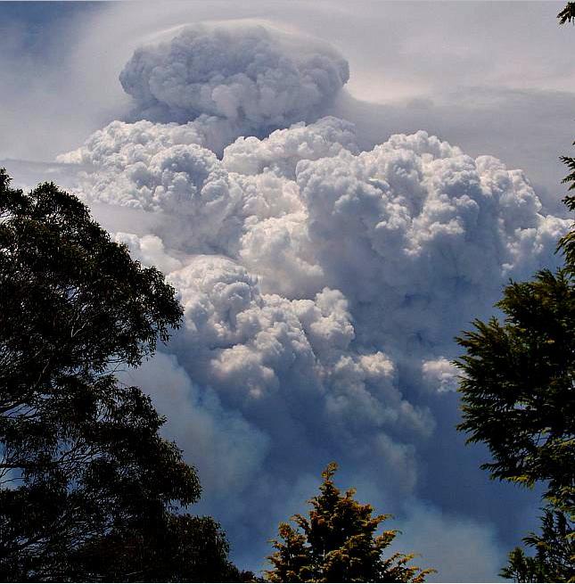